Effect of Check Dam on Sediment Load Under Vegetation Restoration in the Hekou-Longmen Region of the Yellow River
 Zeyu Zhang1
  Junrui Chai
 Zhanbin Li
- 1State Key Laboratory of Eco-hydraulics in Northwest Arid Region of China, Xi’an University of Technology, Xi’an, China
- 2School of Civil Engineering, Xijing University, Xi’an, China
- 3State Key Laboratory of Soil Erosion and Dry-land Farming on the Loess Plateau, Institute of Soil and Water Conservation, Chinese Academy of Sciences and Ministry of Water Resources, Yangling, China
- 4Ningxia Soil and Water Conservation Monitoring Station, Yinchuan, China
- 5Research Center on Soil and Water Conservation of the Ministry of Water Resources, China Institute of Water Resources and Hydropower Research, Beijing, China
With years of vegetation restoration and check dam construction on the Loess Plateau, the sediment load of the middle reaches of the Yellow River have decreased sharply; however, the effects of check dam on this decrease of sediment load with such extensive vegetation restoration remains unclear. In order to further clarify the effects of check dam on sediment load reduction under vegetation restoration, we calculated vegetation coverage and check dam index based on multi-source remote sensing data, and calculated sediment reduction rate caused by human activities by Mann-Kendall statistical test and double cumulative curve, then established regression equations incorporating the check dam index and the sediment reduction rate using data from different geomorphic regions with different vegetation coverages. The results showed that sediment load in the Hekou-Longmen region and its 17 tributaries decreased significantly every year, and the change in sediment load could be divided into 3 typical periods: the base period (P1), the period mainly impacted by check dam construction (P2) and the period with comprehensive impact of check dam construction and vegetation restoration (P3). Compared with sediment load of the tributaries during P1, the sediment load decreased by 60.96% during P2 and by 91.76% during P3. Compared with the contribution of human activities to the reduction in sediment load in P2, the contribution of human activities in P3 increased significantly, while that of precipitation decreased slightly. The sediment reduction effect of check dams is greater in basins with low vegetation coverage than in basins with high vegetation coverage. There are differences in sediment reduction effect of vegetation restorations in different geomorphic regions, and the effect of vegetation restoration alone have certain upper limits. Such as, the upper limit of sediment reduction rate of vegetation restoration for rivers flowing through the sandstorm region is 47.86%. Hence, only combined the construction of check dam with vegetation restoration can it achieve more significant sediment reduction benefit and control soil erosion more effectively.
Introduction
Soil erosion is a geomorphologic land degradation process that may cause environmental and property damage. Erosion not only lowers on-site soil quality but also causes significant off-site sediment-related problems (Munodawafa, 2007; Rickson, 2014; Poesen, 2018). The Loess Plateau in China, covering a 650,000-km2 area in the middle and upper streams of the Yellow River basin, experiences the most intense soil erosion in the world (Pal et al., 2018; Jia et al., 2022). The Hekou-Longmen region on the Loess Plateau is one of the main sources of rainstorms and floods in the middle reaches of the Yellow River. In addition, this region is the main source area of coarse sediment in the Yellow River: the interval coarse sediment amount of the region accounts for 73% of the Yellow River coarse sediment amount, while the area of the region accounts for 14.8% of the Yellow River basin (Xu, 2004).
To effectively control soil erosion and restore ecosystems, the Chinese government has implemented various soil and water conservation measures over the past several decades (Fu et al., 2011; Sun et al., 2014; Cheng et al., 2018), among which check dam construction and vegetation restoration are the most widely used measures to control water and soil erosion. The construction of check dams on the Loess Plateau started in the 1950s. Currently, there are 113,500 check dams with heights over 5 m that have been built, and 163,000 check dams are planned to be completed by 2020 (Xiang-zhou et al., 2004; Abbasi et al., 2019). The Chinese government has implemented the Conversion of Cropland to Forest and Grassland Project in the Loess Plateau since 1999, and the area of forest and grassland converted from cultivated land reached 16,000 km2; this conversion has significantly changed the land-use type and improved the vegetation coverage of the region (Xiao, 2014; Feng et al., 2016). Check dam construction and vegetation restoration on the Loess Plateau have played important roles in controlling soil erosion and reducing river sediment load (Yang et al., 2008; Zhao et al., 2014; Chen et al., 2016).
Check dams are constructed in channels to trap upstream sediment (Boix-Fayos et al., 2008). A small reservoir is usually formed behind a check dam, and the reservoir gradually fills with sediment (Castillo et al., 2007). The trapped sediment forms a wedge behind the check dam body, lowering the bed channel slope, controlling flooding, and stabilizing gullied hillslopes (Hevia et al., 2014; Mongil-Manso et al., 2016; Galicia et al., 2019). With the increase in trapped sediment, the sediment storage capacity of the check dam decreases gradually while the formed wedge can reinforce the lateral slope of the gully, and reduce the probability of lateral instability ensuing (Gao et al., 2014; Piton et al., 2017). Tang et al. (2020) showed that filled check dams were still able to reduce sediment yield by 4–52% under different deployment strategies. Vegetation restoration generally leads to a decrease in the generation of runoff and sediment detachment (Beguería et al., 2006). Zhang et al. (2014) showed that forest and grassland had different reduction effects on runoff and sediment. The soil and water conservation functions of forests are improved by vegetative cover and plant root systems, which increase interception and infiltration, and decrease runoff and soil erosion. Grasslands directly intercept sediment through surface vegetative canopies.
Because of climate change and large-scale soil and water conservation measures, the runoff and sediment discharge of the main stream of the Yellow River and most of its tributaries have decreased significantly in recent decades (Hu et al., 2019; Zhao et al., 2019; Zheng et al., 2019). Many studies have indicated that human activities have been the main reason for this decrease in sediment load in the Yellow River basin (Yao et al., 2016; Gao G. et al., 2017; Fu et al., 2017). Mu et al. (2012) showed that sediment reduction caused by human activities accounted for 81% of the sediment reduction in the Yellow River basin from 1979 to 2008. The research results of Li et al. (2019) showed that before the 1990s, the construction of check dams was the main cause of reduced river sediment load; since 1999, large-scale afforestation has played an increasingly important role in this reduction. In addition, the contributions of vegetation restoration and check dam construction to the reduction of river sediment load are different among different basins. Based on the result that the construction of check dams reduced runoff and sediment load by 12 and 11.7%, respectively, and vegetation restoration reduced runoff and sediment load by 20.7 and 53.2%, respectively, Shi et al. (2019) studied the Wudinghe Basin and concluded that the sediment reduction effect of vegetation restoration was much higher than that of check dams. However, while studying the Huangfuchuan Basin, Zhao et al. (2017) showed that in the absence of check dams, the change in land use caused by vegetation restoration reduced the sediment yield in the basin by 31.4%, and in the absence of land-use change, the construction of check dams reduced the sediment yield of the basin by 51.9%; thus, the sediment reduction effect of check dams was greater than that of vegetation restoration. Boix-Fayos et al. (2008) showed that check dam was a more effective sediment control measure than vegetation restoration, but check dam have only a short-lived influence on sediment trapping, while vegetation restoration has important sustained effects.
In general, although there have been many studies on the relative effects of vegetation restoration and check dam construction on sediment reduction, studies of different research areas may produce opposite conclusions; thus, many challenges remain in terms of quantifying these effects. The main aim of this study was to reveal the effect of check dams on sediment reduction under the condition of vegetation restoration by analyzing the relationship between the sediment reduction rate caused by human activities and vegetation restoration and check dam construction. The normalized Difference Vegetation Index (NDVI) of the catchment and the location and the control area of check dams can be obtained by remote sensing images. Therefore, multi-source remote sensing data provide a data basis for analyzing the impact of vegetation restoration and check dam construction on watershed runoff and sediment load change. The specific objectives were to 1) study the variation trend of sediment load in the main stream of the Yellow River and its 17 tributaries and subsequently quantify the contribution of human activities to sediment reduction and 2) analyze the relationship between the sediment reduction rate caused by human activities and vegetation restoration and check dam construction in 17 tributaries of the middle reaches of the Yellow River, and reveal the sediment reduction effect of check dams under different vegetation coverages.
Materials and Methods
Study Area
The Hekou-Longmen region is located in the upper part of the middle reaches of the Yellow River (between 108°02′—112°44′ E, 35°40′—40°34′ N), with a catchment area of 111,586 km2. The length of the main stream in this region is 723 km, and this main stream has an average channel gradient of 0.84%. There are 21 large tributaries with catchment areas greater than 1,000 km2, and 17 of these tributaries are studied in this paper (Figure 1). The region has an arid and semiarid climate, and the annual average precipitation is between 310 and 580 mm. The spatial precipitation distribution is extremely uneven and gradually decreases from southeast to northwest.
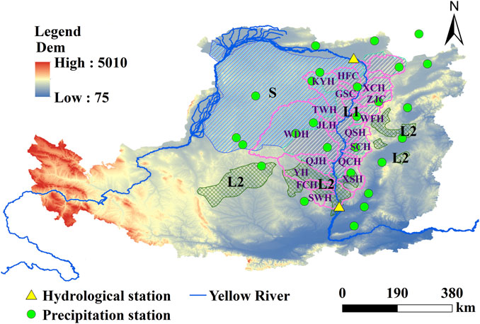
FIGURE 1. Location of study area. L1, L2 and S represent the first loess hill subregion, the second loess hill subregion and the sandstorm region, respectively. The pink shapes depict the boundaries of the 21 tributaries of the Hekou-Longmen region, and the tributaries labeled with names are the selected tributaries. The tributary names used here are abbreviated, where HPC represents huangpuchuan, KYH represents kuyehe, TWH represents tuweuhe, ZJC represents zhujiachuan, XCH represents xianchuanhe, GSC represents gushanchuan, WFH represents weifenhe, JLH represents jialuhe, QSH represents qiushuihe, SCH represents shanchuanhe, QCH represents quchanhe, WDH represents wudinghe, QJH represents qingjianhe, XSH represents xinshuihe, SWH represents shiwanghe, YH represents yanhe, FCH represents fenchuanhe.
This area is in the middle of the Loess Plateau, covered with a deep loess layer. The average gully density is 5–6 km/km2, and the gully area accounts for 40–50% of the total area. The geomorphologic types in this area are divided into the first loess hill subregion, the second loess hill subregion and the sandstorm region, accounting for 62, 24 and 14% of the basin area, respectively. The Hekou-Longmen region is the area experiencing the most serious soil erosion in China. In an area of 71,600 km2 in this region, the erosion modulus is above 5,000 t/(km2·a), accounting for 64.2% of the total area. The area in which the erosion modulus is between 15,000 t and 20,000 t/(km2·a) is 44,000 km2, accounting for 39.4% of the total area; furthermore, the area where the erosion modulus is higher than 20,000 t/(km2·a) is 12,000 km2, accounting for 10.8% of the total area (Li et al., 2014). To curb serious soil erosion, large-scale ecological construction measures have been implemented. Through measures such as returning farmland to forests and closing forests, the vegetation coverage of this region has significantly improved (Figure 2A). Additionally, 3,786 key check dams had been built by the end of 2011 (Figure 2B). After the treatment, the intensity of soil erosion in this area showed a downward trend, and the amount of sediment load decreased sharply (Gao et al., 2017b).
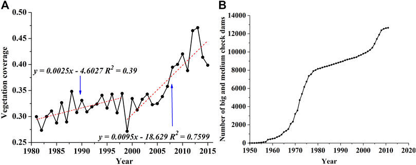
FIGURE 2. Variations in (A) vegetation coverage and (B) number of check dams in the Hekou-Longmen region.
Data Sources
Considering the continuity and integrity of the data, annual precipitation data from 1957 to 2015 from 26 national meteorological stations were selected, and the meteorological stations are distributed uniformly in the Hekou-Longmen region (Figure 1). The annual precipitation data were provided by the China Meteorological Data Service Center (http://data.cma.cn/). The average rainfall in the catchment area was calculated by the inverse distance weighted method (IDW) (Khan et al., 2020). The runoff and sediment data for the main stream and 17 tributaries of the Yellow River from 1957 to 2015 were obtained from the Loess Plateau Science Data Center (http://loess.geodata.cn/), the Hydrological Yearbook of the People’s Republic of China and the Yellow River Water Resources Bulletin. We used the differences in the measured runoff and sediment data between Hekou station and Longmen station to calculate the runoff and sediment data in the Hekou-Longmen region.
The vegetation data were calculated using the GIMMS NDVI dataset (period of 1982–2011, spatial resolution of 8 km). The dimidiate pixel model was used to calculate the vegetation coverage (
where
The key check dam data were obtained from the first national water conservancy census, which contains the construction year, control area, total storage capacity and siltation volume indexes at the end of 2011. The medium check dam data were obtained from the safety inspection of check dams conducted by the Ministry of Water Resources in 2008. Locations of all check dams were reviewed with Google Image, and control areas of some check dams were also reviewed.
Methods
Trend Analysis
In this study, the variation trend of sediment load was analyzed by the Mann-Kendall statistical test. The Mann-Kendall statistical test is an effective nonparametric test method used to explore the variation trend in a time series (Mann, 1945; Vegelius, 1978), and has been widely applied in analyses of the variation trends of time series in the fields of hydrology and meteorology. (Pingale et al., 2014; Ribeiro et al., 2015; Han et al., 2020). The Mann-Kendall statistical test is robust for nonnormally distributed data, and a few outliers in the sample will not affect the results; thus, this test can reveal the variation trend of a time series well.
Change-point Analysis
The change-point analysis completed in this study was applied to determine the years in which abrupt changes in the sediment record may have occurred. The change points were determined using a robust nonparametric method at a significance level of 5% (Pettitt, 1979). The Pettitt’s test is a non-parametric method widely applied to detect the abrupt changes of hydro-climatic variables (Li et al., 2020). This method detects a significant change in the mean of a time series when the exact time of the change is unknown.
Effect Evaluation Analysis
The double mass curve is a widely used method to quantitatively evaluate the effects of precipitation change or human activities on streamflow (Gao et al., 2017c). If the ratio of the two studied variables is constant, the double mass curve is straight; otherwise, a change in the characteristics of the precipitation, runoff or sediment of the studied region occurs at the break point. By establishing a linear regression equation between the precipitation and the sediment load data under original conditions, and then substituting the precipitation data obtained under the changed underlying surface conditions into this regression equation, the calculated sediment load represents the sediment load generated by the natural precipitation in the basin after the change in the underlying surface has occurred (Li et al., 2016). Then, the impact of precipitation change and human activities on sediment discharge can be calculated as follows (Yang et al., 2018):
where
Check Dam Index
The reservoir index (RI) is a dimensionless indicator proposed by López and Francés (2013) that is represented as follows:
where N is the number of reservoirs upstream of a given gauge station,
Referring to the RI, this study defined the check dam index (CDI), which was used to represent the influence of check dams on the sediment load. The CDI is calculated as follows:
where N is the number of check dams upstream of a given gauge station,
CDI includes multiple factors affecting sediment yield in a basin, which not only reflects the relationship between the area controlled by check dam and the area of the basin, but also reflects the relationship between the total storage capacity of check dam and sediment transport in the basin. Therefore, CDI can be used to reflect effects of check dam construction on sediment transport.
Results
Changes in Runoff and Sediment Load
According to the results of the Mann-Kendall statistical test analysis, the annual precipitation in the Hekou-Longmen region showed an insignificantly decreasing trend (p > 0.05), and the annual sediment load (Z = −6.87, p < 0.01) showed an extremely significant decreasing trend, as shown in Figure 3. Among the 17 tributaries, the sediment load of FCH showed a significant decreasing trend (p < 0.05), and the other tributaries showed extremely significant decreasing trends (p < 0.01), as shown in Table 1. On the basis of Pettitt change-point analysis and double mass curve analysis, two abrupt changes occurred in the sediment load of the study area; one change occurred in 1979, and one occurred in 1999, as shown in Figure 4. As shown in Figure 2, large-scale construction of key and medium check dams began in the 1970s, and vegetation coverage in the Hekou-Longmen region increased significantly after 1999. Therefore, based on check dam construction and vegetation restoration, the change in sediment load in the Hekou-Longmen region could be divided into 3 typical periods: the base period (P1, 1952–1979), characterized by a large sediment load and few control treatments; the period mainly impacted by check dam construction (P2, 1980–1999); and the period with comprehensive impact of check dam construction and vegetation restoration (P3, 2000–2017). The decrements in the sediment loads in P2 and P3 were 54.84 and 88.80%, respectively, compared with the sediment load in P1 (Table 2).
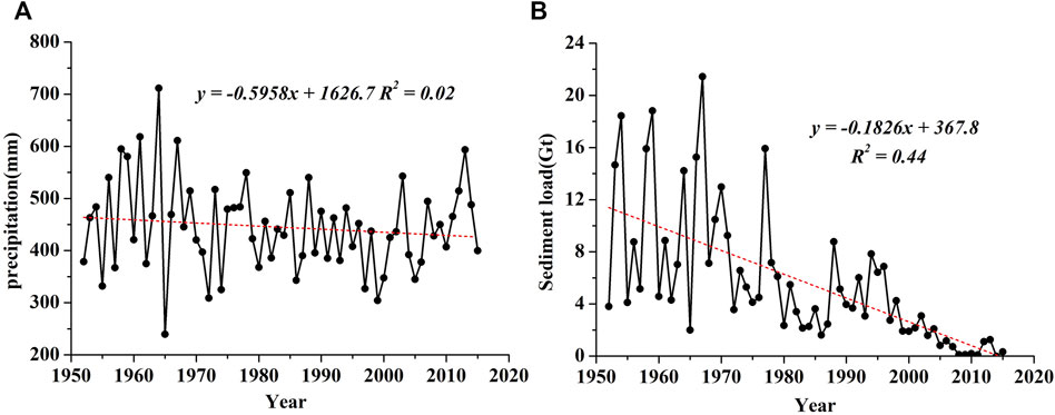
FIGURE 3. Variations in (A) precipitation and (B) sediment load in the Hekou-Longmen region.
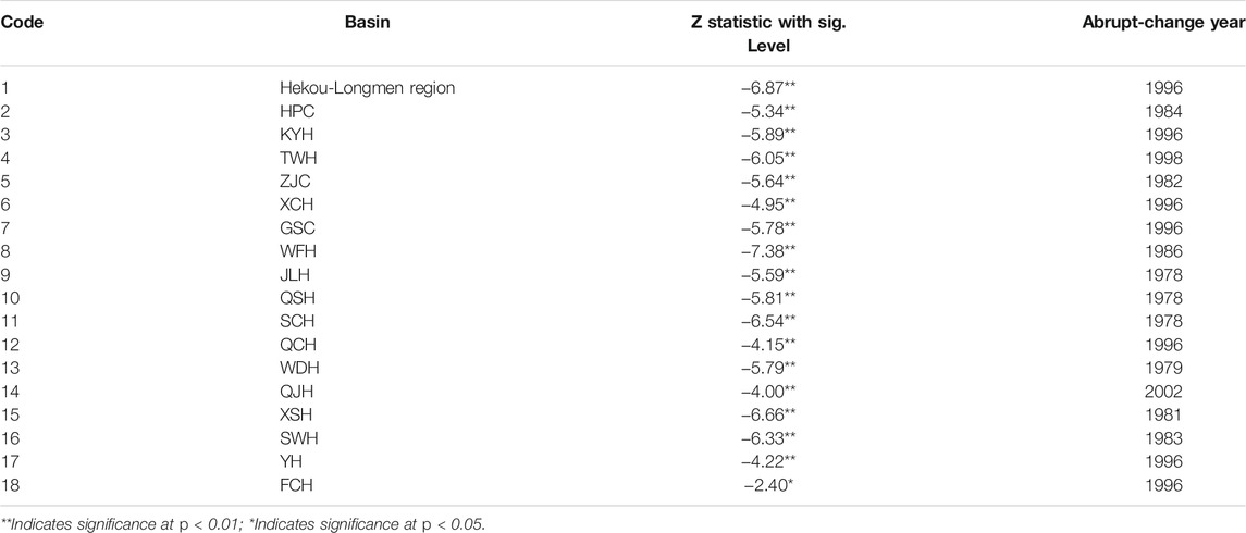
TABLE 1. Variation trend of sediment loads in the Hekou-Longmen region.
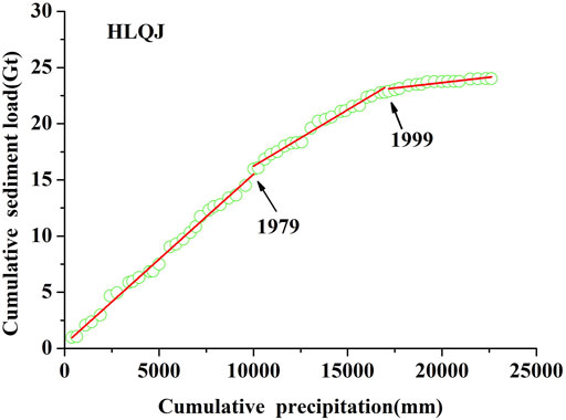
FIGURE 4. Double mass curve of precipitation and sediment load in the Hekou-Longmen region.
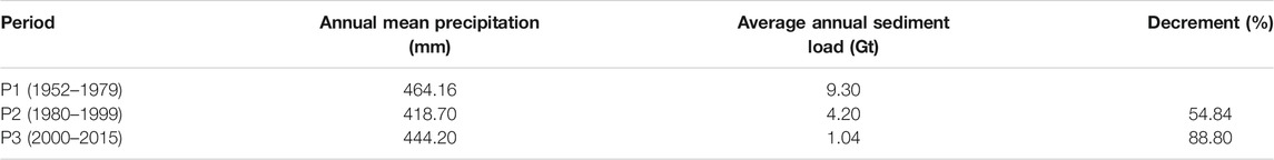
TABLE 2. Statistics of precipitation and sediment load.
Effects of Human Activities on Sediment Load
The observed decrease in sediment load was due to both precipitation and human activities. By Pettitt change-point analysis and double mass curve analysis, change points in the sediment load time series were recognized, and regression equations of the precipitation and sediment load during the base period were established (shown in Table 1 and Figure 5). Thirteen tributaries in the Hekou-Longmen region could be divided into the 3 typical periods (P1, P2 and P3), while the other 4 tributaries could be divided into 2 typical periods. By separating the effects of precipitation and human activities by double mass curve analysis, we found that the sediment load averagely decreased by 60.96% in P2 compared to that of P1, among which precipitation led to a decrease of 4.16% and human activities led to a decrease of 56.81%; additionally, the sediment load averagely decreased by 91.76% in P3 compared to that of P1, among which precipitation led to a decrease of 3.73% and human activities led to a decrease of 88.02% (shown in Figure 6). The sediment reduction rate in P3 was significantly higher than that in P2, the sediment reduction rate caused by human activities increased significantly in P3, and that caused by precipitation decreased slightly. The average contributions of precipitation and human activities to the reductions in sediment load were 6.79 and 93.21%, respectively. Thus, the reduction effect of human activities on the sediment load was much more significant than that of precipitation.
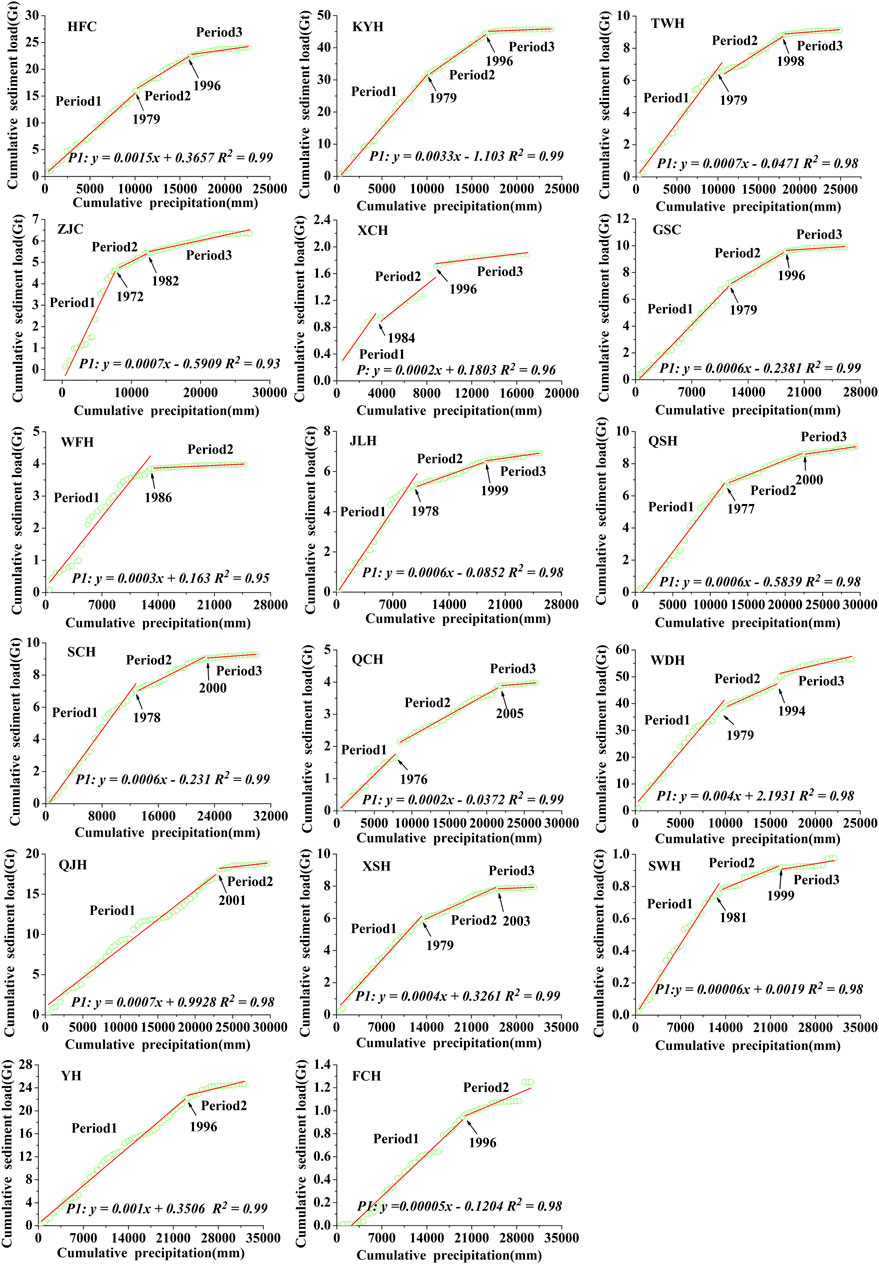
FIGURE 5. Double mass curves of precipitation and sediment load in tributaries in the Hekou-Longmen region.
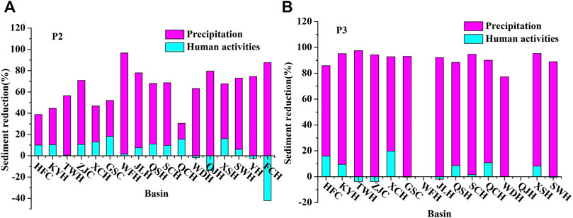
FIGURE 6. Sediment reduction due to precipitation and human activities in (A) P2 and (B) P3
Effects of Check Dams and Vegetation Restoration on Sediment Loads
To further investigate the influence of check dam construction and vegetation restoration on sediment load in the basin, the vegetation coverages and CDIs of the tributaries in different periods were calculated (shown in Table 3). The geomorphology in the Hekou-Longmen region is divided into the first loess hill subregion, the second loess hill subregion and the sandstorm region. Among them, the first loess hill subregion has the most slope land and the heaviest water erosion; the slope land in the second loess hill subregion is less, and part of sloping farmland is transformed into terraced fields, and the water erosion in the second loess hill subregion is strong; the sandstorm region has less water erosion and very strong wind erosion (Huang, 1955). In addition, there are 9 tributaries in the Hekou-Longmen region (such as ZJC) that are located in the first loess hill subregion. The upper reaches of 4 tributaries (such as WDH) are located in the sandstorm region, and the lower reaches of these tributaries are located in the first loess hill subregion. The other 4 tributaries, including YH, are located in the second loess hill subregion (Figure 1). According to relevant studies, vegetation coverage values of 0–0.45 can be classified as low-level values, and those of 0.45–0.6 can be classified as high-level values (Guo et al., 2019).
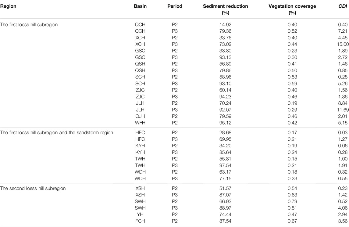
TABLE 3. Vegetation coverage and the CDI in the Hekou-Longmen region.
The relationships between the CDI and the sediment reduction rate caused by human activities were established under different geomorphologic regions and different vegetation coverage (Figure 7). As shown in Figure 7, both of the sediment reduction rates in basins with high and low vegetation coverage in different geomorphologic regions gradually increased with an increasing CDI. In regions with the same geomorphology, the increase in high-vegetation-coverage basins was significantly slower than that in low-vegetation-coverage basins (shown as Figure 7A); a similar regularity was observed among regions with different geomorphological characteristics (shown in Figures 7B,C), which indicated that the contribution of check dam construction to sediment reduction in low-vegetation-coverage basins was higher than that in high-vegetation-coverage basins.
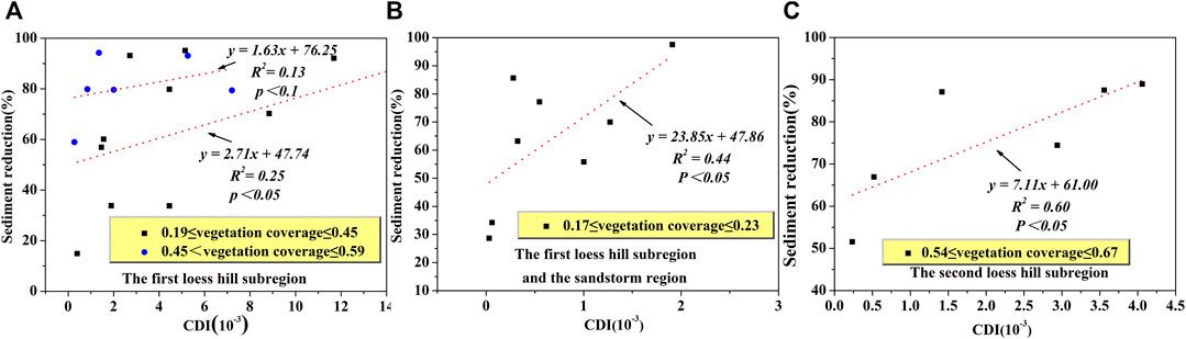
FIGURE 7. Relationships between the CDI and sediment reduction in the (A) first loess hill subregion, (B) first loess hill subregion and sandstorm region and (C) second loess hill subregion.
For the state where the CDI = 0, the sediment reduction rates of high-vegetation-coverage basins and low-vegetation-coverage basins in the first loess hill subregion were 76.25 and 47.74%, respectively, and vegetation restoration alone could increase the sediment reduction rate by 59.72% (shown in Figure 7A). With the same CDI = 0, the sediment reduction rate of the basins in both the first loess hill subregion and the sandstorm region was 47.86% (shown in Figure 7B). The conditions in the sandstorm region make it difficult to improve the vegetation coverage; thus, it is necessary to further control the sediment by check dams. With CDI of 0, the sediment reduction rate of the basins in the second loess hill subregion was 61% (shown in Figure 7C), which indicates that without check dams, sediment reduction attributed to vegetation has a certain upper limit.
Discussion
Effects of Vegetation Restoration on Sediment Load
Vegetation restoration not only increases the interception and infiltration of rainfall but also increases the roughness of the land surface, leading to reductions in runoff and sediment yield in a basin (Thompson et al., 2010; Feng et al., 2012). Perennial vegetation is often considered to be effective in stabilizing the soil and reducing erosion (Wang et al., 2015). The results of this study showed that vegetation restoration in different geomorphic regions had different effects on sediment reduction, and sediment reduction effects attributed to vegetation restoration had certain upper limits in most regions. Only when combined with check dams could this sediment reduction benefit increase. The study by Zhao et al. (2017) in the HFC basin also showed that vegetation restoration alone could reduce the sediment load by 31.4%, while vegetation restoration combined with check dam construction could reduce the sediment load by 80%.
The fact that sediment reduction due to vegetation restoration has an upper limit can be attributed to multiple reasons. First, the dry climate and impoverished soil on the Loess Plateau make some areas unsuitable for afforestation; in these areas, the increase in vegetation coverage has an upper limit (Lu et al., 2012). Second, excessive afforestation can lead to the formation of dry layers in soil, causing ecosystem degradation (Jia et al., 2017; Shao et al., 2018). In addition, when vegetation coverage increases to a certain threshold, the sediment yield is no longer reduced. Liu et al. (2014) showed that there is an exponential relationship between the sediment yield coefficient and the effective vegetation percentage. When the effective vegetation percentage is less than 40%, the improvement in vegetation has a significant impact on sediment reduction in the basin; conversely, when the effective vegetation percentage is more than 70%, the sediment yield coefficient tends to be stable. In addition, the study by Gao et al. (2020) argued that vegetation restoration intensified gravity erosion of the studied channel to a certain extent and increased the sediment yield of the studied basin ensuing. Compared with the anchoring action of a vegetation root system, a soil moisture change on the slope caused by vegetation has a greater effect on intensifying gravity erosion under heavy rainfall events. Therefore, vegetation restoration alone cannot sustainably and effectively reduce sediment loads.
Effects of Check Dam Construction on Sediment Loads
Check dams are usually built to control water and sediment fluxes along stream channels (Nyssen et al., 2004). As an efficient engineering measure used to control soil and water loss erosion, check dams are commonly used worldwide (Mekonnen et al., 2015). Xu et al. showed that the construction of check dams in the YH basin decreased the runoff and sediment load by 15.5–28.9% and 79.4–85.5%, respectively, during the rainy season (Xu et al., 2013). The results of this study showed that the construction of check dams had an obvious reduction effect on sediment load, and the sediment reduction benefits in basins with low vegetation coverage were greater than those in basins with high vegetation coverage; these results were consistent with the conclusions of current researches. The sediment reductions caused by the construction of check dams obtained in studies by Boix-Fayos et al. (2008), Polyakov et al. (2014) and Shi et al. (2019) ranged from 11.7 to 77%. The sediment reduction benefits of check dams among different basins are related to various factors, such as the basin area, climate and vegetation coverage. It is worth noting that a check dam can quickly intercept sediment and has a significant sediment reduction effect in the early stage of vegetation restoration; this sediment reduction effect gradually decreases with the restoration of vegetation (Zhang et al., 2015; Zhang et al., 2017).
A check dam is a dynamic system, its sediment storage capacity will gradually lose with the siltation of sediments behind the dam, resulting that of the sediment intercept effect of the check dam have very obvious timelines. When the proportion of silted storage of a key check dam reaches 0.77, and the proportion of silted storage of a small or medium check dam reaches 0.88, the check dam will lose its sediment intercept effect (Gao et al., 2014; Liu et al., 2018; Liu et al., 2021). However, Tang et al. (2020) showed that filled check dams were still able to reduce sediment yield by 4–52% under different deployment strategies. The check dam not only has effects on the hydrology and sediment process, but also has some ecological and environmental effects that deserve attention. Bombino et al. (2006) showed that an influence of check dams was found especially in the lower torrent reaches, with a longitudinal diversification of vegetation types and the creation, either immediately up or downstream, of habitats characterized by new biological and ecological formations. Hartman et al. (2016) showed that check dams increase vegetation and standing water at a local scale, and lead to increased greenness at a basin scale.
Conclusion
The annual sediment load in the Hekou-Longmen region showed an extremely significant decreasing trend. Two abrupt changes occurred in the sediment load of the study area; one change occurred in 1979 and one occurred in 1999. The changes in the sediment load of the Hekou-Longmen region could be divided into 3 typical periods: the base period (P1, 1952–1979), engineering measure impact period (P2, 1980–1999) and comprehensive impact period (P3, 2000–2017). Among the 17 studied tributaries in the Hekou-Longmen region, the sediment load of FCH showed a significant decreasing trend, and the sediment loads of the other tributaries showed extremely significant decreasing trends. The sediment load of the tributaries averagely decreased by 60.96% during P2 and by 91.76% during P3. The average contribution of precipitation to sediment load reduction was 6.79% and that of human activities was 93.21%. Compared with P2, the contribution of human activities to the sediment load reduction in P3 increased significantly, while the contribution of precipitation to the sediment load reduction decreased slightly. The construction of check dams has an obvious sediment reduction effect, and this effect is greater in basins with low vegetation coverage than in basins with high vegetation coverage. Vegetation restoration has different effects on sediment reduction among different geomorphic regions, and the sediment reduction effects of vegetation restoration in most regions have certain upper limits. Only when combined with check dams can the sediment reduction benefit of vegetation restoration increase.
Data Availability Statement
The original contributions presented in the study are included in the article/Supplementary Material, further inquiries can be directed to the corresponding author.
Author Contributions
Conceptualization, ZZ and ZL; methodology, ZZ, JC and XZ; formal analysis, ZZ and LC; software, ZZ and KY; ZZ wrote the manuscript and all authors contributed to improving the paper.
Funding
This research was supported by the National Natural Science Foundation of China (52079104, 52009103, 51879281, 52179043, 51979290), Program for Science and Technology Innovation Research Team of Shaanxi Province (2018TD-037), the Natural Science Foundation of Shaanxi Province (2017JZ013), the Leadership Talent Project of Shaanxi Province High-Level Talents Special Support Program in Science and Technology Innovation (2017), Ningxia Water Conservancy Science and Technology Project (SBZZ-J-2021–12).
Conflict of Interest
The authors declare that the research was conducted in the absence of any commercial or financial relationships that could be construed as a potential conflict of interest.
Publisher’s Note
All claims expressed in this article are solely those of the authors and do not necessarily represent those of their affiliated organizations, or those of the publisher, the editors, and the reviewers. Any product that may be evaluated in this article, or claim that may be made by its manufacturer, is not guaranteed or endorsed by the publisher.
References
Abbasi, N. A., Xu, X., Lucas-Borja, M. E., Dang, W., and Liu, B. (2019). The Use of Check Dams in Watershed Management Projects: Examples from Around the World. Sci. Total Environ. 676, 683–691. doi:10.1016/j.scitotenv.2019.04.249
Beguería, S., López‐moreno, J. I., Gómez‐villar, A., Rubio, V., Lana‐renault, N., and García‐ruiz, J. M. (2006). Fluvial Adjustments to Soil Erosion and Plant Cover Changes in the Central Spanish Pyrenees. Geografiska Annaler: Ser. A, Phys. Geogr. 88, 177–186. doi:10.1111/j.1468-0459.2006.00293.x
Boix-Fayos, C., de Vente, J., Martínez-Mena, M., Barberá, G. G., and Castillo, V. (2008). The Impact of Land Use Change and Check-Dams on Catchment Sediment Yield. Hydrol. Process. 22 (25), 4922–4935. doi:10.1002/hyp.7115
Bombino, G., Tamburino, V., and Zimbone, S. M. (2006). Assessment of the Effects of Check-Dams on Riparian Vegetation in the Mediterranean Environment: A Methodological Approach and Example Application. Ecol. Eng. 27 (2), 134–144. doi:10.1016/j.ecoleng.2006.01.005
Castillo, V. M., Mosch, W. M., García, C. C., Barberá, G. G., Cano, J. A. N., and López-Bermúdez, F. (2007). Effectiveness and Geomorphological Impacts of Check Dams for Soil Erosion Control in a Semiarid Mediterranean Catchment: El Cárcavo (Murcia, Spain). CATENA 70 (3), 416–427. doi:10.1016/j.catena.2006.11.009
Chen, L., Wei, W., Fu, B., and Lü, Y. (2016). Soil and Water Conservation on the Loess Plateau in China: Review and Perspective. Prog. Phys. Geogr. Earth Environ. 31 (4), 389–403. doi:10.1177/0309133307081290
Cheng, Y., Li, P., Xu, G., Li, Z., Gao, H., Zhao, B., et al. (2018). Effects of Soil Erosion and Land Use on Spatial Distribution of Soil Total Phosphorus in a Small Watershed on the Loess Plateau, China. Soil Tillage Res. 184, 142–152. doi:10.1016/j.still.2018.07.011
Feng, X. M., Sun, G., Fu, B. J., Su, C. H., Liu, Y., and Lamparski, H. (2012). Regional Effects of Vegetation Restoration on Water Yield across the Loess Plateau, China. Hydrol. Earth Syst. Sci. 16 (8), 2617–2628. doi:10.5194/hess-16-2617-2012
Feng, X., Fu, B., Piao, S., Wang, S., Ciais, P., Zeng, Z., et al. (2016). Revegetation in China's Loess Plateau Is Approaching Sustainable Water Resource Limits. Nat. Clim. Change 6 (11), 1019–1022. doi:10.1038/nclimate3092
Fu, B., Liu, Y., Lü, Y., He, C., Zeng, Y., and Wu, B. (2011). Assessing the Soil Erosion Control Service of Ecosystems Change in the Loess Plateau of China. Ecol. Complexity 8 (4), 284–293. doi:10.1016/j.ecocom.2011.07.003
Fu, B., Wang, S., Liu, Y., Liu, J., Liang, W., and Miao, C. (2017). Hydrogeomorphic Ecosystem Responses to Natural and Anthropogenic Changes in the Loess Plateau of China. Annu. Rev. Earth Planet. Sci. 45 (1), 223–243. doi:10.1146/annurev-earth-063016-020552
Galicia, S., Navarro-Hevia, J., Martínez-Rodríguez, A., Mongil-Manso, J., and Santibáñez, J. (2019). 'Green', Rammed Earth Check Dams: A Proposal to Restore Gullies under Low Rainfall Erosivity and Runoff Conditions. Sci. Total Environ. 676, 584–594. doi:10.1016/j.scitotenv.2019.04.189
Gao, Y., Guo, Y., Liu, X., and He, X. (2014). Failure Criteria of the Warping Dams on Sediment Interception in the Middle Yellow River in Northern Shaanxi (In Chinese). Acta Geogr. Sin. 69 (1), 73–79. doi:10.11821/dlxb201401007
Gao, G., Zhang, J., Liu, Y., Ning, Z., Fu, B., and Sivapalan, M. (2017a). Spatio-temporal Patterns of the Effects of Precipitation Variability and Land Use/cover Changes on Long-Term Changes in Sediment Yield in the Loess Plateau, China. Hydrol. Earth Syst. Sci. 21 (9), 4363–4378. doi:10.5194/hess-21-4363-2017
Gao, P., Deng, J., Chai, X., Mu, X., Zhao, G., Shao, H., et al. (2017b). Dynamic Sediment Discharge in the Hekou-Longmen Region of Yellow River and Soil and Water Conservation Implications. Sci. Total Environ. 578, 56–66. doi:10.1016/j.scitotenv.2016.06.128
Gao, P., Li, P., Zhao, B., Xu, R., Zhao, G., Sun, W., et al. (2017c). Use of Double Mass Curves in Hydrologic Benefit Evaluations. Hydrol. Process. 31 (26), 4639–4646. doi:10.1002/hyp.11377
Gao, H., Xu, X., Zhang, H., Jiang, Y., and Zhao, T. (2020). How Effective Is Vegetation in Reducing Gravity Erosion on Loess Gully Sidewall under Intense Rainfalls? Land Degrad. Dev. 31 (17), 2605–2619. doi:10.1002/ldr.3634
Guo, Y., Wang, N., Chu, X., Li, C., Luo, X., and Feng, H. (2019). Analyzing Vegetation Coverage Changes and its Reasons on the Loess Plateau Based on Google Earth Engine (In Chinese). China Environ. Sci. 39 (11), 4804–4811. doi:10.19674/j.cnki.issn1000-6923.2019.0560
Han, H., Hou, J., Huang, M., Li, Z., Xu, K., Zhang, D., et al. (2020). Impact of Soil and Water Conservation Measures and Precipitation on Streamflow in the Middle and Lower Reaches of the Hulu River Basin, China. Catena 195, 104792. doi:10.1016/j.catena.2020.104792
Hartman, B. D., Bookhagen, B., and Chadwick, O. A. (2016). The Effects of Check Dams and Other Erosion Control Structures on the Restoration of Andean Bofedal Ecosystems. Restor Ecol. 24 (6), 761–772. doi:10.1111/rec.12402
Hevia, J. N., de Araújo, J. C., and Manso, J. M. (2014). Assessment of 80 Years of Ancient-Badlands Restoration in Saldaña, Spain. Earth Surf. Process. Landforms 39 (12), 1563–1575. doi:10.1002/esp.3541
Hu, J., Zhao, G., Mu, X., Tian, P., Gao, P., and Sun, W. (2019). Quantifying the Impacts of Human Activities on Runoff and Sediment Load Changes in a Loess Plateau Catchment, China. J. Soils Sediments 19 (11), 3866–3880. doi:10.1007/s11368-019-02353-z
Huang, B. (1955). Experience and Lessons in Drawing up Soil Erosion Zoning Map in the Middle Yellow River basin (In Chinese). Chin. Sci. Bull. 12, 15–21.
Jia, X., Shao, M. a., Zhu, Y., and Luo, Y. (2017). Soil Moisture Decline Due to Afforestation across the Loess Plateau, China. J. Hydrol. 546, 113–122. doi:10.1016/j.jhydrol.2017.01.011
Jia, L., Yu, K.-x., Li, Z.-b., Li, P., Zhang, J.-z., Wang, A.-n., et al. (2022). Temporal and Spatial Variation of Rainfall Erosivity in the Loess Plateau of China and its Impact on Sediment Load. Catena 210, 105931. doi:10.1016/j.catena.2021.105931
Khan, I., Waqas, T., Samiullah, , and Ullah, S. (2020). Precipitation Variability and its Trend Detection for Monitoring of Drought hazard in Northern Mountainous Region of Pakistan. Arab J. Geosci. 13 (15), 1–18. doi:10.1007/s12517-020-05700-4
Li, E., Mu, X., Zhao, G., Gao, P., and Shao, H. (2014). Variation of Runoff and Precipitation in the Hekou-Longmen Region of the Yellow River Based on Elasticity Analysis. Sci. World J. 2014, 1–11. doi:10.1155/2014/929858
Li, Z., Xu, X., Yu, B., Xu, C., Liu, M., and Wang, K. (2016). Quantifying the Impacts of Climate and Human Activities on Water and Sediment Discharge in a Karst Region of Southwest China. J. Hydrol. 542, 836–849. doi:10.1016/j.jhydrol.2016.09.049
Li, J., Liu, Q., Feng, X., Shi, W., Fu, B., Lü, Y., et al. (2019). The Synergistic Effects of Afforestation and the Construction of Check‐Dams on Sediment Trapping: Four Decades of Evolution on the Loess Plateau, China. Land Degrad. Dev. 30 (6), 622–635. doi:10.1002/ldr.3248
Li, R., Xiong, L., Xiong, B., Li, Y., Xu, Q., Cheng, L., et al. (2020). Investigating the Downstream Sediment Load Change by an index Coupling Effective Rainfall Information with Reservoir Sediment Trapping Capacity. J. Hydrol. 590, 125200. doi:10.1016/j.jhydrol.2020.125200
Liu, X., Yang, S., Dang, S., Luo, Y., Li, X., and Zhou, X. (2014). Response of Sediment Yield to Vegetation Restoration at a Large Spatial Scale in the Loess Plateau. Sci. China Technol. Sci. 57 (8), 1482–1489. doi:10.1007/s11431-014-5605-2
Liu, X., Gao, Y., Ma, S., and Dong, G. (2018). Sediment Reduction of Warping Dams and its Timeliness in the Loess Plateau (In Chinese). J. Hydraul. Eng. 49 (2), 145–155. doi:10.13243/j.cnki.slxb.20170925
Liu, X., Gao, Y., Tian, Y., Li, X., and Ma, J. (2021). SedimentIntercepted by Dams and the Sediment Production Situation Restoration of theLast 100 Years in the Yellow River Basin (In Chinese). Yellow River 43 (7), 19–23. doi:10.3969/j.issn.1000-1379.2021.07.004
López, J., and Francés, F. (2013). Non-stationary Flood Frequency Analysis in continental Spanish Rivers, Using Climate and Reservoir Indices as External Covariates. Hydrol. Earth Syst. Sci. 17, 3189–3203. doi:10.5194/hess-17-3189-2013
Lü, Y., Fu, B., Feng, X., Zeng, Y., Liu, Y., Chang, R., et al. (2012). A Policy-Driven Large Scale Ecological Restoration: Quantifying Ecosystem Services Changes in the Loess Plateau of China. PLoS One 7 (2), e31782. doi:10.1371/journal.pone.0031782
Mann, H. B. (1945). Nonparametric Tests against Trend. Econometrica 13 (3), 245–259. doi:10.2307/1907187
Mekonnen, M., Keesstra, S. D., Stroosnijder, L., Baartman, J. E. M., and Maroulis, J. (2015). Soil Conservation through Sediment Trapping: A Review. Land Degrad. Develop. 26 (6), 544–556. doi:10.1002/ldr.2308
Mongil-Manso, J., Navarro-Hevia, J., Díaz-Gutiérrez, V., Cruz-Alonso, V., and Ramos-Díez, I. (2016). Badlands forest Restoration in Central Spain after 50 Years under a Mediterranean-Continental Climate. Ecol. Eng. 97, 313–326. doi:10.1016/j.ecoleng.2016.10.020
Mu, X., Zhang, X., Shao, H., Gao, P., Wang, F., Jiao, J., et al. (2012). Dynamic Changes of Sediment Discharge and the Influencing Factors in the Yellow River, China, for the Recent 90 Years. Clean. Soil Air Water 40 (3), 303–309. doi:10.1002/clen.201000319
Munodawafa, A. (2007). Assessing Nutrient Losses with Soil Erosion under Different Tillage Systems and Their Implications on Water Quality. Phys. Chem. Earth, Parts A/B/C 32 (15-18), 1135–1140. doi:10.1016/j.pce.2007.07.033
Nyssen, J., Veyret-Picot, M., Poesen, J., Moeyersons, J., Haile, M., Deckers, J., et al. (2004). The Effectiveness of Loose Rock Check Dams for Gully Control in Tigray, Northern Ethiopia. Soil Use manage 20 (1), 55–64. doi:10.1079/sum2003223
Pal, D., Galelli, S., Tang, H., and Ran, Q. (2018). Toward Improved Design of Check Dam Systems: A Case Study in the Loess Plateau, China. J. Hydrol. 559, 762–773. doi:10.1016/j.jhydrol.2018.02.051
Pettitt, A. N. (1979). A Non-parametric Approach to the Change-Point Problem. Appl. Stat. 28 (2), 126–135. doi:10.2307/2346729
Pingale, S. M., Khare, D., Jat, M. K., and Adamowski, J. (2014). Spatial and Temporal Trends of Mean and Extreme Rainfall and Temperature for the 33 Urban Centers of the Arid and Semi-arid State of Rajasthan, India. Atmos. Res. 138, 73–90. doi:10.1016/j.atmosres.2013.10.024
Piton, G., Carladous, S., Recking, A., Tacnet, J. M., Liébault, F., Kuss, D., et al. (2017). Why Do We Build Check Dams in Alpine Streams? an Historical Perspective from the French Experience. Earth Surf. Process. Landforms 42 (1), 91–108. doi:10.1002/esp.3967
Poesen, J. (2018). Soil Erosion in the Anthropocene: Research Needs. Earth Surf. Process. Landforms 43 (1), 64–84. doi:10.1002/esp.4250
Polyakov, V. O., Nichols, M. H., McClaran, M. P., and Nearing, M. A. (2014). Effect of Check Dams on Runoff, Sediment Yield, and Retention on Small Semiarid Watersheds. J. Soil Water Conserv. 69 (5), 414–421. doi:10.2489/jswc.69.5.414
Ribeiro, L., Kretschmer, N., Nascimento, J., Buxo, A., Rötting, T., Soto, G., et al. (2015). Evaluating Piezometric Trends Using the Mann-Kendall Test on the Alluvial Aquifers of the Elqui River basin, Chile. Hydrol. Sci. J. 60 (10), 1840–1852. doi:10.1080/02626667.2014.945936
Rickson, R. J. (2014). Can Control of Soil Erosion Mitigate Water Pollution by Sediments? Sci. Total Environ. 468-469, 1187–1197. doi:10.1016/j.scitotenv.2013.05.057
Shao, M. a., Wang, Y., Xia, Y., and Jia, X. (2018). Soil Drought and Water Carrying Capacity for Vegetation in the Critical Zone of the Loess Plateau: A Review. Vadose Zone J. 17 (1), 170077. doi:10.2136/vzj2017.04.0077
Shi, P., Zhang, Y., Ren, Z., Yu, Y., Li, P., and Gong, J. (2019). Land-use Changes and Check Dams Reducing Runoff and Sediment Yield on the Loess Plateau of China. Sci. Total Environ. 664, 984–994. doi:10.1016/j.scitotenv.2019.01.430
Sun, W., Shao, Q., Liu, J., and Zhai, J. (2014). Assessing the Effects of Land Use and Topography on Soil Erosion on the Loess Plateau in China. Catena 121, 151–163. doi:10.1016/j.catena.2014.05.009
Tang, H., Pan, H., and Ran, Q. (2020). Impacts of Filled Check Dams with Different Deployment Strategies on the Flood and Sediment Transport Processes in a Loess Plateau Catchment. Water 12 (5), 1319. doi:10.3390/w12051319
Thompson, S. E., Harman, C. J., Heine, P., and Katul, G. G. (2010). Vegetation-infiltration Relationships across Climatic and Soil Type Gradients. J. Geophys. Res. Biogeosci. 115 (G2), 1–12. doi:10.1029/2009jg001134
Vegelius, J. (1978). On the Utility of the E-Correlation Coefficient Concept in Psychological Research. Educ. Psychol. Meas. 38 (3), 605–611. doi:10.1177/001316447803800301
Wang, S., Fu, B., Piao, S., Lü, Y., Ciais, P., Feng, X., et al. (2015). Reduced Sediment Transport in the Yellow River Due to Anthropogenic Changes. Nat. Geosci. 9 (1), 38–41. doi:10.1038/ngeo2602
Xiang-zhou, X., Hong-wu, Z., and Ouyang, Z. (2004). Development of Check-Dam Systems in Gullies on the Loess Plateau, China. Environ. Sci. Pol. 7 (2), 79–86. doi:10.1016/j.envsci.2003.12.002
Xiao, J. (2014). Satellite Evidence for Significant Biophysical Consequences of the “Grain for Green” Program on the Loess Plateau in China. J. Geophys. Res. Biogeosci. 119 (12), 2261–2275. doi:10.1002/2014jg002820
Xu, Y. D., Fu, B. J., and He, C. S. (2013). Assessing the Hydrological Effect of the Check Dams in the Loess Plateau, China, by Model Simulations. Hydrol. Earth Syst. Sci. 17 (6), 2185–2193. doi:10.5194/hess-17-2185-2013
Xu, G., Zhang, J., Li, P., Li, Z., Lu, K., Wang, X., et al. (2018). Vegetation Restoration Projects and Their Influence on Runoff and Sediment in China. Ecol. Indic. 95, 233–241. doi:10.1016/j.ecolind.2018.07.047
Xu, J. (2004). Short-Term Tendency of Water and Sediment Reduction through Soil Conservation and its Cause of Formation in Coarse and Sediment Concentrated Regions in the Middle Yellow River (In Chinese). Soil Water Conserv. China 7, 3–6. doi:10.14123/j.cnki
Yang, T., Zhang, Q., Chen, Y. D., Tao, X., Xu, C.-y., and Chen, X. (2008). A Spatial Assessment of Hydrologic Alteration Caused by Dam Construction in the Middle and Lower Yellow River, China. Hydrol. Process. 22 (18), 3829–3843. doi:10.1002/hyp.6993
Yang, X., Sun, W., Li, P., Mu, X., Gao, P., and Zhao, G. (2018). Reduced Sediment Transport in the Chinese Loess Plateau Due to Climate Change and Human Activities. Sci. Total Environ. 642, 591–600. doi:10.1016/j.scitotenv.2018.06.061
Yao, W., Xiao, P., Shen, Z., Wang, J., and Jiao, P. (2016). Analysis of the Contribution of Multiple Factors to the Recent Decrease in Discharge and Sediment Yield in the Yellow River Basin, China. J. Geogr. Sci. 26 (9), 1289–1304. doi:10.1007/s11442-016-1227-7
Zhang, X., Yu, G. Q., Li, Z. B., and Li, P. (2014). Experimental Study on Slope Runoff, Erosion and Sediment under Different Vegetation Types. Water Resour. Manage. 28 (9), 2415–2433. doi:10.1007/s11269-014-0603-5
Zhang, J., Zhang, T., Lei, Y., Zhang, X., and Li, R. (2015). Streamflow Regime Variations Following Ecological Management on the Loess Plateau, China. Forests 7 (12), 6. doi:10.3390/f7010006
Zhang, J., Zhang, X., Li, R., Chen, L., and Lin, P. (2017). Did Streamflow or Suspended Sediment Concentration Changes Reduce Sediment Load in the Middle Reaches of the Yellow River? J. Hydrol. 546, 357–369. doi:10.1016/j.jhydrol.2017.01.002
Zhao, G., Mu, X., Strehmel, A., and Tian, P. (2014). Temporal Variation of Streamflow, Sediment Load and Their Relationship in the Yellow River basin, China. PLoS One 9 (3), e91048. doi:10.1371/journal.pone.0091048
Zhao, G., Kondolf, G. M., Mu, X., Han, M., He, Z., Rubin, Z., et al. (2017). Sediment Yield Reduction Associated with Land Use Changes and Check Dams in a Catchment of the Loess Plateau, China. Catena 148, 126–137. doi:10.1016/j.catena.2016.05.010
Zhao, Q., Wang, L., Liu, H., and Zhang, Q. (2019). Runoff and Sediment Variation and Attribution over 60 Years in Typical Loess Plateau Basins. J. Soils Sediments 19 (10), 3631–3647. doi:10.1007/s11368-019-02345-z
Keywords: sediment load change, vegetation restoration, check dam, loess plateau, middle reaches of the yellow river
Citation: Zhang Z, Chai J, Li Z, Chen L, Yu K, Yang Z, Zhang X and Zhao Y (2022) Effect of Check Dam on Sediment Load Under Vegetation Restoration in the Hekou-Longmen Region of the Yellow River. Front. Environ. Sci. 9:823604. doi: 10.3389/fenvs.2021.823604
Received: 29 November 2021; Accepted: 20 December 2021;
Published: 14 January 2022.
Edited by:
Teresa Ferreira, University of Lisbon, PortugalReviewed by:
Rui Manuel Vitor Cortes, University of Trás-os-Montes and Alto Douro, PortugalQian Zhang, University of Maryland Center for Environmental Science (UMCES), United States
Copyright © 2022 Zhang, Chai, Li, Chen, Yu, Yang, Zhang and Zhao. This is an open-access article distributed under the terms of the Creative Commons Attribution License (CC BY). The use, distribution or reproduction in other forums is permitted, provided the original author(s) and the copyright owner(s) are credited and that the original publication in this journal is cited, in accordance with accepted academic practice. No use, distribution or reproduction is permitted which does not comply with these terms.
*Correspondence: Junrui Chai, jrchai@xaut.edu.cn