Heterogeneous Impact of Land-Use on Climate Change: Study From a Spatial Perspective
 Shuaishuai Jia
 Cunyi Yang
 Mengxin Wang
 Pierre Failler
- 1Guangdong Research Center for Financial Development and Data Science, Guangzhou University, Guangzhou, China
- 2School of Economics and Statistics, Guangzhou University, Guangzhou, China
- 3Guangzhou Institute of International Finance, Guangzhou University, Guangzhou, China
- 4Department of Economics and Finance, Portsmouth Business School, University of Portsmouth, Portsmouth, United Kingdom
Studies have shown that land and climate interact in complex ways through multiple biophysical and biogeochemical feedbacks. In this interaction mechanism, the carbon fixation effect among different land-use types and objective conditions among different regions have significant gaps, leading to the heterogeneous impact of land-use on climate change. This study takes temperature change as the observation index to reflect climate change, and analyzes the process of land use type adjustment affecting vegetation cover and climate change. Based on the data of 214 countries from 1990 to 2018, this paper uses the spatial Durbin model with temperature lag to verify the heterogeneous impact of land-use on climate change in two dimensions of land-use type (Agriculture, forestry and their subdivision structure) and region (latitude and land-sea difference). The following conclusions are drawn: 1) The impact of different land-use types on climate change is heterogeneous. The impact of agricultural land on climate change is not significant, but the increase of the forest land proportion will help to restrain the rise of national temperature. 2) The impact of land-use on climate change has regional heterogeneity. There is heterogeneity in the impact on climate change among sample countries of different latitudes. The geographical differences make the mechanism of land-use affecting climate change between island countries and mainland countries also have heterogeneity, mainly in that island countries are not affected by the land-use structure adjustment of neighboring countries. 3) A country’s climate change is affected by both its own land-use structure and the land-use structure of neighboring countries, and the latter is more critical. The conclusions in this study provide helpful supplementary evidence for the importance of international climate cooperation and provide a reference for proposing international initiatives to address climate change or establishing an international convention to address climate change.
1 Introduction
1.1 Literature Review
Global warming is a natural phenomenon that has been widely confirmed by theory and reality. It not only endangers the balance of the natural ecosystem, but also seriously threatens the survival and development of human beings. The available literature indicates that land and climate interact in complex ways through multiple biophysical and biogeochemical feedbacks at different temporal and spatial scales. This inevitably leads to an important academic question worthy of discussion: does the difference of land use types affect the mechanism of its impact on climate change? And what impact will land use type adjustment have on climate change? Given that no observational information is available on how historical land-use structure changes affect global and regional climate, simulation experiments are generally used to estimate the contribution of anthropogenic land cover changes to global warming, including the biogeochemical and biophysical effects of land affecting climate (Byrne and O’gorman, 2013; Sejas et al., 2014; Wallace and Joshi, 2018; Allen et al., 2019). The biogeochemical effect of land on climate refers specifically to the process of regulating the carbon cycle due to net carbon dioxide emissions (Avitabile et al., 2016), while the biophysical effect of land on climate is mainly reflected in the influence of surface characteristics such as surface albedo and surface roughness on ground temperature, humidity, wind speed and evapotranspiration (Ipcc et al., 2013; Forzieri et al., 2017). Another crucial potential feedback from land to climate has to do with the decay of permafrost. After climate warming leads to the decay of glacial permafrost, the released carbon dioxide or methane will cause additional greenhouse effects (Mcguire et al., 2018). However, the extent of this feedback is still uncertain and controversial. The impact of land surface changes on the local and regional climate can be as significant as the impact of increasing greenhouse gas emissions (Berckmans et al., 2019).
The path of land-use affecting climate change has been supported by many empirical studies. Agricultural management, agroforestry, and the resulting surface changes alter the global carbon cycle and surface albedo, altering the Earth’s radiative balance. This makes land-use change the second human source of climate change after burning fossil fuels (Li F. et al., 2021; Yang et al., 2021). Gries et al. (2019) study shows a significant positive long-term equilibrium relationship between land-use change and air temperature series, while there is an opposite short-term effect, i.e., land-use change can lead to global warming, but the rising temperature will reduce land-use change. Researchers discussed the current three research challenges of land-use and land-cover change in providing continuous and reliable time-series data, considering overall and structural changes of land-use and managing land allocation; they also proposed the direction for improving the analysis on the terrestrial biosphere models (Prestele et al., 2017; Tong and Liu, 2020). Parks et al. (2020) indicates that previous evaluations of climate connectivity underestimate climate change exposure because they do not account for human impacts. Human land-uses reduce climate connectivity across North America. Cho and Mccarl, (2021) found that human land-uses increase resistance to movement or alter movement routes and thus influence climate connectivity across North America. Nong et al. (2021) used satellite remote sensing and household survey data to research changes in coastal agricultural land-use in response to climate change in Vietnam. After evaluating more than 7,000 research results, the Intergovernmental Panel on Climate Change (IPCC) has confirmed that regional climate change can be inhibited or enhanced through changes in land cover status and land-use structure, but this is also affected by factors such as seasonal and geographical distribution (Ipcc et al., 2018).
Forest and agricultural land are the main factors in the path of land-use affecting climate change, so they have become the focus of previous researches and reflect a certain degree of heterogeneity. According to the 2030 mitigation measures pledged by countries in the Paris Agreement, the reduction of deforestation and forest carbon sequestration, soil carbon sequestration, agricultural management, and bioenergy are explicitly mentioned because of the critical impact of land cover and land-use structure on climate change. A large number of studies have shown that deforestation will cause surface and atmospheric temperature rise, and afforestation is conducive to surface and atmospheric temperature drops. Lejeune et al. (2018) found that historical deforestation increased extreme hot temperatures in high and middle latitudes. Studies in Africa, South America, and Southeast Asia have found that deforestation can reduce evapotranspiration and increase surface temperature (Lejeune et al., 2015; Spracklen and Garcia-Carreras, 2015; Boone et al., 2016; Hartley et al., 2016; Klein et al., 2017; Toelle et al., 2017; Wu et al., 2017). Examples of West Africa, China, the Sahara Desert, and the Australian Desert have confirmed the effect of large-scale afforestation on reducing surface temperature (Abiodun et al., 2012; Ma et al., 2013; Kemena et al., 2018; Haque and Rashid, 2019). Arora and Montenegro, (2011) combined large-scale afforestation with climate change scenarios and found that tropical afforestation is more conducive to cooling climate than temperate afforestation. These results indicate that the mechanism of land-use structure influencing climate change has regional heterogeneity due to latitude differences. Azadi et al. (2021) discussed the relationship between climate change and agricultural land conversion based on the data of countries in different income groups, and they found that agricultural land area in high-income countries is decreasing, but carbon dioxide emissions are increasing, while in low-income countries, agricultural land area has increased and carbon dioxide emissions have decreased (Solana, 2020). Therefore, non-agricultural land conversion may be one of the driving factors of climate change, and land-use conversion is an essential source of carbon dioxide emissions. It is consistent with the results concluded by the United Nations Environment Programme (UNEP) that Agricultural Land-use Change (ALC) can increase CO2 emissions by disturbing soils and vegetation, and deforestation is the primary driver, in particular when agriculture is taken up (Kanter et al., 2013).
It is worth noting that the impact of land-use on climate change has spillover effect and spatial correlation. Abiodun et al. (2012) found that deforestation sometimes did not lead to local temperature increase but would lead to temperature increase in neighboring countries, indicating a spatial correlation between the impacts of deforestation and land-use structure change on climate. IPCC also mentioned that some studies have shown that changes in land cover or water available for irrigation will affect the climate in areas hundreds of kilometers downwind, indicating that the impact of land on climate change has a trans-regional spillover effect (Ipcc et al., 2018).
1.2 Research Motivation and Hypothesis
Based on the literature review, it is not difficult to find that the existing research on the mechanism of land-use and climate change mostly takes individual countries or regions as the research object. The representativeness and rationality of sample selection need to be discussed, and the robustness and generalization of the corresponding analysis conclusions can be further optimized (Lehner et al., 2018; Lopez et al., 2018; Tabari and Willems, 2018). In order to make up for this deficiency, this study not only expands the sample value range but also focuses on testing whether there is regional heterogeneity in the impact of land-use on climate change. Suppose the test confirms the existence of regional heterogeneity in the impact of land-use on climate change. In that case, it can confirm the deficiency of the conclusions of existing literature based on the analysis of individual sample country or region.
Firstly, different types of land-use may influence the biogeochemical effects of land on climate change. The land is considered to have a significant impact on climate change and the greenhouse effect, including through the carbon sequestration of plants attached to the land (Li et al., 2020), carbon dioxide release through respiration by plants, animals, and microorganisms (Collalti et al., 2020), and greenhouse gases released permafrost temperatures rise (Brentrup et al., 2021). Land-use type and land-use structure are key factors affecting climate change and the greenhouse effect (Dirmeyer et al., 2010). Intuitively, it is easy to understand that different land cover types, such as forest and farmland, are different in the carbon dioxide emission and absorption mode; their impact on the carbon cycle and seasonal characteristics of climate change are also different (Searchinger et al., 2018). Fujita et al. (2019) distinguishes six land-use categories in Japan and projects future trends of each land-use type under alternative climate and population change scenarios. This study attempts to explore the mechanism of land use type adjustment affecting temperature change and climate change by affecting atmospheric carbon cycle. Among them, land use type adjustment is the driving factor, and land use type adjustment will change vegetation structure and eventually affect atmospheric carbon cycle. Atmospheric carbon cycle is the key factor affecting temperature change, and temperature change is an important observation index reflecting climate change. Different land-use types, such as agricultural land and forest land, or arable land and agricultural land attached with permanent perennial crops, natural forest, and planted forest felled regularly, may have different efficiency and seasonal characteristics of carbon dioxide absorption and emission, which may lead to heterogeneity of land-use impact on climate change. Thus, we propose the first research hypothesis:
H1: The impacts of different land-use types on climate change are heterogeneous.
Secondly, the differences in geographical distribution, latitude, climate zone, and water cycle environment may also lead to the heterogeneity of the biophysical effects of land on climate. From the climate perspective, there are different temperature zones in the world, such as those in high latitudes, middle latitudes, and low latitudes. Countries with different temperature zones also have vast differences in geographical environment, land development degree, and vegetation distribution (Zhu et al., 2021), so it is likely to produce regional heterogeneity in the interaction mechanism between land and climate. The biophysical effects of land on climate are different due to the surface albedo (Dong et al., 2021), surface roughness (Li and Bo, 2019), atmospheric humidity (Byrne and O’gorman, 2018), wind speed (Jeong and Sushama, 2019), and evapotranspiration (Zhang et al., 2019). The geographical distribution characteristics, latitude and the climatic zone characteristics, the distribution of rivers and lakes, and the location from the coastline of different regions may affect the size and direction of the biophysical effects. Therefore, we put forward the second research hypothesis:
H2: There is regional heterogeneity in the impact of land-use on climate change.
In addition, the spatial correlation between land-use and climate change also deserves attention. Considering that the natural boundary of climate zones does not coincide with the national boundary lines, and the cross-border interaction between land and climate is almost inevitable (Hedlund et al., 2018; Benzie and Persson, 2019), it is natural to think that a country’s change in climate is affected not only by its own land-use structure but also by the land-use types of surrounding areas. Therefore, from the perspective of the boundary of the actual national border, there should be cross-regional spatial effects caused by land and climate interaction. Suppose the impact of land-use on climate change is heterogeneous due to the differences in land-use types and regional distribution. In that case, we cannot help but think about the conclusions of examining the impact of land-use on climate change from a more macro perspective transcends the existing national and regional boundaries. Considering the spatial Durbin model used in this study, it is helpful to study the spatial correlation of land impact on climate change. Therefore, we propose the third research hypothesis:
H3: The impact of land-use on climate change is spatially correlated.
It is conceivable that if the difference of land-use types causes the heterogeneity of land impact on climate change, the adjustment of land-use structure may substantially impact climate change. Therefore, land-use planning can also be an effective means to deal with climate change and the greenhouse effect. The existence or otherwise of regional heterogeneity is related to whether the national experience can be used for reference and promotion without distinction. It has essential reference values for strengthening the international coordination on climate change.
The 26th United Nations climate change conference will be held in Glasgow, United Kingdom, from November 1 to 12, 2021. Countries worldwide will discuss cooperation to increase climate action, build climate resilience and reduce carbon emissions to deal with global climate change. The study on the transnational impact of land-use and climate change can provide a valuable reference for putting forward international initiatives to deal with climate change or formulating international conventions to deal with climate change.
The paper is structured as follows: the first section is the introduction. Based on the introduction of empirical facts and the summary of existing literature, the core question of this study is put forward, that is, whether there is heterogeneity in the impact mechanism of land on climate change due to different land-use types and regions. The second section presents the data and methods for the research. This part mainly includes the selection of key indicators and descriptive statistical analysis, and the introduction of the main research methods. Sections 3 and 4 build econometric models and conduct empirical analysis to examine the main research objectives of this paper. The fifth section outlines the research summary and implications.
2 Data and Methods
2.1 Methodological Steps
The specific research objectives of this paper are mainly reflected in the following aspects. First, based on extensive sample data, this paper attempts to confirm that there is heterogeneity in the impact of different land-use types on climate change. In this study, land-use types are grouped into agricultural land (AL) and forest land (FL) to investigate the impact heterogeneity of different land-use types on climate change. Agricultural land is further divided into arable land (AraL), land under permanent crops (PCL), and land under permanent meadows and pastures (PMPL), and forest land is subdivided into naturally regenerating forest land (NRFL) and planted forest land (PFL). The specific classification descriptions come from the database of the Food and Agriculture Organization of the United Nations (https://www.fao.org/faostat/zh/#data/RL). Second, the data based on latitude grouping and geographic distribution feature grouping attempts to confirm the regional heterogeneity of land-use impact on climate change. In terms of sample selection, this study analyzes the data of 214 countries around the world. It divides the sample countries into two categories: countries of high, middle, and low latitude and countries of island and continent. On this basis, the regional differences of the effects of land-use on climate change are investigated. Third, the spatial correlation of land-use impact on climate change is confirmed from multiple levels. The spatial correlation of land-use impacts on climate change has been widely confirmed by the benchmark model, the spatial Durbin model, and the models grouped by land-use subcategories as well as sample country types.
Figure 1 illustrates this research’s methodological steps.
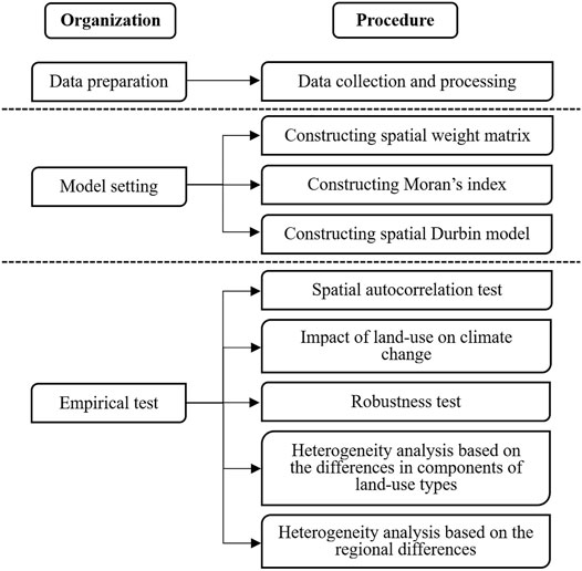
FIGURE 1. The methodological steps of this paper.
2.2 Data Sources
2.2.1 Dependent Variable
In this paper, the temperature anomaly is selected as the dependent variable to represent climate change. Temperature anomaly is one of the important variables used to measure climate change in scientific research, which a large number of climate studies has proved in the past (Huntingford and Cox, 2000; Lee and Ouarda, 2012; Bury et al., 2019). Compared with other variables measuring climate change (such as the absolute value of temperature), temperature anomaly has several advantages. One is the comparability of data. If the ordinary absolute value index is used to measure climate change, due to the differences of original geographical environment in various regions, there will be a false spatial spillover effect in spatial econometrics, and this error is difficult to be eliminated by control variables. The second is the availability of data. Climate change research is one of the critical points of environmental research. In the past, many kinds of indicators have been used to explain, such as temperature, precipitation, haze, and air pressure, but the temperature is always the main factor and has generally recognized data sources. Given a large number of national research samples in this paper, it is not easy to find an appropriate and complete variable to explain climate change, and the temperature anomaly meets these conditions. The time and space dimensions are 1990–2018 and 214 countries, respectively, and they are the same for the following independent variables and control variables. The temperature anomaly data, published by the Food and Agriculture Organization Corporate Statistical Database (FAOSTAT), are updated annually according to the national average land surface temperature change statistics. The data currently released cover the period from 1961 to 2020. Statistical data of monthly, seasonal, and annual mean temperature anomalies, i.e., the baseline climatological temperature changes corresponding to the period from 1951 to 1980, can be obtained. The standard deviation of the temperature change of the reference method can also be obtained. These data are based on the public GISTEMP data, i.e., the Global Surface Temperature Change data released by the National Aeronautics and Space Administration Goddard Institute for Space Studies (NASA-GISS). The GISS Surface Temperature Analysis (GISTEMP) is an estimate of global surface temperature change. Graphs and tables are updated around the middle of every month using current data files from NOAA GHCN v4 (meteorological stations) and ERSST v5 (ocean areas). These updated files incorporate reports for the previous month and also late reports and corrections for earlier months. The temperature anomaly data are from FAOSTAT, and there is no missing or artificial supplement. Figure 2 shows the annual average temperature anomalies of countries worldwide from 1990 to 2018 using the GeoDa software. In Figure 2, according to the decile method, the color depth is used to represent the distribution of temperature anomalies. The darker the color is, the greater the temperature change is. It can be seen that the temperature rise in northwest Africa, Europe and northern Asia is large, while that in southern Africa, South America and southern Asia is small.
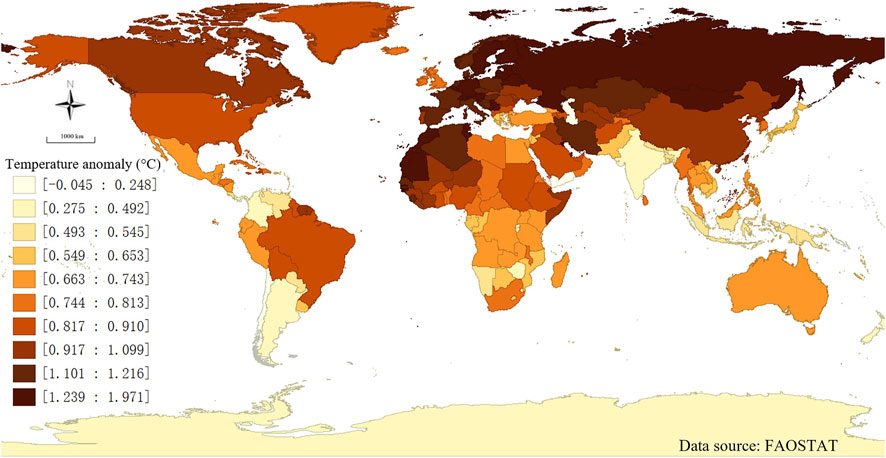
FIGURE 2. Average temperature anomalies from 1990 to 2018.
2.2.2 Independent Variables
In this paper, the proportion of different land-use in different countries is selected as the independent variable. Because of large area differences among countries, simply using the absolute value of land-use area can lead to strong data discrete trend and large heteroscedasticity, which is not in line with the overall goal of this paper to analyze the heterogeneity of land-use types. Therefore, this paper selects the ratio of land-use types to the total area of the country to represent land-use, making the comparison among countries more scientific and reasonable. The specific independent variables are the proportion of agricultural area, which can be decomposed into the proportion of arable land, the proportion of permanent crops, and the proportion of meadows and pasture land; as well as the proportion of forest area, which can be decomposed into the proportion of natural forest and the proportion of planted forest. The land-use area data comes from the United Nations Food and Agriculture Organization, with no missing and artificial supplements.
2.2.3 Control Variables
In this paper, six control variables are selected to control the social factors that affect climate except for land-use. They are GDP per land (100 USD/ha), population per land (1000 P/ha), capital stock per land (10 USD/ha), industrial added value as a percentage of GDP (%), CO2 emission per land (0.1 MM tons/ha) and energy consumption per land (quad Btu/ha). The above variables are ratios, and the reasons for selection are the same as those for independent variables. In addition, the first-order lag variable of temperature anomaly (°C) is controlled to exclude the lag effect caused by the previous year’s temperature. The above data are obtained from PWT10.0, United States Energy Information (EIA), and World Bank Database. A few missing data are supplemented by interpolation (Liu et al., 2019; Tapver, 2019; Zawadzki, 2020; Li et al., 2021a; Li et al., 2021b; Li et al., 2022a).
Table 1 lists the data sources of the major variables involved in this study. Table 2 shows the descriptive statistics of major variables in the study.
TABLE 1. Variable data source.
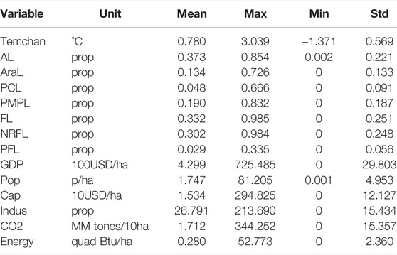
TABLE 2. Descriptive statistics.
2.3 Modelling Procedures
A panel data model is suitable for the analysis of correlations between observed samples in different periods (Li T et al., 2021; Li et al., 2021c; Li et al., 2021d; Li et al., 2022b). In this study, it is helpful to investigate the mechanism of land-use affecting climate change in 214 sample countries over for 40 years. The First Law of Geography, according to Waldo Tobler, (1970), is “everything is related to everything else, but near things are more related than distant things”. Climate change in adjacent areas is inherently related, and the change of land-use structure in a particular area may directly or indirectly affect the climate change in neighboring areas. Therefore, it is necessary to study the possible spatial spillover effects of land-use on climate change using the spatial panel model (Zhong and Li, 2020).
The first step is to test the spatial correlation of temperature changes. The most popular method to measure spatial autocorrelation is Moran’s I:
Where,
In the second step, to compare with the spatial panel model, a fixed panel data model without spatial effect is established:
In Eq. 2, the dependent variable
According to IPCC and other literature (Abiodun et al., 2012; Maimaitiyiming et al., 2014; Ipcc et al., 2018; Sayyadi et al., 2019), land-use in neighboring countries may also affect climate change in their own countries. Spatial Durbin model (SDM) is a combined extension of spatial lag and spatial error term model, which can be established by adding corresponding constraints to spatial lag model and spatial error model. In fact, SDM is a spatial lag model (SAR) enhanced by adding spatial lag variables. This is highly consistent with the spatial autocorrelation of variables in this paper, and we can get more effective conclusions. Therefore, In the third step, to demonstrate whether there is spillover and spatial correlation between land-use and climate change, this paper introduces the weighted term of the spatial weighting matrix of each variable as the explanatory variable and establishes a spatial Durbin model:
In Eq. 3,
After that, the robustness test, component heterogeneity and regional heterogeneity test are carried out by using the model of Eq. 3. In the robustness test, we adjust the bandwidth and type of
In the regional heterogeneity test, we only change the number of regression samples. In Section 4, the sample countries are categorized into high latitude group (111 countries with geographic center latitude higher than 60), middle latitude group (75 countries with geographic center latitude between 30 and 60), and low latitude group (28 countries with geographic center latitude lower than 30). The samples are also divided into island countries (45 island countries) and mainland countries (169 countries other than island countries) according to whether they are islands.
From the temperature change indicator in the third row of Table 3, we can see the heterogeneity of temperature change among samples. After grouping by latitude, the average temperature change of high latitude sample countries is 0.568°C; the average temperature change of middle latitude sample countries is 0.908°C, and that of low latitude sample countries is 0.747°C. In terms of land-sea difference, the average temperature change of island countries is 0.612°C, while that of non-island continent countries is 0.825°C.
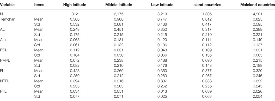
TABLE 3. Variable grouping statistics.
After grouping by latitude, it shows significant differences in land-use structure of sample countries in different groups in Table 3. Taking agricultural land as an example, the proportion of agricultural land in high-latitude countries is 24.8%, that in mid-latitude countries is 45.1%, and that in low-latitude countries is 35.2%. In terms of forest land, the proportion of forest land in high-latitude countries, mid-latitude countries and low-latitude countries is 42.8%, 26.9% and 35.0%, respectively. Generally speaking, high latitudes are cold, low latitudes are prone to drought, and middle latitudes are more suitable for crop growth. There are large coniferous forests and hot spot rain forests in high and low latitudes, respectively, which are the areas where natural forests are concentrated.
Considering that there is significant heterogeneity in the degree of climate change and the type of land-use in the sample countries after grouping, it is necessary to investigate whether there is inter-group heterogeneity in the mechanism of land-use impact on climate change.
3 Heterogeneity Analysis Based on the Differences of Land-Use Types
3.1 Spatial Autocorrelation Test of Temperature Change
Before analyzing the spatial effect of land-use on climate change, it is necessary to verify whether there is spatial autocorrelation of climate change in each sample country. In this paper, according to Eq. 1, the GeoDa software (GeoDa is a free software package that conducts spatial data analysis, geo-visualization, spatial autocorrelation, and spatial modeling) is used to establish the spatial weighting matrix based on the longitude and latitude distance (Anselin et al., 2006), and Moran’s I test (Moran’s I is a measure of spatial autocorrelation developed by Patrick Alfred Pierce Moran) is used to investigate the annual temperature change of all samples based on the distance spatial weight index (Moran, 1950; Li et al., 2007). The corresponding test results are shown in Figure 3, where the range bandwidth in the model is selected from 0–20.
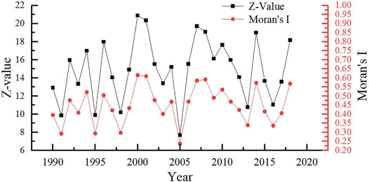
FIGURE 3. Moran’s I and Z-Value evolution of annual temperature change.
As can be seen from Figure 3, the spatial distribution of temperature changes in 214 countries over the past years is not random, but shows significant spatial correlation on the whole, and temperature changes have strong spatial dependence. The results show that the global Moran’s I values are all positive, between 0.236 and 0.615, and the Z-values are between 7.69 and 20.88, both of which pass the 1% significance test. Therefore, the spatial distribution of the temperature change levels has a significant positive global spatial auto-correlation during the study period, and the temperature change of the local country will be affected by that of its neighboring countries. This analysis conclusion is logical and in line with expectations. It is also consistent with the annual mean temperature anomaly of all countries in the world from 1990 to 2018 shown in Figure 2. The division mode of climatic zones does not coincide with the actual national boundaries, and the climate changes in adjacent areas are bound to have a variety of relationships, thus the climate types, direction, and degree of climate change are likely to be related. Based on this, the spatial econometric model can be used for model fitting and analysis after statistical testing.
3.2 Analysis of Benchmark Regression
Table 4 shows the regression results using the benchmark panel model without spatial effect according to Eq. 2 to test the impact of land-use on climate change. Because all empirical tests in this paper consider the first-order lag factor of temperature change, the actual regression sample is the 28-year data (i.e., 1991-2018) of 214 countries.
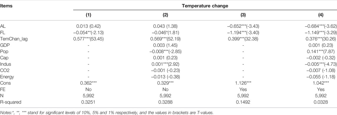
TABLE 4. Panel regression results without spatial effect.
According to Table 4, it can be found that after adding the lag term TemChan_lag of the dependent variable TemChan, the increase of the proportion of forest land has a significant effect on reducing the national temperature in all the analysis models, but in the analysis results of Columns (3) and (4) that control the individual random effect, the coefficients of the forest land proportion are larger and more significant. Under the condition of not controlling the individual random effect, the coefficients of the agricultural land proportion in Columns (1) and (2) are positive but not significant. If the individual random effect is controlled, the coefficients of agricultural land proportion in Columns (3) and (4) are negative and significant, that is to say, the increase of the proportion of the agricultural land will significantly reduce the temperature level of the country. Therefore, it can be seen that there are significant differences in the impacts of the change of agricultural land and forestry land on climate change, and the impacts of different land-use types on climate change are heterogeneous.
In Columns (1) and (2) without individual random effect control, the lag-term coefficient of the dependent variable
In the control variables of Table 4, when individual countries are not fixed, that is Column (2), the regression results largely reflect the horizontal comparison between countries. The first-order lag term of temperature change has a significant positive effect on the current temperature change (
3.3 Analysis of Spatial Durbin Model Regression
Next, according to Eq. 3, the regression of the spatial Durbin model is carried out to investigate the spatial correlation of land-use impact on climate change. According to Table 5, after adding the spatial weighting matrix, the fitting regression coefficients of
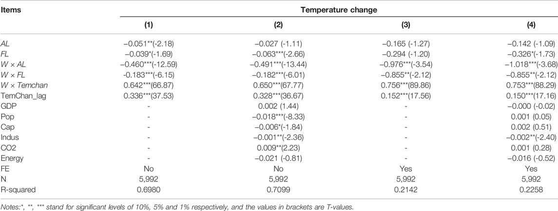
TABLE 5. The regression results of the spatial Durbin model.
Further observation shows that the impact of land-use on climate is heterogeneous in land-use types, that is, there are differences between the impact of domestic agricultural land structure adjustment and the impact of forestry land structure adjustment on its own temperature change. The same is true for that of agroforestry structure adjustment in surrounding areas. Specifically, first, in the analysis results shown in Column (4), the impact of agricultural land on climate change is not significant. In contrast, the increase of forestry land will significantly lead to the decrease of temperature (each 1% increase in the proportion of forestry land will reduce the temperature anomaly by 0.326°). This shows that the heterogeneity of the impact of land-use types on climate change exists. Second, the agricultural and forestry land of surrounding countries will significantly reduce domestic temperature. As we mentioned, the flow of carbon dioxide in the atmosphere and the climate change in nature are not bound by human society’s national boundaries. The adjustment of land-use structure in neighboring countries will lead to adjusting parameters in land and atmosphere feedback mechanism, affect local carbon dioxide cycle and temperature, and affect local climate change. The analysis results in Table 5 well reflect this phenomenon. Besides, the impact coefficient of the proportion of agricultural land of surrounding countries on the domestic temperature change (the coefficient is negative, the absolute value should be taken for comparison) is always greater than that of the proportion of forestry land of surrounding countries on the domestic temperature change. This indicates that the spatial spillover of land-use to climate change is also heterogeneous due to the difference in land-use types.
In the control variables of Table 5, when individual countries are not fixed, that is Column (2), the regression results reflect the horizontal comparison between countries. After considering the spatial effect, the first-order lag of temperature change still plays a significant role in promoting the current temperature change (
Compared with the empirical results without spatial effect, the regression results of the spatial Durbin model may be more reliable. First, from the model design perspective, factors affecting climate change, such as carbon dioxide, will flow between different regions, resulting in significant spatial autocorrelation of temperature change at the geographical level. Excluding the spatial effects will lead to the missing variable deviation, and the result may be unreliable. Second, From the perspective of fitting effect, the goodness of fit of the regression results of the spatial Durbin model is much better than the regression results without spatial effect. Third, from the perspective of empirical results, the empirical results in Table 5 are more reasonable. Figure 4 comprehensively shows the mechanism of the spatial affecting of land-use on the temperature change, and within the dotted line is the benchmark regression without spatial effect.
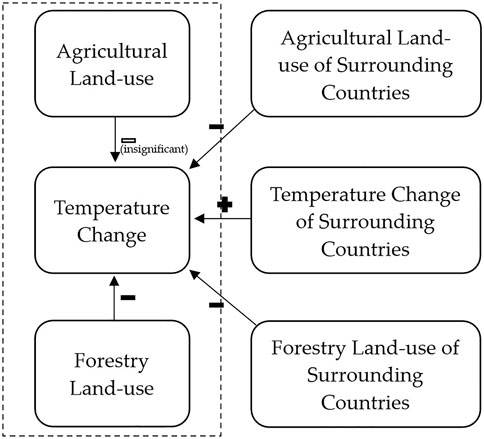
FIGURE 4. The spatial affecting mechanism of land-use on temperature change.
3.4 Robustness Test
Based on the spatial correlation test of land-use impact on climate change, the robustness test is carried out to investigate the influence of adjusting the distance bandwidth and the spatial weighting matrix type on the robustness of the analysis conclusion (Su et al., 2021). Table 6 shows all the empirical estimation results of the robustness test. The specific settings and analysis are described below.
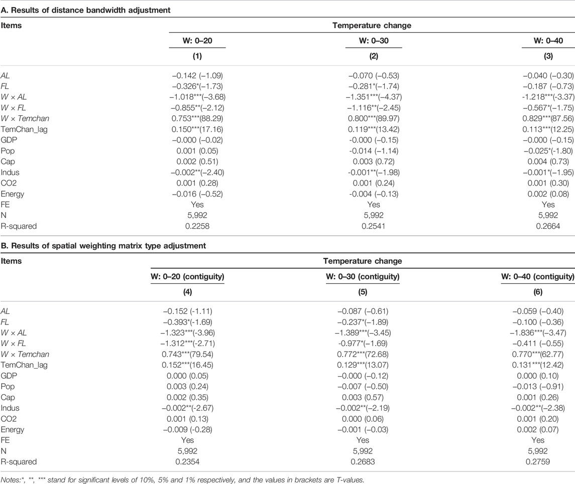
TABLE 6. Results of robustness test.
The first is the robustness test of distance bandwidth. For the theoretical model with spatial correlation analysis, the selection of distance bandwidth determines the number of neighboring countries, which may affect the test results of spatial effect. In order to test whether the adjustment of the distance band affects the robustness of the model analysis, the distance bandwidth is expanded from 0–20 to 0–30 and 0–40, respectively, as shown in Columns (1–3) of Table 6. At this time, the sample countries will have more neighbors to be included in the spatial matrix. It can be seen that the impact of land-use on climate change is not affected by the setting of distance bandwidth, and the analysis conclusion is robust.
The second is the robustness test of the contiguity spatial weighting matrix. The spatial weighting matrix is the critical parameter of the spatial panel data model. The setting method of spatial weighting matrix may affect the test results of spatial effect. In this part, the contiguity weighting matrix is used for the robustness test. The contiguity spatial weighting means that there is a distance dummy variable, when the distance between two samples is less than the set threshold, the distance dummy variable between them is regarded as a neighbor (i.e., 1); When the distance between them is greater than the set threshold, this distance dummy variable is regarded as not adjacent (i.e., 2). This setting is different from the direct distance calculation between the two countries, but the general idea is the same. The adjusted spatial weighting matrix in combination with different distance band settings is used to investigate the spatial correlation of land-use affecting climate change, and the analysis results are shown in Columns (4–6) of Table 6. As can be seen from the test results, adjusting the setting of the spatial weighting matrix does not affect the robustness of the analysis conclusion.
3.5 Additional Analysis: Heterogeneity Based on the Differences in Components of Land-Use Types
Considering that agricultural land can be divided into arable land, land under permanent crops and meadows and pasture land, and forest land can be divided into naturally regenerating forest land and planted forest land, thus we can further investigate the impact of land-use on climate change based on the subdivisions of agricultural and forestry land.
According to Figure 5, it can be found that the impact of land-use on climate change is still heterogeneous after land-use types are subdivided in the spatial Durbin model. The size of circles in Figure 5 is set according to the absolute values of the influence. The red and blue arrows represent the heating and cooling effect, respectively. The increase of arable land proportion
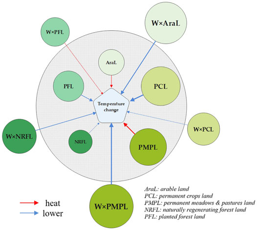
FIGURE 5. Spatial Durbin regression results of land type subdivision.
4 Heterogeneity Analysis Based on the Regional Differences
This section examines the regional heterogeneity of the impact of land-use on climate change. The general econometric model heterogeneity analysis usually divides the samples into developed and developing countries (Drissi and Boukhatem, 2020). In this paper, the biogeochemical and biophysical effects of land-use on climate change may be heterogeneous due to regional differences such as latitude, geographical distribution and hydrological characteristics, and the conclusions obtained by case studies of selected sample countries in existing literature may have sample bias due to regional heterogeneity. Next, the spatial Durbin model will be used to test whether there is significant regional heterogeneity in the impact of land-use on climate change.
Figure 6 shows the spatial Durbin model analysis results of the impact of land-use on climate change for the whole sample, high-latitude samples, middle-latitude samples, low-latitude samples, island country samples and mainland country samples based on Eq. 3. The part inside the dotted line is land-sea difference, and the part outside the dotted line is latitude difference. The size of pie charts in Figure 6 is set according to the absolute values of the influence.
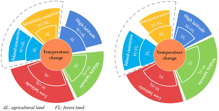
FIGURE 6. Spatial Durbin regression results for regional heterogeneity analysis.
Latitude difference will cause the heterogeneous impact of land-use on climate change. Taking the impact of agricultural land proportion on temperature change as an example, the increase of agricultural land proportion in high latitude countries
There is also heterogeneity in the impact of land-use structure adjustment on climate change in island countries and mainland countries. The increase in the proportion of agricultural land in island countries and mainland countries has no significant impact on the temperature change. However, the increase in the proportion of agricultural land in island countries will inhibit the temperature rise
5 Results and Discussion
On the basis of a comprehensive review of existing theories and literature, this paper uses the Moran’s I test (Eq. 1), benchmark model (Eq. 2) and spatial Durbin model (Eq. 3) to verify the heterogeneity of land-use impact on climate change in the two dimensions of type and region, based on the data of 214 countries from 1990 to 2018. The following empirical results are drawn: 1) According to the Moran’s I test results, we find that the temperature change shows significant spatial correlation, that is, it has a strong spatial dependence. 2) According to the benchmark and spatial Durbin test results, we find there is heterogeneity in the impacts of different land-use types on climate change. On the one hand, the impact of agricultural land on local climate change is small and not significant, but the increase of the proportion of forestry land can significantly inhibit the temperature rise in the local country. On the other hand, the growth of agricultural and forestry land in neighboring countries has significantly inhibited climate change in their own countries, and the inhibitory effect is greater than the change of land structure in their own countries. 3) The component heterogeneity test shows that local proportion of land under permanent crops and naturally regenerating forest land can significantly inhibit temperature changes, while the inhibitory effects of surrounding countries mainly come from arable land, land under permanent meadows and pastures and naturally regenerating forest land. 4) The regional heterogeneity test shows that there is heterogeneity in the impact of land-use on climate change between different latitudes and island and mainland countries.
From the empirical results and analysis, several important findings and implications can be summarized.
First, the impacts of different land-use types on climate change are heterogeneous. The impact of agricultural land on climate change is small and not significant, but the increase of the proportion of forestry land can significantly inhibit the temperature rise in the local country. To some extent, agricultural land comes from the conversion of forest land. The conversion from forest land to agricultural land is actually a carbon emission process because the forest has a much stronger carbon sequestration capacity than farmland. The increase of agricultural land may be from converting non-agricultural land to agricultural land, or from the conversion of forest land. Without understanding the internal conversion mechanism, the data shows that the increase of agricultural land and forest land will inhibit the rise of temperature. In contrast, the inhibitory effect of agricultural land is not significant, and the increase of forest land has a greater inhibitory effect. This conclusion provides experience for the land-use transformation now needed to address climate change.
Second, the impact of land-use on climate change has regional heterogeneity in the dimensions of latitude difference and land-sea difference. In terms of latitude difference, what worth noting is that, as shown in Table 3, the proportion of agricultural land in high latitude sample countries, middle latitude sample countries and low latitude sample countries is 24.8%, 45.1% and 35.2%, respectively, of which the proportion of agricultural land in high latitude countries is the lowest and significantly lower than that in the other two groups of sample countries. The proportion of forestry land in high latitude sample countries, middle latitude sample countries and low latitude sample countries is 42.8%, 26.9% and 35.0%, respectively. Among them, the proportion of forestry land in middle latitude sample countries is the lowest and significantly lower than that in the other two groups of sample countries. To a certain extent, this may explain why temperature change is more sensitive to the change of agricultural land proportion in high latitude countries and the change of forestry land proportion in mid latitude countries. After all, they have less basic shares, and their share change has a more noticeable impact on the adjustment of local land-use structure. In terms of land-sea difference, continent countries and neighboring countries share a land climate cycle system. The adjustment of land-use structure caused by the change of the proportion of agricultural land or forest land in neighboring countries will affect this system’s multiple biophysical and biogeochemical effects. Logically, island countries have no de facto neighbors, even if the geographical distance may be small. After all, it is the sea that borders the island countries. This conclusion provides a reference for the land-use policy of countries in specific regions.
Third, climate change in a country is affected by its own land-use structure and, more importantly, the land-use structure of neighboring countries. This phenomenon is logically reasonable. Temperature and climate change in nature are in an integrated form, and carbon dioxide can freely flow across borders in the atmosphere. Considering that the adjustment of agricultural or forestry land-use within a sample country represents the adjustment of land-use in a single country (which is much smaller than the adjustment of land-use in neighboring countries or regions) represents the whole world. Therefore, it is reasonable that the adjustment of agroforestry land structure in neighboring countries significantly affects the climate change of a country so that the effect exceeds the effect of the adjustment of local land-use structure. This conclusion reinforces the importance of international cooperation on climate and environment.
Admittedly, this study also has several shortcomings. 1) Although the proposed heterogeneous impact of land-use type provides a guideline for agroforestry climate policy, the impact is dependent on the sample data and the mathematical reasoning proof, lacking the in-depth natural science analysis. This issue may limit the long-term validity of the results in the future and merely reflect the facts of what happened in the past. In future research, more datasets should be used to verify its effectiveness. 2) It should be noted that there are some large countries in the sample (such as Russia, the United States, and China), and they almost have no “neighbors” in the model. For a country with a very large area, the distance between its geographical center and its boundary is very far, so few neighbors are at the distance threshold of 0–20. Even at the distance threshold of 0–30 and 0–40, these large countries have few neighbors. Therefore, in the regression of the spatial Durbin model, the impact of land-use in neighboring countries on their own climate change is hardly considered. In fact, this is just in line with the actual situation. When considering the relation of land-use and climate change, countries with a large area have certain particularities. They have a vast territory so that their climate change basically depends on their own characteristics and is not affected by the small neighboring countries. This means that future models should strive to achieve the ability to identify specific samples. 3) The main estimation method of spatial econometric model is MLE (Maximum likelihood estimate), but the large sample theory of MLE needs to be improved. Spatial metrology also requires researchers to set a non-random spatial weight matrix (rather than estimating this matrix based on data), so this spatial weight matrix may not fully reflect the complex relationship between different regions. 4) In the additional analysis, the proportion of subdivided types of land will further decrease (the proportion of arable land must be less than that of agricultural land, while the proportion of natural forest land must be less than that of forest land), and the direction of the transformation of different subdivided types of land is unclear (the increase of planted forest land may be at the cost of occupying wasteland or arable land, or at the cost of occupying natural forest land). Therefore, it is not easy to understand or explain the fitting model results based on the data of subdivided land-use structure change. It is necessary to further clarify the internal mechanism of land-use subdivision type. We plan to examine these issues in the future.
Overall, this study analyzes the impact of land-use on climate change through quantitative methods, and the relevant conclusions can provide a reference for proposing international initiatives to address climate change or establishing an international convention to address climate change. From the perspective of land-use, effective measures should be taken to prevent deforestation and over-exploitation of agricultural land. From the perspective of location differences, countries with different geographical distribution conditions should specify land and climate policies according to local conditions. From the perspective of international climate relations, it is necessary for all countries to abandon the narrow thinking of “zero-sum game” and share more and play more to the inhibitory effect of green land-use on global warming, so as to realize the great ideal of mutual benefit and win-win results.
Data Availability Statement
The original contributions presented in the study are included in the article/Supplementary Material, further inquiries can be directed to the corresponding author.
Author Contributions
SJ, CY, MW, and PF contributed to conception and design of the study. SJ and CY organized the database. SJ and CY performed the statistical analysis. SJ, CY, MW, and PF wrote the first draft of the manuscript. SJ, CY, MW, and PF wrote sections of the manuscript. All authors contributed to manuscript revision, read, and approved the submitted version.
Funding
This research was funded by the National Social Science Fund of China (21CTJ013).
Conflict of Interest
The authors declare that the research was conducted in the absence of any commercial or financial relationships that could be construed as a potential conflict of interest.
Publisher’s Note
All claims expressed in this article are solely those of the authors and do not necessarily represent those of their affiliated organizations or those of the publisher, the editors, and the reviewers. Any product that may be evaluated in this article, or claim that may be made by its manufacturer, is not guaranteed or endorsed by the publisher.
References
Abiodun, B. J., Adeyewa, Z. D., Oguntunde, P. G., Salami, A. T., and Ajayi, V. O. (2012). Modeling the Impacts of Reforestation on Future Climate in West Africa. Theor. Appl. Climatol. 110, 77–96. doi:10.1007/s00704-012-0614-1
Allen, R. J., Hassan, T., Randles, C. A., and Su, H. (2019). Enhanced Land-Sea Warming Contrast Elevates Aerosol Pollution in a Warmer World. Nat. Clim. Chang. 9, 300, 305. doi:10.1038/s41558-019-0401-4
Anselin, L., Syabri, I., and Kho, Y. (2006). GeoDa: An Introduction to Spatial Data Analysis. Geographical Anal. 38, 5–22. doi:10.1111/j.0016-7363.2005.00671.x
Arora, V. K., and Montenegro, A. (2011). Small Temperature Benefits provided by Realistic Afforestation Efforts. Nat. Geosci. 4, 514–518. doi:10.1038/ngeo1182
Avitabile, V., Herold, M., Heuvelink, G. B. M., Lewis, S. L., Phillips, O. L., Asner, G. P., et al. (2016). An Integrated pan‐Tropical Biomass Map Using Multiple Reference Datasets. Glob. Change Biol. 22, 1406–1420. doi:10.1111/gcb.13139
Azadi, H., Taheri, F., Burkart, S., Mahmoudi, H., De Maeyer, P., and Witlox, F. (2021). Impact of Agricultural Land Conversion on Climate Change. Environ. Dev. Sustain. 23, 3187–3198. doi:10.1007/s10668-020-00712-2
Benzie, M., and Persson, Å. (2019). Governing Borderless Climate Risks: Moving beyond the Territorial Framing of Adaptation. Int. Environ. Agreements. 19, 369–393. doi:10.1007/s10784-019-09441-y
Berckmans, J., Hamdi, R., and Dendoncker, N. (2019). Bridging the Gap Between Policy‐Driven Land Use Changes and Regional Climate Projections. J. Geophys. Res. Atmos. 124, 5934–5950. doi:10.1029/2018jd029207
Boone, A. A., Xue, Y., De Sales, F., Comer, R. E., Hagos, S., Mahanama, S., et al. (2016). The Regional Impact of Land-Use Land-Cover Change (LULCC) Over West Africa from an Ensemble of Global Climate Models Under the Auspices of the WAMME2 Project. Clim. Dyn. 47, 3547–3573. doi:10.1007/s00382-016-3252-y
Brentrup, J. A., Richardson, D. C., Carey, C. C., Ward, N. K., Bruesewitz, D. A., and Weathers, K. C. (2021). Under-ice Respiration Rates Shift the Annual Carbon Cycle in the Mixed Layer of an Oligotrophic lake from Autotrophy to Heterotrophy. Inland Waters. 11, 114–123. doi:10.1080/20442041.2020.1805261
Bury, T. M., Bauch, C. T., and Anand, M. (2019). Charting Pathways to Climate Change Mitigation in a Coupled Socio-Climate Model. Plos Comput. Biol. 15, e1007000. doi:10.1371/journal.pcbi.1007000
Byrne, M. P., and O’Gorman, P. A. (2013). Land-Ocean Warming Contrast over a Wide Range of Climates: Convective Quasi-Equilibrium Theory and Idealized Simulations. J. Clim. 26, 4000–4016. doi:10.1175/jcli-d-12-00262.1
Byrne, M. P., and O’Gorman, P. A. (2018). Trends in continental Temperature and Humidity Directly Linked to Ocean Warming. Proc. Natl. Acad. Sci. U.S.A. 115, 4863–4868. doi:10.1073/pnas.1722312115
Cho, S. J., and Mccarl, B. (2021). Major United States Land Use as Influenced by an Altering Climate: A Spatial Econometric Approach. Land 10, 546. doi:10.3390/land10050546
Collalti, A., Tjoelker, M. G., Hoch, G., Mäkelä, A., Guidolotti, G., Heskel, M., et al. (2020). Plant Respiration: Controlled by Photosynthesis or Biomass? Glob. Change Biol. 26, 1739–1753. doi:10.1111/gcb.14857
Dirmeyer, P. A., Niyogi, D., de Noblet-Ducoudré, N., Dickinson, R. E., and Snyder, P. K. (2010). Impacts of Land Use Change on Climate. Int. J. Climatol. 30, 1905–1907. doi:10.1002/joc.2157
Dong, N., Luo, M., Liu, Z., Sun, J., Wu, K., and Lin, H. (2021). The Roles of Leaf Area index and Albedo in Vegetation Induced Temperature Changes across China Using Modelling and Observations. Clim. Dyn. doi:10.1007/s00382-021-06028-9
Drissi, R., Boukhatem, J., and Boukhatem, J. (2020). A Nonlinear Adjustment in Real Exchange Rates under Transaction Costs Hypothesis in Developed and Emerging Countries. Quantitative Finance Econ. 4, 220–235. doi:10.3934/qfe.2020010
Forzieri, G., Alkama, R., Miralles, D. G., and Cescatti, A. (2017). Satellites Reveal Contrasting Responses of Regional Climate to the Widespread Greening of Earth. Science. 356, 1180–1184. doi:10.1126/science.aal1727
Fujita, T., Ariga, T., Ohashi, H., Hijioka, Y., and Fukasawa, K. (2019). Assessing the Potential Impacts of Climate and Population Change on Land-Use Changes Projected to 2100 in Japan. Clim. Res. 79, 139–149. doi:10.3354/cr01580
Getis, A., and Aldstadt, J. (2004). Constructing the Spatial Weights Matrix Using a Local Statistic. Geographical Anal. 36, 90–104. doi:10.1111/j.1538-4632.2004.tb01127.x
Gries, T., Redlin, M., and Ugarte, J. E. (2019). Human-induced Climate Change: the Impact of Land-Use Change. Theor. Appl. Climatol 135, 1031–1044. doi:10.1007/s00704-018-2422-8
Haque, N., Rashid, S., and Rashid, S. (2019). Host Country Characteristics Attracting Climate Projects through Public-Private Partnerships. Green. Finance. 1, 405–428. doi:10.3934/gf.2019.4.405
Hartley, A. J., Parker, D. J., Garcia-Carreras, L., and Webster, S. (2016). Simulation of Vegetation Feedbacks on Local and Regional Scale Precipitation in West Africa. Agric. For. Meteorology. 222, 59–70. doi:10.1016/j.agrformet.2016.03.001
Hedlund, J., Fick, S., Carlsen, H., and Benzie, M. (2018). Quantifying Transnational Climate Impact Exposure: New Perspectives on the Global Distribution of Climate Risk. Glob. Environ. Change. 52, 75–85. doi:10.1016/j.gloenvcha.2018.04.006
Huntingford, C., and Cox, P. M. (2000). An Analogue Model to Derive Additional Climate Change Scenarios from Existing GCM Simulations. Clim. Dyn. 16, 575–586. doi:10.1007/s003820000067
Ipcc Stocker, T., Qin, D., Plattner, G.-K., Tignor, M., Allen, S. K., Boschung, J., et al. (2013). The Physical Science Basis. Contribution of Working Group I to the Fifth Assessment Report of the Intergovernmental Panel on Climate Change. Clim. Change. 2013, 1–1552.
Ipcc Masson-Delmotte, V., Zhai, P., Pörtner, H.-O., Roberts, D., Skea, J., Shukla, P., et al. (2018). Global Warming of 1.5°C. An IPCC Special Report on the Impacts of Global Warming of 1.5°C above Pre-industrial Levels and Related Global Greenhouse Gas Emission Pathways, in the Context of Strengthening the Global Response to the Threat of Climate Change, Sustainable Development, and Efforts to Eradicate Poverty. IPCC.
Jeong, D. I., and Sushama, L. (2019). Projected Changes to Mean and Extreme Surface Wind Speeds for North America Based on Regional Climate Model Simulations. Atmosphere 10, 497. doi:10.3390/atmos10090497
Jia, S., Dong, H., and Yang, H. (2021). Asymmetric Risk Spillover of the International Crude Oil Market in the Perspective of Crude Oil Dual Attributes. Front. Environ. Sci. 9, 335. doi:10.3389/fenvs.2021.720278
Kanter, D., Alcamo, J., Sutton, M., Davidson, E., and Sharma, P. (2013). Drawing Down N2O to Protect Climate and the Ozone Layer: A UNEP Synthesis Report. Nairobi: United Nations Environment Programme.
Kemena, T. P., Matthes, K., Martin, T., Wahl, S., and Oschlies, A. (2018). Atmospheric Feedbacks in North Africa from an Irrigated, Afforested Sahara. Clim. Dyn. 50, 4561–4581. doi:10.1007/s00382-017-3890-8
Klein, C., Bliefernicht, J., Heinzeller, D., Gessner, U., Klein, I., and Kunstmann, H. (2017). Feedback of Observed Interannual Vegetation Change: a Regional Climate Model Analysis for the West African Monsoon. Clim. Dyn. 48, 2837–2858. doi:10.1007/s00382-016-3237-x
Lee, T., and Ouarda, T. B. M. J. (2012). An EMD and PCA Hybrid Approach for Separating Noise from Signal, and Signal in Climate Change Detection. Int. J. Climatol. 32, 624–634. doi:10.1002/joc.2299
Lehner, F., Deser, C., and Sanderson, B. M. (2018). Future Risk of Record-Breaking Summer Temperatures and its Mitigation. Climatic Change 146, 363–375. doi:10.1007/s10584-016-1616-2
Lejeune, Q., Davin, E. L., Guillod, B. P., and Seneviratne, S. I. (2015). Influence of Amazonian Deforestation on the Future Evolution of Regional Surface Fluxes, Circulation, Surface Temperature and Precipitation. Clim. Dyn. 44, 2769–2786. doi:10.1007/s00382-014-2203-8
Lejeune, Q., Davin, E., Gudmundsson, L., Winckler, J., and Seneviratne, S. (2018). Historical Deforestation Locally Increased the Intensity of Hot Days in Northern Mid-latitudes. Nat. Clim. Change. 8, 386. doi:10.1038/s41558-018-0131-z
Li, X., and Bo, T. (2019). Statistics and Spectra of Turbulence under Different Roughness in the Near‐neutral Atmospheric Surface Layer. Earth Surf. Process. Landforms. 44, 1460–1470. doi:10.1002/esp.4588
Li, H., Calder, C. A., and Cressie, N. (2007). Beyond Moran's I: Testing for Spatial Dependence Based on the Spatial Autoregressive Model. Geographical Anal. 39, 357–375. doi:10.1111/j.1538-4632.2007.00708.x
Li, M., Cui, Y., Fu, Y., Li, N., Tang, X., Liu, X., et al. (2020). Simulating the Potential Sequestration of Three Major Greenhouse Gases in China's Natural Ecosystems. Forests. 11, 128. doi:10.3390/f11020128
Li, F., Yang, C., Li, Z., and Failler, P. (2021). Does Geopolitics Have an Impact on Energy Trade? Empirical Research on Emerging Countries. Sustainability. 13, 5199. doi:10.3390/su13095199
Li, T., Li, X., and Liao, G. (2021). Business Cycles and Energy Intensity. Evidence from Emerging Economies. Borsa Istanbul Rev. doi:10.1016/j.bir.2021.07.005
Li, Z., Ao, Z. M., and Mo, B. (2021a). Revisiting the Valuable Roles of Global Financial Assets for International Stock Markets: Quantile Coherence and Causality-In-Quantiles Approaches. Mathematics. 9, 1750. doi:10.3390/math9151750
Li, Z., Chen, L., and Dong, H. (2021b). What Are Bitcoin Market Reactions to Its-Related Events? Int. Rev. Econ. Finance 73, 1–10. doi:10.1016/j.iref.2020.12.020
Li, Z., Zou, F. Q., Tan, Y., and Zhu, J. H. (2021c). Does Financial Excess Support Land Urbanization-An Empirical Study of Cities in China. Land 10, 635. doi:10.3390/land10060635
Li, Z., Zou, F. Q., and Mo, B. (2021d). Does Mandatory CSR Disclosure Affect enterprise Total Factor Productivity? Econ. Research-Ekonomska Istrazivanja.
Li, Z., Dong, H., Floros, C., Charemis, A., and Failler, P. (2022a). Re-examining Bitcoin Volatility: A CAViaR-Based Approach. Emerging Markets Finance and Trade 58, 1320–1338. doi:10.1080/1540496x.2021.1873127
Li, Z. H., Huang, Z. M., and Failler, P. (2022b). Dynamic Correlation between Crude Oil Price and Investor Sentiment in China: Heterogeneous and Asymmetric Effect. Energies 15, 687. doi:10.3390/en15030687
Liu, Y., Zheng, Y., Zheng, Y., and M Drakeford, B. (2019). Reconstruction and Dynamic Dependence Analysis of Global Economic Policy Uncertainty. Quantitative Finance Econ. 3, 550–561. doi:10.3934/qfe.2019.3.550
Lopez, H., West, R., Dong, S., Goni, G., Kirtman, B., Lee, S.-K., et al. (2018). Early Emergence of Anthropogenically Forced Heat Waves in the Western United States and Great Lakes. Nat. Clim Change 8, 414, 420-+.doi:10.1038/s41558-018-0116-y
Ma, D., Notaro, M., Liu, Z., Chen, G., and Liu, Y. (2013). Simulated Impacts of Afforestation in East China Monsoon Region as Modulated by Ocean Variability. Clim. Dyn. 41, 2439–2450. doi:10.1007/s00382-012-1592-9
Maimaitiyiming, M., Ghulam, A., Tiyip, T., Pla, F., Latorre-Carmona, P., Halik, Ü., et al. (2014). Effects of green Space Spatial Pattern on Land Surface Temperature: Implications for Sustainable Urban Planning and Climate Change Adaptation. Isprs J. Photogrammetry Remote Sensing 89, 59–66. doi:10.1016/j.isprsjprs.2013.12.010
Mcguire, A. D., Lawrence, D. M., Koven, C., Clein, J. S., Burke, E., Chen, G., et al. (2018). Dependence of the Evolution of Carbon Dynamics in the Northern Permafrost Region on the Trajectory of Climate Change. Proc. Natl. Acad. Sci. U.S.A. 115, 3882–3887. doi:10.1073/pnas.1719903115
Moran, P. A. P. (1950). Notes on Continuous Stochastic Phenomena. Biometrika 37, 17–23. doi:10.1093/biomet/37.1-2.17
Nong, D. H., Ngo, A. T., Nguyen, H. P. T., Nguyen, T. T., Nguyen, L. T., and Saksena, S. (2021). Changes in Coastal Agricultural Land Use in Response to Climate Change: An Assessment Using Satellite Remote Sensing and Household Survey Data in Tien Hai District, Thai Binh Province, Vietnam. Land 10, 627. doi:10.3390/land10060627
Parks, S. A., Carroll, C., Dobrowski, S. Z., and Allred, B. W. (2020). Human Land Uses Reduce Climate Connectivity across North America. Glob. Change Biol. 26, 2944–2955. doi:10.1111/gcb.15009
Prestele, R., Arneth, A., Bondeau, A., de Noblet-Ducoudré, N., Pugh, T. A. M., Sitch, S., et al. (2017). Current Challenges of Implementing Anthropogenic Land-Use and Land-Cover Change in Models Contributing to Climate Change Assessments. Earth Syst. Dynam. 8, 369–386. doi:10.5194/esd-8-369-2017
Sayyadi, F., Moghaddasi, R., and Yazdani, S. (2019). How Climate Change Affects Land Use Pattern: An Iranian Provincial Experience. Int. J. Environ. Res. 13, 67–75. doi:10.1007/s41742-018-0151-6
Searchinger, T. D., Wirsenius, S., Beringer, T., and Dumas, P. (2018). Assessing the Efficiency of Changes in Land Use for Mitigating Climate Change. Nature 564, 249, 253-+.doi:10.1038/s41586-018-0757-z
Sejas, S. A., Albert, O. S., Cai, M., and Deng, Y. (2014). Feedback Attribution of the Land-Sea Warming Contrast in a Global Warming Simulation of the NCAR CCSM4. Environ. Res. Lett. 9, 124005. doi:10.1088/1748-9326/9/12/124005
Solana, J. (2020). Climate Change Litigation as Financial Risk. Green. Finance 2, 344–372. doi:10.3934/gf.2020019
Spracklen, D. V., and Garcia-Carreras, L. (2015). The Impact of Amazonian Deforestation on Amazon basin Rainfall. Geophys. Res. Lett. 42, 9546–9552. doi:10.1002/2015gl066063
Su, Y., Li, Z., and Yang, C. (2021). Spatial Interaction Spillover Effects between Digital Financial Technology and Urban Ecological Efficiency in China: An Empirical Study Based on Spatial Simultaneous Equations. Int. J. Environ. Res. Public Health. 18, 8535. doi:10.3390/ijerph18168535
Tabari, H., and Willems, P. (2018). More Prolonged Droughts by the End of the century in the Middle East. Environ. Res. Lett. 13. doi:10.1088/1748-9326/aae09c
Tapver, T. (2019). CSR Reporting in banks: Does the Composition of the Board of Directors Matter? Quantitative Finance Econ. 3, 286–314. doi:10.3934/qfe.2019.2.286
Tobler, W. (1970). A Computer Movie Simulating Urban Growth in the Detroit Region. Econ. Geogr. 46, 234–240. doi:10.2307/143141
Toelle, M. H., Engler, S., and Panitz, H.-J. (2017). Impact of Abrupt Land Cover Changes by Tropical Deforestation on Southeast Asian Climate and Agriculture. J. Clim. 30, 2587–2600. doi:10.1175/JCLI-D-16-0131.1
Tong, K., Liu, A., and Liu, A. (2020). Modeling Temperature and Pricing Weather Derivatives Based on Subordinate Ornstein-Uhlenbeck Processes. Green. Finance 2, 1–19. doi:10.3934/gf.2020001
Wallace, C. J., and Joshi, M. (2018). Comparison of Land-Ocean Warming Ratios in Updated Observed Records and CMIP5 Climate Models. Environ. Res. Lett. 13, 114011. doi:10.1088/1748-9326/aae46f
Wu, M., Schurgers, G., Ahlstrom, A., Rummukainen, M., Miller, P. A., Smith, B., et al. (2017). Impacts of Land Use on Climate and Ecosystem Productivity over the Amazon and the South American Continent. Environ. Res. Lett. 12, 054016. doi:10.1088/1748-9326/aa6fd6
Yang, C., Li, T., and Albitar, K. (2021). Does Energy Efficiency Affect Ambient PM2.5? The Moderating Role of Energy Investment. Front. Environ. Sci. 9, 707751. doi:10.3389/fenvs.2021.707751
Zawadzki, K. (2020). The Performance of ETFs on Developed and Emerging Markets with Consideration of Regional Diversity. Quantitative Finance Econ. 4, 515–525. doi:10.3934/qfe.2020024
Zhang, Q., Yang, Z., Hao, X., and Yue, P. (2019). Conversion Features of Evapotranspiration Responding to Climate Warming in Transitional Climate Regions in Northern China. Clim. Dyn. 52, 3891–3903. doi:10.1007/s00382-018-4364-3
Zhong, J., and Li, T. (2020). Impact of Financial Development and its Spatial Spillover Effect on Green Total Factor Productivity: Evidence from 30 Provinces in China. Math. Probl. Eng., 2020. doi:10.1155/2020/5741387
Keywords: land-use, climate change, heterogeneity, spatial durbin model, latitude
Citation: Jia S, Yang C, Wang M and Failler P (2022) Heterogeneous Impact of Land-Use on Climate Change: Study From a Spatial Perspective. Front. Environ. Sci. 10:840603. doi: 10.3389/fenvs.2022.840603
Received: 22 December 2021; Accepted: 11 April 2022;
Published: 27 April 2022.
Edited by:
Ioan Cristian Ioja, University of Bucharest, RomaniaReviewed by:
Mihai Razvan Nita, University of Bucharest, RomaniaAkbar Rahimi, University of Tabriz, Iran
Copyright © 2022 Jia, Yang, Wang and Failler. This is an open-access article distributed under the terms of the Creative Commons Attribution License (CC BY). The use, distribution or reproduction in other forums is permitted, provided the original author(s) and the copyright owner(s) are credited and that the original publication in this journal is cited, in accordance with accepted academic practice. No use, distribution or reproduction is permitted which does not comply with these terms.
*Correspondence: Mengxin Wang, wangmx2016@163.com