 Chiara Arrighi
- Department of Civil and Environmental Engineering, Università degli Studi di Firenze, Florence, Italy
Floods can significantly affect Cultural Heritage with consequences that might not easily be repaired, given the unicity of this type of exposed asset. Flood losses are both tangible and intangible since communities rely on cultural heritage for its historical, spiritual, aesthetic, and socio-economic values. This work aims at examining river flood risk of UNESCO tangible World Heritage (UNWH) sites to identify the most at risk assets with a risk matrix approach entailing hazard, exposure, and vulnerability at a global scale. A distinction is made between natural sites, for which only hazard and exposure are assessed, and cultural and mixed sites. Hazard is evaluated by using the river flood maps at global scale developed by JRC for six probabilistic scenarios, exposure classification is based on the World Heritage List selection criteria and vulnerability is based on site typology. The analysis on 1,121 sites, as of March 2021, shows that 35% of natural and 21% of cultural and mixed UNWH sites are exposed to river floods. The risk matrix combining hazard, exposure, and vulnerability reveals that 2% of UNWH is at extremely high risk and 7% at very high risk, mostly in the Europe-North America and Asia-Pacific Regions. The analysis also stresses the need for a systematic collection, update, and storage of georeferenced data for cultural heritage. Further analysis should be carried out at local scales, with a priority for higher risk sites to better estimate hazard and vulnerability at a higher spatial resolution.
Introduction
Floods are among the costliest natural hazards (CRED, 2015) and in some regions of the world there is a strong evidence that river flood hazard will increase due to climate change (Merz et al., 2021). Flood risk results from the combination of three components, hazard, vulnerability, and exposure, shaped by human-river interactions (Barendrecht et al., 2017). The growing need of managing and mitigating flood risk has fostered research about the evaluation of potential flood damages in the last decades which produced numerous vulnerability models (Gerl et al., 2016; Huizinga et al., 2017). Vulnerability models have been developed and applied for most of exposed assets, such as infrastructures (Michielsen et al., 2016; Pregnolato et al., 2017; Habermann and Hedel, 2018), buildings (Thieken et al., 2008; Cammerer et al., 2013; Carisi et al., 2018; Amadio et al., 2019; Molinari et al., 2020), agriculture (Brémond and Grelot, 2013; Molinari et al., 2019) and population (Jonkman, 2007; Di Mauro et al., 2012; Yari et al., 2020) just to cite a few examples. Vulnerabilities are then transformed into direct monetary losses by using reconstruction or market values of the exposed assets.
However, flood impacts on cultural and natural heritage remain little explored by research in contrast with the growing concerns related to climate change (Fatorić and Seekamp, 2017; Sesana et al., 2021).
A UNESCO World Heritage site is a landmark or area with an outstanding value for humanity, protected by an international convention (UNESCO, 1972). It is characterized by unicity and integrity and satisfies one or more eligibility criteria representing the extraordinary culmination of world cultural heritage. Natural heritage consists of sites, features, or geological and physiographical formations of outstanding universal value from the point of view of science, conservation, or natural beauty (UNESCO, 1972). Cultural heritage is broadly classified as either tangible, i.e., consisting of buildings, historic places, monuments etc., or intangible, i.e., referring to oral traditions, performing arts, social practices, rituals etc. (Stanton-Geddes and Soz, 2017). Henceforth the term cultural heritage will refer to tangible cultural heritage. Mixed sites are also listed by UNESCO. They are a combination of natural landscape/environment and built heritage such as landscapes shaped by livelihood and ceremonial traditions.
Moreover, cultural heritage is a significant damage hotspot for natural hazards in which (i) the direct tangible losses can be irreversible or might take decades to be repaired, (ii) the intangible losses, i.e., historical, spiritual, aesthetic, and social values affected, often lead to indirect economic losses, including loss of livelihoods (Stanton-Geddes and Soz, 2017; Appiotti et al., 2020). Although valuing cultural heritage is possible through principles of applied economy such as the travel cost method, hedonic price method or willingness to pay (Navrud and Ready, 2002; Del Saz Salazar and Montagud Marques, 2005; Sayce et al., 2009; Bajçinovci and Thaçi, 2016; Voltaire et al., 2017), the value obtained is not suitable to determine a restoration or reconstruction cost usually adopted in flood damage assessment. Moreover, such methods are usually applied to a single site because they require local data, e.g., surveys or expert judgement (Rolfe and Windle, 2003; Ankersmit and Stappers, 2017). These challenging aspects and the difficulties in transferring existing vulnerability models to cultural assets make flood risk assessment rarely applied.
Flood risk of cultural heritage has been recently analyzed at regional scale in Spain and at national scale in Portugal with a semi-quantitative approach based on hazard maps and vulnerability classification of heritage typology (Figueiredo et al., 2019; Garrote et al., 2020). At site scale, a flood risk framework has been applied to the historical city of Alzira (Spain) with a detailed catalog of morphological and constructive characteristics of monuments (Trizio et al., 2021). Asset-specific, component-based flood vulnerability functions have been developed for two churches in Portugal (Figueiredo et al., 2021).
Few works in literature describe flood risk analysis of UNWH sites. The Ayutthaya region in Thailand affected by a flood in 2011 has been studied by several authors who investigated current risk and mitigation strategies (Daungthima and Hokao, 2013; Vojinovic et al., 2016, 2021). Flood risk has been evaluated in the historical center of Florence, Italy (Arrighi et al., 2018a) and Guimaraes, Portugal (Miranda and Ferreira, 2019). The Sucevita catchment (Romania), which hosts UNWH monasteries, was examined to understand flood susceptibility of monuments (Hapciuc et al., 2016). Debris flow hazard for the site of Villa Romana del Casale (Italy) has been evaluated through catchment scale simulations of different scenarios of sediment mobilization and pluviometry curves (Musumeci et al., 2021). At larger scales, the effects of sea level rise have been investigated (Marzeion and Levermann, 2014), and only in the Mediterranean 49 UNWH sites are in low-lying areas potentially affected by coastal flooding or coastal erosion (Reimann et al., 2018). Therefore, exposure, vulnerability, and risk of UNWH sites to river floods at large scales have not been examined yet, and a general first-level spatial overview of potential risks is currently lacking.
As recently highlighted by Orr et al. (2021) the number of studies in the field of cultural heritage and climate change is increasing, however literature is dominated by the USA and Europe which examine their respective heritage. Methodological issues, regulatory challenges, and lack of understanding of climate change impacts are identified as the main barriers to this kind of studies, nevertheless, benefits of research on this topic are evident for an integrated understanding of systems, resilience and sustainability, and community engagement.
This work aims at understanding river flood risk of UNWH cultural and mixed sites for present climate by means of a risk matrix approach in which hazard, exposure, and vulnerability are explicitly assessed in a qualitative expert-based way. For natural heritage only flood hazard and exposure are evaluated. With respect to other works in literature, this work adopts a global scale for river flood risk analysis and introduces a proxy variable for ranking exposure value, which is not usually addressed in flood risk assessment of cultural heritage. Moreover, the georeferenced elaborations and results of this research are provided as open data in the Supplementary Material to be reused by researchers and practitioners also for other purposes, such as landslide or seismic risk analyses. The analysis is also used to discuss the issues related to exposure data availability and reliability which need to be addressed in future to increase the understanding of impacts and promote the inclusion of cultural heritage in climate change adaptation plans.
Materials and Methods
The method is based on the geospatial analysis of layers (see section Open Geospatial Datasets) providing information about river flood hazard and UNWH sites. Figure 1 summarizes the methodological workflow, data flows (gray boxes), and activities (ellipses). First, based on attribute information, UNWH sites are split into (i) natural and (ii) cultural/mixed. Mixed sites are a combination of natural landscape/environment and built heritage such as landscapes shaped by livelihood and ceremonial traditions. Hazard and exposure analysis are carried out for both types of sites (sections Hazard and Exposure Analysis of UNWH Sites, Exposure and Vulnerability Analysis of UNWH Sites) and the procedure ends here for natural ones. For cultural/mixed sites vulnerability is classified according to site typology (section Exposure and Vulnerability Analysis of UNWH Sites). Risk is obtained by combining hazard, exposure, and vulnerability classes, through a risk matrix application.
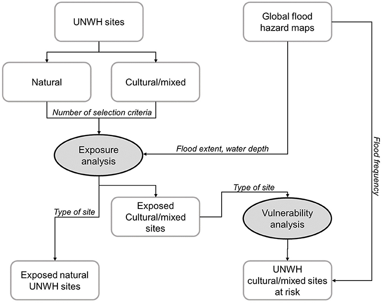
Figure 1. Methodological workflow for risk analysis of UNWH sites (ellipses stand for activities, boxes for data flow).
Open Geospatial Datasets
River flood hazard data at global scale are developed by the Joint Research Center (JRC) of the European Commission (Dottori et al., 2016). The data are openly available at the JRC Data Catalog (https://data.jrc.ec.europa.eu/collection/id-0054) (Dottori et al., 2016) with last update in December 2018. They consist of raster maps at 1 km resolution for six probabilistic scenarios i.e., 10-, 20-, 50- 100-, 200-, 500-years recurrence intervals. Although these global maps suffer of several uncertainties and might differ from national mapping (Trigg et al., 2016) they still represent an adequate baseline for global scale exposure assessment.
The list of UNWH sites is publicly available at https://whc.unesco.org/en/list/ as a point dataset in the formats *.kml and *.xls easily converted to shapefile thanks to the coordinates. Among the attributes associated to the site are the surface area (ha), the category, i.e., natural, cultural, mixed, the number of selection criteria, name, and description. The sites are also classified based on the geographic location and country. Five geographic clusters are identified by UNESCO: Africa, Arab States (including north Africa), Asia and Pacific, Europe, and North America (including Russian Federation), Latin America and the Caribbean. The list included 1,121 sites (as of March 2021) of which 869 cultural, 39 mixed, 213 naturals. Some of the sites consist of a single asset, e.g., an archeological site, others are ensembles of areas or buildings which share the same value but can be located also in different countries, e.g., the ancient and primeval beech forests of the Carpathians and other regions of Europe.
Hazard and Exposure Analysis of UNWH Sites
The first step of exposure analysis consists in the assessments of the position with respect to the flood hazard area. Since the sites are georeferenced as points, but might have a significant extent, their exposure analysis is based on a geometric buffer with radius of a circle with equivalent surface area. This assessment extracts the likelihood of a riverine flood, i.e., the minimum recurrence interval to which the site is exposed, the severity based on the average flood depth (through raster zonal statistics) and the percentage of buffer area covered by the flood.
As in Garrote et al. (2020) the hazard classification is based on the probability component p, i.e., the recurrence interval (Tr) and the severity component s given by the maximum water depth h in meters. Lag time is not considered in this work. However, in this application a hazard weight w is introduced to account for the percentage of flooded area A inside the geometric buffer. Raster geospatial statistics in a GIS environment allow for calculating the maximum water depth and the number of flooded cells inside the buffer area. The hazard score H is the product of the three component scores Table 1 shows the flood hazard classes for UNWH sites. The extreme hazard class is assigned to sites which are flooded for very frequent scenarios (Tr 10-, 20-years), significant water depths and flood extent, while low hazard class is assigned to very rare flood scenarios with moderate water depths. The proposed hazard classification assimilates in the same interval some intermediate situations, such as Tr = 50 years, h = [0.9, 1.8), and Tr = 200 years, h ≥ 3.6 m, which both fall into the high risk class. This reflects the consideration that where floods are frequent but weak, the communities develop adaptation strategies to reduce hazard while severe rare event often find communities unprepared or with insufficient preventive measures.
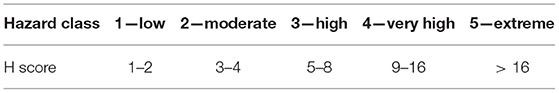
Table 1. Flood hazard classes for UNWH sites.
Exposure and Vulnerability Analysis of UNWH Sites
The second step of exposure analysis requires assigning a value to a site. Valuing cultural heritage for the purposes of a standard flood damage analysis is a challenging task. Although significantly related to many profitable economic activities, the value of cultural heritage is intangible and hardly monetizable since the significance of a cultural asset depends on the historical, spiritual, aesthetic, and social appreciation. Market values or reconstruction costs usually adopted in flood risk analyses are not easily obtained from willingness to pay or other economic methods (Sayce et al., 2009; Voltaire et al., 2017). The value of natural environments is also widely recognized but again intangible and hardly monetizable. Existing literature on flood risk of cultural heritage has not proposed yet a solution for valuing flood exposure, however Arrighi et al. (2022), proposed the use of the number of visitors as a proxy value to rank social appreciation of single cultural attractions at the city scale.
In this work, the intangible value of the site is determined based only on the number of UNESCO selection criteria assigned by the committee. No distinction is made on the relative importance among criteria. Each site satisfies one or more criteria for being included in the World Heritage list. It is assumed that the value of the site for humanity linearly increases with the number of criteria assigned to the site, so that the exposure E assumes the scores from 1 (one criterion) to 6 (six criteria) for cultural/mixed asset and from 1 (one criterion) to 4 (four criteria) for natural assets. Thus, the selection of the number of criteria assigned to the site as a proxy to rank exposure values reflects in a numerical weight the decision made by experts. Authenticity and integrity of properties are also essential characteristics which assign to UNWH sites outstanding intangible values. The use of number of criteria as a proxy for exposure allows for ranking cultural heritage sites in a social perspective by recognizing the significance of a site for the whole mankind. For example, a site satisfying two criteria, such as (i) an “important interchange of human values, […], on developments in architecture or technology, monumental arts, town-planning or landscape design” and bearing (ii) “a unique or at least exceptional testimony to a cultural tradition or to a civilization which is living, or which has disappeared” is assumed to have a higher intangible value than a site satisfying one criterion, e.g., “masterpiece of human creative genius.” This approach allows for valuing more historical cities than a single isolated structure, which usually fits a lower number of criteria.
The degree of harm suffered by cultural heritage is not easily modeled through vulnerability functions which assign to one or more flood parameters, usually water depth, a relative or absolute damage value. The direct contact with floodwaters might cause damages to (i) construction materials, e.g., wood, masonry structure, (ii) decorations and finishing materials e.g., frescoes or varnish, (iii) pieces of furniture and artworks. These damages are further aggravated by sediment/debris transport, dissolved contaminants, permanence time of water, however the link between these aspects and damages to cultural heritage is far to be understood. When large scale analyses are carried out the main way to rank the vulnerability of cultural heritage is to distinguish among site typologies which show similar constructive characteristics and presence of contents (Figueiredo et al., 2019; Garrote et al., 2020). In this work, the site typology has been classified into 7 categories to assign a vulnerability score for the risk analysis. The site typology has been obtained by manually analyzing the fields of name and item description. In fact, in some cases the name is enough to assign a typology, e.g., “NAME” = “Historic Centers of Berat and Gjirokastra” can be easily assigned to “V TYPE” = “City,” i.e., an historical city center. In other cases, such as “NAME” = “Ashur (Qal'at Sherqat)” the classification is not immediate and the description “SHORT_DESC” = “The ancient city of Ashur is located on the Tigris River in northern Mesopotamia […]” allows for assigning “V TYPE” = “City” Mixed sites which combine natural landscape and built structures are assimilated to cultural sites and associated to the typology of the prevalent built asset. No distinction in vulnerability is made between single asset and multiple assets except for cities/historical city centers which are considered as the most vulnerable typology. The identified categories are described below by increasing vulnerability score V. Although the vulnerability classification has a significant level of subjectivity, similar working hypotheses have been made for national/regional scale risk assessments (Figueiredo et al., 2019; Garrote et al., 2020).
Hydraulic infrastructure (single/multiple): they represent masterpieces of human capability to use water resources, designed to work in contact with water, thus they are considered less vulnerable to floods with respect to other built assets (V = 1). An example of this type of heritage is the Shushtar historical hydraulic system (Iran).
Archaeological site (single/multiple): they are the remains of ancient civilizations and may range from those with few or no remains visible above ground, to buildings and other structures still in use. They do not contain movable artworks, usually exhibited in museums. They are considered moderately vulnerable (V = 2). An example is the archaeological site of Moenjo-daro (Pakistan).
Industrial architecture (single/multiple): they are some of the pioneering structures of modern architecture and functional planning for industry. They are considered moderately vulnerable because usually constructed with resistant materials and on average do not exhibit precious contents (V = 3). The mills at Kinderdijk-Elshout (the Netherlands) are an example.
Defensive architecture (single/multiple): it includes towers and castles, the latter can have significant finishing levels and pieces of furniture or artworks witnessing ancient ways of living, thus this class is considered highly vulnerable (V = 4). An example of this class is the tower of London (UK).
Residential architecture (single/multiple): it includes buildings formerly used as residences often with a good finishing level and precious construction material and artworks thus this class is considered very highly vulnerable (V = 5). Residences of the Royal House of Savoy (Italy) are an example.
Religious architecture (single/multiple): it consists of all built manifestations of spiritual belief and religion, often with outstanding finishing levels, precious construction material and artworks and pieces of furniture, thus it is considered extremely highly vulnerable (V = 6). An example is the Cathedral of Seville (Spain).
City/historical city center (multiple): it includes in principle most of site categories, i.e., residential, defensive, religious structures etc., respective contents and artworks diffused into different historical layers, but also infrastructures and urban landscapes, thus it is considered at the maximum level of vulnerability (V = 7). The Historic Inner City of Paramaribo (Suriname) is an example.
Vulnerability combined with exposure is usually defined as potential damage D
Table 2 summarizes the identified site type, the vulnerability, and the exposure value. Five potential damage classes from low (1) to extreme (5) are identified.

Table 2. Potential flood damage classes for UNWH sites based on vulnerability V and exposure E scores (low 1–4, moderate 5–8, high 9–16, very high 17–32, extreme >32).
Risk Analysis of UNWH Sites
The risk classification combines the hazard H and potential damage D classes.
Five risk classes are obtained from low to extreme risk as shown in Table 3.
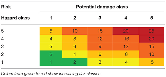
Table 3. Flood risk classes for UNWH sites based on hazard and potential damage scores (low 1–2, moderate 3–4, high 5–8, very high 8–16, extreme >16).
Results
All the elaborations carried out in this work can be read in the table provided as Supplementary Material, which includes the original attribute information of the UNESCO datasets and the new classification of hazard, exposure and vulnerability. This section describes the main results obtained.
The application of the flood hazard and exposure methodology to the UNWH sites dataset, shows that 23% of sites are exposed to river flooding globally. Namely, 35% of natural sites and 21% of cultural and mixed sites are exposed. Figure 2 shows the spatial distribution of exposed sites classified by typology.

Figure 2. Cultural, natural, and mixed UNWH sites exposed to river floods.
The 45% of cultural and mixed sites exposed to floods is affected by frequent events with 20-years or lower recurrence interval, these sites represent 7.5% of the overall number of UNWH. Europe and North America region counts 50% of UNWH sites exposed, followed by Asia and Pacific (27%) and Arab states (9%).
In terms of value of exposure, the most frequent number of eligibility criteria is two (43% of sites), six criteria have never been assigned so far to a site. With reference to Figure 3, it is possible to notice that about 30–40% of defensive, industrial, religious, and residential architectures are assigned three criteria. Four criteria are assigned to <20% of sites in each typology except for defensive architectures. Five criteria represent a very limited number of sites (5.6% of cities, 4% of residential architectures, 3.2% of archaeological sites, 2.9% of religious architectures). The distribution of number of criteria demonstrates that a few UNWH sites has an extraordinary significance for humanity (five criteria) that can be captured by the adopted exposure classification. The geographic area with the highest exposure values (4 or 5 criteria) is Europe and North America (12 sites) followed by Asia and the Pacific (8 sites).
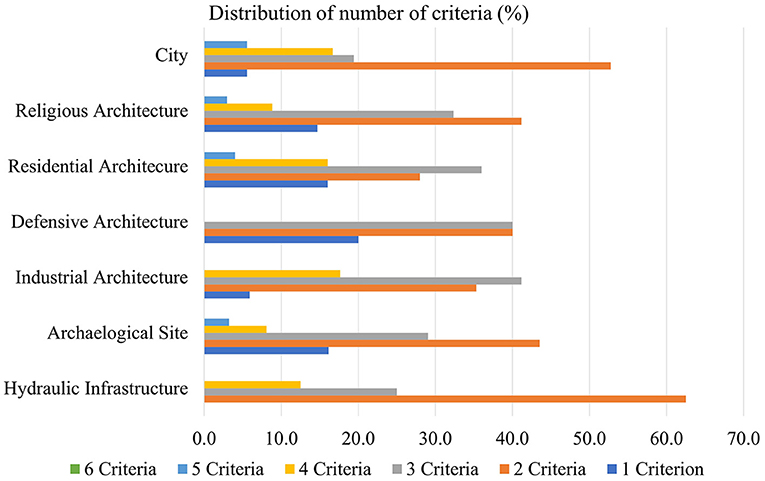
Figure 3. Distribution of number of criteria for UNWH cultural and mixed sites exposed to river floods.
For natural sites, the analysis yields that for the flood-exposed sites, 53% has been assigned two criteria, and 24% three criteria. It should be also noticed that 10.8% of overall sites is a water resource itself, thus it has been excluded from the current exposure analysis. Africa has the highest number of natural sites exposed to river floods (25 sites) followed by the Europe and North America Region (17 sites).
The results of the vulnerability analysis, carried out only for cultural and mixed sites, are shown in Figure 4. Circle and squares symbols depict multiple and single sites, respectively. Thirty-five exposed sites are cities (18.9% of exposure), thus with the highest vulnerability class. Archaeological sites, religious, residential, and industrial architectures make 33, 18, 13, and 9% of exposure, respectively. From the geographic point of view, higher vulnerability classes (V ≥ 5) are mostly located in the Europe and North America and in the Asia and Pacific regions with 63 and 18 sites, respectively.
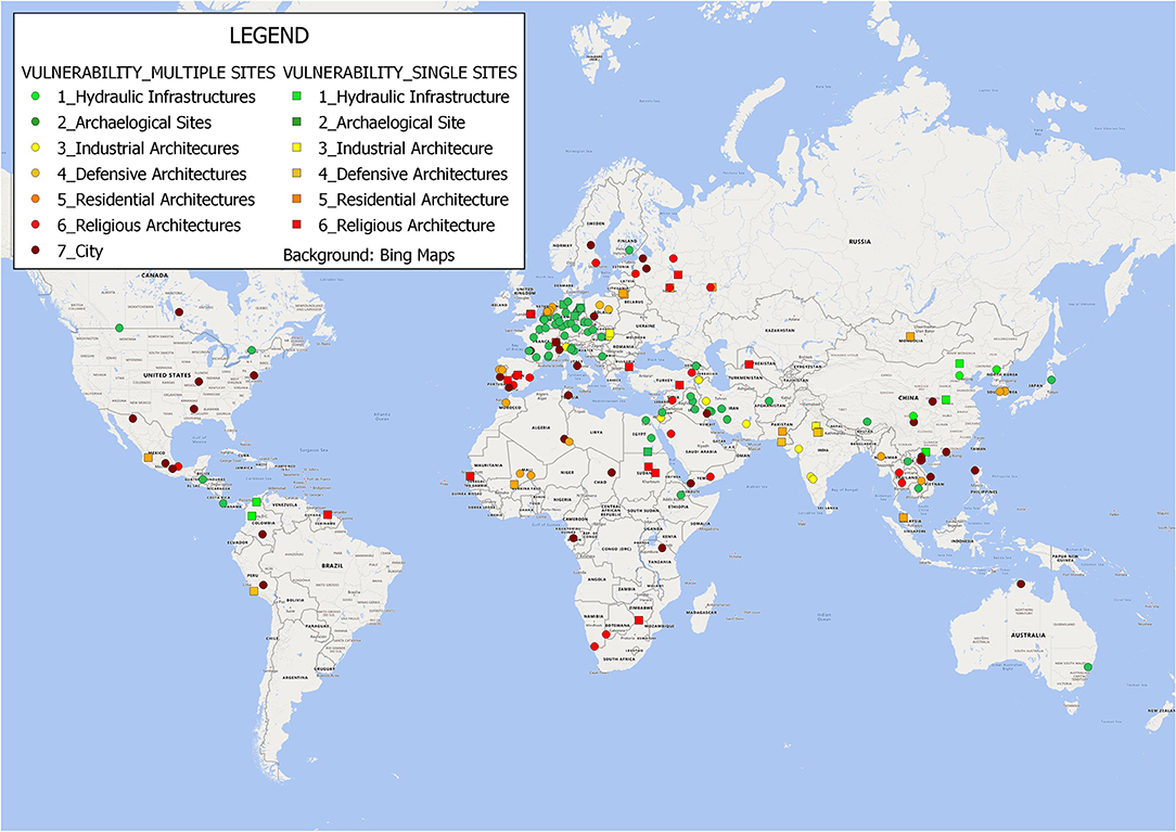
Figure 4. Vulnerability classification of cultural and mixed UNWH sites exposed to river floods.
The potential damage class obtained by combining exposure and vulnerability is shown in Figure 5. Two sites fall into the extreme potential damage class. Very high and high potential damage classes count 31 and 63 sites, respectively. This means that 96 UNWH sites (52% of exposure) can be severely damaged by flooding. Forty-two sites have a moderate potential damage and 47 a low potential damage.
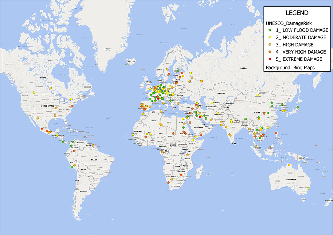
Figure 5. Potential damage classification of cultural and mixed UNWH sites exposed to river floods.
The combination of hazard and potential damage classes yields the risk classification which comprises five degrees of severity from low to extreme risk (Table 3) as shown in Figure 6. The figure represents all UNWH sites, with the white symbol describing the sites not exposed to riverine flooding.

Figure 6. River flood risk classification of cultural and mixed UNWH sites.
The 10% of exposed sites is classified at extreme risk which correspond to 2% of the total number of UNWH sites. 14 out of the 18 sites classified at extreme risk are in the Europe and North America region, 8 are historical cities. The remaining 4 sites are in the Asia and Pacific region. Table 4 summarizes the risk results.
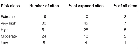
Table 4. Flood risk classification of UNWH sites and percentage with respect to exposed assets and total number of assets.
The risk results show significant high values, in fact 83% of exposed sites fall into a high, very high, or extreme risk classes. This is on one hand due to the fact that 45% of exposed sites have an extreme flood hazard level according to global maps, and on the other hand, that 52% of exposed sites potentially suffer of at least a high damage.
Vulnerability and exposure classifications, which are based on expert judgement, are sensitive parameters. In fact, if each site is shifted up one level of exposure, i.e., one more eligibility criterion is added, the number of extreme risk sites doubles and the number of very high and high risk sites remains the same. If each site is shifted up one level of vulnerability, the number of very high-risk sites increases of 25% and the number of extreme and high-risk sites remains almost constant. If the three upper risk classes are cumulated, the sensitivity to the exposure and vulnerability classification is quite negligible. In fact, the number of at least high-risk sites increases by 9 and 10% for a positive shift of exposure and vulnerability classes, respectively.
Discussion
The results of the river flood risk analysis identify two geographical regions where the number of UNWH sites is significant. In the Europe and North America region there are 14 UNWH sites at extreme risk and 47 at very high risk. This is driven by high exposure values (4 or 5 criteria frequently assigned) and high vulnerability (27 historical cities, 22 religious and 18 residential architectures). Moreover, the area hosts almost half of the UNWH sites (528 out of 1,121).
The second most at risk area is the Asia and Pacific region which hosts 266 sites, 4 of them at extreme risk and 19 at very high risk. Of the 66 sites exposed in this region about one third has a high vulnerability level (5 cities, 9 religious architectures, 4 residential architectures) and 10 have high exposure values (E ≥ 4). On the side of natural UNWH sites, the Africa and the Europe and North America regions have the highest number of natural sites exposed to river floods (25 and 17 sites, respectively).
Different aspects of the methodology and datasets used in this work require discussion, in order to identify limitations and future research directions. Risk analysis carried out at global scales suffers of several uncertainties which are intrinsic of the spatial resolution and availability of information, however a first-level analysis provides a general geographic overview and ranking which may raise awareness and promote more detailed local investigation at single site level. The dataset provided as Supplementary Material allows for browsing and identifying the hazard, exposure, vulnerability, and risk levels for any site of interest and can be re-used for other purposes, such as the analysis of other natural hazards. The main sources of uncertainties and limitations of the work are discussed below.
First, global river flood hazard maps are not able to describe local morphological aspects (Trigg et al., 2016) which might determine if a UNHW site is exposed or not. For example, let's assume that a religious architecture is located in a floodplain, but it is constructed upon an embankment or rock. It will result highly exposed to flood hazard but could be above the flood level. On the other hand, for example, archaeological sites which were excavated can be at a lower elevation than the surrounding floodplain areas, with consequent local higher water depths (Musumeci et al., 2021). Such errors in the hazard and exposure assessment can only be resolved by detailed flood models which can be usually adopted for site-scale analysis. Moreover, global river flood hazard maps do not include small order streams, thus the sites located in small catchments or in upper parts of large catchment do not result exposed. This is the case of Villa Romana del Casale (Italy) examined by Musumeci et al. (2021) which lies in a catchment of few square kilometers, or the monastery of Sucevita (Romania) (Hapciuc et al., 2016) located in the upper catchment of Sucevita stream, which resulted not exposed in our analysis. For other cases the risk classification was consistent with previous studies and historical reports. Some examples are reported here. The historic city of Ayutthaya (Thailand) is classified at high river flood risk, consistently with the local studies (Daungthima and Hokao, 2013; Vojinovic et al., 2021). The historic center of Prague (Czech Republic) in this work is classified at extreme flood risk and was severely affected by the 2002 flood and moderately by the 2013 flood of the Vltava river. The minaret and archaeological remains of Jam (Afghanistan), classified at extreme risk, were affected by a recent flood of the Harirud river in 2019. UNESCO is now working to reduce risks caused by flooding. Given the limitations of hazard data for small catchments, the exposed sites identified in this work are probably underestimated, therefore specific analysis should be carried out on UNWH sites located in small catchments.
Second, the majority of UNWHS are multiple sites, which means not only portion of cities or historical centers but also ensembles of architectures or natural environments showing the same characteristics. Multiple sites are shared by UNESCO website as a single georeferenced point. When these multiple sites are in the same geographic area, the use of a buffer, as in this work, might capture flood hazard and exposure. Nevertheless, when considering large geographic areas or transboundary sites, the results of the risk analysis are not reliable since the analysis yields the result for one of them, which might not be exposed. Transboundary sites are 39 globally, 23 of them are cultural/mixed (3 are exposed to floods) and 16 are natural. It is thus strongly advised to make a complete georeferenced dataset open available in future, to be used for research and informative purposes. The current information associated to the point coordinates of the sites does not allow for an automated classification of the nature of the site, i.e., single or multiple, except in the textual description, nor it is possible to understand the geographic extent of the area. Moreover, also a polygonal shapefile would be useful, especially but not limited to natural sites, which have a significant spatial extent and might intersect flood hazard zones.
Third, vulnerability classification for cultural/mixed sites is qualitative and groups UNWH sites into seven typologies which might have different damage mechanisms and susceptibility inside the same class. Vulnerability of buildings, often assumed as static, might also change over time due to aging and this is particularly significant for cultural heritage. Specific physical actions on different construction materials and the role of other flood characteristics such as flow velocity, sediment transport, or flood duration are pieces of information currently not available at this scale and could be investigated at the local scale. Moreover, the current state of the art does not provide adequate methodologies for assessing flood potential damages to natural environments, thus this work only evaluated flood exposure. In fact, although river flooding is a natural phenomenon which maintains the vitality of some ecosystems, floodwaters can transport contaminants related to industrial, agricultural, and urban activities (Arrighi et al., 2018b) whose impacts are not easily understood and simulated.
Fourth, exposure analysis does not consider the role of the UNWH site into the socio-economic context, i.e., the indirect monetary value of sites used to foster profitable activities (e.g., tourism). Also, coping capacity of the communities close to the site plays a crucial role in post event recovery and could not be investigated at global scale. However, this aspect can be of paramount importance for assessing the resilience of UNWH sites and nearby communities. In fact, despite the highest number of very high and extreme risk sites are located in Europe and North America, this region has probably well-established and effective preparedness and contingency plans which contributes to risk mitigation. Thus, it would be recommendable to account for coping capacity in future research especially in the context of future climate scenarios which identified Southern Asia as more frequently affected by river flooding (Merz et al., 2021).
More detailed catchment or site-scale risk analysis could resolve most of the limitations here described and is fundamental to raise awareness and protect unique cultural heritage of outstanding universal value.
Conclusions
This work has described a global riverine flood risk analysis of cultural and mixed UNWH sites based on hazard, exposure, and vulnerability classifications. Natural sites have been analyzed only in terms of hazard and exposure due to the lack of methods to establish vulnerability to floods. Such a global first-level river flood risk analysis has never been attempted before. Hazard maps made available by JRC (Dottori et al., 2016) have been used to identify natural and cultural/mixed sites exposed to floods, based on the geographic location provided by UNESCO. Exposure value has been classified by means of the number of criteria which motivated the inscription of the site in the World Heritage list, in order to rank the sites based on their significance for mankind. In similar flood risk studies at national or regional scales exposure values were not evaluated (Figueiredo et al., 2019; Garrote et al., 2020). Seven vulnerability classes have been created and assigned to the cultural/mixed sites based on their typology. The analysis shows that 23% of sites are exposed to river flooding globally. Thirty-five percentage of them are natural sites (sites coinciding with water resources are excluded) and 21% are cultural and mixed sites. For cultural and mixed sites, the combined analysis of vulnerability and exposure reveals that 52% of exposed sites potentially suffer of at least high damage. Overall, 9% of the global UNWH is classified at very high or extreme risk of river flood. These sites are mostly located in the Europe and North America Region (62 sites) and in the Asia and Pacific Region (23 sites), which host a significant number of historical cities, and religious and residential architectures classified at high vulnerability. North-western Europe and South-East Asia have been also identified as increasingly flood prone in the near future (Merz et al., 2021), thus they should receive a specific attention. This work has also highlighted the significant uncertainties related to the scale of analysis, the geographic localization of sites and challenges in vulnerability quantification for both natural and built assets, which could be addressed by researchers in future. The provided Supplementary Material allows the reader to browse for the most at risk asset in each geographic region and its hazard, exposure, and vulnerability levels based on the described methodology. Moreover, despite the growing international attention to disaster risk reduction and the significant developments of legislative frameworks, such as the European Directive 60/2007/EC, complete georeferenced cultural heritage datasets are only sparsely available also at regional levels. The availability of cultural heritage georeferenced data, systematically collected, stored, and updated is therefore crucial not just for the outstanding social, aesthetic, or religious values potentially threatened by natural hazards but also for the resilience of communities and livelihoods and should be carefully considered in national and regional risk management plans.
Data Availability Statement
The original contributions presented in the study are included in the article/Supplementary Material, further inquiries can be directed to the corresponding author/s.
Author Contributions
The author confirms being the sole contributor of this work and has approved it for publication.
Funding
CA was supported by the Università degli Studi di Firenze, Firenze (Italy).
Conflict of Interest
The author declares that the research was conducted in the absence of any commercial or financial relationships that could be construed as a potential conflict of interest.
Publisher's Note
All claims expressed in this article are solely those of the authors and do not necessarily represent those of their affiliated organizations, or those of the publisher, the editors and the reviewers. Any product that may be evaluated in this article, or claim that may be made by its manufacturer, is not guaranteed or endorsed by the publisher.
Acknowledgments
Martina Sorelli is kindly acknowledged for her contribution to the preparation of the Supplementary Material and maps.
Supplementary Material
The Supplementary Material for this article can be found online at: https://www.frontiersin.org/articles/10.3389/frwa.2021.764459/full#supplementary-material
References
Amadio, M., Rita Scorzini, A., Carisi, F., Essenfelder, H. A., Domeneghetti, A., Mysiak, J., et al. (2019). Testing empirical and synthetic flood damage models: the case of Italy. Nat. Hazards Earth Syst. Sci. 19, 661–678. doi: 10.5194/nhess-19-661-2019
Ankersmit, B., and Stappers, M. H. L. (2017). Managing Indoor Climate Risks in Museums, 1st Edn. New York, NY: Springer. doi: 10.1007/978-3-319-34241-2
Appiotti, F., Assumma, V., Bottero, M., Campostrini, P., Datola, G., Lombardi, P., et al. (2020). Definition of a risk assessment model within a European Interoperable Database platform (EID) for cultural heritage. J. Cult. Herit. 46, 268–277. doi: 10.1016/j.culher.2020.08.001
Arrighi, C., Brugioni, M., Castelli, F., Franceschini, S., and Mazzanti, B. (2018a). Flood risk assessment in art cities: the exemplary case of Florence (Italy). J. Flood Risk Manage. 11, S616–S631. doi: 10.1111/jfr3.12226
Arrighi, C., Carrarresi, A., and Castelli, C. (2022). Resilience of art cities to flood risk: a quantitative model based on depth-idleness correlation, accepted for publication. J. Flood Risk Manag. 38, 120–8.
Arrighi, C., Masi, M., and Iannelli, R. (2018b). Flood risk assessment of environmental pollution hotspots. Environ. Model. Software 100, 1–10. doi: 10.1016/j.envsoft.2017.11.014
Bajçinovci, B., and Thaçi, K. (2016). Heritage and artistic boon: valuing prizren castle. J. Sci. Humanit. Arts 3. doi: 10.17160/josha.3.5.228
Barendrecht, M. H., Viglione, A., and Blöschl, G. (2017). A dynamic framework for flood risk. Water Security 1, 3–11. doi: 10.1016/j.wasec.2017.02.001
Brémond, P., and Grelot, F. (2013). Review article: economic evaluation of flood damage to agriculture - review and analysis of existing methods. Nat. Hazards Earth Syst. Sci. 13, 2493–2512. doi: 10.5194/nhess-13-2493-2013
Cammerer, H., Thieken, A. H., and Lammel, J. (2013). Adaptability and transferability of flood loss functions in residential areas. Nat. Hazards Earth Syst. Sci. 13, 3063–3081. doi: 10.5194/nhess-13-3063-2013
Carisi, F., Schröter, K., Domeneghetti, A., Kreibich, H., and Castellarin, A. (2018). Development and assessment of uni- and multivariable flood loss models for Emilia-Romagna (Italy). Nat. Hazards Earth Syst. Sci. 18, 2057–2079. doi: 10.5194/nhess-18-2057-2018
CRED (2015). The Human Cost of Natural Disaters 2015: A Global Perspective. Retreived from: https://reliefweb.int/sites/reliefweb.int/files/resources/PAND_report. (accessed December 13, 2021).
Daungthima, W., and Hokao, K. (2013). Analysing the possible disasters on cultural heritage. Int. J. Sustain. Future Human Security 1, 35–39. doi: 10.24910/jsustain/1.1/3539
Del Saz Salazar, S., and Montagud Marques, J. (2005). Valuing cultural heritage: the social benefits of restoring and old Arab tower. J. Cult. Herit. 6, 69–77. doi: 10.1016/j.culher.2004.09.001
Di Mauro, M., De Bruijn, K. M., and Meloni, M. (2012). Quantitative methods for estimating flood fatalities: towards the introduction of loss-of-life estimation in the assessment of flood risk. Nat. Hazards 63, 1083–1113. doi: 10.1007/s11069-012-0207-4
Dottori, F., Salamon, P., Bianchi, A., Alfieri, L., Hirpa, F. A., and Feyen, L. (2016). Development and evaluation of a framework for global flood hazard mapping. Adv. Water Resour. 94, 87–102. doi: 10.1016/j.advwatres.2016.05.002
Fatorić, S., and Seekamp, E. (2017). Are cultural heritage and resources threatened by climate change? A systematic literature review. Clim. Change 142, 227–254. doi: 10.1007/s10584-017-1929-9
Figueiredo, R., Romão, X., and Paupério, E. (2019). Flood risk assessment of cultural heritage at large spatial scales: framework and application to mainland Portugal. J. Cult. Herit. 43, 163–174. doi: 10.1016/j.culher.2019.11.007
Figueiredo, R., Romão, X., and Paupério, E. (2021). Component-based flood vulnerability modelling for cultural heritage buildings. Int. J. Disast. Risk Reduct. 61:102323. doi: 10.1016/j.ijdrr.2021.102323
Garrote, J., Díez-Herrero, A., Escudero, C., and García, I. (2020). A framework proposal for regional-scale flood-risk assessment of cultural heritage sites and application to the Castile and León Region (Central Spain). Water 12:329. doi: 10.3390/w12020329
Gerl, T., Kreibich, H., Franco, G., Marechal, D., and Schröter, K. (2016). A review of flood loss models as basis for harmonization and benchmarking. PLoS ONE 11:e0159791. doi: 10.1371/journal.pone.0159791
Habermann, N., and Hedel, R. (2018). Damage functions for transport infrastructure. Int. J. Disast. Resilience Built Environ. 9, 420–434. doi: 10.1108/IJDRBE-09-2017-0052
Hapciuc, O. E., Romanescu, G., Minea, I., Iosub, M., Enea, A., and Sandu, I. (2016). Flood susceptibility analysis of the cultural heritage in the Sucevita catchment (Romania). Int. J. Conserv. Sci. 7, 501–510.
Huizinga, J., de Moel, H., and Szewczyk, W. (2017). Global flood depth-damage functions: Methodology and the database with guidelines, EUR 28552 EN. Luxembourg: Publications Office of the European Union. doi: 10.2760/16510
Jonkman, S. N. (2007). Loss of Life Estimation in Flood Risk Assessment - Theory and Applications. (Doctoral thesis). Available online at: https://library.wur.nl/ebooks/hydrotheek/1875249.pdf (accessed December 13, 2021).
Marzeion, B., and Levermann, A. (2014). Loss of cultural world heritage and currently inhabited places to sea-level rise. Environ. Res. Lett. 9:034001. doi: 10.1088/1748-9326/9/3/034001
Merz, B., Blöschl, G., Vorogushyn, S., Dottori, F., Aerts, J. C. J. H., Bates, P., et al. (2021). Causes, impacts and patterns of disastrous river floods. Nat. Rev. Earth Environ. 2, 592–609. doi: 10.1038/s43017-021-00195-3
Michielsen, A., Kalantari, Z., Lyon, S. W., and Liljegren, E. (2016). Predicting and communicating flood risk of transport infrastructure based on watershed characteristics. J. Environ. Manage. 182, 505–518. doi: 10.1016/j.jenvman.2016.07.051
Miranda, F. N., and Ferreira, T. M. (2019). A simplified approach for flood vulnerability assessment of historic sites. Nat. Hazards 96, 713–730. doi: 10.1007/s11069-018-03565-1
Molinari, D., Scorzini, A. R., Arrighi, C., Carisi, F., Castelli, F., Domeneghetti, A., et al. (2020). Are flood damage models converging to reality? Lessons learnt from a blind test. NHESS 20, 2997–3017. doi: 10.5194/nhess-20-2997-2020
Molinari, D.aniela, Rita Scorzini, A., Gallazzi, A., and Ballio, F. (2019). AGRIDE-c, a conceptual model for the estimation of flood damage to crops: development and implementation. Nat. Hazards Earth Syst. Sci. 19, 2565–2582. doi: 10.5194/nhess-19-2565-2019
Musumeci, R. E., Foti, E., Li Rosi, D., Sanfilippo, M., Stancanelli, L. M., Iuppa, C., et al. (2021). Debris-flow hazard assessment at the archaeological UNESCO world heritage site of villa romana del casale (sicily, Italy). Int. J. Disast. Risk Reduct. 64:102509. doi: 10.1016/j.ijdrr.2021.102509
Navrud, S., and Ready, R. C. (2002). Valuing Cultural Heritage: Applying Environmental Valuation Techniques to Historic Buildings, Monuments and Artifacts. (Cheltenham: Edward Elgar). doi: 10.4337/9781843765455
Orr, S. A., Richards, J., and Fatori,ć, S. (2021). Climate change and cultural heritage: a systematic literature review (2016–2020). Historic Environ. Policy Pract. 12, 434–477. doi: 10.1080/17567505.2021.1957264
Pregnolato, M., Ford, A., Wilkinson, S. M., and Dawson, R. J. (2017). The impact of flooding on road transport : a depth-disruption function. Transport. Res. D 55, 67–81. doi: 10.1016/j.trd.2017.06.020
Reimann, L., Vafeidis, A., Brown, S., Hinkel, J., and Tol, R. S. J. (2018). Mediterranean UNESCO World Heritage at risk rise. Nat. Commun. 9:4161. doi: 10.1038/s41467-018-06645-9
Rolfe, J., and Windle, J. (2003). Valuing the protection of aboriginal cultural heritage sites. Econ. Rec. 79, S85–S95. doi: 10.1111/1475-4932.00094
Sayce, S., Britton, P., Morris, A., Anna, S., and Watkins, D. (2009). “Valuing heritage assets,” in RICS ed H. M. Treasury (London: Kingston University). Available online at: https://eprints.kingston.ac.uk/id/eprint/15845/1/Sayce-S-15845.pdf (accessed December 13, 2021).
Sesana, E., Gagnon, A. S., Ciantelli, C., Cassar, J. A., and Hughes, J. J. (2021). Climate change impacts on cultural heritage: a literature review. Wiley Interdiscip. Rev. Clim. Change 12, 1–29. doi: 10.1002/wcc.710
Stanton-Geddes, Z., and Soz, S. A. (2017). Promoting Disaster Resilient Cultural Heritage. (Washington, DC: World Bank). Available online at: https://openknowledge.worldbank.org/handle/10986/28955 (accessed September 19, 2021).
Thieken, A. H., Olschewski, A., Kreibich, H., Kobsch, S., and Merz, B. (2008). Development and evaluation of FLEMOps - a new flood loss estimation MOdel for the private sector. WIT Transact. Ecol. Environ. 118, 315–324. doi: 10.2495/FRIAR080301
Trigg, M. A., Birch, C. E., Neal, J. C., Bates, P. D., Smith, A., Sampson, C. C., et al. (2016). The credibility challenge for global fluvial flood risk analysis. Environ. Res. Lett. 11:094014. doi: 10.1088/1748-9326/11/9/094014
Trizio, F., Torrijo, F. J., and Mileto, C. (2021). Flood risk in a Heritage City : Alzira as a case study. Water 13:1138. doi: 10.3390/w13091138
UNESCO (1972). Convention Concerning the Protection of the World Cultural and Natural Heritage. Available online at: https://whc.unesco.org/en/conventiontext/ (accessed December 13, 2021).
Vojinovic, Z., Alves, A., Gómez, J. P., Weesakul, S., Keerakamolchai, W., Meesuk, V., et al. (2021). Effectiveness of small- and large-scale Nature-Based Solutions for flood mitigation: the case of Ayutthaya, Thailand. Sci. Total Environ. 789:147725. doi: 10.1016/j.scitotenv.2021.147725
Vojinovic, Z., Hammond, M., Golub, D., Hirunsalee, S., Weesakul, S., Meesuk, V., et al. (2016). Holistic approach to flood risk assessment in areas with cultural heritage : a practical application. Nat. Hazards 81, 589–616. doi: 10.1007/s11069-015-2098-7
Voltaire, L., Lévi, L., Alban, F., and Boncoeur, J. (2017). Valuing cultural world heritage sites: an application of the travel cost method to Mont-Saint-Michel. Appl. Econ. 49, 1593–1605. doi: 10.1080/00036846.2016.1221046
Keywords: cultural heritage, flood risk analysis, exposure, vulnerability, open data, river flood, UNESCO World Cultural Heritage
Citation: Arrighi C (2021) A Global Scale Analysis of River Flood Risk of UNESCO World Heritage Sites. Front. Water 3:764459. doi: 10.3389/frwa.2021.764459
Received: 25 August 2021; Accepted: 01 December 2021;
Published: 23 December 2021.
Edited by:
Maria Pregnolato, University of Bristol, United KingdomReviewed by:
Alfred Owuor Opere, University of Nairobi, KenyaMario Martina, University School for Advanced Studies IUSS Pavia, Italy
Copyright © 2021 Arrighi. This is an open-access article distributed under the terms of the Creative Commons Attribution License (CC BY). The use, distribution or reproduction in other forums is permitted, provided the original author(s) and the copyright owner(s) are credited and that the original publication in this journal is cited, in accordance with accepted academic practice. No use, distribution or reproduction is permitted which does not comply with these terms.
*Correspondence: Chiara Arrighi, chiara.arrighi@unifi.it