
City Information Modeling: State of the Art


1
Beijing Key Laboratory of Urban Underground Space Engineering, School of Civil and Resource Engineering, University of Science and Technology Beijing, Beijing 100083, China
2
Key Laboratory of Earthquake Engineering and Engineering Vibration, Institute of Engineering Mechanics, China Earthquake Administration, Sanhe 065201, China
*
Author to whom correspondence should be addressed.
Appl. Sci. 2021, 11(19), 9333; https://0-doi-org.brum.beds.ac.uk/10.3390/app11199333
Submission received: 10 August 2021
/
Revised: 28 September 2021
/
Accepted: 29 September 2021
/
Published: 8 October 2021
(This article belongs to the Topic Advances on Structural Engineering)
Abstract
:The concept of city information modeling (CIM) has become increasingly popular in recent years. A literature review of previous CIM studies is presented in this paper. First, a bibliometric analysis of the current global CIM research is described, revealing that CIM has become a significant research hotspot. Next, three main research areas of the current CIM technique, namely data collection, integration, and visualization, are summarized to describe the characteristics of CIM research. Furthermore, some widely used CIM platforms are compared, and typical application cases of the CIM technique at different stages of the city life cycle are summarized. Finally, the current issues in CIM research are discussed, and future development directions are proposed. The findings of this study are expected to help researchers understand the current state of CIM and identify future development directions, thereby promoting CIM research development.
1. Introduction
The concept of city information modeling (CIM) was presented by Khemlani [1,2,3,4] in 2007. With the development of building information modeling (BIM) technology, Khemlani extended and applied information modeling from the building level to the city level. Therefore, CIM was initially accepted as a form of BIM technology specifically applied to cities.
According to Xu et al. [5], CIM can be established by integrating BIM and the geographic information system (GIS). Xu et al. developed a CIM framework compatible with a standard data format, namely the industry foundation class (IFC) [6] and city geography markup language (CityGML, a typical format for GIS data) [7]. BIM can provide internal component-level building information, whereas GIS can provide external information about buildings. Therefore, the trans-scale CIM covering internal and external buildings can be developed by incorporating microBIM and macroGIS data [8], indicating that CIM has promising research applications.
Wu et al. [9] extended the CIM concept to an intelligent city model. For this concept, the Internet of Things (IoT), BIM, and GIS are the primary technical support of CIM for collecting, storing, and processing large data. Advanced technology, such as cloud computing [10], big data [11], virtual reality (VR) [12], and artificial intelligence (AI) [13], has gradually been used for CIM to build smart cities. For example, cloud computing improves the data processing capability of CIM, while VR provides a new method of city visualization.
The above concepts reveal that CIM is a three-dimensional (3D) city model based on city information data with a multidisciplinary collaborative framework. CIM has been the foundational model for smart and digital-twin cities, owing to its comprehensive information integration. Currently, many countries are conducting CIM-related research [14,15], such as the Digital Built Britain project [16,17]. However, research in this area is emerging, and a comprehensive review of the nature of the CIM technique is required.
A literature review of previous CIM studies is presented in this paper. First, a bibliometric analysis of the current global CIM research is discussed, revealing that CIM has become a significant research hotspot. Next, three main research areas of the current CIM technology, namely data collection, integration, and visualization, are summarized to show the characteristics of CIM research. Furthermore, some well-known CIM platforms are compared, and the typical application cases of the CIM technique at different stages of the city life cycle are summarized. Finally, the existing issues in CIM research are discussed, and future development directions are proposed.
2. Bibliometric Analysis
2.1. Analysis Method
“City information model” and “city information modeling” were used as search keywords, and 1648 papers were retrieved from the core database of the Web of Science (from 1985 to 2020). These papers are related to the following six fields: construction building technology, civil engineering, regional and urban planning, urban studies, computer science interdisciplinary applications, and computer science information systems. These papers were analyzed using an online analysis platform published by bibliometric.com [18].
2.2. Analysis Results
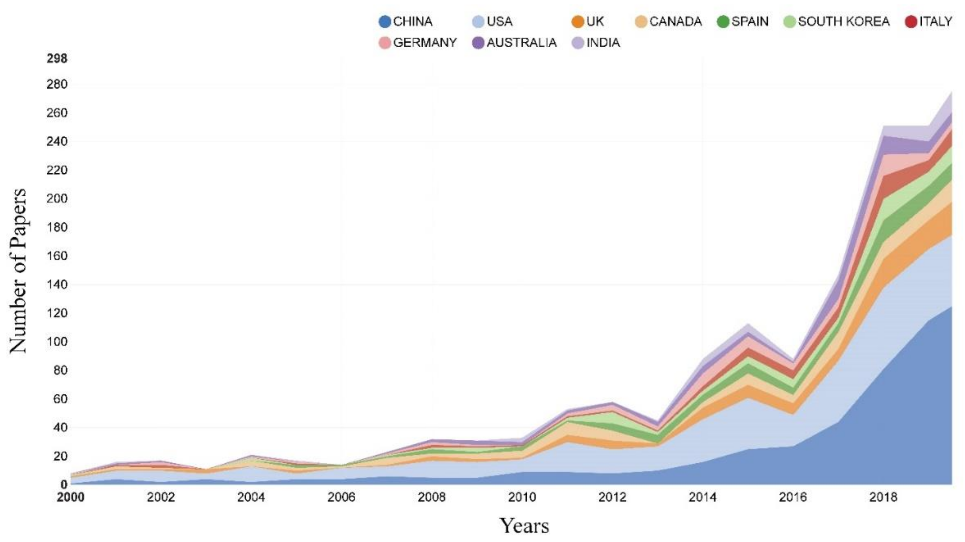
Figure 1 shows the increasing trend in the number of CIM-related papers within the core database of the Web of Science from 2000 to 2020. The rate of increase, particularly after 2016, demonstrates significant acceleration and signifies that CIM research is currently experiencing proliferation.
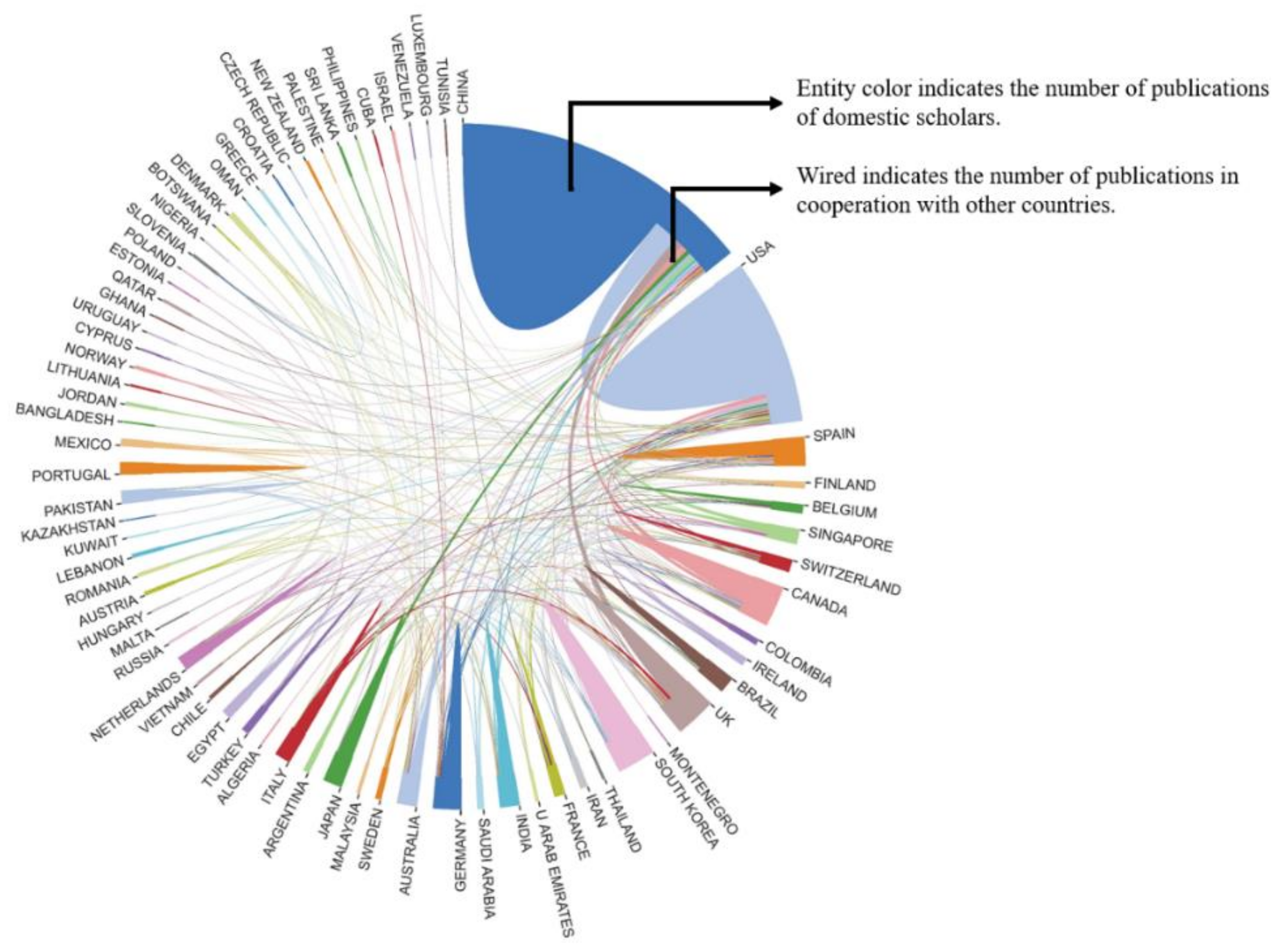
The number of publications from different countries where CIM studies are conducted is shown in Figure 2. CIM-related studies have been conducted in many countries. China, the United States, the United Kingdom, Canada, and Spain have conducted more studies in CIM than other countries, among which China and the United States have demonstrated active international cooperation, generating the most significant research impact on CIM.
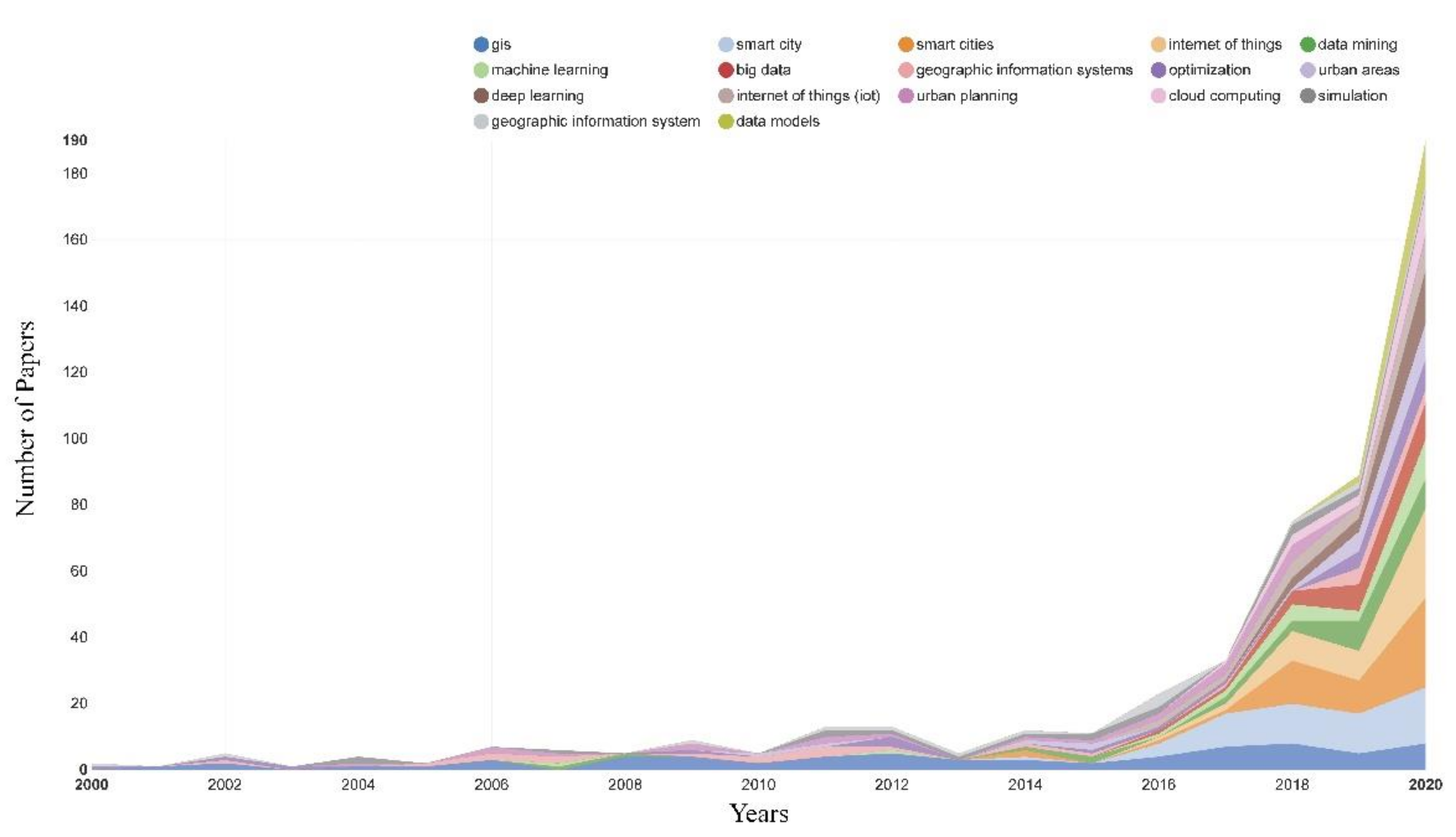
Figure 3 depicts the keywords of the above papers related to CIM. The keywords are divided into two categories. The first category is used to describe the technical research aspects of CIM, such as GIS, BIM, IoT, data mining, and machine learning, whereas the second category mainly identifies the CIM application areas, such as smart cities, urban planning, and simulations. The keywords in the technical research aspects indicated that previous studies on CIM techniques focused significant attention on integration with many emerging techniques (such as BIM, IoT, and machine learning). For the application areas, the keywords shows that smart cities are a popular area of CIM.
3. CIM Research Areas
Based on the processing step of city data, CIM research areas can be divided into three parts: data collection, integration, and visualization. Research on these three categories is summarized to describe the characteristics of CIM research.
3.1. Data Collection
CIM is based on the 3D model of a city, containing the static attribute data (e.g., building structure type and height) and dynamic data (e.g., real-time traffic flow). Therefore, research studies on CIM data collection can be divided into collections of the 3D model, static attribute data, and dynamic data of the city.
- 1.
- Collection of 3D City Model
The 3D city model is the foundational model of CIM that provides a refined geometrical expression of the 3D city space. Currently, satellite remote sensing, oblique photography, and light laser detection and ranging (LiDAR) are the major techniques applied to obtain raw data to reconstruct 3D models at the city level. These methods have different modeling principles and characteristics, including advantages and disadvantages in obtaining data, modeling scale, and modeling precision, as listed in Table 1.
Table 1 shows that satellite remote sensing can be used for the large-scale, low-precision modeling of cities, whereas oblique photography is suitable for producing highly realistic and moderate-precision models. LiDAR can develop high-precision models with high costs and heavy workloads. Thus, it is generally utilized for modeling small areas in a city. Based on the modeling requirements (e.g., precision and area) of CIM, suitable 3D modeling methods for CIM can be determined from Table 1.
- 2.
- Collection of Static Attribute Data of City
The manual collection of the static attribute data of a city is time-consuming and laborious. Therefore, the following new techniques should be fully adopted to collect the static attribute data of a city for CIM.
In terms of data sources, a variety of urban static data can be used to mine other related data, which is significantly valuable. For example, Molnár et al. [21] established a modified static database to mine urban heat island data using satellite images and building information.
In terms of algorithms, various machine learning algorithms can deduce vital information that is difficult to obtain directly [22]. For example, Henn et al. [23] presented a classifier based on support vector machines (SVMs) for semantic enrichment of coarse 3D city models by deriving the building type.
For computing, cloud computing can process large amounts of data within a short time, enhancing the data collection for CIM [24,25,26]. Xu et al. [27] established a machine learning model to predict the structural types of buildings based on cloud computing. This model can collect data on the structural type for building groups in a large city and further enrich the CIM model.
- 3.
- Collection of Dynamic Data of City
The dynamic data of the CIM can be obtained using IoT technology. Previous related research [28,29,30,31] can be divided into perception, communication, and application.
IoT-based perception collects the status-quo information for CIM, such as traffic, weather, and crowds. For instance, a real-time urban seismic network of Catania, Italy, was developed, in which a three-axis accelerometer was used to collect shaking data [28].
The communication efficiency of an IoT network is a critical issue for a CIM platform with multiple sensors. Mazhar et al. [29] developed an innovative architecture for a software-defined network for high-bandwidth communication. This architecture may be a potential solution for IoT communication on the CIM platform.
3.2. Data Integration
CIM data exist in large volumes and are obtained from various sources, making it challenging to integrate the data. Therefore, effective frameworks and methods for the data integration of CIM are necessary. This paper presents a summary of previous research on the above frameworks and methods.
- 1.
- Integrated Framework
Various definitions of CIM lead to different frameworks. Wang et al. [32] opine that CIM is an extension of BIM, in which urban infrastructure and geographic information are combined based on BIM architecture. Lee et al. [33] classified the CIM framework into three modules (that is, land, facilities, and water bodies) based on flood analysis. By comparison, the framework proposed by Xu et al. has a more comprehensive classification, including architecture, transportation, water bodies, mechanical, electrical, plumbing, and infrastructure [5].
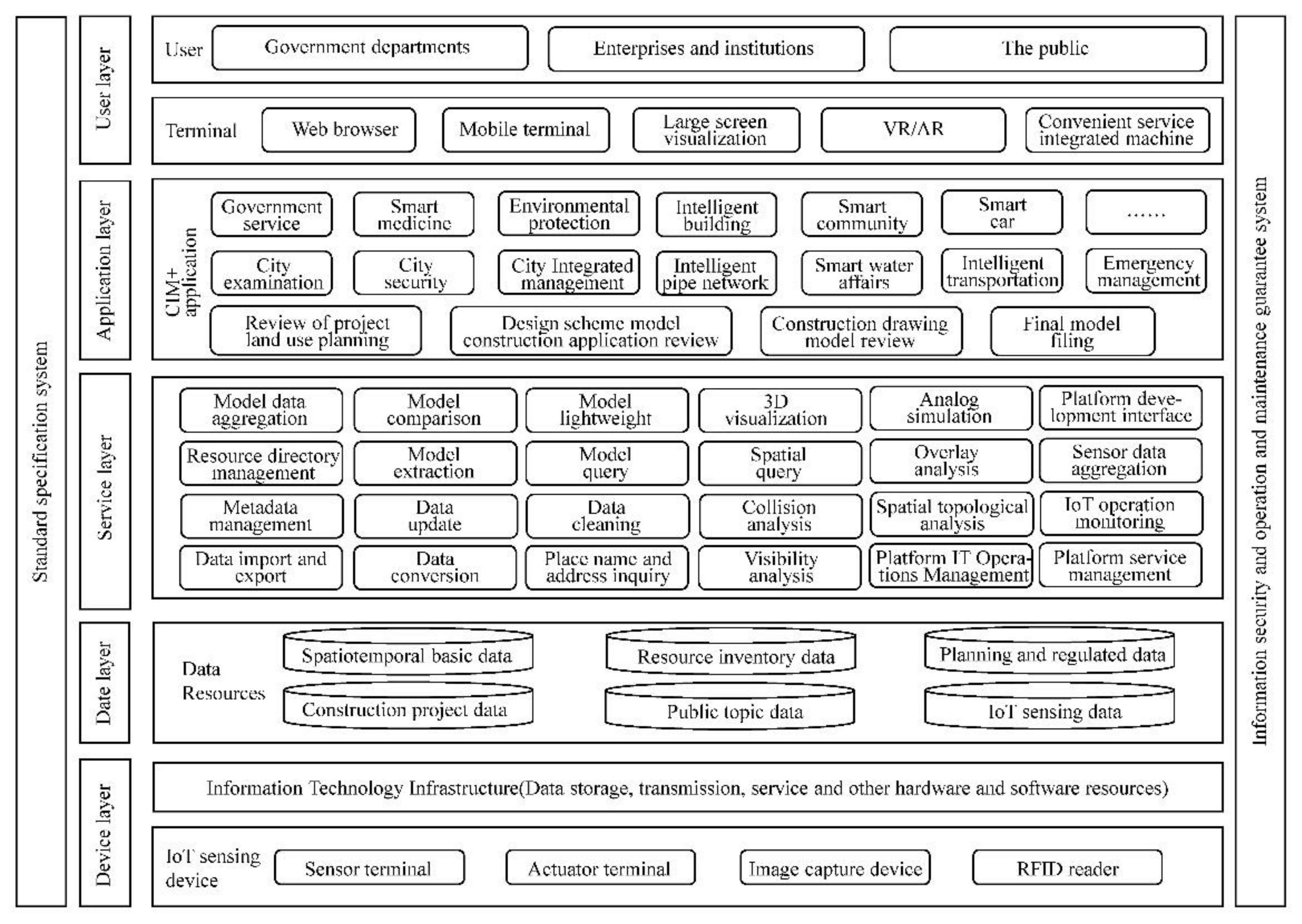
In September 2020, the Ministry of Housing and Urban-Rural Development (MHURD) of China published the Technical Guidelines on the Basic Platform of City Information Modeling [34]. The framework of the CIM basic platform recommended in the guideline is depicted in Figure 4, showing five layers (device, data, service, application, and user). This framework can integrate multisource data and serve different application scenarios. The above review indicates that most existing CIM frameworks are oriented toward specific applications. Therefore, the framework developed by the MHURD of China is recommended.
- 2.
- Data Integration Method
Data integration is considered a critical factor in CIM. City geographic information is typically stored using GIS technology, whereas most internal building information is managed using BIM and computer-aided design (CAD) technology. Thus, the data integration method can be divided into two categories: GIS–CAD and GIS–BIM.
CAD-based models exclude detailed information about buildings; therefore, the CIM generated using CAD and GIS has limitations, such as information retrieval and format conversion [35,36]. In contrast, BIM-based models have high-fidelity 3D geometries and include sufficient details about buildings, leading to better advantages for integration with GIS.
Currently, the integration of BIM and GIS has become a widely used modeling method for CIM [37,38]. IFC and CityGML are international data standards for BIM and GIS, respectively. Based on these two standards, the integration methods of BIM and GIS can be divided into four categories [5,39], that is, direct conversion, mapping, plug-in, and semantic web technology. The advantages and disadvantages of these methods are listed in Table 2. Generally, current BIM–GIS integration methods are imperfect, and further studies are required.
3.3. Data Visualization
The visualization of the CIM data can not only help people better understand the city but also assist in decision-making at all stages of the city life cycle [12,40,41,42,43]. Therefore, the CIM visualizations integrating VR and augmented reality (AR) have drawn the main research concerns (see Table 3).
Some CIM visualization platforms have been developed. Simstadt, a city simulation platform developed by Fachhochschule Stuttgart in 2013 [44,45], can visualize multi-level-of-detail CIM models based on CityGML. As an open-source CIM platform, NASA World Wind [46,47,48] allows developers to create interactive visualizations of 3D globe, map, and geographical information quickly and easily.
In terms of combination with VR, a VR company developed an application of VR based on CIM, by which the Yekaterinburg Center was visualized in a 3D walkthrough way [49]. Tschirschwitz et al. [50] established a CIM model which showed Duisburg city in 1566 by using VR.
In terms of combination with AR, Urban CoBuilder allows users to explore the city environment and participate in urban planning by integrating CIM with AR games [51], through which some data required in urban planning can be collected. An AR app called ARUJI (Augmented Reality University Jaume I) [40] can provide the points of interest (POIs) around Jaume I University when users select them on the screen of their smart devices. With the help of AR, ARUJI realized urban navigation in a visual way, which is a good application based on CIM.
4. CIM Applications
4.1. Typical Applications
CIM can be applied in the entire life cycle of cities, including the planning and design, construction, operation, and maintenance phases (Table 4).
The CIM technique can be applied to different cases (Table 4). For example, the CIM provides a simulation platform for urban planning and design, and helps manage public utilities for improving the operation and maintenance of cities. With the development and use of CIM, the number of related application cases is expected to increase.
To demonstrate the current degree of application of CIM in detail, two typical cases are provided as follows:
- 1.
- Helsinki 3D city
The CIM of Helsinki includes two parts: a visually high-quality reality mesh model and a semantic model based on CityGML [58,59].
To create a visually high-quality reality mesh model, the point clouds and images of the city were first collected by using laser scanning and oblique photogrammetry [60,61]. Then, a farm of ten computers running Bentley ContextCapture was used to process the 11 TB data of point clouds [62]. The created reality mesh model is good for visualization. Using a new cloud-based optimization and delivery solution, Helsinki can stream a massive 3D model of the entire city to web browsers and mobile devices so that the city can be viewed on any mobile platform supporting AR or VR [63].
Based on the reality mesh model, the semantic model of the city was further created. Based on the semantic model, a variety of analyses [64], including but not limited to energy consumption, greenhouse gases, or the environmental impacts of traffic, can be performed.
Except for high-quality visual and semantic models, the main advantage of Helsinki’s CIM case is that these models are open to the public. On the one hand, people can help collect the urban data (e.g., mark a tag for a building) for the CIM model; on the other hand, people can also utilize city data from the CIM model for various applications [65]. In this way, the CIM model can be continually updated, and the applications of CIM will be more plentiful. The openness of Helsinki’s CIM model deserves to be emulated by all other cities.
Although Helsinki has invested a lot in modeling [61,66], its CIM model is still not complete. Without the dynamic IoT data, the CIM model is difficult to guide urban operation and maintenance. In the future, Helsinki can connect the CIM model with the IoT system to build a more complete model and better serve urban operation and maintenance.
- 2.
- NTU’s EcoCampus
A CIM model of the NTU campus was established in the NTU’s flagship EcoCampus project, which includes over 200 buildings with a built area of 1.1 million m2 [56]. In the EcoCampus project, a lot of sensors (e.g., light and temperature sensors) were installed in the building so that the CIM model can collect real-time monitoring data by using these sensors to make decisions on energy saving [67,68,69,70]. Besides, the CIM model can also be visited online so that the data in the CIM model can be shared for other applications.
The main advantage of the CIM model in the NTU’s EcoCampus is the connections with IoT sensors. In this way, the dynamic energy data are collected in the CIM model so that some in-depth analyses can be carried out for optimizing the energy management on the campus. However, the application of the CIM model should not be limited to energy saving, and more applications can be performed for improving the operation and maintenance of the campus. With the development of the CIM model, more corresponding applications will be performed.
4.2. Related Platforms
Related platforms can be used to develop CIM models (Table 5). Most platforms generate CIM models by integrating existing model files (e.g., BIM, 3D buildings, and GIS files), whereas Virtual City Systems can establish CIM models using the CityGML standard. CityGML can be used to organize the semantic data of the CIM model, and it helps simulate cities.
Specifically, the CIM model based on Virtual City Systems includes the 3D geometry, topology structure, and semantic information of a city [75], thus a variety of urban simulations can be perform using these data of cities [76], such as the simulations of bomb explosion [77,78], wind [76,79], and 3D solar energy [76,80]. In this way, the value of CIM can be made full use of by these numerical simulations.
5. Discussion
5.1. Current Issues
Although CIM has been applied to some fields, it is still an emerging technique and faces technical and management issues, as follows:
- 1.
- Technical Issues
First, the accuracy and the automation level of existing methods regarding the data collection for CIM are still very limited, owing to the complex nature and large geographical areas of cities [81]. For example, how can we accurately obtain a high-fidelity 3D model of a city? How can we efficiently collect dynamic data of various massive sensors in a city? Second, the integration of massive multisource heterogeneous data remains a challenging issue in CIM. Currently, the integration of BIM and GIS is a good solution to this problem [37,82,83]. However, most existing buildings lack BIM models. In addition, more types of data (e.g., IoT data), except BIM and GIS, are also needed in the CIM, which requires a more compatible data integration method [84,85]. Finally, research on CIM-based applications (e.g., evaluation, prediction, and management) has not been conducted extensively. Detailed models and algorithms related to specific application scenarios (evaluation, prediction, and management) and the nature of CIM are urgently required to broaden CIM applications.
- 2.
- Management Issues
As the foundation for smart cities, CIM platforms require a collaborative design with numerous participants from different industries in cities. Many industries can apply CIM, including but not limited to the construction [55], urban planning [51,53,54], energy [56,57], and culture industries [50]. However, the absence of some industries leads to data silos in CIM, limiting the application of CIM [86,87]. Collaborative design can efficiently break down data silos [88,89], and thus, is required for creating CIM platforms. In addition, CIM platforms also require long-term maintenance to maximize their value throughout the life cycle of cities. Cities are changing continually; therefore, the data in their CIMs need to be updated in the long term. Through the long-term maintenance of CIM, big data of cities are generated, which may reveal the developmental trends of the cities and help in city management [90].
5.2. Directions of Development
There is room for the conceptual, technological, and application development of CIM. The potential developmental directions of CIM are summarized as follows:
- 1.
- Improvement of Theories and Platform Construction
The current global research on CIM is distributed and explorative without an acknowledged theoretical framework, which limits the development of CIM-based applications. Therefore, studies on theories related to CIM should be conducted. In contrast, the construction of a platform related to CIM can facilitate CIM development. For example, the urban database will facilitate data management in the CIM, and the IoT monitoring network will extend the CIM content [91,92]. However, a CIM-oriented platform is hardly found. Thus, research on the CIM platform is also a development direction.
- 2.
- Collection, Integration, and Updating of data
As the core of CIM, the issue of data has drawn significant attention from scholars worldwide [92]. However, these issues, including the collection, integration, and updating of data, are still challenging because of the various types, complex structures, and massive volumes of data in the CIM [93]. Therefore, collecting, integrating, and updating data will be key future research directions for CIM.
- 3.
- Application Techniques
The future of CIM applications is promising, but related techniques, such as analysis and display, are not fully developed. The development of application techniques can make full use of the advantages of CIM to solve specific engineering and management problems of cities and expand the scope of CIM application [94,95,96]. For example, Helsinki opened its CIM data and encouraged researchers to develop CIM applications [64,65], which promotes the development of the smart city in Helsinki. Hence, the corresponding application techniques require further exploration.
- 4.
- Combination with Emerging Techniques
6. Conclusions
A bibliometric analysis of CIM is presented in this paper, and the status quo of research and applications of CIM is reviewed. In addition, the current issues and future development directions of CIM are discussed. The following conclusions are drawn:
- (1)
- The bibliometric analysis shows that CIM has received significant attention worldwide, and its research prospects are promising. The research keywords indicate that CIM has closed relationships with many emerging techniques and has become the foundational model for smart cities.
- (2)
- The CIM research areas can be divided into three parts: data collection, integration, and visualization. In terms of data collection, some emerging techniques, such as oblique photography and IoT, have become new approaches to obtain information about cities. Regarding data integration, the integration of BIM and GIS is a widely used modeling method for CIM. For data visualization, methods combining VR/AR and CIM are the main research concerns.
- (3)
- The most popular platforms generate CIM models by integrating existing model files (e.g., BIM, 3D buildings, and GIS files). Although some exploratory applications of CIM have covered the life cycle of cities, the application of CIM technology is still in its infancy.
- (4)
- Currently, CIM faces technical and management issues, such as data integration and collaborative design. Nevertheless, as an emerging technique, CIM has many development directions, including the improvement of theories, platform construction, methods for collecting, integrating, and updating data, application technology, and the combination with emerging techniques.
Author Contributions
Conceptualization, Z.X.; methodology, Z.X. and M.Q.; investigation, M.Q., Y.W., X.H. and Y.Y.; discussion, Z.X., M.Q. and Y.W.; writing—original draft preparation, M.Q.; writing—review and editing, Z.X. funding acquisition, Z.X. All authors have read and agreed to the published version of the manuscript.
Funding
This research was funded by the Scientific Research Fund of Institute of Engineering Mechanics, China Earthquake Administration (Grant No. 2019EEEVL0501), General Program of the Beijing Municipal Natural Science Foundation (Grant No. 8212011), and Beijing Nova Program of Science and Technology (Grant No. Z191100001119115).
Institutional Review Board Statement
Not applicable.
Informed Consent Statement
Not applicable.
Data Availability Statement
Not applicable.
Conflicts of Interest
The authors declare no conflict of interest.
References
- Khemlani, L. Autodesk University 2007. Available online: http://www.aecbytes.com/newsletter/2007/issue_91.html (accessed on 17 December 2019).
- Khemlani, L. Autodesk University. 2019. Available online: http://www.aecbytes.com/newsletter/2019/issue_102.html (accessed on 17 December 2019).
- Gil, J.; Almeida, J.; Duarte, J.P. The Backbone of a City Information Model (CIM). In Proceedings of the 29th eCAADe Conference, Ljubljana, Slovenia, 21–24 September 2011; pp. 143–151. [Google Scholar]
- Thompson, E.M.; Greenhalgh, P.; Muldoon-Smith, K.; Charlton, J.; Dolník, M. Planners in the Future City: Using City Information Modelling to Support Planners as Market Actors. Urban Plan. 2016, 1, 79–94. [Google Scholar] [CrossRef]
- Xu, X.; Ding, L.; Luo, H.; Ma, L. From Building Information Modeling to City Information Modeling. J. Inf. Technol. Constr. 2014, 19, 292–307. [Google Scholar]
- Borrmann, A.; Beetz, J.; Koch, C.; Liebich, T.; Muhic, S. Industry foundation classes: A standardized data model for the vendor-neutral exchange of digital building models. In Building Information Modeling; Springer: Cham, Switzerland, 2018; pp. 81–126. [Google Scholar]
- Gröger, G.; Kolbe, T.H.; Nagel, C.; Häfele, K.-H. Open Geospatial Consortium (OGC) City Geography Markup Language (CityGML) Encoding Standard. OGC 12-019. 2012. Available online: https://www.ogc.org/standards/citygml (accessed on 30 September 2021).
- Xu, Z.; Wu, Y.; Hao, X.; Yang, Y. Overview of Research on CIM. J. Inf. Technol. Civ. Eng. Archit. 2020, 12, 1–7. (In Chinese) [Google Scholar]
- Wu, Z.; Gan, W. Urban Intelligent Planning Technology Practice in Transitional Period. Urban. Archit. 2018, 28–31. (In Chinese) [Google Scholar]
- Osman, A.M.S. A Novel Big Data Analytics Framework for Smart Cities. Future Generation Computer Systems 2019, 91, 620–633. [Google Scholar] [CrossRef]
- Li, D.R.; Cao, J.J.; Yao, Y. Big Data in Smart Cities. Sci. China Inf. Sci. 2015, 58, 1–12. [Google Scholar] [CrossRef]
- Jamei, E.; Mortimer, M.; Seyedmahmoudian, M.; Horan, B.; Stojcevski, A. Investigating the Role of Virtual Reality in Planning for Sustainable Smart Cities. Sustainability 2017, 9, 2006. [Google Scholar] [CrossRef] [Green Version]
- Peng, W.; Gao, W.; Liu, J. AI-Enabled Massive Devices Multiple Access for Smart City. IEEE Internet Things J. 2019, 6, 7623–7634. [Google Scholar] [CrossRef]
- Nanjing Planning and Natural Resources Bureau. Nanjing is listed as BIM/CIM pilot city by the Ministry of Housing and Urban-Rural Development. Available online: http://ghj.nanjing.gov.cn/xwzx/gzdt/201812/t20181228_1355949.html (accessed on 6 August 2021). (In Chinese)
- Next in BIM: City Information Modeling (CIM). Available online: https://constructible.trimble.com/construction-industry/next-in-bim-city-information-modeling-cim (accessed on 6 August 2021).
- Hou, S.; Su, J. Reviewing the UK Government Strategy of BIM Implementation: What Can Be Learnt. Urban. Archit. 2018, 16, 53–58. (In Chinese) [Google Scholar]
- Shayesteh, H. Digital Built Britain Level 3 Building Information Modelling Strategic Plan; HM Government: London, UK, 2015. [Google Scholar]
- Bibliometric Online Analysis Platform. Available online: https://bibliometric.com/ (accessed on 19 July 2021). (In Chinese).
- Tack, F.; Buyuksalih, G.; Goossens, R. 3D Building Reconstruction Based on given Ground Plan Information and Surface Models Extracted from Spaceborne Imagery. ISPRS J. Photogramm. Remote Sens. 2012, 67, 52–64. [Google Scholar] [CrossRef] [Green Version]
- Guan, L.; Ding, Y.; Feng, X.; Zhang, H. Digital Beijing Construction and Application Based on the Urban Three-Dimensional Modelling and Remote Sensing Monitoring Technology. In Proceedings of the 2016 IEEE International Geoscience and Remote Sensing Symposium (IGARSS), Beijing, China, 10–15 July 2016; pp. 7299–7302. [Google Scholar]
- Molnár, G.; Gyöngyösi, A.Z.; Gál, T. Modeling of Urban Heat Island Using Adjusted Static Database. Idojaras 2019, 123, 371–390. [Google Scholar] [CrossRef] [Green Version]
- Soomro, K.; Bhutta, M.N.M.; Khan, Z.; Tahir, M.A. Smart City Big Data Analytics: An Advanced Review. Wiley Interdiscip. Rev. Data Min. Knowl. Discov. 2019, 9, e1319. [Google Scholar] [CrossRef]
- Henn, A.; Römer, C.; Gröger, G.; Plümer, L. Automatic Classification of Building Types in 3D City Models. GeoInformatica 2012, 16, 281–306. [Google Scholar] [CrossRef]
- Fan, K.; Wang, J.; Wang, X.; Yang, Y. Proxy-Assisted Access Control Scheme of Cloud Data for Smart Cities. Pers. Ubiquitous Comput. 2017, 21, 937–947. [Google Scholar] [CrossRef]
- Hou, J.; Sun, S.; Liu, R.; Li, J.; Zhang, M. Design and Achievement of Cloud Geodatabase for a Sponge City. J. Cent. South Univ. 2018, 25, 2423–2437. [Google Scholar] [CrossRef]
- Esposito, C.; Castiglione, A.; Frattini, F.; Cinque, M.; Yang, Y.; Choo, K.K.R. On Data Sovereignty in Cloud-Based Computation Offloading for Smart Cities Applications. IEEE Internet Things J. 2019, 6, 4521–4535. [Google Scholar] [CrossRef]
- Xu, Z.; Wu, Y.; Qi, M.; Zheng, M.; Xiong, C.; Lu, X. Prediction of Structural Type for City-Scale Seismic Damage Simulation Based on Machine Learning. Appl. Sci. 2020, 10, 1795. [Google Scholar] [CrossRef] [Green Version]
- D’Alessandro, A.; Vitale, G.; Scudero, S.; D’Anna, R.; Passafiume, G.; Greco, L.; Speciale, S.; Patanè, D.; Torrisi, O.; di Prima, S. Real-Time Urban Seismic Network and Structural Monitoring by Means of Accelerometric Sensors: Application to the Historic Buildings of Catania (Italy). In Proceedings of the 2018 IEEE International Conference on Environmental Engineering (EE), Milan, Italy, 12–14 March 2018; pp. 1–5. [Google Scholar]
- Mazhar, M.M.; Jamil, M.A.; Mazhar, A.; Ellahi, A.; Jamil, M.S.; Mahmood, T. Conceptualization of Software Defined Network Layers over Internet of Things for Future Smart Cities Applications. In Proceedings of the 2015 IEEE International Conference on Wireless for Space and Extreme Environments (WiSEE), Orlando, FL, USA, 14–16 December 2015; pp. 1–4. [Google Scholar]
- Misbahuddin, S.; Zubairi, J.A.; Saggaf, A.; Basuni, J.; Sulaiman, A.; Al-Sofi, A. IoT Based Dynamic Road Traffic Management for Smart Cities. In Proceedings of the 2015 12th International conference on high-capacity optical networks and enabling/emerging technologies (HONET), Islamabad, Pakistan, 21–23 December 2015; pp. 1–5. [Google Scholar]
- Kim, E.; Keum, C. Integrated Community Service Platform System Linked to Smart Home and Smart City. In Proceedings of the 2016 Eighth International Conference on Ubiquitous and Future Networks (ICUFN), Vienna, Austria, 5–8 July 2016; pp. 380–382. [Google Scholar]
- Wang, S.; Li, B.; Xia, Y. Expansion of Application Field of CIM Technology and Intelligent Analysis of Artificial Environment. China Manag. Inf. 2019, 22, 159–160. (In Chinese) [Google Scholar]
- Lee, S.H.; Park, J.; Park, S.I. City Information Model-Based Damage Estimation in Inundation Condition. In Proceedings of the International Conference on Computing in Civil and Building Engineering (ICCCBE 2016), Osaka, Japan, 5–8 July 2016; pp. 1038–1043. [Google Scholar]
- The Ministry of Housing and Urban-Rural Development of People’s Republic of China. The Technical Guidelines on Basic Platform of City Information Modeling. Available online: http://www.mohurd.gov.cn/wjfb/202009/t20200924_247321.html (accessed on 30 September 2021). (In Chinese)
- Gong, J.; Zhu, Q.; Sui, H.; Song, C. Key issues for data transformation from CAD to GIS. J. Wuhan Univ. 2003, 03, 64–68. (In Chinese) [Google Scholar]
- Peachavanish, R.; Karimi, H.A.; Akinci, B.; Boukamp, F. An Ontological Engineering Approach for Integrating CAD and GIS in Support of Infrastructure Management. Adv. Eng. Inform. 2006, 20, 71–88. [Google Scholar] [CrossRef]
- Karimi, S.; Iordanova, I. Integration of BIM and GIS for Construction Automation, a Systematic Literature Review (SLR) Combining Bibliometric and Qualitative Analysis. Arch. Comput. Methods Eng. 2021. [Google Scholar] [CrossRef]
- Zhu, J.; Wang, X.; Chen, M.; Wu, P.; Kim, M.J. Integration of BIM and GIS: IFC Geometry Transformation to Shapefile Using Enhanced Open-Source Approach. Autom. Constr. 2019, 106, 102859. [Google Scholar] [CrossRef]
- Pu, S.; Zlatanova, S. Integration of GIS and CAD at DBMS Level. In Proceedings of the UDMS, Aalborg, Denmark, 15–17 May 2006; Volume 6, pp. 961–971. [Google Scholar]
- Ramos, F.; Trilles, S.; Torres-Sospedra, J.; Perales, F.J. New Trends in Using Augmented Reality Apps for Smart City Contexts. ISPRS Int. J. Geo-Inf. 2018, 7, 478. [Google Scholar] [CrossRef] [Green Version]
- Blut, C.; Blankenbach, J. Three-Dimensional CityGML Building Models in Mobile Augmented Reality: A Smartphone-Based Pose Tracking System. Int. J. Digit. Earth 2021, 14, 32–51. [Google Scholar] [CrossRef] [Green Version]
- Hudson-Smith, A.; Dodge, M.; Doyle, S. Visual Communication in Urban Planning and Urban Design; Centre for Advanced Spatial Analysis (CASA): London, UK, 1998. [Google Scholar]
- Shahrokni, H.; Årman, L.; Lazarevic, D.; Nilsson, A.; Brandt, N. Implementing smart urban metabolism in the Stockholm Royal Seaport: Smart city SRS. J. Ind. Ecol. 2015, 19, 917–929. [Google Scholar] [CrossRef]
- Padsala, R.; Coors, V. Conceptualizing, Managing and Developing: A Web Based 3D City Information Model for Urban Energy Demand Simulation. In Proceedings of the UDMV, Delft, The Netherlands, 23 November 2015; pp. 37–42. [Google Scholar]
- SimStadt2. Available online: https://simstadt.hft-stuttgart.de/de/index.jsp (accessed on 11 September 2021).
- WorldWind Explorer. Available online: https://worldwind.earth/explorer/ (accessed on 11 September 2021).
- NASA WorldWind. Available online: https://worldwind.arc.nasa.gov/ (accessed on 6 August 2021).
- Pirotti, F.; Brovelli, M.A.; Prestifilippo, G.; Zamboni, G.; Kilsedar, C.E.; Piragnolo, M.; Hogan, P. An Open Source Virtual Globe Rendering Engine for 3D Applications: NASA World Wind. Open Geospat. Data Softw. Stand. 2017, 2, 1–14. [Google Scholar] [CrossRef] [Green Version]
- Racurs. VR Concept Company Shows the Function of 3D Vector Model of Urban Construction in Virtual Reality. Available online: https://racurs.ru/press-center/news/kompaniya-vr-concept-prezentovala-funktsional-raboty-s-vektornymi-3d-modelyami-gorodskoy-zastroyki-v (accessed on 20 December 2020). (In Russian).
- Tschirschwitz, F.; Richerzhagen, C.; Przybilla, H.-J.; Kersten, T.P. Duisburg 1566: Transferring a Historic 3D City Model from Google Earth into a Virtual Reality Application. PFG–J. Photogramm. Remote Sens. Geoinf. Sci. 2019, 87, 47–56. [Google Scholar] [CrossRef]
- Imottesjo, H.; Kain, J.H. The Urban CoBuilder–A Mobile Augmented Reality Tool for Crowd-Sourced Simulation of Emergent Urban Development Patterns: Requirements, Prototyping and Assessment. Comput. Environ. Urban Syst. 2018, 71, 120–130. [Google Scholar] [CrossRef]
- Bentley Systems Europe, B.V. Helsinki Creates 3D City Models to Promote Commercial Research and Development-Digital City Initiatives by Reality Modeling Technology. Available online: https://pdf.directindustry.com/pdf/bentley-systems-europe-bv/helsinki-creates-3d-city-models-to-promote-commercial-research-development-digital-city-initiatives-reality-modeling-technology/28711-792551.html (accessed on 6 August 2021).
- Xu, B.; Su, J.; Zhang, J.; Chen, Y. Application exploration of CIM management platform in smart Park. In Proceedings of the 5th National BIM Academic Conference, Changsha, China, 16 November 2019; pp. 273–277. (In Chinese). [Google Scholar]
- Hebei Provincial Committee of CPC. People’s Government of Hebei Province. Outline of Xiong’an New District Planning. Hebei Daily. 22 April 2018. (In Chinese). Available online: http://hbrb.hebnews.cn/pc/paper/layout/202004/22/node_01.html (accessed on 9 August 2021).
- Sun, H. Research on the construction of smart city system based on CIM—Take Nanjing Southern New Town exhibition area as an example. Urban Constr. Theory Res. (Electron. Version) 2018, 26, 172. (In Chinese) [Google Scholar]
- AEC Magazine. Digital Twins for a Sustainable Built Environment. Available online: https://aecmag.com/news/digital-twins-for-a-sustainable-built-environment/ (accessed on 6 August 2021).
- Xavier Biseul. Maintenance for Smart Cities: Challenges and Opportunities. Available online: https://en.praxedo.com/blog/maintenance-services-smart-cities/ (accessed on 6 August 2021).
- Helsinki’s 3D City Models | City of Helsinki. Available online: https://www.hel.fi/helsinki/en/administration/information/general/3d/3d (accessed on 10 September 2021).
- The City of Helsinki: New Generation City Information Models for Helsinki | Business Wire. Available online: https://www.businesswire.com/news/home/20161214005628/en/The-City-of-Helsinki-New-Generation-City-Information-Models-for-Helsinki (accessed on 10 September 2021).
- City Planners Generate 3D Mesh Representation of Helsinki as Part of a 3-Year Smart City Initiative. Available online: https://www.bentley.com/en/project-profiles/city-of-helsinki_helsinki-3d (accessed on 10 September 2021).
- City Model of the Future: Helsinki 3D+ | Geo Week News | Lidar, 3D, and More Tools at the Intersection of Geospatial Technology and the Built World. Available online: https://www.geoweeknews.com/sponsored/city-model-future-helsinki-3d (accessed on 11 September 2021).
- Cousins, S. 3D Mapping Helsinki: How Mega Digital Models Can Help City Planners. Constr. Res. Innov. 2017, 8, 102–106. [Google Scholar] [CrossRef]
- NEWS: City of Helsinki Streams Huge City Dataset to Mobile AR and VR-AEC Magazine. Available online: https://aecmag.com/news/news-city-of-helsinki-streams-huge-city-dataset-to-mobile-ar-and-vr/ (accessed on 10 September 2021).
- 3D Models of Helsinki-Helsinki Region Infoshare. Available online: https://hri.fi/data/en_GB/dataset/helsingin-3d-kaupunkimalli (accessed on 10 September 2021).
- Helsinki’s 3D City Model Has Generated Tens of Application Ideas-ArcticStartup. Available online: https://arcticstartup.com/helsinkis-3d-city-model-generated-tens-application-ideas/ (accessed on 10 September 2021).
- A New Generation of City Models for Helsinki | GIM International. Available online: https://www.gim-international.com/content/article/a-new-generation-of-city-models-for-helsinki (accessed on 10 September 2021).
- NTU EcoCampus | Intelligent Communities Lifecycle (ICL) Case Studies | IES. Available online: https://www.iesve.com/icl/case-studies/2835/NTU (accessed on 10 September 2021).
- Anacle’s Starlight® Selected for First EcoCampus Project in Singapore. Available online: https://www.anacle.com/anacles-starlight-selected-for-first-ecocampus-project-in-singapore/ (accessed on 12 September 2021).
- Block, T.; van de Velde, R. Transition UGent: A Bottom-up Initiative towards a More Sustainable University. Demonstrating Global Campus Sustainability Leadership: Working Group Handbook; International Sustainable Campus Network: Siena, Italy, 2016; p. 47. [Google Scholar]
- NTU’s $20m Plan for Eco-Friendly Campus That Targets to Cut Waste, Energy, Water by 35%, Parenting & Education News & Top Stories-The Straits Times. Available online: https://www.straitstimes.com/singapore/education/ntus-20m-plan-for-eco-friendly-campus-that-targets-to-cut-waste-energy-water-by (accessed on 12 September 2021).
- Main-Skyline Software. Available online: https://www.skylinesoft.com/ (accessed on 6 August 2021).
- SmartWorldPro-Cityzenith-The World’s Most Advanced Digital Twin Software Solution. Available online: https://cityzenith.com/smartworldpro-2/smartworldpro (accessed on 6 August 2021).
- SuperMap GIS Software-Your Next GIS Platform. Available online: https://www.supermap.com/en-us/ (accessed on 6 August 2021).
- Front Page-Virtual City Systems. Available online: https://vc.systems/en/ (accessed on 6 August 2021).
- 3D City Models-Virtual City Systems. Available online: https://vc.systems/en/solutions/3d-city-models/ (accessed on 12 September 2021).
- Urban Simulation-Virtual City Systems. Available online: https://vc.systems/en/solutions/urban-simulation/ (accessed on 12 September 2021).
- VC Blastprotect-Gefährdungsanalyse Durch 3D-Bombensimulation. Available online: https://vc.systems/en/products/vc-blastprotect/ (accessed on 12 September 2021).
- SIRIUS-Simulation Ordnance Clearance-Virtual City Systems. Available online: https://vc.systems/en/explore/research-projects/sirius/ (accessed on 12 September 2021).
- Helsinki-Solar Energy Potential-CityGML 3D City Model-YouTube. Available online: https://www.youtube.com/watch?v=-dGxDJiSBh4 (accessed on 12 September 2021).
- Wind Flow Simulation of Kalasatama Area-YouTube. Available online: https://www.youtube.com/watch?v=Zynv4a_TIIU (accessed on 12 September 2021).
- Fang, Y.; Shan, Z.; Wang, W. Modeling and Key Technologies of a Data-Driven Smart City System. IEEE Access 2021, 9, 91244–91258. [Google Scholar] [CrossRef]
- Song, Y.; Wang, X.; Tan, Y.; Wu, P.; Sutrisna, M.; Cheng, J.C.P.; Hampson, K. Trends and Opportunities of BIM-GIS Integration in the Architecture, Engineering and Construction Industry: A Review from a Spatio-Temporal Statistical Perspective. ISPRS Int. J. Geo-Inf. 2017, 6, 397. [Google Scholar] [CrossRef] [Green Version]
- Zhu, J.; Wu, P. Towards Effective BIM/GIS Data Integration for Smart City by Integrating Computer Graphics Technique. Remote Sens. 2021, 13, 1889. [Google Scholar] [CrossRef]
- Li, Z.; Zhu, S.; Hong, H.; Li, Y.; el Saddik, A. City Digital Pulse: A Cloud Based Heterogeneous Data Analysis Platform. Multimed. Tools Appl. 2017, 76, 10893–10916. [Google Scholar] [CrossRef]
- Buyukdemircioglu, M.; Kocaman, S. Reconstruction and Efficient Visualization of Heterogeneous 3D City Models. Remote Sens. 2020, 12, 2128. [Google Scholar] [CrossRef]
- Barletta, V.S.; Caivano, D.; Dimauro, G.; Nannavecchia, A.; Scalera, M. Managing a Smart City Integrated Model through Smart Program Management. Appl. Sci. 2020, 10, 714. [Google Scholar] [CrossRef] [Green Version]
- Sun, M.; Zhang, J. Research on the Application of Block Chain Big Data Platform in the Construction of New Smart City for Low Carbon Emission and Green Environment. Comput. Commun. 2020, 149, 332–342. [Google Scholar] [CrossRef]
- Zhu, D.; Li, Y.; Shi, J.; Xu, Y.; Shen, W. A Service-Oriented City Portal Framework and Collaborative Development Platform. Inf. Sci. 2009, 179, 2606–2617. [Google Scholar] [CrossRef] [Green Version]
- Perisic, A.; Lazic, M.; Perisic, B. The Extensible Orchestration Framework Approach to Collaborative Design in Architectural, Urban and Construction Engineering. Autom. Constr. 2016, 71, 210–225. [Google Scholar] [CrossRef]
- Ham, Y.; Kim, J. Participatory Sensing and Digital Twin City: Updating Virtual City Models for Enhanced Risk-Informed Decision-Making. J. Manag. Eng. 2020, 36, 04020005. [Google Scholar] [CrossRef]
- Silva, B.N.; Khan, M.; Han, K. Towards Sustainable Smart Cities: A Review of Trends, Architectures, Components, and Open Challenges in Smart Cities. Sustain. Cities Soc. 2018, 38, 697–713. [Google Scholar] [CrossRef]
- Alsaig, A.; Alagar, V.; Chammaa, Z.; Shiri, N. Characterization and Efficient Management of Big Data in IoT-Driven Smart City Development. Sensors 2019, 19, 2430. [Google Scholar] [CrossRef] [Green Version]
- Sta, H. ben Quality and the Efficiency of Data in “Smart-Cities”. Future Gener. Comput. Syst. 2017, 74, 409–416. [Google Scholar] [CrossRef]
- Lu, X.; Gu, D.; Xu, Z.; Xiong, C.; Tian, Y. CIM-Powered Multi-Hazard Simulation Framework Covering Both Individual Buildings and Urban Areas. Sustainability 2020, 12, 5059. [Google Scholar] [CrossRef]
- Park, S.I.; Song, M.S.; Jang, Y.H.; Seo, K.W.; Lee, S.H. Generation of Open City Information Model for Disaster Prevention. J. Comput. Struct. Eng. Inst. Korea 2014, 27, 321–328. [Google Scholar]
- Mahapatra, C.; Moharana, A.K.; Leung, V.C.M. Energy Management in Smart Cities Based on Internet of Things: Peak Demand Reduction and Energy Savings. Sensors 2017, 17, 2812. [Google Scholar] [CrossRef] [Green Version]
- Chen, J.; Ramanathan, L.; Alazab, M. Holistic Big Data Integrated Artificial Intelligent Modeling to Improve Privacy and Security in Data Management of Smart Cities. Microprocess. Microsyst. 2021, 81, 103722. [Google Scholar] [CrossRef]
- Rathore, M.M.; Paul, A.; Ahmad, A.; Jeon, G. IoT-Based Big Data: From Smart City towards next Generation Super City Planning. Int. J. Semant. Web Inf. Syst. 2017, 13, 28–47. [Google Scholar] [CrossRef] [Green Version]
- Tian, F. Immersive 5G Virtual Reality Visualization Display System Based on Big-Data Digital City Technology. Math. Probl. Eng. 2021, 2021, 6627631. [Google Scholar] [CrossRef]
- Gheisari, M.; Pham, Q.V.; Alazab, M.; Zhang, X.; Fernandez-Campusano, C.; Srivastava, G. ECA: An Edge Computing Architecture for Privacy-Preserving in IoT-Based Smart City. IEEE Access 2019, 7, 155779–155786. [Google Scholar] [CrossRef]
- Duan, Y.; Lu, Z.; Zhou, Z.; Sun, X.; Wu, J. Data Privacy Protection for Edge Computing of Smart City in a DIKW Architecture. Eng. Appl. Artif. Intell. 2019, 81, 323–335. [Google Scholar] [CrossRef]
- Qureshi, K.N.; ul Islam, M.N.; Jeon, G. A Trust Evaluation Model for Secure Data Aggregation in Smart Grids Infrastructures for Smart Cities. J. Ambient Intell. Smart Environ. 2021, 13, 235–252. [Google Scholar] [CrossRef]
- Chen, D.; Wawrzynski, P.; Lv, Z. Cyber Security in Smart Cities: A Review of Deep Learning-Based Applications and Case Studies. Sustain. Cities Soc. 2021, 66, 102655. [Google Scholar] [CrossRef]
Figure 1.
Number of CIM-related papers published in various countries over the years.

Figure 2.
The number of publications from different countries where CIM studies are conducted. (The fan-shaped arc in the figure represents the number of publications published by different countries which are arranged in descending clockwise order according to their total number. The connection represents the joint publication relationship between different countries, and wider connections represent more joint publications.)

Figure 3.
Keywords in CIM research papers.

Figure 4.
Framework of CIM basic platform [34].
Figure 4.
Framework of CIM basic platform [34].


| Method | Principle | Characteristics |
|---|---|---|
| Satellite remote sensing | Detect and identify an object using sensing electromagnetic waves, visible light, and infrared rays reflected or radiated by the object within the distance. | Easy and economical to obtain the raw data, with a wide measurement range. Low precision. |
| Oblique photography | Obtain complete and accurate information of the ground objects photographed vertically or obliquely using the sensors on a flying platform. | Rapid modeling speed, moderate precision, and highly realistic 3D models with textures. Difficult to identify and edit the targets in the model. |
| LiDAR | Generate 3D models by transmitting detection signal to the target and comparing the received target echo with the transmitted signal. | High precision and suitable for super-fine or complex 3D models. High costs and heavy workload. |
| Method | Advantages | Disadvantages |
|---|---|---|
| Direct conversion from IFC to CityGML | It is convenient and easy for users. | Data is lost because of extensive conversion. |
| Mapping between IFC and CityGML | It has high efficiency in data retrieval. | It is challenging to develop a complete mapping between IFC and CityGML. |
| Intermediate plug-in on BIM platform to import GIS data | It is convenient for operations. | There is no universal interface for all data types. |
| Semantic web technology for IFC and CityGML | Bilateral conversion and good compatibility exist for many formats. | The corresponding algorithms and models are limited. |
Table 3.
Data visualization applications for CIM.
| Classification | Case | Feature |
|---|---|---|
| Visualization platforms | Simstadt [44,45] | Visualize multi-level-of-detail CIM models based on CityGML. |
| NASA World Wind [46,47,48] | Create a visual CIM model in an open-source environment. | |
| VR Application | Yekaterinburg Center [49] | Visualize CIM by optimizing BIM and GIS models. |
| Duisburg historic city [50] | Realize interactive visualization of historic city models based on VR. | |
| AR Application | Urban CoBuilder [51] | Provide virtual models for urban planning by integrating CIM with AR games. |
| ARUJI [40] | Realize urban navigation based on POI, AR, and CIM. |
Table 4.
Typical applications of CIM in the entire life cycle of cities.
| Phase | City | Practice for CIM | Application |
|---|---|---|---|
| Planning and design | Helsinki [52], Finland | Build a 3D city model using LiDAR and oblique photogrammetry, and create its semantic model in CityGML format. | Establish a citizen interaction platform based on CIM to improve the decision making for city planning. |
| Xiong’an New Area [53,54], China | Create a CIM platform by integrating GIS and BIM, in which the big data of planning and design are collected. | Simulate some potential plans in the CIM platform to support the decision making for urban planning. | |
| Construction | South New Town, Nanjing [55], China | Load the BIMs and the IoT data into a 3D GIS platform to form a CIM for South New Town, Nanjing. | Monitor the construction site using CIM to manage the construction progress timely. |
| Operation and maintenance | The Nanyang Technological University (NTU) campus [56], Singapore | Build a CIM of the NTU campus for visualization, virtual testing, and building performance optimization. | The EcoCampus was built using CIM, which helps achieve optimal performance in existing buildings for energy savings. |
| Angers [57], France | Establish a CIM based on BIM and GIS, and connect sensors using a 5G network. | A total of 50,000 sensors will be installed in the CIM to manage public utilities (e.g., light, water, waste, parking, and transportation) effectively. |
Publisher’s Note: MDPI stays neutral with regard to jurisdictional claims in published maps and institutional affiliations. |
© 2021 by the authors. Licensee MDPI, Basel, Switzerland. This article is an open access article distributed under the terms and conditions of the Creative Commons Attribution (CC BY) license (https://creativecommons.org/licenses/by/4.0/).
Share and Cite
MDPI and ACS Style
Xu, Z.; Qi, M.; Wu, Y.; Hao, X.; Yang, Y. City Information Modeling: State of the Art. Appl. Sci. 2021, 11, 9333. https://0-doi-org.brum.beds.ac.uk/10.3390/app11199333
AMA Style
Xu Z, Qi M, Wu Y, Hao X, Yang Y. City Information Modeling: State of the Art. Applied Sciences. 2021; 11(19):9333. https://0-doi-org.brum.beds.ac.uk/10.3390/app11199333
Chicago/Turabian StyleXu, Zhen, Mingzhu Qi, Yingying Wu, Xintian Hao, and Yajun Yang. 2021. "City Information Modeling: State of the Art" Applied Sciences 11, no. 19: 9333. https://0-doi-org.brum.beds.ac.uk/10.3390/app11199333
Note that from the first issue of 2016, this journal uses article numbers instead of page numbers. See further details here.