1. Introduction
Groundwater is a priceless resource for high-quality freshwater in Croatia and all around the world. Dinaric karst in Croatia is one of the most known karst localities in the world and several terms connected with karst originate from it [
1]. Events during the Quaternary are interesting for the Dinarides area as they directly influenced the development of water systems in today’s coastal area. During the ice ages, the level of the Adriatic Sea was up to 150 m lower than today [
2]. In the conditions of low sea level, at the beginning of the Quaternary, the processes of karstification began. As the sea level rose, the base of the karstification also rose, filling previously fracture-cavernous systems with water. In this way, the sea penetrated the marginal mountains and, due to the different specific weights of salt and fresh water, filled the deep parts of karst aquifers. Thus, in the coastal parts of the aquifer we can expect karstified carbonate rocks up to about 150 m deep, which, if the geological structures are without lower permeable deposits or rocks and opened to the sea, allows direct contact of salt sea and freshwater of coastal aquifers, forming a labile dynamic balance of salt and fresh water in the aquifer. This balance of salt and fresh water can be disturbed during extremely dry periods, by reduced aquifer recharge, climate change or excessive groundwater exploitation, and lead to the displacement of the salt and freshwater mixing zone towards the mainland. This salinized part of the coastal aquifer and prevents its use for water supply or irrigation.
As groundwater moves through rocks, its chemical composition normally changes, and the longer groundwater remains in contact with aquifer rocks the greater the amount of material it will take into the solution [
3]. There are many obstacles in water supply systems that use groundwater in coastal aquifers, and seawater intrusion is a major one [
4,
5,
6,
7], referring to varying degrees of mixing saltwater with groundwater. Seawater intrusion is higher in summer months when water consumption rises due to the duration of the tourist season, and at the same time recharge of the aquifer is decreased during the dry summer season [
4]. In addition to the exploitation of groundwater from coastal aquifers, climate change also contributes to salinization. This mostly refers to the higher air and water temperatures, as well as the increase in the intensity of precipitation, which enhances the surface runoff and reduces infiltration and recharge of the aquifers [
8].
The quality of groundwater depends on chemical and isotopic parameters and is the subject of research in many scientific and professional studies [
9,
10,
11,
12]. The most widely used salinity indicators of coastal aquifers are chloride and sulfate concentrations and the value of electrical conductivity. Concentrations of chloride and sulfate greater than 150 mg/L, and values of electrical conductivity greater than 1 mS/cm, are usually taken as limits when coastal aquifer being under the influence of salinization [
13]. Elevated values of these indicators compared to the average values indicate salinization, and their advantage is that they are very easily and cheaply measured. Mediterranean seawater is characterized by the salinity of 40 g/L, while seawater, in general, has uniform chemistry due to a long residence time of major constituents with the predominance of Cl
− and Na
+ [
14]. In the carbonate aquifers, the interpretation of the chemical content of the groundwater is represented as a complex image of geochemical evolution due to the mineralization and salinization [
15]. The ion composition of fresh groundwater in coastal carbonate aquifers is typically dominated by Ca
2+ and HCO
3− which arise from the dissolution of calcite, and the cation exchanger is also dominated by adsorbed Ca
2+ [
16]. Small increases in sodium chloride in groundwater near the coast can be detected and may indicate a landward movement of the mentioned mixing zone. Usually, seawater intrusion is an active process, driven by changes to the hydrologic system. There is no sharp limit of mixing sea and freshwater, but there are mixing zones whose positions and sizes depend on the hydraulic gradient and the geological structure of the aquifer and other factors that can contribute to the movement of this zone into deeper parts of coastal aquifers. In other words, when seawater intrusion occurs in coastal freshwater aquifers the zone of dispersion or transition zone appears, which is the area where the body of saltwater and freshwater meet and form a hydrologic barrier [
17]. This interface of the salt and freshwater moves back and forth naturally due to fluctuations in the recharge rate of freshwater back into these coastal aquifers [
18]. Seawater intrusion can cause health, agriculture, and environmental problems for users of groundwater [
19]. Effective and efficient control of saltwater intrusion should be regarded as an important task for any groundwater exploration project, and the limitations in terms of the economic cost and the water demands of growing populations in coastal areas should be considered [
17].
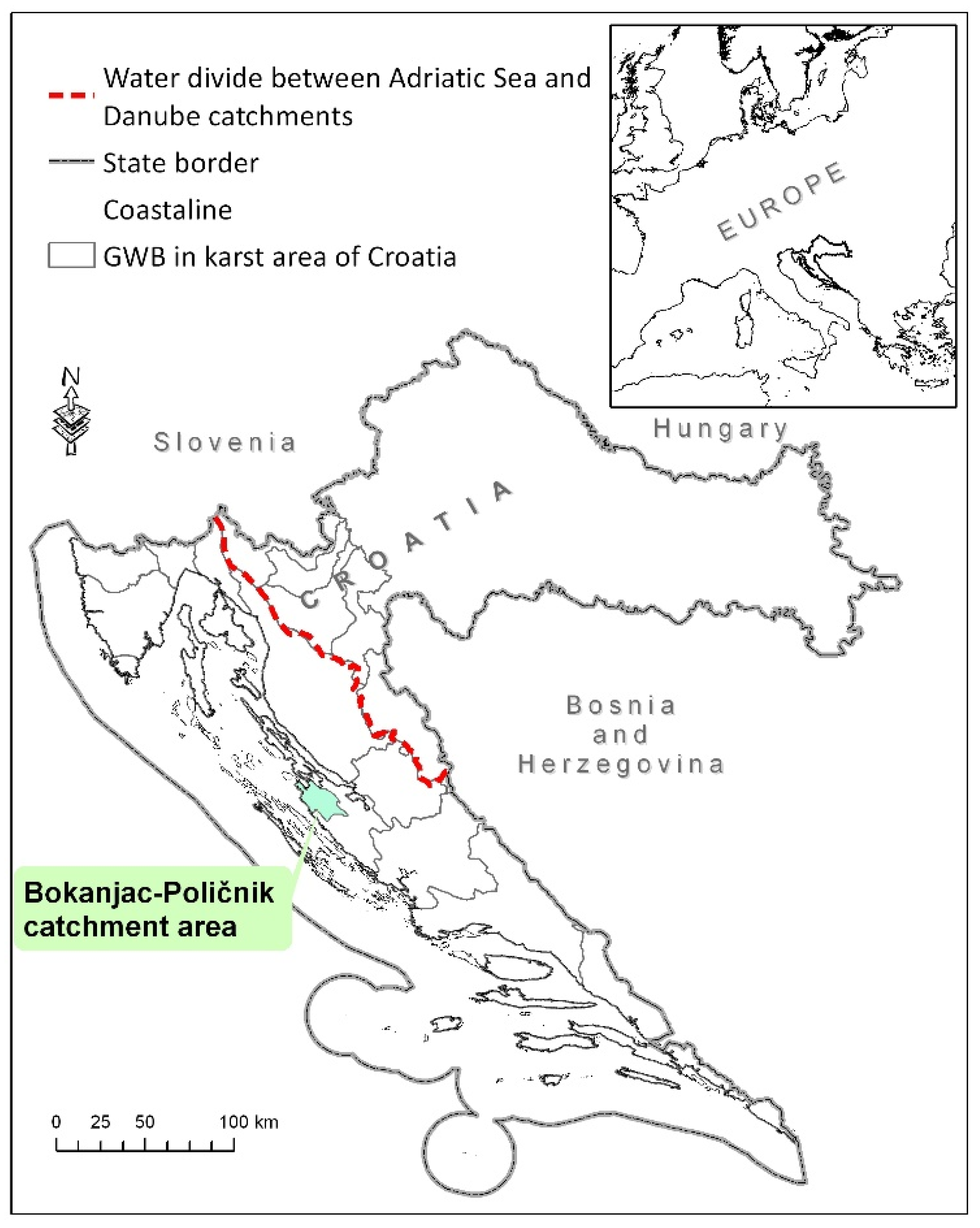
Detecting the seawater intrusion in coastal karstic aquifers in Croatia is one of the measures in the water management of such areas and is the main topic of this paper. In coastal areas, there are numerous problems with occasional increases in salinity at pumping stations as a consequence of excessive groundwater exploitation, but there are also numerous occurrences of brackish leakage water at coastal springs in completely natural conditions. In order to define the national criteria for determining the risk of salinization, the groundwater body (GWB) Bokanjac-Poličnik was selected as a pilot area. In that area, operational monitoring was carried out by drilling additional wells and placing measuring devices in them along the depth of the aquifer, with additional surface water monitoring, hydrological and hydrogeological analysis of the obtained data. Analysis of hydrochemical indicators that are used for detecting the seawater intrusion will be presented on the example of the GWB Bokanjac-Poličnik. The given results will provide a better understanding of the salinization process in the case study area.
2. Case Study Bokanjac-Poličnik
Bokanjac-Poličnik is the coastal karstic aquifer located in the area called Ravni kotari, which is part of the northern Dalmatia in Croatia (
Figure 1). Bokanjac-Poličnik covers an area of 302 km
2 [
20].
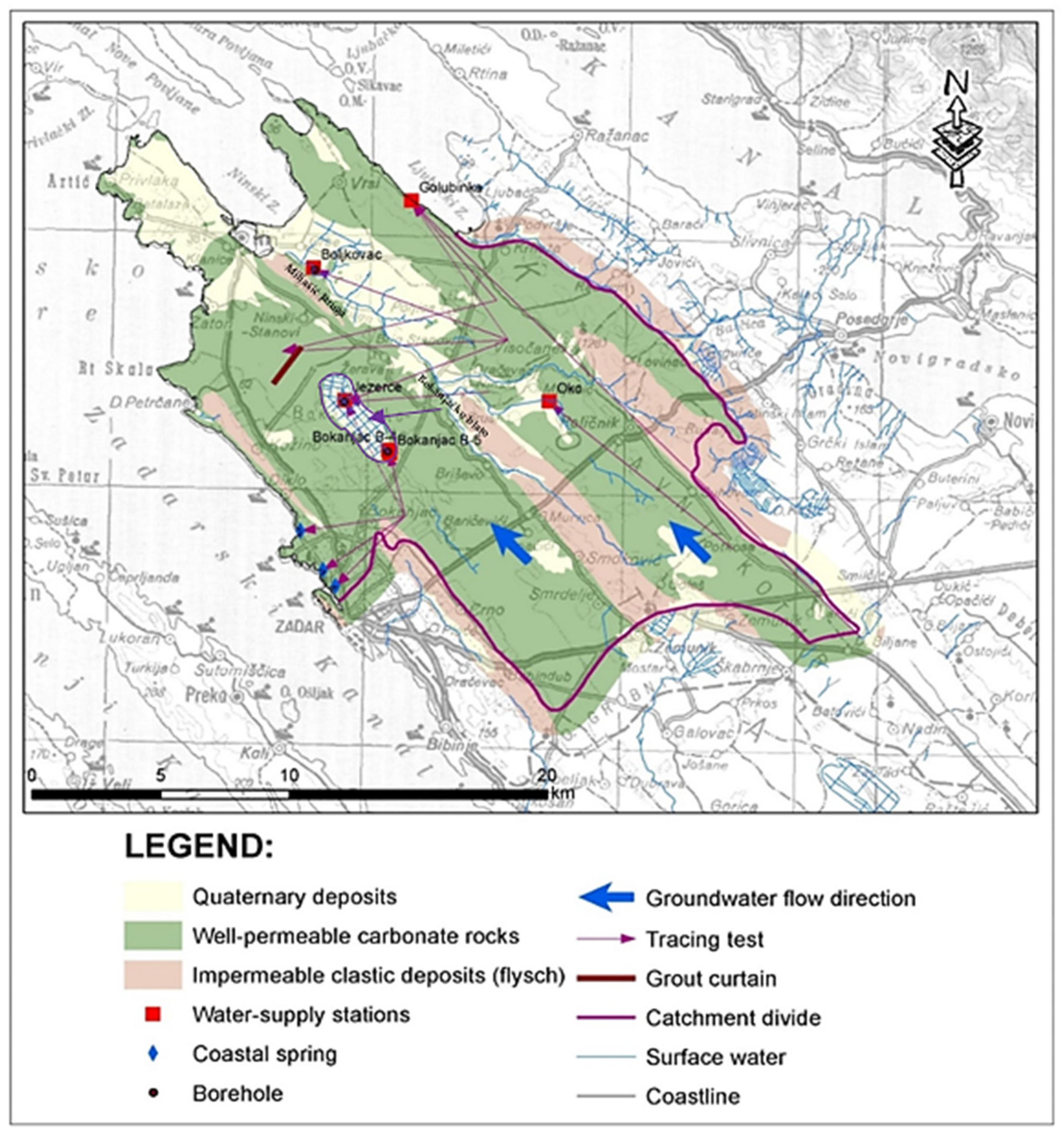
The Bokanjac-Poličnik aquifer is formed in the carbonate rocks of the Adriatic carbonate platform with a characteristic scaly structure, in which water-permeable carbonate rocks and water-impermeable clasts alternate (
Figure 2) [
21]. The core of the anticlinal parts is built of limestones of the Upper Cretaceous age, and the synclinal flysch of the Paleogene age. The spread of scaly forms is northwest–southeast, and it is also the direction of spreading of rocks of different hydrogeological characteristics [
22].
In the area of the Bokanjac-Poličnik catchment area, several tracing tests were performed for the purpose of determining sanitary protection zones, determining the catchment area of water supply facilities, but also assessing the impact of individual facilities on water pumping stations and water supply springs/wells (
Figure 2). Groundwater in the Bokanjac-Poličnik catchment area flows parallel or subparallel to geological structures in the southeast–northwest direction in two separate branches. The first branch is on the northeast side of the flysch barrier that stretches from Smoković to the northwest following the provision of structures. The majority of groundwater of this branch feeds the coastal well Golubinka and the water pumping station Boljkovac. Only after the zone where the flysch barrier emerges does the groundwater move perpendicular to the spread of the structures, towards the Jezerce water pumping station. The second branch drains towards Bokanjačko blato and further towards Boljkovac and the northwestern part of the structure where groundwater diffusely infiltrates into the sea near Zaton and Nin.
The main surface watercourse in the catchment area is Miljašić jaruga and, in addition to its natural immediate basin, surface waters also characterize its most important tributary, Bokanjačko blato, with which it is artificially connected by a hydrotechnical tunnel. The natural conditions of surface and groundwater dynamics have been partially changed by the construction of a tunnel which, since 1963, drains the floodwaters of Bokanjačko blato towards Miljušić jaruga, which prevents the formation of temporary lake in Bokanjačko blato [
20]. Prior to the construction of this facility, the area of Bokanjačko blato was occasionally flooded and slowly swallowed into temporary swallow-holes in the northwestern part of the field. With the construction of the tunnel, the area of Bokanjačko blato is no longer flooded, thus enabling permanent agricultural activity in this area. Additionally, irrigation and drainage canal systems have been built for this purpose. However, this intervention also changed the conditions of groundwater recharge, i.e., reduced the positive impact of infiltrated surface waters on the hydrogeological conditions in the aquifer. Drainage of high waters of Bokanjačko blato towards Miljašić jaruga by the hydrotechnical tunnel affected the condition of groundwater in the area of Bokanjačko blato. A decrease in the pumping capacity of wells in the area of Bokanjačko blato was observed due to reduced infiltration of aquifers with flood waters.
With reduced recharge of the aquifer, caused by drainage of surface water towards the Miljašić jaruga, the problem of the occasional impact of the sea on the Jezerce well began to appear, and even impact, although minimally, the Bokanjac pumping station. To prevent this, in the mid-1970s a grout curtain about 40 m deep was built downstream from Bokanjačko blato [
20]. The main function of this facility was to cut fracture systems in the aquifer, i.e., to prevent salinization of water supply facilities in Bokanjačko blato area (Jezerce, Bokanjac), as well as a deeper intrusion of salt seawater into the aquifer. New experiences in hydrogeology have shown that this was too shallow a facility, considering that the depth of karstification of the aquifer and the possible dynamics of groundwater and sea intrusion into the karst underground are at greater depths than the facility depth. This was also shown by the subsequent temporary increased concentrations of chlorides and sulfates at the water supply facilities in Bokanjačko blato, i.e., the occurrence of salinization of that part of the aquifer [
20].
Water facilities that are included in the water supply system for the City of Zadar and surrounded areas are Bokanjac, Golubnika, Boljkovac, Jezerce, and Oko.
Monitoring of the groundwater level dynamics at Bokanjačko Blato was fragmentary during the short time periods. According to the European Water Framework Directive [
23] and as a result of the operational monitoring established due to the salinization problems defined in River Basin Management Plan 2016–2021 [
24], for the area of Bokanjac-Poličnik, four piezometric wells about 60 m below sea level were drilled. In the drilled wells, a system of automatic monitoring of the aquifers by depth, electrical conductivity, temperature, and groundwater level was installed. Additionally, the operational monitoring was installed in all active water supply wells in the catchment area (Bokanjac B-4 and B-5, Jezerce, Boljkovac, and Oko).
3. Data and Methodology
The most widely used salinity indicators of coastal aquifers are chloride and sulfate concentrations in groundwater and the value of electrical conductivity [
25].
Data for the analyses were collected by operational and surveillance monitoring of the water-supply company Zadar (
Table 1) [
13].
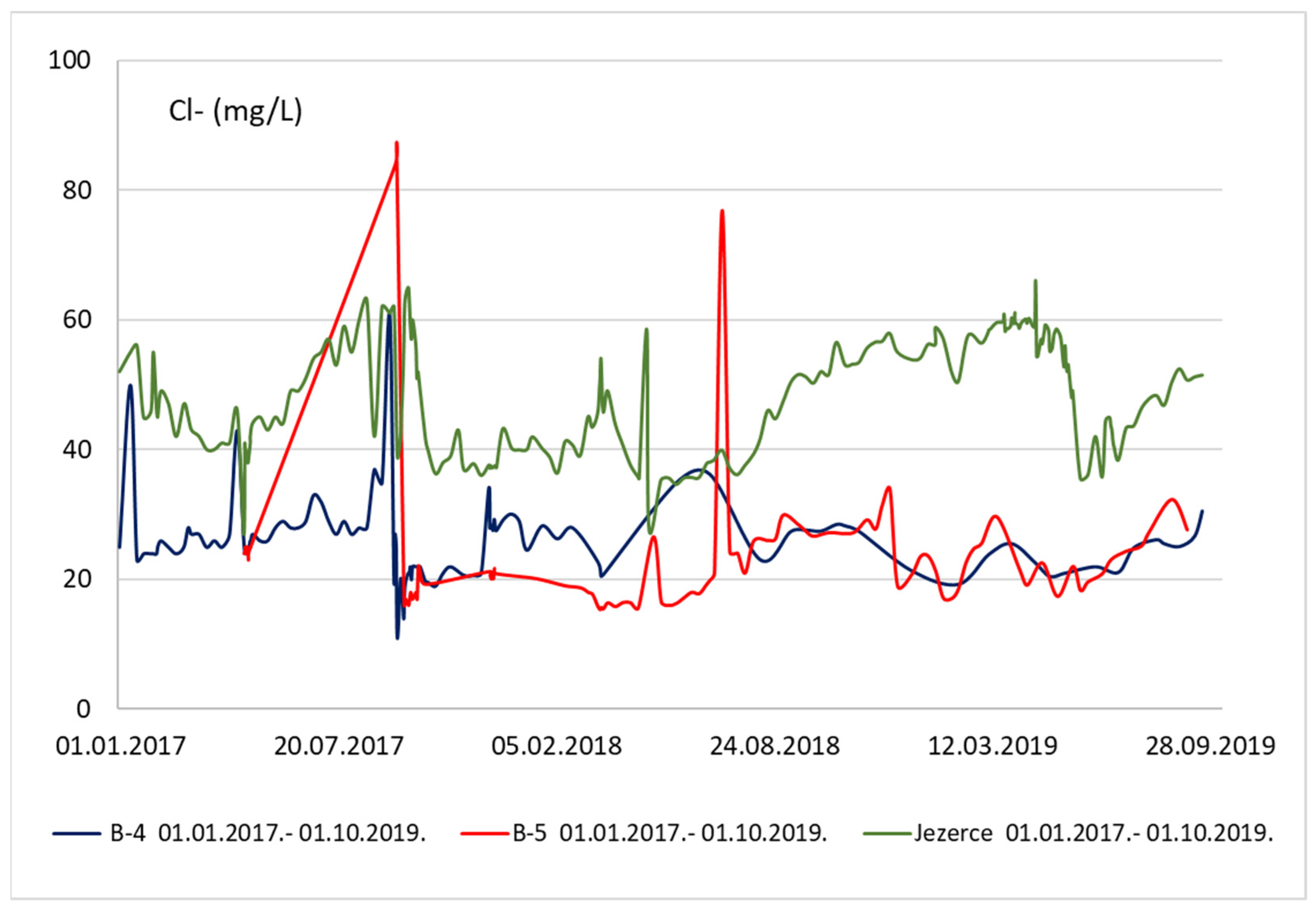
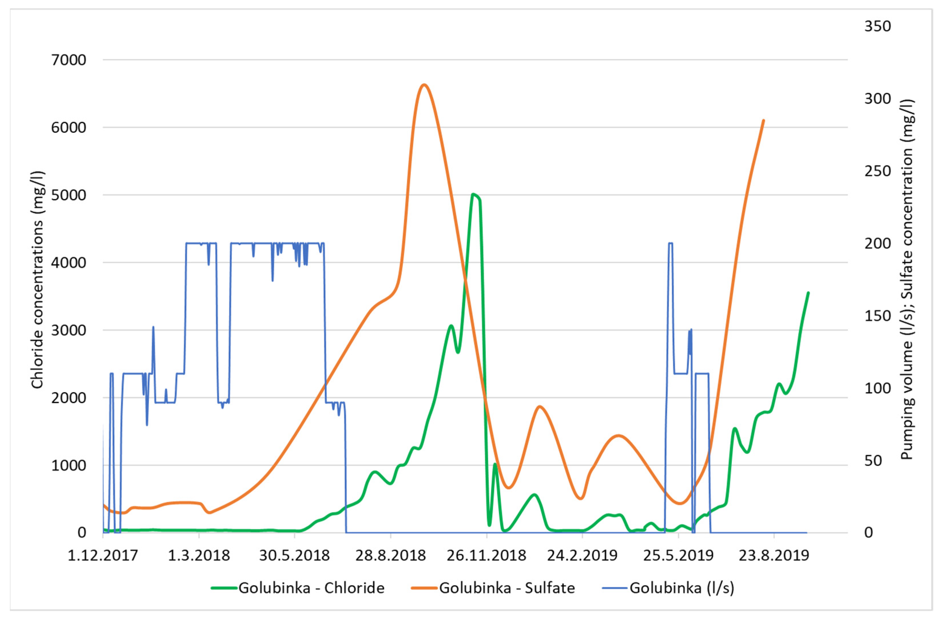
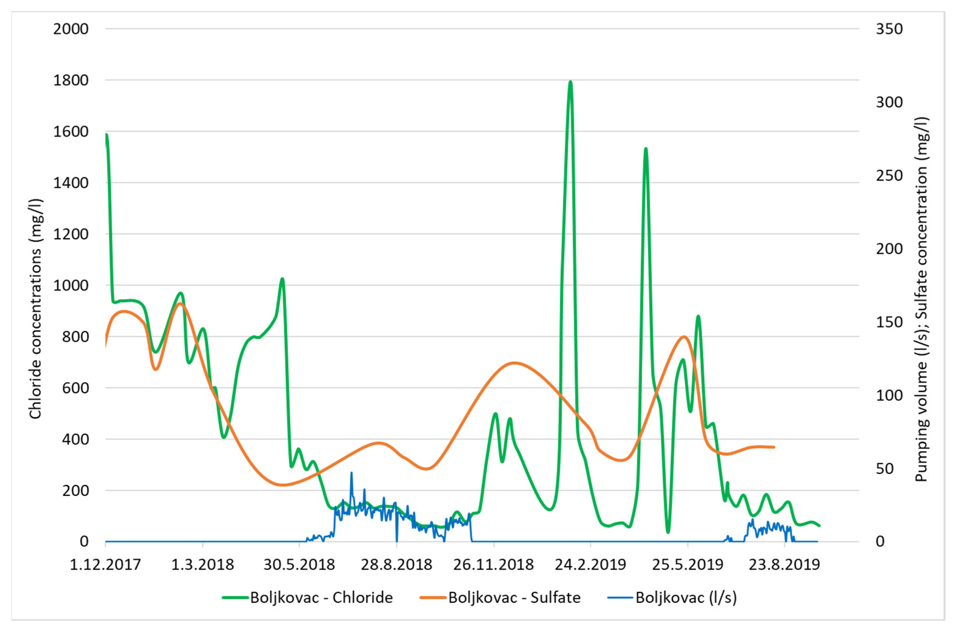
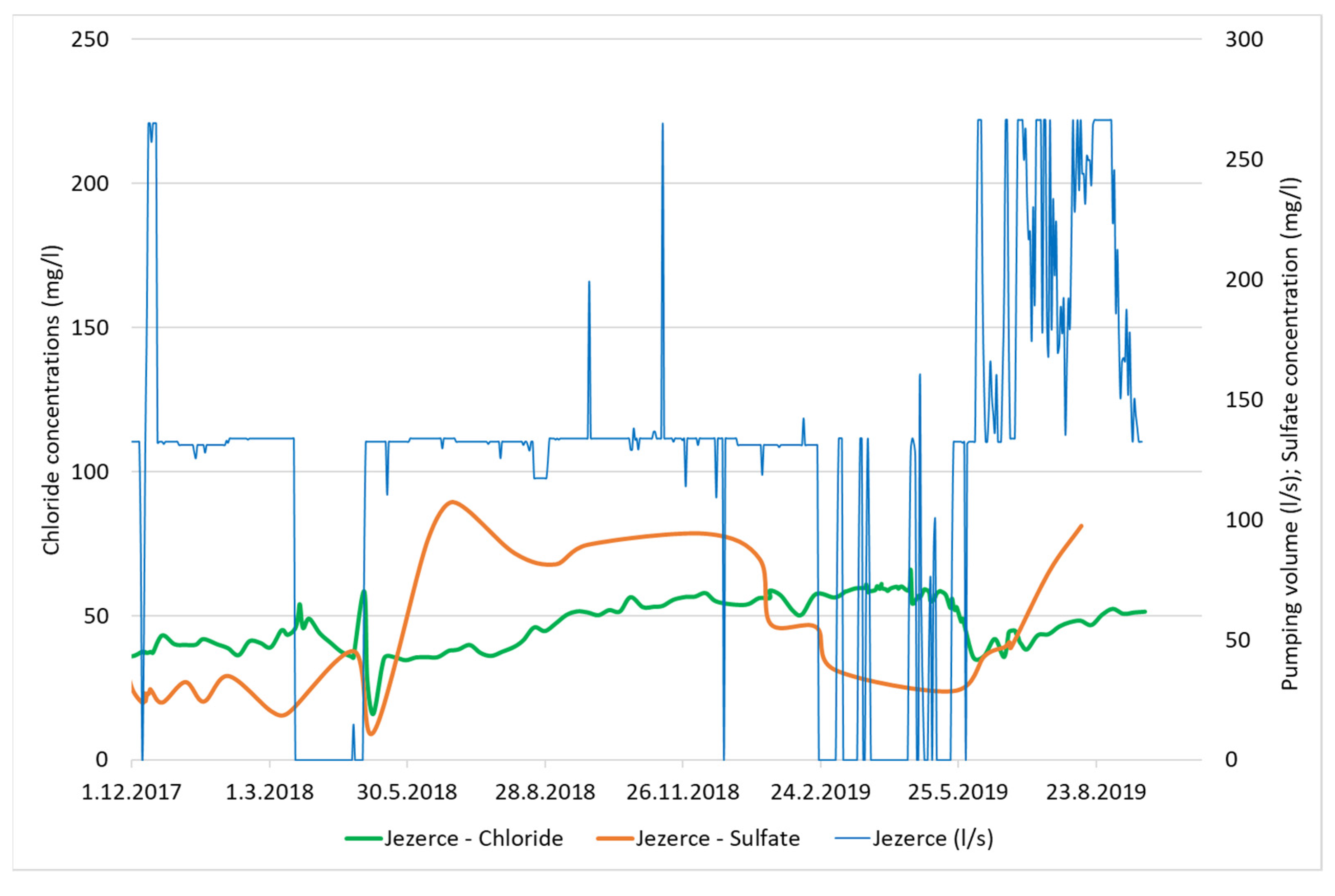
In the Bokanjac-Poličnik catchment area, salinization occurs most often, almost every year, at two water supply facilities, Golubinka and Boljkovac (
Figure 3). This occurs in situations when Golubnika spring yield decreases during the dry season, and in the Boljkovac in conditions of significant precipitation after dry periods. Increases in salinization due to pre-exploitation also occur at the Jezerce water intake, but only in extremely dry years. Due to the difference, chloride concentrations are shown for all case study wells (
Figure 3 and
Figure 4).
Standard to ensure protection against short-term exposure to pollution, the Maximum Allowable Concentration (MAC) of the substance concerned, i.e., the maximum for any single measurement, is proposed in order to ensure protection against short-term exposure, i.e., pollution peaks [
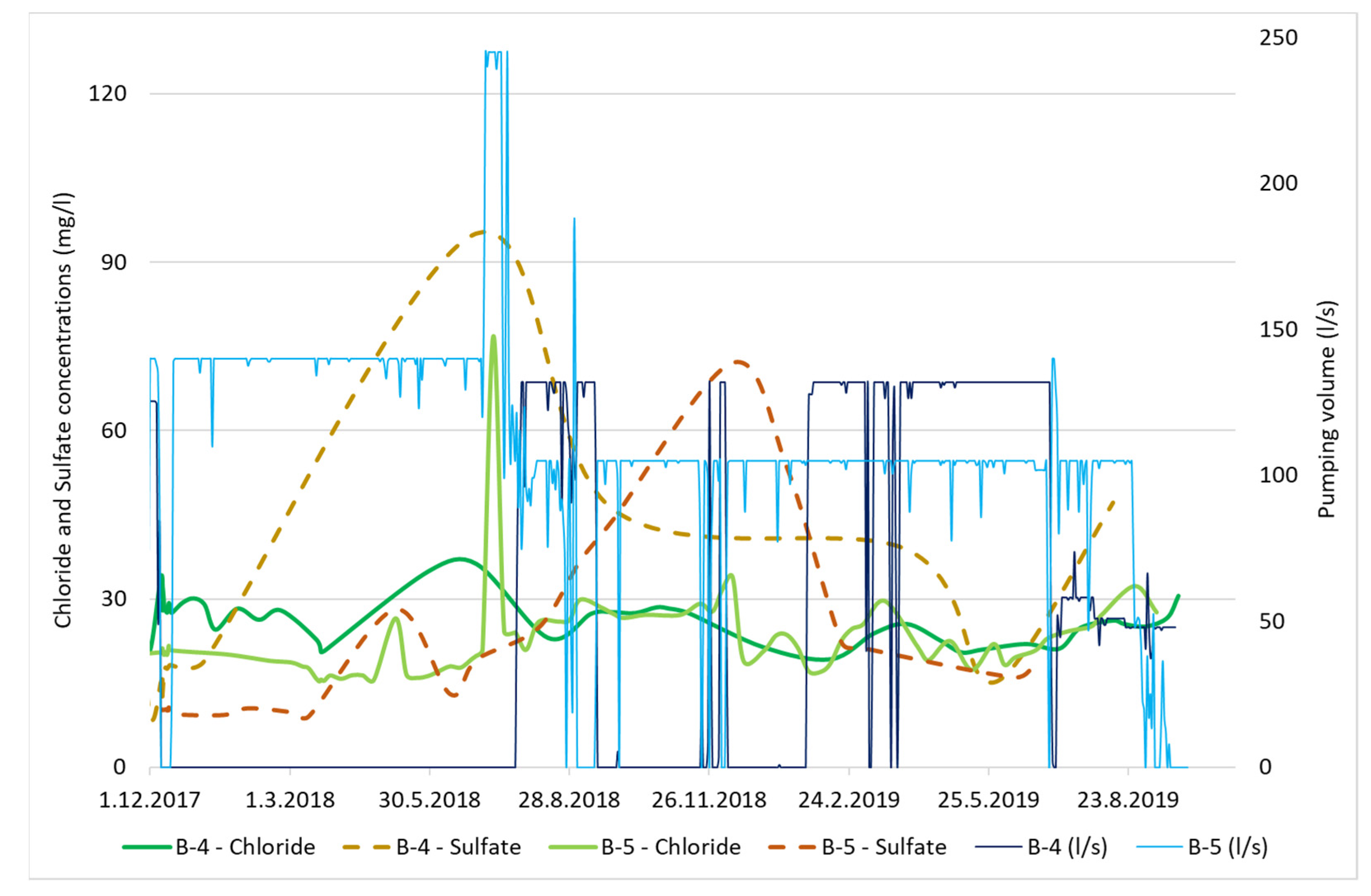
23]. Occurrences of increased seasonal chloride contents above the MAC values at water supply sources from the Bokanjac-Poličnik catchment area characterize all water supply sources except wells B-4 and B-5, where slight increases in chloride content occur very rarely and are far below the MAC limit.
Existing regulations in Croatia for the MAC content of chloride in drinking water is 250 mg/L, and the electrical conductivity is 2500 μs/m at 20 °C [
26]. Increases in chloride content occur during long dry periods in the form of gradual increases in chloride content or when significant precipitation appears during long dry periods. Such precipitation causes increased inflows in parts of karst aquifers, and there are sudden changes in hydraulic conditions which are manifested in changing the boundaries of salt and freshwater and pushing saline water from deeper and more distant parts of aquifers through their lowest hydraulic resistance.
According to the chemical composition, the water from wells B-4 and Jezerce belongs to the Ca-HCO
3 and CaMg-HCO
3 hydrochemical types [
27]. However, sometimes waters of Jezerce belong to Ca-HCO
3Cl hydrochemical type due to seawater intrusion.
The results of several hydrochemical analyses indicate that the Golubinka and Boljkovac wells are under the constant influence of seawater, while at the Jezerce water pumping station salinization occurs occasionally [
13,
20,
28]. Given analysis shows that the wells of the Bokanjac water pumping station are in the zone of influence of the sea water and, due to over-pumping, can also lead to an increase in chloride concentration [
28].
In the analysis of groundwater quality for the period from 1 December 2017 to 30 September 2019, data on chloride and sulfate concentrations of the Zadar were used. In the considered period, chloride concentrations exceeded the MAC values only at the Golubinka well and the Boljkovac water pumping station.
Analysis of the chlorine concentrations in groundwater in various parts of that area was conducted to demonstrate this increase due to two possible reasons—the natural conditions of circulation of groundwater and sea in the wider area of their leakage, as well as depletion of water supplies in adverse hydrological conditions. Additionally, increases in chloride content occur during prolonged droughts periods in the form of gradual rise in chloride content or during such prolonged droughts periods as a result of significant precipitation [
29].
4. Results and Discussion
The impact of salinization is most felt at the Boljkovac pumping stations and at the Golubinka karst spring, and they are located closest to the seacoast. The impact of salinization on the Jezerce pumping station is much smaller, while on Bokanjac this impact is the smallest as it is located furthest from the seacoast. Therefore, this basin can be divided into the coastal zone where the impact is greatest (Boljkovac and Golubinka) and the inner zone of aquifer where this impact is much smaller (Jezerce and Bokanjac). At the Boljkovac and Golubinka pumping stations, an increase in salinity occurs during rainy periods when the mixing zone of salt and fresh water expands due to large inflows from the hinterland. The Jezerce pumping station behaves very similarly, but this impact is much smaller and the impact of pumping during the summer dry periods is also felt, which causes a limited conical uplift of salinity from the deep part of the aquifer. At the Bokanjac pumping station (B-4 and B-5), rainy periods do not cause problems with salinization, but excessive pumping affects slightly higher concentrations of chloride and sulphate.
Average precipitation in the catchment area for the period 1961–2018 is 911.2 mm [
13]. Hydrological years 2017/18 and 2018/19 during which operational monitoring was carried out fall into average years according to the amount of precipitation (980 mm and 852 mm) [
13].
In the Boljkovac water intake, the greatest salinization occurs when larger waters appear. Comparison diagrams of chloride and sulfate concentrations with the pumping volumes for each water well are given in
Figure 5,
Figure 6,
Figure 7 and
Figure 8.
From given comparison diagrams (
Figure 5,
Figure 6 and
Figure 7) it can be seen that on Boljkovac, Golubnika, and Jezerce water intake, the amount of pumping has no significant impact on the rise of the chloride and sulfate concentrations. Although given analysis shows the certain association of pumping, water levels, and increased chloride content. This relationship manifests itself by the raise of the water pumping and chloride concentrations in smaller quantities. It is possible that in conditions when chlorides do not exceed the MAC condition, the amount of pumping effect on freshwater overpressure in marginal parts of the aquifer and saline seawater enters the source zone. Both B4 and B5 at the Bokanjac well exhibited a connection between pumping volumes and chloride and sulfate concentrations, as seen in
Figure 8. Additionally, it can be seen that higher values of chloride and sulfate concentrations appear in summer months when pumping volumes are higher due to the higher consumption caused by tourism season. At the time of maximum measured concentration chloride on B-5, the well was pumped at 245 L/s and, by reducing the amount of pumping to 120 L/s, reduced the chloride concentration to normal values of about 25 mg/L [
13]. There are many ways of investigation regarding the flow dynamics processes, transport, and distribution of particles in coastal zones that found preferential paths for seawater intrusion in costal aquifers, but most of them are based on mathematical models [
30,
31]. Coastal reservoirs contribute to the alleviation of water shortages in coastal zones, and their water quality is greatly affected by inland groundwater flow and tides. [
32] Some studies take into consideration water/salt exchange processes between the coastal reservoir and its adjacent aquifers and took deep pools and tidal forcing into consideration [
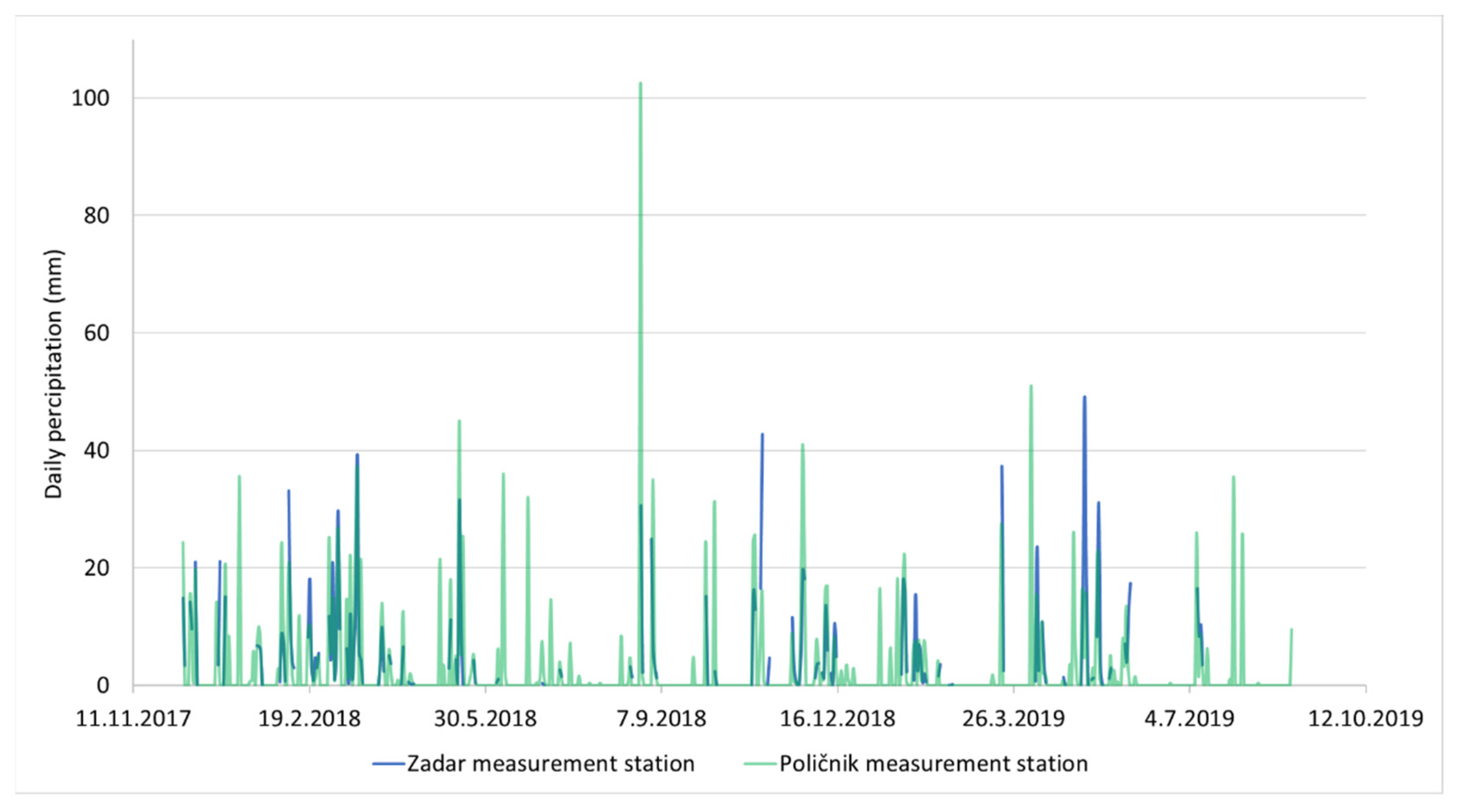
33]. Measurement of hydrochemical indicators of salinity is easier and cheaper way to have an insight into real situation in given time but for better understanding of salinity processes, the experimental mathematical models are needed. In order to explain natural salinization processes that occur on case study area, precipitation values are collected from Croatian Meteorological and Hydrological Service and shown on
Figure 9 [
34].
Comparison between
Figure 9 where precipitation values are shown, and chloride concentrations on
Figure 6,
Figure 7 and
Figure 8 shows that shortly after the highest values of precipitation, the chloride concentration raises. On 26 August 2018 at Poličnik station, precipitation in amount of 102.5 mm was measured, and at Boljkovac and the Golubinka well chloride concentrations began to rise. Regarding sulphate concentrations on Jezerce and Bokanjac wells, it can be seen that they are on the rise in days when precipitation values are above 20 mm.
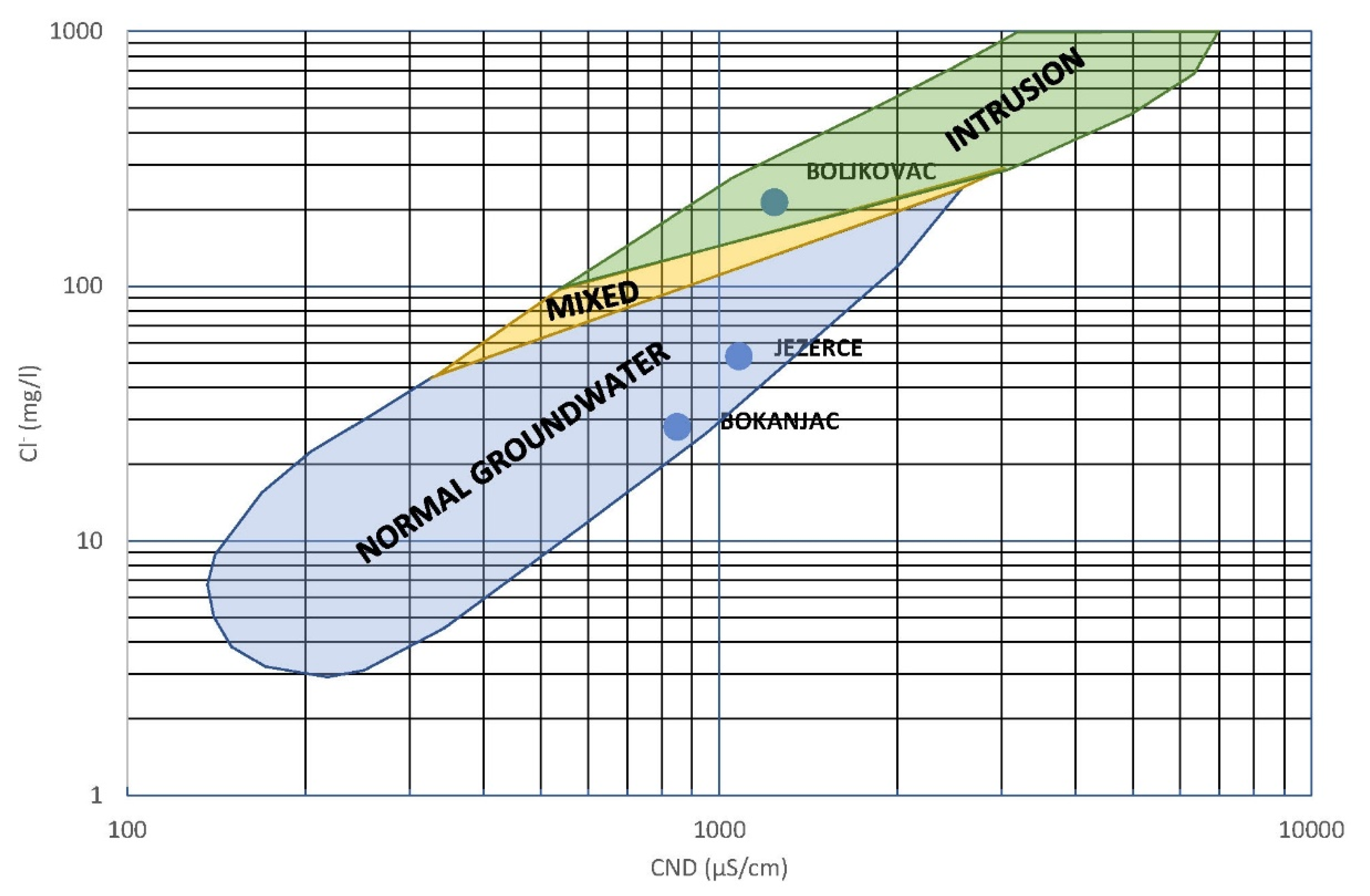
Additionally, comparisons of the values of electrical conductivity in opposition to chloride concentrations for Bokanjac, Jezerce, and Boljkovac are made. Golubinka spring have different conditions of the salinization and it is not included into comparison given on
Figure 10.
The greatest impact of salinization from the observed water body was recorded at the Boljkovac pumping station. This was confirmed by operational monitoring [
13,
24] through which the value of electrical conductivity was measured by the depth of the aquifer every ten minutes. The Jezerce pumping station is located close to the salinity zone, which is confirmed by slightly higher values of electrical conductivity. The farthest from the sea, and thus from the influence of salinization, is the Bokanjac (B-4 and B-5) pumping station, where the values of electrical conductivity are slightly higher than in other wells, but there is no significant influence of salinization.
The analyzed parameters indicate that the Bokanjac pumping station is located in the freshwater zone (
Figure 10), but salinization is also possible during long dry periods and in conditions of over pumping for higher consumption demand. Jezerce is also in the freshwater zone, but close to the mixed zone, and at the Jezerce water supply facility increasing of chloride and sulphate concentrations in groundwater occurs temporarily. Boljkovac is under the intrusion of sea water influence (
Figure 10), and almost every year strong salinization occurs on the water supply facility.
5. Conclusions
Due to the scaly formation of the Adriatic coast and the openness of various geological structures, the contact between salt seawater and fresh ground water is easily enabled. This creates a problem due to the intrusion of salt seawater into coastal aquifers which ultimately leads to salinization at springs and wells used in water supply systems. There is no sharp mixing limit, but there are fresh and saltwater mixing zones whose positions and sizes depend on the hydraulic gradient and the geological structure of the aquifer as well as on other factors that can contribute to the movement of this zone into deeper parts of coastal aquifers.
Taking into consideration that GWB Bokanjac-Poličnik is pronounced “at-risk” according to the River Basin Management Plan 2016–2021, due to occasional problems with salinization, constant monitoring and a better understanding of the seawater intrusion is needed.
It can only be assumed, due to the accelerated rise of the negative impact of climate change, as well as the rise of tourism, that their effect on seawater intrusion into GWB Bokanjac-Poličnik will be increased in the future. This refers to higher water consumption that will lead to higher pumping volumes from the wells/springs that are already at risk of salinization. Pumping usually causes a conical rise of saltwater and a mixing limit towards the water supply object. Depending on the vertical, but partly also the horizontal permeability of the rocks, the inflow of water from the hinterland and the depth of the wells can be larger or smaller. In some cases, the exploitation of groundwater causes more frequent and more pronounced salinization phenomena at water intakes where such phenomena occasionally occur in natural conditions.
Results conducted in this research give a clear view into a situation with seawater intrusion on five wells/spring on the case study site. Comparison of the chloride, sulfate concentrations with pumping volumes, as well as the precipitation values for the same period, shows connection between high intensity precipitations and rise of the hydrochemical indicators that indicate salinization. Given results lead to the conclusion that constant monitoring with telemetry and an early alert system is needed in order to reduce water pumping and water consumption in a timely manner. This will provide enough time to avoid complete salinization of these wells as well as other wells on similar localities.


