Article

Assessing Climate Driven Malaria Variability in Ghana Using a Regional Scale Dynamical Model

by
Ernest O. Asare
* and
Leonard K. Amekudzi
Department of Physics, Kwame Nkrumah University of Science and Technology, Kumasi 00233, Ghana
*
Author to whom correspondence should be addressed.
Submission received: 31 December 2016 / Revised: 22 February 2017 / Accepted: 23 February 2017 / Published: 5 March 2017

Abstract

:
Malaria is a major public health challenge in Ghana and adversely affects the productivity and economy of the country. Although malaria is climate driven, there are limited studies linking climate variability and disease transmission across the various agro-ecological zones in Ghana. We used the VECTRI (vector-borne disease community model of the International Centre for Theoretical Physics, Trieste) model with a new surface hydrology scheme to investigate the spatio-temporal variability in malaria transmission patterns over the four agro-ecological zones in Ghana. The model is driven using temperature and rainfall datasets obtained from the GMet (Ghana Meteorological Agency) synoptic stations between 1981 and 2010. In addition, the potential of the VECTRI model to simulate seasonal pattern of local scale malaria incidence is assessed. The model results reveal that the simulated malaria transmission follows rainfall peaks with a two-month time lag. Furthermore, malaria transmission ranges from eight to twelve months, with minimum transmission occurring between February and April. The results further reveal that the intra- and inter-agro-ecological variability in terms of intensity and duration of malaria transmission are predominantly controlled by rainfall. The VECTRI simulated EIR (Entomological Inoculation Rate) tends to agree with values obtained from field surveys across the country. Furthermore, despite being a regional model, VECTRI demonstrates useful skill in reproducing monthly variations in reported malaria cases from Emena hospital (a peri urban town located within Kumasi metropolis). Although further refinements in this surface hydrology scheme may improve VECTRI performance, VECTRI still possesses the potential to provide useful information for malaria control in the tropics.

1. Introduction

Malaria is hyperendemic and poses a significant public health challenge in Ghana. Despite recent scaled up malaria treatment and control intervention strategies, malaria still remains the leading cause of morbidity and mortality among the entire population. For example, between 2000 and 2011, malaria alone accounted for an average of about 40% of all out-patient attendance (OPD) in public health facilities [1,2,3]. Similarly, in 2011, the Ghana Health Service (GHS) [3] report indicated that suspected malaria cases accounted for about 40.2% outpatient morbidity, 35.2% hospital admissions and 18.1% of all recorded death at public hospitals. Most importantly, actual malaria cases are likely to be higher than the reported cases since private health facilities and home treatment (self medication) of the disease using both orthodox and traditional medicine are not taken into account.
In addition to health implications, malaria also presents substantial economic and developmental challenges in Ghana. Asante and Asenso-Okyere [4] found a negative association between malaria cases and gross domestic product (GDP). In a related model study, Sicuri et al. [5] estimated annual total cost of malaria treatment and prevention for children under five years to be US$37.8 million in 2009. In addition, they estimated the expenditure for treating a single malaria episode to range between US$2.89 and US$123 depending on disease severity. Furthermore, a large fraction of Ghana’s health budget goes to treatment and prevention of malaria. For instance, the estimated budget for National Malaria Control Programme (NMCP) strategic plan for effective malaria prevention and treatment between 2008 and 2015 was US$880 million [6]. In addition, the disease is adversely affecting sustainability of the National Health Insurance Scheme (NHIS) due to high reported cases at the various hospitals across the country [7].
On the household level, Akazili et al. [8] found the cost of treatment of malaria to be about 34% and 1% of the household’s income for the poor and the wealthy, respectively, in the Kassena-Nankana district of northern Ghana. More recently, Sicuri et al. [5] estimated that about 55% of the total cost of malaria treatment in 2009, which ranged between US$ 7.99 and US$ 229.24 per malaria episode, were borne by the patient. These clearly show that successful implementation of an effective malaria control program will have a huge socio-economic and public health impact on the country.
Similar to sub-Saharan African countries, Anopheles gambiae sensu lato complex and Anopheles funestus are the main malaria vectors in Ghana [9,10,11,12,13,14]. The distribution of these vectors is heterogeneous and somehow follows climate and ecological conditions [9]. An. gambiae s.s., An. arabiensis and An. melas are the three species within the Anopheles gambiae sensu lato complex found in Ghana [10,11]. The An. gambiae s.s. vector predominates the complex and distributed throughout the country [12]. However, the other two vectors have limited distribution within the country. An. arabiensis predominates in the savanna region while An. melas are confined along the coast [11,12]. Regarding An. funestus, Dadzie et al. [14] found An. funestus sensu stricto as the only malaria transmission vector in the sub group found in the country. Although An. funestus sensu stricto are found all over the country, they are the predominant and important vectors in the savanna ecological zone [14].
Three out of four main species of human malaria parasites are present in Ghana. Plasmodium falciparum, the most severe and life threatening, is predominant in the country, accounting for about 80% to 90% of all malaria infections. This is followed by Plasmodium malariae, which is responsible for between 20% and 36% of malaria cases while Plasmodium ovale is less prevalent, accounting for less than a percent (about 0.15%) of all malaria parasitemia [4,15]. Moreover, mixed infections of Plasmodium falciparum and Plasmodium malariae are also common. For instance, in Accra, Klinkenberg et al. [16] detected a single case of mixed infection of Plasmodium falciparum and Plasmodium malariae for a three-month study period among children between 6 and 60 months of age. However, 258 out of the 261 infections detected were due to Plasmodium falciparum with two cases of Plasmodium malariae. Similarly, in the Kassena-Nankana District located within the savanna zone, Koram et al. [17] identified 963, 63 and 36 cases of Plasmodium falciparum, Plasmodium malariae and mixed infections of the two, respectively. In addition, Dinko et al. [18] found all the three species in the Ahafo Ano South District of the Ashanti region, which is within the forest ecological zone.
Heterogeneities in malaria transmission dynamics across the four agro-ecological zones in Ghana have been reported. These differences in malaria incidence are due to a combination of factors such as vector and parasite distribution [12,19], climate drivers [20,21], environment and land use change [22,23], socioeconomic factors [24] and human host behavior. For instance, within the coastal, forest and transition zones with bimodal rainfall regime, malaria transmission tends to be perennial and intense but with slightly higher cases during the wet season [20,21,25]. In the savanna zone with unimodal rainfall and a long dry season, malaria transmission, although intense, shows more pronounced seasonality relative to the other zones. For example, Appawu et al. [10] observed transmission peaks between June and October in the Kassena-Nankana District in northern Ghana. Similarly, in the same district, Baird et al. [26] found malaria incidence density of five, which increased to seven infections/person/year in the dry and wet seasons, respectively, among children under two years. Despite this, non-climatic factors such as urban agriculture, open drains and irrigation, among others, introduce local hot spot transmission within the various ecological zones, which modify local disease dynamics.
Rainfall, temperature, wind speed and relative humidity are the key climate drivers that influence the spatio-temporal malaria transmission. Areas like Ghana, where mean temperatures are within the range that supports malaria transmission, variations in rainfall play a key role in understanding disease dynamics. Consequently, most studies attempt to associate malaria incidence with rainfall. However, contrasting results have been observed. For instance, the Atonsu (urban), Emena (peri-urban) and Akropong (rural) towns within the Ashanti region of Ghana, Tay et al. [27] observed weak but variable relationships between rainfall and hospital morbidity data at various time lags. Klutse et al. [28] found a poor correlation between rainfall and malaria at Winneba (coastal) and Ejura (transition) zones. Interestingly, a strong but negative correlation was observed for these two locations with a two-month lag time between malaria and rainfall. In the forest zone, Danuor et al. [29] observed a strong negative correlation between rainfall and malaria incidence. Similarly, in the forest zone, Krefis et al. [30], using a regression model, found about two-month time lag between rainfall and malaria incidence. This nonlinearity between rainfall and malaria intensity has been observed elsewhere [31,32].
Due to this strong nonlinear relationship between malaria incidence and rainfall, a model that incorporates surface hydrology (e.g., the International Centre for Theoretical Physics, Trieste (VECTRI) Tompkins and Ermert [33]) is likely to perform better in predicting malaria incidence relative to models that use rainfall as proxy for aquatic habitats. For instance, rainfall in addition to local scale hydrological conditions control mosquito developmental habitat dynamics and, to some extent, its productivity [34,35]. More importantly, in Ghana, studies linking climate fluctuations and malaria transmission across the various agro-ecological zones are limited. The few available studies are based on a single or at most two ecological zones and over a short time period [27,28,29]. Thus, it becomes clearly difficult to understand malaria transmission dynamics over the entire country.
The aim of this paper is to investigate the spatio-temporal variability in malaria transmission patterns over the four agro-ecological zones using the VECTRI model [33] driven by rainfall and temperature datasets obtained from the 22 synoptic stations operated by the Ghana Meteorological Agency (hereafter GMet) between 1981 and 2010. Although the potential of using VECTRI to give advance warning about malaria incidence has been explored [36], this model has never been evaluated on a local scale. Consequently, the potential of the model to predict local scale seasonal variability in malaria transmission is assessed using monthly recorded malaria cases from Emena hospital (a peri urban town located within Kumasi metropolis). Results evaluation demonstrates the ability of the VECTRI model to provide malaria early warning information over Ghana, and the model also possesses the potential to predict malaria seasonality at a local scale.

2. Method and Data

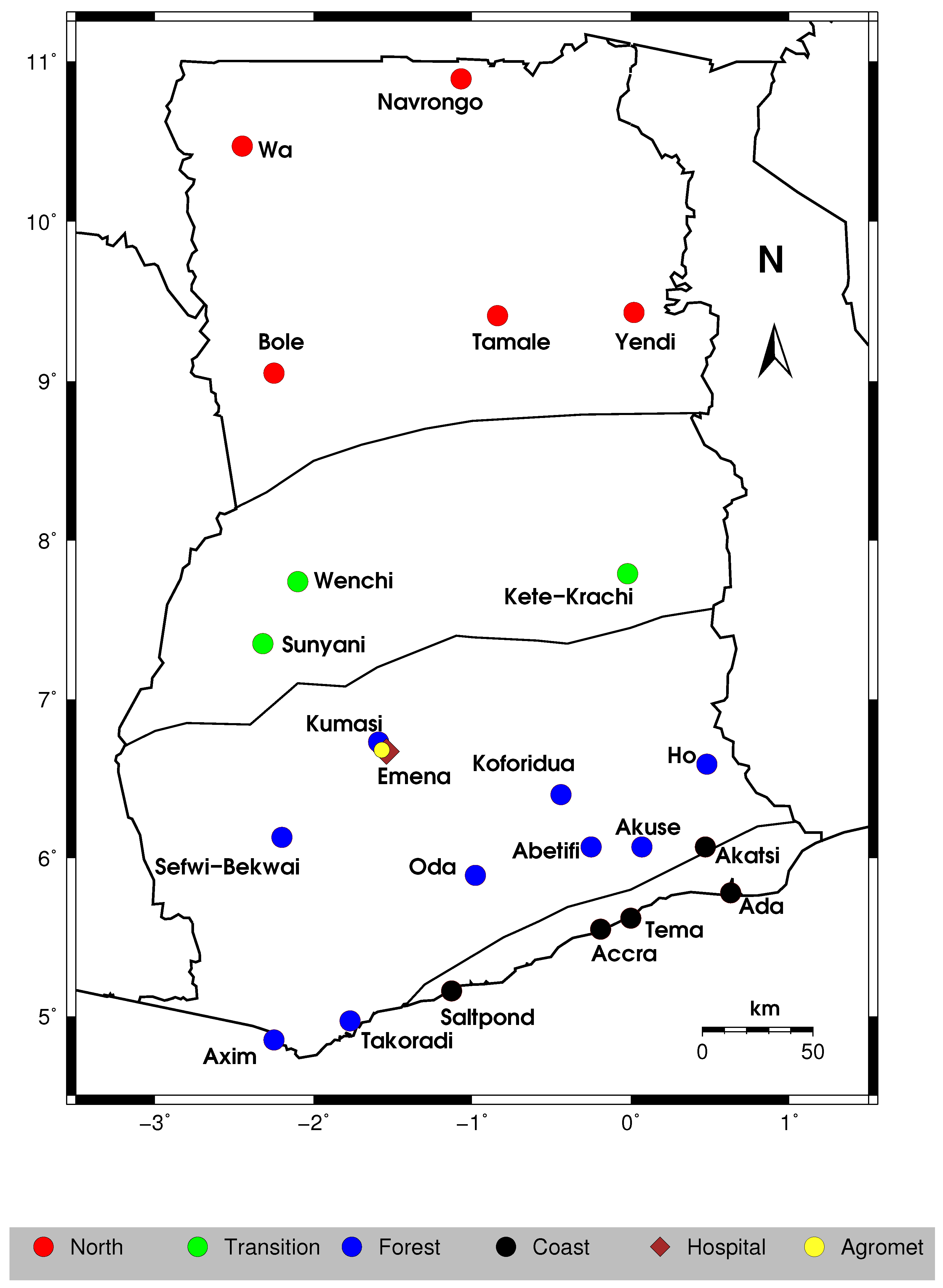
2.1. Study Area and Data

In this study, daily rainfall and maximum and minimum temperatures were obtained from GMet (Accra, Ghana). The 22 GMet synoptic stations data over the country for a 30-year period (1981–2010) were considered. The name and location of these stations across the four agro-ecological zones are shown in Figure 1. These data were used as inputs to drive the VECTRI model to simulate climate-driven malaria transmission dynamics over the country. In addition, daily observations of the same variables were obtained from GMet operated agro-meteorological station (Agromet) located at Kwame Nkrumah University of Science and Technology (KNUST) campus in Kumasi (Figure 1) to drive the model to evaluate VECTRI performance on a local scale. The Agromet station is located about 4 km from the Emena hospital.
Rainfall is highly variable in Ghana in terms of its onset and cessation times across different zones but exhibits less variability within the zones. These spatio-temporal variability in rainfall is mainly controlled by the north- and southward movements of the Inter-Tropical Discontinuity (ITD) [37,38,39], usually referred to as West African Monsoon system (WAM).

2.2. Malaria Morbidity Data

Annual malaria morbidity data between 1995 and 2010 were compiled from the Ghana Health Service annual Facts and Figures bulletin obtained from the Ghana Ministry of Health Ghana Ministry of Health [40]. These morbidity data come from only public health facilities that may not be accurate representation of the disease within the population. In addition, monthly records of confirmed malaria cases data were obtained from Emena (a peri urban town located within Kumasi metropolis) hospital from January 2010 to July 2013. The location of the Emena hospital is shown in Figure 1. These two datasets are used to evaluate the VECTRI model at national and local scales, respectively.

2.3. VECTRI Model

Tompkins et al. [33] developed VECTRI, a grid-point distributed open source dynamical model that simulates malaria transmission dynamics running with a daily integration timestep. The model uses a flexible spatial resolution that ranges from a single location to a regional scale (10–100 km) depending on the resolution of the driving climate data. The VECTRI model explicitly resolves important temperature-dependent stages such as egg-larvae-pupa, gonotrophic and sporogonic cycles. The growth stages within these cycles are presented in arrays of bins, and the process continues to advance once temperatures are within the range for growth. Complete description of the model is available in Tompkins and Ermert [33].
One novel aspect of the VECTRI model is that it incorporates the human population, which influences vector–host interaction dynamics in estimating biting rates. Consequently, the model explicitly reproduces the reduction of Entomological Inoculation Rate (EIR) with increasing population density [41]. As a result, the model is able to differentiate heterogeneities in transmission intensity between rural, peri-urban and urban areas.
VECTRI includes a simple surface hydrology scheme that estimates at each time step the fractional water coverage area in each grid cell (Equation (1)). Fractional water coverage area is a sum of both temporary and permanent developmental habitats; however, at present, spatial parametrization of permanent water bodies is not available, but is incorporated as a user defined parameter that can be tuned with knowledge of the area hydrology. Importantly, this scheme also indirectly controls habitat productivity and adult density as larvae are killed once the habitat dries out. Furthermore, although simple, the surface hydrology scheme is able to account for the negative effect of high intensity rainfall on habitat productivity through flushing away of larvae [42].
d w p o n d d t = K w P ( w m a x w p o n d ) w p o n d ( E + I ) ,
d w p o n d d t = 2 p h r e f w r e f w p o n d p / 2 [ P w p o n d + Q ( w m a x w p o n d ) ] 1 w p o n d w m a x w p o n d ( E + f I m a x ) ,
where w p o n d is the daily net aggregated fractional water coverage in a grid cell, w m a x is the maximum fractional coverage of temporary ponds, p is the pond geometry power factor, h r e f is the aggregated reference pond water depth, w r e f is the reference fractional coverage, P is the precipitation rate, E and I, which were set to a fixed constant, are evaporation rate and infiltration rate, respectively, and K w is a linear constant, I m a x is the maximum infiltration rate from ponds, Q is the runoff calculated from SCS formula [43] and f is the proportion of maximum pond area factor.
Recently, Asare et al. [35] developed a simplified but comprehensive prognostic surface hydrology scheme based on power-law geometrical relation that accounts for direct rainfall, pond overflow, evaporation and nonlinearities of infiltration and surface run-off terms to predict surface water area of small spatial scale mosquito developmental habitats. The scheme was further generalised to simulate, instead of individual ponds, the temporal evolution of fractional water coverage of all breeding sites within each grid-cell (Equation (2)). The scheme showed good performance in predicting both evolution dynamics of individual breeding habitats under different hydrological conditions as well as aggregated fractional coverage of all the ponds when validated against in situ pond measurements in Ghana. Asare et al. [44] implemented this scheme in the VECTRI model (which is available from VECTRI Version V1.3.0 onwards) and its performance was assessed using the 10 m resolution HYDREMATS (Hydrology, Entomology, and Malaria Transmission Simulator) model, and Bomblies et al. [45] simulations from Banizoumbou village in Niger. The newly introduced scheme (Equation (2)) demonstrated superior performance relative to the default scheme (Equation (1)) in simulating seasonal and interseasonal variability in both pond water fraction and mosquito density when compared to HYDREMATS simulations.
In this study, the VECTRI model is driven by daily rainfall and temperature measurements from various GMet stations as input data. We integrated the model using the default parameters specified (see Table 1 in [33]), except for the new parameters used for the revised surface hydrology scheme (Equation (2)). The default parameter settings for the revised surface hydrology are summarized in Table 1, and these same parameters were used for all simulations. Although all the cities where the Gmet stations are located have varied population density, VECTRI was simulated with the same population size of 500 inhabitants per km 2 . For the local scale (Emena) simulation, we used a population of 150 inhabitants per km 2 . The purpose of the study is to assess how climate accounts for malaria patterns across the various agro-ecological zones if all other considerations are equal.

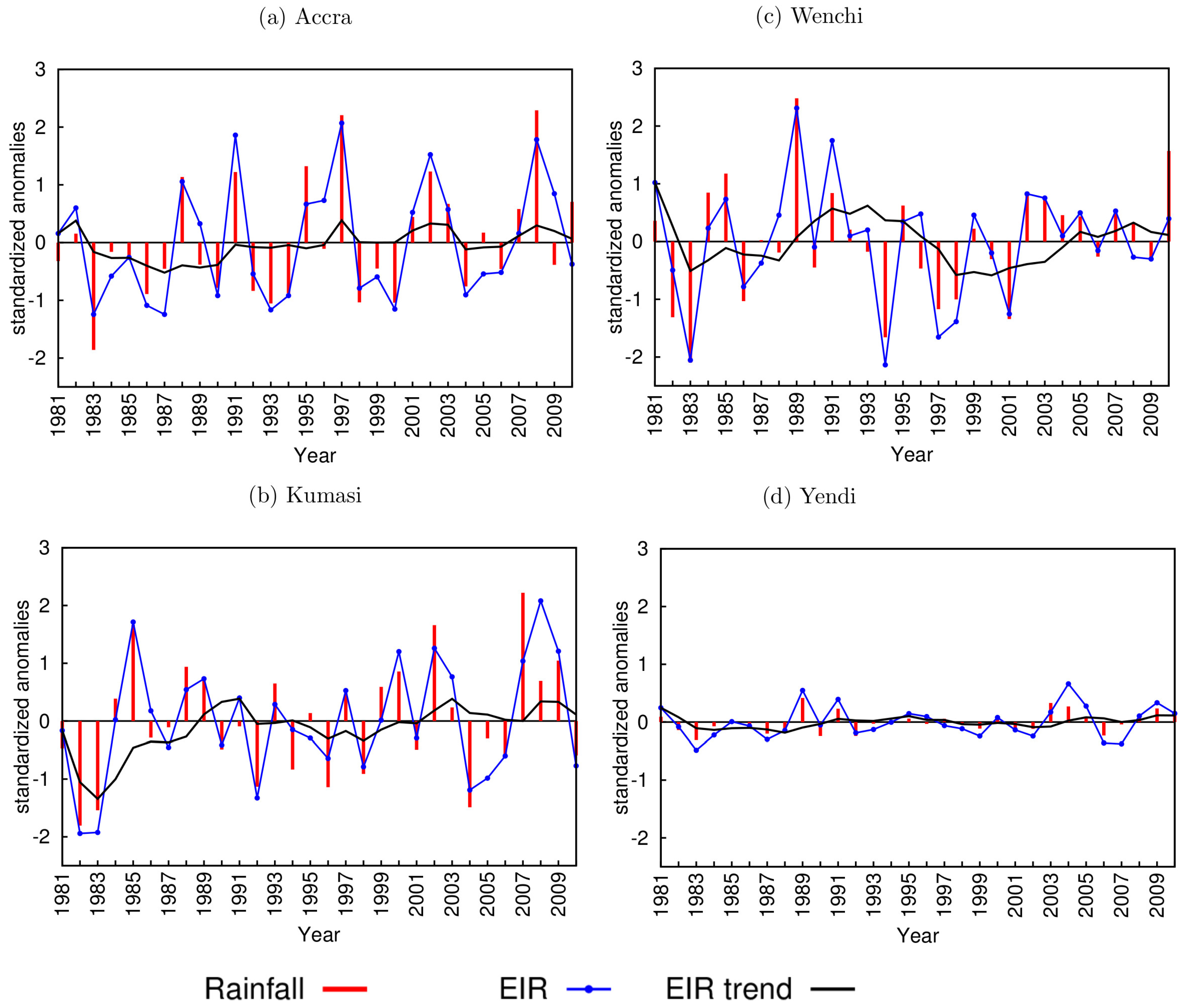
3. Results and Discussion

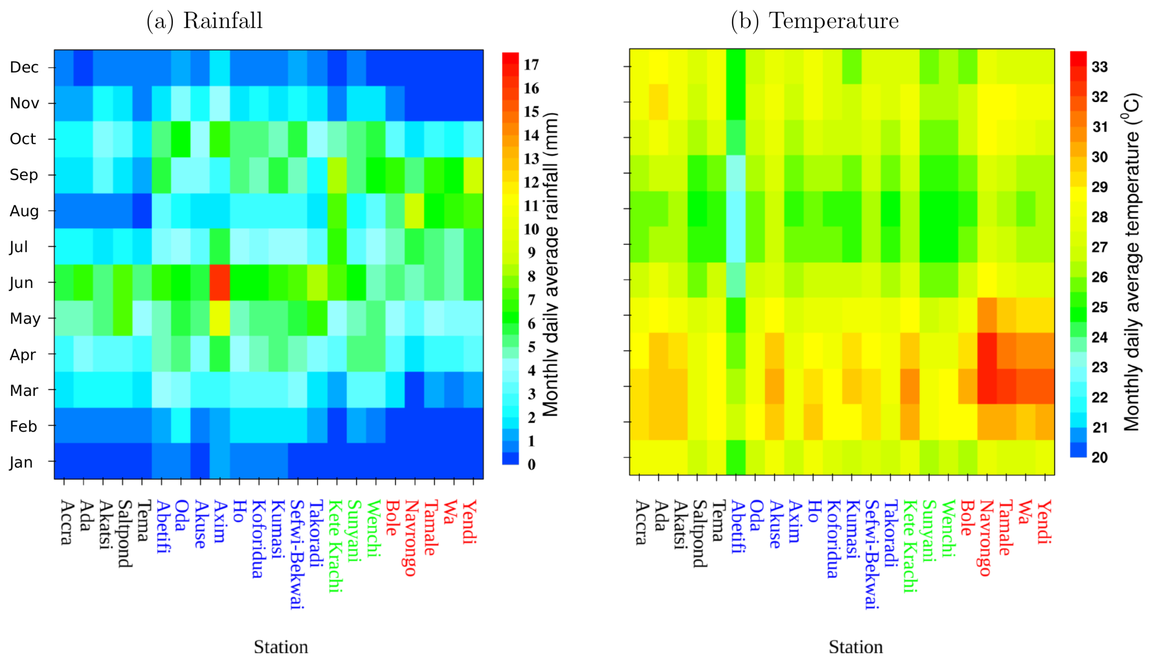
3.1. Rainfall and Temperature Variability
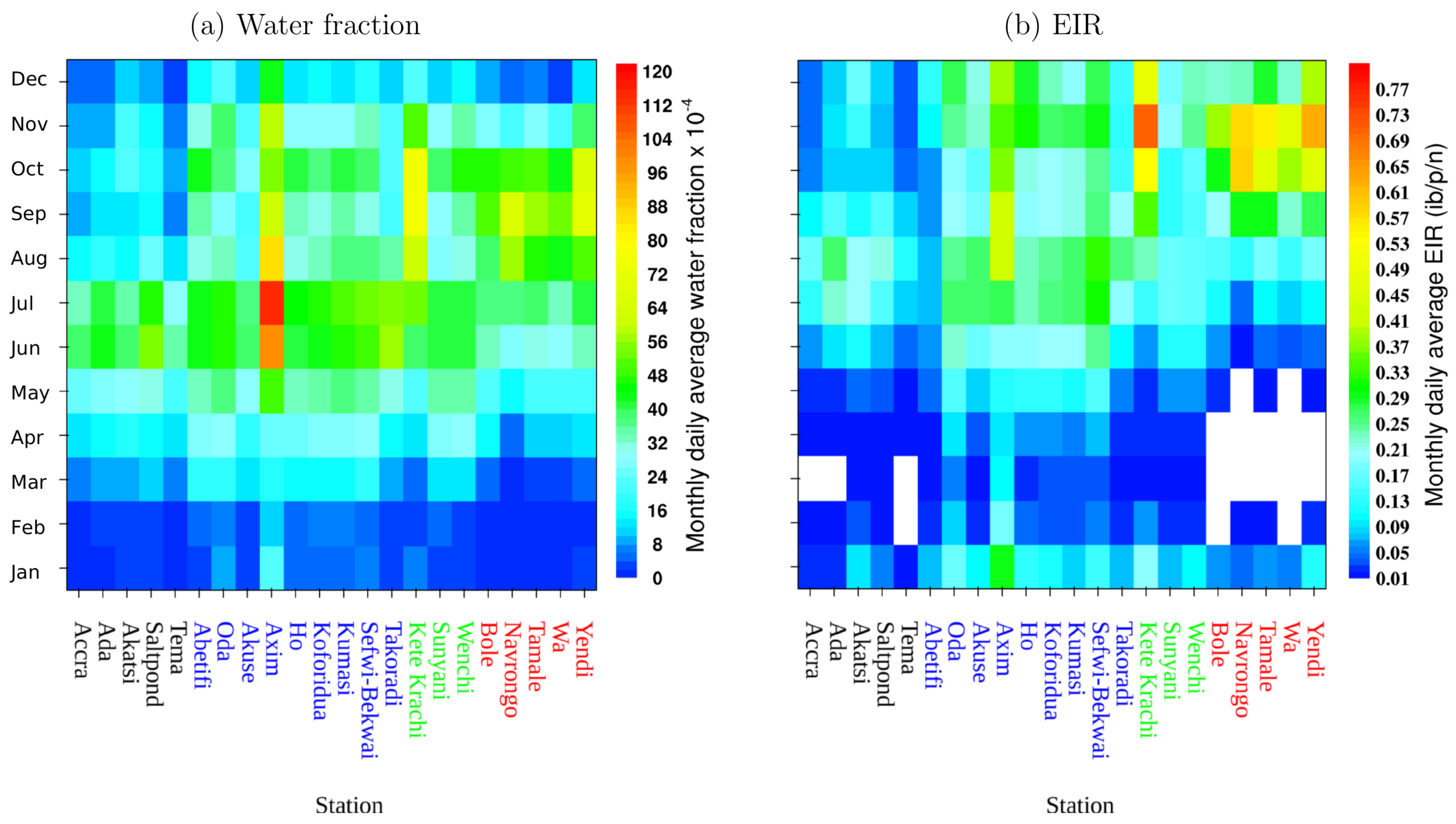
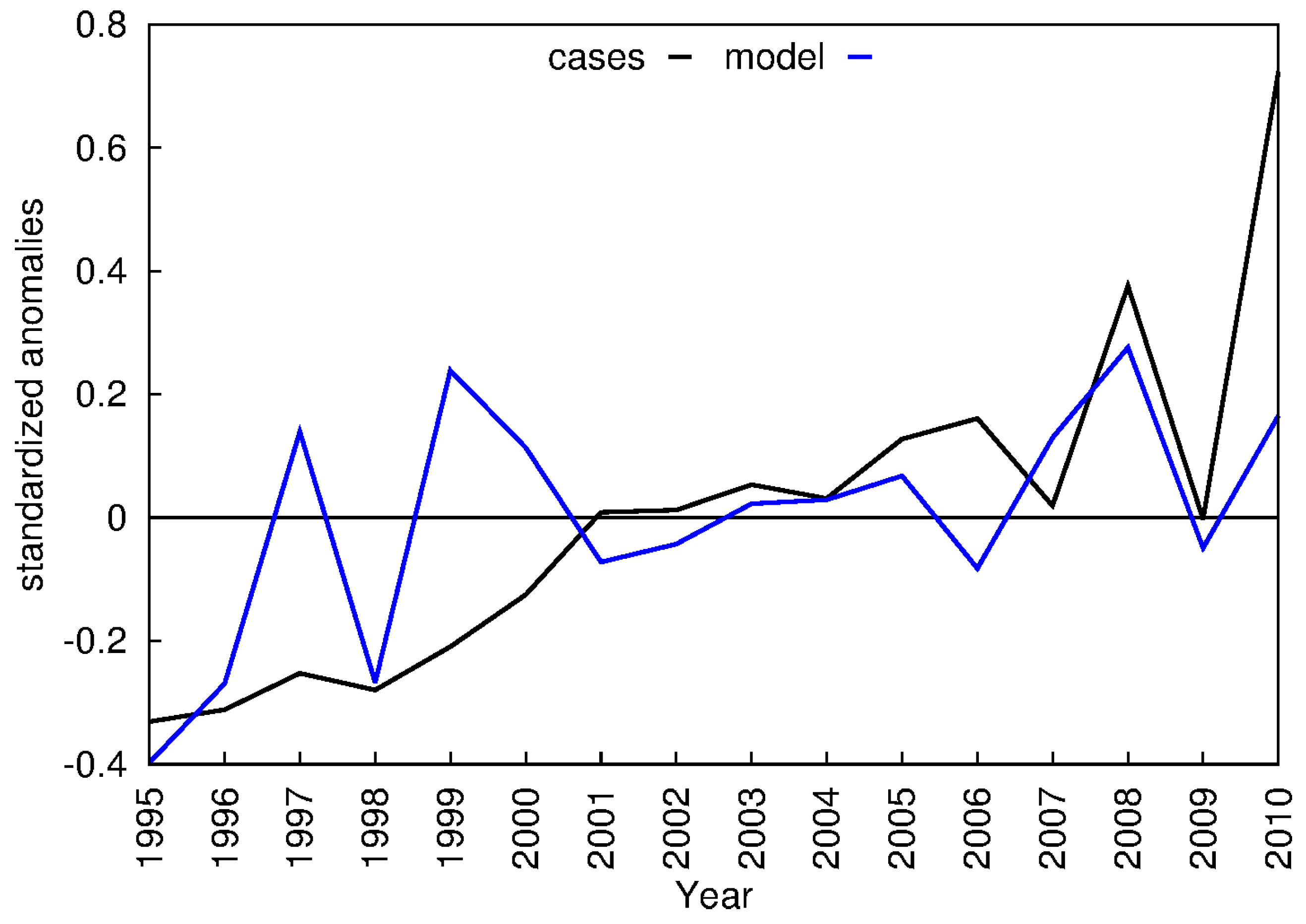
The temperature observations from various synoptic stations range from 22 C to 34 C, which are within the range that supports malaria transmission (Figure 2b). The high temperatures occur mostly between February and May, while low temperatures generally occur between June and October across all the various zones. The mean daily rain rates at the stations vary between 0 and 17 mm·day 1 (see Figure 2a). In the coastal agro-ecological zone, the major and minor rainfall peaks occurred in June and October, respectively. Similar peaks in major and minor seasons were observed over the forest agro-ecological zone with the exception of Abetifi, where the minor season peaked in September. In the transitional zone, the peaks occurred in June and September for Suyani and Kete-Krachi, respectively. However, early peaks in the major season occurred in April for Wenchi, but the minor season peak was in September. Over the savanna zone with a unimodal rainfall regime, rainfall peaked in September for Bole, Tamale and Yendi. However, rainfall onset was one month earlier at Navrongo and Wa. These variations in rainfall control spatial malaria patterns.

3.2. Model Results

Figure 3 shows VECTRI (using the V1.3.0 hydrology scheme) simulated water fraction and EIR. The results clearly show that malaria transmission generally follows rainfall patterns. The timing of peaks in the simulated EIR follows peaks in rainfall but with a lag time of approximately two months (see Figure 2b and Figure 3b). A similar lag between rainfall and EIR have been observed in the country [21]. In the savanna zone with unimodal rainfall, the model simulated a single peak in malaria transmission, while the remaining zones with bimodal rainfall regimes simulated malaria intensity that exhibit two peaks. In the VECTRI model, malaria transmission is sustained if simulated EIR 0 . 01 [33]. Based on this, length of transmission is between 10 and 12 months for the coastal zone, all year transmission in the forest and transition zones and between 8 and 10 months in the savanna zone. To some extent, these results are within the range reported from field observations [46]. However, it is likely that transmission within these zones may be different from the model results due to some effects not accounted for in the VECTRI model. One such difference is permanent water bodies that can sustain transmission during the dry season.
The VECTRI simulated transmission intensity (Figure 3b) also agrees with observation studies. Appawu et al. [10] found the highest transmission between June and October for Kassena Nankana district with Navrongo as its capital. In the same district, Kasasa et al. [13] observed mosquito bites in September and Koram et al. [47] found lowest and highest transmission in May and November, respectively. The model showed a similar pattern, but the range was between July and November for Navrongo. In Accra, using hospital data, Donovan et al. [21] identified peaks in malaria either in July or August, which is consistent with EIR peak in August followed by July simulated by the model for Accra. In Kintampo in the transition zone, Dery et al. [20] found the peak month to be September followed by November. This is to some extent in agreement with VECTRI simulated EIR for the three stations located in this zone, which all peaked in November. This level of agreement between VECTRI predicted peak month and that from field observation studies point to the fact that VECTRI can provide valuable early warning information for malaria control.
In addition to predicting the malaria peak months across the four agro-ecological zones, the VECTRI model was able to predict EIR values that tend to agree with observation based studies (Figure 3b). For instance, in Accra in the coastal zone, Klinkenberg et al. [22] found EIR values of 6.6 and 19.2 infective bites/person/year (ib/p/y) (which translates to 0.018 and 0.052 infective bites/person/night (ib/p/n), respectively, for areas located near to and far from agricultural sites. These were consistent with model values for Accra ranging between 0.014 and 0.173 with average of 0.062 ib/p/n. Similarly, the model predicted EIR values (see Figure 3b) are in good agreement with the range (0.1 and 0.7 ib/p/n) estimated by Dadzie et al. [14] from mosquitoes captured by human landing method at some locations within the country. In addition, the mean annual EIR value of 0.02 ib/p/n reported by Robert et al. [41] for urban city centers across sub-Saharan Africa is within the range of simulated EIR values. However, in Navrongo, monthly VECTRI predicted EIR values (0 to 0.587 ib/p/n) were lower but comparable to the range observed by Kasasa et al. [13] (0 to 1.06 ib/p/n). Furthermore, at Kintampo in the transition zone, Owusu-Agyei et al. [25] measured EIR that varies between 0.18 and 0.55 ib/p/n, which is within the range (0.023–0.702) of values from VECTRI for simulations for the three stations in this zone. These slight differences between the VECTRI simulated and reported EIR values from field studies may be due to the fact that the VECTRI results are based on 30-year climatology simulations, while the field studies range from a year to about five years. Despite this, VECTRI demonstrates its ability to simulate malaria patterns across the different agro-ecological zones in Ghana.
Another feature of this study is the ability of the VECTRI model to combine both rainfall and temperature effects in determining malaria transmission dynamics. While maximum rainfall and simulated water fraction were recorded at Axim (Figure 2b and Figure 3a), the maximum simulated EIR (Figure 3b) occurred at Kete-Krachi. A combination of factors may have resulted in this observation. Firstly, the high rainfall at Axim is likely to increase overflow from the ponds, which, in effect, will reduce the productivity of the mosquito developmental habitats [42,48]. Secondly, the low temperatures recorded at Axim (mean = 26.76 C; range between 25.02 and 28.10 C) relative to Kete-Krachi (mean = 28.08 C; range between 26.17 and 30.76 C) may have contributed as the optimum temperature for malaria transmission ranges between 28 and 32 C [49,50]. This confirms that the VECTRI model is able to account for the non-linear relationship between rainfall and level of malaria incidence.
It should be emphasized that the VECTRI model was also able to account for the significant impact of temperature in malaria transmission dynamics. For instance, despite Abetifi (601 m elevation) and Oda (132 m elevation) stations being located about 128 km apart and having almost similar rainfall patterns (Figure 4a), the VECTRI simulated EIR shows consistently lower values at Abetifi relative to Oda (Figure 4c). This observation is significantly due to the lower temperatures recorded at Abetifi (mean = 24.68 C; range between 22.78 and 26.50 C) as a result of its higher altitude relative to Oda (mean = 27.05 C; range between 25.51 and 28.51 C) (Figure 4b). This result clearly shows the model’s ability to resolve the important temperature-dependent development rate for both the vector and the parasite. In addition, the model simulated mean lower EIR value of 0.063 ib/p/n (range between 0.012 and 0.137) for Abetifi is close to the value of 0.041 ib/p/n reported by Owusu et al. [51] in Kwahu-Mpraeso about 10 km from Abetifi. This clearly shows that malaria is still prevalent in the high altitude areas in Ghana although transmission levels are low. Areas such as Abetifi are likely to experience malaria epidemics during years with anomalously warm temperature as rainfall is not limiting transmission and stands to gain a lot from advance prediction of malaria incidence that the VECTRI model is capable of providing.

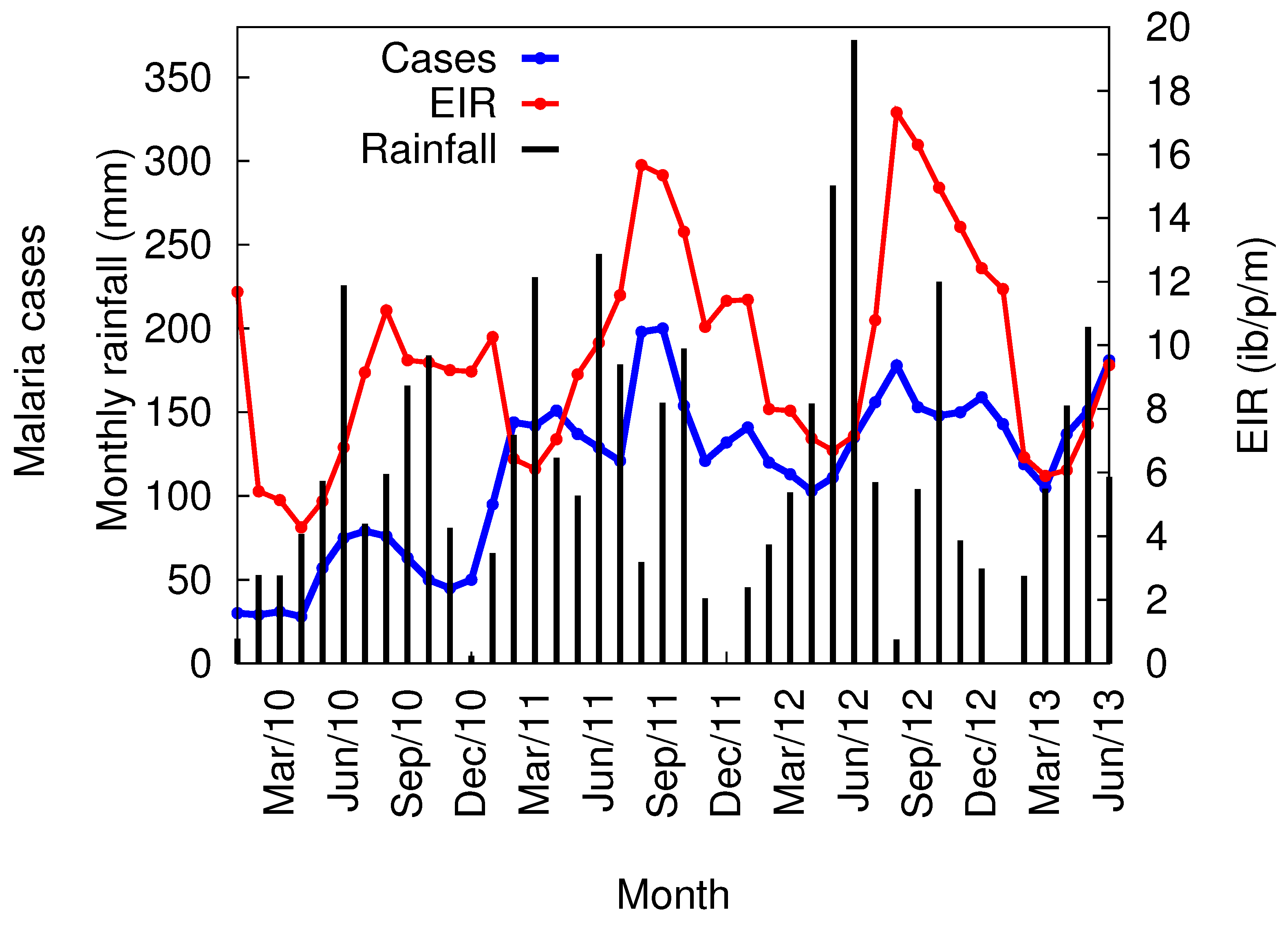
3.3. VECTRI Simulated EIR and Annual Malaria Cases

Figure 5 shows anomalies in rainfall and simulated EIR for some selected stations in each of the zones. Generally, EIR closely follows the trend in rainfall across all the zones but exhibits interannual variability. This is due to the fact that the mean temperature over the whole country is above the threshold of 16 C that supports malaria transmission. It is notable that the VECTRI simulations reveal a slight upward trend from 2003 (Figure 5), which can be attributed to rainfall increase. However, care must be taken in the interpretation of these results as critical non climatic factors were not accounted for and the model was integrated with the same population density. There is a possibility that the actual transmission patterns may differ from what is presented in Figure 5. For instance, for Yendi (Figure 5d), low EIR was predicted due to the unimodal rainfall regime with a prolonged dry season. However, actual EIR is likely to be higher if there is presence of permanent water bodies in the area, which could serve as potential breeding grounds during the dry season to sustain malaria transmission. Despite this, the simulated EIRs are within the range reported from field based studies, which point to the critical importance of rainfall in controlling spatial and temporal distribution of malaria in the country. This study serves as a baseline for future studies looking at the role of both climatic and non-climatic factors in controlling malaria transmission intensity in Ghana.
The average annual malaria cases from various public health facilities and average VECTRI simulated EIR over the 22 synoptic stations between 1995 and 2010 are compared (Figure 6). Despite the disparities in trend between EIR simulations and reported malaria cases for the first seven years (up to 2001), there is a relatively good similarity between the two time series afterwards. The correlation of determination value of R 2 = 0 . 53 was observed between EIR and observed cases. It is important to note that this comparison was based on malaria case data from only public hospitals against VECTRI simulations from only 22 synoptic weather stations, and, therefore, interpretation should be done cautiously. It can be seen also from Figure 6 that there is an increase in both malaria cases and simulated EIR towards the end of the study period despite increase in intervention programs in recent times. It is worth mentioning that Ghana introduced the NHIS in 2003, which may have led to an increase in the number of people attending public health facilities for treatment, thereby increasing the number of reported malaria cases during the last periods of the study. However, this effect was not accounted for in the model, but the simulated EIR was also high during this period. This shows that there is the need to evaluate the potential of ongoing malaria control interventions in the country. The possibility of using VECTRI to address this challenge is the focus of future work.

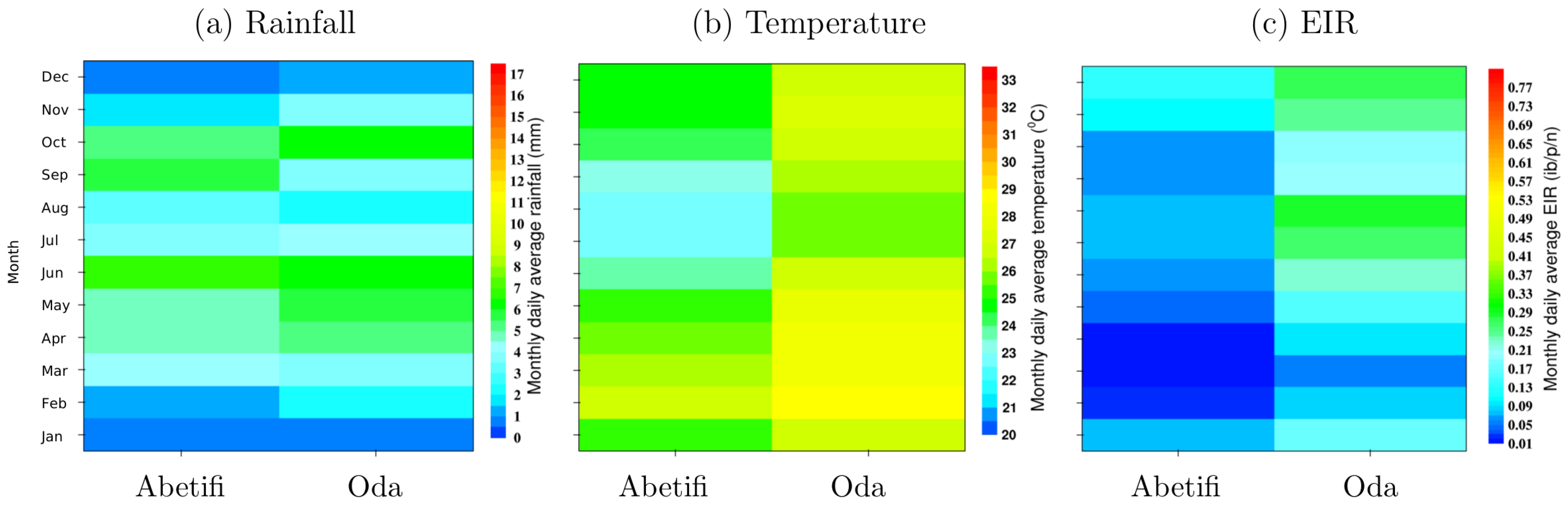
3.4. Local Scale Malaria Transmission

The output from a single station VECTRI run is compared to the Emena monthly recorded confirmed malaria cases (Figure 7). Reported cases from the hospital indicates transmission that is slightly stable and exhibits relatively small intraannual variability. On average, there is time lag of about two months between the peaks of rainfall (June) and malaria incidence (August).
The VECTRI using the new surface hydrology scheme reproduces a realistic trend in the reported cases with correlation of determination ( R 2 = 0 . 54 ). Interestingly, this correlation value is higher than the best ( R 2 = 0.32) obtained using rainfall directly. This value was obtained at a two-month time lag. A similar relatively small correlation ( R 2 = 0.29 at a two-month lag time) between rainfall and monthly malaria cases was observed by Tay et al. [27] at this same study location. In addition, the simulated EIR (see Figure 7) tends to agree with the range 7.8 and 15 infective bites/person/month ( i b / p / m ) for the same study location (Emena) published by Wihibeturo [52] from field based studies. This further confirms the potential of the VECTRI model to simulate local scale malaria transmission dynamics despite being a regional model [44]. Nevertheless, VECTRI performance could be improved by including non-climatic factors.

4. Conclusions

In this study, we explored the potential of a regional scale dynamical model VECTRI to simulate climate driven spatio-temporal malaria transmission dynamics over the four agro-ecological zones in Ghana. The simulated results reveal intra- and inter-agro-ecological variability in terms of intensity and duration of malaria transmission that are predominantly controlled by rainfall. However, temperature was found to suppress transmission only at Abetifi, a town located on the Kwahu plateau. The correlation between annual model predicted malaria incidence (EIR) and national recorded malaria cases from public health facilities was more than 0.5. On a local scale evaluation, the correlation between monthly predicted and hospital recorded malaria cases was greater than 0.5. Interestingly, this correlation was higher than the best obtained between rainfall and malaria cases. This indicates that the VECTRI model has superior predictive ability relative to using rainfall directly.
These results demonstrate useful application of the VECTRI model to simulate malaria transmission dynamics at both national and local scales. Consequently, the VECTRI model possesses the potential to provide malaria early warning information for Ghana and should be considered by the NMCP. In addition, the model was able to discriminate between areas of low and high malaria transmission due to difference in temperature regimes and could therefore be a useful tool to study the disease patterns under future climate change. Nevertheless, improved VECTRI model performance could likely be achieved by including parametrization for permanent water bodies, topography, soil characteristics, habitat water temperature, immunity level of the population and mosquito infection status.

Acknowledgments

Ernest O. Asare was generously funded by two International Centre of Theoretical Physics (ICTP) programmes, namely the Italian government’s funds-in-trust programme and the ICTP PhD Sandwich Training and Educational Programme (STEP). The study was funded by two European Union’s Seventh Framework Programmes: HEALTHY FUTURES under the Grant No. 266327 and QWeCI (Quantifying Weather and Climate Impacts on health in developing countries) under Grant No. 243964.

Author Contributions

Ernest O. Asare conceived, designed and performed the experiments. Ernest O. Asare analyzed the data and wrote the manuscript. Leonard K. Amekudzi proofread the manuscript including scientific discussions.

Conflicts of Interest

The authors declare no conflict of interest.

Abbreviations

The following abbreviations are used in this manuscript:
VECTRIvector-borne disease community model of the International Centre for Theoretical Physics, Trieste
GMetGhana Meteorological Agency
EIRentomological inoculation rate
HYDREMATShydrology, entomology, and malaria transmission simulator model
ib/p/yinfective bites/person/year
ib/p/ninfective bites/person/night

References

  1. Adams, I.; Darko, D.; Accorsi, S. Malaria: A burden explored. Bull. Health Inf. 2004, 1, 28–34. [Google Scholar]
  2. National Malaria Control Programme (NMCP). Annual Report; National Malaria Control Programme (NMCP), Ministry of Health: Accra, Ghana, 2008.
  3. Ghana Health Service (GHS). Annual Report; National Malaria Control Programme (NMCP), Ministry of Health: Accra, Ghana, 2011.
  4. Asante, F.A.; Asenso-Okyere, K. Economic Burden of Malaria in Ghana; World Health Organ (WHO): Geneva, Switzerland, 2003; pp. 1–83. [Google Scholar]
  5. Sicuri, E.; Vieta, A.; Lindner, L.; Constenla, D.; Sauboin, C. The economic costs of malaria in children in three sub-Saharan countries: Ghana, Tanzania and Kenya. Malar. J. 2013, 12, 307. [Google Scholar] [CrossRef] [PubMed]
  6. Ghana Health Service (GHS). Strategic Plan for Malaria Control in Ghana 2008–2015; National Malaria Control Programme (NMCP), Ministry of Health: Accra, Ghana, 2009.
  7. Dontwi, I.; Dedu, V.; Aboagye, N. Ascertaining the Financial Cost of Malaria and Mitigating against It Using Actuarial Models for Financial Cost. Int. J. Financ. Res. 2013, 4, 94. [Google Scholar] [CrossRef]
  8. Akazili, J.; Aikins, M.; Binka, F.N. Malaria treatment in Northern Ghana: What is the treatment cost per case to households? Afr. J. Health Sci. 2008, 14, 70–79. [Google Scholar] [CrossRef]
  9. Appawu, M.; Baffoe-Wilmot, A.; Afari, E.; Nkrumah, F.; Petrarca, V. Species composition and inversion polymorphism of the Anopheles gambiae complex in some sites of Ghana, west Africa. Acta Trop. 1994, 56, 15–23. [Google Scholar] [CrossRef]
  10. Appawu, M.; Owusu-Agyei, S.; Dadzie, S.; Asoala, V.; Anto, F.; Koram, K.; Rogers, W.; Nkrumah, F.; Hoffman, S.L.; Fryauff, D.J. Malaria transmission dynamics at a site in northern Ghana proposed for testing malaria vaccines. Trop. Med. Int. Health 2004, 9, 164–170. [Google Scholar] [CrossRef] [PubMed]
  11. Yawson, A.; McCall, P.; Wilson, M.; Donnelly, M. Species abundance and insecticide resistance of Anopheles gambiae in selected areas of Ghana and Burkina Faso. Med. Vet. Entomol. 2004, 18, 372–377. [Google Scholar] [CrossRef] [PubMed]
  12. De Souza, D.; Kelly-Hope, L.; Lawson, B.; Wilson, M.; Boakye, D. Environmental factors associated with the distribution of Anopheles gambiae ss in Ghana; an important vector of lymphatic filariasis and malaria. PLoS ONE 2010, 5, e9927. [Google Scholar] [CrossRef] [PubMed]
  13. Kasasa, S.; Asoala, V.; Gosoniu, L.; Anto, F.; Adjuik, M.; Tindana, C.; Smith, T.; Owusu-Agyei, S.; Vounatsou, P. Spatio-temporal malaria transmission patterns in Navrongo demographic surveillance site, northern Ghana. Malar. J. 2013, 12, 63. [Google Scholar] [CrossRef] [PubMed] [Green Version]
  14. Dadzie, S.K.; Brenyah, R.; Appawu, M.A. Role of species composition in malaria transmission by the Anopheles funestus group (Diptera: Culicidae) in Ghana. J. Vector Ecol. 2013, 38, 105–110. [Google Scholar] [CrossRef] [PubMed]
  15. Afari, E.; Appawu, M.; Dunyo, S.; Baffoe-Wilmot, A.; Nkrumah, F. Malaria infection, morbidity and transmission in two ecological zones Southern Ghana. Afr. J. Health Sci. 1995, 2, 312–315. [Google Scholar] [PubMed]
  16. Klinkenberg, E.; McCall, P.; Hastings, I.; Wilson, M.; Amerasinghe, F.; Donnelly, M. Malaria and irrigated crops, Accra, Ghana. Emerg. Infect. Dis. 2005, 11, 1290. [Google Scholar] [CrossRef] [PubMed]
  17. Koram, K.; Owusu-Agyei, S.; Fryauff, D.; Anto, F.; Atuguba, F.; Hodgson, A.; Hoffman, S.; Nkrumah, F. Seasonal profiles of malaria infection, anaemia, and bednet use among age groups and communities in northern Ghana. Trop. Med. Int. Health 2003, 8, 793–802. [Google Scholar] [CrossRef] [PubMed]
  18. Dinko, B.; Oguike, M.C.; Larbi, J.A.; Bousema, T.; Sutherland, C.J. Persistent detection of Plasmodium falciparum, P. malariae, P. ovale curtisi and P. ovale wallikeri after ACT treatment of asymptomatic Ghanaian school-children. Int. J. Parasitol. Drugs Drug Resist. 2013, 3, 45–50. [Google Scholar] [CrossRef] [PubMed] [Green Version]
  19. Afari, E.; Akanmori, B.; Nakano, T.; Ofori-Adjei, D. Plasmodium falciparum: Sensitivity to chloroquine in vivo in three ecological zones in Ghana. Trans. R. Soc. Trop. Med. Hyg. 1992, 86, 231–232. [Google Scholar] [CrossRef]
  20. Dery, D.B.; Brown, C.; Asante, K.P.; Adams, M.; Dosoo, D.; Amenga-Etego, S.; Wilson, M.; Chandramohan, D.; Greenwood, B.; Owusu-Agyei, S. Patterns and seasonality of malaria transmission in the forest-savannah transitional zones of Ghana. Malar. J. 2010, 9, 1–8. [Google Scholar] [CrossRef] [PubMed]
  21. Donovan, C.; Siadat, B.; Frimpong, J. Seasonal and socio-economic variations in clinical and self-reported malaria in Accra, Ghana: Evidence from facility data and a community survey. Ghana Med. J. 2012, 46, 85–94. [Google Scholar] [PubMed]
  22. Klinkenberg, E.; McCall, P.; Wilson, M.; Amerasinghe, F.; Donnelly, M. Impact of urban agriculture on malaria vectors in Accra, Ghana. Malar. J. 2008, 7, 151. [Google Scholar] [CrossRef] [PubMed]
  23. Okoye, P.; Wilson, M.; Boakye, D.; Brown, C. Impact of the Okyereko irrigation project in Ghana on the risk of human malaria infection by Anopheles species (Diptera: Culicidae). Afr. Entomol. 2005, 13, 249. [Google Scholar]
  24. Akpalu, W.; Codjoe, S.N.A. Economic analysis of climate variability impact on malaria prevalence: The case of Ghana. Sustainability 2013, 5, 4362–4378. [Google Scholar] [CrossRef]
  25. Owusu-Agyei, S.; Asante, K.; Adjuik, M.; Adjei, G.; Awini, E.; Adams, M.; Newton, S.; Dosoo, D.; Dery, D.; Agyeman-Budu, A.; et al. Epidemiology of malaria in the forest-savanna transitional zone of Ghana. Malar. J. 2009, 8, 220. [Google Scholar] [CrossRef] [PubMed]
  26. Baird, J.K.; Agyei, S.O.; Utz, G.C.; Koram, K.; Barcus, M.J.; Jones, T.R.; Fryauff, D.J.; Binka, F.N.; Hoffman, S.L.; Nkrumah, F.N. Seasonal malaria attack rates in infants and young children in northern Ghana. Am. J. Trop. Med. Hyg. 2002, 66, 280–286. [Google Scholar] [PubMed]
  27. Tay, S.; Danuor, S.; Mensah, D.; Acheampong, G.; Abruquah, H.; Morse, A.; Caminade, C.; Badu, K.; Tompkins, A.; Hassan, H. Climate Variability and Malaria Incidence in Peri-urban, Urban and Rural Communities Around Kumasi, Ghana: A Case Study at Three Health Facilities; Emena, Atonsu and Akropong. Int. J. Parasitol. Res. 2012, 4, 83. [Google Scholar]
  28. Klutse, N.A.B.; Aboagye-Antwi, F.; Owusu, K.; Ntiamoa-Baidu, Y. Assessment of Patterns of Climate Variables and Malaria Cases in Two Ecological Zones of Ghana. Open J. Ecol. 2014, 4, 764. [Google Scholar] [CrossRef]
  29. Danuor, S.; Tay, S.; Annor, T.; Forkuo, E.; Bosompem, K.; Antwi, V. The impact of climate variability on malaria incidence and prevalence in the forest zone of Ghana–A case study at two (2) hospitals located within the Kumasi Metropolitan area of the Ashanti Region of Ghana. In Proceedings of the 2nd International Conference: Climate, Sustainability and Development in Semi-Arid Regions, Fortaleza, Brazil, 16–20 August 2010; pp. 16–20.
  30. Krefis, A.; Schwarz, N.; Krüger, A.; Fobil, J.; Nkrumah, B.; Acquah, S.; Loag, W.; Sarpong, N.; Adu-Sarkodie, Y.; Ranft, U.; et al. Modeling the Relationship between Precipitation and Malaria Incidence in Children from a Holoendemic Area in Ghana. Am. J. Trop. Med. Hyg. 2011, 84, 285–291. [Google Scholar] [CrossRef] [PubMed]
  31. Kelly-Hope, L.; Hemingway, J.; McKenzie, F. Environmental factors associated with the malaria vectors Anopheles gambiae and Anopheles funestus in Kenya. Malar. J. 2009, 8, 268. [Google Scholar] [CrossRef] [PubMed]
  32. Lowe, R.; Chirombo, J.; Tompkins, A.M. Relative importance of climatic, geographic and socio-economic determinants of malaria in Malawi. Malar. J. 2013, 12, 416. [Google Scholar] [CrossRef] [PubMed]
  33. Tompkins, A.M.; Ermert, V. A regional-scale, high resolution dynamical malaria model that accounts for population density, climate and surface hydrology. Malar. J. 2013, 12, 65. [Google Scholar] [CrossRef] [PubMed]
  34. Smith, M.; Macklin, M.G.; Thomas, C.J. Hydrological and geomorphological controls of malaria transmission. Earth-Sci. Rev. 2013, 116, 109–127. [Google Scholar] [CrossRef]
  35. Asare, E.O.; Tompkins, A.M.; Amekudzi, L.K.; Ermert, V. A breeding site model for regional, dynamical malaria simulations evaluated using in situ temporary ponds observations. Geospat. Health 2016, 11, 390. [Google Scholar] [CrossRef] [PubMed]
  36. Tompkins, A.M.; Di Giuseppe, F. Potential predictability of malaria in Africa using ECMWF monthly and seasonal climate forecasts. J. Appl. Meteorol. Climatol. 2015, 54, 521–540. [Google Scholar] [CrossRef]
  37. Owusu, K.; Waylen, P.R. The changing rainy season climatology of mid-Ghana. Theor. Appl. Climatol. 2013, 112, 419–430. [Google Scholar] [CrossRef]
  38. Manzanas, R.; Amekudzi, L.; Preko, K.; Herrera, S.; Gutiérrez, J.M. Precipitation variability and trends in Ghana: An intercomparison of observational and reanalysis products. Clim. Chang. 2014, 124, 805–819. [Google Scholar] [CrossRef]
  39. Amekudzi, L.K.; Yamba, E.I.; Preko, K.; Asare, E.O.; Aryee, J.; Baidu, M.; Codjoe, S.N. Variabilities in Rainfall Onset, Cessation and Length of Rainy Season for the Various Agro-Ecological Zones of Ghana. Climate 2015, 3, 416–434. [Google Scholar] [CrossRef]
  40. Ghana Ministry of Health. Facts and Figures. 2015. Available online: https://en.wikipedia.org/wiki/Main_Page (accessed on 3 December 2015).
  41. Robert, V.; Macintyre, K.; Keating, J.; Trape, J.; Duchemin, J.; Warren, M.; Beier, J. Malaria transmission in urban sub-Saharan Africa. Am. J. Trop. Med. Hyg. 2003, 68, 169–176. [Google Scholar] [PubMed]
  42. Paaijmans, K.; Wandago, M.; Githeko, A.; Takken, W. Unexpected high losses of Anopheles gambiae larvae due to rainfall. PLoS ONE 2007, 2, e1146. [Google Scholar] [CrossRef] [PubMed]
  43. United States Department of Agriculture (USDA). National Engineering Handbook, Section 4: Hydrology; United States Department of Agriculture: Washington, DC, USA, 1972.
  44. Asare, E.O.; Tompkins, A.M.; Bomblies, A. A Regional Model for Malaria Vector Developmental Habitats Evaluated Using Explicit, Pond-Resolving Surface Hydrology Simulations. PLoS ONE 2016, 11, e0150626. [Google Scholar] [CrossRef] [PubMed]
  45. Bomblies, A.; Duchemin, J.; Eltahir, E. Hydrology of malaria: Model development and application to a Sahelian village. Water Resour. Res. 2008, 44, W12445. [Google Scholar] [CrossRef]
  46. Ghana Statistical Service (GSS). Ghana Multiple Indicator Cluster Survey with an Enhanced Malaria Module and Biomarker; Final Report; Ghana Statistical Service: Accra, Ghana, 2011.
  47. Koram, K.A.; Owusu-Agyei, S.; Utz, G.; Binka, F.N.; Baird, J.K.; Hoffman, S.L.; Nkrumah, F.K. Severe anemia in young children after high and low malaria transmission seasons in the Kassena-Nankana district of northern Ghana. Am. J. Trop. Med. Hyg. 2000, 62, 670–674. [Google Scholar] [PubMed]
  48. Dieng, H.; Rahman, G.S.; Hassan, A.A.; Salmah, M.C.; Satho, T.; Miake, F.; Boots, M.; Sazaly, A. The effects of simulated rainfall on immature population dynamics of Aedes albopictus and female oviposition. Int. J. Biometeorol. 2012, 56, 113–120. [Google Scholar] [CrossRef] [PubMed]
  49. Paaijmans, K.; Read, A.; Thomas, M. Understanding the link between malaria risk and climate. Proc. Natl. Acad. Sci. USA 2009, 106, 13844–13849. [Google Scholar] [CrossRef] [PubMed]
  50. Craig, M.; Snow, R.; Le Sueur, D. A climate-based distribution model of malaria transmission in sub-Saharan Africa. Parasitol. Today 1999, 15, 105–111. [Google Scholar] [CrossRef]
  51. Owusu, E.D.; Buabeng, V.; Dadzie, S.; Brown, C.A.; Grobusch, M.P.; Mens, P. Characteristics of asymptomatic Plasmodium spp. parasitaemia in Kwahu-Mpraeso, a malaria endemic mountainous district in Ghana, West Africa. Malar. J. 2016, 15, 1. [Google Scholar] [CrossRef] [PubMed]
  52. Wihibeturo, B.A. Effect of Seasonal Variability on the Incidence and Transmission Patterns of Malaria in Urban, Peri-Urban and Rural Communities around Kumasi, Ghana. Master’s Thesis, Kwame Nkrumah University of Science and Technology, Kumasi, Ghana, 2014. [Google Scholar]
Figure 1. Map showing the 22 Ghana Meteorological Agency (GMet) synoptic stations grouped into the four agro-ecological zones. The Emena hospital and Agromet station are also shown.
Climate 05 00020 g001
Figure 2. The monthly daily average (a) rainfall and (b) temperature between 1981 and 2010 for the various GMet synoptic weather station. Different colors are used to represent different zones (black—coastal; blue—forest; green—transition; red—north).
Climate 05 00020 g002
Figure 3. The monthly daily average vector-borne disease community model of the International Centre for Theoretical Physics, Trieste (VECTRI) simulated (a) water fraction and (b) Entomological Inoculation Rate (EIR) over the 30-year climatology (1981 to 2010) for various GMet synoptic weather stations. The whites spaces indicate months where EIR was less than 0.01 (no malaria transmission).
Climate 05 00020 g003
Figure 4. Comparison of observed rainfall, temperature and VECTRI simulated EIR for Abetifi and Oda stations.
Climate 05 00020 g004
Figure 5. Anomalies of rainfall and simulated EIR for some selected synoptic stations in each of the agro-ecological zones.
Climate 05 00020 g005
Figure 6. Comparison of average VECTRI simulated EIR and annual malaria morbidity from public health facilities.
Climate 05 00020 g006
Figure 7. Comparison of monthly VECTRI simulated single location EIR and Emena hospital morbidity data.
Climate 05 00020 g007
Table 1. VECTRI (vector-borne disease community model of the International Centre for Theoretical Physics, Trieste) revised surface hydrology scheme (Equation (2)) default constants.
SymbolValueUnits
w m a x 0.1
w r e f 0.005
h r e f 250mm
p1.5
I m a x 250mm
E5mm
C N 90
CN is the curve number.

