Place-Making of Transit Towns in Qatar: The Case of Qatar National Museum-Souq Waqif Corridor


Department of Architecture and Urban Planning, Qatar University, Doha 3263, Qatar
*
Author to whom correspondence should be addressed.
Designs 2021, 5(1), 18; https://0-doi-org.brum.beds.ac.uk/10.3390/designs5010018
Submission received: 10 January 2021
/
Revised: 23 February 2021
/
Accepted: 1 March 2021
/
Published: 9 March 2021
(This article belongs to the Special Issue On Contemporary Architectural Design and the Rehabilitation of Built Heritage)
Abstract
:Over the last two decades, Doha, the capital city of Qatar, has undergone rapid urbanization. The city has capitalized large-scale urban and infrastructural projects resulting in a loss of historical areas of heritage value to people. Recent construction of the Doha Metro is opening avenues for place-making of transit towns through a framework envisioned by the need to shape compact, livable and sustainable neighborhoods and to mitigate the effects of urbanization on valuable historical heritage sites. Due to its historic significance, the Qatar National Museum (QNM)-Souq Waqif corridor is the case study selected for exploring and defining a framework for a contextualized place-making transit-oriented development (TOD) model. The research design is structured by reviewing the literature about TODs and the need for place-making model in Qatar, followed by collecting visual data from municipal authorities, through site visits, and site observations. The data are then analyzed to propose a novel masterplan, rooted in key urban design components of place-making. The insights will contribute to proposals for context-driven design strategies to enhance livability of the site and to extend its application to other potential transit hubs in metropolitan Doha and in the Middle East.
1. Introduction
Cities and towns around the world have been facing rapid urbanization leading to the construction of new settlements and infrastructural facilities. This has resulted in an extensive road network system covering the broader expanse of metropolitan built-up areas. In addition, vehicular dominance has heavily compromised other means of public transport such as pedestrian and bicycle networks. Despite extensive research on the physical, environmental and economic benefits of pedestrian-oriented and cycle-friendly networks, a large number of cities are neglecting the implementation of people-oriented transportation systems. This has given rise to lifeless urban areas, where the spatial form does not facilitate social interactions nor improve city-dwellers’ lifestyles.
In order to mitigate the negative impact of car dependency on the society, traffic congestion, urban sprawl and to encourage sustainable urban growth pattern, researchers have argued the need for planning smart and low-carbon eco-cities, planned through high-density, mixed land-use transit villages shaped around Metro stations, also defined as transit-oriented development (TOD) models. According to Dittmar and Ohland [1], TOD envisions walkable mixed-use development enclosing basic amenities located within a half mile distance of a transit hub, in order to allow pedestrians to have comfortable access to primary facilities and to reduce dependence on private vehicles.
The State of Qatar displays a heavily car-dependent built environment. Qatar’s opportunity to host the 2022 FIFA World Cup tournament led to initiating a nationwide investment strategy for the construction of new public transportation systems and infrastructure, port, stadiums and services facilities [2]. New transit projects such as the Metro Rail, comprising 4 lines connecting major hubs (37 stations), Lusail Light Rail Transit (LRT) and West Bay transit system were initiated to diversify public transit systems. In addition, since the mid-twentieth century’s surge in oil wealth, the State of Qatar has faced a unique rapid urbanization, under the influence of Westernized large-scale urban and architectural developments, lacking identity and place-making attributes. In turn, this has resulted in an initial negligence of historical heritage inner urban areas and the consequent urban regeneration of significant heritage districts such as Msheireb and Souq Waqif. Nevertheless, these renewed areas, and others of similar relevance, will face further urban growth challenges due to the integration of the existing urban fabric with Doha Metro rail. Such challenges might be related to the need to maintain a significant built heritage environment, conceived in order to enhance livability and the urban quality of life.
Even though there has been research on TOD in major hubs in Qatar, the urban regeneration of historic areas through a place-making TOD approach has not been investigated yet. The Qatar National Museum (QNM)-Souq Waqif corridor is one of the oldest areas of Doha, which recently witnessed the restoration and rehabilitation of its bustling marketplace, the Souq Waqif and the inauguration of the iconic Qatar National Museum. Despite these two landmarks being well recognized, immediate neighbourhoods connecting these areas have not been renewed. Therefore, the insights revealed from this investigation will help in proposing context-driven design strategies to enhance the livability of the investigated QNM-Souq Waqif corridor TODs and to apply it further in other potential transit hubs in metropolitan Doha and in the Middle East.
Considering the historical-heritage significance of the area spanning from QNM to the Souq Waqif marketplace (which will be referred to as the QNM-Souq Waqif corridor), this research studies the site’s spatial potential in being developed as a transit-oriented hub, where livability is enhanced by addressing and assessing context-based tools.
The research design is structured on reviewing the literature about TODs and the need for historical-heritage place-making models in Qatar, followed by collecting visual data through site visits, site observations and from municipal authorities. The data is then analyzed to propose a novel masterplan, rooted in historical heritage features of placemaking. The insights will contribute to proposing context-driven design strategies to enhance livability of the site and to extend its application to other potential transit hubs in metropolitan Doha and in the Middle East.
2. Literature Review
2.1. Transit-Oriented Development (TOD): A Place-Making Approach
The concept of TOD was defined by the American architect and urban planner Peter Calthorpe as a strategy to mitigate the impacts of urban sprawl. Broadly, his ideas were around the urban development of compact, mixed-use, mixed density settlements around transit stations [3,4,5]. The concept of TOD was conceived in the 1970s by the New Urbanist Movement, envisioned as a model to curb urban sprawl and placeless neighborhoods. TOD identifies a transport station, usually a rail or Metro around which planning develops to avail of mixed-use services within walking distance of the commuters. Since pedestrians are at the heart of TOD, the purpose of mixed uses is to encourage a pedestrian environment. TOD has seen the development of transit based on the application of the ‘3Ds’ key-principles: density, diversity and design. Later on, destination accessibility and distance to transit were included [6,7,8,9], along with a sixth ‘D’, or ‘travel demand management’ as a variable depending on vehicle trips [10,11,12].
Scholars classified TOD according to different combinations of the TOD principles. One of the attempts to study the choice of transit station was developed by Bertolini [13], known as the “node-place” approach, in which the suitability of a transit location was plotted on an “xy” scale, with “x” measuring the transit frequency and “y” measuring the place characteristics such as density, diversity and use. Further modifications to the node-place approach were developed by researchers over time by introducing aspects such as pedestrian shed and related design features [14,15,16,17].
Even though major contributors of transit ridership are found to be transit quality, station proximity and parking policies [18], effects of urban design characteristics on improving livability of a transit neighbourhood must not be overlooked. Earlier researchers focusing on understanding the reasons for living in a transit town argued that the quality of the urban fabric plays an important role towards housing choice and affordability [19,20]. Good urban design can generate secondary trips from an activity center by virtue of what can be regarded as the ‘resultant’ activities defined by Jan Gehl on public spaces [18,21,22]. Other measures like traffic calming and car-free streets can likely make walking safer, easier, and more enjoyable. Chatman’s research has reported a strong link between the quality of walkable environment and travel choice when it comes to optional activities such as non-work-related activities [23]. Walk/bike travel to non-work activities was found to increase by 7.1% for every 1000 retail workers within ½ mile radius of sampled residences [24]. Lund et al. [25] revealed that neighborhood-design variables such as street connectivity to the trip destination are a crucial contributor to transit ridership. These insights highlight that urban design features have a plausible effect on influencing user choice and thereby increasing transit ridership. Good design also contributes to the livability index of neighborhoods. To ensure its own future, public transit systems must become more connected to the communities they seek to serve [26].
The place-making approach aimed at injecting vibrancy in a neighborhood is also frequently mentioned in the TOD model. In design context, this refers to analyzing decisions on the urban fabric and travel behavior to enhance the ‘experience’ of place. Place-making can be broadly understood as improving the quality of urban design. Well-designed places also emphasize on the existing structures and elevate their experience either by architectural interventions or by addition of landscape elements [27]. By combining different building forms, such places mix uses and densities to “address problems associated with social exclusion and social capital by creating proximate opportunities for access to activities and social networks” [28]. By acting as a community focal point, transit stations with place-making attributes can alleviate problems of gentrification and selective access to higher echelons of society.
According to Dittmar and Ohland [1], place-making is where many first-generation TOD projects did not succeed in meeting their objectives. He argues that stations that attract development and create density needs, do not necessarily succeed in creating interesting places. Place-making can be achieved by analysing the neighbourhood’s urban character, adding amenities and improving it to attract visitors and users alike. Since walking is inevitable in transit with every trip beginning and ending with a walkable environment, it encourages a larger catchment area for transit users. One of the elements of place-making is to enliven streets by providing visual interest that encourages people to walk and to use transit. Similarly creating an active pedestrian environment (lining streets with people-oriented uses) is another aspect of the place-making characteristic. As experienced in many areas around the world, regional and historical architectural and landscape traditions close to transit corridors can contribute to successful place making. Improving conditions between streets and buildings, building entries and orientation, ground floor windows and building facades, design of off-street parking, outdoor wayfinding signage, alleys and streetscape design can contribute to place-making. While design is an integral part of place-making, other strategies such as maintenance and management of the public realm, establishing special events, and introducing cultural appropriation techniques can also play an important role in emphasizing the vitality and long-term sustenance of a place.
Theories and studies about TODs allowed us to review and understand the assessment tools or criteria to be addressed for shaping a livable and sustainable TOD. Firstly, many TODs have not been studied in the region; Dubai Metro was launched in 2009, but there are not many studies revealing how a TOD functions in the local context of Dubai. The Middle East does not share Western characteristics even though most urban planners practising in the Middle East are Western. This means that other factors must be addressed for a successful holistic place-making approach to TOD in Qatar in addition to the 6D’s mentioned earlier.
2.2. TODs in Qatar
Gulf cities have undergone tremendous urban transformation as a result of the export of oil and overall diversification of the economy. Qatar has changed from a pearling village to a global capital with highest per capita income over the last half of the previous century. Since the export of oil which began in December 1949, the country has witnessed a surge of large-scale urban and infrastructural projects. The beginning of the 21st century marked a rapid change of urbanscape in Qatar with the development of West Bay and other satellite cities such as Education City, Pearl Qatar, and Aspire Zone and so on [29,30,31]. After the post oil era of 1970, planning was decentralized, which led to a favorable synergy between developers and the planning agency [32,33,34].
Marking its beginning in Old Doha, Qatar developed new auto-dependent suburbs and peripheral areas connected via multiple ring roads. Due to flexible national policies on citizen welfare such as free plots, no-interest loans and free architectural and engineering services for Qatari construction [2,35,36], the private sector overtook the urban planning of Qatar, often outsourcing planning principles from Western planners. With rapid urbanism, Qatar experienced an increase in the development of peripheral low dense cities resulting in an urban sprawl compounded by the effects of a larger expanse of infrastructure and longer driving routes. In addition, the government invested large funds in developing newer districts outside old Doha. As a result, while diversity and density were implemented in newly developed Capital Business Districts such as West Bay, the inner city cores were neglected. Housing complexes were also developed in central areas, which was not preferred by the Qataris, who chose to reside in large villas in the outskirts of Doha, increasing the reliance on private vehicles.
Since the 1970s, large areas of the inner city have been razed to make way for new developments in vast compounds, comprising homogeneous standardized expressionless buildings. This was facilitated by ambitious construction schemes aided by oil revenue and newer building materials such as cement. Before the 1970s, inner core developments, dense urban forms and design characteristics prevalent in present day Souq Waqif such as shaded alleyways (sikkas), walkable fereej and a people-oriented cultural way of life was common in Old Doha. However, such residential areas were razed, for instance, in paving Grand Hamad Street to Corniche Street. Until heritage protection grew in prominence in the 1980s, the construction sector copied largely from the west. Often, national master planning has reflected Western ideals, resulting in cultural displacement and a disregard for vernacular urban form, rooted on car-based urbanism and functional distribution of land use rather than on cultural context [37]. Even after the initiation of conservation laws in 1980, large scale redevelopment projects in West Bay and other reclaimed land took prominence, pushing the historic urban core into a state of neglect and disrepair.
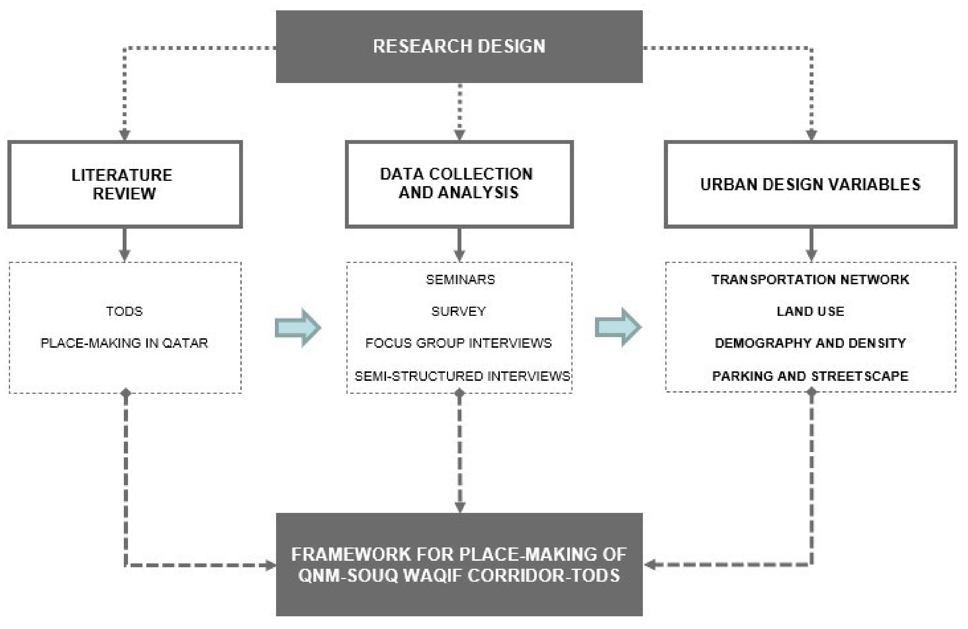
3. Research Design
The objective of this research study is (i) to assess the regenerative and transformative potential of the QNM-Souq Waqif Corridor-TODs and (ii) to provide an applicable sustainable-TOD model, enhancing city-dwellers’ livability. The research design is structured in 3 stages [38,39].
3.1. Reviewing the Literature: TOD Assessment Indices
The review of the literature contributed (i) to gathering information about significant planning concepts, such as TOD and historic/cultural heritage in an international and regional context; (ii) to initiate the exploration of the QNM-Souq Waqif corridor transit villages, and to understand and define TOD assessment indices for assessing the performance of a potential compact public-transport oriented node.
3.2. Data Collection and Analysis
As urban design is an interdisciplinary and multi-faceted field of study requiring a participatory approach in design through the active involvement of end-users, stakeholders and practitioners, the attendance of seminars delivered by Mr. Mohammed Ali Abdulla, the designer of the Souq Waqif, as well as a series of seminars conducted for the Souq Waqif nomination to the Aga Khan Awards for Architecture, provided a first-hand account of the detailed information on the aspirations and challenges of the regeneration project, as well as a visual documentation, historical/cartographic maps, architectural drawings and photographs of the historical site.
Through a survey addressed in January 2019 to 80 professionals from various governmental agencies operating directly with TOD [Ministry of Municipality and Environment (MME), Qatar Rail (QR), Qatar Museums Authority (QMA) and Ashghal Public Works Authority], the four categories of (i) Transportation network, (ii) Land Use, (iii) Demography and Density, (iv) Parking and Streetscape, were indicated as the most appropriate for assessing the performance of the selected QNM-Souq Waqif Corridor-TODs.
Subsequently, between February and June 2019 focus-group interviews were arranged with 40 participants from the selected governmental agencies. Participants were required to complete via email an anonymous questionnaire in order to highlight the relative importance of each aspect of success for the selected QNM-Souq Waqif corridor-TODs [as per four pre-identified categories]. Also, 40 end-users/citizens/respondents residing in the area were interviewed and asked to discuss and rate the selected indices and whether further relevant indicators had to be listed in the questionnaire. In addition, the methodology of the exploratory research utilizes inductive and deductive methods, gained through participatory observations, direct impressionistic observations, field study and on-site analysis, for the collection of visual data.
3.3. Findings: Propose a Novel Master Plan
Research by design is a common methodology in urbanism applied through two steps: (i) territorial analysis of the investigated area and (ii) generation of a framework as a way to produce concrete ideas of the investigated areas’ metamorphosis, through specific design tools. Particular emphasis is given to the interplay between territorial analysis and design exploration (Proposal for a Masterplan). The resulting place-making approach for planning QNM-Souq Waqif Corridor-TODs summarizes a framework enhancing the dependency between mapping and design. Site analysis through the four pre-identified categories allows to monitor and assessing the potential benefits of the investigated QNM-Souq Waqif corridor-TODs (Figure 1).
3.4. Case Study Context: Qatar National Museum (QNM)-Souq Waqif Corridor TODs
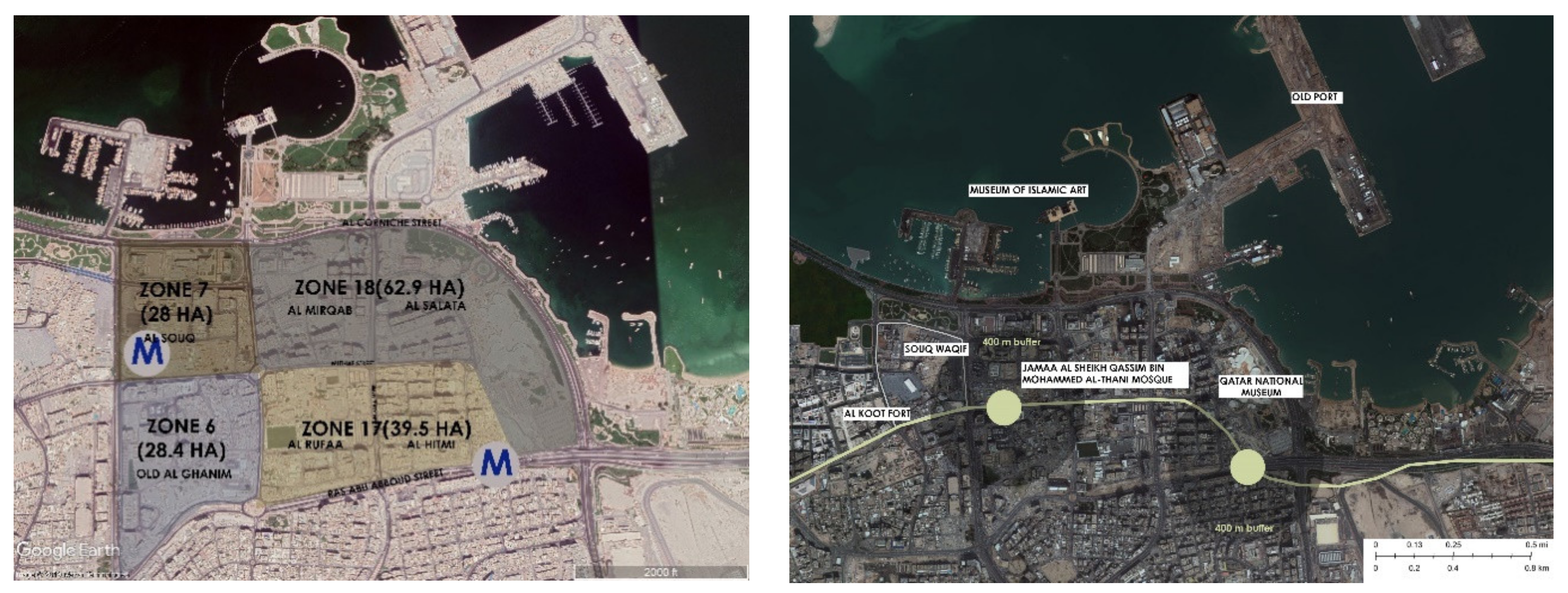
The study area covers the districts of Al Salata, Al Hitmi, Al Rufaa, Al Mirqab, Old Al Ghanim and Al Souq, including zones 18, 17, 7 and 6, respectively. Two key Metro stations, Qatar National Museum station and Souq Waqif Metro stations fall within the site context (Figure 2). The study area is flanked by Qatar National Museum premises to its east, Corniche Street on the North and Ras Abu Abboud expressway in the South. Corniche Street, being the active transport corridor linking the Central Business District of West Bay with old Doha and further to Hamad International Airport, forms one of the most accessed and heavy traffic routes in Qatar. With historic mosques, museums, public buildings and souqs dating back to a century, the study area covers 158 acres.
Historically, Al Salata and Al Hitmi (zone 18 and zone 17, respectively) were prominent residential areas, which were abandoned in mid twentieth century. With the discovery of oil in 1939 and its export in 1949, many of the residents started migrating to the suburbs due to oil wealth. In 1980, these areas were cleared to remove poor housing and to have better governmental control in the development of the site. Since the site was considered prestigious due to its strategic location, Corniche views and proximity to historic areas, the government relocated local residents by offering them compelling neighbourhoods and green pedestrianized walkways. However, the 1980s economic slowdown and the lack of demand for commercial floor space and the increased national funds towards developing West Bay delayed the redevelopment plans for the area (Dar-Al-Handasa report, Ministry of Municipal Affairs, 1984). Clearance of Al Hitmi and Al Salata were also aimed at building link roads to Corniche Street and in expanding the development of the old city centre consisting of the Souq Waqif [40]. Only significant buildings such as the National Museum, ministry offices and Red Crescent buildings were maintained. Due to razing of deteriorated buildings and haphazard development thereafter, 33% of the site consists of vacant plots, about 6% more than the built area. The Origin of Doha report by Carter considers potential phases of occupation of Al Salata area in two distinct phases, one in the late 19th century and a reoccupation in the mid-20th century, based on archaeological data [41].
The study area is of strategic relevance because of its proximity to multiple areas of national-cultural relevance such as the Souq Waqif, Corniche Promenade, Museum of Islamic Art, Qatar National Museum and Msheirib Downtown Doha. Since these establishments, namely the Souq Waqif and Corniche Promenade, include major walkable and lively pedestrian-oriented environments, the site holds potential in being transformed into as a walkable neighbourhood through a place-making TOD approach.
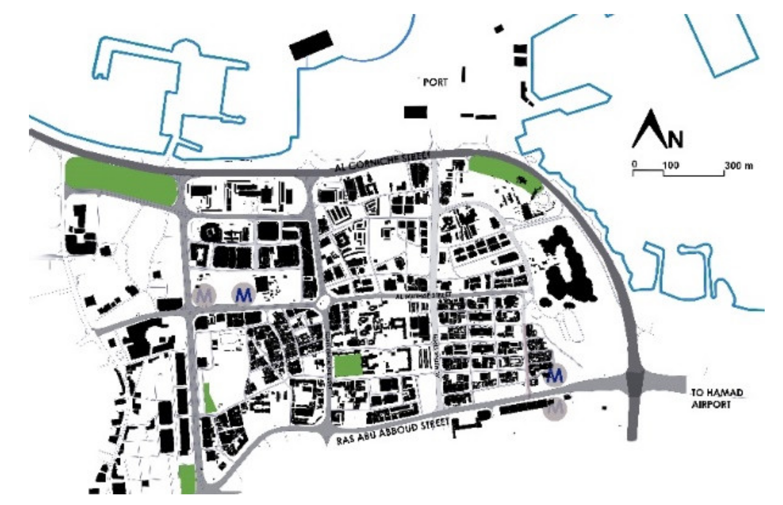
Qatar National Museum Metro (QNM) Station and Souq Waqif Metro station, located on the Doha Metro-Gold line, running east–west from Sports city in the west to Ras abu aboud in the east, form a strong cultural–cultural hub. Figure 3 shows the figure ground map of the study area. Out of 455 blocks in the study area, the average block size is 0.5 acres. Small block size is important in increasing connectivity and facilitating choice of routes for travellers, providing an active environment and opportunity for diversity in design. Block width is an average of 100 m in the residential area of zone 17, which is within the standards of maintaining a maximum of 350 ft for a walkable neighbourhood.
4. Data Analysis and Findings
The resulting place-making approach for planning QNM-Souq Waqif Corridor-TODs summarizes a framework enhancing the dependency between mapping and design. Site analysis through the four pre-identified categories allows us to monitor and assess the potential benefits of the investigated QNM-Souq Waqif corridor-TODs.
4.1. Transportation Network
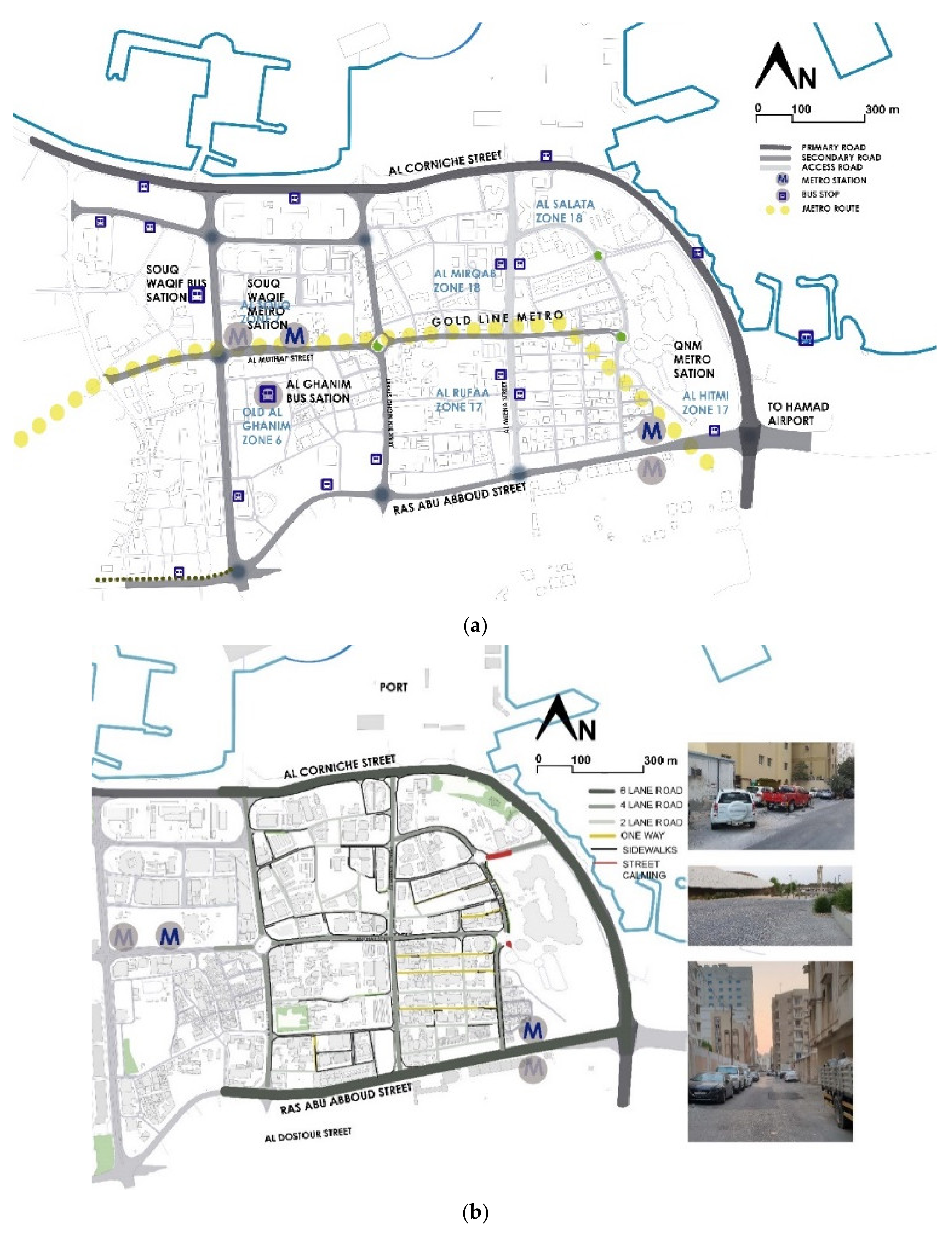
The QNM-Souq Waqif corridor, inclusive of the Souq Waqif and QNM station Metro is approximately 2 km long (Figure 2). In addition, Doha’s underused Bus Rapid Transit system, ‘Mowasalat’ buses has its major Central depots in zone 6 and zone 7 (old Al Ghanim and Al Souq area). Low wage migrant workers who form a major workforce in the construction sector as well as residents of zone 6 and 17 use public transport for travelling to and from these bus depots. Hence, the site is accessible to a large population.
The site is accessible mostly through link roads connecting Corniche Street to the ring roads surrounding Old Doha. An east–west roadway, Al Muthaf Street, runs across zone 17 and 18 and connects the iconic Qatar National Museum and nearby zone of Souq Waqif. Road hierarchy is clear: there are three major roadway types connecting the site (Figure 4a,b). Primary roads are six-lane roads, connected by four lane collector roads. Local connectivity is provided through two-lane access roads. Many of the access roads in zone 17 are narrow one way road with uncontrolled on street parking, causing regular traffic congestions. The major traffic congestion occurs along Corniche Street flowing to and from Hamad Airport as well as West Bay. The road network is well connected with a combination of irregular streets, deformed grids and regular grids making up 39% of the site area. Except for a few local access roads along residential zones, connectivity in the site is two way.
Private vehicles are heavily used along with occasional buses. In general, an overlapping usage of different transit systems is evidently absent since the multi-modal systems are not co-ordinated. However, the recent opening of the Metro has implemented the diffusion of feeder buses at many stations to facilitate users to commute. Travel patterns vary within each zone. Major traffic congestion during work days occurs at peak hours (around 7 a.m./5 p.m.). Bicycle lanes are absent, except along the Corniche Street and the newly opened QNM precincts. Pedestrian pathways are incomplete in most of the access roads, with pavements ending abruptly on-street parking (Figure 4).
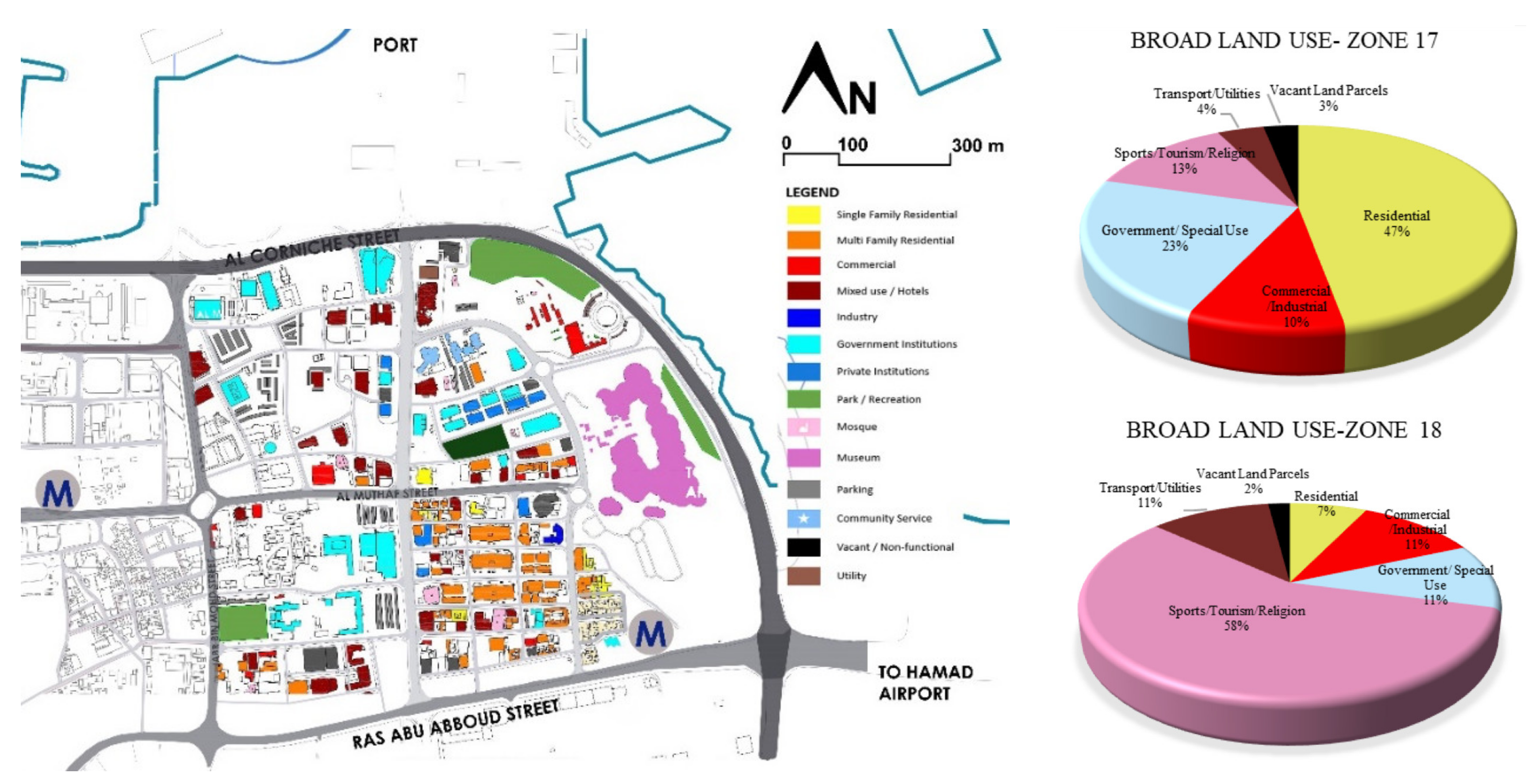
4.2. Land Use
The area is predominantly residential, mixed-use with government offices, hotels, commercial markets and other civic buildings (Figure 5). Zone 17 is a medium-high density neighbourhood, with easy pedestrian access to on-site retail/service establishments. Nearly 50% of the zone is residential. The majority of the housing units are over 6-story apartment-buildings. Mixed use and commercial units are majorly found along north-south and east west connector roads.
Zone 18 is largely mixed-use including Qatar National Museum and several other government offices. With 36 vacant plots, the site displays built forms with different architectural styles. The site accommodates international hotels over 6 stories such as Movenpick Hotel, Doubletree-Hilton Hotel and Orient Pearl.
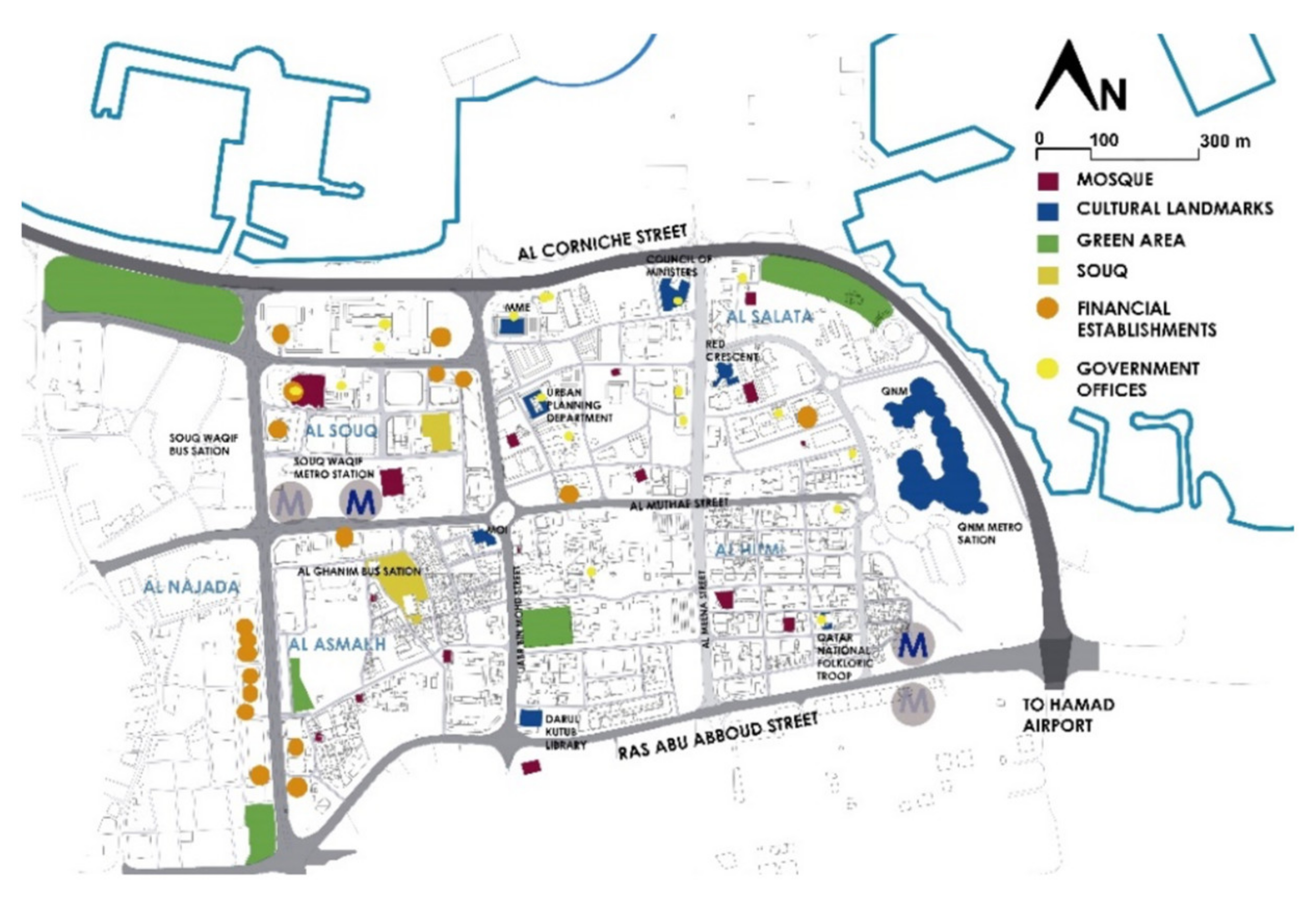
The study area also encloses several public buildings of national and historic significance. Qatar National Museum (the restored Palace of Sheikh Abdullah bin Jassim Al-Thani), the oldest library, Dar Ul Kutub Library, government buildings such as the Ministry of Interior, the Red Crescent building and Folklore theatre (renovated Al Sulaiti house) (Figure 6). Historic mosques such as Ibn Obaid Mosque, Al Yousif Mosque, Mosque near Abdul Rahman house are also present in the area. While public amenities for residents such as government primary schools are rare, primary health care centers are absent in the area.
The public realm, spaces where people congregate such as public parks or nodes are not present: only 2% of the overall area is occupied by public green spaces. The Al Salata park, located near Qatar National Museum, is underutilized due to its poor access from the highway next to it. Overall, the urban architectural form does not harmoniously co-exist with the Souq-Waqif QNM neighbourhood because of design deterrents such as homogeneity, lack of aesthetic stimulation, longer compound walls around apartment buildings, and haphazard on-street parking along road edges (Figure 7).
4.3. Demography and Density
Demography varies within the neighbourhoods. The highest population density is found in Al Hitmi (zone 12), followed by Old Al Ghanim in zone 6. Both areas are resided by low wage migrant labourers from South East Asia, namely India, Pakistan, Bangladesh and Nepal. Out of the total 6026 residents in zone 17, the majority reside in high-rise apartments buildings and low-density deteriorated settlements near QNM Metro station.
Census 2010 data reveal the presence of over 1500 housing units in zone 17: the densest zone within the study area. Zone 18 contains 1000 housing units. With several hotel towers, residential apartments and governmental offices, the resident population of the area is considered lower than the working population.
4.4. Parking and Streetscape
Uncontrolled street parking is extensively visible within the study area. About 33% of the site is vacant (including unbuilt land and open parking spaces). Lack of comprehensive development plans after mid-1980s demolitions resulted in several empty plots, which are utilized for parking purposes (Figure 8). In turn, uncontrolled parking and/or lack of parking regulations, and specifically designated parking areas, cause the residents to park the vehicles in available empty plots, traffic congestion, noise pollution and an overall discomfort in walking along the existing not-continuous pedestrian kerbs. Roadside planting and streetscape elements are absent except along the newly built QNM precincts. Along the residential towers, street pavements are broken and discontinuous, discouraging walkability. Similarly, along the interior narrow cross roads within the study area, parcels are occupied by longer individual apartment units. Urban forms which support single extensive building units reduce stimulation and interest since such buildings have homogenous facades in a longer stretch. In addition, tall compound walls block pedestrian/traveller views of the street.
5. Elements of a Master Plan
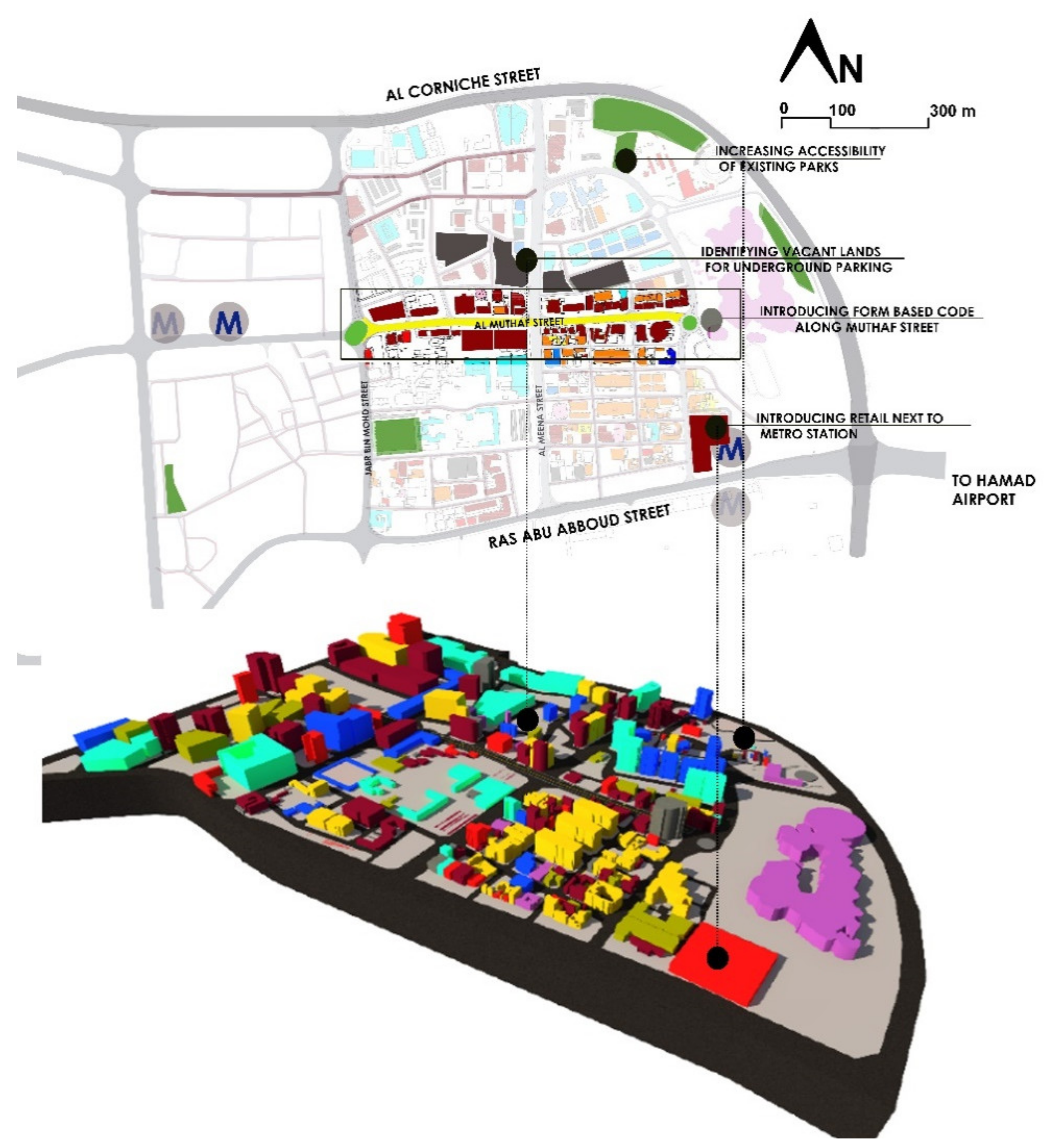
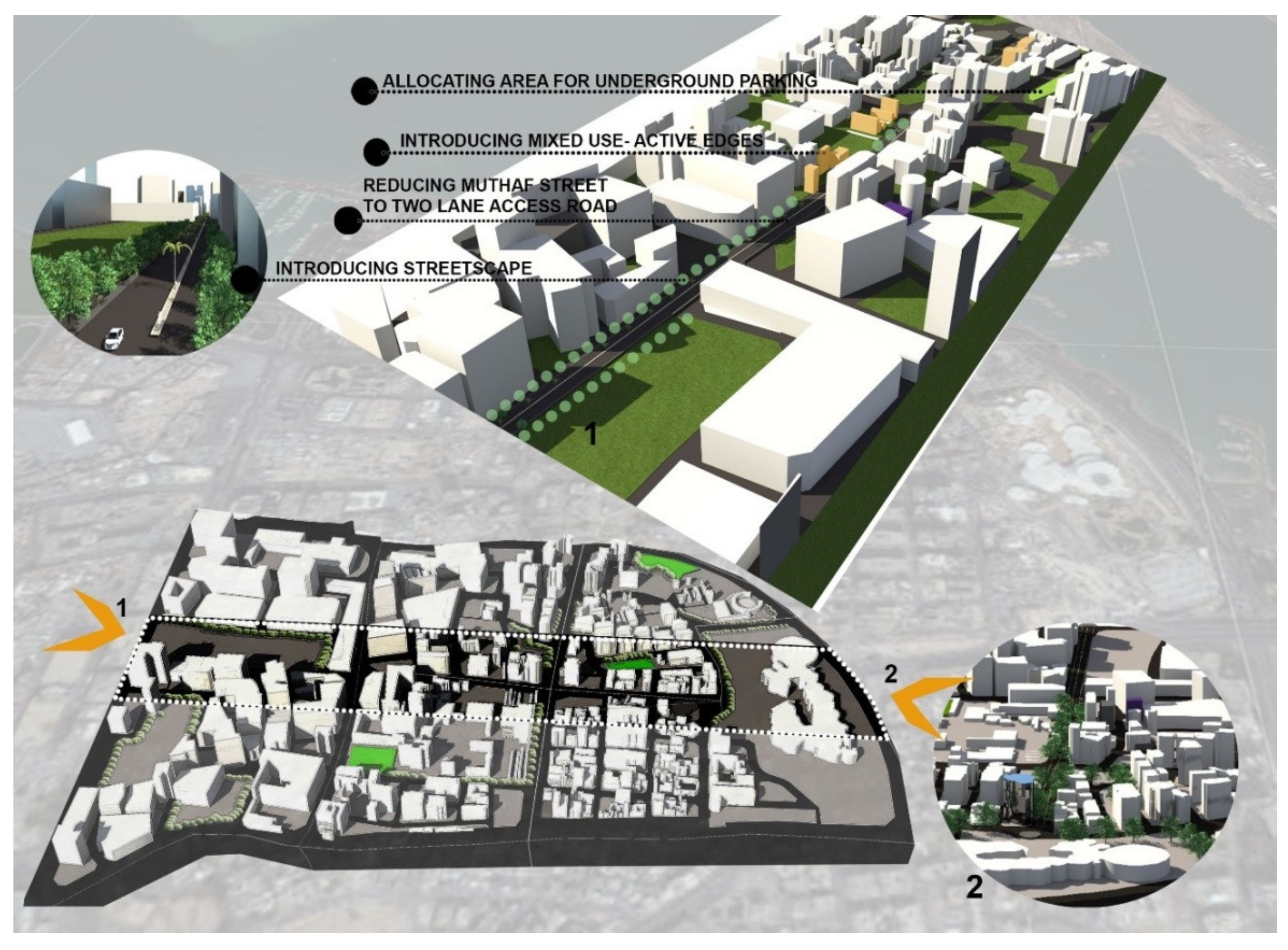
The proposed masterplan and recommendations are based on addressing and filling the gaps highlighted through design tools indicated as the most appropriate for assessing the performance of the selected TODs: (i) Transportation network, (ii) Land Use, (iii) Demography and Density, (iv) Parking and Streetscape. These recommendations are based on the place-making approach in urban design and its further implications in policy guidelines to promote sustainable neighbourhood. Place-making elements identified from the literature are discussed in detail with regard to the study site to gain insights on design guidelines and policy measures for improving overall sense of place. The identified parameters are: (i) Design of public realm, (ii) Urban street character and (iii) Walkability measures to be implemented in the intervention area. From site analysis, a potential ‘transit corridor’, Muthaf Street extending from the National Museum to Souq Waqif Metro, is identified (Figure 9 and Figure 10). Since the corridor extends over 2 km and connects metro stations and two major landmarks; imparting a ‘sense of place’ in the corridor can accentuate the street character and enliven the neighbourhood. Diversification of the street will provide ample reasons for people visiting either of the touristic destinations to choose the corridor as a transit path.
5.1. Public Realm
Streets, which form the primary element of the public realm, are not pedestrian-friendly nor do they attract users in providing a pleasant street walking experience. Broken pavements and uncontrolled on-street parking aggravate the stimulation of interest in streets. Another major issue in the site is the proliferation of parked cars in vacant plots. Since these plots are not fenced or earmarked, they end up crowded with private vehicles.
Ensuring a complete street system by providing equal right of way for all modes of transport including walking and bicycling irrespective of the user’s age and gender will improve the last-mile connectivity necessitated by Metro stations. Providing safe crosswalks at regular intervals, accessible pedestrian signals, median islands and minimizing the crossing distance will ensure safe walking environment. Road dieting can be implemented in Muthaf Street to reduce crossing distance and to allow the formation of landscaped walkways on either side of the roadway. This will also help a large majority of expatriate labourers who rely on cycling within the neighbourhood. Introducing native trees and shrubs interspersed with non-native shady trees along the road edge, with proper screening from the roadway can promote a pleasant and secure walking experience. A distance of 400 m from both the Metro stations along the street can be converted as a ‘shared street’ since a larger crowd is observed near both the landmarks, Souq Waqif and Qatar National Museum. Vacant plots must be fenced either using shady trees or other temporary measures to curb uncontrolled parking. To accommodate the extra vehicles, an underground parking area can be identified near QNM Metro station.
Green areas, such as Al Salata neighbourhood park, designed for leisure and relaxation, are either inaccessible or remotely accessible from the neighbouring urban fabric. For a large population of migrant workers, family parks, such as Salata Park, do not ensure proper space appropriation. Similarly, most apartment buildings in the area are not surrounded by private yards at the ground floor, but by sporadic green areas and open spaces utilized as uncontrolled parking areas. Also, despite having a considerable resident population, the site lacks basic health and education infrastructures such as primary health care centers and schools.
In order to improve accessibility to Salata Park, the accessway must be improved and the vehicular users must be directed to proper parking area. The vacant area next to Souq-Waqif Metro station can be utilized to have events for resident as well as attracting tourists by introducing a wide range of coffee shops, restaurants along with children’s playground areas.
5.2. Parking
The increased on-street parking and an overall lack of attractive design features along the street hinder a smooth transition from QNM Metro station to Souq Waqif Metro station. Vacant spots in the area are taken over by vehicular parking causing an eyesore in terms of street aesthetics. The present chaos of haphazard parking along the street can be solved by allocating a dedicated underground parking facility and reducing the number of lanes. Lane dieting can allow the additional area to be used as pedestrian pathways and bicycle tracks for a large majority of expatriate labourers who rely on cycling within the neighbourhood.
5.3. Mixed-Use Urban Fabric
A mixed-use, high-density urban fabric around QNM Metro station can provide opportunities for small retail malls or shops, which would allow residents to not be forced to drive to larger shopping malls, currently unavailable in the area. This would also revive the renewed version of the retail units of a market place or a souq. At street ground floor level, the introduction of retail stores and coffee shops would enhance livability along the corridor. This would also serve a large number of resident population who are seen unwinding in cafes in the evening. It would also bind the cultural characteristics of the demographic mix of the area who rely on local retail market places.
5.4. Facade–Streetscape
At present, existing retail units in the neighbourhood do not follow any architectural distinction that makes it unique to the cultural heritage of the area. Existing units along Muthaf Street must be rehabilitated to include retail units that activate street frontage. To maintain the aesthetic along the pathway, unique form-based coding hinged on a uniform color coding and cultural aspects of Qatar must be developed.
Coffee shops, museum-related souvenir units, traditional heritage items must be interspersed along the street frontage to activate and to draw interest of the pedestrians using Muthaf Street. This will reinforce the existing resident culture of relaxing over refreshments as well as encourage museum goers to venture outside the museum and explore the street. The architectural language of the urban fabric should also reflect the contemporary iconicity of the museum as well as the heritage value of the Souq Waqif, ensuring harmony in the architectural design of the area. A mixed-use, high-density urban fabric around QNM Metro station can provide opportunities for small retail malls or shops, which would allow residents to not be forced to drive to larger shopping malls, currently unavailable in the area. This would also revive the renewed version of the retail units of a market place or a souq. At street ground floor level, the introduction of retail stores and coffee shop would enhance livability along the corridor. This would also serve a large number of residents seen unwinding in cafes by the evening. It would also bind the cultural characteristics of the demographic mix of the area who rely on local retail market places.
5.5. Walkability
Other important place-making attributes that can revitalize the study area are principle design parameters of Gulf countries under a hot dry climate, mainly the shaded walkable pathways and a restored version of the arcaded retail units of a souq. These additions in the study area will reorient the neighbourhood as a continuation of the cultural hub of Souq Waqif and improve the pedestrian footfall along the identified potential transit corridor. Introducing streetscaping elements, such as the landscaping and hardscaping details outside the Qatar National Museum, can reinvigorate walkability along Muthaf Street to combat climate extremes. Providing proper benches, street crossings, visible signage and dedicated walking/bicycling lane by lane dieting can improve the overall TOD experience around the transit station.
6. Final Remarks
The research identified the potential of developing the Qatar National Museum neighbourhood as transit-oriented development hub by analysing the urban characteristics of the site. Major problems identified in the site include the absence of basic facilities for upholding the livability of the area. Opportunities in the area include transforming the QNM- Souq Waqif linear path as a transit corridor, redesigning street edges and injecting mixed use. Policy guidelines in the study area must consider aspects of the place-making such as regulating future growth with form-based coding based on a distinct architectural style, building density and use; introducing diverse functions in a distinct architectural style to activate street frontages; facilitating multimodal transit options along the corridor by changing the road usage to a shared two-way street; and increasing pedestrian footfall by improving pedestrian walkways and introducing streetscaping elements.
This research study proposes context driven design strategies to enhance the livability of the investigated QNM-Souq Waqif Corridor-TODs. Secondly, it meets an important objective of the Qatar National Vision 2030, a development plan proposed for sustainable development in Qatar by emphasizing public transit and improving the efficiency of transit use. The insights from this research study can contribute to understanding and implementing a framework for place-making of transit towns in Qatar and to extend its application to other potential transit hubs in metropolitan Doha and in the Middle East. With an understanding of place-making design variables, the results can also serve as a starting point for a community-driven place-making approach in further research.
7. Limitations and Future Research
This research has potential limitations. First, public participation and the community needs of the people residing in the study area are not considered in the research. Their needs are assessed based on the analysis of urban design variables rather than on direct interaction. Understanding the local social and cultural values and involving the community in decision-making is a cardinal element for the success of place-making. Further research should focus on addressing place-making strategies with consensus of the community around transit stations and by involving them in the design process. A bottom up management system with community response must be taken as intellectual inputs for the overall transit village’s urban regeneration. Other considerations must include input from multiple stakeholders to understand the impact of design decisions on the economy.
The other limitation is that study does not consider a thorough investigation of the heritage component of the built form while proposing a generic form-based code. Further research must consider mapping the street façade and heritage character of the study area to propose holistic conservation strategies.
Author Contributions
The authors contributed to this research study as follows: Conceptualization, K.M., R.F., L.E., M.E., R.A.-M.; methodology, K.M., R.F., L.E., M.E., R.A.-M.; software, K.M., L.E., M.E.; validation, K.M., R.F., L.E., M.E., R.A.-M.; formal analysis, K.M., R.F., L.E., M.E., R.A.-M.; investigation, K.M., R.F., L.E., M.E.; resources, K.M., R.F., L.E., M.E.; data curation, K.M., L.E., M.E.; writing—original draft K.M., R.F., L.E., M.E., R.A.-M.; preparation; K.M., R.F., L.E., M.E., R.A.-M.; writing—review and editing, K.M., R.F.; visualization, K.M., L.E., M.E., supervision, R.F., R.A.-M.; project administration, K.M., R.F.; funding acquisition, R.F., R.A.-M. All authors have read and agreed to the published version of the manuscript.
Funding
This research study was developed under two grant schemes awarded by Qatar University: Grant ID: NATIONAL CAPACITY BUILDING PROGRAM-NCB-S1—Titled: Re-thinking a Framework for the Urban Regeneration and Preservation of the Transit Villages of Old Salata, QNM, Msheireb and Souq Waqif, along the Cultural-Heritage Doha-Metro Corridor; Grant ID: QUST-1-CENG-2021-16—titled: A Holistic Strategy for the Urban Regeneration of the Souq Waqif Neighbourhood. English editing, proof-reading, and open access (OA) publication fees of this paper were supported by Qatar University (Grant ID: QUST-1-CENG-2021-16).
Data Availability Statement
All data, models, and code generated or used during the study appear in the submitted article.
Acknowledgments
The authors would like to acknowledge the support of Qatar University for creating an environment that encourages scientific research. Also, the authors would like to express their gratitude to the Government of Qatar, especially to the Ministry of Municipality and Urban Planning (MMUP), the Qatar National Council for Culture, Arts and Heritage, the Qatar Rail and Ashghal Governmental Agencies of Doha for their collaboration—for handling relevant visual data and cardinal documents for the purpose of this research study. Finally, the authors thank the anonymous reviewers for their comments, which contributed to an improvement of this paper.
Conflicts of Interest
The authors declare no conflict of interest.
References
- Dittmar, H.; Ohland, G. The New Transit Town: Best Practices in Transit-Oriented Development; Island Press: Washington, DC, USA, 2012. [Google Scholar]
- Salama, A.M.A.; Wiedmann, F. Demystifying Doha: On Architecture and Urbanism in an Emerging City; Ashgate Publishing Company: Farnham, UK, 2013. [Google Scholar]
- Zhang, Y. The Role of Transit-Oriented Development in Urban Planning of Cities in China. Master’s Thesis, University of Florida, Gainesville, FL, USA, 2011. [Google Scholar]
- Curtis, C.; Renne, L.J.L.; Bertolini, L. Transit Oriented Development: Making It Happen; Ashgate Publishing Company: Cornwall, UK, 2009. [Google Scholar]
- Burdett, R.; Rode, P. Shaping Cities in an Urban Age; Phaidon: London, UK, 2018. [Google Scholar]
- Cervero, R.; Kockelman, K. Travel Demand and the 3ds: Density, Diversity, and Design. Transp. Res. Part D Transp. Environ. 1997, 2, 199–219. [Google Scholar] [CrossRef]
- Ewing, R.; Cervero, R. Travel and the Built Environment: A Synthesis. Transp. Res. Rec. 2001, 1780, 87–114. [Google Scholar] [CrossRef] [Green Version]
- A+U. A+U 586 19:07 Transit Oriented ‘Development and Management’; Sustainable Urbanisation Projects from 3; Shinkenchiku-Sha Co., Ltd.: Tokyo, Japan, 2019. [Google Scholar]
- Furlan, R.; AL-Mohannadi, A. The Urban Regeneration-Planning Scheme for the Souq Waqif, Heritage Site of Doha. Sustainability 2020, 12, 7927. [Google Scholar] [CrossRef]
- Aurobindo, O.; Ndebele, R. The Role of 6ds: Density, Diversity, Design, Destination, Distance, and Demand Management in Transit. Oriented Development (Tod). In Proceedings of the NICHE 2014 Neo-International Conference on Habitable Environments, Jalandhar, India, 31 October–2 November 2014. [Google Scholar]
- Knowles, R.D.; Ferbrache, F. Transit Oriented Development and Sustainable Cities: Economics, Community and Methods; Edward Elgar Publishing Ltd.: Cheltenham, UK, 2019. [Google Scholar]
- Renne, J. Measuring the Success of Transit Oriented Development. In Transit Oriented Development: Making It Happen; Curtis, C., Renne, J., Bertolini, L., Eds.; Ashgate Publishing Limited: Farnham, UK, 2009; pp. 241–255. [Google Scholar]
- Bertolini, L. Nodes and Places: Complexities of Railway Station Redevelopment. Eur. Plan. Stud. 1996, 4, 331–345. [Google Scholar] [CrossRef]
- Guowei, L.; Bertolini, L.; Pfeffer, K. Developing a Tod Typology for Beijing Metro Station Areas. J. Transp. Geogr. 2016, 55, 40–50. [Google Scholar]
- Vale, D.S. Transit-Oriented Development, Integration of Land Use and Transport, and Pedestrian Accessibility: Combining Node-Place Model with Pedestrian Shed Ratio to Evaluate and Classify Station Areas in Lisbon. J. Transp. Geogr. 2015, 45, 70–80. [Google Scholar] [CrossRef]
- Mulley, C. Urban Form and Transport Accessibility; Edward Elgar Publishing Limited: Cheltenham, UK, 2012. [Google Scholar]
- Al Thani, S.; Furlan, R. An Integrated Design Strategy for the Urban Regeneration of West Bay, Business District of Doha [State of Qatar]. Designs 2020, 4, 55. [Google Scholar] [CrossRef]
- Board, Transportation Research, Engineering National Academies of Sciences, and Medicine. Effects of Tod on Housing, Parking, and Travel; The National Academies Press: Washington, DC, USA, 2008. [Google Scholar]
- Lund, H. Reasons for Living in a Transit-Oriented Development, and Associated Transit Use. J. Am. Plan. Assoc. 2006, 72, 357–366. [Google Scholar] [CrossRef]
- Tannous, H.; Furlan, R.; Major, M. The Souq Waqif Neighbourhood as a Transit-Oriented Development (TOD). J. Urban Plan. Dev. 2020, 146, 05020023. [Google Scholar] [CrossRef]
- Gehl, J.; Svarre, B. How to Study Public Life; Island Press: Washington, DC, USA, 2013. [Google Scholar]
- Gehl, J. Life between Buildings: Using Public Space; Island Press: New York, NY, USA, 2011. [Google Scholar]
- Bay, J.H.P.; Lehmann, S. Growing Compact-Urban Forem, Density and Sustainability; Routledge: New York, NY, USA, 2017. [Google Scholar]
- Chatman, D.G. Residential Choice, the Built Environment, and Nonwork Travel: Evidence Using New Data and Methods. Environ. Plan. 2009, 41, 1072–1089. [Google Scholar] [CrossRef]
- Lund, H.M.; Cervero, R.; Willson, R. Travel Characteristics of Transit-Oriented Development in California; California Department of Transportation: Sacramento, CA, USA, 2004.
- Hall, T.; Barrett, H. Urban Geography; Routledge: New York, NY, USA, 2018. [Google Scholar]
- Gottdiener, M.; Hohle, R.; King, C. The New Urban Sociology; Routledge: New York, NY, USA, 2019. [Google Scholar]
- Currie, G.; Stanley, J. Investigating Links between Social Capital and Public Transport. Transp. Rev. 2008, 28, 529–547. [Google Scholar] [CrossRef]
- Saliba, R. Urban Design in the Arab World: Reconceptualizing Boundaries; Ashgate: Burlington, VT, USA, 2015. [Google Scholar]
- Jodidio, P.; Halbe, R. The New Architecture of Qatar; Skira Rizzoli: New York, NY, USA, 2015. [Google Scholar]
- Rizzo, A. Rapid Urban Development and National Master Planning in Arab Gulf Countries. Qatar as a Case Study. Cities 2014, 39, 50–57. [Google Scholar] [CrossRef]
- Molotch, H.; Ponzini, D. The New Arab Urban Guld Cities of Wealth, Ambition, and Distress; New York University Press: New York, NY, USA, 2019. [Google Scholar]
- Adham, K. Rediscovering the Island: Doha’s Urbanity from Pearls to Spectacle. In The Evolving Arab City: Tradition, Modernity and Urban Development; Elsheshtawy, Y., Ed.; Routledge: New York, NY, USA, 2011. [Google Scholar]
- Fromherz, A.J. Qatar-Rise to Power and Influence; I.B Tauris & Co. Ltd.: London, UK, 2017. [Google Scholar]
- Remali, A.M.; Salama, A.M.; Wiedmann, F.; Ibrahim, H.G. A Chronological Exploration of the Evolution of Housing Typologies in Gulf Cities. City Territ. Archit. 2016, 3, 14. [Google Scholar] [CrossRef] [Green Version]
- Rizzo, A. Metro Doha. Cities 2013, 31, 533–543. [Google Scholar] [CrossRef]
- Wiedmann, F.; Salama, A. Building Migrant Cities in the Gulf: Urban Transformation in the Middle East; Bloomsbury Publishing: London, UK, 2019. [Google Scholar]
- Marshall, C.; Rossman, G.B. Designing Qualitative Research, 3rd ed.; Sage Publication: Thousand Oaks, CA, USA, 2014. [Google Scholar]
- Denzin, N.K.; Lincoln, Y.S. The Sage Handbook of Qualitative Research; Sage Publications: London, UK, 2011. [Google Scholar]
- Handasa, D.-A. Doha Inner City Redevelopment; Ministry of Municipal Affairs: Doha, Qatar, 1984.
- Carter, R.; Eddisford, D. Origins of Doha Project: Season 1. Available online: http://www.academia.edu/5144073/Origins_of_Doha_Season_1_Archive_Report (accessed on 6 January 2019).
Figure 1.
The research design.

Figure 2.
Site context and Metro stations in the study area.

Figure 3.
Figure ground map of the study area showing percentage area of different uses.

Figure 4.
(a) Transportation network of the study area. (b) Street hierarchy of the study area.

Figure 5.
Land use map and broad land use percentage in zones 18 and 17 respectively.

Figure 6.
Landmarks in the study area.

Figure 7.
Building heights and population density in study area.

Figure 8.
Street character along Muthaf Street.

Figure 9.
Proposed masterplan—Muthaf Street.

Figure 10.
Place-making considerations along Muthaf Street.

Publisher’s Note: MDPI stays neutral with regard to jurisdictional claims in published maps and institutional affiliations. |
© 2021 by the authors. Licensee MDPI, Basel, Switzerland. This article is an open access article distributed under the terms and conditions of the Creative Commons Attribution (CC BY) license (http://creativecommons.org/licenses/by/4.0/).
Share and Cite
MDPI and ACS Style
Marthya, K.; Furlan, R.; Ellath, L.; Esmat, M.; Al-Matwi, R. Place-Making of Transit Towns in Qatar: The Case of Qatar National Museum-Souq Waqif Corridor. Designs 2021, 5, 18. https://0-doi-org.brum.beds.ac.uk/10.3390/designs5010018
AMA Style
Marthya K, Furlan R, Ellath L, Esmat M, Al-Matwi R. Place-Making of Transit Towns in Qatar: The Case of Qatar National Museum-Souq Waqif Corridor. Designs. 2021; 5(1):18. https://0-doi-org.brum.beds.ac.uk/10.3390/designs5010018
Chicago/Turabian StyleMarthya, Khalida, Raffaello Furlan, Labeeb Ellath, Maha Esmat, and Rashid Al-Matwi. 2021. "Place-Making of Transit Towns in Qatar: The Case of Qatar National Museum-Souq Waqif Corridor" Designs 5, no. 1: 18. https://0-doi-org.brum.beds.ac.uk/10.3390/designs5010018