Article

Multi-Decadal Forest-Cover Dynamics in the Tropical Realm: Past Trends and Policy Insights for Forest Conservation in Dry Zone of Sri Lanka

by
Manjula Ranagalage
1,2,*,
M. H. J. P. Gunarathna
3,
Thilina D. Surasinghe
4,
Dmslb Dissanayake
2,
Matamyo Simwanda
5,
Yuji Murayama
1,
Takehiro Morimoto
1,
Darius Phiri
5,
Vincent R. Nyirenda
6,
K. T. Premakantha
7 and
Anura Sathurusinghe
7
1
Faculty of Life and Environmental Sciences, University of Tsukuba, 1-1-1, Tennodai, Tsukuba, Ibaraki 305-8572, Japan
2
Department of Environmental Management, Faculty of Social Sciences and Humanities, Rajarata University of Sri Lanka, Mihintale 50300, Sri Lanka
3
Department of Agricultural Engineering and Soil Science, Faculty of Agriculture, Rajarata University of Sri Lanka, Anuradhapura 50000, Sri Lanka
4
Department of Biological Sciences, Bridgewater State University, Bridgewater, MA 02325, USA
5
Department of Plant and Environmental Sciences, School of Natural Resources, Copperbelt University, P.O. Box 21692, Kitwe 10101, Zambia
6
Department of Zoology and Aquatic Sciences, School of Natural Resources, Copperbelt University, Kitwe 10101, Zambia
7
Forest Department, Ministry of Environment and Wildlife Resources, 82, Rajamalwatta Road, Battaramulla 10120, Sri Lanka
*
Author to whom correspondence should be addressed.
Submission received: 30 June 2020 / Revised: 24 July 2020 / Accepted: 28 July 2020 / Published: 1 August 2020

Abstract

:
Forest-cover change has become an important topic in global biodiversity conservation in recent decades because of the high rates of forest loss in different parts of the world, especially in the tropical region. While human interventions are the major cause, natural disasters also contribute to forest cover changes. During the past decades, several studies have been conducted to address different aspects of forest cover changes (e.g., drivers of deforestation, degradation, interventions) in different parts of the world. In Sri Lanka, increasing rates of forest loss have been recorded during the last 100 years on a regional basis, especially in the dry zone. However, Sri Lanka needs detailed studies that employ contemporary data and robust analytical tools to understand the patterns of forest cover changes and their drivers. The dry zone of Sri Lanka encompasses 59% of the total land area of the country, ergo, the most extensive forest cover. Our study analyzed forest cover dynamics and its drivers between 1992 and 2019. Our specific objectives included (i) producing a forest cover map for 2019, (ii) analyzing the spatiotemporal patterns of forest cover changes from 1992 to 2019, and (iii) determining the main driving forces. Landsat 8 images were used to develop forest-cover maps for 2019, and the rest of the forest cover maps (1992, 1999, and 2010) were obtained from the Forest Department of Sri Lanka. In this study, we found that the dry zone had undergone rapid forest loss (246,958.4 ha) during the past 27 years, which accounts for 8.0% of the net forest cover changes. From 2010 to 2019, the rates of forest loss were high, and this can be associated with the rapid infrastructure development of the country. The findings of this study can be used as a proxy to reform current forest policies and enhance the forest sustainability of the study area.

Graphical Abstract

1. Introduction

Despite multifaceted environmental values of forests, extraction-based ventures, including commercial lumbering, paper, and pulp industries, have dominated the forestry sector since the 1800s [1]. Recently, non-consumptive uses of forests, such as carbon sequestration, water resource, and soil protection, ecotourism, and wildlife management, have garnered the attention of forest managers and conservation authorities around the world leading to sustainable forest management and improved silvicultural operations [2,3]. Nonetheless, imbalances of demand and supply of forest products due to increasing population growth coupled with deforestation in the face of agricultural expansion, rural human settlements, urbanization, and infrastructure development still threaten forest ecosystems [4,5]. The Millennium Ecosystem Assessment (2015) estimated a 3% loss of world forest cover from 1990 to 2015 [6]; however, the loss of natural forest cover for the same timeframe was estimated at 6%. While spatiotemporal variations of forest cover exist at continental, ecoregional, and country levels, robust quantifications of forest dynamics are often impeded by data deficiencies, an issue common to biodiversity-rich ecoregions like South Asia [6,7]. Several studies [8,9,10,11] investigated the deforestation dynamics of south Asia [12] and reported significant spatiotemporal variations in forest cover. Since reliable quantifications of spatiotemporal forest cover dynamics are needed to inform policies, conservation actions, and sustainable natural resource management [6,12,13], in this study, we assessed long-term forest-cover change in the south Asian tropical Sri Lanka, which has undergone a significant rate of forest cover loss, especially during the past few decades [9].
Deforestation is a primary driver of forest loss in the humid tropical region [11,12,14,15,16], and this situation is not different in Sri Lanka [9,10,17]. However, forest cover changes in Sri Lanka are much complicated, particularly because of multiple land-use transitions evident throughout Sri Lankan history [18,19]. Large-scale forest cover losses in Sri Lanka have been attributed to plantation agriculture, slash-and-burn farming, abandonment of ancient civilizations, and new rural settlement programs as well as the industrial revolution [9,19,20,21]. Sri Lanka’s forest cover statistics show rapid deforestation from 1956 to 2010. In 1956, nearly half of the island (44.2%) had forest cover. However, rapid forest losses have been recorded in the recent decades: 37.5% in 1983, 31.2% in 1992, 29.6% in 1999, and 28.7% in 2010 [9,22]. Although, the impacts of deforestation on environmental and socio-economic aspects of Sri Lanka have been well addressed [8,9,10,19,23,24,25], only a few studies have quantified long-term forest cover changes in Sri Lanka [9]. Most of the existing studies that quantified Sri Lanka’s deforestation are limited by either the geographical extent or the timeframe [8,10,19,24]. Furthermore, albeit studies on forest cover change in Sri Lanka have mostly focused on deforestation in rainforest biomes in southwestern wet lowlands and central highlands [19,26], only a few studies [10,27] reported forest-cover dynamics in the Dry Zone (DZ). Nonetheless, those studies failed to systematically analyze, deforestation, forest regrowth, and forest plantations on a long-term basis.
Sri Lanka is a small (65,610 km2) Indian-oceanic island, with rich fauna and flora. Based on the annual average precipitation, three bioclimatic zones have been identified in Sri Lanka: wet, intermediate, and DZ [28]. Nearly two-thirds of the island falls within the DZ, which contains Sri Lanka’s most extensive forests, amounting to 76% of the island’s total forest cover. Thus, the DZ forest cover exceeds that of the other two bioclimatic zones combined [10,28]. During the recent decades (1992 to date), human resettlements, agricultural encroachments, and infrastructure development have driven substantial forest losses in the DZ, while multiple dry-zone areas have been identified as deforestation hotspots [9,29,30].
Understanding the spatiotemporal forest dynamics is crucial for the conservation and sustainable management of the forest resources in the DZ [12]. In addition, the availability of spatially explicit data with sufficient temporal resolution is paramount for the assessment of spatiotemporal changes of forest cover [25,31]. Accurate and up-to-date information over the period of interest is essential to quantify spatiotemporal forest-cover changes. Fortunately, recent advancements in Geographic Information Systems (GIS), Remote Sensing (RS), machine-learning algorithms, and high-performance computing have made considerable contributions in spatially explicit data collection and processing, analyses, and interpretations with respect to forest resources management. RS data can be effectively used to derive forest-cover calculations because of their consistency in data acquisition, reproducibility, and availability in locations where ground-based knowledge is sparse or non-existent [32].
In this study, we focused on the DZ of Sri Lanka. We obtained three forest cover maps (1992, 1999, and 2010) from the Sri Lankan Forest Department and applied open-access RS data, and GIS applications to: (i) produce a forest cover map for 2019 and (ii) comparatively analyze the spatiotemporal patterns of forest cover changes using obtained from 1992 to 2019; as well as (iii) determine the main driving forces of the forest-cover changes. Our study provides a knowledge base for policy-makers and government organizations to improve the policy framework for implementing sustainable forest resource management in Sri Lanka and similar other regions of tropical southern Asia.

2. Materials and Methods
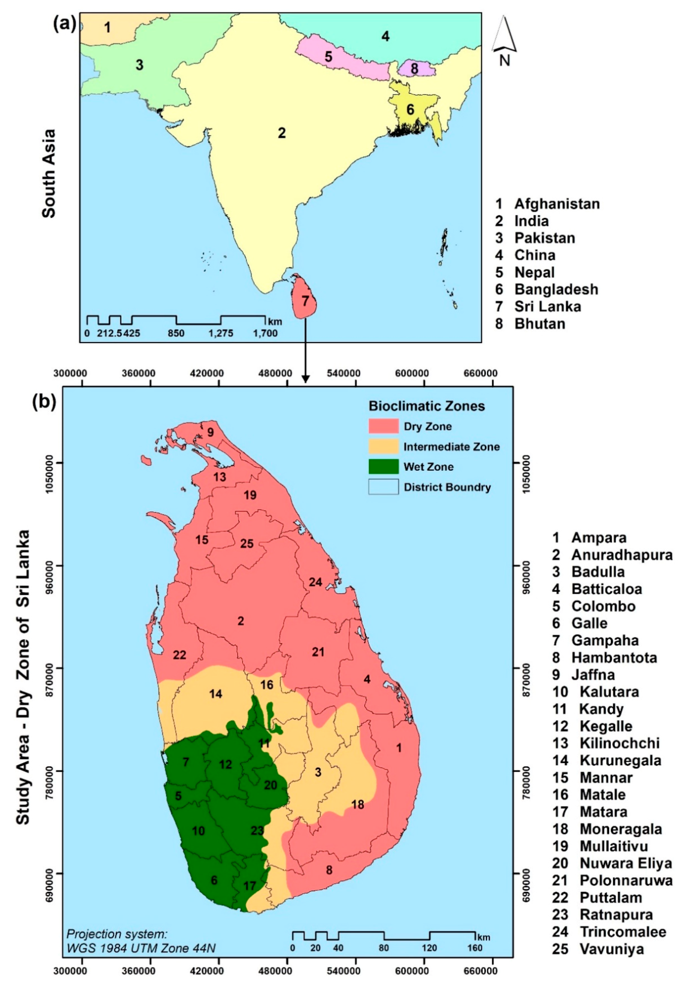
2.1. Study Area

This study focused on the DZ of Sri Lanka. The DZ encompasses the Northern, Eastern, and extreme Southeastern parts of Sri Lanka and excludes the Southwestern part as well as the central massif (Figure 1). The DZ has a total land area of 3,889,252 ha that covers about 59% of the total land area of Sri Lanka. The area is primarily influenced by monsoon rains and has four different forest types: tropical dry evergreen forests, tropical thorn forests, riverine dry forests, and mangroves [10,29,30,33]. Administratively, the DZ spans across eight provinces: Northern, Eastern, North Western, North Central, Central, Sabaragamuwa, Southern, and Uva provinces. Much of the DZ is comprised of lowlands (elevation: 0 to 836 m) with some scattered undulating surface topography (slope: 0 to 63°) and isolated residual mountains [34]. The DZ exhibits a humid-tropical climate with mean annual precipitation of 1500 mm, mean annual evaporation of 1400 mm, and a mean annual temperature of 33 °C [28,35].
This area had a long history of hydrologic civilization as the first (Anuradhapura, 377 BC–1017 AD) and the Second kingdoms (Polonnaruwa, 1056–1236 AD) of ancient Sri Lanka [36]. During hydrologic civilization, over 10,000 reservoirs were constructed for irrigation purposes. In the post-colonial era (after 1948), several government-sponsored rural development programs supported human resettlements in the DZ [37]. “Mahaweli Development project (MDP)” is a notable multipurpose development scheme where primary intensions were human settlement hydroelectricity generation and farmland irrigation [38]. These state interventions have led to both population increase and major land-cover transformations in the DZ.

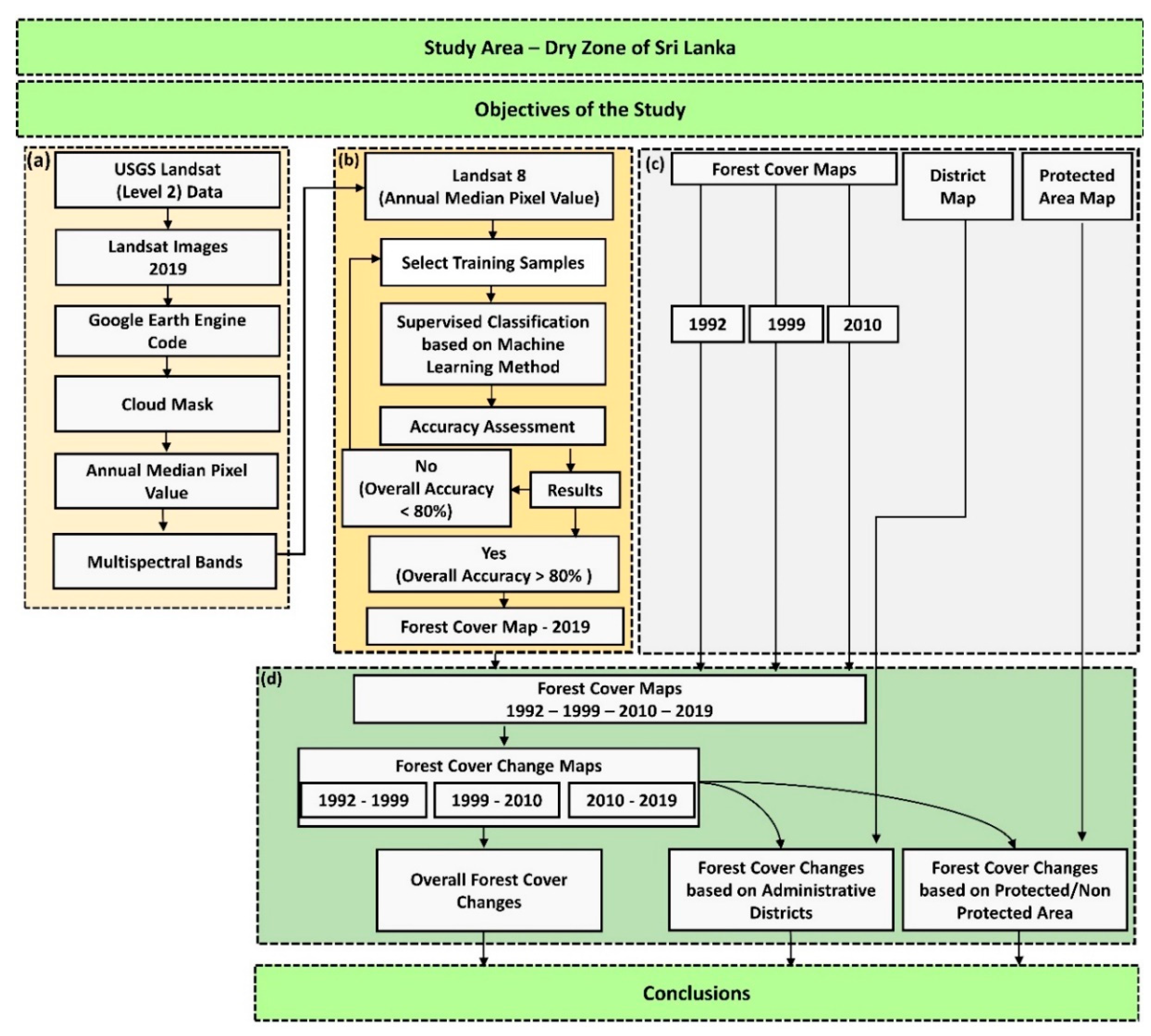
2.2. Overall Workflow

In this study, we used medium-resolution (30 m) satellite imagery (Landsat-8 OLI/TIRS) to classify the forest cover in the DZ for the year 2019. Previous forest cover assessments in Sri Lanka have also used Landsat data for documenting forest cover changes [23], mapping baseline forest distribution [39], and classifying forests in the southern part of Sri Lanka [40].
The methods adopted (Figure 2) in our study followed four main steps: (a) pre-preparation of the Landsat images with the Google Earth Engine (GEE) [41]; (b) forest cover classification for 2019 via the supervised classifications methods with follow-up accuracy assessments; (c) acquisition and pipelining secondary data layers available through standard GIS data formats, and (d) calculating forest-cover changes.

2.3. Data and Pre-Processing

The application of Landsat images in land-cover classifications presents challenges, particularly due to cloud cover and shadow effects, especially in the tropical regions [42,43]. To obtain cloud-free imagery, we used GEE. The capacity of GEE for large-scale land-cover mapping and vegetation characterization via supervised classifications have been demonstrated in numerous recent studies [41,44,45,46]. We used GEE to extract the annual median pixel of the year 2019. GEE uses pre-processed atmospherically corrected Landsat (Level 2) images to provide an annual median pixel of that year in each band. We used a 50% cloud-cover mask and then generated the annual median pixels for the DZ based on 125 images. This process yielded high-quality cloud and shadow-free images and resolved spectral noise resulting from seasonal changes in the vegetation. The extracted multispectral bands (annual median pixels) were used for forest cover classification for the year 2019 (Section 2.4).
To aid in the analysis of forest cover changes from 1992 to 2019, we obtained three forest cover maps for 1992, 1999, and 2010 from the Forest Department of Sri Lanka and district boundaries from the Survey Department of Sri Lanka (shapefiles). In terms of pre-processing, we examined all GIS datasets and corrected geospatial and geometric errors. Based on the spatial extent of our study area, forest patches less than 20 ha were eliminated from all forest cover maps as those fragments were too small to detect any tangible changes. In addition, we accessed Sri Lanka’s protected area shapefiles from the World Database on Protected Areas [47].

2.4. Forest Cover Classification, 2019

We adopted a binary classification scheme, forest (including mangroves and forest plantations) and versus non-forest, to classify the 2019 Landsat 8 imagery (extracted in Section 2.3) based on four supervised machine learning algorithms (i.e., support vector machines, neural networks, random forest, and K-nearest neighbor) available in R statistical software (Version 3.6.2) [48]. We used 4335 training samples (points) to maintain the uniformity of the forest cover classification [49]. Subsequently, we selected the machine learning method with both the best prediction performance using Cohen’s Kappa statistic and the highest accuracy via an overall accuracy assessment [50,51,52]. For the post-classification correction, we utilized both majority filters and hybrid classifications to reach greater classification accuracy [53,54]. To carry out the accuracy assessment, we first generated 1000 random sampling points via a stratified random sampling technique [55]. We used Google Earth imagery as a reference to produce a confusion matrix (Figure 2). After completing the accuracy assessment, a classified 2019 forest map was converted to vector formats to maintain uniformity of the data set with the forest maps for 1992, 1999, and 2010.

2.5. Forest Cover Changes
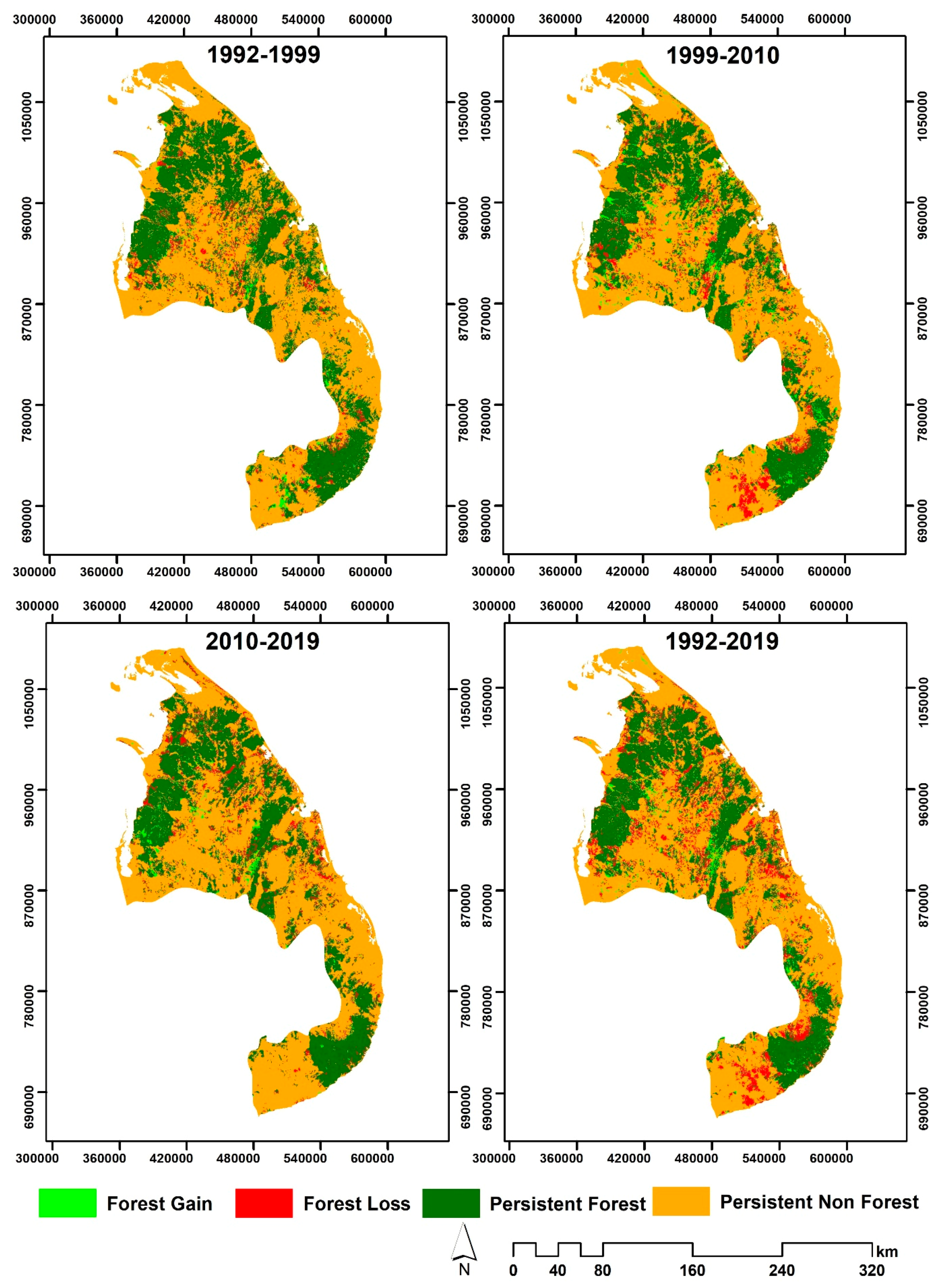
We analyzed forest cover changes in three different ways; (i) forest-cover changes in the entire DZ; (ii) forest cover changes within each administrative district within the DZ; and (iii) forest cover changes both within and outside protected areas of the DZ. First, we calculated the area of forest cover in the DZ using forest cover maps for 1992, 1999, 2010, and 2019. Then, using the intersect spatial analyst tool in ArcGIS 10.6, we assessed the forest cover changes in the periods 1992–1999, 1999–2010, and 2010–2019. Afterwards, the area of persistent non-forest (areas where no changes were noted in non-forest land cover across the timeframe of interest), persistent forest (areas where no changes were noted in forest cover across the timeframe of interest), forest cover gain (changes from non-forest to forest), and forest cover loss (changes from forest to non-forest) were extracted. In this forest cover change analysis, we used vector data analysis (as opposed to raster analysis) since the forest cover maps from the Forest Department was provided in vector format. Additionally, we extracted forest cover change statistics for each administrative district within the DZ, as well as inside and outside protected areas. Seventeen administrative districts overlapped the DZ (Figure 1), and only those that had a minimum of 25% extent within the DZ were included in our district-wise assessment.

3. Results

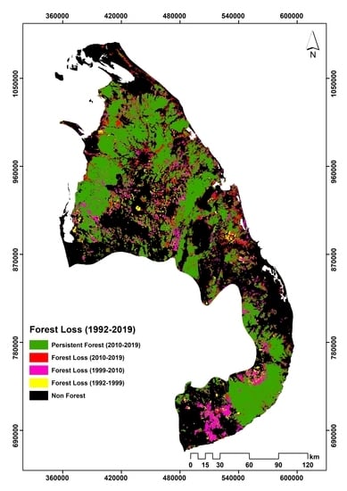
3.1. Forest Cover in the DZ, Sri Lanka

Among the four machine-learning algorithms we employed, the support vector machine provided the best solution in overall classification accuracy (96%) (Table A1). These metrics are deemed acceptable in terms of both algorithm performance (>0.75) and classification accuracy (>80%). In 1992, the total forest cover of the DZ was 1,624,757.5 ha, which accounted for 41.8% of the entire DZ land area (Table 1). By 1999, the forest cover declined to 1,557,520.9 ha, while the percent forest extent in the DZ dropped to 40% (Table 1). The downturn in the forest area was also evident in 2010 (1,508,148.6 ha), where the forest cover fraction in the DZ fell below 40% (Table 1). The forest loss continued to exacerbate by the turn of the next decade, where DZ forests shrunk close to a third of the land area (1,377,799.1 ha; Table 1).
The DZ has undergone rapid forest cover changes from 1992 to 2019, where the overall trend exhibited forest loss. For nearly three decades (27 years), the DZ suffered 246,958.4 ha of forest loss at a rate of 9146 ha yr−1. During the early phase of our analyses (1992–1999), the net forest loss in DZ was approximately 67,236.6 ha at an annual rate of 9605.2 ha yr−1 (Figure 3, Table 1). In the middle decade (1999–2010) of our analyses, the forest losses lessened remarkably compared to both the preceding and succeeding timeframes where the net forest cover change summed up to 49,372.3 ha while the annual forest-loss rate halved compared to the previous timeframe (4488.4 ha yr−1). In stark contrast, we recorded precipitous extents of net forest losses during the most recent decade (2010–2019). Hereto, the DZ experienced at least a two-fold rise (130,349.5 ha) in net forest-cover decline compared to the two previous timeframes. Likewise, the annual rate of DZ forest loss during the 2010–2019 timeframe corresponded to a three-fold increase (14,483.3 ha yr−1) compared to the preceding (1999–2010) timeframe. The continuous downturn in the persistent forest cover during the first two timeframes was also noteworthy (from 1432,855.7 ha between 1992 and 1999 to 1284,650.6 ha between 1999 and 2010). However, the persistent forest cover remained relatively stable by the end of 2019 as the DZ only lost less than 600 ha of persistent forests (Table 1). The overall forest loss of the DZ is shown in Figure A2 for details visual interpretations.

3.2. Forest Cover and Its Changes in the DZ Based on Administrative Districts

Although the DZ falls across 17 administrative districts of Sri Lanka, only 13 districts (25% of the total area of the district fell into the DZ) were considered for our study (Table A2). Anuradhapura district located in North-central Sri Lanka recorded the highest dry zonal forest cover for all the four years of our analyses, where the forest cover remained over 240,000 ha (297,785.4 ha to 242,763.0 ha, from 1992 to 2019, respectively) during the multi-decadal time frame (Table A2). Administrative districts in northern, north-central, and east-central parts of Sri Lanka continued to sustain appreciable forest extents within the DZ (Table A2). In contrast, Jaffna district recorded the lowest forest cover in all the years (1139.3 to 1881.4 ha, from 1992 to 2019, respectively).
During our initial (1992–1999) timeframe, both Hambantota and Jaffna districts showed a net forest-cover gain (5651.8 ha, and 109.2 ha, respectively). Anuradhapura and Batticaloa districts underwent the highest and lowest forest losses in the DZ, respectively (Table A2). Forest cover dynamics during the middle (1999–2010) timeframe marked a cornerstone as many Northern and Eastern districts showed net forest gains, although some southern and northwestern districts suffered forest losses. Most districts that gained forests in the 1999–2010 decade suffered forest losses in the prior decade (Table A2). During the most recent decade (2010–2019), all but Puttalam district showed variable degrees of forest decline. Hereto, the forest losses exceeded 10,000 ha in seven districts (Table A2). On the contrary, Puttalam district (Northwestern Sri Lanka) had a net forest expansion (5503.1 ha) despite the substantial net forest loss in the previous two decades. During the recent most timeframe, the most severe forest losses were reported in Trincomalee, Mullaitivu, and Batticaloa districts (~18,000 ha) (Table A2), implying a northerly and easterly bias in severe forest declines.
Among district-wise forest cover dynamics, notable trends were observed in Anuradhapura, particularly since it ranked foremost in both forest gain and loss, as well as in a persistent forest-cover change throughout all timeframes while the overall trend suggested a declining forest cover pattern (Table A3). In general, forest-cover dynamics in Jaffna opposed that of most other districts, although northern and eastern districts (Jaffna, Mannar, Mullaitivu, Kilinochchi, Vavuniya, Batticaloa, and Trincomalee) recorded comparatively higher forest losses. Across the three decades of our analyses, the greatest forest cover loss, as well as the lowest forest gain, appeared in the most recent decade (2010–2019). Although forest loss continued to plummet through Sri Lanka’s DZ, a handful of districts, southern and northwestern, in particular, showed a deceleration in forest losses at least between the two decades.

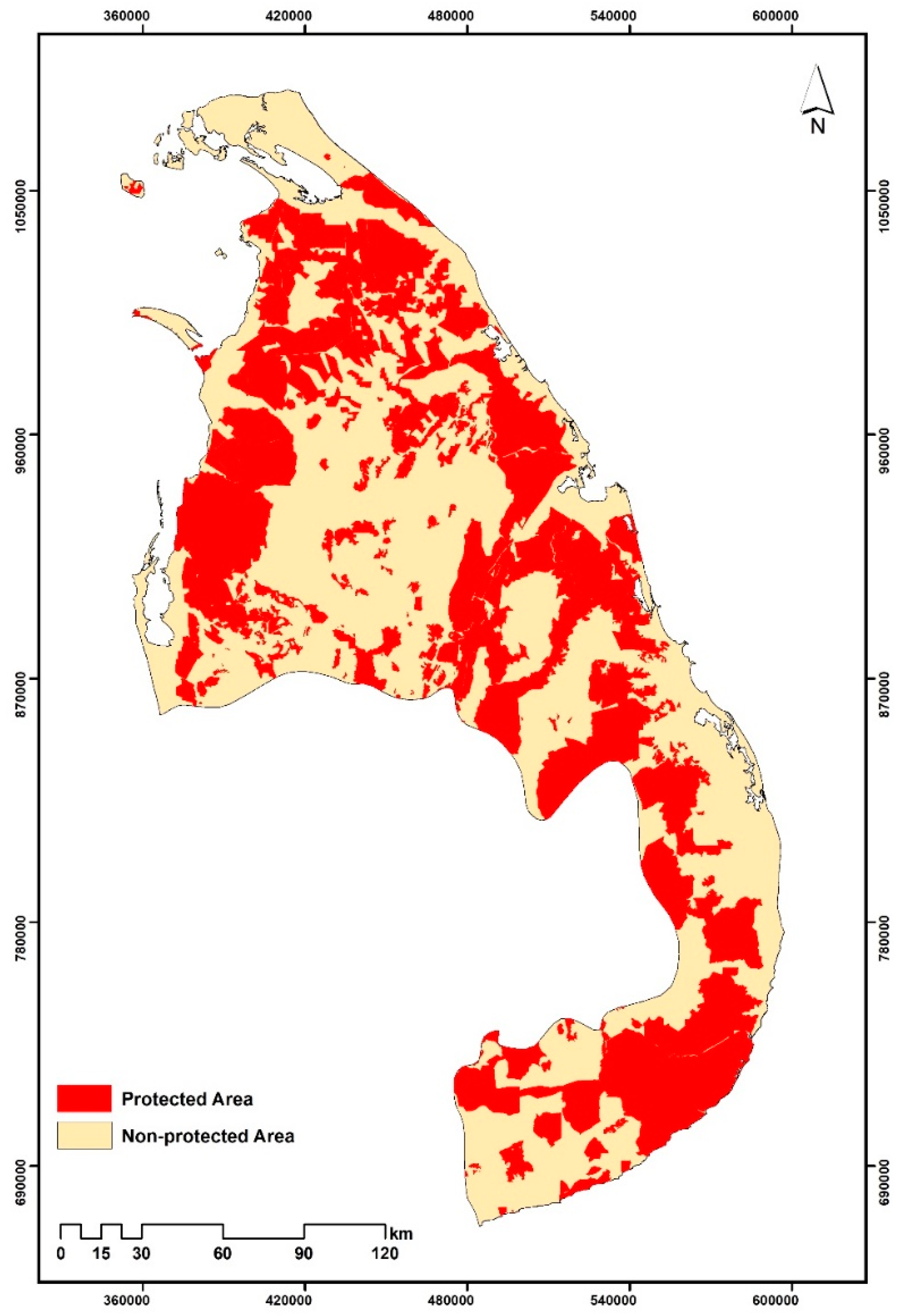
3.3. Forest Cover Changes in DZ, Based on Protected Area and Non-Protected Area

Our comparative analyses on forest cover changes inside versus outside protected areas (Figure A1) suggested a clear temporal pattern of continuous forest loss outside the protected areas of Sri Lanka’s DZ (Figure 4). Forest loss evident inside the protected areas was negligible than the dramatic forest loss in unprotected lands (Figure 4). The forest cover inside dry zonal protected areas remained relatively stable and high (forest cover lessened from 67% to 62%) in contrast to the equivalent figures from unprotected lands (forest cover dropped from 22% to 14%). Similar inferences can be derived for persistent forest cover as well, where forest persistence was mostly observed inside protected areas.

4. Discussion

4.1. Patterns, Trends, and Drivers of Forest Cover Change in the DZ of Sri Lanka

In this study, we examined forest cover dynamics in the DZ of Sri Lanka for nearly three decades (1992–2019). Our results revealed that the DZ of Sri Lanka had undergone considerable forest loss over the past three decades with net forest losses amounting to 246,958.4 ha, (at a rate of 9146.6 ha yr−1). The forest area gained in Sri Lanka’s DZ for the same timeframe was much lower (162,676.6 ha) in comparison to gross forest loss (409,635.0 ha). As such, forest regeneration (6025.1 ha yr−1) only compensated for less than half the forest losses (15,171.7 ha yr−1). However, the forest cover dynamics in the DZ of Sri Lanka are complicated, non-deterministic, non-uniform across dry-zone landscapes, and characterized by decadal temporal variations in deforestation and afforestation. Forest cover transformations we quantified, particularly the deforestation hotspots we identified in south-eastern and northernmost Sri Lanka, are inconsistent with other studies [11].
Intensive, state-subsidized socio-economic development projects targeting rapid agrarian development in the DZ were observed both within and prior to our timeframe of interest is the likely primary cause of forest cover loss [56,57,58]. The political and socio-economic movements underlying these developmental schemes transformed the farming practices of the DZ from a subsistence economy founded on local markets into a competitive commercial enterprise centering the national market [59]. In tropical countries with agrarian livelihoods and extractive farming systems, rural populations heavily rely on limited natural resources, which ultimately leads to forest degradation. This phenomenon has been observed throughout southern Asia and South America [6,60].
During the 1999–2010 timeframe, we observed the lowest levels of forest loss (49,372.3 ha) as well as the greatest gain in forest cover (223,498 ha) in the DZ. The expansion of forest cover during this timeframe is most notable in Northern and Eastern districts. Sri Lanka endured a three-decade-long civil war, where Northern and Northeastern parts of the country became conflict zones. The subsequent abandonment of human settlements relieved landscapes from human disturbances (agricultural encroachment in particular) and triggered rapid forest regeneration, despite increased incidences of illicit timber harvesting [61]. In addition, due to both warfare and human-elephant conflicts, Chena farms ceased to operate in the DZ; upon abandonment, these cultivated lands regenerated into forests in the absence of slash-and-burn farming disturbances, which is particularly evident in the North-Western and North-Central parts (unpunished data, Forest department of Sri Lanka). Notwithstanding the forest cover gain in the northern parts of the DZ, forest loss intensified in the southern parts (Hambantota and Monaragala districts); our observations are in accordance with the regional assessments of deforestation [27]. Intensification of commercial farming, as well as slash and burn agriculture in Southern Sri Lanka, are at least partly responsible for forest loss [9]. During the same period, Sri Lankan conservation authorities invested in the removal of invasive species such as Prosopis juliflora [62], especially in the Lunugamwehera and Udawalawa national parks of southern Sri Lanka. This invasive flora assumes tree-like habits, and forms a dense canopy, resembling typical dry-zone forest canopy structure. The forest cover maps we obtained for the 1999–2010 timeframe considered canopy cover as a proxy for forest classification (10–40%: open forests; >40% dense forests) [63]. Eradication of invasive species in southern Sri Lanka converted this “purported” forest cover into scrublands, resulting in an apparent reduction in forest cover. In addition, during the same period, the Sri Lankan government established the “Southern Development Authority” to the socio-economic uplift status of southern rural communities. Southern Development Authority financed 400 programs that included infrastructure development, industrial and commercial establishments, and health and sanitary services. These micro-economic ventures transformed into developmental nodes in rural landscapes of southern Sri Lanka, leading to accelerated forest cover loss [64] (Figure 3 and Table A2 and Table A3).
Most severe forest loss (130,349.5 ha), along with the minor forest gain (93,746.6 ha), was recorded during the 2010–2019 timeframe (Figure 3 and Table A2 and Table A3). Sri Lanka had undergone rapid economic development in the Northern and Eastern parts of Sri Lanka upon cessation of the 30-year-long civil war in 2009 [9]. Post-war resettlements, infrastructure development, and other rural developmental schemes that followed the course in Northern, Eastern, and North-Central parts of Sri Lanka reverted much of the forest regeneration [8,9]. Consequently, the forest cover of Sri Lanka has significantly declined [65]. According to the Forest Department of Sri Lanka, 30,000 ha of forest lands had been officially released for agrarian development and irrigation in the DZ during the 2010–2019 timeframe.
Understanding the drivers and patterns of forest cover changes is the first step toward conservation and sustainable management of forest resources. Several factors can be identified as drivers of forest cover change in the DZ of Sri Lanka. In general, significant forest cover changes in the DZ occurred across three temporal scales; (i) throughout the hydraulic civilization of ancient Kingdoms of Sri Lanka (6th century BCE to the 13th century CE); (ii) the colonial period (1800–1945) under European imperial governance; and (iii) the post-colonial period (1948–1985) [9,18,21,66].
Historical chronicles suggest that by the early 19th century, the forest cover of pre-colonial Sri Lanka extended over 70–85% of the land area [8,66]. The ancient hydraulic civilization of Sri Lanka, which fueled an agrarian economy, was concentrated in two ancient kingdoms (Anuradhapura and Pollonnaruwa) located in north-central and north-eastern parts of the DZ for centuries [18,67]. During hydraulic civilization, more than 10,000 tanks were constructed for farmland irrigation. Both reservoir construction and widespread farming have likely resulted in significant changes in the historic forested landscapes of Sri Lanka. Consequently, no old-growth primary forests exist in the DZ of Sri Lanka [18,21,68,69]. Nonetheless, the lasting impacts of these historic landscape modifications on the extent of forest cover remain unknown. During the colonial period (1800–1945), the advent of the plantation-based export economy and commercial timber extraction culminated in significant forest declines in Sri Lanka [9], where Crownland, Timer, and Wasteland Ordinances paved the pathway to usurp communal lands for plantation agriculture [67,70]. However, most commercial-scale plantations (tea, coffee, and rubber) were established in wet and intermediate zones of the country; consequently, deforestation in colonial Sri Lanka was much prominent in wet and intermediate zones, including the central highlands [9,19,24].
The most detrimental and lasting impacts on the DZ’s forests of Sri Lanka occurred during the post-colonial era. These drivers varied in both time and space, ranging from slash-and-burn agriculture, shifting cultivation systems, state-sponsored socio-economic developmental schemes, and resettlement programs that triggered migration from wet and intermediate zones to DZ [8,9,24]. Incepted in 1961, Mahaweli Development Program (MDP) marks a cornerstone in land-use land-cover transformations in the DZ of post-colonial Sri Lanka that resulted in unprecedented extents of deforestations [56,57]. The multipurpose intents of this program included the generation of hydroelectricity, tank-based culture and capture fishery, farmland irrigation, providing lands to the landless, and creation of job opportunities through the agrarian economy [56,57,59]. Although major groundbreaking actions in the MDP were limited to the 1970–1990 period, including the construction of seven multipurpose reservoirs, the legacy effect continued to foster tremendous transformations of natural forest cover in the DZ, particularly because of the increasing population that demanded more lands for farming, settlements, and infrastructure development [71,72]. Although the MDP declared forested lands for catchment conservation, forestlands converted into irrigated farmlands, human settlements, and rural infrastructure far outweigh the lands acquired for protection (>400,000 ha) [39]. As MDP strived to provide lands for farming, landless farmers migrated to the DZ to achieve self-sufficiency. With governmental subsidies, this simple subsistence farming quickly transferred into commercial-scale agriculture [56,57]. This accentuated the mass migrations into the DZ, increasing demand for land for settlements, farming, and infrastructure development. The initial settlements soon led to substantial population growth in the DZ, future exacerbating pressure on dry-zone forests [59]. In addition to ecological damage, the MDP has been severely criticized for the ineffective and ill-structured institutional organization, short-sighted political economy, acceleration of the original 30-year plan into a six-year timespan, and compromising environmental integrity and sustainability over accelerated economic growth [59]. Massive deforestation resulting from MDP has subsequently culminated into prolonged regional water shortages, soil erosion, reduced reservoir capacity, increasing effects of climate change, and outbreaks of vector-borne diseases [72,73,74,75]. Despite all these ecological and societal shortfalls, MDP continues to peril Sri Lanka’s DZ forests even in the year 2020 through extensions, consolidations, or enhancement of previous schemes [9].
Much like the rest of southern Asia, commercial agriculture is and has been the key driver of forest encroachment in Sri Lanka [12,76,77]. The open forests became more vulnerable for land encroachments, and the forest department reported that nearly 2,500 ha of forest land had been encroached from 1991 to 1996 (within five years) due to the weak law enforcement [27]. Slash-and-burn farming in Sri Lanka, which is mostly represented by maize, legumes, and vegetables, can be identified as the critical force of forest loss in the DZ, particularly in north-central Sri Lanka [9,21,69]. Following the commercialization of the agrarian industry in Sri Lanka, the private sector invested in large-scale crop-farming ventures such as sugarcane, cashew, and banana, which significantly influenced forest cover decline in southern parts of the DZ [9]. Recent state-sponsored efforts in rural infrastructure development led to improvements in transportation (highways, harbors, and airports), expansion of the electricity grid, and establishment of export-processing and industrial zones. These commodities increased human access to rural landscapes in the DZ, resulting in positive feedback on demands for lands and natural resources, accentuating the pressure on dry-zone forests. For instance, nearly all census divisions in the DZ have undergone population increase from 2001 to 2017, which surpasses that of the wet zone [78,79,80], future exacerbating forest decline in the DZ [9,39]. Those broadcast forces aside, localized drivers such as illegal lumbering, firewood extraction, non-timber product gathering, cattle grazing, forest fire, and some mining activities (gravel and granite) contributed to deforestation in the DZ as well [21,69].

4.2. Policy Reforms and Future Directions in the Forestry Sector

Two critical Sri Lankan legislations directly influence forest conservation: Forest Ordinance and Fauna and Flora Protection Ordinance, including the subsequent amendment acts [81]. These two pieces of legislation are enforced by two separate state agencies: The Forest Department of Sri Lanka and the Department of Wildlife Conservation [82]. These two laws have established a legal foundation for the declaration of protected areas as wildlife habitats and biodiversity conservation [83]. In the DZ of Sri Lanka, most of the protected areas are managed by the Forest Department under the provisions of Forest Ordnance. Apart from these two statutes more than 30 policies (National Heritage and Wilderness Areas Act, National Environmental Act, and Plant Protection Act), as well as international treaties (International Man and Biosphere Reserves Program), can be identified that can influence forest resource management and conservation in Sri Lanka [81,82]. Despite several shortcomings, these key policies have contributed to forest conservation in the DZ of Sri Lanka. For instance, provisioned by Forest Ordinance, the Forest Department of Sri Lanka has acquired 207 new conservation lands for the last two decades (2001–2020), leading to a total of 280 conservation lands (73 prior to 2001) in Sri Lanka, where the protected forest area increased by over two-folds. Our analyses provide credence to this as forest loss inside protected areas is much lower than outside. Over the years, since the enactment of these laws, the forested landscapes protected in the DZ, as well as their legislative provisions, have substantially increased [81].
Although the DZ is comparatively lower in diversity and endemism of fauna and flora, extensively forested landscapes in dry zone are pivotal for the conservation of large carnivores (Sri Lankan Leopard, Sloth Bear) and wide-ranging animals (Asiatic elephant and primates) [70,84]. Further, recent taxonomic studies have shown that the low hills, residual mountains, and granite outcrops that speckle the DZ are evolutionary hotspots for speciation of scincid genus Cnemaspis [85,86]. These rupicolous habitats may have acted as relatively cool and thermally stable climatic microrefugia-supporting niche divergence among lizards into scansorial and semi-arboreal modes of life [87]. Both field-based biodiversity explorations and conservation overviews have frequently highlighted these DZ forests of secondary growth as necessary “novel ecosystems” with unparalleled conservation potential [88,89]. Similarly, several tree species of economic importance that are highly prized for timber (satinwood, Ebony), medicinal, and food (legumes) values are also found in DZ forests [90,91,92,93]. Given excessive exploitation for timber, these species are rare and considered threatened in Sri Lanka. Conservation of DZ forests in Sri Lanka should prioritize hotspots of floristic diversity such as Ritigala Strict Nature Reserve in north-central Sri Lanka [92,93,94] where unique floristic assemblages have evolved in response to variations in monsoon wind exposure and subtle variations in edaphic and microclimatic conditions [95]. Understanding environmental proxies underlying floristic diversity can help identifying other floristic hotspots in the DZ. As such, statutes that specifically aim to protect biodiversity should be retooled for the conservation of DZ forests amidst sustainable economic development as underscored in the Convention for Biological Diversity [96].
Many weaknesses can be recognized in this legal framework of forest management in Sri Lanka. Primarily, there is a lack of coordination among different laws and different regulatory agencies [97]. Moreover, the on-ground enforcement of these laws is dubious and questionable. Insufficient patrolling, political corruption and gross negligence could endanger forests even within protected areas. Short-term financial and political motivation, such as those that strive for immediate economic benefits from agriculture, have frequently shadowed those that generate long-term sustainable non-extraction benefits [97]. In order to strengthen the value of long-term ecological benefits of forest conservation, assigning a “dollar value” to ecosystem services delivered by intact forests can provide lasting solutions as monetary evaluations usually lead to politically palatable solutions [98,99]. The prized timber resources, medicinally important plants, and potential for ecotourism highlight the need for a systematic economic assessment on DZ forest resources, which help align Sri Lankan forestry policies alongside Convention for Biological Diversity [96,100]. Protecting DZ forests yields benefits beyond biodiversity conservation and even contribute to mitigation and adaptation to climate change via carbon sequestration, regional climate moderation, and mediation of the hydrologic cycle [10,101]. Sri Lanka is highly vulnerable to adversities of climate change; thus, both Forestry Sector Master Plan and National REDD+ (Reducing Emissions from Deforestation and Forest Degradation in developing countries) Strategy have taken initiatives to highlight vital ecosystem functions provisioned by both forest conservation and forest regeneration [102]. By joining forces with the private sector, the Sri Lankan government should establish forest plantations in underutilized and abandoned farmlands, restore degraded forestlands, and manage production-oriented timberlands, thereby lift the islands forest cover to 32% by 2030 [102]. Introducing forest gardening, agroforestry, intercropping, forest farming as alternative livelihoods to rural communities could also help enhance forest area in DZ [103].
Sri Lanka’s conservation policies have often come under fire because of the sheer absence of support for biodiversity research, given strict oversight in the research permitting process [104,105]. Moreover, Sri Lanka’s governmental organizations with jurisdiction over forested landscapes have not been effective in research or long-term monitoring that lead to a scientifically robust data collection. Future amendments in Sri Lanka’s natural resource policies should support research and long-term monitoring [20]. The conservation focus should shift from strict preservation to active management. In addition, the governmental agencies should consider adopting practices on the restoration of degraded DZ forests, conservation of “trees-outside-forests,” and landscape-scale conservation planning [20,21]. Since the DZ of Sri Lanka still sustains extensively forested landscapes embedded in an anthropocentric matrix, ample opportunities exist to practice these novel conservational approaches.
In both developed (North America) and developing (southern Africa) countries, non-profit environmental organizations, land trusts, and private landowners have successfully engaged in lasting conservation solutions through conservation easements [106,107]. Our study suggested a dramatic decline in forest cover outside the protected area network. The adoption of policies on conservation easements will open avenues to incorporate unprotected forests into the overall conservation network [20]. Given the multifaced values in forest conservation (soil conservation, wildlife conservation, catchment conservation, climate regulation, carbon sequestration), policy reforms should also strengthen inter-agency collaboration and cooperation to recognize mutual benefits in forest conservation as well as promote conflict resolution [10,101,108]. Further, as indicated in our study, regions that gained a net forest cover via regeneration failed to sustain persistence and reach mature, climax forest status. Future policy reforms should consider the inclusion of these forest expansions into statutory protection. Exploring potential in Sri Lanka’s DZ for similar legislation is a timely need. Sri Lanka is currently a signatory for numerous international conventions that relate to forest conservation (UNESCO’s Man and Biosphere program and World Heritage Sites) [81,109]. Likewise, DZ habitats of Sri Lanka has also been long recognized under many international biodiversity designations (biodiversity hotspot, key biodiversity area, important and endemic bird area, Alliance for Zero Extinction) [110,111,112]. Sri Lanka’s conservation authorities should draw insights from these designations on designing conservation plans, prioritizing conservation targets, and for acquiring conservation dollars.

5. Conclusions

Continuous monitoring of forest cover change will provide valuable information for foresters to develop strategies for forest resource management. Forests are an integral element of Sri Lanka’s biodiversity and a dynamic entity that continuously evolves in response to abiotic drivers, including anthropogenic stressors. Therefore, quantifying the status quo forest cover and continuous monitoring of subsequent changes are necessary for assessing the ecological impacts of such changes and implementing management interventions to safeguard Sri Lanka’s biodiversity [60,113]. We also underscore the need for cost-effective forest monitoring methods that enable timely, accurate, precise estimates of forest dynamics in Sri Lanka. The district-level forest cover changes provide clear evidence to understand the changing pattern and its drivers from past to present. The governing authorities need to give significant consideration on a district level (local) forest changes to implement a proper mechanism to maintain the sustainability of the forest in DZ, Sri Lanka.
Furthermore, the magnitude, patterns, and trends in the forest-cover change in a given region indicate its socio-economic situation and societal standards, as forest loss is directly linked to poverty and various other socio-economic factors. Therefore, proper identification of drivers of forest cover change and its root causes are foremost for forest conservation and sustainable utilization, which should strive to stem deforestation while promoting forest regeneration though unmanaged secondary successions and forest plantations. In addition, monitoring forest cover dynamics is an urgent need to identify “deforestation hotspots” and generate a scientific information base for policy reinforcement. Reaching such heights in forest conservation will require Sri Lanka’s state agencies to join forces with private entrepreneurs, non-profit environmental organizations, and academic institutions to develop long-term research, introduce sustainable livelihoods and green initiatives to the public, and explore novel technological innovations in the forestry sector. Such novel applications, which piggyback ecological modernization have resulted in promising shifts in forest conservation elsewhere in the tropical realm [103]. Future conservation endeavors should weigh in non-consumptive ecosystem services (carbon sequestration, climate moderation, water resource protection, creational, and aesthetics) rendered by intact extensive forests and strive for landscape-scale forest conservation in Sri Lanka’s DZ. Multi-stakeholder participatory management, including local communities and the private sector, should be promoted for forest management. The introduction of income-generating activities is essential to enhance the livelihoods of local communities to induce their participation in forest management.

Author Contributions

The author to receive correspondence, M.R., proposed the topic and spearheaded the data processing and analysis, as well as the writing of the manuscript; T.D.S. and M.H.J.P.G. contributed to writing the manuscript; D.D., M.S., Y.M., T.M., D.P., V.R.N., K.T.P. and A.S. helped to edit the manuscript. All authors have read and agreed to the published version of the manuscript.

Funding

This study was partly supported by the JSPS grant 18H00763 (2018-20) and 19F19305 (2019-21).

Acknowledgments

The authors are grateful to the Forest Department of Sri Lanka for the provision of forest cover maps of 1992, 1999, and 2010 and appreciate the United States Geological Survey (USGS) for the provision of the Landsat dataset used in this research work. The comments and suggestions of the anonymous reviewers are gratefully acknowledged.

Conflicts of Interest

The authors declare no conflict of interest.

Appendix A

Figure A1. Protection area in the DZ, Sri Lanka.
Forests 11 00836 g0a1
Figure A2. Overall forest loss in the DZ, Sri Lanka from 1992 to 2019.
Forests 11 00836 g0a2
Table A1. Error matrix for the classified 2019 forest cover map.
Classified DataReference DataTotalUser’s Accuracy (%)
Non-ForestForest
Non-Forest605416460.94
Forest43503540.99
Total6093911000
Producer’s accuracy (%)0.990.90
Overall Accuracy (%) = 96%.
Table A2. Forest cover changes in the DZ of Sri Lanka in 13 administrative districts. The districts with area covering less than 25% DZ were excluded from the analyses (Matale = 24%, Kurunegala = 20.9%, Badulla = 11.1%, and Ratnapura = 10.2%).
ProvinceDistrict District Land Area (ha)DZ area (ha)DZ %Forest Cover (ha)Net Forest Cover Change (NFCC) (ha)
19921999201020191992–19991999–20102010–2019
Area (ha)% ChangeArea (ha)% ChangeArea (ha)% Change
NorthernJaffna107,896.1107,896.1100.01139.31248.54731.21881.4109.29.63482.7279.0−2849.8−60.2
Mannar199,684.1199,684.1100.0124,013.5122,199.2125,433.2114,791.3−1814.3−1.53234.02.6−10,641.9−8.5
Mullaitivu257,337.9257,337.9100.0173,168.6170,163.2171,985.3154,523.5−3005.4−1.71822.11.1−17,461.8−10.2
Kilinochchi131,526.1131,526.1100.037,632.936,495.937,533.629,935.7−1137.0−3.01037.72.8−7597.9−20.2
Vavuniya200,315.7200,315.7100.0117,873.6115,226.0121,297.3110,780.7−2647.6−2.26071.35.3−10,516.6−8.7
EasternAmpara448,210.4390,568.587.1140,320.6137,787.5140,344.7131,408.9−2533.1−1.82557.21.9−8935.8−6.4
Batticaloa249,213.6249,213.6100.053,697.653,624.950,783.733,307.3−72.8−0.1−2841.2−5.3−17,476.4−34.4
Trincomalee264,191.3264,191.3100.0129,056.8124,868.1125,155.5105,361.9−4188.7−3.2287.30.2−19,793.6−15.8
North CentralAnuradhapura720,747.1719,569.099.8297,785.4264,431.0259,554.9242,763.0−33,354.4−11.2−4876.1−1.8−16,791.8−6.5
Polonnaruwa344,341.8338,356.798.3134,118.1131,545.4133,254.6121,623.5−2572.7−1.91709.21.3−11,631.1−8.7
SouthernHambantota262,208.8203,607.177.778,993.584,645.356,982.253,319.65651.87.2−27,663.0−32.7−3662.7−6.4
North WesternPuttalam315,937.8240,201.876.0102,310.590,944.485,635.791,138.8−11,366.1−11.1−5308.7−5.85503.16.4
UvaMoneragala574,852.2370,372.164.4179,770.9173,648.8145,174.8138,374.0−6122.1−3.4−28,474.0−16.4−6800.9−4.7
Note: Net forest cover change (NFCC) is calculated as N F C C = ( T C T p ) . T C and T p are the forest cover of the current year (Tc) and the previous year (Tp), respectively. Percentage of net forest cover change (NFCC) is calculated as N F C C = ( N F C C F C p ) × 100 , F C p is forest cover of the previous timeframe.
Table A3. Forest gain, loss, and persistence in the DZ in 13 administrative districts of Sri Lanka.
ProvinceDistrict1992–19991999–20102010–2019
Forest Gain (ha)Forest Loss (ha)Persistent Forest (ha)Forest Gain (ha)Forest Loss (ha)Persistent Forest (ha)Forest Gain (ha)Forest Loss (ha)Persistent Forest (ha)
NorthernJaffna379.4270.2869.14062.7580.0668.5616.13465.91265.4
Mannar7003.58817.8115,195.712,277.89043.8113,155.45183.315,825.2109,608.0
Mullaitivu 7035.910,041.3163,127.316,593.614,771.4155,391.87565.925,027.8146,957.6
Kilinochchi2196.93333.934,299.05599.04561.331,934.51288.68886.528,647.1
Vavuniya1815.24462.9113,410.718,939.012,867.7102,358.38149.518,666.1102,631.2
EasternAmpara4364.26897.3133,423.321,437.118,879.9118,907.64870.413,806.2126,538.5
Trincomalee8005.012,193.6116,863.216,795.616,508.3108,359.84902.524,696.1100,459.4
Batticaloa8000.98073.745,623.912,702.615,543.738,081.13015.320,491.730,292.0
North CentralAnuradhapura33,008.766,363.1231,422.348,266.253,142.3211,288.725,383.842,175.6217,379.2
Polonnaruwa8074.310,647.0123,471.123,526.821,817.6109,727.810,213.221,844.3111,410.3
SouthernHambantota11,120.15468.473,525.14410.032,073.052,572.31219.74882.352,099.9
North WesternPuttalam3339.814,705.987,604.613,146.318,455.072,489.411,331.65828.579,807.2
UvaMoneragala21,834.627,956.6151,814.313,632.142,106.1131,542.84177.510,978.3134,196.5

References

  1. Dawkins, H.C.; Philip, M.S. Tropical Moist Forest Silviculture and Management: A History of Success and Failure; CAB international: Wallingford, UK, 1998; Volume 36. [Google Scholar]
  2. MacDicken, K.G.; Sola, P.; Hall, J.E.; Sabogal, C.; Tadoum, M.; de Wasseige, C. Global progress toward sustainable forest management. For. Ecol. Manag. 2015, 352, 47–56. [Google Scholar] [CrossRef] [Green Version]
  3. MacDicken, K.G. Global forest resources assessment 2015: What, why and how? For. Ecol. Manag. 2015, 352, 3–8. [Google Scholar] [CrossRef] [Green Version]
  4. Koellner, T.; Sell, J.; Gähwiler, M.; Scholz, R.W. Assessment of the management of organizations supplying ecosystem services from tropical forests. Glob. Environ. Chang. 2008, 18, 746–757. [Google Scholar] [CrossRef]
  5. Urzedo, D.I.; Neilson, J.; Fisher, R.; Junqueira, R.G.P. A global production network for ecosystem services: The emergent governance of landscape restoration in the Brazilian Amazon. Glob. Environ. Chang. 2020, 61, 102059. [Google Scholar] [CrossRef]
  6. Keenan, R.J.; Reams, G.A.; Achard, F.; de Freitas, J.V.; Grainger, A.; Lindquist, E. Dynamics of global forest area: Results from the FAO global forest resources assessment 2015. For. Ecol. Manag. 2015, 352, 9–20. [Google Scholar] [CrossRef]
  7. Millennium Ecosystem Assessment. Ecosystems and Human Well-being: Biodiversity Synthesis; World Resources Institute: Washington, DC, USA, 2005. [Google Scholar]
  8. Fernando, G.M.T.S.; Edussuriya, C.H. Identification of forest cover changes in Polonnaruwa District of Sri Lanka. In Proceedings of the 37th Asian Conference Remote Sensing (ACRS 2016), Colombo, Sri Lanka, 17–21 October 2016; Volume 1, pp. 224–228. [Google Scholar]
  9. Fernando, S.; Senaratna, A.; Pallewatta, N.; Lokupitiya, E.; Manawadu, L.; Imbulana, U.; De Silva, I.; Ranwala, S. Assessment of Key Policies and Measures Report on Drivers of Deforestation and Forest Degradation in Sri Lanka; UN-REDD Programme: Colombo, Sri Lanka, 2015. [Google Scholar]
  10. Mattsson, E.; Persson, U.M.; Ostwald, M.; Nissanka, S.P. REDD+ readiness implications for Sri Lanka in terms of reducing deforestation. J. Environ. Manag. 2012, 100, 29–40. [Google Scholar] [CrossRef] [PubMed] [Green Version]
  11. Reddy, C.S.; Jha, C.S.; Dadhwal, V.K. Assessment and monitoring of long-term forest cover changes (1920-2013) in Western Ghats biodiversity hotspot. J. Earth Syst. Sci. 2016, 125, 103–114. [Google Scholar] [CrossRef]
  12. Reddy, C.S.; Saranya, K.R.L.; Vazeed Pasha, S.; Satish, K.V.; Jha, C.S.; Diwakar, P.G.; Dadhwal, V.K.; Rao, P.V.N.; Krishna Murthy, Y.V.N. Assessment and monitoring of deforestation and forest fragmentation in South Asia since the 1930s. Glob. Planet. Chang. 2018, 161, 132–148. [Google Scholar] [CrossRef]
  13. Romijn, E.; Lantican, C.B.; Herold, M.; Lindquist, E.; Ochieng, R.; Wijaya, A.; Murdiyarso, D.; Verchot, L. Assessing change in national forest monitoring capacities of 99 tropical countries. For. Ecol. Manag. 2015, 352, 109–123. [Google Scholar] [CrossRef] [Green Version]
  14. Armenteras, D.; Espelta, J.M.; Rodríguez, N.; Retana, J. Deforestation dynamics and drivers in different forest types in Latin America: Three decades of studies (1980–2010). Glob. Environ. Chang. 2017, 46, 139–147. [Google Scholar] [CrossRef]
  15. Gebrehiwot, S.G.; Bewket, W.; Gärdenäs, A.I.; Bishop, K. Forest cover change over four decades in the Blue Nile Basin, Ethiopia: Comparison of three watersheds. Reg. Environ. Chang. 2014, 14, 253–266. [Google Scholar] [CrossRef]
  16. McMorrow, J.; Talip, M.A. Decline of forest area in Sabah, Malaysia: Relationship to state policies, land code and land capability. Glob. Environ. Chang. 2001, 11, 217–230. [Google Scholar] [CrossRef]
  17. Suthakar, K.; Bui, E.N. Land use/cover changes in the war-ravaged Jaffna Peninsula, Sri Lanka, 1984-early 2004. Singap. J. Trop. Geogr. 2008, 29, 205–220. [Google Scholar] [CrossRef]
  18. Eedelen, W.R. Conservation of biodiversity in a hotspot: Sri Lanka’s amphibians and reptiles. Amphib. Reptil. Conserv. 2012, 5, 33–51. [Google Scholar]
  19. Wickramagamage, P. Large-scale deforestation for plantation agriculture in the hill country of Sri Lanka and its impacts. Hydrol. Process. 1998, 12, 2015–2028. [Google Scholar] [CrossRef]
  20. Miththapala, S. Conservation Revisited. Ceylon J. Sci. Biological Sci. 2015, 44, 1. [Google Scholar] [CrossRef]
  21. Perera, G.A.D. The secondary forest situation in Sri Lanka: A review. J. Trop. For. Sci. 2001, 13, 768–785. [Google Scholar]
  22. Forest Department Government of Sri Lanka. Working Paper No. APFSOS II/WP/2009/19 PAPUA New Guinea Forestry Outlook Study; Forest Department Government of Sri Lanka: Bangkok, Sri Lanka, 2009.
  23. Geiser, U.; Sommer, M.; Haefner, H.; Itten, K.I. A holistic approach to the monitoring of land cover changes in Sri Lanka using intermediate remote sensing techniques. Adv. Sp. Res. 1983, 2, 137–145. [Google Scholar] [CrossRef]
  24. Perera, K. Application of Modis data to assess the latest forest cover changes of Sri Lanka. ISPRS Ann. Photogramm. Remote Sens. Spat. Inf. Sci. 2013, 1, 165–170. [Google Scholar] [CrossRef] [Green Version]
  25. Perera, K.; Tsuchiya, K. Experiment for mapping land cover and it’s change in southeastern Sri Lanka utilizing 250 m resolution MODIS imageries. Adv. Sp. Res. 2009, 43, 1349–1355. [Google Scholar] [CrossRef]
  26. Lindström, S.; Mattsson, E.; Nissanka, S.P. Forest cover change in Sri Lanka: The role of small scale farmers. Appl. Geogr. 2012, 34, 680–692. [Google Scholar] [CrossRef]
  27. Ratnayake, J.; Abeykoon, M.; Chemin, Y. District-wise forest area variation in Sri Lanka from 1992 to 2001 for supporting the national physical planning policy. In Proceedings of the Asian Conference on Remote Sensing, Kathmandu, Nepal, 25–29 November 2002. [Google Scholar]
  28. Survey Department of Sri Lanka. The National Atlas of Sri Lanka, 2nd ed.; Survey Department of Sri Lanka: Colombo, Sri Lanka, 2012.
  29. Illangasinghe, W.; Saito, H.; Fujiwara, K. A Preliminary Study of Forests in Sri Lanka. In Bulletin Institute of Environmental Science and Technology Yokohama National University; University of California: Los Angeles, CA, USA, 1999; Volume 25, pp. 9–38. [Google Scholar]
  30. Nissanka, S.; Fernando, H.S.K.; Mapa, R. Natural vegetation types in dry zone of Sri Lanka and their characteristics. In Soils of the Dry Zone of Sri Lanka: Morphology, Characterization and Classification; Mapa, R.B., Somasiri, S., Dassanayake, A.R., Eds.; Survodaya Vishva Lekha: Colombo, Sri Lanka, 2010; pp. 300–316. [Google Scholar]
  31. Kim, D.H.; Sexton, J.O.; Noojipady, P.; Huang, C.; Anand, A.; Channan, S.; Feng, M.; Townshend, J.R. Global, Landsat-based forest-cover change from 1990 to 2000. Remote Sens. Environ. 2014, 155, 178–193. [Google Scholar] [CrossRef] [Green Version]
  32. Roy, P.S.; Joshi, P.K. Forest cover assessment in north-east India—The potential of temporal wide swath satellite sensor data (IRS-1C WiFS). Int. J. Remote Sens. 2002, 23, 4881–4896. [Google Scholar] [CrossRef]
  33. Perera, N.P. A physiognomic vegetation map of Sri Lanka (Ceylon). J. Biogeogr. 1975, 2, 185. [Google Scholar] [CrossRef]
  34. Dissanayake, C.B. Water quality and dental health in the dry zone of Sri Lanka. Geol. Soc. Spec. Publ. 1996, 113, 131–140. [Google Scholar] [CrossRef]
  35. Jayawardana, D.T.; Pitawala, H.M.T.G.A.; Ishiga, H. Groundwater quality in different climatic zones of Sri Lanka: Focus on the occurrence of Fluoride. Int. J. Environ. Sci. Dev. 2010, 1, 244–250. [Google Scholar] [CrossRef]
  36. Abeywardana, N.; Pitawala, H.M.T.G.A.; Schütt, B.; Bebermeier, W. Evolution of the dry zone water harvesting and management systems in Sri Lanka during the Anuradhapura Kingdom; a study based on ancient chronicles and lithic inscriptions. Water Hist. 2019, 11, 75–103. [Google Scholar] [CrossRef] [Green Version]
  37. Peebles, P. Colonization and ethnic conflict in the dry zone of Sri Lanka. J. Asian Stud. 1990, 49, 30–55. [Google Scholar] [CrossRef]
  38. Burchfield, E.K.; Gilligan, J. Agricultural adaptation to drought in the Sri Lankan dry zone. Appl. Geogr. 2016, 77, 92–100. [Google Scholar] [CrossRef] [Green Version]
  39. Jewell, N.; Legg, C.A. A remote sensing/GIS database for forest management and monitoring in Sri Lanka. In Proceedings of the 1993 ESRI User Conference for South East Asia, Kuala Lumpur, Malaysia, 13–15 September 1993; pp. 13–15. [Google Scholar]
  40. Perera, L.; Tsuchiya, K.; Toyota, H. Identification of forest cover changes by Landsat MSS data and environmental effects of such changes in Central South Sri Lanka. J. Geogr. Chigaku Zasshi 1992, 101, 307–318. [Google Scholar] [CrossRef]
  41. Gorelick, N.; Hancher, M.; Dixon, M.; Ilyushchenko, S.; Thau, D.; Moore, R. Google Earth Engine: Planetary-scale geospatial analysis for everyone. Remote Sens. Environ. 2017, 202, 18–27. [Google Scholar] [CrossRef]
  42. Wulder, M.A.; White, J.C.; Masek, J.G.; Dwyer, J.; Roy, D.P. Continuity of Landsat observations: Short term considerations. Remote Sens. Environ. 2011, 115, 747–751. [Google Scholar] [CrossRef] [Green Version]
  43. Avitabile, V.; Baccini, A.; Friedl, M.A.; Schmullius, C. Capabilities and limitations of Landsat and land cover data for aboveground woody biomass estimation of Uganda. Remote Sens. Environ. 2012, 117, 366–380. [Google Scholar] [CrossRef]
  44. Shelestov, A.; Lavreniuk, M.; Kussul, N.; Novikov, A.; Skakun, S. Exploring google earth engine platform for big data processing: Classification of multi-temporal satellite imagery for crop mapping. Front. Earth Sci. 2017, 5, 1–10. [Google Scholar] [CrossRef] [Green Version]
  45. Huang, H.; Chen, Y.; Clinton, N.; Wang, J.; Wang, X.; Liu, C.; Gong, P.; Yang, J.; Bai, Y.; Zheng, Y.; et al. Mapping major land cover dynamics in Beijing using all Landsat images in Google Earth Engine. Remote Sens. Environ. 2017, 202, 166–176. [Google Scholar] [CrossRef]
  46. Chen, B.; Xiao, X.; Li, X.; Pan, L.; Doughty, R.; Ma, J.; Dong, J.; Qin, Y.; Zhao, B.; Wu, Z.; et al. A mangrove forest map of China in 2015: Analysis of time series Landsat 7/8 and Sentinel-1A imagery in Google Earth Engine cloud computing platform. ISPRS J. Photogramm. Remote Sens. 2017, 131, 104–120. [Google Scholar] [CrossRef]
  47. IUCN, 2018, Protected Planet: [The world database on protected areas (WDPA)/the global database on protected areas management effectiveness (GD-PAME)], Cambridge, UK: UNEP-WCMC and IUCN.2018. Available online: www.protectedplanet.net (accessed on 30 April 2020).
  48. RCoreTeam The R Project for Statistical Computing. R Foundation for Statistical Computing. Available online: https://www.r-project.org/ (accessed on 30 April 2020).
  49. Nguyen, G.; Dlugolinsky, S.; Bobák, M.; Tran, V.; López García, Á.; Heredia, I.; Malík, P.; Hluchý, L. Machine learning and deep learning frameworks and libraries for large-scale data mining: A survey. Artif. Intell. Rev. 2019, 52, 77–124. [Google Scholar]
  50. Anderson, J.R. A Land Use and Land Cover Classification System for Use with Remote Sensor Data; US Government Printing Office: Washington, DC, USA, 1976.
  51. Landis, J.R.; Koch, G.G. The measurement of observer agreement for categorical data. Biometrics 1977, 33, 159–174. [Google Scholar] [CrossRef] [Green Version]
  52. Sanchez-Hernandez, C.; Boyd, D.S.; Foody, G.M. Mapping specific habitats from remotely sensed imagery: Support vector machine and support vector data description based classification of coastal saltmarsh habitats. Ecol. Inform. 2007, 2, 83–88. [Google Scholar] [CrossRef]
  53. Kamusoko, C.; Aniya, M. Hybrid classification of Landsat data and GIS for land use/cover change analysis of the Bindura district, Zimbabwe. Int. J. Remote Sens. 2008, 30, 97–115. [Google Scholar] [CrossRef]
  54. Ranagalage, M.; Wang, R.; Gunarathna, M.H.J.P.; Dissanayake, D.; Murayama, Y.; Simwanda, M. Spatial forecasting of the landscape in rapidly urbanizing hill stations of South Asia: A case study of Nuwara Eliya, Sri Lanka (1996–2037). Remote Sens. 2019, 11, 1743. [Google Scholar] [CrossRef] [Green Version]
  55. Stehman, S.V. Sampling designs for accuracy assessment of land cover. Int. J. Remote Sens. 2009, 30, 5243–5272. [Google Scholar] [CrossRef]
  56. Hewavisenthi, A.C.D.S. Mahaweli water resources project. Water Int. 1992, 17, 33–43. [Google Scholar] [CrossRef]
  57. Hewavisenthi, A.C.D.S. Management of the mahaweli, a river in sri lanka. Water Int. 1997, 22, 98–107. [Google Scholar] [CrossRef]
  58. Reddy, C.S.; Manaswini, G.; Jha, C.S.; Diwakar, P.G.; Dadhwal, V.K. Development of national database on long-term deforestation in Sri Lanka. J. Indian Soc. Remote Sens. 2017, 45, 825–836. [Google Scholar] [CrossRef]
  59. Paranage, K. The Mahaweli Development Project and the ‘rendering technical’ of agrarian development in Sri Lanka. Heliyon 2019, 5, e01811. [Google Scholar] [CrossRef] [Green Version]
  60. Hansen, M.C.; Stehman, S.V.; Potapov, P.V.; Loveland, T.R.; Townshend, J.R.G.; DeFries, R.S.; Pittman, K.W.; Arunarwati, B.; Stolle, F.; Steininger, M.K.; et al. Humid tropical forest clearing from 2000 to 2005 quantified by using multitemporal and multiresolution remotely sensed data. Proc. Natl. Acad. Sci. USA 2008, 105, 9439–9444. [Google Scholar] [CrossRef] [Green Version]
  61. Santiapillai, C.; Wijeyamohan, S. The impact of civil war on wildlife in Sri Lanka. Curr. Sci. 2003, 84, 1182–1183. [Google Scholar]
  62. Edirisinghe, E.A.S.; Ranweera, B.; Suraweera, P.A.C.N. Evaluation of uprooting method to control Prosopis juliflora in Bundala national park of Sri Lanka evaluation of uprooting method to control Prosopis juliflora in Bundala national park of Sri Lanka. In Proceedings of the 17th Agricultural Research Symposium, Kuliyapitiya, Sri Lanka, 28–29 November 2018. [Google Scholar]
  63. Premakantha, K.T.; Chandani, R.P.D.S.; Kakulandara, K. Forest Cover Assessment in Sri Lanka Using High Resolution Satellite Images. Sri Lanka Forester: Colombo, Sri Lanka, 2019; Volume 40, pp. 1–13. [Google Scholar]
  64. Southern Development Authority of Sri Lanka. Annual Report. 2010. Available online: https://www.parliament.lk/papers_presented/10082012/annual_report_southern_development_authority_2010.pdf (accessed on 10 June 2020).
  65. FAO. Global Forest Resource Assessment 2015; Country Report-Sri Lanka; FAO: Rome, Italy, 2015. [Google Scholar]
  66. de S. Wijesinghe, L.C.A. Forestry in Sri Lanka a voyage through time. Trop. Agric. Res. Extention 2003, 6, 14–21. [Google Scholar]
  67. Erdelen, W. Forest ecosystems and nature conservation in Sri Lanka. Biol. Conserv. 1988, 43, 115–135. [Google Scholar] [CrossRef]
  68. Wickramagamage, P. Role of human agency in the transformation of the biogeography of Sri Lanka. Ceylon J. Sci. 2017, 46, 19. [Google Scholar] [CrossRef] [Green Version]
  69. Rosayro, R.A. de The nature and origin of secondary vegetational communities in Ceylon. Ceylon For. 1961, 5, 23–49. [Google Scholar]
  70. Ministry of Forestry and Environment. Biodiversity Conservation in Sri Lanka. A Framework for Action; Ministry of Forestry and Environment, Rajamalwatte Road: Battaramulla, Sri Lanka, 1999.
  71. Ekayanake, S.A.B. Location Specificity, Settler Type and Productive Efficiency: A Study of the Mahaweli Project in Sri Lanka. J. Dev. Stud. 1987, 23, 509–521. [Google Scholar] [CrossRef]
  72. Gunatilake, H.M.; Gopalakrishnan, C. The economics of reservoir sedimentation: A case study of Mahaweli reservoirs in Sri Lanka. Int. J. Water Resour. Dev. 1999, 15, 511–526. [Google Scholar] [CrossRef]
  73. Amerasinghe, F.P.; Amerasinghe, P.H.; Peiris, J.S.M.; Wirtz, R.A. Anopheline ecology and malaria infection during the irrigation development of an area of the Mahaweli Project, Sri Lanka. Am. J. Trop. Med. Hyg. 1991, 45, 226–235. [Google Scholar] [CrossRef]
  74. Vieth, G.R.; Gunatilake, H.; Cox, L.J. Economics of soil conservation: The upper Mahaweli watershed of Sir Lanka. J. Agric. Econ. 2001, 52, 139–152. [Google Scholar] [CrossRef]
  75. Yasuoka, J.; Levins, R. Impact of deforestation and agricultural development on anopheline ecology and malaria epidemiology. Am. J. Trop. Med. Hyg. 2007, 76, 450–460. [Google Scholar] [CrossRef] [Green Version]
  76. Sodhi, N.S.; Koh, L.P.; Brook, B.W.; Ng, P.K.L. Southeast Asian biodiversity: An impending disaster. Trends Ecol. Evol. 2004, 19, 654–660. [Google Scholar] [CrossRef]
  77. Sodhi, N.S.; Posa, M.R.C.; Lee, T.M.; Bickford, D.; Koh, L.P.; Brook, B.W. The state and conservation of Southeast Asian biodiversity. Biodivers. Conserv. 2010, 19, 317–328. [Google Scholar] [CrossRef]
  78. Department of Census and Statistics. Brief Analysis of Population and Housing Characteristics. Department of Census and Statistics. 2001. Available online: http://www.statistics.gov.lk/PopHouSat/PDF/p7%20population%20and%20Housing%20Text-11-12-06.pdf (accessed on 20 April 2020).
  79. Department of Census & Statistics. Census of Population and Housing. 2012. Available online: http://www.statistics.gov.lk/pophousat/cph2011/index.php?fileName=Activities/TentativelistofPublications (accessed on 27 May 2020).
  80. Department of Census and Statistics. Estimated mid year population by district, 2013–2017. Available online: http://www.statistics.gov.lk/Abstract2018/CHAP2/2.1a.pdf (accessed on 27 May 2020).
  81. Biodiversity Secretariat. Fifth National Report to the Convention on Biological Diversity; Ministry of Environment & Renewable Energy: Ethul Kotte, Sri Lanka, 2014.
  82. Geekiyanage, N.; Vithanage, M.; Wijesekara, H.; Pushpakumara, G. State of the environment, environmental challenges and governance in Sri Lanka. In Environmental Challenges and Governance: Diverse Perspectives from Asia; Sacchidananda, M., Chakraborty, D., Eds.; Routledge: Abingdon, UK, 2015; pp. 92–108. [Google Scholar]
  83. De Zoysa, M.; Inoue, M. Forest governance and community based forest management in Sri Lanka: Past, present and future perspectives. Int. J. Soc. For. 2008, 1, 27–49. [Google Scholar]
  84. Ratnayeke, S.; van Manen, F.T.; Pieris, R.; Pragash, V.S.J. Landscape characteristics of Sloth Bear Range in Sri Lanka. Ursus 2007, 18, 189–202. [Google Scholar] [CrossRef] [Green Version]
  85. Karunarathna, S.; Poyarkov, N.A.; De Silva, A.; Botejue, M.; Gorin, V.A.; Surasinghe, T.; Gabadage, D.; Ukuwela, K.D.B.; Bauer, A.M. Integrative taxonomy reveals six new species of day geckos of the genus Cnemaspis Strauch, 1887 (Reptilia: Squamata: Gekkonidae) from geographically-isolated hill forests in Sri Lanka. Vertebr. Zool. 2019, 69, 247–298. [Google Scholar]
  86. Karunarathna, S.; de Silva, A.; Botejue, M.; Gabadage, D.; Somaratna, L.; Hettige, A.; Aberathna, N.; Madawala, M.; Edirisinghe, G.; Perera, N.; et al. Three new species of day geckos (Reptilia: Gekkonidae: Cnemaspis Strauch, 1887) from isolated granite cave habitats in Sri Lanka. Amphib. Reptil. Conserv. 2019, 13, 323–354. [Google Scholar]
  87. Agarwal, I.; Thackeray, T.; Pal, S.; Khandekar, A. Granite boulders act as deep-time climate refugia: A Miocene divergent clade of rupicolous Cnemaspis Strauch, 1887 (Squamata: Gekkonidae) from the Mysore Plateau, India, with descriptions of three new species. J. Zool. Syst. Evol. Res. 2020, 1–28. [Google Scholar] [CrossRef]
  88. Gunatilleke, N.; Pethiyagoda, R.; Gunatilleke, S. Biodiversity of Sri Lanka. J. Natl. Sci. Found. Sri Lanka 2008, 36, 25–61. [Google Scholar] [CrossRef] [Green Version]
  89. Pethiyagoda, R. Biodiversity conservation in Sri Lanka’s novel ecosystems. Ceylon J. Sci. Biological Sci. 2012, 41, 1. [Google Scholar] [CrossRef] [Green Version]
  90. Ministry of Forestry and Environment. The National Red List 2012 of Sri Lanka; Conservation Status of the Fauna and Flora; Biodiversity Secretariat, Ministry of Environment: Colombo, Sri Lanka, 2012.
  91. Bandara, N.; Mahatantila, K. A survey of medicinal plant in Ritigala and its surrounding plain. Sri Lanka For. 1996, 22, 3–21. [Google Scholar]
  92. Gunatilleke, I.; Gunatilleke, C. Distribution of Floristic Richness and its conservation in Sri Lanka. Conserv. Biol. 1990, 4, 21–31. [Google Scholar] [CrossRef]
  93. Gunatilleke, C.V.S.; Ashton, P.S. New light on the plant Geography of Ceylon. II. The Ecological Biogeography of the Lowland Endemic Tree Flora. J. Biogeogr. 1987, 14, 295. [Google Scholar] [CrossRef]
  94. Jayasuriya, A.H.M. Flora of Ritigala strict natural reserve. Sri Lanka For. 1984. [Google Scholar]
  95. Jayasuriya, A.; Pemadasa, M. Factors affecting the distribution of tree species in a dry zone montane Fforest in Sri Lanka. J. Ecol. 1983, 71, 571–583. [Google Scholar] [CrossRef]
  96. Balmford, A.; Bennun, L.; Ten Brink, B.; Cooper, D.; Côté, I.M.; Crane, P.; Dobson, A.; Dudley, N.; Dutton, I.; Green, R.E.; et al. The convention on biological diversity’s 2010 target. Science 2005, 307, 212–213. [Google Scholar] [CrossRef] [PubMed]
  97. Surasinghe, T.; Kariyawasam, R.; Sudasinghe, H.; Karunarathna, S. Challenges in biodiversity conservation in a highly modified tropical river basin in Sri Lanka. Water 2020, 12, 26. [Google Scholar] [CrossRef] [Green Version]
  98. Costanza, R.; D’Arge, R.; de Groot, R.; Farber, S.; Grasso, M.; Hannon, B.; Limburg, K.; Naeem, S.; O’Neill, R.V.; Paruelo, J.; et al. The value of the world’s ecosystem services and natural capital. Nature 1997, 387, 253–260. [Google Scholar] [CrossRef]
  99. de Groot, R.; Brander, L.; van der Ploeg, S.; Costanza, R.; Bernard, F.; Braat, L.; Christie, M.; Crossman, N.; Ghermandi, A.; Hein, L.; et al. Global estimates of the value of ecosystems and their services in monetary units. Ecosyst. Serv. 2012, 1, 50–61. [Google Scholar] [CrossRef]
  100. Bandara, R.; Tisdell, C. The net benefit of saving the Asian elephant: A policy and contingent valuation study. Ecol. Econ. 2004, 48, 93–107. [Google Scholar] [CrossRef] [Green Version]
  101. Chokkalingam, U.; Vanniarachchy, A. Sri Lanka’s REDD potential: Myth or Reality? Forest carbon Asia Country Profile Report No. 1: Sri Lanka; Forest Carban Asia: Colombo, Sri Lanka, 2011. [Google Scholar]
  102. Jayathunga, R.D.S.; Gunarathne, K. Role of INDCs in the ‘blue green era’ of Sri Lanka. NeelaHaritha Clim. Chang. Mag. Sri Lanka 2016, 160, 17–20. [Google Scholar]
  103. Bhattarai, K.; Conway, D. Evaluating land use dynamics and forest cover change in Nepal’s Bara district (1973–2003). Hum. Ecol. 2008, 36, 81–95. [Google Scholar] [CrossRef]
  104. Pethiyagoda, R. Biodiversity law has had some unintended effects. Nature 2004, 429, 129. [Google Scholar] [CrossRef]
  105. Pethiyagoda, R.; Gunatilleke, N.; De Silva, M.; Kotagama, S.; Gunatilleke, S.; De Silva, P.; Meegaskumbura, M.; Fernando, P.; Ratnayeke, S.; Jayewardene, J.; et al. Science and biodiversity: The predicament of Sri Lanka. Curr. Sci. 2007, 92, 426–427. [Google Scholar]
  106. Rissman, A.R.; Lozier, L.; Comendant, T.; Kareiva, P.; Kiesecker, J.M.; Shaw, M.R.; Merenlender, A.M. Conservation easements: Biodiversity protection and private use. Conserv. Biol. 2007, 21, 709–718. [Google Scholar] [CrossRef]
  107. Merenlender, A.M.; Huntsinger, L.; Guthey, G.; Fairfax, S.K. Land trusts and conservation easements: Who Is conserving what for whom? Conserv. Biol. 2004, 18, 65–76. [Google Scholar] [CrossRef]
  108. Ministry of Land and Land Development. National Policy on Protection and Conservation of Water Sources, their Catchments and Reservations in Sri Lanka; Ministry of Land and Land Development: Battaramulla, Sri Lanka, 2014.
  109. De Zoysa, M. A Review of Forest Policy Trends in Sri Lanka. Policy Trend Rep. 2001, 57–68. [Google Scholar]
  110. Eken, G.; Bennun, L.; Brooks, T.M.; Darwall, W.; Fishpool, L.D.; Foster, M.; Knox, D.; Langhammer, P.; Matiku, P.; Radford, E. Key biodiversity areas as site conservation targets. Bioscience 2004, 54, 1110. [Google Scholar] [CrossRef] [Green Version]
  111. Mittermeier, R.A.; Myers, N.; Mittermeier, C.G.; Robles Gil, P. Hotspots: Earth’s Biologically Richest And Most Endangered Terrestrial Ecoregions. J. Mammal. 2002, 83, 630–633. [Google Scholar]
  112. Mittermeier, R.A.; Myers, N.; Tliomsen, J.B.; Olivieri, S. Biodiversity Hotspots and Major Tropical Wilderness Areas: Approaches to Setting Conservation Priorities. Conserv. Biol. 1998, 12, 516–520. [Google Scholar]
  113. Green, M.J.B.; How, R.; Padmalal, U.K.G.K.; Dissanayake, S.R.B. The importance of monitoring biological diversity and its application in Sri Lanka. Trop. Ecol. 2009, 50, 41–56. [Google Scholar]
Figure 1. Study area: (a) Location of Sri Lanka in South Asia; (b) extent of bioclimatic zones in Sri Lanka. The numbered boundaries correspond to 25 administrative districts of Sri Lanka.
Forests 11 00836 g001
Figure 2. Workflow of the methods used in this study: (a) Landsat data preparation using Google Earth Engine; (b) forest cover classification; (c) secondary data sources; and (d) forest cover changes.
Forests 11 00836 g002
Figure 3. Forest cover changes in the DZ of Sri Lanka in three near-decadal timeframes: 1992–1999, 1999–2010, 2010–2019, and 1992–2019 with estimations on forest gains and losses, and changes in persistent forest cover.
Forests 11 00836 g003
Figure 4. (a) Forest cover; (b) Forest cover changes in the DZ of Sri Lanka both inside and outside the protected areas for the three decadal timeframes.
Forests 11 00836 g004
Table 1. Forest cover change (ha) in the DZ of Sri Lanka from 1992 to 2019 for changes in persistent forest cover, losses and gains, net forest-cover change, and annual trends in forest-cover changes.
19921992–199919991999–201020102010–20192019
Overall forest cover1,624,757.5 1,557,520.9 1,508,148.6 1,377,799.1
% of the DZ land area41.8 40.0 38.8 35.4
% of the Sri Lanka land area24.8 23.7 23.0 21.0
Persistent Forest 1,432,855.7 1,284,650.6 1,284,052.5
Forest Loss 191,901.8 272,870.3 224,096.2
Forest gain 124,665.2 223,498.0 93,746.6
Net change −67,236.6 −49,372.3 −130,349.5
% of net forest change −4.1 −3.2 −8.6
Annual change −9605.2 −4488.4 −14,483.3
Annual forest loss 27,414.5 24,806.4 24,899.6
Annual forest gain 17,809.3 20,318.0 10,416.3

