Article

Is This Flight Necessary? The Aviation Use Summary (AUS): A Framework for Strategic, Risk-Informed Aviation Decision Support

by
Crystal S. Stonesifer
1,*,
David E. Calkin
1,
Matthew P. Thompson
2 and
Erin J. Belval
2
1
Rocky Mountain Research Station, United States Department of Agriculture Forest Service, 800 East Beckwith Avenue, Missoula, MT 59801, USA
2
Rocky Mountain Research Station, United States Department of Agriculture Forest Service, Fort Collins, CO 80526, USA
*
Author to whom correspondence should be addressed.
Submission received: 27 May 2021 / Revised: 5 August 2021 / Accepted: 5 August 2021 / Published: 12 August 2021
(This article belongs to the Special Issue Decision Support System Development of Wildland Fire)

Abstract

:
Across the globe, aircraft that apply water and suppressants during active wildfires play key roles in wildfire suppression, and these suppression resources can be highly effective. In the United States, US Department of Agriculture Forest Service (USFS) aircraft account for a substantial portion of firefighting expense and higher fatality rates compared to ground resources. Existing risk management practices that are fundamental to aviation safety (e.g., routinely asking, “Is this flight necessary?”) may not be appropriately scaled from a risk management perspective to ensure that the tactical use of aircraft is in clear alignment with a wildfire’s incident strategy and with broader agency and interagency fire management goals and objectives. To improve strategic risk management of aviation assets in wildfire suppression, we present a framework demonstrating a risk-informed strategic aviation decision support system, the Aviation Use Summary (AUS). This tool utilizes aircraft event tracking data, existing geospatial datasets, and emerging analytics to summarize incident-scale aircraft use and guide decision makers through a strategic risk management process. This information has the potential to enrich the decision space of the decision maker and supports programmatic transparency, enhanced learning, and a broader level of accountability.

1. Introduction

The increased size and severity of wildfires in the United States (US) over the last several decades have resulted in increased costs to society, including civilian and firefighter fatalities, damages to homes and structures, and ecosystem losses [1,2,3,4,5,6,7]. Forested ecosystems in particular face adverse impacts from high severity fire, such as earlier snowmelt due to loss of cover and forest type conversion [8,9,10]. Rising wildfire management costs (271% increase in 10-year average annual federal suppression expenditures from 2000 to 2020 [11]) have stressed federal land agency budgets and have diverted money away from non-fire land and resource management programs, including programs that support fuels management projects [12].
Management of wildfires in the US involves a significant amount and variety of people and equipment, including both ground and aviation-based resources. The US Forest Service (USFS) provides the largest firefighting workforce in the country, with around 10,000 professional firefighters [13]. In comparison, the Agency provides just around 200 aircraft for firefighting missions, including helicopters, fixed wing airplanes, water scooping planes, and airtankers [14]. Aircraft are critical to wildfire response because they can rapidly complete suppression objectives in remote locations, including inaccessible or unsafe areas for ground resources to respond, and they are used in wildfire management operations across the globe (e.g., US, Canada, Europe, South Africa, Australia, New Zealand) [15]. Additionally, in the US, these relatively few resources account for a substantial proportion of fatalities and cost [16]. Despite improvements in the airworthiness program since the early 2000s through adoption of Safety Management Systems [17] and a renewed USFS focus on safety [18], aviation-related accidents represent the highest category of federal (contract and employee) firefighter fatalities from 2011 through 2020 (30.0%) [19]. Over the same period, aviation costs for the USFS averaged $493 million annually or approximately 30% of total USFS wildfire suppression expenditures (Figure 1). The primary suppression fleet composition varied over this time period, between 10 to 30 large airtankers [14,20] accounting for 8% on average of total USFS suppression spending (historically, large airtankers were defined as fixed wing aircraft with minimum capacity of 6814 L (1800 gallons); currently, large airtanker minimum capacity is 11,356 L (3000 gallons)) [21]. Current US fire suppression aircraft descriptions and related images are available at https://www.nifc.gov/resources/aircraft (accessed on 28 July 2021).
A 2013 Government Accountability Office (GAO) audit found that limited data and interagency collaboration hampered efficient identification of firefighting aircraft needs in the US [22]. The 2014 Quadrennial Fire Review identified similar issues with insufficient data and quality of existing data. The review team recommended that federal firefighting agencies develop key performance indicators to support evaluation of the effectiveness of core programs [23]. Prior to this, the 1996 National Study of Large Airtankers (NATS) [24] and the 2012 RAND study [25] each attempted to model optimal fleet size and configuration, based on assumptions that the primary role of large airtankers was in initial attack operations.
Several US studies have since quantified extensive use of large airtankers outside of initial attack (IA) and attempted to infer effectiveness through coarse proxies such as environmental conditions of drops [16,26,27]. Thompson et al. [26] assessed data availability and explored trends in use and related costs, finding substantial limitations within existing data systems and clear indications of significant use of large airtankers in large fire support. Calkin et al. [16] further examined aircraft event tracking data to measure airtanker drops relative to the suppression phase to demonstrate that approximately half of total airtanker use occurs in IA, despite assumptions of dominant use in IA of previous studies [24,25]. Stonesifer et al. [27] assessed use trends related to operational and environmental conditions for airtanker drops. This manuscript showed that while use occurred most frequently in locations close to human populations, many drops also occurred in remote areas far from wildland urban interface boundaries. This work illustrated that while airtankers generally drop retardant within the operational guidelines for safe and effective retardant delivery, these drops often occur in steep forested terrain during the most active burning period, which is outside of the conditions of use thought to be most conducive to effectiveness. Specifically, 57.3% of all drop records occurred in shrub (19.0%) and timber (38.3%) fuel models. The impacts of slope, fuel type, and terrain on retardant effectiveness are primarily the result of physical limitations and processes affecting both delivery of the retardant to the ground surface and fire behavior and spread. These general effectiveness guidelines are well summarized by Stonesifer et al. [27] and are also described in various interagency operational guides [28,29]. The magnitude of use on extended attack and large fire support motivated the present study where we focused on the use of airtankers on larger, longer duration, and more complex fires.
A multi-year USFS study, Aerial Firefighting Use and Effectiveness (AFUE), documented operational aircraft use in wildland fire and observed a wide range of tactical objectives beyond simply trying to stop fire spread [30]. The study highlighted challenges with assessing the effectiveness of an individual drop in achieving a specified objective versus aviation’s contribution to achieving an overall fire management strategy. Due to the complexity of evaluating the marginal contribution of an individual aviation drop to a fire’s management strategy, AFUE focused on the operational effectiveness in meeting the specified objective covering a spectrum of applicable spatial scales. Forty percent of observed drops across all aircraft types were intended to “delay fire/retard spread,” and these drops had high probabilities of success (generally exceeding 75% for most aircraft categories). For airtankers, “halting fire spread” was an equally frequent drop objective, yet these drops had lower probabilities of success (~55–67%). Plucinski and Pastor [31] published methods for assessing the effectiveness of retardant drops in operational use, incorporating a range of potential objectives within the context of the identified objective. In the case of drops meant to delay or slow fire spread, we propose that the appropriate follow-up questions are “What will delaying fire spread allow you to accomplish?” and “How much of a delay is this retardant delivery action intended to buy?” The framework presented in this paper is designed to help managers ask and answer such questions.
Over the past several years, the USFS has recognized and embraced risk management with its attendant emphases on leveraging best available information, addressing uncertainty and risk within decision-making processes, and measuring and enhancing performance. Risk management considers the inherent uncertainty within the complex wildfire management system while exploring multiple options, weighing trade-offs, and documenting reasons for selecting specific courses of action [32,33,34,35,36]. The Agency’s Risk Management Assistance (RMA) efforts demonstrate this commitment [35,37] (https://wfmrda.nwcg.gov/rma (accessed on 21 May 2021)), as multiple national leaders, Agency Administrators (AAs), scientists, risk experts, fire behavior specialists, and analysts have committed to developing and demonstrating methods for improved strategic decision and risk management in wildfire preparedness and response [38,39,40]. RMA analytics and products provide AAs and Incident Commanders (ICs) with a broader toolset for objective comparison of the relative tradeoffs of alternative response strategies, including firefighter exposure, risk to highly valued resources and assets, and opportunities for beneficial fire [32,40,41]. This process supports managers’ efforts to more effectively plan their response strategies on the landscape [42] and communicate and cooperate with neighboring landowners to align response strategies with mitigation opportunities and land management objectives [43]. Supporting risk-informed decision making (RIDM) related to aviation use is an important component of this work. (Readers interested in learning more about RMA and its connections to a broader body of work intending to better infuse risk management principles and practices into wildfire planning and decision making are encouraged to read Schultz et al. 2021 [35]; Thompson et al. 2019 [41], 2016 [44]; and Taber et al. 2013 [40].) Strategic scale aviation decision support systems (DSS) help direct the use of scarce, high-risk assets to those places where the effectiveness of suppression actions or the consequences of fire damages warrant engagement.
A fundamental risk management practice throughout the interagency aviation community is to routinely ask, “Is this flight necessary?”, e.g., [45,46,47]. For airtankers, this question is relatively straightforward during initial attack when the incident objective is generally singular and clear—to contain a new fire start. Decisions about whether an individual retardant delivery flight is necessary become more complicated in large fire management involving multiple, and sometimes competing, objectives. A flight may be necessary to achieve a specific tactical objective, but that tactical objective may not align with overarching strategic objectives. For example, ground forces or aerial observers could direct an airtanker to drop retardant to attempt to contain a fire on an active flaming front. However, the broader strategic goal for that same fire could be to concentrate resource engagement along a preidentified boundary [44,48] that is farther away from the active fire. In this example, the flight is indeed necessary to try to contain the fire, but it is not necessary to meet the incident’s strategic objectives. Ensuring consistency between tactical and strategic objectives is crucial for making risk-informed decisions.
The need for consistency across multiple objective levels is highlighted by the fact that responsibility for large wildfire management is distributed across several administrative levels as guided by the USFS chain of command [49] and the Incident Command System (ICS; [50]). In the US, when there is a large fire with an Incident Management Team (IMT) assigned to direct management of the wildfire, the tactical direction about aviation use typically originates in the Operations Section of the IMT structure. The Operations Section of the ICS reports to the Incident Commander (IC) who works for the responsible party of the hosting land management agency (Agency Administrator; AA) [51]. The function of the ICS in ensuring clear leadership and effective span of control is well established in fire suppression and all-hazard incident and emergency response [52]. Importantly, fire suppression in the US is a broad interagency enterprise where each agency provides different suppression resources with different limitations on use. Communication between all levels of the fire management system is necessary for aligning objectives, but this can be challenging to achieve [39].
One unique challenge for aviation operations within this distributed control framework is that their physical location (e.g., airtanker base) is typically separated from the Incident Command Post where the rest of the IMT is located. Furthermore, some aircraft assignments are frequently short duration, which allow limited opportunity to interact with the assigned IMT. This environment creates a range of challenges in assuring that aviation operations align with the incident strategy. Figure 2 illustrates how different questions about aircraft are applicable at different management levels. Questions related to aircraft use begin with the pilot who asks: “Is this flight necessary?” With each progressive step up in supervision and oversight, the question of use broadens and shifts away from tactical toward strategic, then enterprise. Top-down information flow is critical to ensure that all decision makers are aware of the strategies that should be guiding their tactics. A single individual operating in isolation cannot truly answer whether a flight is necessary, but each has a key role in assuring safe and effective use of aviation resources.
The 2019 Aviation Safety Management Systems guide [53] describes several tools and procedures for aviation operators to weigh risks when tactically engaged and outlines the duties of various key roles. However, this same guide does not present tools for managers to maintain oversight and accountability of ongoing actions. New data collection, planning frameworks, and monitoring structures are needed to improve oversight, accountability, and efficient use of aerial resources [22,23]. To effectively assess strategic risk, managers need to have a comprehensive picture of the location and volume of aircraft actions including tactical objectives, effectiveness in meeting objectives, and their roles in the strategic operational plan. Without this information, it is difficult for strategic level managers (e.g., ICs and AAs) to monitor and adjust tactics over the course of the event and equally challenging for programmatic managers to make data-driven decisions to manage limited aviation resources at broader scales (e.g., regionally or nationally).
In this manuscript, we present the Aviation Use Summary (AUS), a decision support framework that bridges the gap between tactical aviators, incident managers, land managers, and fire leadership though near real-time mapping of incident actions (i.e., water and retardant drops) and a structured, repeatable check-in and planning process. The AUS is a component of the RMA program and provides improved data summaries of aviation use, related objectives, and observed outcomes. These analytics are needed to enhance the fire suppression community’s ability to manage strategic aviation risk by identifying when and where aircraft can effectively engage and ensuring that ongoing use aligns with management objectives.
The AUS has been provided as an incident support product through RMA since 2017 for over 70 different fires or broader areas of interest throughout the Western US, with active incidents often requesting multiple AUS updates throughout the course of the fire. While these are most frequently single incident inquiries (e.g., Dixie Fire, Idaho, 2021, https://inciweb.nwcg.gov/incident/article/7608/61560/, accessed on 8 August 2021), AUS products have been developed for wildfire complexes (e.g., August Complex, California, 2020, https://inciweb.nwcg.gov/incident/6983/, accessed on 8 August 2021), USFS forests (e.g., Umpqua National Forest, Oregon, 2018, https://www.fs.usda.gov/umpqua, accessed on 8 August 2021), USFS regions (e.g., Region 1, Montana, Idaho, North Dakota, 2017, https://www.fs.usda.gov/r1, accessed on 8 August 2021), and post-fire inquiries (e.g., Woodbury Fire, Arizona, 2019, https://inciweb.nwcg.gov/incident/6382/, accessed on 8 August 2021). In this manuscript, we describe the AUS in detail, including the related data, summaries, and workflows, and we provide examples of active incident use from several fires that received RMA support in recent years. These examples illustrate how tracking aviation use and ensuring validation and alignment with incident objectives will increase effective utilization of limited, high cost, high-risk assets. We discuss how this work has been adopted by a variety of users and discuss the future of this work, including the need for automation and broad utilization. We demonstrate a process for systematic data collection documenting where aircraft are used (location), why they are used (objective), and how effective this use is at achieving a stated objective (outcome). In doing so, we demonstrate that answering the question “Is this flight necessary?” with analytical insight can inform the overall approach to data-driven accountability and RIDM in wildfire suppression.

2. Overview of Tools and Workflows

The Aviation Use Summary (AUS) is a flexibly structured and scalable decision support framework for strategic aviation risk management that utilizes existing federal data systems and tracking technologies to summarize and present visual and narrative summaries of aircraft use for a large incident or other broad areas of interest (e.g., region or state). It uses the best available data to help ensure alignment of the location, objective, and outcome of aviation assignments and actions relative to strategic incident objectives to support RIDM. The AUS is typically a slide deck with a collection of relevant analytics including charts, maps, and summary graphics. Since analysts manually develop the AUS based on a specific request, each iteration of the AUS may look different depending on the applicable questions and challenges affecting decision makers, as well as the data available to address the specific inquiry and the level of IMT and AA engagement and interest in monitoring ongoing aviation use using these tools. Figure 3 illustrates the AUS process within an RIDM incident strategy cycle. The flowchart lists individual AUS components, describes potential data sources, and illustrates how these can inform an iterative decision-making process that monitors ongoing aviation use and related effectiveness.

2.1. Resource Assignment Timeline

A resource assignment timeline is an important tool for managers to visualize long-term use and monitor cumulative exposure and expenditures, particularly for a large, long-duration fire. Many key aircraft assignments are typically short duration (often less than a day for airtankers, leadplanes, and aerial supervision resources). Daily resource summaries within traditional documentation processes such as incident action plans and Incident Status Summary large fire reports (ICS-209) do not typically reflect these assignments. Thus, incident scale managers (e.g., ICs) and agency managers (e.g., AAs) may not have a complete picture of the comprehensive resource assignments for aviation resources for a particular incident. However, while aviation resources are not well tracked in the ICS-209, resource assignment records from federal dispatch systems can provide a near real-time summary of these aircraft assignments and a more comprehensive picture of overall trends in assignments over time. These data sources include the Resource Ordering and Status System (ROSS; https://famit.nwcg.gov/applications/ROSS (accessed on 21 May 2021)), which was used prior to 2020, and the current system, Interagency Resource Ordering Capability (IROC; https://famit.nwcg.gov/applications/IROC (accessed on 21 May 2021)). In the Resource Assignment Timeline, aircraft assignment records are summarized by the number and proportion of aircraft by type, day, and incident totals. Figure 4 provides an example from the Walker Fire from California in 2019. In this example, it is evident that this fire received a multi-agency, aggressive initial attack response. It escaped containment efforts, and both large and very large airtankers were assigned daily for the first week and dropped off after that; however, total helicopter assignments rose throughout the event until the last three days recorded.

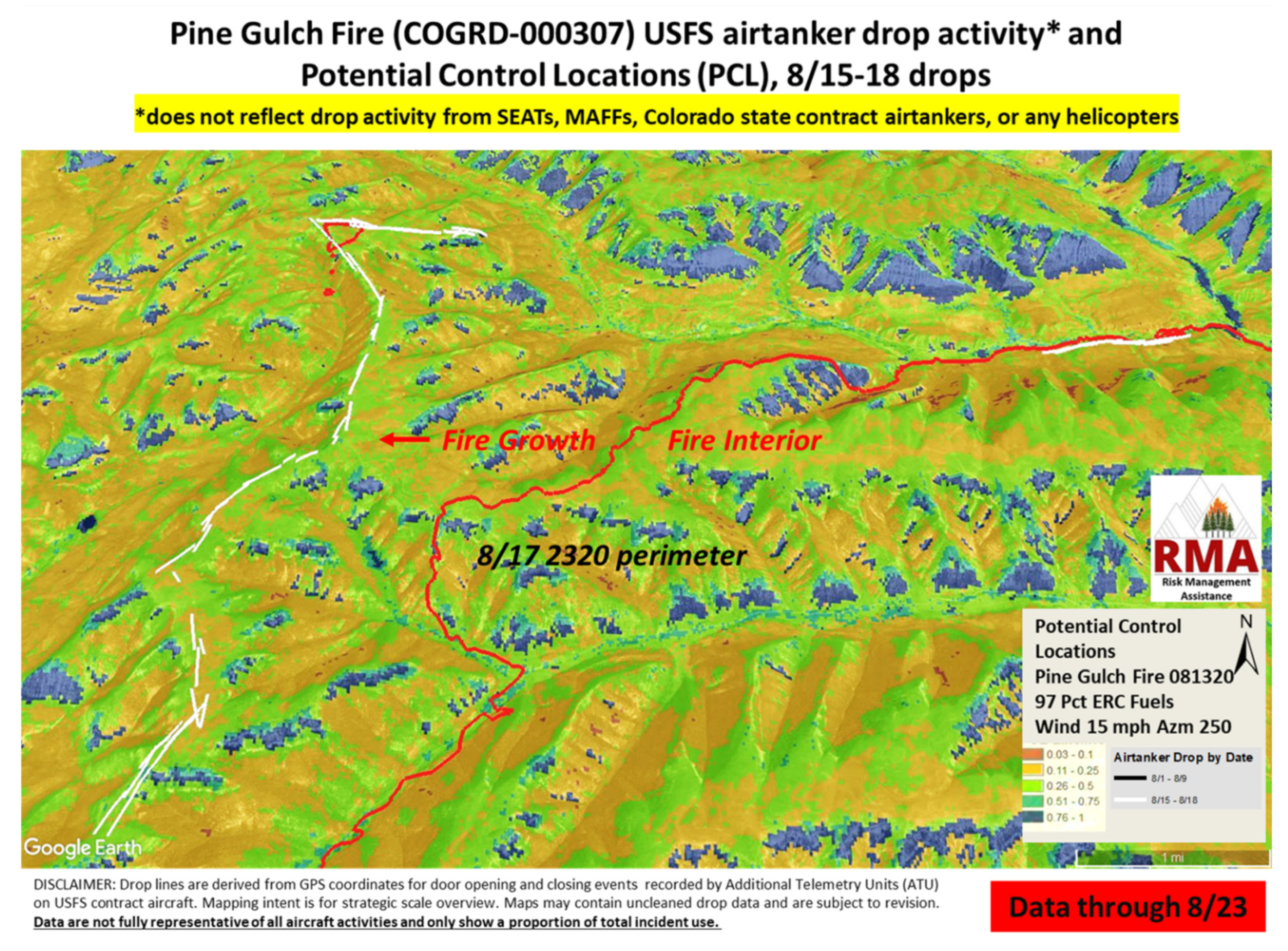
2.2. Summarizing and Mapping Aircraft Drops

The ability to track the location of suppression resource actions in near real-time can improve RIDM. Avionics (electronic aircraft equipment) that log flight paths and drop events are commonplace on modern aircraft [54]; thus, aviation activity can be tracked for most federally owned and contracted aircraft. The USFS has an avionics contract requirement for large airtankers that specifies functionality of Additional Telemetry Unit (ATU) sensors to log the location of door events coincident with airtanker drop locations. ATUs are a more recent requirement for large and medium helicopters on exclusive use contracts, but these systems do not yet provide consistent program-wide data and are therefore not routinely utilized in AUS products. ATUs log fill events, as well as door events (open and close), and these points are linked to key flight and delivery parameters (e.g., airspeed, altitude, heading, and gallons delivered). Door open/close data points allow creation of drop lines within GIS. ATU drop event data collection is automated, and data are available in near real-time. However, different aviation contractors utilize different data management and reporting structures, currently limiting full automation. “Near real-time” in the context of the current RMA work generally encompasses all activity up through the previous operational period (prior day) to allow time for manual data collection, compilation, and display.
Figure 5 provides an example map and summary table from the Grizzly Creek Fire from Colorado in 2020. In Figure 5, we see cumulative aircraft use for the first week of a large fire (~10,000 ha at the time of the report) with daily airtanker engagement summarizing drops per day and aircraft type. This is supported by a narrative summary highlighting key points of interest and describing the level of completeness of the data. The ATU data system is not currently interagency, and data are not available for aircraft owned or contracted by entities other than the USFS. Therefore, communication of missing information in the activity summary table can be highly valuable (inferred from the Resource Assignment Timeline).
ATU-mapped drop events are particularly interesting and useful when they are tied to data that characterize the operational conditions and physical landscape when and where drops occur. These data typically consist of key landscape features (e.g., terrain, roads, cities, hydrography, jurisdictional boundaries) and information on the fire’s location. Ideally, daily fire perimeters can be shown alongside coincident drop lines to indicate proximity of drop events to the fire. Many other datasets can be incorporated to increase the effectiveness of mapped drop lines as a decision support and communication tool. Figure 6 depicts maps of drop lines for generic unnamed incidents to illustrate examples of different background datasets. Figure 6a shows drops along with Potential Control Locations (PCL; [42]), which are areas on the landscape where fire is most likely to stop (depicted in the figure as cool colors). In this example, drops are well aligned with high probability PCL zones within a broader area of limited opportunities to stop fire growth. PCL could be utilized prior to aviation actions to pre-identify locations where suppression actions are most likely to succeed. Figure 6b depicts another series of drops relative to the Suppression Difficulty Index (SDI; [55,56]). SDI illustrates where on the landscape it is safe (or possible) for ground firefighters to engage. When coupled with drop locations, it can highlight drops that could or could not be well supported by ground forces. This tool may be particularly useful to communicate decisions to minimize mid-slope or minor ridgeline drops that have potential limited effectiveness and are likely unsupported by ground forces. Figure 6c illustrates drops along with a map of fire progression. Given the range of potential drop objectives, illustrated interior drops may be intentional delay actions. Other geospatial products that have been coupled with ATU data to create AUS maps include fire spread probability model outputs, built structures, other values at risk, retardant avoidance areas (terrestrial and aquatic), fire history data, and potential adjacent drop activity from recent fires. Documenting the location and conditions of drop locations can facilitate tactical and strategic alignment across the different roles outlined in Figure 2.

2.3. Drop Condition Matrix

The Drop Condition Matrix informs dialogue about relative potential effectiveness of aircraft actions given the timing and environmental conditions coincident with drops. Stonesifer et al. [27] illustrated methods to indicate potential drop effectiveness from automated drop records, identifying the proportion of incident drops by majority fuel type, slope class, and time of day as a coarse proxy for potential wildfire behavior. With the assumption that steeper slopes, denser canopies, and periods of active fire behavior all potentially limit retardant effectiveness, this tool can guide tactical actions toward conditions with greater potential effectiveness (e.g., earlier in the day) or a disengagement of use under certain conditions. Use associated with a particular category does not imply ineffective utilization, but visualization of the drop parameters in this way can highlight patterns of use that may fall outside of best practices. Figure 7a depicts a drop condition matrix for an example fire where most drops occur in the steepest slope category and in timber fuel models. Many (42.2%) occur in late afternoon (1500–1800), coincident with what is likely to be the peak burning period. With the recognition of the potential limitations of utilizing time of day as an indicator of fire behavior, other fire behavior indicators can be used if available. For example, the Severe Fire Danger Index (SFDI) [57], which utilizes historical climatology and fire intensity and spread indices to forecast extreme fire danger days, has also been employed in limited exploration to populate the proportion of drops under different slope, fuel, and fire danger conditions. An example Drop Condition Matrix is depicted in Figure 7b, where drops for a regional analysis are summarized. This example indicates broader allocation of drops by fuel type and slope steepness categories, but 48.9% of all drops occurred in the two highest SFDI categories (Very High and Severe).

2.4. Illustrative Use Case

As the data and related products have been socialized, certain early adopters have embraced the AUS as a critical decision-making and communication tool. The Rocky Mountain Type 1 IMT, led by IC Dan Dallas, is one such early adopter. His team has utilized AUS to support decisions on multiple fires. A recent incident where AUS helped guide decisions regarding the level of airtanker use was on the Pine Gulch Fire in Colorado, which was ignited by lightning in drought-stressed timber on 31 July 2020. For more information and background on this incident, please refer to the public information available at InciWeb: https://inciweb.nwcg.gov/incident/6906/ (accessed on 21 May 2021). According to personal communications with Dallas (28 April 2021 email), on 14 August 2020, the Rocky Mountain Type 1 IMT assumed command of the roughly 30,000 ha wildfire burning on federal lands 29 km from Grand Junction, population 65,000, and location of an airtanker base. The AUS was requested prior to the IMT’s arrival and documented all airtanker use preceding the IMT’s assignment (52 cumulative drop events since 31 July 2020, which were all interior to the fire’s current footprint). The fire had received heavy initial attack activity that extended into large fire support under management of a Type 2 IMT working to contain the fire as small as possible. Upon assuming command, the Type 1 IMT utilized the AUS maps along with ground-based intelligence to determine that current fuel conditions were not conducive to effective retardant use. Retardant use was halted until such time as to be necessary to protect future built holding lines. Data and maps from the AUS directly helped minimize ineffective retardant drops for a high visibility (close to a city and freeway), high profile wildfire (it became the largest fire in Colorado state history at the time), very near to an established airtanker base. Sociopolitical pressures to utilize air support under these high visibility circumstances can influence IMTs to more heavily employ aircraft than they may otherwise [58]. The AUS provided a communications tool for limiting airtanker use in line with the incident’s strategic objectives.
Nine days later, the Rocky Mountain Type 1 IMT ordered a second AUS to map extensive drop activity supporting a line building campaign along what the IC called the “Last Best Shot (Figure 8)”. Potential Control Location (PCL) data were used to help identify the landscape features with the highest likelihood of containment in an extremely challenging landscape with few potential holding features. This line represented the only retardant use during the IMT’s 19-day tenure on this incident. While this line was ultimately breached due to an unusual and isolated thunderstorm related wind event, the application of the AUS allowed for richer dialog around aviation strategies and for a defensible, documentable RIDM process [59].

3. Discussion

3.1. Current Use of AUS

AUS has informed discussions about the appropriate level of aviation use consistent with strategic objectives, highlighting escalating trends in aircraft assignments in large fire support, and facilitated discussions regarding cumulative exposure from long duration aircraft assignments [60]. A well-designed and managed geospatial data collection and reporting system that tracks aircraft movement and events is a foundational requirement to effective and efficient aircraft operations under an RIDM structure. ATU tracking data provide near real-time intelligence and an archived repository, both of which contribute to strategic alignment, learning opportunities, and accountability.
Ongoing RMA work has demonstrated the value of the AUS in multiple capacities. In the fire management environment, drop data and use summaries help establish a common operating picture, provide a visual tool to help manage tactical and strategic risk, and facilitate decisions to reduce use during conditions of limited effectiveness (e.g., Pine Gulch Fire). The AUS is a critical communications tool to capture drop activity that has occurred relative to objectives, values at risk, fire progression, opportunities for containment, and modeled fire growth. For example, in 2018, AUS products supported Regional Forester discussions regarding aviation costs and exposure amid high-demand fire activity and resource scarcity in the Pacific Northwest Region. On the Grizzly Fire from 2020, AUS drop line data and maps provided near real-time understanding of how retardant drops related to ground operations, including dozer lines, hand lines, and natural features. This allowed the IMT to shape the tactical plan of operations for the current shift based on what had taken place the previous day. Additionally, on the Horse Fire on the Prescott National Forest from 2020, these data helped the Forest Supervisor discuss risk with the IMT and supported follow up discussions with partner agencies regarding cost-share agreements.
At the programmatic level, these data could facilitate informed fleet planning decisions and provide more streamlined usage reporting and summaries to meet national reporting mandates. Furthermore, ATU data add value through improved efficiency and accuracy in the tracking of retardant application on identified avoidance areas, including habitat for certain protected wildlife species, cultural resources, and in waterways on national forest lands [61]. Retardant chemicals can degrade habitat and irreparably damage sensitive cultural resources [62]. ATU data enhance the agency’s ability to track retardant misapplication in post-fire environments, ensuring accountability of use, and minimizing post-fire exposure to personnel tasked with locating and mitigating the environmental effects of retardant drops.
Expansion of the utilization of the AUS will require a shift in the temporal decision space so that the AUS is utilized more frequently as a forward-looking planning tool versus a backward-looking accountability tool. A structured decision-making process to facilitate and document a check-in and planning dialogue that utilizes key AUS data (ATU drop records and resource assignment summaries) can help ensure that ongoing use aligns with incident strategy and leader’s intent. Figure 9 depicts a prototype aviation check-in form. This prototype form is meant to coincide with the incident planning cycle, which may be daily or every few days, depending on the incident. It is designed with two key sections: log and plan. With automated ATU data widely available for all drop activities, incidents could readily use this information to facilitate informed discussions between the IC and Operations. The objective would be to discuss previous and ongoing actions, assess effectiveness, and use this information to formulate the plan. The IC then signs off on the plan which brings the scale of the decision in alignment with the authority of the decision maker. The AA(s) could also provide a review if they are particularly engaged or if there is an extensive air component for a specific fire. This could be especially valuable for fires burning across multiple land ownerships and jurisdictions and fires with multiple complex goals. This process does not usurp the ICS structure because it does not eliminate the tactical flexibility of operators. Conditions may change, and actions may well be warranted and executed that are outside of this plan. However, agreement about a general course of action and scale of aviation use given anticipated conditions and a well-defined incident strategy clearly brings feedback and learning into the decision-making process. It also introduces heightened accountability for making sure that tactical operators understand and are executing the strategy.
Because the fire strategy is often based upon predetermined land management plans (e.g., “Forest Plans” for land managed by the USFS), bringing airtankers into broader alignment with strategy of the fire may also ensure that airtanker use on specific fire fronts is appropriate given the overarching goal for that area of the forest. For example, while an airtanker drop may be appropriate on a fire front with heavy potential losses (e.g., timber production or WUI), it may not be appropriate on another front on the same fire (e.g., wildland areas or wildlife habitat that may benefit from fire).

3.2. Extensions of AUS Data and Products

Beyond accountability, AUS and underlying ATU event tracking data can improve and inform pre-season and active incident dialogue and planning with partner agencies regarding tactics for limiting fire transmission across boundaries. Because jurisdictional boundaries are not necessarily aligned with landscape features conducive to stopping fire spread, retardant use in these locations may have limited effectiveness. Cross-boundary planning and Potential Operational Delineation (POD) work can help identify those key suppression opportunities that help neighboring landowners meet suppression mandates and achieve land management objectives [43,44,48]. ATU data coupled with PODs, PCL, and SDI can inform discussions about higher likelihood containment opportunities that may exist beyond ownership boundaries. To provide one real-world example, the Rogue River Basin in southwestern Oregon is a mixed ownership landscape with a complex set of land management objectives and highly valued resources and assets including timber, wildlife habitat, municipal water supplies, and human communities, where suitable fire containment opportunities are limited and rarely align with ownership boundaries (see Figure 5 in [43]), and where recent efforts have sought to assess risk, prioritize mitigation, and plan for fire response across these boundaries [63]. The Klondike Fire on the Rogue-Siskiyou National Forest in 2018 requested RMA support, including an AUS. This large fire was challenged by the issues previously discussed, in addition to resource scarcity and concurrent large fire demand, both regionally and nationally. For situations like these, the AUS enables richer conversations to help collectively identify locations and conditions under which aerial suppression actions would be necessary. Combined with real-time AUS data, incident management teams would have better information and context to guide safer and more effective aerial suppression.
Moving to broader strategic scales, decision support to inform which fires receive aerial resources is crucial when considering risk-informed aviation use. Given the limited number of aviation assets, some resource requests go unfilled each year [17]. Resource assignment decisions are outside of the control of the individual IMTs because nationally available aircraft assignments are controlled by Geographic Area Coordination Centers (https://gacc.nifc.gov (accessed on 21 July 2021)) or the National Interagency Coordination Center (NICC). During periods of simultaneous fire activity, national and geographic multiagency coordinating (MAC) groups are brought together to prioritize the allocation of firefighting resources to ongoing fires. The national MAC group (NMAC) is responsible for prioritizing and facilitating assignments of national assets (including airtankers) and the movements of resources between geographic areas, while the geographic area MAC groups (GMACs) are responsible for assigning resources within their geographic area (including those allocated to them by NICC) to specific fires. Historical ATU data could help inform which fires are likely to see higher levels of success based upon a fire’s profile (e.g., expected short term fire behavior, topography, and fire strategy). Real-time ATU data could provide MAC groups with information regarding ongoing use of aircraft and would allow MAC groups to shift aircraft between fires and geographic areas as opportunities arise.
In addition to daily regional and national allocation decisions, ATU data may also be valuable for strategic annual decisions. For example, accurate characterization of use and demand is a prerequisite for informed fleet planning. Collection of national scale ATU data and summarization of large fires through AUS analytics will allow the USFS to better understand effectiveness informing fleet planning models. A fleet designed to be in the business of rapid initial attack is potentially configured quite differently than a fleet designed to also provide substantial large fire support.

3.3. Future Utilization and Needs

Although enhanced system accountability is a critical step toward increased effectiveness and efficiency in fire management, there are potential organizational and cultural roadblocks. Changing patterns of behavior can be difficult, especially where there is a cultural bias for action requiring attention to how information is framed and delivered [64]. Similarly, attention will need to be paid to communicating how enhanced monitoring and analysis are intended to support organizational learning and improved performance, rather than second guessing or criticizing the practitioner’s expertise [41]. Some pushback and discomfort are understandable, as broader implementation may create new requirements and oversight responsibilities. Fire managers utilize their experiences to target engagement in those places where actions can be most effective and where risks are commensurate with values protected; it is our intention that AUS can enhance experiential knowledge and improve use decisions [65].

4. Conclusions

Aviation use incurs significant cost and risk in fire suppression in the US, and there is substantial opportunity for enhanced monitoring, performance measurement, and decision support. In this paper we presented and reviewed the AUS, an emerging tool that has seen increasing adoption on large, complex wildfire incidents in the US. We demonstrated the various analytical components of the AUS (e.g., resource timeline, summary maps), provided interpretation, and illustrated through a case study how results can lead to shifts in response strategies and tactics. Lastly, we identified future areas for improvement. Through this work, we demonstrate that shifting “Is this flight necessary?” to “How does this flight support the strategy?” with analytical insight can inform the overall approach to data-driven accountability and RIDM for aviation use in wildfire suppression.

Author Contributions

Conceptualization, C.S.S. and D.E.C.; methodology, C.S.S.; formal analysis, C.S.S.; investigation, C.S.S. and E.J.B.; data curation, C.S.S. and E.J.B.; writing—original draft preparation, C.S.S., D.E.C.; writing—review and editing, M.P.T. and E.J.B.; visualization, C.S.S.; supervision, D.E.C.; project administration, C.S.S.; funding acquisition, D.E.C. All authors have read and agreed to the published version of the manuscript.

Funding

This research was supported by the U.S. Department of Agriculture, Forest Service.

Data Availability Statement

The data presented in this study are available on request from the corresponding author.

Conflicts of Interest

The authors declare no conflict of interest. The findings and conclusions in this report are those of the author(s) and should not be construed to represent any official U.S. Department of Agriculture or U.S. Government determination or policy.

References

  1. National Interagency Fire Center. Wildland Fire Statistics. Available online: https://www.nifc.gov/fireInfo/fireInfo_statistics.html (accessed on 28 July 2021).
  2. Marlon, J.R.; Bartlein, P.J.; Gavin, D.G.; Long, C.J.; Anderson, R.S.; Briles, C.E.; Brown, K.J.; Colombaroli, D.; Hallett, D.J.; Power, M.J.; et al. Long-Term Perspective on Wildfires in the Western USA. Proc. Natl. Acad. Sci. USA 2012, 109, E535–E543. [Google Scholar] [CrossRef] [Green Version]
  3. Moritz, M.A.; Batllori, E.; Bradstock, R.A.; Gill, A.M.; Handmer, J.; Hessburg, P.F.; Leonard, J.; McCaffrey, S.; Odion, D.C.; Schoennagel, T.; et al. Learning to Coexist with Wildfire. Nature 2014, 515, 58–66. [Google Scholar] [CrossRef] [PubMed]
  4. Calkin, D.E.; Thompson, M.P.; Finney, M.A. Negative Consequences of Positive Feedbacks in US Wildfire Management. For. Ecosyst. 2015, 2, 9. [Google Scholar] [CrossRef] [Green Version]
  5. Abatzoglou, J.T.; Williams, A.P. Impact of Anthropogenic Climate Change on Wildfire across Western US Forests. Proc. Natl. Acad. Sci. USA 2016, 113, 11770–11775. [Google Scholar] [CrossRef] [PubMed] [Green Version]
  6. Harvey, B.J. Human-Caused Climate Change Is Now a Key Driver of Forest Fire Activity in the Western United States. Proc. Natl. Acad. Sci. USA 2016, 113, 11649–11650. [Google Scholar] [CrossRef] [PubMed] [Green Version]
  7. Halofsky, J.E.; Peterson, D.L.; Harvey, B.J. Changing Wildfire, Changing Forests: The Effects of Climate Change on Fire Regimes and Vegetation in the Pacific Northwest, USA. Fire Ecol. 2020, 16, 4. [Google Scholar] [CrossRef] [Green Version]
  8. Gergel, D.R.; Nijssen, B.; Abatzoglou, J.T.; Lettenmaier, D.P.; Stumbaugh, M.R. Effects of climate change on snowpack and fire potential in the western USA. Clim. Chang. 2017, 141, 287–299. [Google Scholar] [CrossRef]
  9. Busby, S.U.; Moffett, K.B.; Holz, A. High-Severity and Short-Interval Wildfires Limit Forest Recovery in the Central Cascade Range. Ecosphere 2020, 11, e03247. [Google Scholar] [CrossRef]
  10. Coop, J.D.; Parks, S.A.; Stevens-Rumann, C.S.; Crausbay, S.D.; Higuera, P.E.; Hurteau, M.D.; Tepley, A.; Whitman, E.; Assal, T.; Collins, B.M.; et al. Wildfire-Driven Forest Conversion in Western North American Landscapes. Bioscience 2020, 70, 659–673. [Google Scholar] [CrossRef] [PubMed]
  11. National Interagency Fire Center. Federal Firefighting Costs (Suppression Only). Available online: https://www.nifc.gov/fireInfo/fireInfo_documents/SuppCosts.pdf (accessed on 28 July 2021).
  12. USDA Forest Service. The Rising Cost of Fire Operations: Effects on the Forest Service’s Non-Fire Work. 2014. Available online: https://www.fs.usda.gov/sites/default/files/2015-Fire-Budget-Report.pdf (accessed on 28 July 2021).
  13. USDA Forest Service. People Working in Fire. Available online: https://www.fs.usda.gov/science-technology/fire/people (accessed on 21 May 2021).
  14. USDA Forest Service Fire and Aviation Management. Aviation Annual Report. 2018. Available online: https://www.fs.usda.gov/sites/default/files/2019-07/cy2018_usfs_aviation_report_final_20190702.pdf (accessed on 21 May 2021).
  15. Jarvis, A. Study on Wild Fire Fighting Resources Sharing Models—Final Report; European Policy Evaluation Consortium: Brussels, Belgium, 2010. [Google Scholar]
  16. Calkin, D.E.; Stonesifer, C.S.; Thompson, M.P.; McHugh, C.W. Large Airtanker Use and Outcomes in Suppressing Wildland Fires in the United States. Int. J. Wildl. Fire 2014, 23, 259–271. [Google Scholar] [CrossRef]
  17. Belval, E.J.; Stonesifer, C.S.; Calkin, D.E. Fire Suppression Resource Scarcity: Current Metrics and Future Performance Indicators. Forests 2020, 11, 217. [Google Scholar] [CrossRef] [Green Version]
  18. USDA Forest Service. Standards for Airtanker Operations. 2019. Available online: https://www.fs.usda.gov/sites/default/files/2019-09/standards_for_airtanker_operations_-_final_-_2019_approved_0.pdf (accessed on 21 May 2021).
  19. Hanks, R. Implementing Management Systems for Aviation Safety. Fire Manag. Today 2011, 71, 28–32. [Google Scholar]
  20. Lane, V.R.; Cordell, K.C.; Zarnoch, S.J.; Green, G.T.; Poudyal, N.; Fox, S. The Forest Service Safety Survey: Results from an Employee-Wide Safety Attitude Survey; Gen. Tech. Rep. SRS-GTR-191; USDA Forest Service, Southern Research Station: Ashville, NC, USA, 2014; 58p. [CrossRef]
  21. Wildland Fire Lessons Learned Center. Annual Incident Review Summaries. Available online: https://www.wildfirelessons.net/viewdocument/annual-incident-review-summaries (accessed on 21 May 2021).
  22. US Government Accountability Office. Wildland Fire Management: Improvements Needed in Information, Collaboration, and Planning to Enhance Federal Fire Aviation Program Success; GAO-13-684; US Government Accountability Office: Washington, DC, USA, 2013; 55p.
  23. Booz Allen Hamilton. 2014 Quadrennial Fire Review: Final Report. 2015. Available online: https://www.forestsandrangelands.gov/documents/qfr/2014QFRFinalReport.pdf (accessed on 21 May 2021).
  24. USDA Forest Service; US Department of Interior. National Study of Airtankers to Support Initial Attack and Large Fire Suppression: Final Report Phase 1. 1995. Available online: https://www.fs.usda.gov/sites/default/files/media_wysiwyg/nats1_main_body-report.pdf (accessed on 21 May 2021).
  25. Keating, E.G.; Morral, A.R.; Price, C.C.; Woods, D.; Norton, D.M.; Panis, C.; Saltzman, E.; Sanchez, R. Air Attack against Wildfires: Understanding US Forest Service Requirements for Large Aircraft. 2012. Available online: https://www.rand.org/content/dam/rand/pubs/monographs/2012/RAND_MG1234.pdf (accessed on 21 May 2021).
  26. Thompson, M.P.; Calkin, D.E.; Herynk, J.; McHugh, C.W.; Short, K.C. Airtankers and Wildfire Management in the US Forest Service: Examining Data Availability and Exploring Usage and Cost Trends. Int. J. Wildl. Fire 2013, 22, 223. [Google Scholar] [CrossRef]
  27. Stonesifer, C.S.; Calkin, D.E.; Thompson, M.P.; Stockmann, K.D. Fighting Fire in the Heat of the Day: An Analysis of Operational and Environmental Conditions of Use for Large Airtankers in United States Fire Suppression. Int. J. Wildl. Fire 2016, 25, 520–533. [Google Scholar] [CrossRef]
  28. Interagency Airtanker Board. 2013 Procedures and Criteria. 2013. Available online: https://www.nwcg.gov/sites/default/files/committee/docs/iab-procedures-criteria.pdf (accessed on 21 May 2021).
  29. National Wildfire Coordinating Group. NWCG Standards for Aerial Supervision. PMS-505. NFES-002544; 2020. Available online: https://www.nwcg.gov/sites/default/files/publications/pms505.pdf (accessed on 21 May 2021).
  30. USDA Forest Service. Aerial Firefighting Use and Effectiveness (AFUE) Report. 2020. Available online: https://www.fs.usda.gov/sites/default/files/2020-08/08242020_afue_final_report.pdf (accessed on 21 May 2021).
  31. Plucinski, M.P.; Pastor, E. Criteria and Methodology for Evaluating Aerial Wildfire Suppression. Int. J. Wildl. Fire 2013, 22, 1144–1154. [Google Scholar] [CrossRef]
  32. Thompson, M.P.; Macgregor, D.G.; Calkin, D.E. Risk Management: Core Principles and Practices, and Their Relevance to Wildland Fire; Gen. Tech. Rep. RMRS-GTR-350; USDA Forest Service, Rocky Mountain Research Station: Fort Collins, CO, USA, 2016; 29p. [CrossRef]
  33. International Organization for Standardization. ISO—ISO 31000:2018—Risk Management—Guidelines. Available online: https://www.iso.org/standard/65694.html (accessed on 21 May 2021).
  34. Thompson, M.P.; Marcot, B.G.; Thompson, F.R.; McNulty, S.; Fisher, L.A.; Runge, M.C.; Cleaves, D.; Tomosy, M. The Science of Decisionmaking: Applications for Sustainable Forest and Grassland Management in the National Forest System; Gen. Tech. Rep. WO-GTR-88; USDA Forest Service: Washington, DC, USA, 2013; 54p. [CrossRef] [Green Version]
  35. Schultz, C.A.; Miller, L.F.; Greiner, S.M.; Kooistra, C. A Qualitative Study on the Us Forest Service’s Risk Management Assistance Efforts to Improve Wildfire Decision-Making. Forests 2021, 12, 344. [Google Scholar] [CrossRef]
  36. Marcot, B.G.; Thompson, M.P.; Runge, M.C.; Thompson, F.R.; McNulty, S.; Cleaves, D.; Tomosy, M.; Fisher, L.A.; Bliss, A. Recent Advances in Applying Decision Science to Managing National Forests. For. Ecol. Manag. 2012, 285, 123–132. [Google Scholar] [CrossRef]
  37. Stratton, R.D. The Path to Strategic Wildland Fire Management Planning. Wildfire 2020, 29, 24–31. [Google Scholar]
  38. Hunter, M.E.; Colavito, M.M.; Wright, V. The Use of Science in Wildland Fire Management: A Review of Barriers and Facilitators. Curr. For. Rep. 2020, 6, 354–367. [Google Scholar] [CrossRef]
  39. Colavito, M. The Human Dimensions of Spatial, Pre-Wildfire Planning Decision Support Systems: A Review of Barriers, Facilitators, and Recommendations. Forests 2021, 12, 483. [Google Scholar] [CrossRef]
  40. Taber, M.A.; Elenz, L.M.; Langowski, P.G. Decision Making for Wildfires: A Guide for Applying a Risk Management Process at the Incident Level; Gen. Tech. Rep. RMRS-GTR-298; US Department of Agriculture, Forest Service, Rocky Mountain Research Station: Fort Collins, CO, USA, 2013; 59p. [CrossRef] [Green Version]
  41. Thompson, M.P.; Wei, Y.; Calkin, D.E.; O’Connor, C.D.; Dunn, C.J.; Anderson, N.M.; Hogland, J.S. Risk Management and Analytics in Wildfire Response. Curr. For. Rep. 2019, 5, 226–239. [Google Scholar] [CrossRef] [Green Version]
  42. O’Connor, C.D.; Calkin, D.E.; Thompson, M.P. An Empirical Machine Learning Method for Predicting Potential Fire Control Locations for Pre-Fire Planning and Operational Fire Management. Int. J. Wildl. Fire 2017, 26, 587–597. [Google Scholar] [CrossRef]
  43. Dunn, C.J.; O’Connor, C.D.; Abrams, J.; Thompson, M.P.; Calkin, D.E.; Johnston, J.D.; Stratton, R.; Gilbertson-Day, J. Wildfire Risk Science Facilitates Adaptation of Fire-Prone Social-Ecological Systems to the New Fire Reality. Environ. Res. Lett. 2020, 15, 025001. [Google Scholar] [CrossRef]
  44. Thompson, M.P.; Bowden, P.; Brough, A.; Scott, J.H.; Gilbertson-Day, J.; Taylor, A.; Anderson, J.; Haas, J.R.; Verbyla, D.; Martin, T.A. Application of Wildfire Risk Assessment Results to Wildfire Response Planning in the Southern Sierra Nevada, California, USA. Forests 2016, 7, 64. [Google Scholar] [CrossRef]
  45. National Wildfire Coordinating Group. NWCG Standards for Airtanker Base Operations. PMS-508. 2020. Available online: https://www.nwcg.gov/sites/default/files/publications/pms508.pdf (accessed on 21 May 2021).
  46. National Wildfire Coordinating Group. NWCG Standards for Helicopter Operations. PMS-510. 2019. Available online: https://www.nwcg.gov/sites/default/files/publications/pms510.pdf (accessed on 21 May 2021).
  47. Washington State Department of Natural Resources. Aviation Operating Plan and Standards (AOPS). 2017. Available online: https://www.dnr.wa.gov/publications/rp_fire_aviation_operations_plan.pdf (accessed on 21 May 2021).
  48. O’Connor, C.D.; Thompson, M.P.; Rodríguez y Silva, F. Getting Ahead of the Wildfire Problem: Quantifying and Mapping Management Challenges and Opportunities. Geosciences 2016, 6, 35. [Google Scholar] [CrossRef] [Green Version]
  49. USDA Forest Service. Forest Service Manual, FSM 1200—Organization. Chapter 1230—Delegations of Authority and Responsibility; 2020. Available online: https://www.fs.fed.us/cgi-bin/Directives/get_dirs/fsm?1200 (accessed on 21 May 2021).
  50. Alperen, M.J. National Incident Management System (NIMS). In Foundations of Homeland Security: Law and Policy; John Wiley & Sons, Inc.: Hoboken, NJ, USA, 2011. [Google Scholar] [CrossRef]
  51. USDA Forest Service. Forest Service Manual, FSM 5100—Wildland Fire Management; Chapter 5130—Wildfire Response. 2017. Available online: https://www.fs.fed.us/cgi-bin/Directives/get_dirs/fsm?5100 (accessed on 21 May 2021).
  52. Nowell, B.; Steelman, T. Communication under Fire: The Role of Embeddedness in the Emergence and Efficacy of Disaster Response Communication Networks. J. Public Adm. Res. Theory 2015, 25, 929–952. [Google Scholar] [CrossRef]
  53. USDA Forest Service Fire and Aviation Management. 2019 Aviation SMS Guide. Available online: https://www.fs.usda.gov/sites/default/files/2020-08/nasms_guide_2019_final_v._2019-1.0_0.pdf (accessed on 21 May 2021).
  54. Collinson, R.P.G. Role of avionics in modern aircraft. Electron. Power 1978, 24, 280–284. [Google Scholar] [CrossRef]
  55. Rodríguez y Silva, F.A.; Martínez, J.R.M.; González-Cabán, A.B. A Methodology for Determining Operational Priorities for Prevention and Suppression of Wildland Fires. Int. J. Wildl. Fire 2014, 23, 544–554. [Google Scholar] [CrossRef]
  56. Rodríguez y Silva, F.A.; O’Connor, C.D.; Thompson, M.P.; Martínez, J.R.M.; Calkin, D.E. Modelling Suppression Difficulty: Current and Future Applications. Int. J. Wildl. Fire 2020, 29, 739–751. [Google Scholar] [CrossRef]
  57. Jolly, W.M.; Freeborn, P.H.; Page, W.G.; Butler, B.W. Severe Fire Danger Index: A Forecastable Metric to Inform Firefighter and Community Wildfire Risk Management. Fire 2019, 2, 47. [Google Scholar] [CrossRef] [Green Version]
  58. Canton-Thompson, J.; Gebert, K.M.; Thompson, B.; Jones, G.; Calkin, D.; Donovan, G. External Human Factors in Incident Management Team Decisionmaking and Their Effect on Large Fire Suppression Expenditures. J. For. 2008, 106, 416–424. [Google Scholar]
  59. NASA. NASA Risk-Informed Decision Making Handbook. NASA/SP-2010-576. Available online: https://ntrs.nasa.gov/citations/20100021361 (accessed on 21 May 2021).
  60. Stonesifer, C.S.; Calkin, D.E.; Thompson, M.P.; Kaiden, J.D. Developing an Aviation Exposure Index to Inform Risk-Based Fire Management Decisions. J. For. 2014, 112, 581–590. [Google Scholar] [CrossRef]
  61. USDA Forest Service Fire and Aviation Management. Implementation Guide for Aerial Application of Fire Retardant. 2019. Available online: https://www.fs.usda.gov/sites/default/files/2019-06/2019_afr_imp_guide.pdf (accessed on 21 May 2021).
  62. USDA Forest Service Fire and Aviation Management. Nationwide Aerial Application of Fire Retardant on National Forest System Land, Record of Decision. 2011. Available online: https://www.fs.usda.gov/sites/default/files/media_wysiwyg/wfcs_rod_12_15_11_0.pdf (accessed on 21 May 2021).
  63. Metlen, K.L.; Fairbanks, T.; Bennett, M.; Volpe, J.; Kuhn, W.; Thompson, M.P.; Thrailkill, J.; Schindel, M.; Helmbrecht, D.; Scott, J.; et al. Integrating Forest Restoration, Adaptation, and Proactive Fire Management: Rogue River Basin Case Study. Can. J. For. Res. 2021, 51, 1–15. [Google Scholar] [CrossRef]
  64. Thompson, M.P.; MacGregor, D.G.; Dunn, C.J.; Calkin, D.E.; Phipps, J. Rethinking the Wildland Fire Management System. J. For. 2018, 116, 382–390. [Google Scholar] [CrossRef] [Green Version]
  65. USDA Forest Service. Leader’s Intent for 2018: A Summary for the Fire Year. 2018. Available online: https://www.fs.usda.gov/features/leaders-intent-2018-summary-fire-year (accessed on 21 May 2021).
Figure 1. US Forest Service (USFS) wildfire suppression expenditures versus aviation costs by fiscal year (1 October through 30 September). Costs are fiscal year totals in 2020 US dollars, adjusted for inflation (CPI; https://www.bls.gov/regions/mid-atlantic/data/consumerpriceindexhistorical_us_table.htm (accessed on 28 July 2021)). USFS expenditures are from the National Interagency Fire Center (NIFC) published report [10]. Airtanker and all aircraft costs are obtained from USFS Aviation Business System (ABS) data and include all Agency costs, not limited to fire suppression. Non-fire costs average less than 5% of total aviation costs annually and are not omitted here due to data limitations and inconsistencies in ABS coding between analysis years.
Forests 12 01078 g001
Figure 2. Key positions and related duties associated with ensuring safe and effective aviation use in fire management. Example questions in the inverted triangle scale the key risk management question “Is this flight necessary?” up to each broader position to examine the interdependence of these duties from tactical, through strategic, and up to enterprise scale.
Forests 12 01078 g002
Figure 3. Flowchart depicting a risk-informed decision-making (RIDM) process that uses land management strategic objectives to inform a wildfire’s management strategy. The RIDM then monitors ongoing actions—in this example, aviation use and effectiveness—through development of the Aviation Use Summary (AUS). This information can help managers ensure the validity of a current strategy given changing conditions and fire growth, and an operational risk assessment informs development of alternative strategies. Examples of the AUS components included in this flowchart (e.g., Resource Assignment Timeline) are each presented later in this manuscript. AA—Agency Administrator; IMT—Incident Management Team; IC—Incident Commander; ROSS—Resource Ordering and Status System; IROC—Inter-agency Resource Ordering and Capability; ATU—Additional Telemetry Unit; IR—infrared; FSPro—Fire Spread Probability.
Forests 12 01078 g003
Figure 4. Resource Assignment Timeline from an Aviation Use Summary (AUS) for the Walker Fire from California in 2019. CAPNF—California Plumas National Forest; ROSS—Resource Ordering and Status System; VLAT—very large airtanker; LAT—large airtanker; T3 ME AT—type 3 multi-engine airtanker, CALFIRE—California Department of Forestry and Fire Protection; SEAT—single engine airtanker; ASM—aerial supervision module; LEAD—leadplane; T1 Heli—type 1 helicopter; T2 Heli—type 2 helicopter; T3 Heli—type 3 helicopter.
Forests 12 01078 g004
Figure 5. Example AUS drop overview map with narrative drop summary and supporting drop count table: Grizzly Creek Fire, Colorado, USA, 10–16 August 2020. LAT—large airtanker; VLAT—very large airtanker; USFS—United States Forest Service; MAFFS—Modular Airborne Firefighting System; Full—full load drop event; Split—split load drop event.
Forests 12 01078 g005
Figure 6. Mapping ATU airtanker drop records with (a) Potential Control Locations (PCL), (b) Suppression Difficulty Index (SDI), and (c) fire progression. LAT—large airtanker; VLAT—very large airtanker.
Forests 12 01078 g006
Figure 7. Drop condition matrix examples. Proportional totals are displayed according to a green to red (low to high) color gradient scale to visually highlight those cells with the highest proportional totals. (a) Proportion of total drop events for an example incident categorized by slope steepness category (by percent slope), majority fuel type (grass, brush, and timber), and time of day as a coarse proxy for potential fire behavior. (b) Proportion of total drop events for a regional scale analysis where drops are categorized by slope steepness, majority fuel type, and Severe Fire Danger Index (SFDI) daily values.
Forests 12 01078 g007
Figure 8. Pine Gulch Fire Aviation Use Summary (AUS) drop location map. Drops are shown as white lines against Potential Control Locations (PCL). The fire perimeter is shown as a red line, measured by infrared flight on 17 August 2020 at 2320 h, local time. For PCL, cool colors represent areas with the highest likelihood of containing the fire. This line of retardant involved 42 drops from 6 different airtankers that supported built line on the ground with roughly 17.4 km and 432,000 L of retardant. COGRD—Colorado Grand Junction Field Office; SEATs—single engine airtankers; MAFFs—Modular Airborne Firefighting Systems; ERC—Energy Release Component; Azm—azimuth.
Forests 12 01078 g008
Figure 9. Prototype Aviation Daily Strategy Check-in tool.
Forests 12 01078 g009
Publisher’s Note: MDPI stays neutral with regard to jurisdictional claims in published maps and institutional affiliations.

