Imaging Buried Archaeological Features through Ground Penetrating Radar: The Case of the Ancient Saepinum (Campobasso, Italy)


Abstract
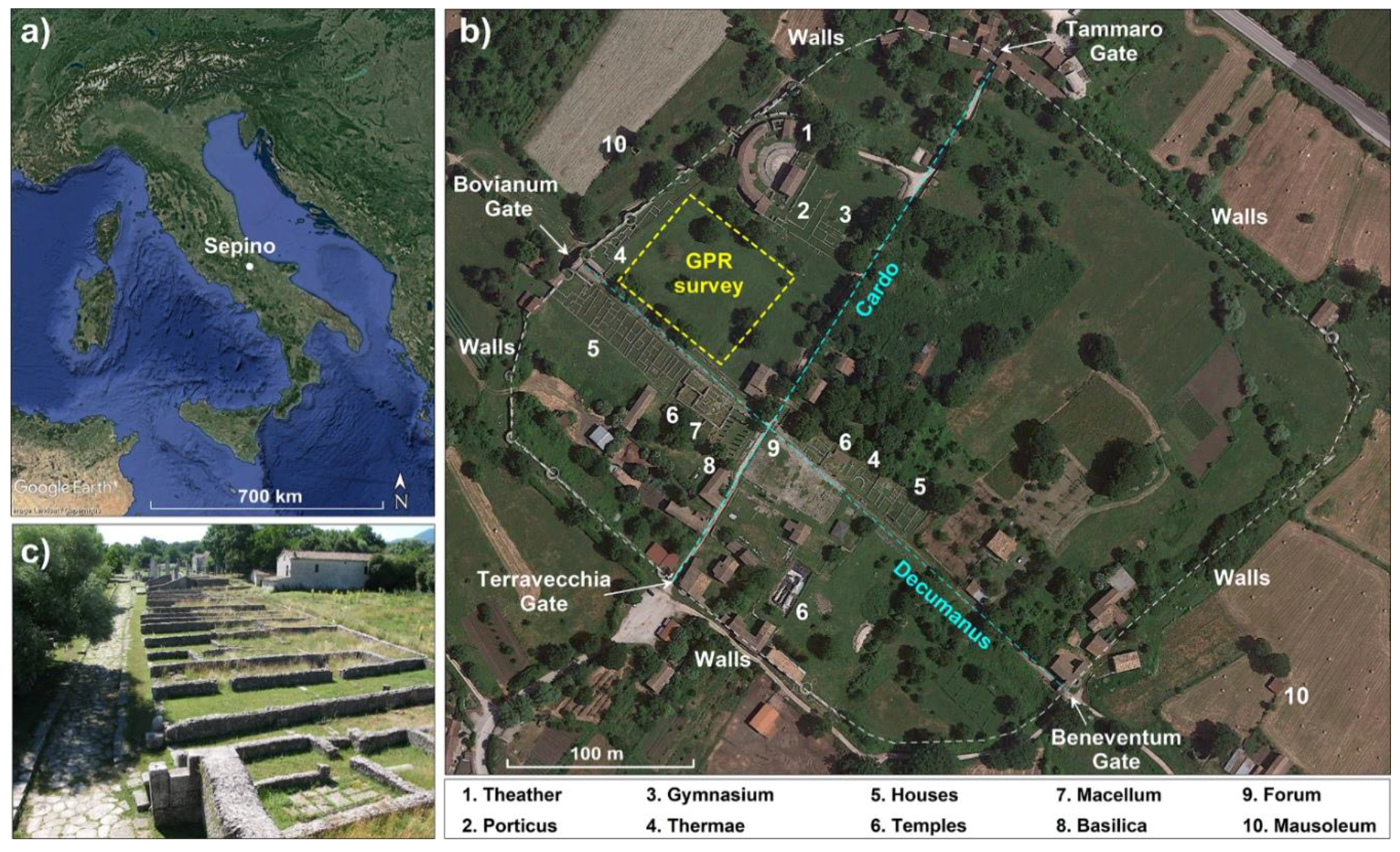
:1. Introduction
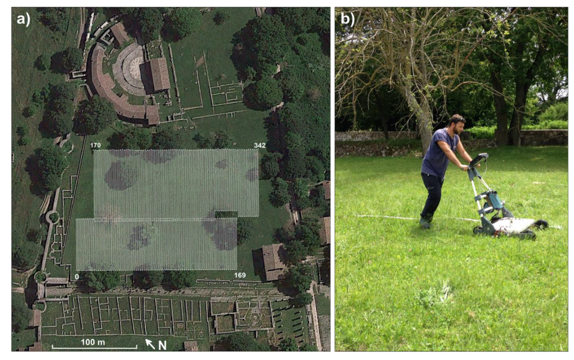
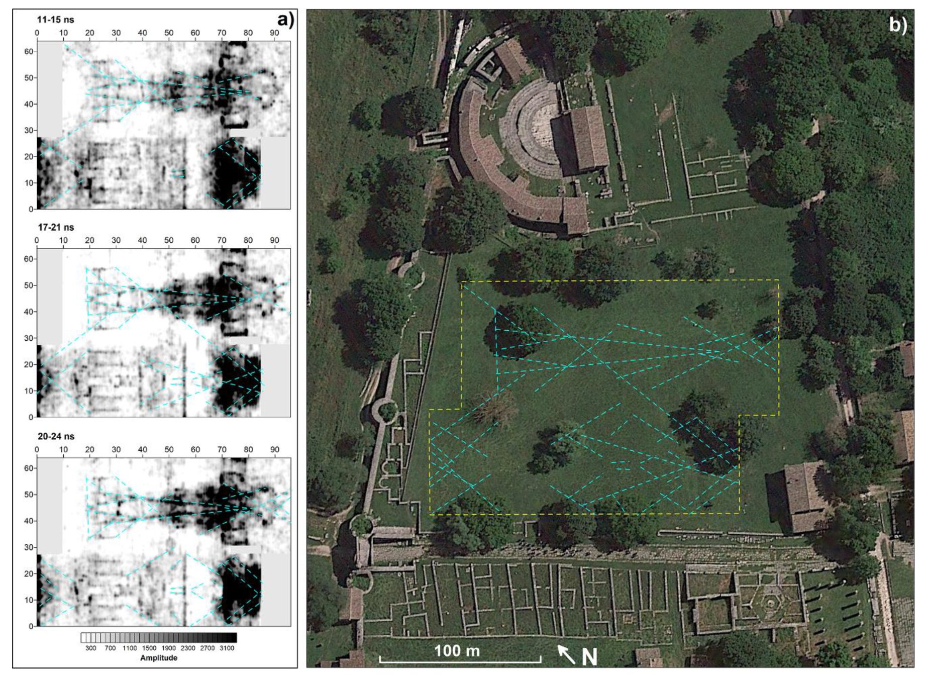
2. Methods, Data Acquisition, and Processing
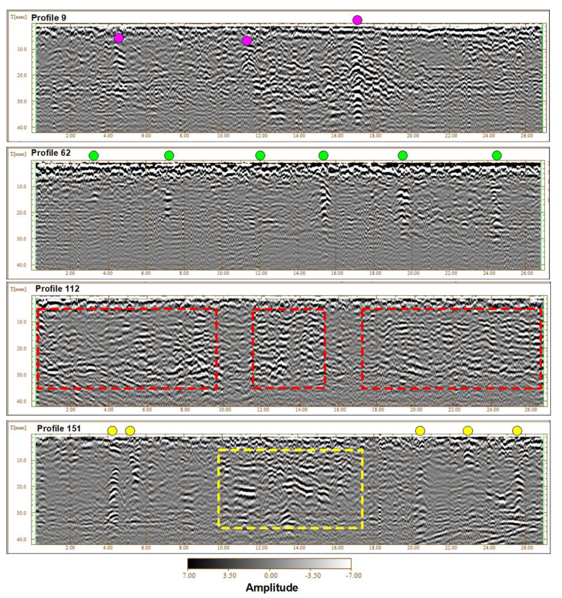
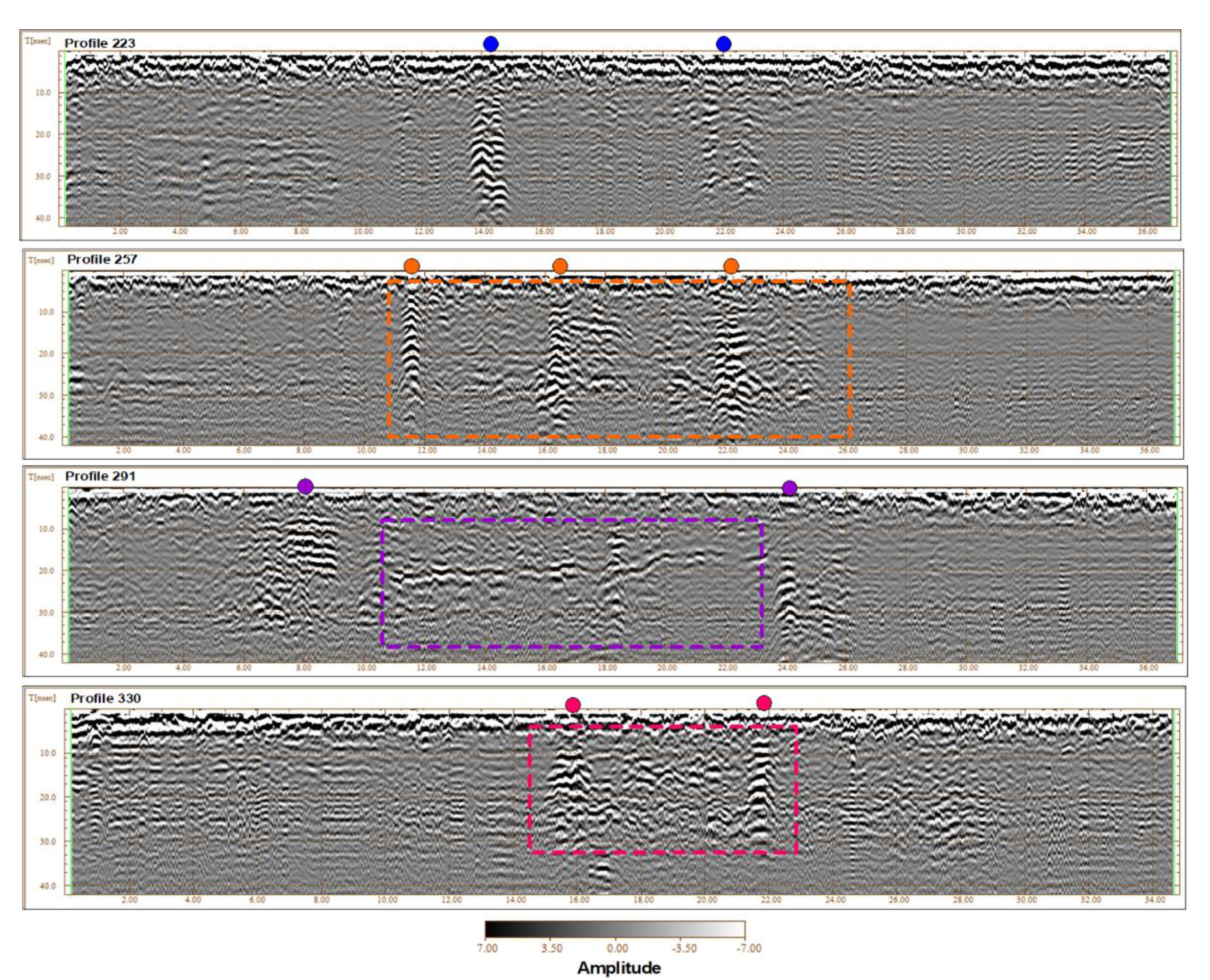
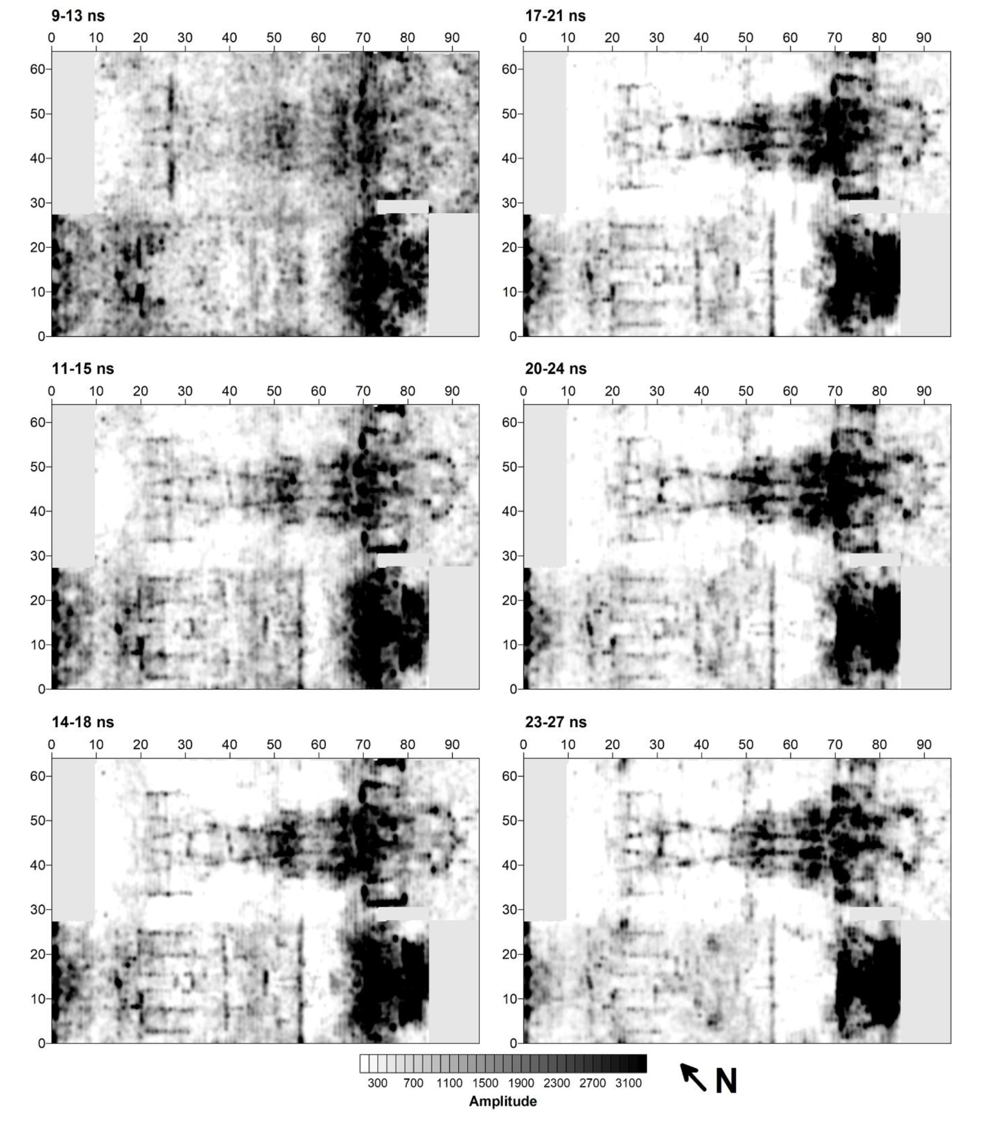
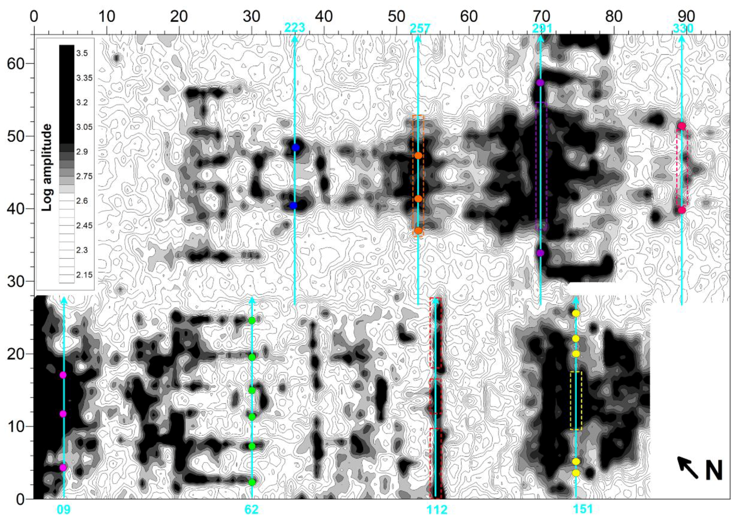
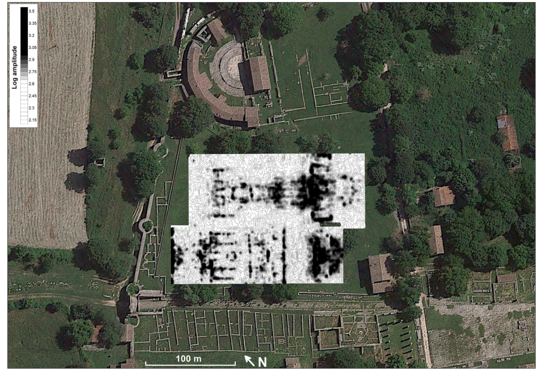
3. Results and Discussion
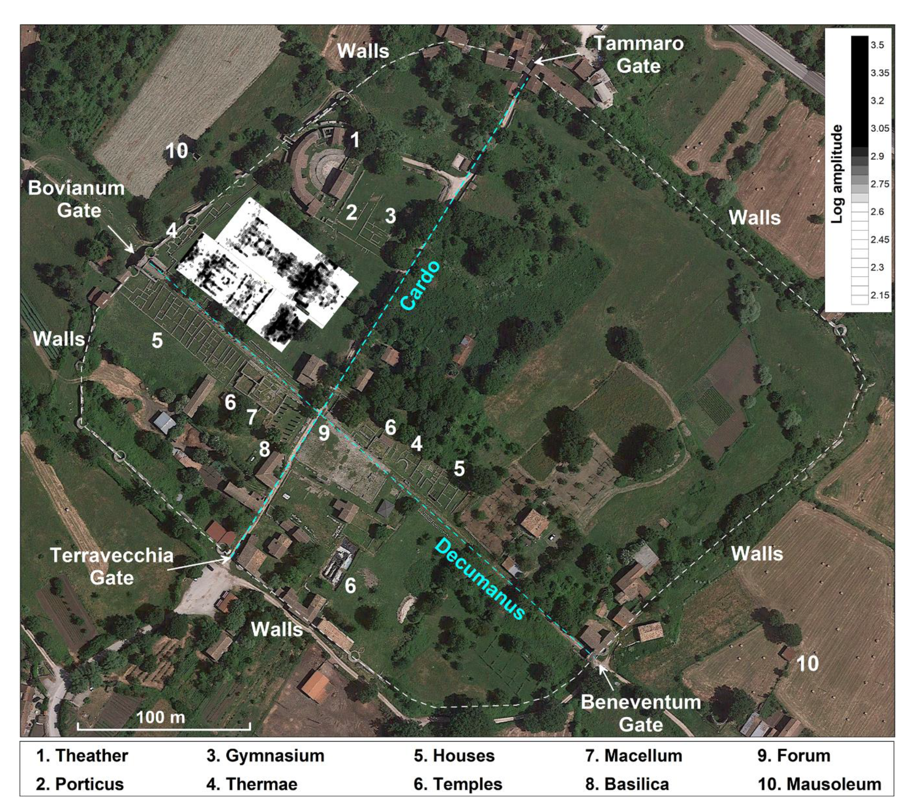
- Three cells (10 in Figure 9) flanked by two single alignments that close orthogonally with two septa;
- A 10 m × 10 m square anomaly (11 in Figure 9);
- Five cells of which the central one is slightly larger and bordered to the north from an open room (12 in Figure 9);
- Regular and symmetrical segments (13 in Figure 9);
- A complex with articulated internal divisions bordered by two large lateral rooms (14 and 15 in Figure 9); and
- A semicircular anomaly of similar dimensions to the previous discussed (16 in Figure 9).
4. Conclusions
Author Contributions
Funding
Acknowledgments
Conflicts of Interest
References
- Valente, E.; Cozzolino, M. GIS mapping of the archaeological sites in the Molise region (Italy). Archeol. Calc. 2019, 30, 367–385. [Google Scholar]
- Oakley, S.P. The Tammaro Valley. In The Hill-Forts of the Samnites; British School at Rome: Rome, Italy, 1995; pp. 69–72. [Google Scholar]
- Titi Livi. Ab Urbe Condita, X, 45, 12; Oxford University Press: Oxford, UK, 1955. [Google Scholar]
- La Regina, A.I. Sanniti. In Italia Omnium Terrarum Parens; Libri Scheiwiller: Milan, Italy, 1989; pp. 301–342. [Google Scholar]
- Ceccarelli, A.; Fratianni, G. I centri sannitici: Sepino. In Archeologia delle Regioni di Italia Molise; BraDypUS: Rome, Italy, 2017; pp. 150–153. [Google Scholar]
- Pinder, I. Saepinum: The Augustan walls and their urban context. Consid. Stor. Archeol. 2016, 9, 21–42. [Google Scholar]
- Mommsen, T. Corpus Inscriptionum Latinarum IX Inscriptiones Calabriae, Apuliae, Samnii, Sabinorum Piceni Latinae; n. 2443; G. Reimer: Berlin, Germany, 1883. [Google Scholar]
- De Benedittis, G.; Gaggiotti, M.; Matteini Chiari, M. Saepinum: Sepino; Tipolitografia Fotolampo: Campobasso, Italy, 1993. [Google Scholar]
- Romano, G. Saepinum. Forma Urbis 2006, 9, 4–12. [Google Scholar]
- De Ruyt, C.; Mertens, J. Macellum: Marché alimentaire des Romains; Louvain-La-Neuve: Walloon Brabant, Belgium, 1983. [Google Scholar]
- De Ruyt, C. Exigences fonctionnelles et variété des interpretations dans l’architecture des macella du monde romain. In Proceedings of the Mercati permanenti e Mercati periodici del mondo romano, Capri, Italy, 13–15 October 1997; Lo Cascio, E., Ed.; Edipuglia: Bari, Italy, 2000; pp. 177–186. [Google Scholar]
- De Ruyt, C. Les produits vendu à macellum. In Sacrifices, Marché de la Viande et Pratiques Alimentaires dans les Cites du Monde Romain; Van Andringa, W., Ed.; Brepols: Turnhout, Belgium, 2008; pp. 135–150. [Google Scholar]
- Soricelli, G. Le forme municipali in Italia e nelle province occidentali tra i secoli I a.C. e III d.C. In Proceedings of the Atti della XXI Rencontre franco-italienne sur l’épigraphie du monde romain, Campobasso, Italy, 24–26 September 2015; Evangelisti, S., Ricci, C., Eds.; Edipuglia: Bari, Italy, 2017; pp. 89–102. [Google Scholar]
- Catalano, D. Il Molise medievale tra perdite, trasformazioni e decontestualizzazioni. In Il Molise Medievale. Archeologia e arte; Ebanista, C., Monciatti, A., Eds.; All’Insegna Del Giglio: Florence, Italy, 2010; pp. 175–189. [Google Scholar]
- Gaggiotti, M.; De Benedittis, G. Da Saepinum al Castellum Sepini. AIM 1986, II, 133–139. [Google Scholar]
- Iasello, I.M. Samnium: Assetti e trasformazioni di una provincia dell’Italia tardoantica; Edipuglia: Bari, Italy, 2007. [Google Scholar]
- Cianfarani, V. Sepino, teatro: Campagna di scavo 1950. Not. Scav. 1950, 1951, 88–106. [Google Scholar]
- Cianfarani, V. Saepinum; Soprintendenza alle antichità degli Abruzzi e del Molise: Chieti, Italy, 1954. [Google Scholar]
- Cianfarani, V. Guida alle antichità di Sepino; Pleion: Milan, Italy, 1958. [Google Scholar]
- Cianfarani, V. Vecchie e nuove iscrizioni sepinati. In Proceedings of the Atti del III Congresso Internazionale di Epigrafia Greca e Latina, Rome, Italy, 4–8 September 1957; L’ERMA di Bretschneider: Rome, Italy, 1959; pp. 371–380. [Google Scholar]
- Matteini Chiari, M. «Il territorio in età preromana», Il periodo preromano, Il lato corto sud est del foro. In Saepinum: Sepino; Tipolitografia Fotolampo: Campobasso, Italy, 1979; pp. 5–6, 18–19, 97–100. [Google Scholar]
- Matteini Chiari, M. Il sepolcreto altomedievale dell’area forense di Sepino. In La Necropoli di Vicenne Nella Piana di Bojano. Il Sannio tra Tardo Impero ed alto Medioevo; La Rapida Grafedit: Matrice, Italy, 1988; pp. 9–94. [Google Scholar]
- Matteini Chiari, M. Saepinum tra evo antico e medioevo. Nuove preliminari acquisizioni dal cantiere di scavo di San Pietro di Cantoni di Sepino. In Proceedings of the Atti del Convegno Internazionale di Studi “I Beni Culturali del Molise. Il Medioevo”, Campobasso, Italy, 18–20 November 1999; pp. 184–198. [Google Scholar]
- Matteini Chiari, M. (Ed.) Saepinum, Museo documentario dell’Altilia; La Rapida Grafedit: Matrice, Italy, 1982. [Google Scholar]
- De Benedittis, G. Echi del Sannio: Guida alle Antichità di Saepinum; Tipolitografia Fotolampo: Campobasso, Italy, 2015. [Google Scholar]
- Ceglia, V. Sepino-Altilia (CB) – Il Sistema idrico e fognante. Consid. Stor. Archeol. 2015, 8, 23–32. [Google Scholar]
- Tsokas, G.N.; Sarris, A.; Pappa, M.; Bessios, M.; Papazachos, C.B.; Tsourlos, P.; Giannopoulos, A. A large scale magnetic survey in Makrygialos (Pieria), Greece. Archaeol. Prospect. 1997, 4, 123–137. [Google Scholar] [CrossRef]
- Godio, A.; Sambuelli, L.; Socco, L.V. Electromagnetic survey for detection of archaeological remains in urban sites. Lead. Edge 2000, 19, 850–854. [Google Scholar] [CrossRef]
- Maillol, J.; Ciobotaru, D.; Moravetz, I. Electrical and magnetic response of archaeological features at the early Neolithic site of Movila lui Deciov, western Romania. Archaeol. Prospect. 2004, 11, 213–226. [Google Scholar] [CrossRef]
- Vafidis, A.; Economou, N.; Ganiatsos, Y.; Manakou, M.; Poulioudis, G.; Sourlas, G.; Vrontaki, E.; Sarris, A.; Guy, M.; Kalpaxis, T. Integrated geophysical studies at ancient Itanos (Greece). J. Archaeol. Sci. 2005, 32, 1023–1036. [Google Scholar] [CrossRef]
- Ekinci, Y.L.; Kaya, M.A. 3D resistivity imaging of buried tombs at the Parion necropolis (NW Turkey). J. Balk. Geophys. Soc. 2007, 10, 1–8. [Google Scholar]
- Drahor, M.G.; Kurtulmuş, T.Ö.; Berge, M.A.; Hartmann, M.; Speidel, M.A. Magnetic imaging and electrical resistivity tomography studies in a Roman military installation found in Satala archaeological site, northeastern Anatolia, Turkey. J. Archaeol. Sci. 2008, 35, 259–271. [Google Scholar] [CrossRef]
- Berard, B.A.; Maillol, J.M. Common-and multi-offset ground-penetrating radar study of a Roman villa, Tourega, Portugal. Archaeol. Prospect. 2008, 15, 32–46. [Google Scholar] [CrossRef]
- Keay, S.; Earl, G.; Hay, S.; Kay, S.; Ogden, J.; Strutti, K.D. The role of integrated geophysical survey methods in the assessment of archaeological landscapes: The case of Portus. Archaeol. Prospect. 2009, 16, 154–169. [Google Scholar] [CrossRef]
- Udphuay, S.; Paul, V.L.; Everett, M.E.; Warden, R.B. Ground penetrating radar imaging of Twelfth Century Romanesque foundations beneath the Thirteenth Century Gothic Abbey Church of Valmagne, France. Archaeol. Prospect. 2010, 17, 199–212. [Google Scholar] [CrossRef]
- Pincus, J.A.; de Smet, T.S.; Tepper, Y.; Adams, M.J. Ground-penetrating radar and electromagnetic archaeogeophysical investigations at the Roman Legionary Camp at Legio, Israel. Archaeol. Prospect. 2013, 20, 175–188. [Google Scholar] [CrossRef]
- Neubauer, W.C.; Gugl, M.; Scholz, G.; Verhoeven, I.; Trinks, K.; Löcker, M.; Doneus, T.; Van Meirvenne, M. The discovery of the school of gladiators at Carnuntum, Austria. Antiquity 2014, 88, 173–190. [Google Scholar] [CrossRef] [Green Version]
- Urban, T.M.; Leon, J.F.; Manning, S.W.; Fisher, K.D. High resolution GPR mapping of late bronze age architecture at Kalavasos-Ayios Dhimitrios, Cyprus. J. Appl. Geophys. 2014, 107, 129–136. [Google Scholar] [CrossRef]
- Amato, V.; Cozzolino, M.; De Benedittis, G.; Di Paola, G.; Gentile, V.; Giordano, C.; Marino, P.; Rosskopf, C.M.; Valente, E. An integrated quantitative approach to assess the archaeological heritage in highly anthropized areas: The case study of Aesernia (southern Italy). IMEKO 2016, 5, 33–43. [Google Scholar] [CrossRef]
- Ranieri, G.A.; Godio, F.; Loddo, S.; Stocco, A.; Casas, P.; Messina, P.; Orfila, M.; Cau, M.A.; Chaves, M.E. 2016 Geophysical prospection of the roman city of pollentia, alcudia (Mallorca, baleric island, spain). J. Appl. Geophys. 2016, 134, 125–135. [Google Scholar] [CrossRef]
- Fernández-Álvarez, J.P.; Rubio-Melendi, D.; Castillo, J.A.Q.; González-Quirós, A.; Cimadevilla-Fuente, D. Combined GPR and ERT exploratory geophysical survey of the Medieval Village of Pancorbo Castle (Burgos, Spain). J. Appl. Geophys. 2017, 144, 86–93. [Google Scholar] [CrossRef]
- Küçükdemirci, M.; Özer, E.; Piro, S.; Baydemir, N.; Zamuner, D. An application of integration approaches for archaeo-geophysical data: Case study from Aizanoi. Archaeol. Prospect. 2017, 1–12. [Google Scholar] [CrossRef]
- Balkaya, Ç.; Kalyoncuoğlu, Ü.Y.; Özhanlı, M.; Merter, G.; Çakmak, O.; Talih Güven, I. Ground-penetrating radar and electrical resistivity tomography studies in the biblical Pisidian Antioch city, southwest Anatolia. Archaeol. Prospect. 2018, 25, 285–300. [Google Scholar] [CrossRef]
- Deiana, R.; Bonetto, J.; Mazzariol, A. Integrated electrical resistivity tomography and ground penetrating radar measurements applied to tomb detection. Surv. Geophys. 2018, 39, 1081–1105. [Google Scholar] [CrossRef]
- Cozzolino, M.; Longo, F.; Pizzano, N.; Rizzo, M.L.; Voza, O.; Amato, V. Multidisciplinary Approach to the Study of the Temple of Athena in Poseidonia-Paestum (Southern Italy): New Geomorphological, Geophysical and Archaeological Data. Geosciences 2019, 9, 324. [Google Scholar] [CrossRef] [Green Version]
- de Smet, T.S.; Everett, M.E.; Warden, R.R.; Komas, T.; Hagin, J.N.; Gavette, P.; Martini, J.A.; Barker, L. Fate of the historic fortifications at Alcatraz island based on virtual ground-testing of ground-penetrating radar interpretations from the recreation yard. Near -Surf. Geophys. 2019, 17, 151–168. [Google Scholar] [CrossRef]
- Cozzolino, M.; Caliò, L.M.; Gentile, V.; Mauriello, P.; Di Meo, A. The Discovery of the Theater of Akragas (Valley of Temples, Agrigento, Italy): An Archaeological Confirmation of the Supposed Buried Structures from a Geophysical Survey. Geoscience 2020, 10, 161. [Google Scholar] [CrossRef]
- Cozzolino, M.; Baković, M.; Borovinić, N.; Galli, G.; Gentile, V.; Jabučanin, M.; Mauriello, P.; Merola, P.; Živanović, M. The contribution of geophysics to the knowledge of the hidden archaeological heritage of Montenegro. Geoscience 2020, 10, 5. [Google Scholar] [CrossRef]
- Conyers, L.B. Interpreting Ground-Penetrating Radar for Archaeology; Left Coast Press: Walnut Creek, CA, USA, 2012. [Google Scholar]
- Everett, M.E. Near-Surface Applied Geophysics; Cambridge University Press: Cambridge, UK, 2013. [Google Scholar]
- Goodman, D.; Piro, S. GPR Remote Sensing in Archaeology; Springer: Heidelberg, Germany, 2013. [Google Scholar]
- Reynolds, J.M. 2011 An Introduction to Applied and Environmental Geophysics, 2nd ed.; John Wiley & Sons: Oxford, UK, 2011. [Google Scholar]
- Cozzolino, M.; Di Giovanni, E.; Mauriello, P.; Piro, S.; Zamuner, D. Geophysical Methods for Cultural Heritage Management; Springer Geophysics Series: Cham, Switzerland, 2018. [Google Scholar]
- Ground Penetrating Radar, Products. Available online: www.idsgeoradar.com (accessed on 24 April 2020).
- Goodman, D. GPR-SLICE. Ground Penetrating Radar Imaging Software. User’s Manual; Geophysical 629 Archaeometry Laboratory: Los Angeles, CA, USA, 2004. [Google Scholar]


© 2020 by the authors. Licensee MDPI, Basel, Switzerland. This article is an open access article distributed under the terms and conditions of the Creative Commons Attribution (CC BY) license (http://creativecommons.org/licenses/by/4.0/).
Share and Cite
Cozzolino, M.; Gentile, V.; Giordano, C.; Mauriello, P. Imaging Buried Archaeological Features through Ground Penetrating Radar: The Case of the Ancient Saepinum (Campobasso, Italy). Geosciences 2020, 10, 225. https://0-doi-org.brum.beds.ac.uk/10.3390/geosciences10060225
Cozzolino M, Gentile V, Giordano C, Mauriello P. Imaging Buried Archaeological Features through Ground Penetrating Radar: The Case of the Ancient Saepinum (Campobasso, Italy). Geosciences. 2020; 10(6):225. https://0-doi-org.brum.beds.ac.uk/10.3390/geosciences10060225
Chicago/Turabian StyleCozzolino, Marilena, Vincenzo Gentile, Claudia Giordano, and Paolo Mauriello. 2020. "Imaging Buried Archaeological Features through Ground Penetrating Radar: The Case of the Ancient Saepinum (Campobasso, Italy)" Geosciences 10, no. 6: 225. https://0-doi-org.brum.beds.ac.uk/10.3390/geosciences10060225