
Mountain Permafrost Hydrology—A Practical Review Following Studies from the Andes


1
BGC Engineering Inc., Vancouver, BC V6Z 0C8, Canada
2
BGC Engineering Inc., Toronto, ON M5H 2W9, Canada
3
BGC Engineering Inc., Calgary, AB T2E 7W6, Canada
*
Author to whom correspondence should be addressed.
Geosciences 2022, 12(2), 48; https://0-doi-org.brum.beds.ac.uk/10.3390/geosciences12020048
Submission received: 11 October 2021
/
Revised: 9 January 2022
/
Accepted: 18 January 2022
/
Published: 19 January 2022
(This article belongs to the Special Issue Hydrological Systems and Models Applied in Permafrost)
Abstract
:Climate change is expected to reduce water security in arid mountain regions around the world. Vulnerable water supplies in semi-arid zones, such as the Dry Andes, are projected to be further stressed through changes in air temperature, precipitation patterns, sublimation, and evapotranspiration. Together with glacier recession this will negatively impact water availability. While glacier hydrology has been the focus of scientific research for a long time, relatively little is known about the hydrology of mountain permafrost. In contrast to glaciers, where ice is at the surface and directly affected by atmospheric conditions, the behaviour of permafrost and ground ice is more complex, as other factors, such as variable surficial sediments, vegetation cover, or shallow groundwater flow, influence heat transfer and time scales over which changes occur. The effects of permafrost on water flow paths have been studied in lowland areas, with limited research in the mountains. An understanding of how permafrost degradation and associated melt of ground ice (where present) contribute to streamflow in mountain regions is still lacking. Mountain permafrost, particularly rock glaciers, is often conceptualized as a (frozen) water reservoir; however, rates of permafrost ground ice melt and the contribution to water budgets are rarely considered. Additionally, ground ice and permafrost are not directly visible at the surface; hence, uncertainties related to their three-dimensional extent are orders of magnitude higher than those for glaciers. Ground ice volume within permafrost must always be approximated, further complicating estimations of its response to climate change. This review summarizes current understanding of mountain permafrost hydrology, discusses challenges and limitations, and provides suggestions for areas of future research, using the Dry Andes as a basis.
1. Introduction
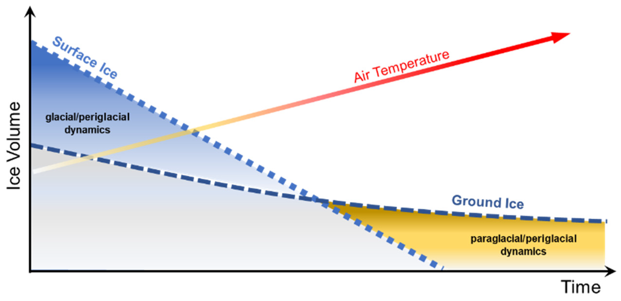
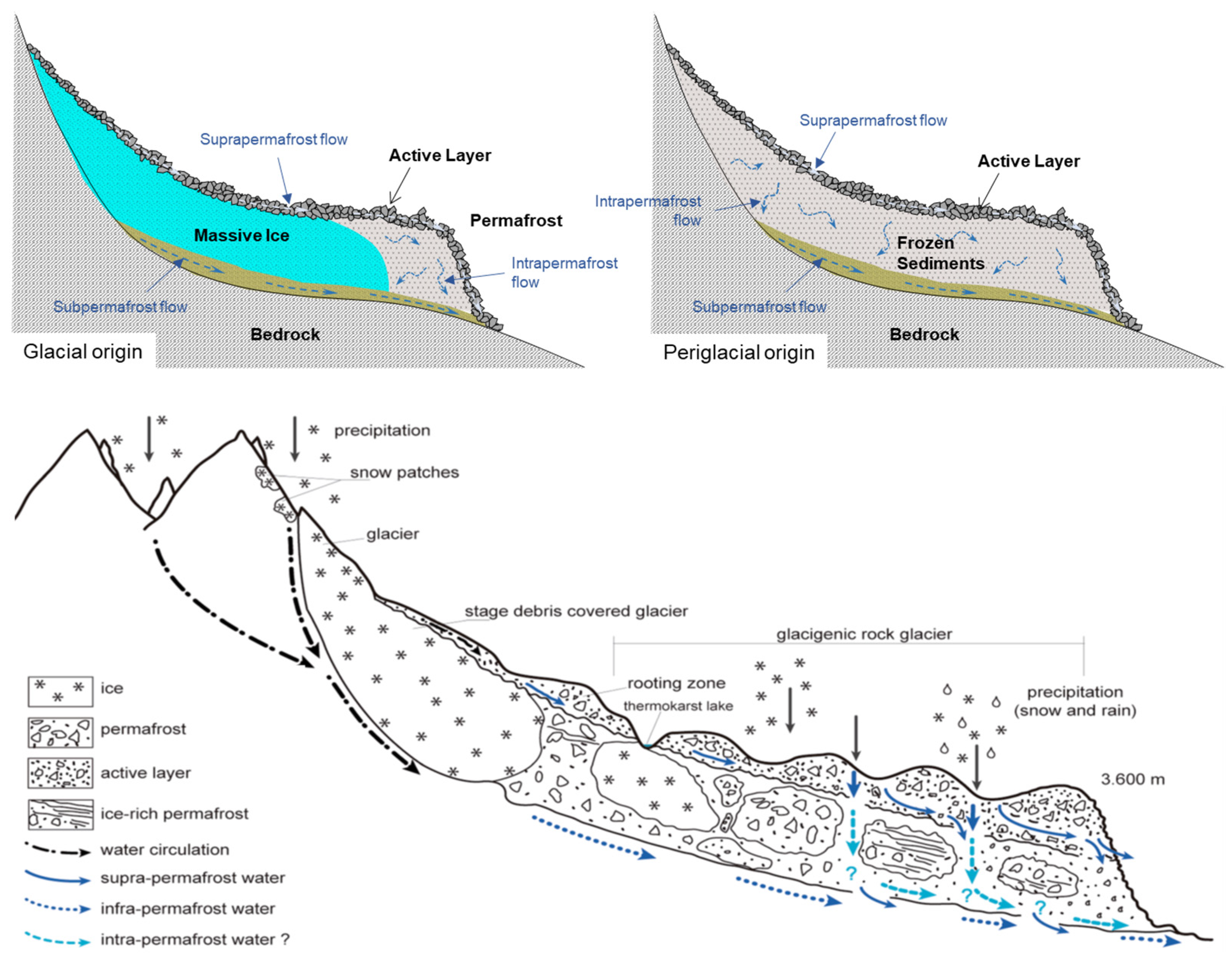
Climate change is expected to have a major impact on mountain regions, leading to reduced water security around the world [1,2]. Consequently, mountain water resources are expected to be stressed due to increases in air temperature, sublimation, and evapotranspiration, as well as changes in precipitation patterns, particularly in arid and semi-arid zones, such as the Dry Andes of South America [1]. Mountain glaciers around the world are receding under a changing climate (e.g., [3,4,5]), shifting the predominant dynamics of the mountain cryosphere from glacial to periglacial (Figure 1), which has, depending on the area, implications for mountain water resources [6]. The influence of this shift from glacial to periglacial dynamics on mountain hydrology is due to major differences in the rate at which these two environments respond to atmospheric changes, superimposing shifts in hydrology due to projected changes in snow cover and precipitation pattern. Surface ice responds much faster to climatic change than ground ice, which is insulated from the atmosphere by the active layer and often by snow [6,7]. Because heat transfer to the subsurface is attenuated according to the physical properties of the ground, increases in heat fluxes acting on permafrost due to climate warming are delayed and dampened compared to for glaciers, resulting in melt rates of ground ice being substantially lower than for surface ice (Figure 1). While melt rates of surface ice would remain relatively constant if climate warming rates did not change, ground ice melt rates could decrease with time in response to a thickening of overlying unfrozen materials (i.e., active layer deepening), provided that the unfrozen material is not removed by mass movement processes [8,9,10].
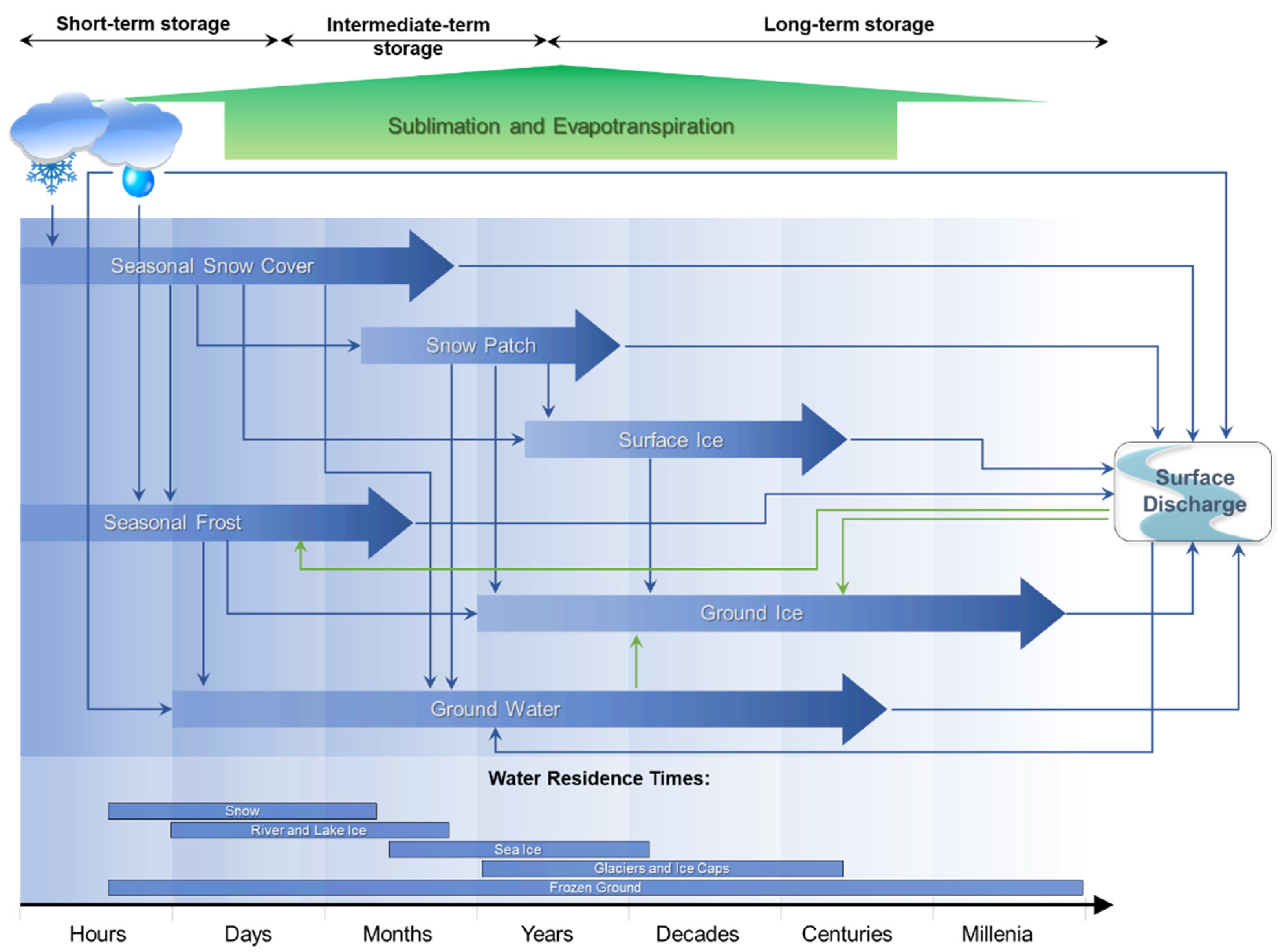
The freeze–thaw dynamics of surface ice, i.e., found in glaciers and on lakes, are vastly different from the dynamics of ground ice, which can be found ranging from near the ground surface seasonally during the winter to depths of hundreds of metres in some regions. Therefore, ground ice may be much older than surface ice [11,12], specifically in smaller surface ice bodies that are found in mountainous environments (Figure 2). To put this into perspective of a global hydrological cycle, average residence times of groundwater can range from ~200 to 10,000 years (depending on spatial scale), whereas residence times of lakes can be ~100 years, and rivers as low as two weeks [13]. An attempt to summarize the complexity of flow paths and temporary water storages in a glacial/periglacial watershed is presented in Figure 2. Every drop of precipitation, whether deposited in liquid or solid form, will ultimately leave the watershed, and snow patches, glaciers, or rock glaciers, act as temporal storages along with lakes and groundwater, i.e., they are not the origin of the water recorded as discharge. The figure focuses on the pathway from precipitation to surficial flow; however, some water either sublimates or evaporates. Specifically in the high and arid mountain regions of the world, sublimation rates can be substantial, reaching more than 80% [14,15]. A raindrop or a snowflake can pass through various temporary storages or cryoforms before it leaves a mountainous watershed. For example, it may start as snow, be compressed to firn and to surface ice (a glacier), from where it can melt, potentially infiltrate, freeze within the active layer for one winter (seasonal ground ice), melt again and infiltrate to greater depths, then later flow towards a permafrost body where the droplet segregates and remains in the ground as ground ice for several thousand years. Eventually, this part of the permafrost degrades, releasing the drop of water that then flows as groundwater until it typically surfaces at a spring and joins the surface drainage system. Following this schematic, it also becomes apparent that the active layer influences near-surface water storage and drainage [16,17,18].
Glacier hydrology has long been a major focus of scientific research and the role of glaciers within the hydrological cycle is well understood, with seasonal melt from glaciers known to contribute substantial amounts of water to runoff (e.g., [20,21,22]). Conversely, it is unclear whether ground-ice melt from thawing mountain permafrost contributes meaningful amounts of water to the water cycle. Furthermore, most research in this area has focused on rock glaciers [23,24], which represent only a small component of mountain permafrost. Limited research has been completed on the influence of climate change in mountain watersheds characterized by the presence of permafrost and studies to date highlight the lack of data in these environments [25,26,27,28]. In the context of rock glaciers in the Dry Andes, conclusions of two recent studies [27,29] illustrate how the current state of knowledge on mountain permafrost hydrology is conflicting. Falaschi et al. [27] stated that “Rock glaciers near the Andean mountains of central and northwestern Argentina provide an important supply of water for agriculture, but data on their number, size, geographic distribution and altitudinal range are poorly known”, suggesting that the role of rock glaciers contributing to streamflow had been established. Conversely, Schaffer et al. [29] wrote more recently that “There is insufficient knowledge available to adequately quantify the hydrological contribution of rock glaciers to streamflow within the semiarid Andes [27°–35° S]”; hence, they concluded that “It is therefore important to quantify the hydrological importance of rock glaciers in order to provide adequate protection to ensure sufficient water availability for future generations.”.
The mountain permafrost environment is highly heterogeneous, particularly outside of polar regions, as temperature and tropical mountains are subject to large spatial and temporal differences in climate conditions and ground conditions can vary substantially over short distances. Therefore, the extrapolation of conclusions from limited rock glacier hydrology studies to generalize permafrost hydrology of mountain watersheds is a scientific oversimplification that creates critical limitations for water management planning and policy making and may be raising wrong expectations related to freshwater availability. This generalized perspective neglects complex differences and interactions between glacial and periglacial environments in terms of process and scale, limiting the ability of scientists to estimate how climate change induced modifications to the hydrology of mountain watersheds could influence natural and socio-economic environments in the future. This knowledge gap amplifies uncertainties in projections of future change and increases associated environmental risks, consequently presenting challenges for water management, project development, and mitigation planning.
This review provides an overview of available permafrost hydrology literature with a focus on mountainous terrains outside polar regions and discusses associated challenges and limitations of the current state of science. In response to major limitations in available research and the authors’ own experience, this review primarily uses observations from the Dry Andes and presents these in a global context. First, general concepts related to permafrost hydrology are introduced, followed by concepts specific to mountain ranges outside polar regions, including detailed aspects related to rock glaciers. This review also includes a focus on climate change impacts on mountain permafrost hydrology and the authors’ views on future research directions. Selected terms are defined throughout this review where their precise definition is of relevance. The reader is referred to van Everdingen [30] for the authoritative glossary of terms related to the periglacial environment.
2. Permafrost Hydrology
Hydrology can be defined as “the geoscience that describes and predicts the occurrence, circulation, and distribution of the water of the earth and its atmosphere” [31]. Permafrost is defined as ground (soil or rock, including ice and organic material) that remains at or below 0 °C for at least two consecutive years [32]. The presence of permafrost influences water flow paths and, to a lesser extent, water sources and storage mechanisms [33]. The widespread distribution of permafrost across the globe [34] and its unique hydrological effects have led to the study and development of the field of permafrost hydrology.
The primary influence on water movement exerted by permafrost is through physically constraining flow. Permafrost thermal state is less important since water flow is possible at temperatures even below 0 °C; for example, in saline waters or under certain grain size and pressurized conditions [35]. Williams and van Everdingen [36] provide a detailed overview of permafrost hydrology in Arctic regions and state that “Permafrost […] acts as a confining bed, and both its composition and distribution have a significant influence on patterns and rates of groundwater flow. […] Groundwater discharge may be restricted to the lower, central part of many river valleys where the permafrost is discontinuous. In some valleys, the resulting strong upward movement of groundwater causes quick conditions and instability of the affected streambeds. In the region of continuous permafrost, unfrozen zones penetrate the permafrost only where salinity of the groundwater prevents freezing, or where heat transfer from a body of surface water or from discharging subpermafrost water is sufficient to maintain the unfrozen condition.”.
In 1975, Dingman [37] concluded that hydrologic effects of permafrost are profoundly non-static due to long-term climate change. He further indicated that permafrost acts as an aquitard, restricting the movement and recharge of groundwater, and stressed that resultant effects on hydrology are not necessarily the expected straightforward ones of increased runoff and flashier streamflow. Studies available at that time suggested long hydrograph recessions for streams draining permafrost areas, and some large basins had a high proportion of their runoff occurring as groundwater outflow [37]. Runoff percentages estimated for small central and northern Alaskan watersheds were moderately high (around 50%) and mostly snowmelt. Dingman [37] continued to stress that seasonal freeze–thaw processes have important dynamic hydrologic impacts influencing infiltration in complicated ways: sometimes increasing and sometimes decreasing it.
In a key reference on permafrost hydrology [33] and a paper published just before that [38], Woo and colleagues concluded that “Permafrost hydrology should continue to be of practical relevance. Hydrologic knowledge is of paramount importance to water supply, flood control, construction, and operation of development projects in permafrost regions. Hydrologic information available to other branches of science and engineering is crucial to the management of fish and wildlife habitats, forestry and agriculture, aquatic waste disposal and community health.”. The authors continue stressing that despite recent advances in the understanding of permafrost hydrologic processes, ground-based observations, which are still scarce in polar regions, are critical and there are substantial limitations when those are substituted by remote sensing.
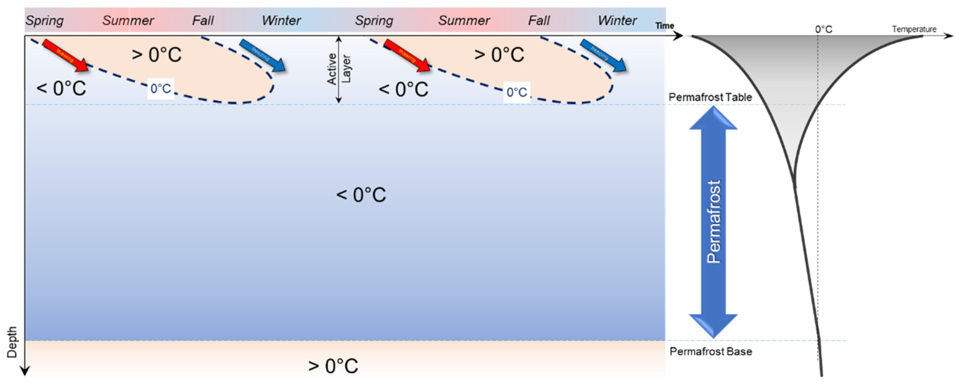
Permafrost hydrology is controlled by the spatial and temporal peculiarities of permafrost. The technical definition of permafrost, as presented by Muller [32], has already been introduced. This can be illustrated schematically, as shown in Figure 3, for steady climatic conditions where the changes in temperature over time and with depth are presented. If the minimum and the maximum temperature at each depth is plotted, the figure on the right is obtained, which is known as the temperature trumpet curve [30]. Freezing and thawing processes, also referred to as frost action, occur within the top layer of the ground, known as the active layer, which is not part of the permafrost. In the winter, when the ground is completely frozen, the active layer forms an aquitard. As the active layer develops during the summer, flow within these shallow soil layers may occur, changing the overall flow regime as it becomes dependent on the soil’s hydrological characteristics, often related to unsaturated flow conditions [39]. In addition, the time of concentration increases as the active layer develops. As the active layer starts to refreeze, mainly from the surface, but also to a lesser degree from the permafrost table upwards, flow may initially be limited to an ever-thinning layer that will eventually freeze, creating a completely frozen aquitard once more. Only towards the end of the summer when the active layer is fully developed, water frozen in the permafrost may be released if the active layer penetrates deeper than it had during previous years, hence, permafrost is degrading.
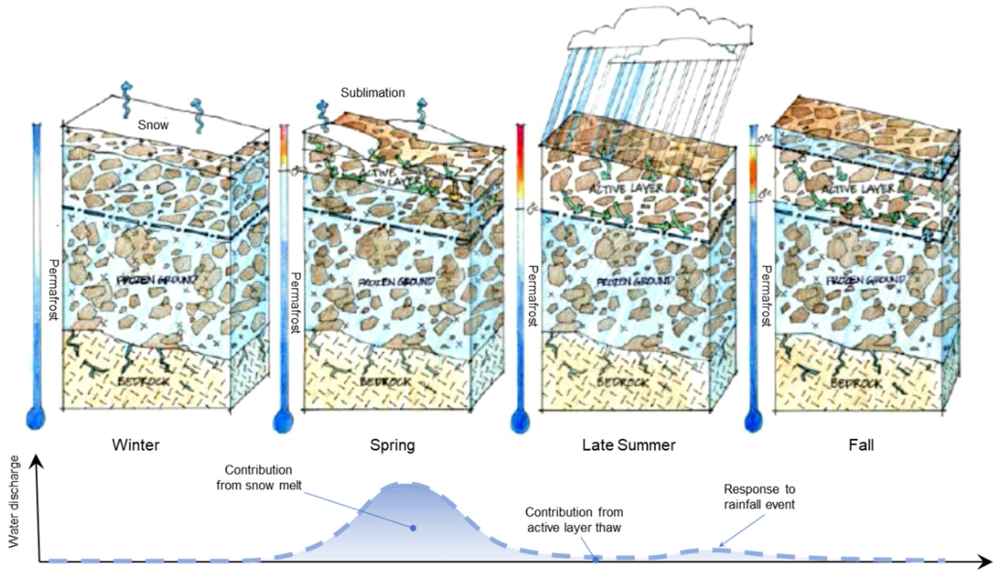
Without permafrost degradation, discharge originating from an area with permafrost can be water released from seasonal storage in the active layer (Figure 4) or sub-permafrost groundwater. During the winter, the ground is frozen, and a snow cover may be present. The combined effect of intense solar radiation, high wind speeds and low air relative humidity in many mountain regions of the world results in a substantial amount of snow sublimation [14,15,40]. As the snow cover disappears, surface runoff may occur and complex infiltration processes form, which have been discussed with respect to geohazards [41,42]. As the active layer thickens during the summer, moisture that had been frozen in the previous fall and winter, forming seasonally frozen ground, will melt and can potentially contribute to runoff. It is, however, important to note that active layer deepening is a slow process and therefore the amount of water that can thaw is limited. In order to melt 1 kg of ice, 334 kJ of energy is required [43]. Due to the insulating and, hence, dampening effect of the active layer, the deeper into the ground, the less energy is available for ground ice thawing; therefore, the melting of ground ice and the advancement of the thaw front decelerates over time, similar to the penetration of the freezing front in the winter [43]. The contribution from active layer thaw to the discharge is, therefore, small, and increases noted in the hydrograph are likely related to precipitation, flow through the active layer, or deeper groundwater flow. Watersheds underlain by permafrost tend to have a quick response to precipitation in the summer, resulting in their hydrographs peaking earlier than basins without permafrost [44] (low concentration time). As the ground starts to freeze back, the active layer discharge from permafrost underlain areas ceases. In general, permafrost acts as an aquitard and the active layer acts as a seasonal aquifer and seasonal ice storage from the previous year’s snowmelt, for example.
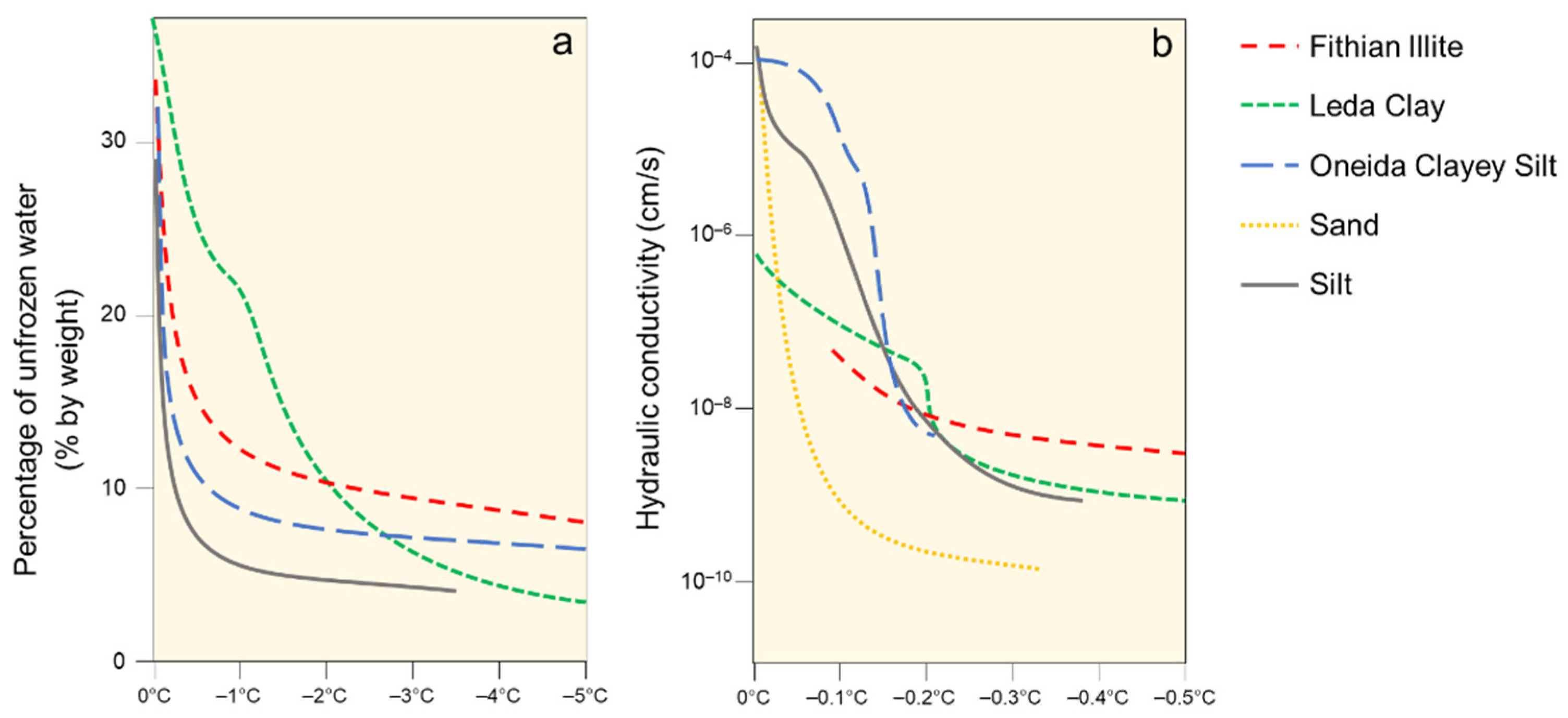
The processes described above are further complicated by heterogeneity in the ground conditions that impact the unfrozen moisture content and hydraulic conductivity of frozen or partially frozen ground [45,46,47], and also influence the moisture dependent thermal properties [48] and the ground thermal regime. Pore water freezes as temperature decreases below 0 °C; however, not all pore water freezes, and a substantial unfrozen water content can persist well below 0 °C, depending on the soil properties (Figure 5), pore water salinity, and pore water pressure [49,50]. The decrease in unfrozen water content results in a concurrent decrease in hydraulic conductivity (Figure 5). Permafrost represents a thermal state, not a physical state, such that the ground ice content of permafrost may range from fully ice-saturated to zero volumetric ground ice content, and its hydraulic conductivity may range from its unfrozen and saturated hydraulic conductivity to several orders of magnitude lower. Furthermore, water flow is often responsible for the formation of taliks because of heat advection and convection, i.e., the transport of heat with flowing water [37]. Permafrost degradation is controlled primarily through heat transfer from the ground surface; however, the diffusive and advective processes through supra-, intra-, and sub-permafrost taliks can accelerate degradation and alter local hydrology in complex ways.
Water and permafrost are interrelated in different ways. Water influences the distribution and thermal regime of permafrost, whereas the spatial distribution, depth, and thickness of the permafrost body has an effect on hydrology, runoff, and infiltration [51]. In areas of discontinuous permafrost, precipitation further influences the depth of seasonal thaw and the ground thermal regime [52]. Specifically, the soil moisture content immediately prior to freezing in the fall determines the ice content of this layer. The amount of surface water and infiltration capacity of the soil then influences the depth of thaw during the following summer [52].
The main effect of permafrost on the hydrology of a watershed is the restriction, but not exclusion, of an exchange between surface waters and subpermafrost groundwater [53]. If the exchange is sufficiently restricted, the result is a perched water table within the active layer above the permafrost table. This vertical flow restriction may result in surficial ponding of water within flat terrain and high rates of surface soil erosion in steeper terrain, where surface runoff is considerable due to limited infiltration [53]. Rising and lowering of the water table between a low-conductivity layer and an overlying high-conductivity layer within the active layer may trigger a threshold response behaviour, similar to the ‘transmissivity feedback’ mechanism [54]. Finally, subpermafrost layers are typical aquifers within permafrost environments and it is not unusual that they are confined [55,56].
3. Mountain Permafrost Hydrology
Hydrological processes within mountainous terrain are strongly influenced by local topography and the type of surficial material. Therefore, it is important to differentiate hydrological processes that occur within polar regions from those where topographic impacts are essential, such as in the Dry Andes. The flow of water, but also mass movements, such as creep of ice-rich sediments, snow avalanches, debris flows, rock falls, or other forms of landslides, are controlled by gravity and local topography [42]. In addition, solar radiation in mountainous terrain varies greatly within short distances in response to slope aspect, elevation, and local shading [57]. Together with microclimatic conditions, this forms a complex and heterogeneous permafrost distribution [58,59,60]. The three main factors controlling this distribution are:
- The surface energy balance, largely driven by atmospheric conditions, which controls heat inputs to and outputs from the Earth’s surface;
- The heat derived from the Earth’s interior, which is generally defined by the geothermal gradient at depth; and
- The presence of surface (lakes or rivers) or subsurface (taliks) bodies of water that do not freeze completely during the winter.
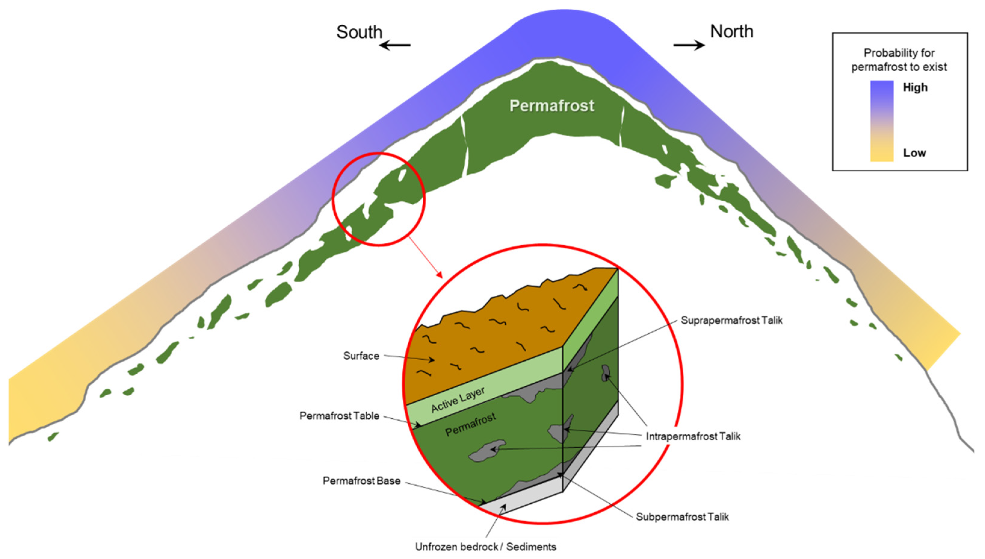
In consequence, the concept of continuous and discontinuous permafrost, as it is used within a polar context, should not be applied within mountainous environments. It is recommended to either use mountain permafrost as a general term that inherently implies the complex and heterogeneous nature of permafrost within a mountainous environment, or a permafrost probability, for example, from a permafrost distribution model [61,62,63]. Regardless of whether a permafrost region is presented in a polar (continuous–discontinuous) context or within mountains, the actual extent of the permafrost is substantially smaller than the extent of a permafrost zone or region [64] and there is also a key depth component associated with permafrost distribution.
In the southern hemisphere, north facing slopes along mountain ridges are typically warmer than south facing slopes because of the difference in solar radiation, impacting the permafrost distribution (Figure 6). With increasing elevation, the extent of the permafrost and its depth increases, and the number of non-permafrost zones decreases. The mountain ridge shown in Figure 6 is located within a permafrost region, i.e., a geographical area where permafrost may be present. However, the continuity within the permafrost body itself decreases with decreasing elevation allowing, even strictly from a thermal perspective, more infiltration and both groundwater recharge and discharge. In parallel, permafrost temperatures increase at lower elevations, further influencing the unfrozen moisture content and hydraulic conductivity of the frozen sediments (Figure 5). Different types of taliks may allow for water to flow through the system, influencing the regional distribution of hydraulic conductivity and, hence, the distribution of relatively permeable and less permeable pathways for groundwater flow.
However, while the presence of permafrost and taliks may be critical for understanding groundwater recharge, flow, temporal storage, and discharge, it is essential to consider its presence within the larger context of the local hydrogeological characteristics. Ultimately, permafrost, nor a periglacial cryoform, can ever be the origin of water within a mountainous watershed, but its presence may influence groundwater recharge and surface runoff hydrographs at varying times.
In addition, the hydrology in mountain regions is highly controlled by local weather patterns, air temperature, and elevation, which determine the spatial distribution of precipitation and its physical state (i.e., solid or liquid). In general terms, mountainous environments, which are often composed of a multitude of different landforms (Figure 7), are regulators of the downstream hydrology [65]. Winter precipitation, typically snow, is stored on the surface by accumulation. This is especially true for a glacier dominated watershed that stores water in the form of surface ice and snow. A dry winter landscape forms at high elevation with wetter conditions downstream, where precipitation falls in the form of rain. During spring and summer, when rain is often marginal at lower elevations, surface ice and snowmelt provide water for surficial runoff.
In mountain catchments, most of the water from snowmelt and rain flows through the ground before entering a stream [23], depending on the local type of surface material that largely controls infiltration capacity. Permafrost directs the hydrology mainly by changing flow paths due to the lower storage capacity induced by the decreased unfrozen water content and hydraulic conductivity of frozen soil [17,66] and bedrock [67,68], or other secondary processes, such as lake damming by rock glaciers [69]. Notable water accumulations were, for example, visible in the 2017 Pizzo Cengalo, Switzerland rock avalanche detachment zone [70,71].
During a research study where near-surface runoff in a coarse grained surface layer and base flow in a finer-grained layer below the permafrost base of a rock glacier were differentiated, Krainer and Mostler [72] concluded that snowmelt was the dominant water source during spring, whereas rain water dominated during summer. Although direct contribution from snowmelt and surface ice melt can generally be identified in watershed hydrographs (Figure 4), there is a fundamental difference between melt of snow ice on the surface compared to melt of ground ice, e.g., from permafrost thaw. Snow and surface ice are directly exposed to atmospheric conditions, including solar radiation and air temperature, and respond instantaneously to changing conditions. For example, runoff from glacier melt is the highest towards the afternoon in direct response to daily maxima of air temperature and solar radiation. Ground ice, on the other hand, is controlled by ground temperatures as it is insulated from solar radiation by snow during the winter and overlying soil or rock during the summer. Further, changes in ground temperature with time and depth depend on the thermal conductivity and heat capacity of the ground, convective heat transfer parameters, and the latent heat of fusion [73]. Therefore, there is a lag for summer temperatures to penetrate the subsurface and to melt any ground ice at depth [43]. Given the temporal lags in temperature propagation with depth, it is challenging to directly link watershed hydrographs for a whole basin to permafrost degradation and associated ground ice melt, or to differentiate between contributions from seasonally versus permanently frozen ground. In response to an increase in the storage capacity of the sediments due to permafrost degradation, a decrease in flood peak runoff and an increase in runoff during recession periods are likely [17]. Frampton et al. [74] used a three-phase water flow model coupled to heat transport to show decreased seasonal variability in groundwater discharge may serve as an early indicator of permafrost degradation, since increased annual mean flows may take a longer time to become apparent.
4. Rock Glacier Hydrology
The hydrology of the glacial environment in mountainous areas has been well studied for decades [21,22,65,75]. However, hydrological studies on mountain permafrost are still relatively novel and much research in this field has focussed on rock glaciers [76]. There is currently no consensus on the relationship between rock glaciers and their hydrology in terms of water storage and their potential contributions to runoff and/or discharge quantities [29].
Several authors have suggested that rock glaciers, for example in the Dry Andes and the Himalaya, are hydrologically important or significant based on the potential volume of water stored in permafrost ground ice estimated using empirical approaches [24,76,77,78,79,80,81,82,83,84,85,86,87]. Empirical estimates of ground ice volume are subject to substantial uncertainties; for example, Jones et al. [76] wrote in a review of these studies that: “[…] potential bias may be introduced by the typically lower ice contents of inactive [rock glaciers]. Additionally, information regarding [rock glacier] genesis, i.e., permafrost origin or glaciogenic origin, is predominantly absent within the [rock glacier database] (RGDB) despite strongly influencing ice content. Therefore, we acknowledge that due to the nature of the RGDB and the methodology, we cannot comprehensively account for regional specificities. Further research related to ice-thickness and ice content by volume is certainly needed. […] Therefore, overall uncertainty is likely larger than that quantified here.”. These approaches to estimating the volume of water stored as ground ice require simplifying assumptions, such as a rock glacier area–volume relationship that has major uncertainties and should be avoided [88], volumetric ground ice content, and to a lesser extent ice density.
However, the potential water storage capacity of rock glaciers (and mountain permafrost in general) in ground ice does not indicate their ability to contribute measurable volumes of water to streamflow, which instead depends on the heat fluxes acting on ground ice. Many studies on rock glacier hydrology do not evaluate the actual water supply of rock glaciers at discharge points or availability to downstream users, but rather roughly estimate the volume of water stored as ground ice or extrapolated from water observed downstream of a rock glacier, independent on its actual origin. The value of these studies is therefore limited to the insight they provide on the overall storage of water in mountainous regions.
Some publications use the terminology hydrological significance for rock glaciers [29,79,81,86]. However, its meaning is typically not clearly defined. Often, the stated significance seems to be understood as the sole existence of a (frozen) reservoir or the ability to act like an aquifer. As illustrated in this review, the hydrological behaviour of rock glaciers and mountain permafrost in general cannot be assigned a single unchanging function, and the hydrological outcomes driven by the presence of mountain permafrost will vary greatly depending on the processes and climate acting on each watershed. Therefore, the hydrological significance of a specific rock glacier, or permafrost in general, should be clearly defined in studies, e.g., with respect to runoff, and assessing significance should be carried out in a quantifiable and statistical context relative to the hydrology of the entire watershed, acknowledging other relative contributors.
4.1. Rock Glacier Volume Change
Rock glaciers have received much scientific attention from geomorphological, climatic, and kinematic perspectives [89,90,91,92,93,94,95], but only a few studies focused on quantifying their hydrological behaviour from surface and subsurface perspectives, e.g., [72,96,97,98]. This limited number of study results, often conducted in challenging field conditions which limit investigation methods, results in continued uncertainty as to their potential hydrological roles. There have been few studies on the quantification of the hydraulic contribution of ground ice melt to runoff; most of them were unable to achieve results due to the considerable uncertainties involved in calculating the water balance [99]. For example, Krainer et al. [97] were not able to resolve isotopic similarity of precipitation and rock glacier ground ice melt. More recently, at a different rock glacier, Krainer et al. [11] found an average annual rate of ground ice melt from thawing permafrost of 10 cm/year, which represented only 2.3% of the average discharge from the rock glacier catchment area. Even if the melt rate of ground ice was doubled to 20 cm/year, this would amount to less than 5% of the average discharge from the rock glacier catchment area. Because the contribution of permafrost ground ice melt to discharge in these studies is small to begin with, marginal additional contributions from melting ground ice would be difficult to measure and are likely to be within the range of sensor uncertainty or natural variability of catchment hydrology. Often, climatic conditions within mountain environments vary greatly from year to year, adding an additional level of complexity when assessing an individual contribution as near average conditions rarely occur. Recent advances in geophysical methods (e.g., [100]) have demonstrated an ability to estimate permafrost degradation; however, uncertainties in the methodology, which are sometimes difficult to quantify, must to be considered. Measurements of ground heat flux and simple heat transfer calculations have been used to estimate a conservative upper bound of ground ice melt representing less than 1% of the discharge between June and October from an inactive rock glacier’s catchment [101]. Finally, using a theoretical approach, Arenson et al. [102] showed that ground ice melt from rock glaciers due to permafrost degradation in a mountainous basin would account for less than 0.1% of annual basin runoff, assuming a 100-year air temperature increase of 4 °C.
The Swiss Permafrost Monitoring Network [103] probably has the most comprehensive compilation of ground temperature measurements, annual thaw depth data, and ground ice content for individual rock glaciers [104,105,106]. Based on available data, the average annual ground ice melt rates of these rock glaciers are less than 5 cm/year.
Some studies have estimated annual ground ice loss using remote sensing [23]. The available data indicate highly variable annual ice creep rates with annual surface subsidence ranging from centimetres to decimetres. Estimated volume losses ranged from 320 m3 to 7515 m3 for the Schafberg rock glacier in Switzerland and the Hinteres Langtalkar rock glacier in Austria, respectively [23,107]. Volume changes of one of these rock glaciers may be attributed to ground ice melt, whereas the much larger volume loss recorded for the other rock glacier can be attributed to detachments of sediments at the rock glacier front, i.e., unrelated to the release of water.
4.2. Glacier vs. Rock Glacier
The influence of the insulating layer of soil or rock overlying permafrost, typically the active layer, on the ground ice melt rate of permafrost thaw has already been introduced and the primary differences to the melting of glacier ice discussed. With respect to rock glaciers, the difference in the dynamics between a glacier and a rock glacier is worth reviewing. Glaciers constantly exchange their ice mass. Snow is accumulated at high elevation, turning into glacier ice that creeps internally to the glacier front where it ablates and the ice melt contributes to glacier runoff [108]. If the glacier mass balance is positive, more ice mass advances than can melt, and if the mass balance is negative, the glacier recedes. The total melt of glacier ice is directly linked with the glacier advance. On the other hand, rock glaciers, whether of glacial or periglacial origin [76], do not have a mass balance in glaciological terms. There is no annual accumulation or ablation of ice that would control its dynamics and therefore the advancement of a rock glacier is not linked to a mass balance. While a rock glacier can slowly creep downslope due to gravity, which is mainly controlled by local topography, ground ice would not melt in direct response to the minor advancement of a rock glacier, which is in the orders of centimeters to meters per year [89,103,109].
4.3. Hydrological Characteristics of Rock Glaciers
There is no clear consensus on how a rock glacier should be defined [91]. It is, however, important that some understanding exists on what constitutes a rock glacier, in order to assess its hydrological role in mountain watersheds. The term “rock glacier” was originally coined in 1910 by Capps [95] where he wrote: “The rock glaciers also differ from true glaciers in that, although they may advance spasmodically, or at varying rates, they never retreat, for their form remains intact even if the ice melts out and movement ceases.”, which is a critical observation. More than a century later, discussions are still ongoing, with attempts being made to offer a technical definition for applications such as inventorying, for example [110]: “Rock glaciers are debris landforms generated by the former or current creep of frozen ground (permafrost), detectable in the landscape with the following morphologies: front lateral margins and optionally ridge-and-furrow surface topography. In a geomorphological slope sequence, rock glaciers are landforms conveying (or having conveyed) debris from an upslope area (source area or rooting zone) towards their front.”
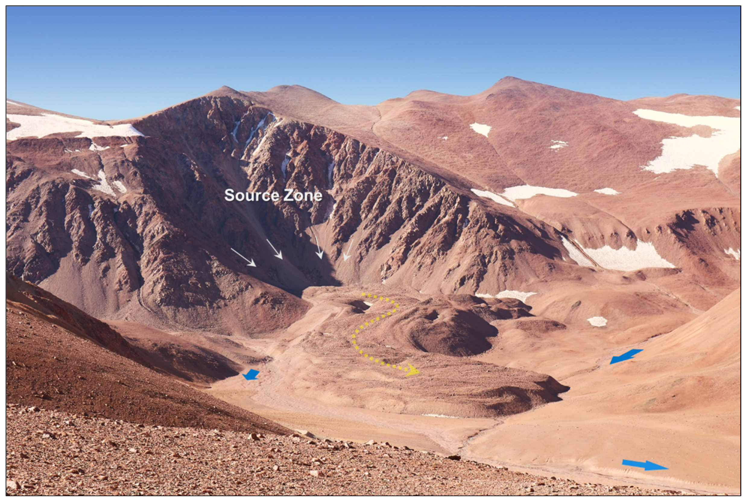
An example of a cryogenic rock glacier in the Central Andes with complex drainage conditions is shown in Figure 8. The illustrative photograph shows the source zone and gravity induced creep deformation of the ice-rich frozen soil mixture with its characteristic surface composed of furrows and ridges. Water from seasonal melting of the upslope snowpack flows in streams surrounding the landform in its current configuration, partially also because the permafrost within the rock glacier creates a frozen dike. Water also emerges from a spring at the front of the rock glacier. Field observations suggest that the stream that is currently shown at this front was likely present prior to the rock glacier advancing to its current position, and that the existing topographic and hydrogeologic conditions of the rock glacier would support continued drainage of water below the base of the rock glacier. This is because the material at the base of this type of rock glacier is often coarse [105] and therefore likely to have a high hydraulic conductivity. In addition, the rock glacier is expected to naturally advance following the lowest point of a valley as a stream of frozen sediments, comparable to a lava flow. Therefore, water from the rock glacier surroundings will naturally accumulate below the rock glacier (i.e., where it would have accumulated prior to the rock glacier advancing) and resurface at the rock glacier front. This scenario is applicable to this example rock glacier and may or may not be transferable to other rock glaciers, as there are a myriad of geomorphologic and topo-climatic conditions that can create complex hydrological characteristics within rock glaciers [89,110] themselves. Furthermore, rock glaciers often change surface water drainage conditions post-advancing. Thus, a holistic assessment of rock glacier hydrology requires an understanding of basin drainage conditions prior to rock glacier advance, its origin and genesis, as well as an understanding of ongoing geomorphologic changes that can influence internal drainage of the landform.
Water within rock glaciers can be present as perennially frozen in permafrost, seasonally frozen in the active layer, or perennially unfrozen in taliks where present. The distinction between water in different states is not particularly specific to rock glaciers and is broadly applicable to mountain permafrost. Rock glaciers are traditionally classified as one of three types: active, inactive, and relict (e.g., [89]), of which active and inactive rock glaciers are sometimes grouped together and referred to as intact. Relict rock glaciers, which no longer contain ground ice and, therefore, are not part of the periglacial environment, are not discussed in this review. Active rock glaciers consist of ground ice in the form of matrix ice and/or massive ice, depending on its origin and genesis, and ground ice melt from the rock glacier could supply water to downstream users only if the permafrost is degrading [111]. Due to the thermally insulating effect of the active layer [18], latent heat effects, and the slow conduction of heat through the ground, the degradation of intact rock glaciers is a slow process and only occurs under climatic conditions where permafrost would not form.
Rock glaciers transition from active to inactive and eventually to relict over centennial to millennial time scales. For example, Krainer et al. [11], Konrad et al. [112], and Haeberli et al. [12] dated rock glaciers in Austria, Wyoming and Switzerland and found that they formed before the Little Ice Age, containing ice dating to the middle Holocene or earlier. On the other hand, glaciers of a comparable ice volume lose ice at rates that are orders of magnitude higher. This explains why many small glaciers in the European Alps have completely disappeared since the Little Ice Age [5], while in the same time-period, few visible changes have been observed for rock glaciers in the Alps. The latter only react to long-term trends in changes in precipitation [113,114] and longer-term (decadal/centennial scale) air temperature variability [115], being insulated from short-term variability in air temperature. Glaciers on the other hand are far more sensitive to changes in precipitation and air temperature. For this reason, more rock glaciers than glaciers exist in the arid areas of the world, such as the Dry Andes.
4.4. Ground Thermal Regime
Atmospheric conditions induce complex energy fluxes within the active layer of a rock glacier, which in turn control the thermal regime and evolution of the landform [116,117]. Mass gain occurs in the form of snow and ice, groundwater, precipitation, and debris. Mass loss of interstitial ice comes from various forms of permafrost degradation, but due to the thermal protection of the ground ice, changes in the permafrost temperature are slow and delayed with respect to modern climate. Because ice contents within rock glaciers are often high and the thickness of the ice containing sediments substantial, the lag between rock glacier temperatures and changes in temperature at the ground surface is probably higher compared to other permafrost zones within the periglacial belt. In addition, active layers consisting of coarse blocks, which are often found in regions where metamorphic rocks are dominant, allow air convection to increase heat extraction during the winter [118,119]. However, permafrost is unlikely to be in equilibrium with the modern climate, specifically in current times when climate is changing at unprecedented rates [1,2]. The lag between permafrost temperatures and modern climate has been recognized for decades, which allows extraction of historic climate conditions from deep permafrost temperature readings [7,120].
Rock glaciers, or in more general terms mountain permafrost, may not be sufficiently deep to extract changes in the geothermal gradient, but as illustrated in Figure 9, temperatures within shallow permafrost do not adjust evenly at all depths, but the warming penetrates from the ground surface. While temperatures close to the base of the permafrost are still reflecting colder atmospheric conditions, ground temperatures at the permafrost table slowly adjust to modern conditions. The permafrost table slowly penetrates deeper as a function of the ground thermal properties and ground ice content. The more ground ice is available, the slower the penetration due to the latent heat effect. As climate is warming, a condition may be reached where the summer thaw penetration exceeds the frost penetration during the winter. While permafrost conditions are still present at depth, a layer (suprapermafrost talik (Figure 6)) forms that remains unfrozen throughout the year. The layer now has hydrological implications because it allows drainage all year round. Moisture that may have been trapped within the active layer prior to the formation of this suprapermafrost talik may now no longer freeze and is allowed to drain.
4.5. Water Quality and Isotopes
Water chemistry and temperature of discharge observed at the front of rock glaciers have been investigated to better understand environments and water usages downstream. Elevated natural heavy metal concentrations noted in mountain streams have been attributed to melting of ground ice from some rock glaciers [121,122,123]. Elevated levels of acid rock drainage were further observed to drain into a lake at the toe of a rock glacier in the Central Alps, which likely began at the onset of acidic drainage in the freshly deglaciated area [124]. However, it could not be associated exclusively with enhanced thawing of the rock glacier ground ice in recent years. Concentrations of solutes [125] and nitrate [126] observed in runoff at the toe of rock glaciers were attributed to ground ice melt and microbial communities in the cold environment, respectively. Isotopes were used to show the complexity of the fast flow component of rock glacier discharge during dry summer months in particular if a glacier still exists in the catchment [96,127]. Water derived from ice melt is suggested to be provided mainly by melting of two small cirque glaciers within the catchment and subordinately by melting of permafrost ice of the rock glacier.
Observations of discharge at the foot of rock glaciers and glaciers suggest that rock glacier meltwaters, which showed higher solute concentrations, may be representative of what future biogeochemical inputs will be in currently ice-glaciated watersheds [128]. A conceptual model of groundwater flow in an Andean rock glacier was developed by Trombotto-Liaudat et al. [129] following extensive hydrogeochemical research (Figure 10). The two endmembers of rock glacier origin (glacial and periglacial) added to the figure (after [76]) illustrate the independency of the rock glacier origin on its general water flow behaviour. There is no substantial difference between a massive ice body in a rock glacier of glacial origin and a frozen sediments body in a rock glacier of periglacial origin. Thermally they are both permafrost and due to the presence of an active layer, they are both insulated and protected from the atmosphere and hydrologically the extent to which water may infiltrate may vary.
Finally, water temperatures of discharge observed at the front of rock glaciers have generally been observed to remain below 3 °C throughout the year [72,101,125,130,131,132], indicating that if discharge is present from water that may be flowing on top of the permafrost, at the base, or through the permafrost body of a rock glacier, the presence of the frozen ground influences the thermal characteristics of the water and potentially its quality.
Geochemical mixing analysis was used in the United States to estimate water contributions to rock glacier-related drainage, separating snowmelt (30%), groundwater (32%), and baseflow (38%) [125]. By comparing the isotopic variation of discharge observed at the toe of a rock glacier with bare glacier discharge and snowpack values, the authors speculated that the baseflow has a substantial component of ground ice melt water that has been subjected to numerous freeze–thaw cycles (producing an isotopic enrichment signal), therefore likely originating from the active or the transition layer. Similarly, in Italy, Colombo et al. [133,134] concluded that rain occurring after complete melting of the snowpack and a prolonged period of warm temperatures result in a flushing of heavy isotope-enriched waters from melting ground ice.
4.6. Hydrological Role
Rock glaciers are landforms that are identifiable within a periglacial environment from a geomorphological point of view. Fundamentally, they are colluvium that contain or contained excess ground ice that allow creep [48,135]. Therefore, the specific constitution allows the frozen talus and ground ice mixture to creep in response to gravity. Hence, what has been described in the previous section on permafrost hydrology is also applicable to rock glaciers and vice versa. There is an active layer, and its hydrological role can be summarized as a temporal storage of water in the form of seasonal frost during winter months and a groundwater flow path during summer months. As the thaw front penetrates the seasonal frost, this moisture is released. Typically, this water flows laterally on top of the permafrost table at the bottom of the active layer, but some can also infiltrate to greater depths [76,96,132] and result in groundwater recharge or ground ice segregation (Figure 2 and Figure 10).
With decreasing ground ice content and increasing structural hindrance between soil particles [48], a rock glacier may become inactive, which means that it no longer advances. The now inactive rock glacier may show signs of permafrost degradation, such as volume loss and the formation of thermokarst [78,88,136], potentially resulting in a small and slow contribution to surface runoff from the melting ground ice. Once all the ground ice has melted, a relict rock glacier remains, which may not reliably be distinguishable from hummocky moraine deposits. Some are vegetated while some are still bare rocks, depending on the region they reside. They are no longer part of the periglacial environment and are predominantly found at lower elevations.
When addressing the hydrological role of a rock glacier it is irrelevant if rock glaciers or other specific periglacial cryoforms that can be geomorphologically identified and categorized are present within a mountain watershed or not. Of importance is the amount of ground ice and particularly its three-dimensional spatial distribution. Focusing only on rock glaciers because they are recognizable may result in a biased view on the watershed or regional hydrology, as these underestimate how much ground ice may be present. On the other hand, relying on rock glacier ground ice melt to supply streamflow during dry seasons may lead to inaccurate water management planning with less water availability than assumed.
5. Impact of Climate Change
Ground thermal conditions within a permafrost environment are rarely in thermal equilibrium with modern climate, as illustrated earlier in this review. Specifically, there is a lag in the propagation of a thermal anomaly (warming or cooling) from the ground surface to depth, which is a function of the ground’s surface characteristics and the thermal properties of the different ground layers themselves. However, atmospheric warming that has been ongoing since the Little Ice Age, and specifically the accelerated and unprecedented warming recorded in recent decades [2], resulted in warming and degradation of permafrost in most parts of the world [1,70]. The surface heat input to the top of permafrost is typically much greater than the subsurface inputs to the base of permafrost from heat derived from the Earth’s interior. In other words, permafrost is currently controlled primarily by atmospheric conditions (climate) and not by heat at depth (geothermal gradient).
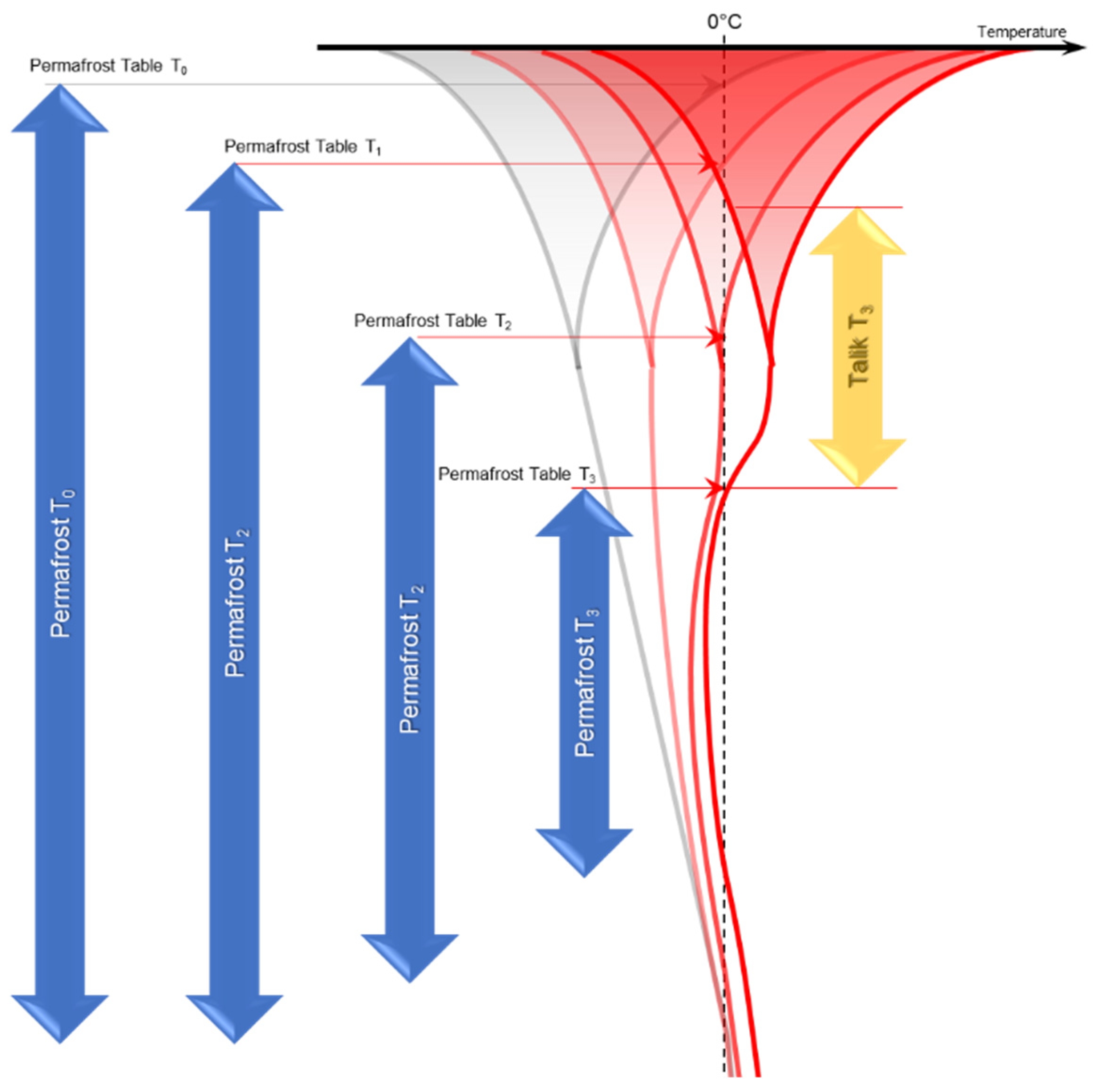
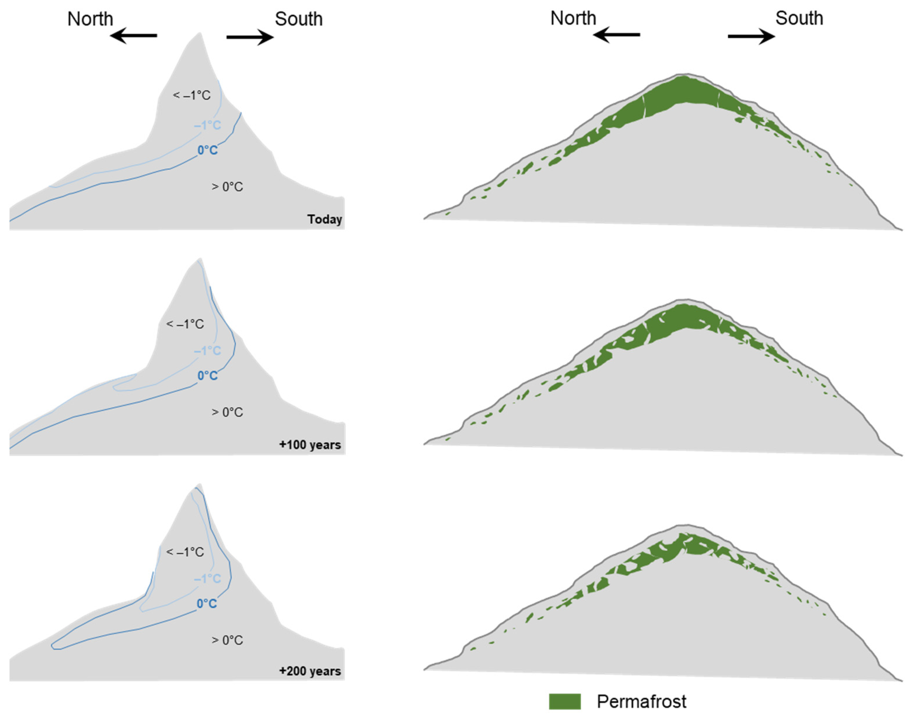
Within mountainous environments, complex topographies impose three-dimensional effects that complicate how the ground thermal regime responds to climate change. A numerical simulation of ground temperatures in a mountain for a period of 200 years showed that south facing slopes warm much faster in the northern hemisphere than north facing slopes [6], resulting in the development of non-symmetric isotherms (Figure 11). The right side of Figure 11 is a schematic representation on how the permafrost distribution in ice-rich slopes may alter over time in response to a warmer climate. As warming will be dominated from the surface, active layer thickening will occur, but permafrost conditions may persist at depth for an extended period. As the extent and the size of a connected permafrost body in elevated zones is reduced, remnants of permafrost may be found at depth and at low elevations even in a distant future. Global warming is therefore most likely causing increased fragmentation of permafrost and the formation of complex talik patterns, including suprapermafrost taliks. Consequently, areas where the ground historically remained frozen from the surface to the permafrost at depth during the winter, can develop layers that stay perennially unfrozen.
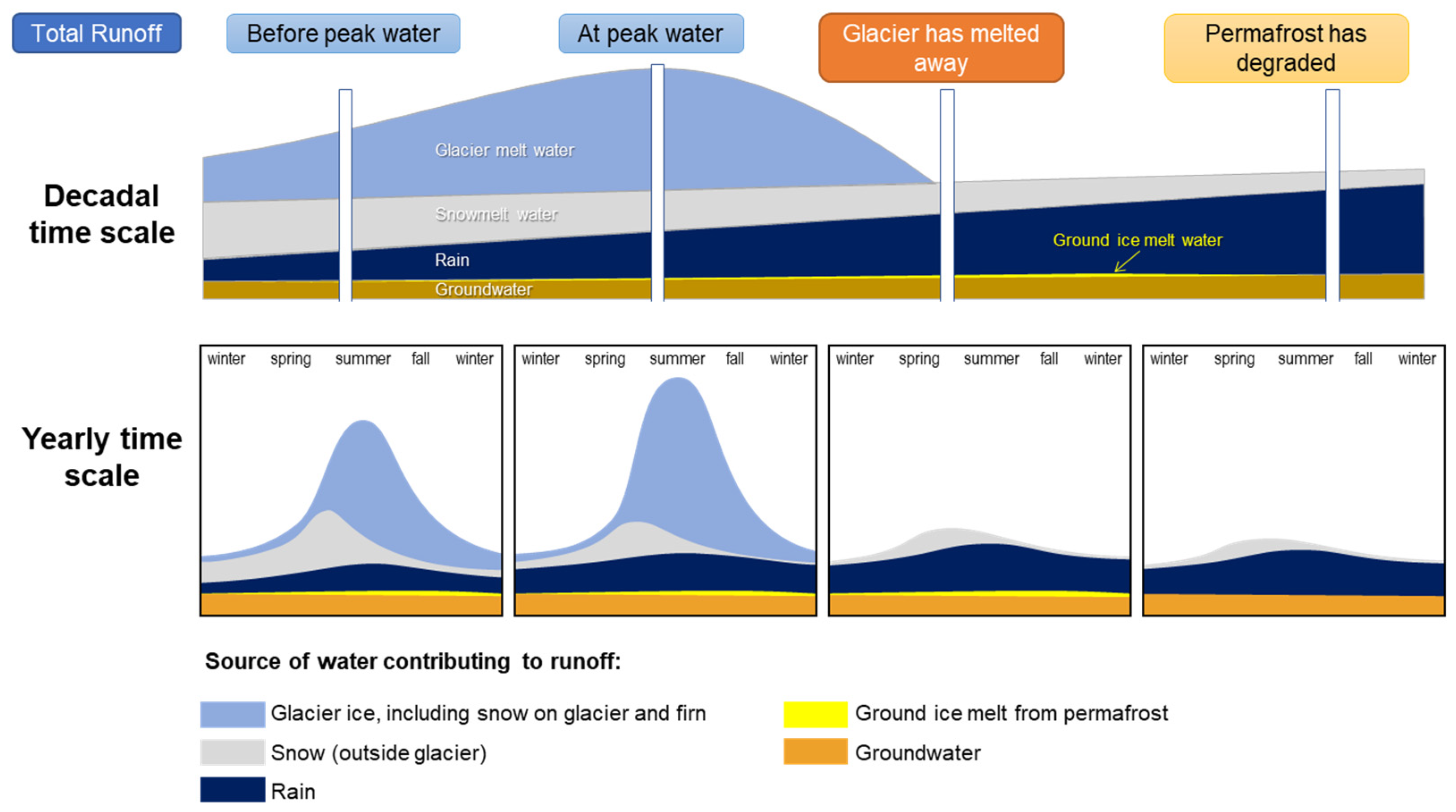
Streamflow in high mountain areas is strongly influenced by climate change and manifested through variations in magnitude, as well as shifts in the timing of peak seasonal surface discharge [1]. Many glacier-dominated mountain watersheds are showing an increase in total discharge in combination with a progressively earlier freshet. This has been observed in Western Canada [137], the European Alps [138,139] and Norway [140], and is generally attributed to increased rain resulting from rising air temperatures and moisture in the atmosphere. Impacts from climate change on summer and average annual discharge are less consistent. Variable changes in summer [138,141,142,143,144,145] and annual discharge [144,146,147,148] were reported for various high mountain regions. Considering the natural dynamics of high mountain regions and the complexity in how glacial and periglacial environments change in response to climate change, such observations are not surprising, reinforcing the diversity in size and complex spatial distribution of snow, surface ice, and ground ice that contribute meltwater within a watershed. As global temperatures rise, water is released from long-term glacial storages and may initially cause summer and annual meltwater yields to increase. However, as glaciers recede or disappear, and those temporary water storages are exhausted, meltwater yield quantities decrease and will eventually fade when glaciers have completely melted within the watershed. Yet, ground ice will melt (permafrost degradation) at a much lower rate (Figure 1). Specifically in arid areas, increased droughts may further delay permafrost degradation because the lack of snow furthers permafrost cooling during winter as more heat can be extracted from the ground [149,150,151], and also prolongs and delays ground temperature warming from solar radiation.
Climate change induced permafrost degradation will also lead to changes in flow paths as the melting of ground ice results in an increase in the hydraulic conductivity. In consequence, infiltration is likely to increase, which would cause an overall flattening of the hydrographs [17]. This may lead to reduced flood peaks and increased baseflows.
Peak water is defined as the year when annual runoff within a snow and glacier dominated watershed starts to decrease [1]. There is evidence that many glacial fed regions have already surpassed peak water, particularly where glaciers are smaller, including the Southern Andes, Western Canada, and the European Alps [1]. As climate changes and the atmosphere warms, the split in contribution to annual runoff changes annually, but also seasonally. Figure 12, as originally presented in [1], was modified for this review to include the conceptual contribution to runoff from ground ice melt from permafrost thaw. Not only is the general contribution from ground ice melt to surface runoff extremely small/negligible, so that it can barely be measured, its changes in response to climate change are most likely correspondingly small so that a change in discharge at the bottom of a mountain watershed likely remains unnoted.
A study completed for the Rio Turbio watershed in the Argentine Andes found that the total annual contribution in response to climate warming could range between 0.6% and 0.8% of the seasonal runoff and is thus well within the natural variability for this particular watershed [102]. During the summer months, inactive and degrading active rock glaciers and protalus ramparts would yield between 0.1 and 0.3 L/s runoff. This amounts to 0.03% to 0.05% of the total runoff from the watershed. Compared to melt from glacier ice, the runoff attributable to permafrost degradation in rock glaciers and protalus ramparts is almost negligible and resulted in an estimated 0.5% of the glacial runoff [102]. While these results are based on numerous assumptions that will need to be tested by more systematic measurements throughout the watershed, they suggest that the magnitude of contribution of surface runoff from permafrost degradation is extremely small even at the outlet of a small, high elevation watershed. At the first point of agricultural water use, the contribution further diminishes to less than 0.01%, as proportionally larger contributing areas are not underlain by permafrost. This is a contribution well below the gauging instruments measurement error and the recorded natural variability.
6. Conclusions and Outlook
Large areas of the high mountain environments around the world are covered by glaciers and/or underlain by permafrost. Unprecedented changes are currently impacting these regions in response to climate change, reducing water security specifically in arid areas, such as the Dry Andes of South America, that are threatened by prolonged droughts in the future. As glaciers recede and ultimately disappear, the role of permafrost in mountain hydrology is expected to become more relevant to water budgets. However, limited research is available to quantify contributions to streamflow from melting ground ice under permafrost degradation within a mountain watershed. This lack of scientific understanding results in substantial uncertainties regarding the behaviour, importance, and roles of certain cryoforms within the hydrological cycle. More studies quantifying ground ice distribution and documenting associated runoff within individual watersheds are needed to help close this knowledge gap.
This review compiled available research and information relevant to develop an improved understanding of mountain permafrost hydrology. The compilation, which presents many studies from the Dry Andes, thereby reflecting current discussions on the issue in that region, illustrates that there is consensus that the processes are complex, and that data are urgently needed to quantify current and future changes in the runoff of mountain watersheds within the periglacial belt. Permafrost acts as a barrier to water flow, physically regulating its dynamics; it is not the source of water, which originates as precipitation. Rock glaciers, which are iconic landforms of the periglacial environment and therefore received much scientific attention within the geomorphological realm, are only one element of a complex system and should not be assessed differently than other types of frozen ground independent of their origin. They, like glaciers, snow, and seasonally and perennially frozen ground, are not the source of the water, but form a temporal storage. The three-dimensional extent and heterogeneity of the ground ice distribution controls how much infiltration is possible, where flow within the active layer occurs, and how much ground ice melt from permafrost degradation is possible.
The hydrological function of permafrost environments, including rock glaciers when present, can be summarized as follows:
- Temporary storage of water in the form of seasonal ground ice (frost) within the active layer during the winter months. This water is released during the summer months as the thaw front penetrates the active layer.
- Water flows laterally at the bottom of the thaw front, as it develops, and ultimately at the top of the permafrost table, i.e., the lower boundary of the active layer, unless high porosity zones or taliks allow infiltration and may result in deeper groundwater recharge or ice segregation within the permafrost.
- There is little melting of ground ice from the permafrost body itself, because of the thermal insulation from the active layer and the latent heat stored within the ground ice. Ground ice melt from permafrost only contributes after layers subjected to seasonal freeze–thaw have thawed.
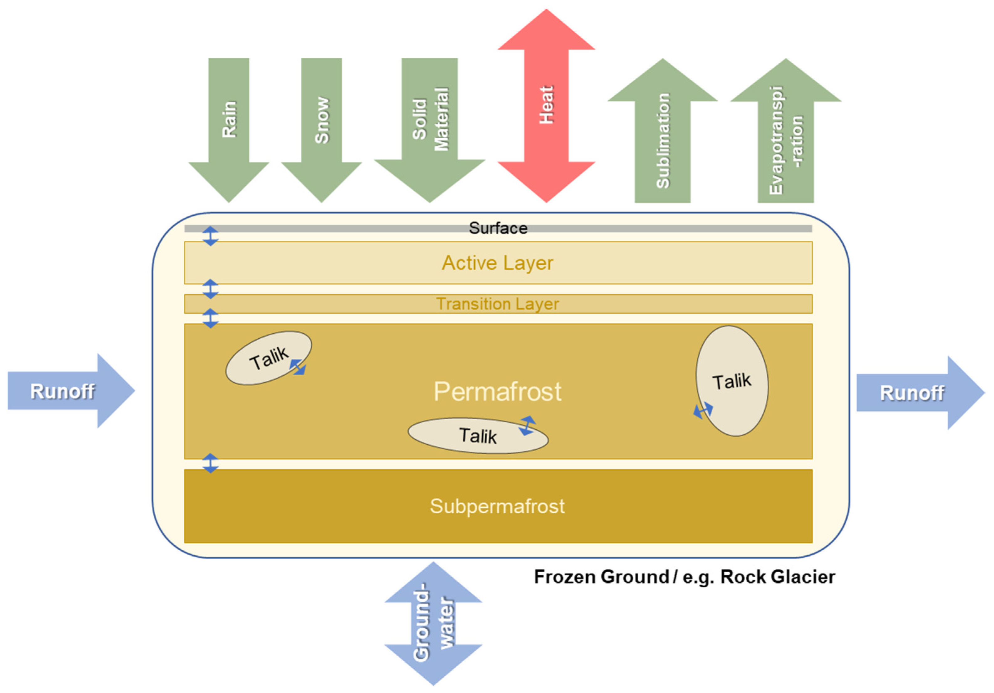
The complex interaction between a permafrost body and various hydrological components that play into the overall water balance of a permafrost dominated mountain watershed is summarized in Figure 13. The specific geomorphological origin of the frozen ground that constitutes the permafrost body is irrelevant since the physical processes are similar. The thickness and the volumetric ice content of a rock glacier may be larger than that of a frozen talus slope, but this, if changes in the atmospheric conditions are equal, simply reduces the permafrost degradation rate in the rock glacier in response to the differences in the latent heat stored within the permafrost body. The schematic presented further suggests that credible conclusions regarding current or future hydrological conditions, such as future hydrograph projections, should only be made if surface water runoff, precipitation, sublimation rates, evaporation rates, and groundwater flows are recorded individually, and a thorough understanding of the hydrological regime is developed.
In conclusion, frozen ground within a mountain permafrost environment should be considered as hydrogeologic units that store and transmit water depending on their hydrological and thermal characteristics, either from direct recharge; for example, within the footprint of a rock glacier, or from runoff; for example, groundwater entering from contributing basins and flowing through a cryoform that is then discharged downstream. The hydrologic importance of mountain permafrost is primarily in the way that it modulates water input signals into discharge signals and the environmental effects of their discharge, the same as other coarse-grained hydrogeologic units in mountainous regions. It does not matter if rock glaciers or other specific periglacial cryoforms that can be identified and categorized are present within a mountain watershed or not. Of essence is the amount and distribution of ground ice and the ability to transmit water when released. Focusing on rock glaciers, simply because they are recognizable, offers a biased view of the watershed or the regional hydrology and may underestimate how much ground ice is present within a watershed.
Despite the growing interest and need in understanding mountain permafrost hydrology in arid regions around the world, and specifically the Dry Andes, there are few studies available to date that have investigated the major processes controlling discharge in detail, and its hydrological behaviour appears to vary with geology, morphology, and permafrost conditions. In addition, most of the studies available to date have focused on rock glaciers, causing a bias towards one specific landform. Thus, additional studies applying in situ characterization, long-term monitoring, and numerical modelling techniques should be conducted to determine the hydrologic behaviour and water contribution of melting ground ice in response to permafrost degradation, hence climate change. Such studies are complex, require continuous data collection for multiple years and a multi-disciplinary approach, but must be favoured over investigations that are short, selective, and lacking a holistic view. However, recent progress in environmental monitoring, remote sensing, and numerical modelling allows for improving the quality and the quantity of data that can be used in the calibration and validation of numerical models. Such studies can subsequently assist in modelling the current and projected role of permafrost within mountainous environments, including shedding light on the discussions around the role of rock glaciers within watersheds of arid mountain regions. Nevertheless, ground ice volumes and permafrost extents cannot be delineated precisely and, therefore, assumptions and approximations must always be used, complicating estimations of runoff in response to climate change.
Author Contributions
Conceptualization, L.U.A., J.S.H. and C.E.M.K.; methodology, L.U.A. and J.S.H.; resources, L.U.A., J.S.H. and C.E.M.K.; writing—original draft preparation, L.U.A., J.S.H. and C.E.M.K.; writing—review and editing, L.U.A., J.S.H., C.E.M.K. and P.A.W.; visualization, L.U.A.; supervision, L.U.A. All authors have read and agreed to the published version of the manuscript.
Funding
This review was completed without external funding.
Data Availability Statement
No new data were created or analyzed in this study. Data sharing is not applicable to this article.
Acknowledgments
The authors are grateful for the multiple opportunities they had working on various projects within mountain permafrost regions around the world that allowed to appreciate the beauty of these environments and grow the understanding used for writing this review. We also wish to thank Lynn Forrest for her seemingly tireless quest for references that were critical when preparing the manuscript. Finally, the authors appreciate the comments from two anonymous reviewers on an earlier draft of the paper that resulted in substantial improvements.
Conflicts of Interest
The authors declare no conflict of interest.
References
- Hock, R.; Rasul, G.; Adler, C.; Cáceres, B.; Gruber, S.; Hirabayashi, Y.; Jackson, M.; Kääb, A.; Kang, S.; Kutuzov, S.; et al. High Mountain Areas. In IPCC Special Report on the Ocean and Cryosphere in a Changing Climate; Masson-Delmotte, V., Zhai, P., Pirani, A., Connors, S.L., Péan, C., Berger, S., Caud, N., Chen, Y., Goldfarb, L., Gomis, M.I., et al., Eds.; IPCC: Geneva, Switzerland, 2019; pp. 131–202. [Google Scholar]
- IPCC. Climate Change 2021: The Physical Science Basis. Contribution of Working Group I to the Sixth Assessment Report of the Intergovernmental Panel on Climate Change; Masson-Delmotte, V., et al., Eds.; IPCC: Geneva, Switzerland, 2021. [Google Scholar]
- Ferri, L.; Dussaillant, I.; Zalazar, L.; Masiokas, M.H.; Ruiz, L.; Pitte, P.; Gargantini, H.; Castro, M.; Berthier, E.; Villalba, R. Ice mass loss in the Central Andes of Argentina between 2000 and 2018 derived from a new glacier inventory and satellite stereo-imagery. Front. Earth Sci. 2020, 8, 530997. [Google Scholar] [CrossRef]
- Dussaillant, I.; Berthier, E.; Brun, F.; Masiokas, M.; Hugonnet, R.; Favier, V.; Rabatel, A.; Pitte, P.; Ruiz, L. Two decades of glacier mass loss along the Andes. Nat. Geosci. 2019, 12, 802–808. [Google Scholar] [CrossRef]
- World Glacier Monitoring Service (WGMS). Fluctuations of Glaciers (FoG) Database; World Glacier Monitoring Service: Zurich, Switzerland, 2021. [Google Scholar] [CrossRef]
- Haeberli, W.; Schaub, Y.; Huggel, C. Increasing risks related to landslides from degrading permafrost into new lakes in de-glaciating mountain ranges. Geomorphology 2017, 293, 405–417. [Google Scholar] [CrossRef]
- Lachenbruch, A.H.; Marshall, B.V. Changing climate: Geothermal evidence from permafrost in the alaskan arctic. Science 1986, 234, 689–696. [Google Scholar] [CrossRef] [PubMed]
- Jakob, M. Landslides in a changing climate. In Landslide Hazards, Risks, and Disasters; Shroder, J.F., Ed.; Elsevier Inc.: Amsterdam, The Netherlands, 2022. [Google Scholar]
- Arenson, L.U.; Jakob, M. Periglacial geohazard risks and ground temperature increases. In Engineering Geology for Society and Territory-Volume 1; Springer: Berlin/Heidelberg, Germany, 2015; pp. 233–237. [Google Scholar]
- Kenner, R.; Arenson, L.U.; Grämiger, L. Mass movement processes related to permafrost and glaciation. In Reference Module in Earth Systems and Environmental Sciences; Elsevier: Amsterdam, The Netherlands, 2021. [Google Scholar]
- Krainer, K.; Bressan, D.; Dietre, B.; Haas, J.N.; Hajdas, I.; Lang, K.; Mair, V.; Nickus, U.; Reidl, D.; Thies, H.; et al. A 10,300-year-old permafrost core from the active rock glacier Lazaun, southern Ötztal Alps (South Tyrol, northern Italy). Quat. Res. 2015, 83, 324–335. [Google Scholar] [CrossRef]
- Haeberli, W.; Kääb, A.; Wagner, S.; Mühll, D.V.; Geissler, P.; Haas, J.N.; Glatzel-Mattheier, H.; Wagenbach, D. Pollen analysis and 14C age of moss remains in a permafrost core recovered from the active rock glacier Murtèl-Corvatsch, Swiss Alps: Geomorphological and glaciological implications. J. Glaciol. 1999, 45, 1–8. [Google Scholar] [CrossRef]
- Hendriks, M. Introduction to Physical Hydrology; Oxford University Press: Oxford, UK, 2010; p. 304. [Google Scholar]
- Ayala, A.; Pellicciotti, F.; Peleg, N.; Burlando, P. Melt and surface sublimation across a glacier in a dry environment: Distributed energy-balance modelling of Juncal Norte Glacier, Chile. J. Glaciol. 2017, 63, 803–822. [Google Scholar] [CrossRef] [Green Version]
- Voordendag, A.; Réveillet, M.; MacDonell, S.; Lhermitte, S. Snow model comparison to simulate snow depth evolution and sublimation at point scale in the semi-arid Andes of Chile. Cryosphere 2021, 15, 4241–4259. [Google Scholar] [CrossRef]
- Walvoord, M.A.; Kurylyk, B.L. Hydrologic impacts of thawing permafrost-A review. Vadose Zone J. 2016, 15, vzj10. [Google Scholar] [CrossRef]
- Rogger, M.; Chirico, G.B.; Hausmann, H.; Krainer, K.; Brückl, E.; Stadler, P.; Blöschl, G. Impact of mountain permafrost on flow path and runoff response in a high alpine catchment. Water Resour. Res. 2017, 53, 1288–1308. [Google Scholar] [CrossRef] [Green Version]
- Arenson, L.U.; Jakob, M. The significance of rock glaciers in the dry Andes-A discussion of Azócar and Brenning (2010) and Brenning and Azócar (2010). Permafr. Periglac. Process. 2010, 21, 282–285. [Google Scholar] [CrossRef]
- Lemke, P.; Ren, J.; Alley, R.B.; Allison, I.; Carrasco, J.; Flato, G.; Fujii, Y.; Kaser, G.; Mote, P.; Thomas, R.H.; et al. Observations: Changes in snow, ice and frozen ground. In Climate Change 2007: The Physical Science Basis; Cambridge University Press: Cambridge, UK, 2007; p. 48. [Google Scholar]
- Singh, P.; Singh, V.P. Snow and glacier hydrology. In Water Science and Technology Library; Springer: Amsterdam, The Netherlands, 2002. [Google Scholar]
- Irvine-Fynn, T.; Hubbard, B. Glacier hydrology and runoff. In International Encyclopedia of Geography: People, the Earth, Environment and Technology; Wiley & Sons: Hoboken, NJ, USA, 2017; pp. 1–18. [Google Scholar]
- Irvine-Fynn, T.D.; Hodson, A.J.; Moorman, B.J.; Vatne, G.; Hubbard, A.L. Polythermal glacier hydrology: A review. Rev. Geophys. 2011, 49, 37. [Google Scholar] [CrossRef] [Green Version]
- Noetzli, J.; Phillips, M. Mountain Permafrost Hydrology; WSL Institute for Snow and Avalanche Research SLF: Davos, Switzerland, 2019; p. 18. [Google Scholar]
- Jones, D.B.; Harrison, S.; Anderson, K.; Betts, R.A. Mountain rock glaciers contain globally significant water stores. Sci. Rep. 2018, 8, 2834. [Google Scholar] [CrossRef] [PubMed] [Green Version]
- Bodin, X.; Rojas, F.; Brenning, A. Status and evolution of the cryosphere in the Andes of Santiago (Chile, 33.5° S). Geomorphology 2010, 118, 453–464. [Google Scholar] [CrossRef]
- Vicuña, S.; Vargas, X.; Boisier, J.P.; Mendoza, P.A.; Gómez, T.; Vásquez, N. Impacts of climate change on water resources in Chile. In Water Resources of Chile; Springer: Berlin/Heidelberg, Germany, 2021; pp. 347–363. [Google Scholar]
- Falaschi, D.; Castro, M.; Masiokas, M.; Tadono, T.; Ahumada, A.L. Rock glacier inventory of the Valles Calchaquíes Region (~25° S), Salta, Argentina, Derived from ALOS Data. Permafr. Perigl. Process. 2014, 25, 69–75. [Google Scholar] [CrossRef]
- Gao, H.; Wang, J.; Yang, Y.; Pan, X.; Ding, Y.; Duan, Z. Permafrost hydrology of the Qinghai-Tibet Plateau: A review of processes and modeling. Front. Earth Sci. 2021, 8, 576838. [Google Scholar] [CrossRef]
- Schaffer, N.; MacDonell, S.; Réveillet, M.; Yáñez, E.; Valois, R. Rock glaciers as a water resource in a changing climate in the semiarid Chilean Andes. Reg. Environ. Chang. 2019, 19, 1263–1279. [Google Scholar] [CrossRef]
- van Everdingen, R.O. Multi-Language Glossary of Permafrost and Related Ground-Ice Terms (Revised 2005); International Permafrost Association: Ottawa, ON, Canada, 1998. [Google Scholar]
- Dingman, S.L. Physical Hydrology, 2nd ed.; Pearson: London, UK, 2001; p. 656. [Google Scholar]
- Muller, S.W. Permafrost, or Permanently Frozen Ground and Related Engineering Problems; J.W. Edward Publication: Ann Arbour, MI, USA, 1947. [Google Scholar]
- Woo, M.-K. Permafrost Hydrology, 1st ed.; Springer: Berlin/Heidelberg, Germany, 2012; p. 564. [Google Scholar]
- Gruber, S. Derivation and analysis of a high-resolution estimate of global permafrost zonation. Cryosphere 2012, 6, 221–233. [Google Scholar] [CrossRef] [Green Version]
- Baker, H.S.; Millar, R.J.; Karoly, D.J.; Beyerle, U.; Guillod, B.P.; Mitchell, D.; Shiogama, H.; Sparrow, S.; Woollings, T.; Allen, M.R. Higher CO2 concentrations increase extreme event risk in a 1.5 °C world. Nat. Clim. Chang. 2018, 8, 604–608. [Google Scholar] [CrossRef] [Green Version]
- Williams, J.R.; van Everdingen, R.O. Groundwater Investigations in Permafrost Regions of North America: A Review. In Proceedings of the Second International Conference on Permafrost, Yakutsk, Russia, 20–24 June 1973; pp. 435–446. [Google Scholar]
- Dingman, S.L. Hydrologic Effects of Frozen Ground: Literature Review and Synthesis; U.S. Army Cold Regions Research and Engineering Laboratory: Washington, DC, USA, 1975. [Google Scholar]
- Woo, M.-K.; Kane, D.L.; Carey, S.K.; Yang, D. Progress in permafrost hydrology in the new millennium. Permafr. Perigl. Process. 2008, 19, 237–254. [Google Scholar] [CrossRef]
- Fredlund, D.G.; Rahardjo, H.; Fredlund, M.D. Unsaturated Soil Mechanics in Engineering Practice; Wiley: Hoboken, NJ, USA, 2012; p. 944. [Google Scholar]
- McPhee, J.; MacDonell, S.; Casassa, G. Snow Cover and Glaciers, in Water Resources of Chile; Springer: Berlin/Heidelberg, Germany, 2021; pp. 129–151. [Google Scholar]
- Baselt, I.; Heinze, T. Rain, snow and frozen soil: Open questions from a porescale perspective with implications for geohazards. Geosciences 2021, 11, 375. [Google Scholar] [CrossRef]
- Haeberli, W.; Whiteman, C. Snow and Ice-Related Hazards, Risks, and Disasters, 2nd ed.; Schroder, J.F.S., Jr., Ed.; Elsevier: Amsterdam, The Netherlands, 2021; p. 784. [Google Scholar]
- Andersland, O.B.; Ladanyi, B. Frozen Ground Engineering, 2nd ed.; Wiley: Hoboken, NJ, USA, 2003; p. 384. [Google Scholar]
- Prowse, T.D.; Ommanney, C.S.L. Northern Hydrology: Canadian Perspectives; National Hydrology Research Institute: Saskatoon, ON, Canada, 1990; p. 308. [Google Scholar]
- Burt, T.P.; Williams, P.J. Hydraulic conductivity in frozen soils. Earth Surf. Process. 1976, 1, 349–360. [Google Scholar] [CrossRef]
- Azmatch, T.F.; Sego, D.C.; Arenson, L.U.; Biggar, K.W. Using soil freezing characteristic curve to estimate the hydraulic conductivity function of partially frozen soils. Cold Reg. Sci. Technol. 2012, 83–84, 103–109. [Google Scholar] [CrossRef]
- Kane, D.L.; Yoshikawa, K.; McNamara, J.P. Regional groundwater flow in an area mapped as continuous permafrost, NE Alaska (USA). Hydrogeol. J. 2013, 21, 41–52. [Google Scholar] [CrossRef]
- Arenson, L.; Colgan, W.; Marshall, H.P. Physical, thermal, and mechanical properties of snow, ice, and permafrost. In Snow and Ice-Related Hazards, Risks, and Disasters; Elsevier: Amsterdam, The Netherlands, 2021; pp. 35–71. [Google Scholar]
- Hivon, E.G.; Sego, D.C. Distribution of saline permafrost in the Northwest Territories, Canada. Can. Geotechn. J. 1993, 30, 506–514. [Google Scholar] [CrossRef]
- Arenson, L.U.; Sego, D.C. The effect of salinity on the freezing of coarse-grained sands. Can. Geotechn. J. 2006, 43, 325–337. [Google Scholar] [CrossRef]
- Brown, R.J.E. Distribution and environmental relationships of permafrost. In Permafrost Hydrology Workshop Seminar: The International Hydrological Decade; Canadian National Committee: Ottawa, ON, Canada, 1974. [Google Scholar]
- French, H.M. The Periglacial Environment, 4th ed.; Wiley-Blackwell: London, UK, 2017. [Google Scholar]
- Cheng, G.; Jin, H. Permafrost and groundwater on the Qinghai-Tibet Plateau and in northeast China. Hydrogeol. J. 2012, 21, 5–23. [Google Scholar] [CrossRef]
- Harrington, J.S.; Mozil, A.; Hayashi, M.; Bentley, L.R. Groundwater flow and storage processes in an inactive rock glacier. Hydrol. Process. 2018, 32, 3070–3088. [Google Scholar] [CrossRef]
- Lemieux, J.-M.; Fortier, R.; Murray, R.; Dagenais, S.; Cochand, M.; Delottier, H.; Therrien, R.; Molson, J.; Pryet, A.; Parhizkar, M. Groundwater dynamics within a watershed in the discontinuous permafrost zone near Umiujaq (Nunavik, Canada). Hydrogeol. J. 2020, 28, 833–851. [Google Scholar] [CrossRef]
- Lemieux, J.-M.; Fortier, R.; Molson, J.; Therrien, R.; Ouellet, M. Topical Collection: Hydrogeology of a cold-region watershed near Umiujaq (Nunavik, Canada). Hydrogeol. J. 2020, 28, 809–812. [Google Scholar] [CrossRef] [Green Version]
- Gruber, S.; Egli, M.; Gärtner-roer, I.; Hoelzle, M. Preface: The mountain cryosphere-a holistic view on processes and their interactions. Geogr. Ann. Ser. A Phys. Geogr. Environ. Sustain. 2012, 94, 177–182. [Google Scholar] [CrossRef] [Green Version]
- Deluigi, N.; Lambiel, C.; Kanevski, M. Data-driven mapping of the potential mountain permafrost distribution. Sci. Total Environ. 2017, 590–591, 370–380. [Google Scholar] [CrossRef] [PubMed] [Green Version]
- Bonnaventure, P.P.; Hillaire-Marcel, C.; Lewkowicz, A.G. Mountain permafrost probability mapping using the BTS method in two climatically dissimilar locations, northwest Canada. Can. J. Earth Sci. 2008, 45, 443–455. [Google Scholar] [CrossRef]
- Lewkowicz, A.G.; Bonnaventure, P.P.; Smith, S.L.; Kuntz, Z. Spatial and thermal characteristics of mountain permafrost, northwest canada. Geogr. Ann. Ser. A Phys. Geogr. 2016, 94, 195–213. [Google Scholar] [CrossRef]
- Arenson, L.U.; Jakob, M. A New GIS Based Mountain Permafrost Distribution Model. In Proceedings of the 63rd GEO2010: Canadian Geotechnical Conference & 6th Canadian Permafrost Conference, Calgary, AB, Canada, 12–15 September 2010; pp. 452–458. [Google Scholar]
- Ruiz, L.; Liaudat, D.T. Mountain permafrost distribution in the Andes of Chubut. In Proceedings of the Tenth International Conference on Permafrost, Salekhard, Russia, 25–29 June 2012. [Google Scholar]
- Esper Angillieri, M.Y. Permafrost distribution map of San Juan Dry Andes (Argentina) based on rock glacier sites. J. S. Am. Earth Sci. 2017, 73, 42–49. [Google Scholar] [CrossRef]
- Obu, J. How much of the Earth’s surface is underlain by permafrost? J. Geophys. Res. Earth Surf. 2021, 126, 740. [Google Scholar] [CrossRef]
- Hayashi, M. Alpine hydrogeology: The critical role of groundwater in sourcing the headwaters of the world. Ground Water 2020, 58, 498–510. [Google Scholar] [CrossRef] [PubMed]
- Rist, A.; Phillips, M. First results of investigations on hydrothermal processes within the active layer above alpine permafrost in steep terrain. Nor. Geogr. Tidsskr.-Nor. J. Geogr. 2007, 59, 177–183. [Google Scholar] [CrossRef]
- Krautblatter, M.; Funk, D.; Günzel, F.K. Why permafrost rocks become unstable: A rock-ice-mechanical model in time and space. Earth Surf. Process. Landf. 2013, 38, 876–887. [Google Scholar] [CrossRef] [Green Version]
- Phillips, M.; Wolter, A.; Lüthi, R.; Amann, F.; Kenner, R.; Bühler, Y. Rock slope failure in a recently deglaciated permafrost rock wall at Piz Kesch (Eastern Swiss Alps), February 2014. Earth Surf. Process. Landf. 2017, 42, 426–438. [Google Scholar] [CrossRef]
- Colombo, N.; Salerno, F.; Gruber, S.; Freppaz, M.; Williams, M.; Fratianni, S.; Giardino, M. Review: Impacts of permafrost degradation on inorganic chemistry of surface fresh water. Glob. Planet. Chang. 2018, 162, 69–83. [Google Scholar] [CrossRef]
- Biskaborn, B.K.; Smith, S.L.; Noetzli, J.; Matthes, H.; Vieira, G.; Streletskiy, D.A.; Schoeneich, P.; Romanovsky, V.E.; Lewkowicz, A.G.; Abramov, A.; et al. Permafrost is warming at a global scale. Nat. Commun. 2019, 10, 264. [Google Scholar] [CrossRef] [PubMed] [Green Version]
- Walter, F.; Amann, F.; Kos, A.; Kenner, R.; Phillips, M.; de Preux, A.; Huss, M.; Tognacca, C.; Clinton, J.; Diehl, T.; et al. Direct observations of a three million cubic meter rock-slope collapse with almost immediate initiation of ensuing debris flows. Geomorphology 2020, 351, 106933. [Google Scholar] [CrossRef]
- Krainer, K.; Mostler, W. Hydrology of active rock glaciers: Examples from the Austrian Alps. Arct. Antarct. Alp. Res. 2002, 34, 142–149. [Google Scholar] [CrossRef]
- Ireson, A.M.; Van Der Kamp, G.; Ferguson, G.; Nachshon, U.; Wheater, H.S. Hydrogeological processes in seasonally frozen northern latitudes: Understanding, gaps and challenges. Hydrogeol. J. 2013, 21, 53–66. [Google Scholar] [CrossRef]
- Frampton, A.; Painter, S.L.; Destouni, G. Permafrost degradation and subsurface-flow changes caused by surface warming trends. Hydrogeol. J. 2012, 21, 271–280. [Google Scholar] [CrossRef]
- Pomeroy, J.W. Book review: Snow and glacier hydrology. Mt. Res. Dev. 2002, 22, 307–308. [Google Scholar] [CrossRef]
- Jones, D.B.; Harrison, S.; Anderson, K.; Whalley, W.B. Rock glaciers and mountain hydrology: A review. Earth-Sci. Rev. 2019, 193, 66–90. [Google Scholar] [CrossRef]
- Croce, F.A.; Milana, J.P. Internal structure and behaviour of a rock glacier in the Arid Andes of Argentina. Permafr. Perigl. Process. 2002, 13, 289–299. [Google Scholar] [CrossRef]
- Brenning, A. Geomorphological, hydrological and climatic significance of rock glaciers in the Andes of Central Chile (33–35° S). Permafr. Perigl. Process. 2005, 16, 231–240. [Google Scholar] [CrossRef]
- Azócar, G.F.; Brenning, A. Hydrological and geomorphological significance of rock glaciers in the dry Andes, Chile (27–33° S). Permafr. Perigl. Process. 2010, 21, 42–53. [Google Scholar] [CrossRef]
- Bolch, T.; Marchenko, S. Significance of glaciers, rockglaciers, and ice-rich permafrost in the Northern Tien Shan as water towers under climate change conditions. In Assessment of Snow, Glacier and Water Resources in Asia: Selected Papers from the Workshop in Almaty, Kazakhstan, 2006; Braun, L.N., Hagg, W., Severskiy, I.V., Young, G., Eds.; IHP UNESCO: Koblenz, Germany, 2009; pp. 132–143. [Google Scholar]
- Reato, A.; Carol, E.S.; Cottescu, A.; Martínez, O.A. Hydrological significance of rock glaciers and other periglacial landforms as sustenance of wet meadows in the Patagonian Andes. J. S. Am. Earth Sci. 2021, 111, 103471. [Google Scholar] [CrossRef]
- Halla, C.; Blöthe, J.H.; Tapia Baldis, C.; Trombotto Liaudat, D.; Hilbich, C.; Hauck, C.; Schrott, L. Ice content and interannual water storage changes of an active rock glacier in the dry Andes of Argentina. Cryosphere 2021, 15, 1187–1213. [Google Scholar] [CrossRef]
- Perucca, L.; Angillieri, M.Y.E. Glaciers and rock glaciers’ distribution at 28° SL, Dry Andes of Argentina, and some considerations about their hydrological significance. Environ. Earth Sci. 2011, 64, 2079–2089. [Google Scholar] [CrossRef]
- Rangecroft, S.; Harrison, S.; Anderson, K. Rock glaciers as water stores in the Bolivian Andes: An assessment of their hydrological importance. Arct. Antarct. Alp. Res. 2018, 47, 89–98. [Google Scholar] [CrossRef] [Green Version]
- Villarroel, C.D.; Ortiz, D.A.; Forte, A.P.; Tamburini Beliveau, G.; Ponce, D.; Imhof, A.; López, A. Internal structure of a large, complex rock glacier and its significance in hydrological and dynamic behavior: A case study in the semi-arid Andes of Argentina. Permafr. Perigl. Process. 2022. Available online: https://0-onlinelibrary-wiley-com.brum.beds.ac.uk/doi/abs/10.1002/ppp.2132 (accessed on 12 November 2021).
- Jones, D.B.; Harrison, S.; Anderson, K.; Selley, H.L.; Wood, J.L.; Betts, R.A. The distribution and hydrological significance of rock glaciers in the Nepalese Himalaya. Glob. Planet. Chang. 2018, 160, 123–142. [Google Scholar] [CrossRef] [Green Version]
- Jones, D.B.; Harrison, S.; Anderson, K.; Shannon, S.; Betts, R.A. Rock glaciers represent hidden water stores in the Himalaya. Sci. Total Environ. 2021, 793, 145368. [Google Scholar] [CrossRef]
- Springman, S.M.; Arenson, L.U.; Yamamoto, Y.; Maurer, H.; Kos, A.; Buchli, T.; Derungs, G. Multidisciplinary investigations on three rock glaciers in the Swiss Alps: Legacies and future perspectives. Geogr. Ann. Ser. A Phys. Geogr. 2012, 94, 215–243. [Google Scholar] [CrossRef]
- Barsch, D. Rockglaciers-Indicators for the Present and Former Geoecology in High Mountain Environments; Springer: Berlin/Heidelberg, Germany, 1996. [Google Scholar]
- Kääb, A.; Reichmuth, T. Advance mechanisms of rock glaciers. Permafr. Perigl. Process. 2005, 16, 187–193. [Google Scholar] [CrossRef]
- Berthling, I. Beyond confusion: Rock glaciers as cryo-conditioned landforms. Geomorphology 2011, 131, 98–106. [Google Scholar] [CrossRef]
- Knight, J.; Harrison, S.; Jones, D.B. Rock glaciers and the geomorphological evolution of deglacierizing mountains. Geomorphology 2019, 324, 14–24. [Google Scholar] [CrossRef]
- Wahrhaftig, C.; Cox, A. Rock Glaciers in the Alaska Range. Geol. Soc. Am. Bull. 1959, 70, 383–436. [Google Scholar] [CrossRef]
- Tyrrell, J.B. Rock glaciers or chrystocrenes. J. Geol. 1910, 18, 549–553. [Google Scholar] [CrossRef] [Green Version]
- Capps, S.R., Jr. Rock glaciers in Alaska. J. Geol. 1910, 18, 359–375. [Google Scholar] [CrossRef]
- Wagner, T.; Kainz, S.; Krainer, K.; Winkler, G. Storage-discharge characteristics of an active rock glacier catchment in the Innere Ölgrube, Austrian Alps. Hydrol. Process. 2021, 35, 1–16. [Google Scholar] [CrossRef]
- Krainer, K.; Mostler, W.; Spötl, C. Discharge from active rock glaciers, Austrian Alps: A stable isotope approach. Aust. J. Earth Sci. 2007, 100, 102–112. [Google Scholar]
- Wagner, T.; Kainz, S.; Helfricht, K.; Fischer, A.; Avian, M.; Krainer, K.; Winkler, G. Assessment of liquid and solid water storage in rock glaciers versus glacier ice in the Austrian Alps. Sci. Total Environ. 2021, 800, 149593. [Google Scholar] [CrossRef]
- Tenthorey, G. Hydrologie liee aux glaciers rocheux, Haut-Val De Rechy (Nax, VS). Bull. Murithienne 1994, 112, 97–116. [Google Scholar]
- Mewes, B.; Hilbich, C.; Delaloye, R.; Hauck, C. Resolution capacity of geophysical monitoring regarding permafrost degradation induced by hydrological processes. Cryosphere 2017, 11, 2957–2974. [Google Scholar] [CrossRef] [Green Version]
- Harrington, J.S.; Hayashi, M.; Kurylyk, B.L. Influence of a rock glacier spring on the stream energy budget and cold-water refuge in an alpine stream. Hydrol. Process. 2017, 31, 4719–4733. [Google Scholar] [CrossRef]
- Arenson, L.U.; Jakob, M.; Wainstein, P. Hydrological contribution from degrading permafrost and rock glaciers in the northern Argentinian Andes. In Mine Water Solutions in Extreme Environments; InfoMine: Lima, Peru, 2013. [Google Scholar]
- PERMOS. Swiss Permafrost Bulletin 2019/2020; Noetzli, J., Pellet, C., Eds.; PERMOS: Zurich, Switzerland, 2021; p. 21. [Google Scholar]
- Haeberli, W.; Hoelzle, M.; Kääb, A.; Keller, F.; Vonder Mühll, D.; Wagner, S. Ten Years after Drilling through the Permafrost of the Active Rock Glacier Murtèl, Eastern Swiss Alps: Answered Questions and New Perspectives. In Proceedings of the 7th International Conference on Permafrost; Centre d’Études Nordiques Sainte-Foy: Yellowknife, NT, Canada, 1998; Volume 57, pp. 403–410. [Google Scholar]
- Arenson, L.; Hoelzle, M.; Springman, S. Borehole deformation measurements and internal structure of some rock glaciers in Switzerland. Permafr. Perigl. Process. 2002, 13, 117–135. [Google Scholar] [CrossRef]
- Vonder Mühll, D.S.; Holub, P. Borehole logging in alpine permafrost, upper Engadin, Swiss Alps. Permafr. Perigl. Process. 1992, 3, 125–132. [Google Scholar] [CrossRef]
- Kellerer-Pirklbauer, A.; Rieckh, M. Monitoring nourishment processes in the rooting zone of an active rock glacier in an alpine environment. Zeitschr. Geomorphol. Suppl. Issues 2016, 60, 99–121. [Google Scholar] [CrossRef]
- Benn, D.; Evans, D.J. Glaciers and Glaciation; Routledge: London, UK, 2014. [Google Scholar]
- Kummert, M.; Bodin, X.; Braillard, L.; Delaloye, R. Pluri-decadal evolution of rock glaciers surface velocity and its impact on sediment export rates towards high alpine torrents. Earth Surf. Process. Landf. 2021, 46, 3213–3227. [Google Scholar] [CrossRef]
- Rock Glacier Inventories and Kinematics (RGIK). Towards Standard Guidelines for Inventorying Rock Glaciers. Baseline Concepts (Version 4.2.1); Barboux, C., Delaloye, R., Pellet, C., Eds.; IPA Action Group Rock Glacier Inventories and Kinematics: Fribourg, Switzerland, 2021; p. 13. [Google Scholar]
- Duguay, M.A.; Edmunds, A.; Arenson, L.U.; Wainstein, P.A. Quantifying the significance of the hydrological contribution of a rock glacier–A review. In Proceedings of the 68th Canadian Geotechnical Conference and 7th Canadian Permafrost Conference (GeoQuébec 2015); Canadian Geotechnical Society: Richmond, BC, Canada, 2015; p. 8. [Google Scholar]
- Konrad, S.K.; Humphrey, N.F.; Steig, E.J.; Clark, D.H.; Potter, N., Jr.; Pfeffer, W.T. Rock glacier dynamics and paleoclimatic implications. Geology 1999, 27, 1131–1134. [Google Scholar] [CrossRef]
- Bodin, X.; Thibert, E.; Fabre, D.; Ribolini, A.; Schoeneich, P.; Francou, B.; Reynaud, L.; Fort, M. Two decades of responses (1986–2006) to climate by the Laurichard rock glacier, French Alps. Permafr. Perigl. Process. 2009, 20, 331–344. [Google Scholar] [CrossRef]
- Buchli, T.; Merz, K.; Zhou, X.; Kinzelbach, W.; Springman, S.M. Characterization and Monitoring of the Furggwanghorn Rock Glacier, Turtmann Valley, Switzerland: Results from 2010 to 2012. Vadose Zone J. 2013, 12, vzj067. [Google Scholar] [CrossRef] [Green Version]
- Sorg, A.; Kääb, A.; Roesch, A.; Bigler, C.; Stoffel, M. Contrasting responses of Central Asian rock glaciers to global warming. Sci. Rep. 2015, 5, 8228. [Google Scholar] [CrossRef] [Green Version]
- Scherler, M.; Hauck, C.; Hoelzle, M.; Salzmann, N. Modeled sensitivity of two alpine permafrost sites to RCM-based climate scenarios. J. Geophys. Res. Earth Surf. 2013, 118, 780–794. [Google Scholar] [CrossRef] [Green Version]
- Scherler, M.; Hauck, C.; Hoelzle, M.; Stähli, M.; Völksch, I. Meltwater infiltration into the frozen active layer at an alpine permafrost site. Permafr. Perigl. Process. 2010, 21, 325–334. [Google Scholar] [CrossRef] [Green Version]
- Delaloye, R.; Lambiel, C. Evidence of winter ascending air circulation throughout talus slopes and rock glaciers situated in the lower belt of alpine discontinuous permafrost (Swiss Alps). Nor. Geogr. Tidsskr.-Nor. J. Geogr. 2007, 59, 194–203. [Google Scholar] [CrossRef]
- Kenner, R.; Phillips, M.; Hauck, C.; Hilbich, C.; Mulsow, C.; Bühler, Y.; Stoffel, A.; Buchroithner, M. New insights on permafrost genesis and conservation in talus slopes based on observations at Flüelapass, Eastern Switzerland. Geomorphology 2017, 290, 101–113. [Google Scholar] [CrossRef]
- Lachenbruch, A.H.; Marshall, B.V. Heat flow in the Arctic. Arctic 1969, 22, 300–311. [Google Scholar] [CrossRef] [Green Version]
- Thies, H.; Nickus, U.; Tolotti, M.; Tessadri, R.; Krainer, K. Evidence of rock glacier melt impacts on water chemistry and diatoms in high mountain streams. Cold Reg. Sci. Technol. 2013, 96, 77–85. [Google Scholar] [CrossRef]
- Thies, H.; Nickus, U.; Mair, V.; Tessadri, R.; Tait, D.; Thaler, B.; Psenner, R. Unexpected response of high Alpine Lake waters to climate warming. Environ. Sci. Technol. 2007, 41, 7424–7429. [Google Scholar] [CrossRef]
- Nickus, U.; Krainer, K.; Thies, H.; Tolotti, M. Blockgletscherabflüsse im Äußeren Hochebenkar: Hydrologie, Wasserchemie und Kieselalgen; Innsbruck University: Innsbruck, Austria, 2015; pp. 117–134. [Google Scholar]
- Ilyashuk, B.P.; Ilyashuk, E.A.; Psenner, R.; Tessadri, R.; Koinig, K.A. Rock glacier outflows may adversely affect lakes: Lessons from the past and present of two neighboring water bodies in a crystalline-rock watershed. Environ. Sci. Technol. 2014, 48, 6192–6200. [Google Scholar] [CrossRef] [PubMed]
- Williams, M.W.; Knauf, M.; Caine, N.; Liu, F.; Verplanck, P.L. Geochemistry and source waters of rock glacier outflow, Colorado Front Range. Permafr. Perigl. Process. 2006, 17, 13–33. [Google Scholar] [CrossRef] [Green Version]
- Williams, M.W.; Knauf, M.; Cory, R.; Caine, N.; Liu, F. Nitrate content and potential microbial signature of rock glacier outflow, Colorado Front Range. Earth Surf. Process. Landf. 2007, 32, 1032–1047. [Google Scholar] [CrossRef]
- Wagner, T.; Brodacz, A.; Krainer, K.; Winkler, G. Active rock glaciers as shallow groundwater reservoirs, Austrian Alps. Grundwasser 2020, 25, 215–230. [Google Scholar] [CrossRef]
- Fegel, T.S.; Baron, J.S.; Fountain, A.G.; Johnson, G.F.; Hall, E.K. The differing biogeochemical and microbial signatures of glaciers and rock glaciers. J. Geophys. Res. Biogeosci. 2016, 121, 919–932. [Google Scholar] [CrossRef] [Green Version]
- Trombotto-Liaudat, D.; Sileo, N.; Dapeña, C. Periglacial water paths within a rock glacier-dominated catchment in the Stepanek area, Central Andes, Mendoza, Argentina. Permafr. Perigl. Process. 2020, 31, 311–323. [Google Scholar] [CrossRef]
- Millar, C.I.; Westfall, R.D.; Delany, D.L. Thermal and hydrologic attributes of rock glaciers and periglacial talus landforms: Sierra Nevada, California, USA. Quat. Int. 2013, 310, 169–180. [Google Scholar] [CrossRef]
- Geiger, S.T.; Daniels, J.M.; Miller, S.N.; Nicholas, J.W. Influence of rock glaciers on stream hydrology in the La Sal Mountains, Utah. Arct. Antarct. Alp. Res. 2018, 46, 645–658. [Google Scholar] [CrossRef] [Green Version]
- Winkler, G.; Wagner, T.; Pauritsch, M.; Birk, S.; Kellerer-Pirklbauer, A.; Benischke, R.; Leis, A.; Morawetz, R.; Schreilechner, M.G.; Hergarten, S. Identification and assessment of groundwater flow and storage components of the relict Schöneben Rock Glacier, Niedere Tauern Range, Eastern Alps (Austria). Hydrogeol. J. 2016, 24, 937–953. [Google Scholar] [CrossRef]
- Colombo, N.; Gruber, S.; Martin, M.; Malandrino, M.; Magnani, A.; Godone, D.; Freppaz, M.; Fratianni, S.; Salerno, F. Rainfall as primary driver of discharge and solute export from rock glaciers: The Col d’Olen Rock Glacier in the NW Italian Alps. Sci. Total Environ. 2018, 639, 316–330. [Google Scholar] [CrossRef] [PubMed]
- Colombo, N.; Ferronato, C.; Antisari, L.V.; Marziali, L.; Salerno, F.; Fratianni, S.; D’Amico, M.E.; Ribolini, A.; Godone, D.; Sartini, S.; et al. A rock-glacier–pond system (NW Italian Alps): Soil and sediment properties, geochemistry, and trace-metal bioavailability. Catena 2020, 194, 104700. [Google Scholar] [CrossRef]
- Cicoira, A.; Marcer, M.; Gärtner-Roer, I.; Bodin, X.; Arenson, L.U.; Vieli, A. A general theory of rock glacier creep based on in-situ and remote sensing observations. Permafr. Perigl. Process. 2020, 32, 139–153. [Google Scholar] [CrossRef]
- Springman, S.M.; Yamamoto, Y.; Buchli, T.; Hertrich, M.; Maurer, H.; Merz, K.; Gärtner-Roer, I.; Seward, L. Rock glacier degradation and instabilities in the European Alps: A characterisation and monitoring experiment in the Turtmanntal, CH. In Landslides Science and Practice; Margottini, C.P., Sassa, C.K., Eds.; Springer: Berlin/Heidelberg, Germany, 2013; pp. 5–13. [Google Scholar]
- Moyer, A.N.; Moore, R.D.; Koppes, M.N. Streamflow response to the rapid retreat of a lake-calving glacier. Hydrol. Process. 2016, 30, 3650–3665. [Google Scholar] [CrossRef]
- Bocchiola, D. Long term (1921–2011) hydrological regime of Alpine catchments in Northern Italy. Adv. Water Resour. 2014, 70, 51–64. [Google Scholar] [CrossRef]
- Bard, A.; Renard, B.; Lang, M.; Giuntoli, I.; Korck, J.; Koboltschnig, G.; Janža, M.; d’Amico, M.; Volken, D. Trends in the hydrologic regime of Alpine rivers. J. Hydrol. 2015, 529, 1823–1837. [Google Scholar] [CrossRef]
- Fleming, S.W.; Dahlke, H.E. Modulation of linear and nonlinear hydroclimatic dynamics by mountain glaciers in Canada and Norway: Results from information-theoretic polynomial selection. Can. Water Resour. J. 2014, 39, 324–341. [Google Scholar] [CrossRef] [Green Version]
- Mukhopadhyay, B.; Khan, A. Rising river flows and glacial mass balance in central Karakoram. J. Hydrol. 2014, 513, 192–203. [Google Scholar] [CrossRef]
- Duethmann, D.; Bolch, T.; Farinotti, D.; Kriegel, D.; Vorogushyn, S.; Merz, B.; Pieczonka, T.; Jiang, T.; Su, B.; Güntner, A. Attribution of streamflow trends in snow and glacier melt-dominated catchments of the Tarim River, Central Asia. Water Resour. Res. 2015, 51, 4727–4750. [Google Scholar] [CrossRef] [Green Version]
- Rientjes, T.H.M.; Reggiani, P. A reflection on the long-term water balance of the Upper Indus Basin. Hydrol. Res. 2015, 46, 446–462. [Google Scholar]
- Brahney, J.; Weber, F.; Foord, V.; Janmaat, J.; Curtis, P.J. Evidence for a climate-driven hydrologic regime shift in the Canadian Columbia Basin. Can. Water Resour. J. 2017, 42, 179–192. [Google Scholar] [CrossRef] [Green Version]
- Engelhardt, M.; Leclercq, P.; Eidhammer, T.; Kumar, P.; Landgren, O.; Rasmussen, R. Meltwater runoff in a changing climate (1951–2099) at Chhota Shigri Glacier, Western Himalaya, Northern India. Ann. Glaciol. 2017, 58 Pt 1, 47–58. [Google Scholar] [CrossRef] [Green Version]
- Wang, L.; Wang, F.; Li, Z.; Wang, W.; Li, H.; Wang, P. Glacier changes in the Sikeshu River basin, Tienshan Mountains. Quat. Int. 2015, 358, 153–159. [Google Scholar] [CrossRef]
- Beamer, J.P.; Hill, D.F.; Arendt, A.; Liston, G.E. High-resolution modeling of coastal freshwater discharge and glacier mass balance in the Gulf of Alaska watershed. Water Resour. Res. 2016, 52, 3888–3909. [Google Scholar] [CrossRef] [Green Version]
- Chen, Y.; Li, W.; Deng, H.; Fang, G.; Li, Z. Changes in Central Asia’s Water Tower: Past, Present and Future. Sci. Rep. 2016, 6, 35458. [Google Scholar] [CrossRef]
- Morse, P.D.; Burn, C.R.; Kokelj, S.V. Influence of snow on near-surface ground temperatures in upland and alluvial environments of the outer Mackenzie Delta, Northwest Territories. Can. J. Earth Sci. 2012, 49, 895–913. [Google Scholar] [CrossRef]
- Bernhard, L.; Sutter, F.; Haeberli, W.; Keller, F. Processes of snow/permafrost-interactions at a high-mountain site, Murtèl/Corvatsch, eastern Swiss Alps. In Proceedings of the 7th International Conference on Permafrost; Centre d’Études Nordiques: Yellowknife, NT, Canada; Université Laval Saint-Foy (Québec): Quebec, ON, Canada, 1998. [Google Scholar]
- Keller, F.; Gubler, H.U. Interaction between Snowcover and High Mountain Permafrost at Murtel/Corvatsch, Swiss Alps. In Proceedings of the Sixth International Conference on Permafrost, Beijing, China, 5–9 July 1993; pp. 332–337. [Google Scholar]
Figure 1.
Schematic illustrating possible changes in future surface (glacial) and ground (periglacial) ice volumes in non-polar mountain regions and the shifting influence of glacial and periglacial dynamics over time (after [6]). The rate at which this transition will occur likely varies substantially between mountain regions.

Figure 2.
Flow diagram, illustrating main water storages available withing the cryosphere and associated residence times (after [19]) from which water can contribute to runoff and how a drop of water may move through different storages. The green arrows indicate where water from surface discharge may flow back into a storage.

Figure 3.
Changes in ground temperature with time (Left) and associated temperature trumpet (Right), showing the minimum and maximum temperatures at each depth recorded during a year. The figure on the left illustrates how the thaw front in the spring and the freezing front in the fall penetrate from the surface, forming the active layer.

Figure 4.
Conceptual sketch for illustrating a simplified hydrograph showing the changes in contribution to water discharge in response to the freeze–thaw action within the active layer. If steady climate conditions exist, ground ice melt from permafrost thaw will not contribute, as there will be no permafrost degradation (Sketch by Derrill Shuttleworth).

Figure 5.
Soil percentage of unfrozen water content (a) and hydraulic conductivity (b) as a function or soil temperature. Modified from [45].
Figure 5.
Soil percentage of unfrozen water content (a) and hydraulic conductivity (b) as a function or soil temperature. Modified from [45].

Figure 6.
Dependency of the extent of mountain permafrost as a function of elevation and aspect for the southern hemisphere (not to scale). The inset shows different types of taliks that can be found in a permafrost environment and are relevant for water movement (after [45]).
Figure 6.
Dependency of the extent of mountain permafrost as a function of elevation and aspect for the southern hemisphere (not to scale). The inset shows different types of taliks that can be found in a permafrost environment and are relevant for water movement (after [45]).

Figure 7.
Rock glaciers from different mountain ranges illustrating the variety in the periglacial landforms. (1): Switzerland (lat: 46.150°/lon: 7.528°); (2): Metropolitan Region, Chile (lat: −33.227°/lon: −70.257°); (3): Yukon Territory, Canada (lat: 60.562°/lon: −137.239°; (4): Alberta, Canada (lat: 51.126°/lon: −115.629°). (Photos: L. Arenson).

Figure 8.
Illustrative example of a cryogenic rock glacier located in the province of La Rioja, Argentina (lat: −28.364°/lon: −69.544°). The rock glacier initiation was at the foot of a cirque, which provides the snow (via avalanche) and debris (via rockfall and debris flows) that constitutes the material of the landform. As this rock glacier advanced through creep (yellow dashed arrow) it crossed a stream, making it appear as if water originates from the rock glacier itself. However, the water that surfaces at the rock glacier front stems from the streams seen on the right and on the left (blue arrows) and flows through the sediments below the rock glacier before it resurfaces.

Figure 9.
Schematic on how temperature trumpets and permafrost thicknesses change in response to warmer atmospheric conditions. With increasing warming, a suprapermafrost talik may form as the annual frost penetration no longer reaches the permafrost table.
Figure 9.
Schematic on how temperature trumpets and permafrost thicknesses change in response to warmer atmospheric conditions. With increasing warming, a suprapermafrost talik may form as the annual frost penetration no longer reaches the permafrost table.

Figure 10.
Tri-directional (three different water paths) conceptual model of water flow in a rock glacier as proposed by [129]. The origin of the rock glacier, i.e., glacial or periglacial (see top illustrations), does not substantially influence the general conceptual model because the massive glacial ice body acts thermo-mechanically similar to the permafrost body. Sketches on rock glacier origin inspired by [76].

Figure 11.
(Left): Changes in ground temperatures over a period of 200 years assuming +3 °C warming per century, assuming mainly bedrock (after [6]). (Right): Schematic representation of the changes in permafrost distribution in mountain slopes containing ground ice (not to scale). Figure is illustrative for the northern hemisphere.

Figure 12.
Evolution of contributions from individual contributors of the cryosphere to total runoff in response to climate change. Figures is based on [1] with ground ice melt water contribution added by the authors. Time axis not to scale.
Figure 12.
Evolution of contributions from individual contributors of the cryosphere to total runoff in response to climate change. Figures is based on [1] with ground ice melt water contribution added by the authors. Time axis not to scale.

Figure 13.
Schematic illustration of the interaction between permafrost and relevant hydrological components.
Figure 13.
Schematic illustration of the interaction between permafrost and relevant hydrological components.

Publisher’s Note: MDPI stays neutral with regard to jurisdictional claims in published maps and institutional affiliations. |
© 2022 by the authors. Licensee MDPI, Basel, Switzerland. This article is an open access article distributed under the terms and conditions of the Creative Commons Attribution (CC BY) license (https://creativecommons.org/licenses/by/4.0/).
Share and Cite
MDPI and ACS Style
Arenson, L.U.; Harrington, J.S.; Koenig, C.E.M.; Wainstein, P.A. Mountain Permafrost Hydrology—A Practical Review Following Studies from the Andes. Geosciences 2022, 12, 48. https://0-doi-org.brum.beds.ac.uk/10.3390/geosciences12020048
AMA Style
Arenson LU, Harrington JS, Koenig CEM, Wainstein PA. Mountain Permafrost Hydrology—A Practical Review Following Studies from the Andes. Geosciences. 2022; 12(2):48. https://0-doi-org.brum.beds.ac.uk/10.3390/geosciences12020048
Chicago/Turabian StyleArenson, Lukas U., Jordan S. Harrington, Cassandra E. M. Koenig, and Pablo A. Wainstein. 2022. "Mountain Permafrost Hydrology—A Practical Review Following Studies from the Andes" Geosciences 12, no. 2: 48. https://0-doi-org.brum.beds.ac.uk/10.3390/geosciences12020048
Note that from the first issue of 2016, this journal uses article numbers instead of page numbers. See further details here.