
Geoheritage of the Monchegorsk Igneous Layered Paleoproterozoic Intrusion (Kola Peninsula, Arctic Russia): Evaluation and Geotourism Opportunities


Abstract
:1. Introduction
2. Geographical and Geological Settings
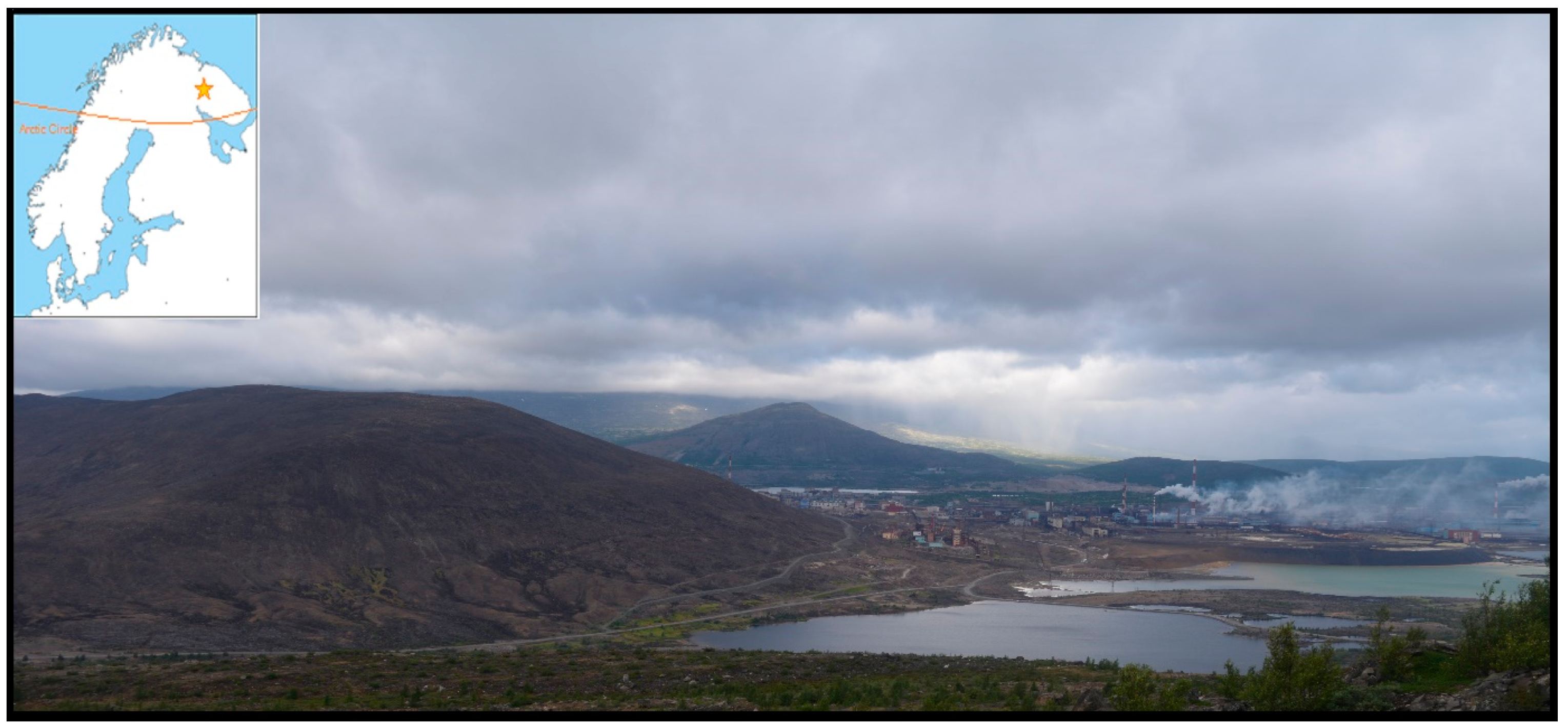
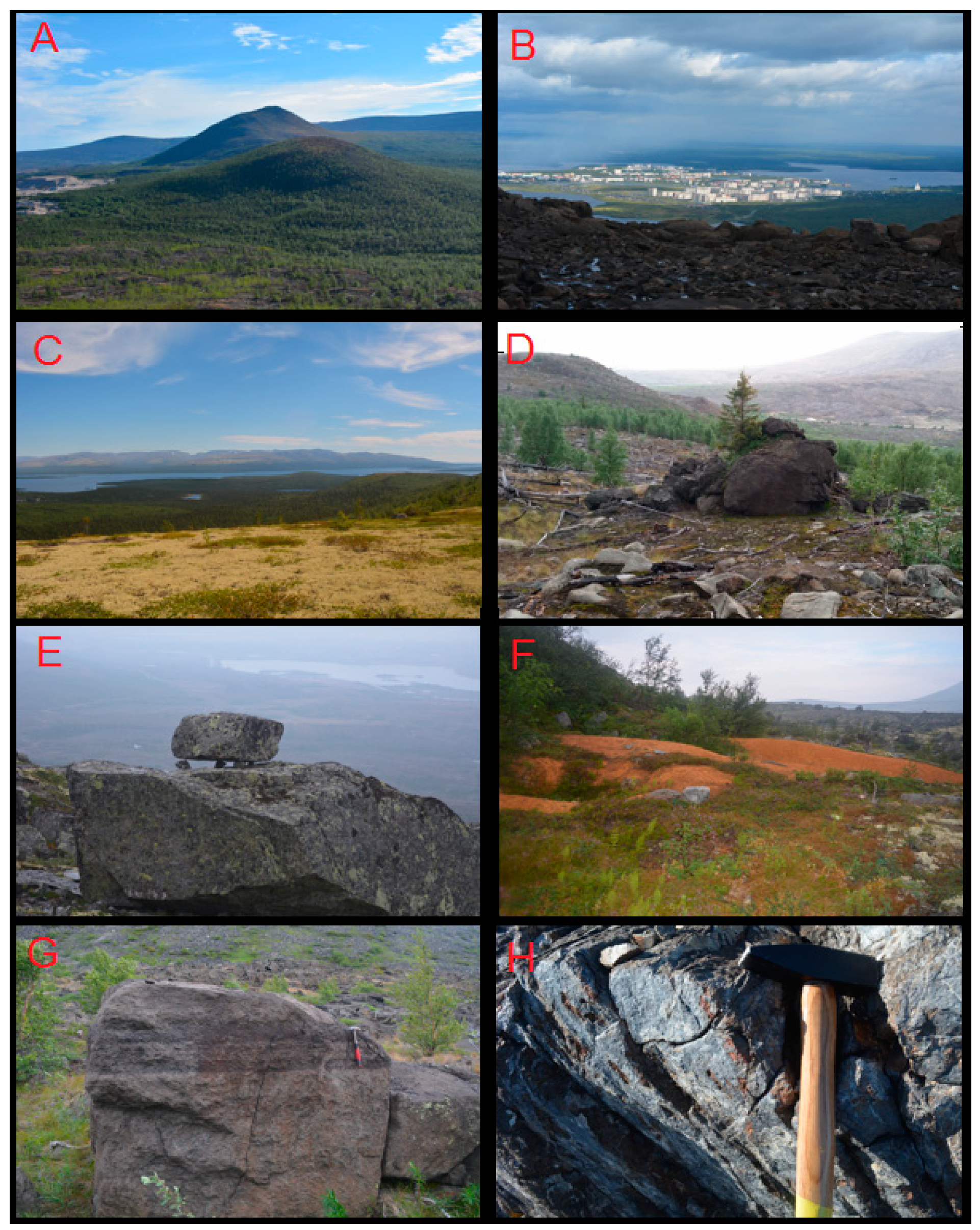
2.1. Geomorphological Characteristics
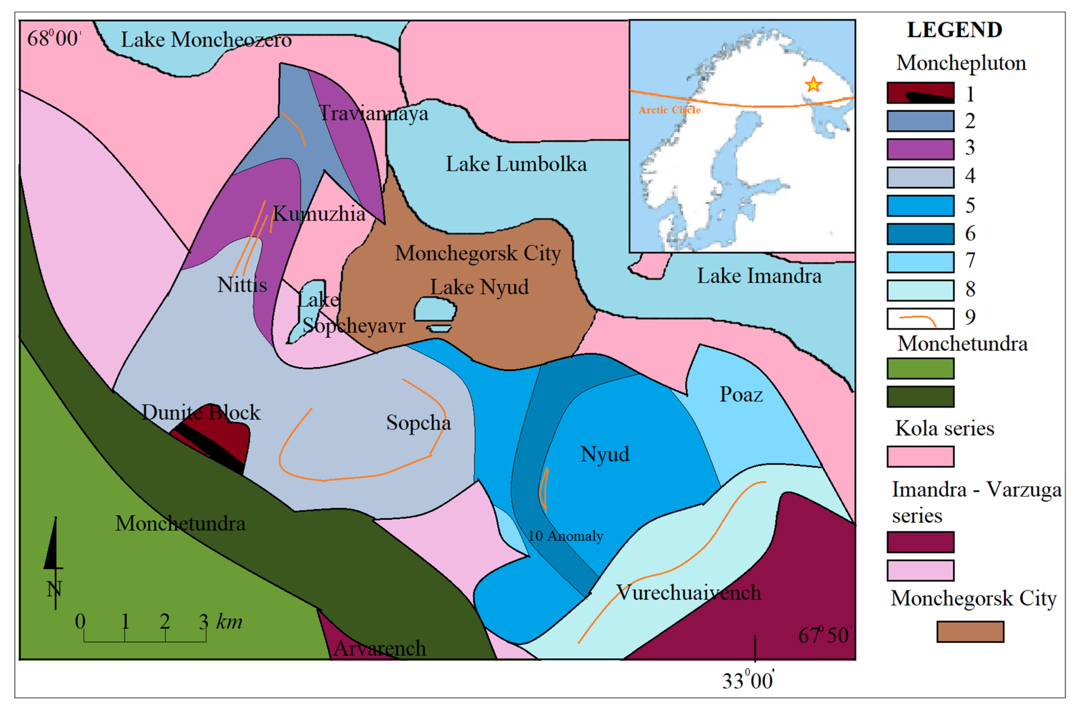
2.2. Characteristics of the Geological Structure of the Massif
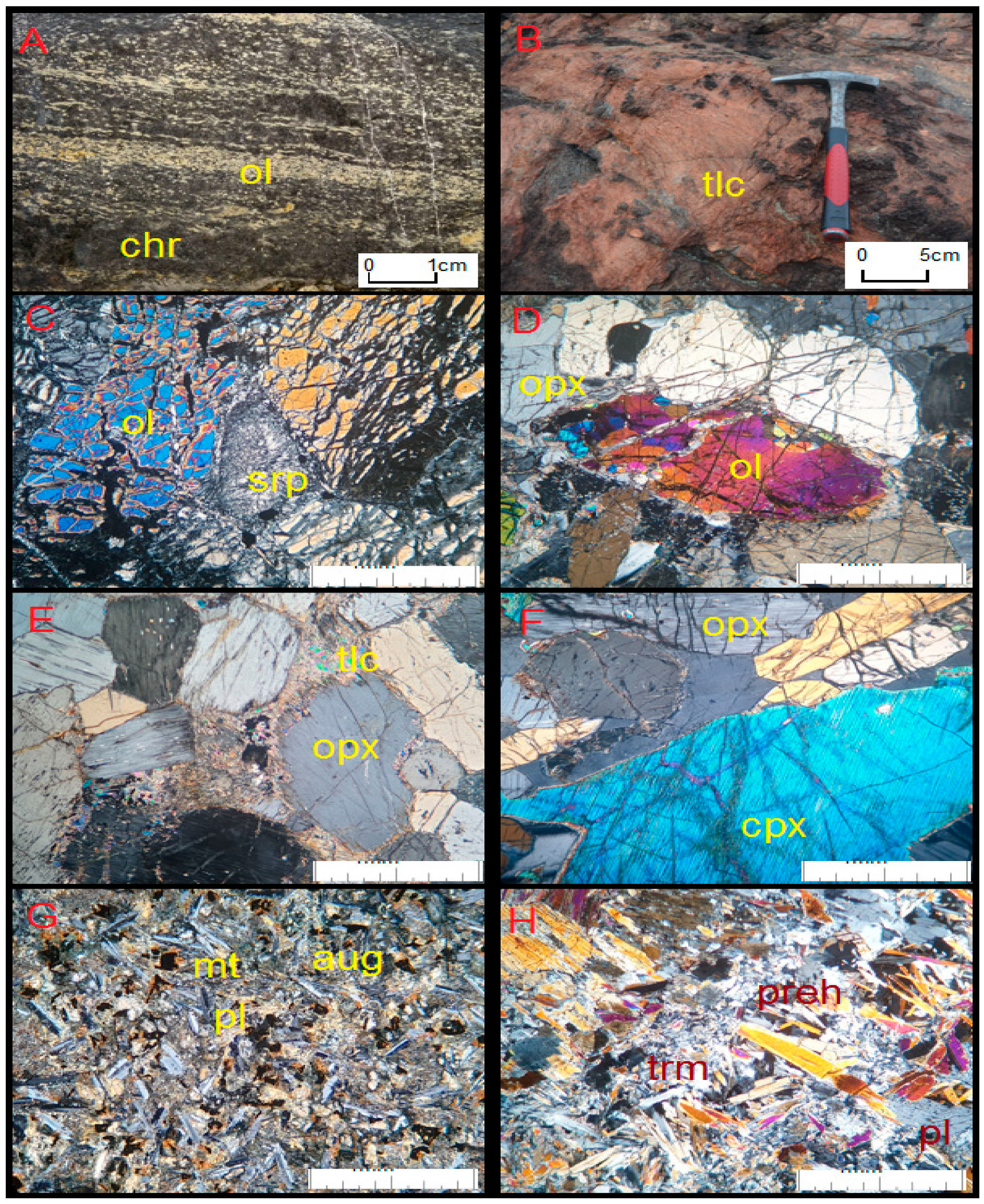
- Dunites are rocks, the background of which is filled with olivine crystals, usually strongly cracked and serpentinized (Figure 4A,C). Next to these crystals, small chromite grains and iron oxides can be identified. In the rock, talc, antigorite and fine grains of sulfides are found. This rock also contains single crystals of orthopyroxene, and sometimes also plagioclases. However, where these minerals are visible, they are separated from the rest of the rock by reactive crowns formed on the olivine-plagioclase border, composed mainly of phlogopite.
- Chromitites are massive rocks made of chromite, which frequently alternate with dunites of various thicknesses, sometimes up to 1 m (Figure 4A). They are usually composed of chromite, which easily winds up on the surface, transforming into hematite pseudomorphoses. In addition to chromite, there are small crystals of olivine, usually cracked and serpentinized. In the rock, there are also single crystals of orthopyroxene filling the spaces of the chromites crystallized on their background.
- Harzburgites are olivine-orthopyroxene rocks. Olyvines in these rocks form large crystals, sometimes with a visible sector texture, against the background of orthopyroxenes (bronzite, Figure 4D). In these rocks, accessory chromite is sometimes visible, usually with a zonal texture (the inner part is enriched with chrome, and the outer part—iron). In the zones of sulfide mineralization, the serpentinization of these rocks is usually evident, sometimes even with the appearance of small amounts of plagioclase. There are reaction crowns, phlogopite, tremolite, and vermiculite, while talc carbonates are visible.
- Norites and olivine norites are rocks with visible orthopyroxene crystals, between which there are plagioclases, sometimes forming an ophitic texture (Figure 4F). Against the background of these minerals, large olivine crystals are sometimes visible, much larger than orthopyroxenes and serpentinized to a different extent. Among these crystals, there is accessory chromite, magnetite, talc, antigorite, and, occasionally, sulfides.
- Gabbronorites are rocks, which, apart from orthopyroxene, contain clinopyroxene that usually forms large crystals with occasional orthopyroxene fouling. Between these crystals are plagioclases (sometimes also corroded), jagged chromite and sulfides.
- Gabbro is a rock that is mainly made of clinopyroxene, which gives them a greenish color. Sometimes the clinopyroxene in these rocks becomes quite large, creating a porphyry texture (especially in the Hippik region in the Monchetundra massif). In addition to these minerals, there are usually clinozoisite, epidote, tremolite, and also plagioclase—which occasionally also come in large sizes and are usually sericitized to different degrees.
- Metaanortosites are rocks heavily altered by younger intrusions in the neighborhood. They are made of hornblende, next to which there is relict clinopyroxene interwoven with tremolite. Besides these minerals, there are plagioclases, and in their vicinity there is titanite, usually with relict ilmenite inside.
- Dolerites are formed by various types of veins with a thickness of up to 1 m, usually, they have an ophitic texture emphasized by plagioclases, between which there is augite, sometimes also tremolite and biotite, and numerous minerals of ilmenite and magnetite (Figure 4G).
- Prehnite-carbonate mineral veins are bright rocks that are up to a few cms thick and are usually emphasized by the amphibole enrichment of the surrounding rocks in the contact zone. They are made of prehnite, sometimes creating nice palisade-shaped crystals, between which there is hematite, albite, and carbonate (Figure 4H).
- Breccias and mylonites are formed in fault zones and are usually made of crushed rocks in their vicinity. In Monchepluton, one can find breccias and mylonites in which crushed crystals of olivine and orthopyroxene can be seen, often along with tremolite and talc, with sulfides usually acting as cement.
- Massive sulfides. Sulfides in the massif in question form a dispersed (described above) nest form, creating an accumulation of minerals among silicate rocks and a massive form in the form of veins, sometimes co-occurring with magnetite. They are made up of large, twin pentlandite crystals, next to which there is pyrrhotite, and sometimes troilite. Chalcopyrite is also found in contact or micro tectonic zones. Bornite, digenite, and galena, sphalerite, zincite and pyrite are secondary in these minerals. Bornite and digenite are usually formed at the border of chalcopyrite and magnetite. In the vicinity of these minerals, they are enriched with tellurides and bismuths of platinum and palladium [37,39].
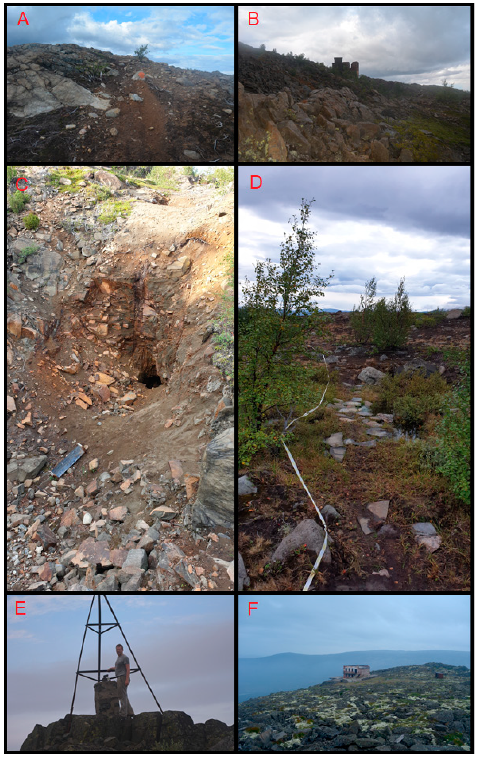
2.3. Historical Heritage
2.4. Climatic and Ecological Characteristics
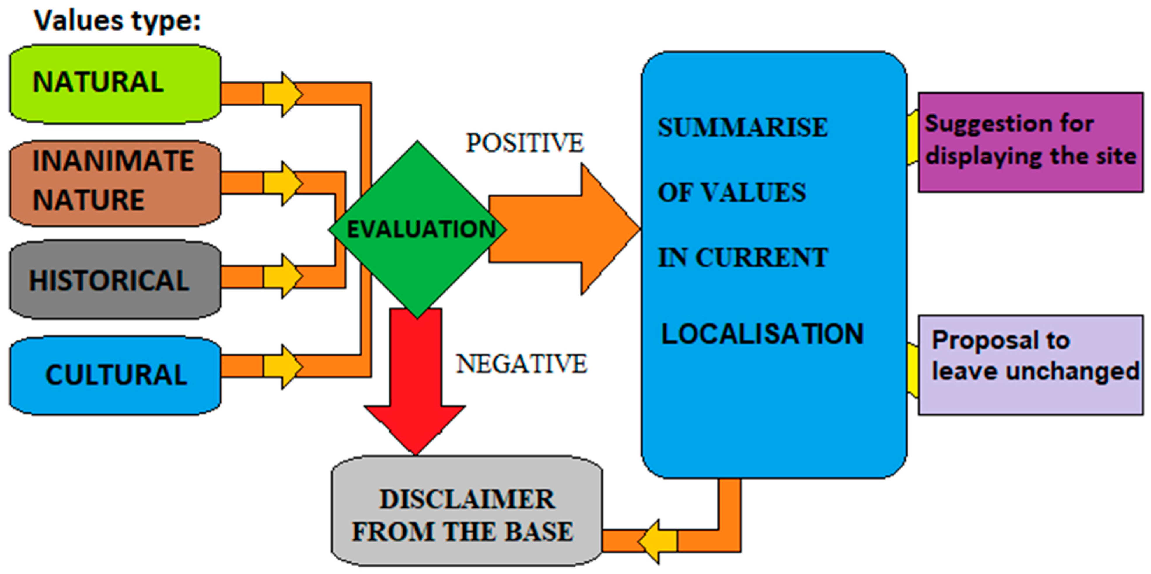
3. Materials and Methods
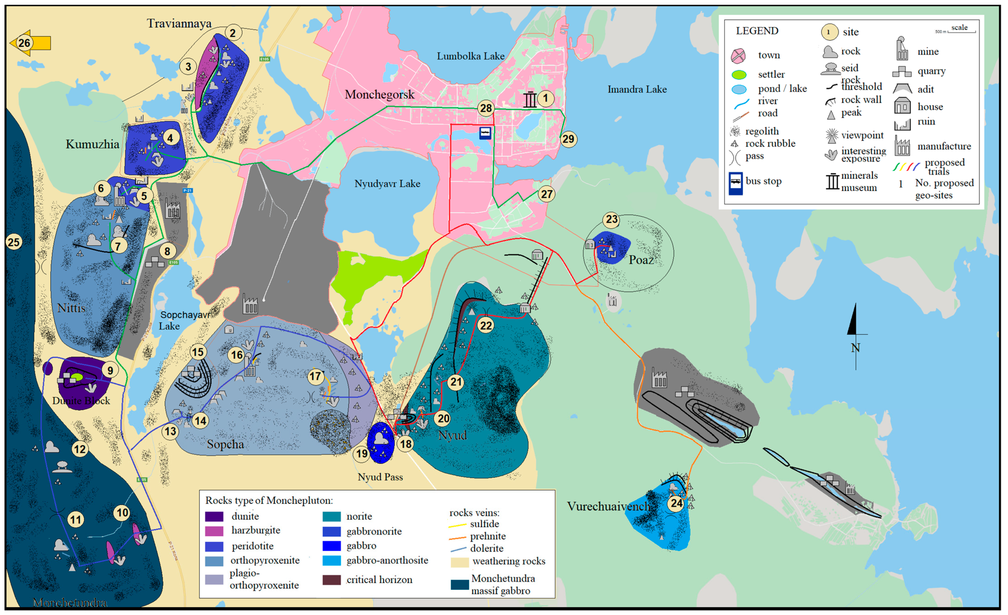
4. Results
Route Proposal
5. Discussion
Proposal for Development of Tourist Infrastructure
6. Conclusions
Author Contributions
Funding
Institutional Review Board Statement
Informed Consent Statement
Data Availability Statement
Acknowledgments
Conflicts of Interest
References
- Dolgiy, A.P. Kola Encyclopedia; Kiselev, A.A., Ed.; Nauka: Sankt Petersburg, Russia, 2008; p. 575. (In Russian) [Google Scholar]
- Murmansk Visitor Center. Available online: https://visitmurmansk.info/en/ (accessed on 1 July 2021).
- Tourist Potential of Murmansk Region. Available online: www.gov-murman.ru (accessed on 1 July 2021).
- Lapland Nature Reserve. Available online: http://www.laplandzap.ru/ (accessed on 1 July 2021).
- Aleksandrova, A.; Aigina, E. Ethno-Tourism Research in Lovozero, Murmansk Region, Russia. SHS Web Conf. 2014, 12, 1036. [Google Scholar] [CrossRef] [Green Version]
- Historical Portal of Murmansk Region. Available online: http://region.murman.ru/history/kola_land/ (accessed on 1 July 2021).
- Voytekhovsky, Y.L. Geological Outdoor Map 1:50000 with a Guidebook; Kolarctic, Rovaniemi Finland Publishing House: Rovaniemi, Finland, 2014; p. 125. [Google Scholar]
- Johansson, P.; Lauri, L.S.; Voytekhovsky, Y.L. Barents Tour for Geotourists; Kolarctic, Rovaniemi Finland Publishing House: Rovaniemi, Finland, 2014; p. 155. [Google Scholar]
- Reynard, E.; Brilha, J. (Eds.) Geoheritage: A Multidisciplinary and Applied Research Topic. In Geoheritage: Assessment, Protection, and Management; Elsevier: Amsterdam, The Netherlands, 2018; pp. 433–438. [Google Scholar]
- UNESCO Global Geoparks. Available online: https://en.unesco.org/global-geoparks/list (accessed on 1 July 2021).
- Alexandrowicz, Z.; Kozłowski, S. From Selected Geosites to Geodiversity Conservation—Polish Example of Modern Framework. In Towards the Balanced Management and Conservation of the Geological Heritage in the New Millennium; Berettino, D., Vallej, M., Gallego, E., Eds.; Soc. Geol. Espaa: Madrid, Spain, 1999; pp. 40–44. [Google Scholar] [CrossRef]
- Brihla, J. Geoheritage: Inventories and evaluation. In Geoheritage: Assessment, Protection, and Management; Reynard, E., Brilha, J., Eds.; Elsevier: Amsterdam, The Netherlands, 2018; pp. 69–86. [Google Scholar]
- Black, G.P.; Gonggrijp, G.P. Fundamental thoughts on Earth-science conservation. Jb. Geol. B 1990, 4, 655–657. [Google Scholar]
- Elízaga, E.; Gallego, E.; García-Cortés, A. Inventaire nacional des sites d’intérêt geologique en Espagne: Méthodologie et déroulement. Mém. Soc. Geol. Fr. 1994, 165, 103–109. [Google Scholar]
- Gray, M. Geodiversity: Developing the paradigma. Proc. Geol. Assoc. 2008, 119, 287–298. [Google Scholar] [CrossRef]
- Gray, M. Geodiversity. Valuing and Conserving Abiotic Nature; Wiley Blackwell: Chichester, UK, 2013. [Google Scholar]
- Zgłobicki, W.; Baran-Zgłobicka, B. Geomorphological Heritage as a Tourist Attraction. A Case Study in Lubelskie Province, SE Poland. Geoheritage 2013, 5, 137–149. [Google Scholar] [CrossRef] [Green Version]
- Gray, M. Geodiversity and Geoconservation: What, Why, and How? George Wright Forum 2005, 22, 4–12. [Google Scholar]
- Brocx, M.; Semeniuk, V. Geoheritage and geoconservation—History, definition, scope, and scale. J. R. Soc. West. Aust. 2007, 90, 53–87. [Google Scholar]
- Henriques, M.H.; Dos Reis, R.P.; Brilha, J.B.; Mota, T. Geoconservation as an Emerging Geoscience. Geoheritage 2011, 3, 117–128. [Google Scholar] [CrossRef] [Green Version]
- Burek, C.V.; Prosser, C.D. The history of geoconservation: An introduction. Geol. Soc. Lond. Spec. Publ. 2008, 300, 1–5. [Google Scholar] [CrossRef] [Green Version]
- Bratton, A.; Smith, B.; McKinley, J.; Lilley, K. Expanding the Geoconservation Toolbox: Integrated Hazard Management at Dynamic Geoheritage Sites. Geoheritage 2013, 5, 173–183. [Google Scholar] [CrossRef]
- Tomić, N.; Božić, S. A modified Geosite Assessment Model (M-GAM) and Its Application on the Lazar Canyon Area (Serbia). J. Environ. Res. 2014, 8, 1041–1052. [Google Scholar]
- Antić, A.; Tomić, N.; Marković, S. Karst geoheritage and geotourism potential in the Pek River lower basin (eastern Serbia). Geogr. Pannon. 2019, 23, 32–46. [Google Scholar] [CrossRef]
- Crofts, R.; Gordon, J.E.; Santucci, V.L. Geoconservation in Protected Areas. In Protected Area Governance and Management; Worboys, G.L., Lockwood, M., Kothari, A., Feary, S., Pulsford, I., Eds.; ANU Press: Gland, Switzerland, 2015; pp. 533–568. [Google Scholar]
- Huber, M.; Zhigunova, G.V.; Bayanova, T.B.; Iakovleva, O.A. Geopark on the Kola Peninsula, perspectives of creation and development. In Proceedings of the International Conference Development of the Arctic Territory, Problems, Perspectives, Murmansk, Russia, 12–15 December 2017. [Google Scholar]
- Huber, M.; Iakovleva, O.; Zhigunova, G.; Menshakova, M.; Gainanova, R. Can the Arctic be saved for the next generations? Study of examples and internships in Murmansk District. IOP Conf. Ser. Earth Environ. Sci. 2021, 678, 012031. [Google Scholar] [CrossRef]
- Stone Hammer Geopark, Canada. Available online: https://www.nbm-mnb.ca/stonehammer-unesco-global-geopark/ (accessed on 1 July 2021).
- Magma Geopark in Norway. Available online: https://magmageopark.no/en/ (accessed on 1 July 2021).
- Huangshan Geopark in China. Available online: http://www.globalgeopark.org/aboutggn/list/china/6407.htm (accessed on 1 July 2021).
- Kocheeva, N.A.; Iurkova, N.A.; Sukhova, M.G.; Redkin, A.G.; Zhuravleva, A.V. Geospatial potential and environmental changes: Case Study of Complex Nature of the Altai Geopark. J. Water Land Dev. 2021, 49, 273–281. [Google Scholar] [CrossRef]
- Bragina, E.; Radeloff, V.; Baumann, M.; Wendland, K.; Kuemmerle, T.; Pidgeon, A. Effectiveness of protected areas in the Western Caucasus before and after the transition to post-socialism. Biol. Conserv. 2015, 184, 456–464. [Google Scholar] [CrossRef]
- Koizumi, T.; Chakraborty, A. Geoecotourism and environmental conservation education: Insights from Japan. GeoJournal 2015, 81, 737–750. [Google Scholar] [CrossRef]
- Korsakova, O.P. Pleistocene marine deposits in the coastal areas of Kola Peninsula (Russia). Quat. Int. 2009, 206, 3–15. [Google Scholar] [CrossRef]
- Bayanova, T.B. Age of Benchmark Geological Complexes of the Kola Region and Magmatism Processes Action; Nauka: Sankt Petersburg, Russia, 2004; p. 174. (In Russian) [Google Scholar]
- Mitrofanov, F.P.; Smolkin, V.F. Stratified Intrusions of the Monchegorsk Ore Region: Petrology, Mineralization, Isotopes, Deep Structure; Kola Scientific Center, Russian Academy of Sciences: Moscow, Russia, 2004; p. 344. (In Russian) [Google Scholar]
- Huber, M. Evolution of the Kola—Lapland Mobile Belt on the Example of Platinum—Beraning Paleoproterooic Layered Intrusion of Monchepluton; Maria Curie-Skłodowska University: Lublin, Poland, 2020; p. 234. (In Polish) [Google Scholar]
- Pozhilienko, V.I.; Gavrilenko, B.V.; Zhirov, C.V.; Zhabin, S.V. Geology of Mineral Areas of the Murmansk Region; Kola Scientific Center, Russian Academy of Sciences: Moscow, Russia, 2002; p. 360. (In Russian) [Google Scholar]
- Grokhovskaya, T.L.; Ivanchenko, V.N.; Karimova, O.V.; Griboedova, I.G.; Samoshnikova, L.A. Geology, mineralogy, and genesis of PGE mineralization in the South Sopcha massif, Monchegorsk complex, Russia. Geol. Ore Depos. 2012, 54, 347–369. [Google Scholar] [CrossRef]
- Arzamastsev, A.A.; Mitrofanov, F.P. Paleozoic plume-lithospheric processes in northeastern Fennoscandia: Evaluation of the composition of the parental mantle melts and magma generation conditions. Petrology 2009, 17, 300–313. [Google Scholar] [CrossRef]
- Glebovitsky, V.A. Early Precambrian of the Baltic Shield; Nauka: St Petersburg, Russia, 2005; p. 710. [Google Scholar]
- Borisenko, E.S.; Bayanova, T.B.; Nerovich, L.I.; Kunakkuzin, E. The paleoproterozoic Monchetundra mafic massif (Kola Peninsula): New geological and geochronological data. Dokl. Earth Sci. 2015, 465, 1107–1111. [Google Scholar] [CrossRef]
- Bayanova, T.; Korchagin, A.; Mitrofanov, A.; Serov, P.; Ekimova, N.; Nitkina, E.; Kamensky, I.; Elizarov, D.; Huber, M. Long-Lived Mantle Plume and Polyphase Evolution of Palaeoproterozoic PGE Intrusions in the Fennoscandian Shield. Minerals 2019, 9, 59. [Google Scholar] [CrossRef] [Green Version]
- Bozhko, N.A. Intraplate basic-ultrabasic magmatism through time in terms of supercontinental cyclicity. Mosc. Univ. Geol. Bull. 2010, 65, 161–176. [Google Scholar] [CrossRef]
- Bozhko, N.A. Supercontinental cyclicity in the Earth’s evolution. Mosc. Univ. Geol. Bull. 2009, 64, 75–91. [Google Scholar] [CrossRef]
- Ernst, R.; Bleeker, W. Large igneous provinces (LIPs), giant dyke swarms, and mantle plumes: Significance for breakup events within Canada and adjacent regions from 2.5 Ga to the Present. Can. J. Earth Sci. 2010, 47, 695–739. [Google Scholar] [CrossRef]
- Ernst, R.E.; Srivastava, R.K. India’s Place in the Proterozoic World, Constraints from the Large Igneous Provinces (LIP) Record. In Indian Dykes: Geochemistry, Geophysics, and Geochronology; Srivastava, R.K., Sivaji, C., Chalapathi Rao, N.V., Eds.; Narosa Publishing House Pvt. Ltd.: New Delhi, India, 2008; pp. 41–56. [Google Scholar]
- Evans, D.A.D.; Li, Z.X.; Murphy, J.B. Four-Dimensional Context of Earth’s Supercontinent; The Geological Society of London, Special Publications: London, UK, 2016; Volume 424, pp. 1–14. [Google Scholar]
- Lubnina, N.V.; Slabunov, A.I. Reconstruction of the Kenorland supercontinent in the Neoarchean based on paleomagnetic and geological data. Mosc. Univ. Geol. Bull. 2011, 66, 242–249. [Google Scholar] [CrossRef]
- Huber, M.; Halas, S.; Piestrzyński, A. Petrology of Gabbroides and Isotope Signature of Sulfide Mineralization from Fedorov-Pansky Layered Mafic Intrusion, Kola Peninsula, Russia. Geochronometria 2009, 33, 19–22. [Google Scholar] [CrossRef] [Green Version]
- Baluev, A.S.; Zhuravlev, V.; Przhiyalgovskii, E. New data on the structure of the central part of the White Sea paleorift system. Dokl. Earth Sci. 2009, 427, 891–896. [Google Scholar] [CrossRef]
- Britvin, S.N.; Ivanov, G.Y.; Yakuvenchuk, V.N. Mineralogical Accessory on the Kola Peninsula; World of Stones: Apatity, Russia, 1995; p. 56. (In Russian) [Google Scholar]
- Bozhko, N.A. On two types of supercontinental cyclicity. Mosc. Univ. Geol. Bull. 2011, 66, 313–322. [Google Scholar] [CrossRef]
- Grebnev, R.A.; Rundkvist, T.V.; Pripachkin, P.V. Geochemistry of mafic rocks of the PGE-bearing Vurechuaivench Massif (Monchegorsk Complex, Kola region). Geochem. Int. 2014, 52, 726–739. [Google Scholar] [CrossRef]
- Huber, M.A.; Hałas, S.; Neradovsky, Y.N.; Bayanova, T.B.; Mokrushin, A.W.; Lata, L. Stable isotope geochemistry of sulfides from intrusion in Monchegorsk, northern part of Baltic Shield. Geochronometria 2016, 43, 96–101. [Google Scholar] [CrossRef] [Green Version]
- Huber, M.; Hałas, S.; Serov, P.A.; Ekimova, N.A.; Bayanova, T.B. Stable isotope geochemistry, and Sm-Nd, U-Pb dating of sulfides from layered intrusions in the northern part of Baltic Shield. Cent. Eur. Geol. 2013, 56, 134–135. [Google Scholar]
- Lubnina, N.V.; Pasenko, A.M.; Novikova, M.A.; Bubnov, A.Y. The East European craton at the end of the Paleoproterozoic: A new paleomagnetic pole of 1.79–1.75 Ga. Mosc. Univ. Geol. Bull. 2016, 71, 8–17. [Google Scholar] [CrossRef]
- Aune, S.; Hofgaard, A.; Söderström, L. Contrasting climate- and land-use-driven tree encroachment patterns of subarctic tundra in northern Norway and the Kola Peninsula. Can. J. For. Res. 2011, 41, 437–449. [Google Scholar] [CrossRef]
- Møller, J.J.; Yevzerov, V.Y.; Kolka, V.V.; Corner, G.D. Holocene raised-beach ridges and sea-ice-pushed boulders on the Kola Peninsula, northwest Russia: Indicators of climatic change. Holocene 2002, 12, 169–176. [Google Scholar] [CrossRef]
- Konstantinova, N.A. Flora and Vegetation of Murmansk Region; Kola Science Centre, RAS: Apatity, Russia, 1999; p. 175. (In Russian) [Google Scholar]
- Koroleva, N.E. Phytosociological survey of the tundra vegetation of the Kola Peninsula, Russia. J. Veg. Sci. 1994, 5, 803–812. [Google Scholar] [CrossRef]
- Konstantinov, A.S.; Koryakin, O.A.; Makarova, V.V. Red Book of the Murmansk Region, 2nd ed.; Asia-Print: Kemerovo, Russia, 2014; p. 584. (In Russian) [Google Scholar]
- Trutnev, Y.P.; Kamelin, R.V. Red Book of the Russian Federation (Plants and Mushrooms); Partnership of Scientific Publications KMK: Moscow, Russia, 2008; p. 855. (In Russian) [Google Scholar]
- James-Williamson, S.A.; Aratram, M.; Green, P.E. Protecting Geoheritage in the Caribbean—Insights from Jamaica. Geoheritage 2017, 9, 195–209. [Google Scholar] [CrossRef]
- Williams, F. Safeguarding Geoheritage in Ethiopia: Challenges Faced and the Role of Geotourism. Geoheritage 2020, 12, 31. [Google Scholar] [CrossRef]
- Woo, K.S.; Chun, S.S.; Moon, K.O. Outstanding Geoheritage Values of the Island-Type Tidal Flats in Korea. Geoheritage 2020, 12, 8. [Google Scholar] [CrossRef]
- Kubalíková, L. Geomorphosite assessment for geotourism purposes. Czech J. Tour. 2013, 2, 80–104. [Google Scholar] [CrossRef]
- Vujičić, M.D.; Vasiljević, D.J.A.; Marković, S.B.; Hose, T.A.; Lukić, T.; Hadžić, O.; Janićević, S. Preliminary geosite assessment model (GAM) and its application on Fruška Gora Mountain, potential geotourism destination of Serbia. Acta Geogr. Slov. 2011, 51, 361–377. [Google Scholar] [CrossRef]
- Huber, M.; Iakovleva, O.; Zhigunova, G.; Menshakova, M.; Gainanova, R.; Moroniak, M. Geoheritage of the Western Khibiny Ingenious Alkaline Rocks Intrusion (Kola Peninsula, Arctic Russia): Evaluation and Geotourism opportunities. Geoheritage 2021, 13, 72. [Google Scholar] [CrossRef]
- United Nations Educational, Scientific, and Cultural Organization. UNESCO Geoparks Programme—A new initiative to promote a global network of Geoparks safeguarding, and developing selected areas having significant geological features. In Proceedings of the Executive Board Meeting, Hundred, and Fifty-Sixth Session (156 EX/11 Rev.), Paris, France, 15 April 1999; p. 3. [Google Scholar]
- United Nations Educational, Scientific, and Cultural Organization. Global Geoparks Network. Paris Division of Ecological, and Earth Sciences; UNESCO: Paris, France, 2011. [Google Scholar]
- Leibenzon, G. On screen Monchegorsk. Kola Nickel 2010, 6, 398. [Google Scholar]
- Lukuchev, Y.C. City in the Beautiful Tundra. Local History Narrative; Sever: Murmansk, Russia, 1993. [Google Scholar]
- Wimbledon, W.A.P.; Smith-Meyer, S. Geoheritage in Europe and Its Conservation; ProGeo: Oslo, Norway, 2012. [Google Scholar]
- Reynard, E. Scientific research and tourist promotion of geomorphological heritage. Geogr. Fis. Din. Quat. 2008, 31, 225–230. [Google Scholar]
- Reynard, E. The Assessment of Geomorphosites. In Geomorphosites; Reynard, E., Coratza, P., Regolini-Bissig, G., Eds.; Verlag Dr. Friedrich Pfeil: München, Germany, 2009; pp. 63–71. [Google Scholar]
- Reynard, E.; Regolini-Bissig, G.; Kozlik, L.; Benedetti, S. Assessment and promotion of cultural geomorphosites in the Trient Valley (Switzerland). Mem. Descr. Carta Geol. d’Ital. 2009, 87, 181–189. [Google Scholar]
- Farsani, N.T.; Esfahani, M.A.G.; Shokrizadeh, M. Understanding Tourists’ Satisfaction and Motivation Regarding Mining Geotours (Case Study: Isfahan, Iran). Geoheritage 2018, 11, 681–688. [Google Scholar] [CrossRef]
- Gravis, I.; Németh, K.; Twemlow, C.; Németh, B. The Case for Community-Led Geoheritage and Geoconservation Ventures in Māngere, South Auckland, and Central Otago, New Zealand. Geoheritage 2020, 12, 19. [Google Scholar] [CrossRef]
- Hose, T.A. 3G’s for Modern Geotourism. Geoheritage 2012, 4, 7–24. [Google Scholar] [CrossRef]
- Steiger, R.; Jäger, E. Subcommission on geochronology: Convention on the use of decay constants in geo- and cosmochronology. Earth Planet. Sci. Lett. 1977, 36, 359–362. [Google Scholar] [CrossRef]
- Vdovets, M.S.; Silantiev, V.V.; Mozzherin, V.V. A National Geopark in the Republic of Tatarstan (Russia): A Feasibility Study. Geoheritage 2010, 2, 25–37. [Google Scholar] [CrossRef]
- Zangmo, T.G.; Kagou, A.D.; Nkouathio, D.G.; Gountié, M.D.; Kamgang, P. The Volcanic Geoheritage of the Mount Bamenda Calderas (Cameroon Line): Assessment for Geotouristic and Geoeducational Purposes. Geoheritage 2017, 9, 255–278. [Google Scholar] [CrossRef]
- Errami, E.; Brocx, M.; Semeniuk, V. From Geoheritage to Geoparks. Case Studies from Africa and beyond; Springer International Publishing: Cham, Switzerland, 2015; p. 269. [Google Scholar] [CrossRef]
- Erikstad, L. Geoheritage and geodiversity management—The questions for tomorrow. Proc. Geol. Assoc. 2013, 124, 713–719. [Google Scholar] [CrossRef]
- Gürer, A.; Gürer, Ö.F.; Sangu, E. Compound geotourism and mine tourism potentiality of Soma region, Turkey. Arab. J. Geosci. 2019, 12, 734. [Google Scholar] [CrossRef]
- Cayla, N. An Overview of New Technologies Applied to the Management of Geoheritage. Geoheritage 2014, 6, 91–102. [Google Scholar] [CrossRef]
- Prosser, C.D. Geoconservation, Quarrying and Mining: Opportunities and Challenges Illustrated through Working in Partnership with the Mineral Extraction Industry in England. Geoheritage 2018, 10, 259–270. [Google Scholar] [CrossRef]
- Dos Santos, W.F.S.; Carvalho, I.; Brilha, J. Public Understanding on Geoconservation Strategies at the Passagem das Pedras Geosite, Paraíba (Brazil): Contribution to the Rio do Peixe Geopark Proposal. Geoheritage 2019, 11, 2065–2077. [Google Scholar] [CrossRef]
- Burek, C. The Role of LGAPs (Local Geodiversity Action Plans) and Welsh RIGS as Local Drivers for Geoconservation within Geotourism in Wales. Geoheritage 2012, 4, 45–63. [Google Scholar] [CrossRef]


| Site Name | Values Type | Total | ||||
|---|---|---|---|---|---|---|
| Geology | Natural | Historical | Inanimate Nature | |||
| 1 | Monchegorsk museum | 1.0 | 1.0 | 1.0 | 0.0 | 3.0 |
| 2 | East Traviannaya | 1.5 | 1.0 | 0.0 | 1.0 | 3.5 |
| 3 | Traviannaya mine | 1.5 | 0.0 | 1.0 | 0.5 | 3.0 |
| 4 | Kumuzhia | 1.5 | 1.0 | 0.0 | 0.5 | 3.0 |
| 5 | N Nittis slopes | 1.0 | 1.0 | 0.0 | 0.5 | 2.5 |
| 6 | Nittis mine | 1.5 | 0.0 | 1.0 | 0.0 | 2.5 |
| 7 | Nittis peak | 1.0 | 1.0 | 0.0 | 1.0 | 3.0 |
| 8 | E Nittis gravel pit | 0.5 | 0.0 | 0.0 | 0.0 | 0.5 |
| 9 | Dunite block quarry | 1.5 | 0.0 | 0.5 | 0.5 | 2.5 |
| 10 | Monchetundra quarry | 1.5 | 0.0 | 0.5 | 0.0 | 2.0 |
| 11 | Monchetundra peak | 1.0 | 1.0 | 0.5 | 1.5 | 4.0 |
| 12 | Monchetundra “seids” | 1.0 | 1.0 | 1.5 | 1.5 | 5.0 |
| 13 | Sopcha mine | 0.5 | 0.0 | 1.0 | 0.0 | 1.5 |
| 14 | W Sopcha peak | 1.0 | 1.0 | 0.0 | 1.0 | 3.0 |
| 15 | N Sopcha quarry | 1.0 | 0.0 | 0.5 | 0.0 | 1.5 |
| 16 | N Sopcha mine | 1.5 | 0.0 | 1.0 | 0.0 | 2.5 |
| 17 | E Sopcha | 1.5 | 0.0 | 0.0 | 1.0 | 2.5 |
| 18 | Nyud quarry | 1.5 | 0.0 | 0.5 | 0.0 | 2.0 |
| 19 | Nyud pass | 1.0 | 1.0 | 0.0 | 0.5 | 2.5 |
| 20 | Nyud shaft | 1.0 | 0.0 | 1.0 | 0.0 | 2.0 |
| 21 | Nyud “terrace” | 1.5 | 0.0 | 0.0 | 1.0 | 2.5 |
| 22 | Nyud peak | 1.0 | 1.0 | 0.0 | 1.0 | 3.0 |
| 23 | Poaz | 1.0 | 1.0 | 0.0 | 1.0 | 3.0 |
| 24 | Vurechuaivench | 0.5 | 1.0 | 0.0 | 1.0 | 2.5 |
| 25 | Hippik peak | 1.0 | 1.5 | 0.0 | 1.5 | 4.0 |
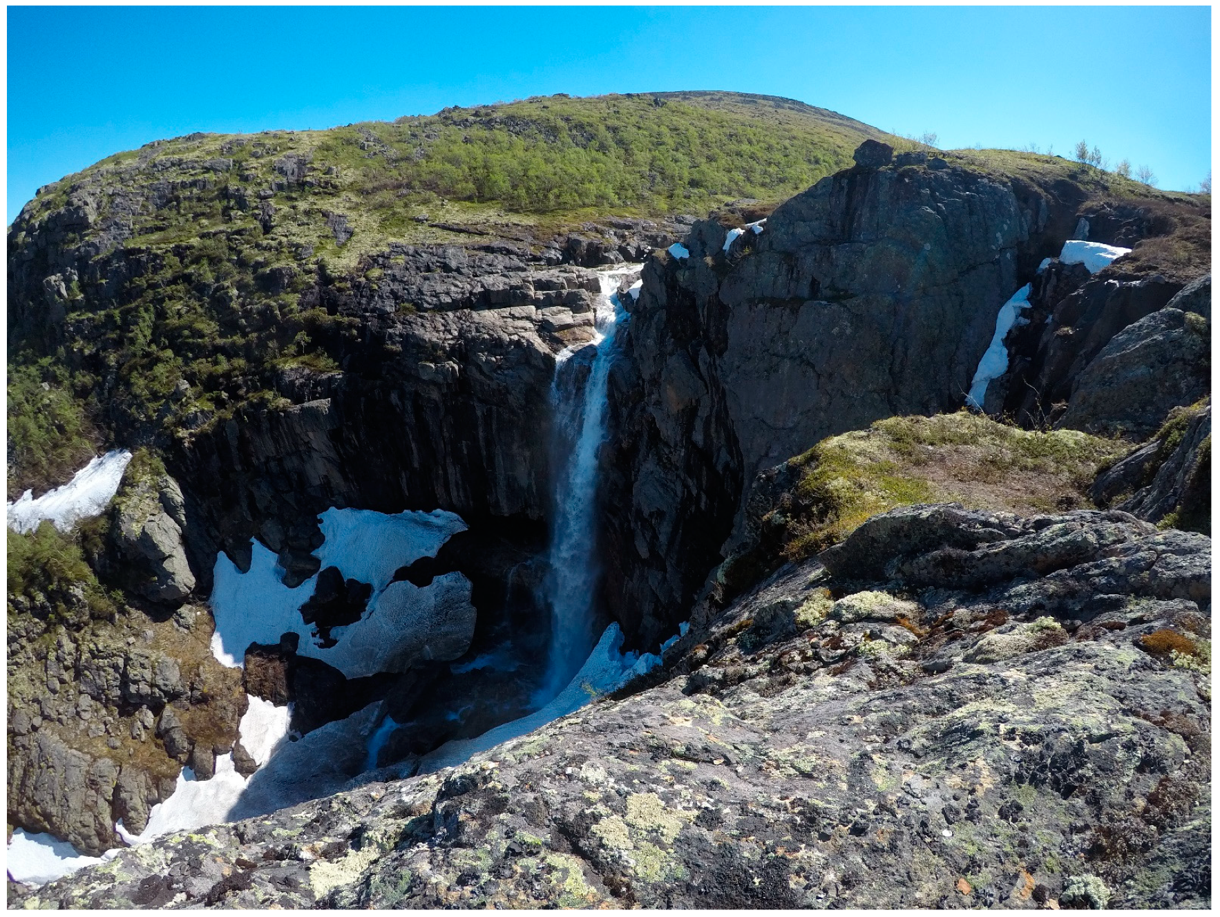
| 26 | Vaikis waterfall | 1.0 | 1.5 | 0.0 | 1.5 | 4.0 |
| 27 | Monchegorsk monastery | 0.0 | 0.5 | 0.5 | 0.0 | 1.0 |
| 28 | Monchegorsk center | 0.0 | 0.0 | 0.5 | 0.0 | 0.5 |
| 29 | Imandra Lake | 0.5 | 0.5 | 0.5 | 0.0 | 1.5 |
| Site Name | Longitude | Latitude | |
|---|---|---|---|
| 1 | Monchegorsk museum | 67°56′20.2″ N | 32°56′57.1″ E |
| 2 | East Traviannaya | 67°56′43.7″ N | 32°49′01.2″ E |
| 3 | Traviannaya mine | 67°56′32.9″ N | 32°48′11.5″ E |
| 4 | Kumuzhia | 67°55′56.3″ N | 32°47′31.2″ E |
| 5 | N Nittis slopes | 67°55′08.6″ N | 32°46′35.5″ E |
| 6 | Nittis mine | 67°55′10.3″ N | 32°46′18.2″ E |
| 7 | Nittis peak | 67°54′50.1″ N | 32°45′21.1″ E |
| 8 | E Nittis gravel pit | 67°54′11.3″ N | 32°47′03.8″ E |
| 9 | Dunite block quarry | 67°53′50.2″ N | 32°45′28.5″ E |
| 10 | Monchetundra quarry | 67°51′59.6″ N | 32°45′15.8″ E |
| 11 | Monchetundra peak | 67°52′11.9″ N | 32°44′40.2″ E |
| 12 | Monchetundra seids | 67°52′23.3″ N | 32°44′33.2″ E |
| 13 | Sopcha mine | 67°53′11.0″ N | 32°48′03.5″ E |
| 14 | W Sopcha peak | 67°53′12.9″ N | 32°48′26.6″ E |
| 15 | N Sopcha quarry | 67°53′32.6″ N | 32°48′30.1″ E |
| 16 | N Sopcha mine | 67°53′17.6″ N | 32°50′05.3″ E |
| 17 | E Sopcha | 67°53′35.7″ N | 32°51′42.9″ E |
| 18 | Nyud quarry | 67°53′11.3″ N | 32°53′58.6″ E |
| 19 | Nyud pass | 67°52′58.6″ N | 32°53′17.5″ E |
| 20 | Nyud shaft | 67°53′15.2″ N | 32°54′40.2″ E |
| 21 | Nyud “terrace” | 67°53′34.3″ N | 32°55′01.5″ E |
| 22 | Nyud peak | 67°53′53.6″ N | 32°55′36.9″ E |
| 23 | Poaz | 67°55′01.5″ N | 32°58′35.6″ E |
| 24 | Vurechuaivench | 67°52′33.6″ N | 33°00′53.3″ E |
| 25 | Hippik peak | 67°56′53.1″ N | 32°38′58.4″ E |
| 26 | Vaikis waterfall | 68°01′35.9″ N | 32°26′45.0″ E |
| 27 | Monchegorsk monastery | 67°55′34.5″ N | 32°57′42.1″ E |
| 28 | Monchegorsk center | 67°56′09.0″ N | 32°55′55.6″ E |
| 29 | Imandra Lake | 67°56′11.2″ N | 32°57′56.8″ E |
| Site | Distance | Average Time | Site | Distance | Average Time [minutes] | ||
|---|---|---|---|---|---|---|---|
| [km] | On Foot | By Car | [km] | On Foot | By Car | ||
| 28–1 | 0.5 | 7 | 1 | 15–16 | 0.6 | 20 | ** |
| 1–2 | 6.5 | 92 | 9 * | 16–17 | 2 | 60 | ** |
| 2–3 | 0.5 | 30 | ** | 13–17 | 3 | 60 | ** |
| 3–4 | 2 | 60 | 1 * | 17–19 | 1 | 60 | ** |
| 4–5 | 1.5 | 40 | 1 * | 19–1 | 7 | 95 | 7 |
| 5–6 | 1 | 60 | ** | 19–18 | 0.6 | 10 | 2 |
| 6–7 | 1 | 90 | ** | 19–20 | 0.7 | 20 | ** |
| 7–8 | 1.5 | 90 | ** | 20–21 | 0.9 | 25 | ** |
| 8–9 | 1 | 20 | 1 * | 21–22 | 0.8 | 30 | ** |
| 9–1 | 12 | 200 | 12 * | 22–23 | 2.5 | 50 | ** |
| 9–10 | 3 | 50 | 2 * | 23–1 | 4.5 | 60 | 8 |
| 10–11 | 3 | 60 | ** | 23–24 | 6 | 94 | 4 * |
| 11–12 | 0.5 | 20 | ** | 24–1 | 8.5 | 127 | 11 * |
| 12–9 | 3 | 45 | ** | 12–25 | 12 | 180 | ** |
| 1–10 | 13.5 | 205 | 13 | 25–26 | 15 | 255 | ** |
| 1–13 | 12.5 | 180 | 12 * | 26–1 | 30 | 500 | 14 * |
| 12–13 | 1.5 | 20 | 1 | 28–27 | 2.7 | 33 | 7 |
| 13–14 | 0.5 | 40 | ** | 28–29 | 1.3 | 17 | 3 |
| 14–15 | 0.6 | 30 | ** | ||||
Publisher’s Note: MDPI stays neutral with regard to jurisdictional claims in published maps and institutional affiliations. |
© 2021 by the authors. Licensee MDPI, Basel, Switzerland. This article is an open access article distributed under the terms and conditions of the Creative Commons Attribution (CC BY) license (https://creativecommons.org/licenses/by/4.0/).
Share and Cite
Huber, M.; Zhigunova, G.; Menshakova, M.; Iakovleva, O.; Karimova, M. Geoheritage of the Monchegorsk Igneous Layered Paleoproterozoic Intrusion (Kola Peninsula, Arctic Russia): Evaluation and Geotourism Opportunities. Heritage 2021, 4, 3583-3610. https://0-doi-org.brum.beds.ac.uk/10.3390/heritage4040198
Huber M, Zhigunova G, Menshakova M, Iakovleva O, Karimova M. Geoheritage of the Monchegorsk Igneous Layered Paleoproterozoic Intrusion (Kola Peninsula, Arctic Russia): Evaluation and Geotourism Opportunities. Heritage. 2021; 4(4):3583-3610. https://0-doi-org.brum.beds.ac.uk/10.3390/heritage4040198
Chicago/Turabian StyleHuber, Miłosz, Galina Zhigunova, Maria Menshakova, Olga Iakovleva, and Maria Karimova. 2021. "Geoheritage of the Monchegorsk Igneous Layered Paleoproterozoic Intrusion (Kola Peninsula, Arctic Russia): Evaluation and Geotourism Opportunities" Heritage 4, no. 4: 3583-3610. https://0-doi-org.brum.beds.ac.uk/10.3390/heritage4040198