
Geospatial Information Categories Mapping in a Cross-lingual Environment: A Case Study of “Surface Water” Categories in Chinese and American Topographic Maps


Abstract
:1. Introduction
2. Related Works
2.1. Semantic Interpretation
2.2. Ontology Mapping
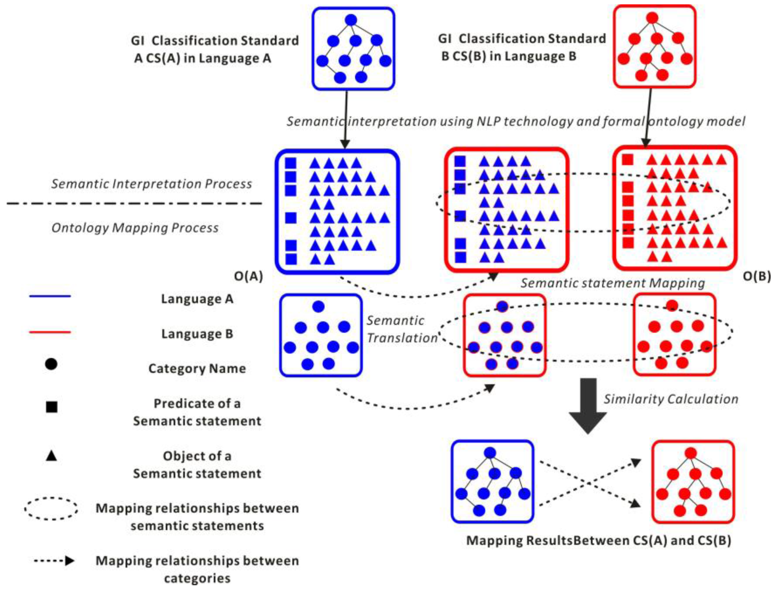
3. Methodologies
3.1. Semantic Interpretation
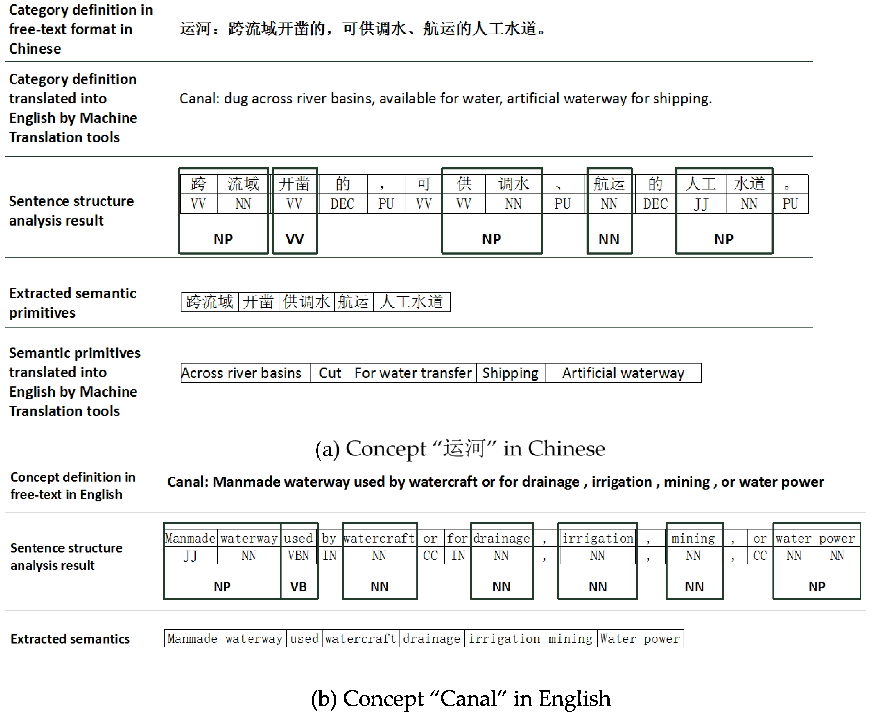
3.1.1. Semantic Primitive Extraction
- One category definition in free-text format is chosen as the input natural language material;
- Word segmentation is performed to split the whole sentence into individual words;
- The nominal phrases and verb phrases are chunked, and the sentence structure is analyzed to extract lexical patterns as the semantic primitives.
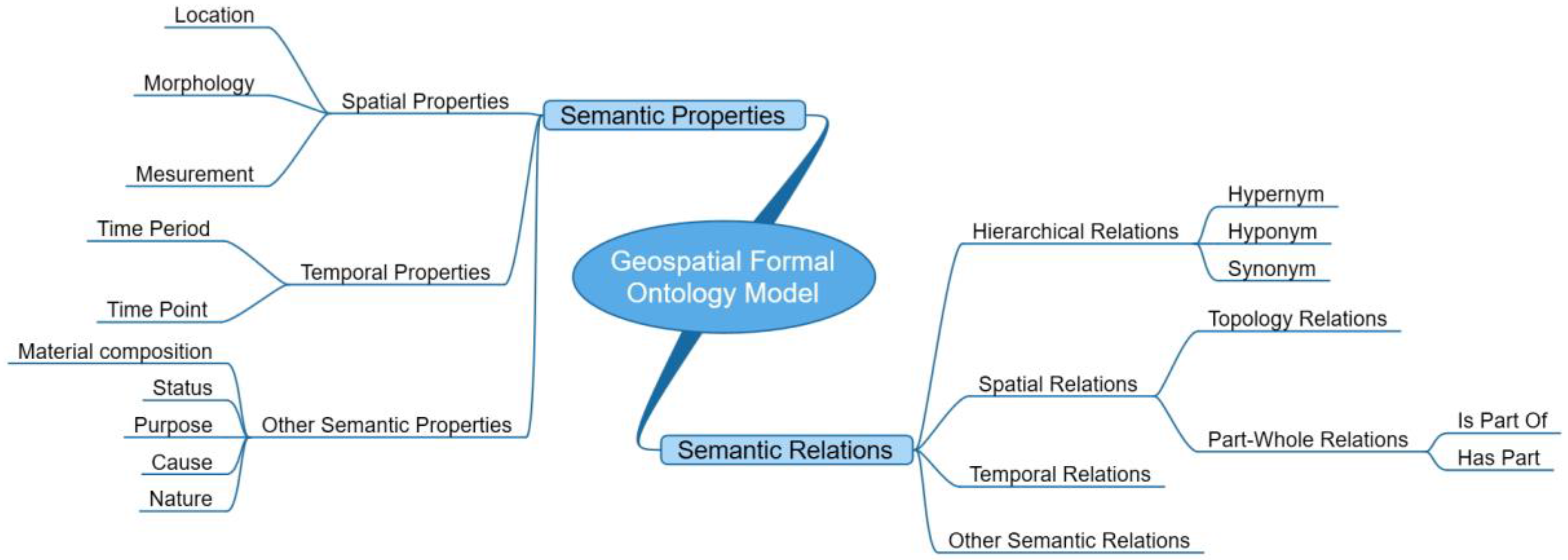
3.1.2. Construction of the Formal Ontology Model
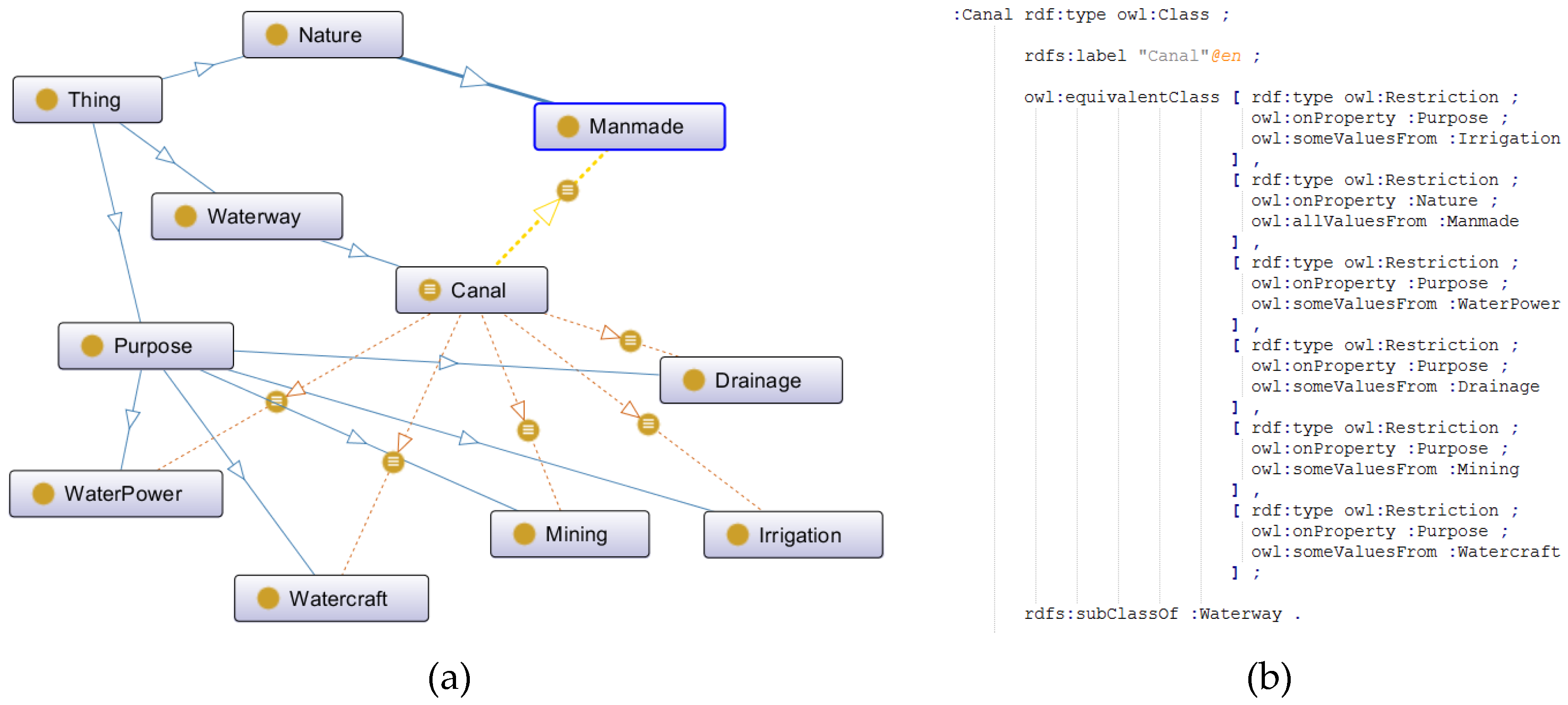
3.1.3. Transformation from Semantic Primitives to Formal Ontology Model
- (1)
- The GI category can be represented by a number of semantic relations/properties; however, the number of semantic relations/properties involved should be minimized to avoid redundancy.
- (2)
- Not every GI category must cover all semantic relations/properties in the model. The situation whereby two different categories use the same set of semantic relations/properties to represent their semantics cannot be guaranteed.
- (3)
- The semantic information of a certain category in our model is the combination of different semantic relations-properties and their values. This combination should represent all the semantic information of the category and be able to distinguish the different geospatial categories within and beyond domain ontologies to avoid ambiguity.
- (4)
- The hypernym, hyponym, and synonym relations should be included in the hierarchical relation group. If category A is a hyponym of category B, A must inherent all the semantic properties/relations of B to retain semantic consistency.
3.2. Ontology Mapping Algorithms
3.2.1. Semantics Translation
| Algorithm 1. Semantics Translation. |
| 1: Input: Formal ontologies OA(S(CNA), S(SSA)) in LA |
| 2: Output: Translation candidate result set of the semantics in OA, O’A (S(TC(CNA)), S(TC(SSA-object))) in |
| 3: LB. |
| 4: Symbols: |
| 5: S(TC(CNA))—Translation candidate result set of S(CNA) in LB. |
| 6: S(TC(SSA))—Translation candidate result set of S(SSA) in LB. |
| 7: ssA-object—The Object part of the semantic statement ssA. |
| 8: 1:for each category name cnA in S(CNA), translate cnA in LA into cnA’ in LB by using different Machine Translation (MT) web services (Google Translator API at” http://translate.google.cn/”, Bing Translator API at” http://www.bing.com/translator/?ref=SALL&mkt=zh-CN”, and Baidu Translator API at ”http://fanyi.baidu.com/?aldtype=16047#zh/en/”), collect all of the translation results about cnA, into the translation candidate results TC(cnA), and store all of the category name translation candidate results into the translation candidate set S(TC(CNA)); |
| 9: 2:for each semantic statement ssA in S(SSA), according to the OWL triple statement syntax, it can be subdivided into three part, Subject, Predicate, and Object, translate ssA-object in LA into ssA’-object in LB by using different Machine Translation (MT) web services, collect all of the translation results about ssA-object, into the translation candidate results TC(ssA-object), and store all of the semantic statements translation candidate results into the translation candidate set S(TC(SSA-object)). |
| 10: Take the “运河” category in Chinese as an example, the semantic primitives of the “运河” category are extracted by applying NLP tools to the set of phrases including “跨流域”, “开凿”, “供调水”, ”航运”, ”人工水道”. Then, transforming these semantic primitives into the proposed formal ontology model, the semantics of the category “运河”can be represented as a set of several semantic statements as follows: |
| 11:
|
| 12: And the semantics translation result of C运河 in English is as follows: |
| 13:
|
3.2.2. Semantic Statement Mapping
| Algorithm 2. Semantic Statement Mapping. |
| 1: Input: O’A (S(TC(CNA)), S(TC(SSA-object))) in LB, Formal ontologies OB(S(CNB), S(SSB)) in LB |
| 2: Output: Mapping result set M(OA, OB) about category names and semantic statements between 3: OA and OB. |
| 4: Symbols: |
| 5: T(ss)—semantic property/relation types for a certain semantic statement ss. |
| 6: M(OA’, OB)—mapping relationships about category names and semantic statements between OA’ |
| 7: and OB. |
| 8: 1: for each category name cnA in S(CNA), find the translation candidate results of cnA, TC(cnA), |
| 9: 2: for each translation candidate tc(cnA) in TC(cnA), search S(CNB) in OB, find the matched |
| 10: category name cnB in S(CNB) by applying Equation(10), |
| 11: 3: If there is a translation candidate tc(cnA) has the mapping relationship “exact match” |
| 12: with cnB, store the mapping result m(cnA, cnB, ‘exact match’) in M(OA, OB); |
| 13: 4: else If there is a translation candidate tc(cnA) has the mapping relationship |
| 14: “close match” with cnB, store the mapping result m(cnA, cnB, ‘close match’) in M(OA, OB); |
| 15: 5: for each semantic statement ssA in S(SSA), find the translation candidate results of ssA-object, |
| 16: TC(ssA-object), |
| 17: 6: for each translation candidate tc(ssA-object) in TC(ssA-object), search S(SSB-object) in OB, |
| 18: find the matched semantic statement Object, ssB-object in S(SSB) by applying Equation(10), |
| 19: 7: If there is a translation candidate tc(ssA-object) has the mapping relationship “exact |
| 20: match” with ssB-object, and T(ssA) equals T(ssB), store the mapping result m(ssA, ssB, ‘exact |
| 21: match’) in M(OA, OB); |
| 22: 8: else If there is a translation candidate tc(ssA-object) has the mapping relationship “close |
| 23: match” with ssB-object, and T(ssA) equals T(ssB), store the mapping result m(ssA, ssB, ‘close |
| 24: match’) in M(OA, OB). |
| 25:
|
3.2.3. Similarity Calculation
| Algorithm 3. Similarity Calculation. |
| 1: Input: Categories Ca(CNa, SSa) in OA, Cb(CNb, SSb) in OB and mapping relationship set M(OA, OB) |
| 2: about category names and semantic statements between OA and OB. |
| 3: Output: Semantic similarity value between Ca and Cb, Sim(a, b). |
| 4: Symbols: |
| 5: Cot(SSa)—the number of semantic statements in SSa. |
| 6: Cot(SSb)—the number of semantic statements in SSb. |
| 7: m(CNa, CNb)—mapping relationship between CNa and CNb. |
| 8: m(SSa(i), SSb(j))—mapping relationship between SSa(i) in Ca and SSb(j) in Cb. |
| 9: Pt(SSab)—the sum of the match point value between SSa and SSb. |
| 10: Pt(CNab)—the match point value between CNa and CNb. |
| 11: 1: for each semantic statement SSa(i) in SSa, find the matched semantic statement SSb(j) in SSb |
| 12: based on the mapping relationship set M(OA, OB); |
| 13: If m(SSa(i), SSb(j)) = “exact match”, then the match point value between SSa(i) and SSb(j) is assigned 1; |
| 14: Else if m(SSa(i), SSb(j)) = “close match”, then the match point value between SSa(i) and SSb(j) is |
| 15: assigned 0.5; |
| 16: 2: Record the sum of the match point values between SSa and SSb as Pt(SSab) and the number of |
| 17: matched statements between SSa and SSb as Cot(SSab); |
| 18: 3: find the mapping relationship between CNa and CNb based on M(OA, OB), |
| 19: If m(CNa, CNb) = “exact match”, then the match point value between CNa and CNb is assigned 1; |
| 20: Else if m(CNa, CNb) = “close match”, then the match point value between CNa and CNb is |
| 21: assigned 0.5; |
| 22: 4: Record the match point value between CNa and CNb as Pt(CNab); |
| 23: 5: the similarity of categories Ca and Cb can be calculated using the following equation: |
| 24:
|
| 25: In addition, the mapping relationships between category pairs Ca and Cb, namely, MR(a, b), can |
| 26: be determined using the following equation: |
| 27:
|
4. A Case Study
4.1. Study Material
- (1)
- Both standards have their own classification system to address the categories of “surface water”. The categories in CSC are organized using a four-level hierarchy with six major categories. By contrast, the categories in CSA are organized by a four-level hierarchy with 81 major categories, which means that the hierarchical structure of CSA does not closely match that of CSC.
- (2)
- The free-text definitions in both standards are used as category definitions.
- (3)
- The number of categories in CSC is 74, and the number of concepts in CSA is 92; thus, the CSA covers more category types than does CSC.
- (4)
- The natural language in CSC is Chinese, whereas the natural language in CSA is English, which means that there is a natural language barrier between these two GI classification standards.
4.2. Results
4.2.1. Semantic Statement Mappings
4.2.2. Similarity Calculation and Category Mappings
5. Conclusions and Future Work
Acknowledgments
Author Contributions
Conflicts of Interest
Appendix: Detail of the Mapping Statements between OC and OA

| Property Types | Semantic Statements in Oc in Chinese | Translation of Semantic Statements in Oc in English | Semantic Statements in OA in English | Mapping Relations | Semantic Statements in Oc in Chinese | Translation of Semantic Statements in Oc in English | Semantic Statements in OA in English | Mapping Relations |
|---|---|---|---|---|---|---|---|---|
| Material | 水 | water | water | Exact match | 石 | stone | stones | Exact match |
| 水蒸气 | water vapor | vapors | Exact match | 木桩 | wooden stake | wood | Close match | |
| 泥 | mud | mud | Exact match | 草地 | grassland | grassy | Close match | |
| 砖 | brick | brick | Exact match | 砾石 | gravel | gravel | Exact match | |
| 沙 | sand | sand | Exact match | 礁石 | reef | reef | Exact match | |
| 水泥 | cement | concrete | Exact match | |||||
| Nature | 自然的 | natural | natural | Exact match | ||||
| 人造的 | manmade | manmade | Exact match | |||||
| Status | 流动 | flow | flowing | Exact match | 倾泻 | pour | moving outward an downslope | Close match |
| 独立 | stand along | free standing | Exact match | 高潮时被水体淹没,低潮时露出 | submerged at high tide the water, exposed at low tide | alternately covered and left bare by the tide | Exact match | |
| 有水潮浸 | tide water immersion | washed by waves or tides | Close match | 涌出 | emission | issue from the ground | Close match | |
| 干涸 | dried up | dry | Exact match | 洪水泛滥 | flood | subject to flooding | Exact match | |
| Temporality | 长期 | long-term | permanent | Close match | 降水或融雪后短时间内 | within a short time after rainfall or snowmelt | during or after a local rainstorm or heavy snowmelt | Exact match |
| 终年 | all year round | permanent | Exact match | 季节性 | seasonal | occasionally | Close match | |
| Location | 沙地 | sandy | desert | Close match | ||||
| Purpose | 引水 | water diversion | run water | Exact match | 减缓水流流速 | slow water flow rate | restrain current or tide | Close match |
| 输水 | water delivery | conveying water | Exact match | 保护港口 | protection of harbor | protect harbor | Exact match | |
| 贮水 | water storage | contain water | Exact match | 护岸 | bank protection | sustain an embankment | Exact match | |
| 将水位升高或降低,使船能在不同高低水位的水道间通行 | To raise or lower the water level, at different high and low water level so the ship channel traffic | raise and lower vessels as they pass from one level to another. | Exact match | 抬高水位 | raising of water level | raise the level of water | Exact match | |
| 控制流量 | control flow | control the flow of water | Exact match | 通行船只 | passage vessel | route for watercraft | Exact match | |
| 灌溉 | irrigation | irrigation | Exact match | 拦截河流 | blocked rivers | Across the course of a stream | Close match | |
| 调节水流方向 | adjusting to the flow direction | direct current or tide | Exact match | 扬水 | pump up water- | Pump | Exact match | |
| Morphology | 陡坡 | steep slope | a vertical or near vertical descent | Close match | 坝式 | dam type | dam | Exact match |
| 虹吸式 | siphon | siphon | Exact match | |||||
| Cause | 堆积 | accumulation | accumulate | Exact match | ||||
| Relation Types | ||||||||
| Hierarchical Relation | 源头 | source | source | Exact match | 设施 | facilities | facility | Exact match |
| 河床 | riverbed | channel bottom | Exact match | 构筑物 | structure | construction | Exact match | |
| 区域 | regional | region | Exact match | 通道 | channel | path | Exact match | |
| 地带 | zone | zone | Exact match | 水道 | waterways | waterway | Exact match | |
| 设备 | device | device | Exact match | |||||
| Spatial Relation | 地面上 | on the ground | on the surface of the land | Close match | 水体平均大潮高潮面与水体最低低潮面之间 | mean high water springs of water and water between the lowest low water | Between high water and low water marks | Exact match |
| 水体内 | in body of water | in water | Exact match | 沿河流 | along the river | alongside a stream | Exact match | |
| 海域内 | within the sea | in the sea | Exact match | 水陆间 | between land and water | contact between a body of water and the land | Exact match | |
| 水下 | underwater | below the surface of water | Exact match | 洼地内 | in the depressions | surrounded by land | Close match | |
| 跨流域 | across river basins | across the course of a stream | Exact match | 陆地上 | on the land | Covered with the earth | Close match | |
| 跨道路 | cross roads | crossing road or trail | Exact match | 海岸线与干出线之间 | between the coastline and the dry line | Between high water and low water lines | Exact match | |
| 海岸边 | coastal | adjacent to the shore | Exact match | 海岸边 | the coast | offshore | Close match | |
| Is-part-of | 网状水系 | network drainage | network of interlacing channels | Exact match | 水库 | reservoir | dam | Close match |
| 网状水系 | network drainage | a drainage network | Exact match | 河渠 | canal | a river system | Close match | |
| 闸室 | chamber | lock chamber | Exact match | |||||
References
- Gore, A. The digital earth: Understanding our planet in the 21st century. Photogramm. Eng. Remote Sens. 1999, 65. [Google Scholar] [CrossRef]
- Craglia, M.; Goodchild, M.F.; Annoni, A.; Camara, G.; Gould, M.; Kuhn, W.; Mark, D.; Masser, I.; Maguire, D.; Liang, S.; et al. Next-generation digital earth: A position paper from the vespucci initiative for the advancement of geographic information science. Int. J. Spat. Data Infrastruct. Res. 2008, 3, 146–167. [Google Scholar]
- Craglia, M.; de Bie, K.; Jackson, D.; Pesaresi, M.; Remetey-Fülöpp, G.; Wang, C.; Annoni, A.; Bian, L.; Campbell, F.; Ehlers, M.; et al. Digital Earth 2020: Towards the vision for the next decade. Int. J. Digit. Earth 2012, 5, 4–21. [Google Scholar] [CrossRef]
- Yue, P.; Di, L.; Yang, W.; Yu, G.; Zhao, P. Semantics-based automatic composition of geospatial Web service chains. Comput. Geosci. 2007, 33, 649–665. [Google Scholar] [CrossRef]
- Janowicz, K.; Hitzler, P. The digital earth as knowledge engine. Semant. Web 2012, 3, 213–221. [Google Scholar]
- Janowicz, K. Observation-driven geo-ontology engineering. Trans. GIS 2012, 16, 351–374. [Google Scholar] [CrossRef]
- Buccella, A.; Cechich, A.; Gendarmi, D.; Lanubile, F.; Semeraro, G.; Colagrossi, A. Building a global normalized ontology for integrating geographic data sources. Comput. Geosci. 2011, 37, 893–916. [Google Scholar] [CrossRef]
- Bishr, Y. Overcoming the semantic and other barriers to GIS interoperability. Int. J. Geogr. Inf. Sci. 1998, 12, 299–314. [Google Scholar] [CrossRef]
- Lemmens, R.L. Semantic Interoperability of Distributed Geoservices. Ph.D. Thesis, Delft University of Technology, Delft, The Netherlands, 2006. [Google Scholar]
- Fallahi, G.R.; Frank, A.U.; Mesgari, M.S.; Rajabifard, A. An ontological structure for semantic interoperability of GIS and environmental modeling. Int. J. Appl. Earth Obs. Geoinf. 2008, 10, 342–357. [Google Scholar] [CrossRef]
- Ma, X.; Wu, C.; Carranza, E.J.M.; Schetselaar, E.M.; van der Meer, F.D.; Liu, G.; Wange, X.; Zhang, X. Development of a controlled vocabulary for semantic interoperability of mineral exploration geodata for mining projects. Comput. Geosci. 2010, 36, 1512–1522. [Google Scholar]
- Kuhn, W. Geospatial semantics: Why, of what, and how? J. Data Semant. III 2005, 3534, 1–24. [Google Scholar]
- Hong, J.-H.; Kuo, C.-L. A semi-automatic lightweight ontology bridging for the semantic integration of cross-domain geospatial information. Int. J. Geogr. Inf. Sci. 2015, 29, 1–25. [Google Scholar] [CrossRef]
- Fonseca, F.T.; Egenhofer, M.J.; Davis, C.A., Jr.; Borges, K.A.V. Ontologies and knowledge sharing in urban GIS. Comput. Environ. Urban Syst. 2000, 24, 251–272. [Google Scholar] [CrossRef]
- Pundt, H.; Bishr, Y. Domain ontologies for data sharing–An example from environmental monitoring using field GIS. Comput. Geosci. 2002, 28, 95–102. [Google Scholar] [CrossRef]
- Yang, C.; Raskin, R.; Goodchild, M.; Gahegan, M. Geospatial Cyberinfrastructure: Past, present and future. Comput. Environ. Urban Syst. 2010, 34, 264–277. [Google Scholar] [CrossRef]
- Stoimenov, L.; Stanimirovic, A.; Djordjevic-Kajan, S. Discovering mappings between ontologies in semantic integration process. In Proceedings of the 9th AGILE Conference on Geographic Information Science, Visegrád, Hungary, 20–22 April 2006.
- Janowicz, K.; Raubal, M.; Kuhn, W. The semantics of similarity in geographic information retrieval. J. Spat. Inf. Sci. 2011, 2, 29–57. [Google Scholar] [CrossRef]
- Schwering, A.; Raubal, M. Spatial relations for semantic similarity measurement. In Perspectives in Conceptual Modeling; Springer-Verlag: Heidelberg, Germany, 2005; pp. 259–269. [Google Scholar]
- Hakimpour, F. Using Ontologies to Resolve Semantic Heterogeneity for Integrating Spatial Database Schemata; Zurich University: Zurich, Switzerland, 2003. [Google Scholar]
- Mark, D.M.; Skupin, A.; Smith, B. Features, objects, and other things: Ontological distinctions in the geographic domain. In Spatial Information Theory; Springer: New York, NY, USA, 2001; pp. 489–502. [Google Scholar]
- Stadler, C.; Jens, L.; Konrad, H.; Sören, A. Linkedgeodata: A core for a web of spatial open data. Semantic Web 2012, 3, 333–354. [Google Scholar]
- Trojahn, C.; Fu, B.; Zamazal, O.; Ritze, D. State-of-the-Art in Multilingual and Cross-Lingual Ontology Matching; Springer: Heidelberg, Germany, 2014. [Google Scholar]
- Liu, K.; Hogan, W.R.; Crowley, R.S. Natural Language Processing methods and systems for biomedical ontology learning. J. Biomed. Inform. 2011, 44, 163–179. [Google Scholar] [CrossRef] [PubMed]
- Buitelaar, P.; Cimiano, P.; Magnini, B. Ontology learning from text: Methods, evaluation and applications. Comput. Linguist. 2006, 32, 569–572. [Google Scholar]
- Bird, S.; Klein, E.; Loper, E. Natural Language Processing with Python; O’Reilly Vlg. GmbH & Co.: Sebastopol, CA, USA, 2009. [Google Scholar]
- Jurafsky, D.; Martin, J.H. Speech and Language Processing: An Introduction to Natural Language Processing, Computational Linguistics, and Speech Recognition; Prentice Hall: Upper Saddle River, NJ, USA, 2000. [Google Scholar]
- Kavouras, M.; Kokla, M.; Tomai, E. Comparing categories among geographic ontologies. Comput. Geosci. 2005, 31, 145–154. [Google Scholar] [CrossRef]
- Kavouras, M.; Kokla, M. Theories of Geographic Concepts: Ontological Approaches to Semantic Integration; CRC Press: Boca Raton, FL, USA, 2008. [Google Scholar]
- Bittner, T.; Donnelly, M.; Smith, B. A spatio-temporal ontology for geographic information integration. Int. J. Geogr. Inf. Sci. 2009, 23, 765–798. [Google Scholar] [CrossRef]
- Zheng, J.G.; Fu, L.Y.; Ma, X.G.; Fox, P. SEM+: Tool for discovering concept mapping in Earth science related domain. Earth Sci. Inform. 2015, 8, 1–8. [Google Scholar] [CrossRef]
- Schwering, A. Approaches to semantic similarity measurement for geo-spatial data: A survey. Trans. GIS 2008, 12, 5–29. [Google Scholar] [CrossRef]
- Buccella, A.; Cechich, A.; Fillottrani, P. Ontology-driven geographic information integration: A survey of current approaches. Comput. Geosci. 2009, 35, 710–723. [Google Scholar] [CrossRef]
- Ballatore, A.; Bertolotto, M.; Wilson, D.C. Geographic knowledge extraction and semantic similarity in OpenStreetMap. Knowl. Inf. Syst. 2013, 37, 61–81. [Google Scholar] [CrossRef]
- Ballatore, A.; Wilson, D.C.; Bertolotto, M. Computing the semantic similarity of geographic terms using volunteered lexical definitions. Int. J. Geogr. Inf. Sci. 2013, 27, 2099–2118. [Google Scholar] [CrossRef]
- Li, W.; Raskin, R.; Goodchild, M.F. Semantic similarity measurement based on knowledge mining: An artificial neural net approach. Int. J. Geogr. Inf. Sci. 2012, 26, 1415–1435. [Google Scholar] [CrossRef]
- Xu, Y.; Xie, Z.; Chen, Z. Research on semantics of entity space similarity measure based on artificial neural networks. In Proceedings of the 23rd International Conference on Geoinformatics, Wuhan, China, 19–21 June 2015.
- Laurini, R. Geographic ontologies, gazetteers and multilingualism. Future Internet 2015, 7, 1–23. [Google Scholar] [CrossRef]
- Fu, B.; Brennan, R.; O’Sullivan, D. A configurable translation-based cross-lingual ontology mapping system to adjust mapping outcomes. Web Semant. Sci. Serv. Agents World Wide Web 2012, 15, 15–36. [Google Scholar] [CrossRef]
- Sini, A.; Sini, M. Mapping AGROVOC and the Chinese Agricultural Thesaurus: Definitions, tools, procedures. New Rev. Hypermedia Multimed. 2006, 12, 51–62. [Google Scholar]
- Wang, S.; Isaac, A.; Schopman, B.; Schlobach, S.; van der Meij, L. Matching multi-lingual subject vocabularies. In Research & Advanced Technology for Digital Libraries; Springer: Berlin, Germany, 2009; pp. 125–137. [Google Scholar]
- Meilicke, C.; García-Castrod, R.; Freitas, F.; van Hage, W.R.; Montiel-Ponsoda, E.; de Azevedo, R.R.; Stuckenschmidt, H.; Šváb-Zamazal, O.; Svátek, V.; Tamilin, A.; et al. MultiFarm: A benchmark for multilingual ontology matching. J. Web Semant. 2012, 15, 62–68. [Google Scholar] [CrossRef]
- Ngai, G.; Carpuat, M.; Fung, P. Identifying concepts across languages: A First step towards a corpus-based approach to automatic ontology alignment. In Proceedings of the 19th international conference on Computational linguistics, Stroudsburg, PA, USA, August 2002.
- Pazienza, M.T.; Stellato, A. Linguistically motivated ontology mapping for the semantic web. In Proceedings of the 2nd Italian Semantic Web Workshop, Trento, Italy, 14–16 December 2005; pp. 14–16.
- Jung, J.J.; Håkansson, A.; Hartung, R. Indirect alignment between multilingual ontologies. In Agent and Multi-Agent Systems: Technologies and Applications; Springer: Berlin, Germany, 2009; Volume 5559, pp. 233–241. [Google Scholar]
- Trojahn, C.; Quaresma, P.; Vieira, R. A Framework for multilingual ontology mapping. In Proceedings of the International Conference on Language Resources and Evaluation, Marrakech, Morocco, 28–30 May 2008; pp. 1034–1037.
- Wang, S.; Englebienne, G.; Schlobach, S. Learning concept mappings from instance similarity. In The Semantic Web—ISWC 2008; Springer: Berlin, Germany, 2008; pp. 339–355. [Google Scholar]
- Zheng, Q.; Shao, C.; Li, J.; Wang, Z.; Hu, L. RiMOM2013 results for OAEI 2013. In Proceedings of the 8th International Conference on Workshop on Ontology Matching, Sydney, Australia, 21 October 2013.
- Zhang, X.; Zhong, Q.; Shi, F.; Li, J.; Tang, J. RiMOM results for OAEI 2009. In Proceedings of the 4th International Conference on Workshop on Ontology Matching, Washington, DC, USA, 25 October 2009.
- Wang, Z.; Zhang, X.; Hou, L.; Zhao, Y.; Li, J.; Qi, Y.; Tang, J. RiMOM results for OAEI 2010. In Proceedings of the 5th International Conference on Ontology Matching, Shanghai, China, 7 November 2010.
- Euzenat, J.; Shvaiko, P. Ontology Matching; Springer: Berlin, Germany, 2007. [Google Scholar]
- Ehrig, M.; Sure, Y. Ontology mapping–An integrated approach. In The Semantic Web: Research and Applications; Springer: Berlin, Heidelberg, Germany, 2004; pp. 76–91. [Google Scholar]
- Kalfoglou, Y.; Schorlemmer, M. Ontology mapping: The state of the art. Knowl. Eng. Rev. 2003, 18, 1–31. [Google Scholar] [CrossRef]
- Doan, A.H.; Madhavan, J.; Domingos, P.; Halevy, A. Ontology matching: A machine learning approach. In International Handbooks on Information Systems; Springer: Berlin, Germany, 2004; pp. 397–416. [Google Scholar]
- Kantor, P. Foundations of statistical natural language processing. Nat. Lang. Eng. 1999, 26, 91–92. [Google Scholar]
- MacCartney, B. The Stanford Natural Language Processing Group. Available online: http://nlp.stanford.edu/ (accessed on 18 December 2015).
- Guarino, N. Formal ontology, conceptual analysis and knowledge representation. Int. J. Hum. Comput. Stud. 1995, 43, 625–640. [Google Scholar] [CrossRef]
- Herre, H. General Formal Ontology (GFO): A foundational ontology for conceptual modelling. In Theory & Applications of Ontology Computer Applications; Springer Netherlands: Dordrecht, The Netherlands, 2010; pp. 297–345. [Google Scholar]
- Frank, A.U. Ontology for spatio-temporal databases. In Spatio-Temporal Databases; Springer: Berlin, Germany, 2003; pp. 9–77. [Google Scholar]
- Casati, R.; Smith, B.; Varzi, A.C. Ontological tools for geographic representation. In Formal Ontology in Information Systems; IOS Press: Amsterdam, The Netherlands, 1998; pp. 77–85. [Google Scholar]
- Grenon, P.; Smith, B. SNAP and SPAN: Towards dynamic spatial ontology. Spat. Cognit. Comput. 2004, 4, 69–104. [Google Scholar] [CrossRef]


| Part of Speech | Abbr | Part of Speech | Abbr | Part of Speech | Abbr |
|---|---|---|---|---|---|
| Adjective | JJ | Exclamation | UH | Possessive wh-pronoun | WP$ |
| Adjective comparative | JJR | Existential | EX | Predeterminer | PDT |
| Adjective superlative | JJS | Foreign word | FW | Proper noun plural | NNPS |
| Adverb | RB | Gerund | VBG | Proper noun | NNP |
| Adverb comparative | RBR | List item marker | LS | Symbol | SYM |
| Adverb superlative | RBS | Modal verb | MD | to | TO |
| Article | DT | Participle past | VBN | Verb base form | VB |
| Cardinal number | CD | Particle | RP | Verb present tense | VBP |
| Common noun plural | NNS | Past tense verb | VBD | Verb 3rd person singular | VBZ |
| Common noun singular or mass | NN | Personal pronoun | PRP | Wh-determiner | WDT |
| Conjunction coordinating | CC | Possessive ending | POS | Wh-pronoun | WP |
| Conjunction subordinating | IN | Possessive pronoun | PRP$ | Wh-adverb | WRB |
| Part of Speech | Abbr | Part of Speech | Abbr | Part of Speech | Abbr |
|---|---|---|---|---|---|
| adverb | AD | determiner | DT | proper noun | NR |
| aspect marker | AS | for words “dengdeng”(“等等”) | ETC | temporal noun | NT |
| in ba-construction | BA | foreign words | FW | ordinal number | OD |
| coordinating conjunction | CC | interjection | IJ | onomatopoeia | ON |
| cardinal number | CD | other noun-modifier | JJ | preposition excl. “bei”(“被”) and “ba”(“把”) | P |
| subordinating conjunction | CS | “bei”(“被”) in long bei-const | LB | pronoun | PN |
| “de”(“的”)in a relative-clause | DEC | localizer | LC | punctuation | PU |
| Associative “de” | DEG | measure word | M | “bei”(“被”) in short bei-const | SB |
| “de”(“得”) inV-deconst. and V-de-R | DER | other particle | MSP | sentence-final particle | SP |
| “di”(“地”) before VP | DEV | common noun | NN | predicative adjective | VA |
| “shi”(“是”) | VC | “you”(“有”) as the main verb | VE | other verb | VV |
| Characteristic | CSC | CSA |
|---|---|---|
| Number of categories | 74 | 92 |
| Classification system | Taxonomy (without overlap) | Taxonomy (without overlap) |
| Levels of hierarchy | 4 | 4 |
| Number of major categories | 6 | 81 |
| Definition | Free-text, unstructured | Free-text, unstructured |
| Attribute | Id, Category name | Category name, Source of the definition |
| Language | Chinese | English |
| Number of Semantic Statements in OC | Number of Semantic Statements in OA | Number of Mapping Statements | Mapping Rate | ||
|---|---|---|---|---|---|
| Property Types | 80 | 111 | 44 | 29.93% | |
| Spatial Properties | Location | 7 | 8 | 1 | 7.14% |
| Morphology | 4 | 23 | 3 | 12.50% | |
| Measurement | 2 | 1 | 0 | 0.00% | |
| Temporal Properties | Time Period | 2 | 4 | 3 | 75% |
| Time Point | 3 | 1 | 1 | 33% | |
| Other Semantic Properties | Material Composition | 15 | 22 | 11 | 42.31% |
| Nature | 2 | 2 | 2 | 100.00% | |
| Status | 19 | 22 | 8 | 24.24% | |
| Cause | 2 | 6 | 1 | 14.29% | |
| Purpose | 24 | 22 | 14 | 43.75% | |
| Relation Types | 62 | 70 | 28 | 26.92% | |
| Hierarchical Relations | 25 | 24 | 9 | 22.50% | |
| Spatial Relations | Topology Relations | 27 | 29 | 14 | 33.33% |
| Part-Whole Relations | 9 | 17 | 5 | 23.81% | |
| Temporal Relations | 0 | 0 | 0 | 0.00% | |
| Other Related Relations | 1 | 0 | 0 | 0.00% | |
| Total | 142 | 181 | 72 | 28.69% | |
| Concept Pairs | Concepts | Names | Free-Text Definitions |
|---|---|---|---|
| Pair 1 | Concept 1 in OC | 溢洪道 | 水库的泄洪水道,用以排泄水库预定蓄水高度以上的洪水。 |
| Translation of Concept 1 in OC | Spillway | Reservoir spillway channel to drain reservoir reservation head above the flood. | |
| Concept 1 in OA | Spillway | A passage for surplus water to run over or around a dam. | |
| Pair 2 | Concept 2 in OC | 干河床(干涸河) | 降水或融雪后短暂时间内有水的河床或河流改道后遗留的河道。 |
| Translation of Concept 2 in OC | Arroyo (dry river) | Precipitation or snowmelt water within a short time after the river or river diversions left after the river. | |
| Concept 2 in OA | Wash | The usually dry portion of a stream bed that contains water only during or after a local rainstorm or heavy snowmelt. | |
| Pair 3 | Concept 3 in OC | 水系 | 江、河、湖、海、井、泉、水库、池塘、沟渠等自然和人工水体及连通体系的总称。 |
| Translation of Concept 3 in OC | Water System | River, river, lake, sea, wells, springs and reservoirs, ponds, ditches, and other natural and artificial water bodies and the connected system in general. | |
| Concept 3 in OA | Surface Water | The water portion of the Earth’s surface, including the surface of sea and inland waters |
| Concepts | Semantic Statements | Translation of Semantic Statement in OC | Mapping Relationships between Statement | Similarity Values | Mapping Results |
|---|---|---|---|---|---|
| Concept 1 in OC | (Hypernym: 水道)⊓ (Is-Part-Of:水库) ⊓ (Purpose:排泄洪水) | (Hypernym: Waterways) ⊓ (Is-Part-Of:Reservoir) ⊓ (Purpose:Drain flood) | “Spillway” Exact match “Spillway”(Concept Name) “Hypernym:Waterways” Close match ”Hypernym:Passage” “Is-Part-Of:Reservoir”Close match “Is-Part-Of:Dam” “Purpose:Drain flood” Exact match ”Purpose:Surplus Water” | 0.78 | Close Match |
| Concept 1 in OA | (Hypernym: Passage) ⊓ (Is-Part-Of: Dam) ⊓ (Purpose: Surplus Water) | ||||
| Concept 2 in OC | (Hypernym:河床)⊓(Material:水)⊓(Status:干涸)⊓(Temporality:降雪或融雪后) | (Hypernym: riverbed) ⊓(Material: water) ⊓(Status: dry) ⊓(Temporality: After the rainfall or snowmelt) | “Hypernym:riverbed” Exact match “Hypernym:Streambed” “Material:water” Exact match “Material:Water” “Status:dry”Exact match “Status:Dry” “Temporality:After the rainfall or snowmelt” Exact match “Temporality:during or after a local rainstorm or heavy snowmelt” | 1.0 | Exact Match |
| Concept 2 in OA | (Hypernym: Streambed) ⊓(Material: Water) ⊓(Status: Dry) ⊓(Temporality: during or after a local rainstorm or heavy snowmelt) | ||||
| Concept 3 in OC | (Hyponym:江)⊓ (Hyponym:河) ⊓ (Hyponym:湖)⊓ (Hyponym:海)⊓ (Hyponym:井) ⊓ (Hyponym:泉) ⊓ (Hyponym:水库) ⊓ (Hyponym:池塘)⊓ (Hyponym:沟渠) ⊓ (Hyponym:水体) ⊓(Nature:自然⊔ Nature:人工) ⊓ (Material: 水) | (Hyponym: river) ⊓ (Hyponym: river) ⊓ (Hyponym: lake) ⊓ (Hyponym: sea) ⊓ (Hyponym: well) ⊓ (Hyponym: spring) ⊓ (Hyponym: reservoir) ⊓ (Hyponym: pond) ⊓ (Hyponym: ditch) ⊓ (Hyponym: body of water) ⊓ ( Nature: natural ⊔ Nature: artificial) ⊓ (Material: water) | “Hyponym: river” Exact match “Hyponym:River” “Hyponym: river” Exact match “Hyponym:Stream” “Hyponym:lake” Exact match “Hyponym:Lake” “Hyponym:sea” Exact match “Hyponym:Sea” “Hyponym:spring” Exact match “Hyponym:Spring” “Hyponym:reservoir” Exact match “Hyponym:Reservoir” “Hyponym:pond” Exact match “Pond” “Hyponym:ditch” Exact match “Ditch” “Hyponym:body of water” Exact match “Hyponym:Water body” “Nature:natural” Exact match “Nature:Natural” “Nature:artificial” Exact match “Nature:Manmade” “Material:water” Exact match “Material:Water” | 0.92 | Close Match |
| Concept 3 in OA | (Material: Water) ⊓ (Hyponym: Sea) ⊓ (Hyponym: Inland Water) ⊓ (Is-Part-Of: Earth’s surface) ⊓ [(Hyponym: River) ⊓ (Hyponym: Stream)⊓ (Hyponym: Lake) ⊓ (Hyponym: Spring)⊓ (Hyponym: Reservoir) ⊓ (Hyponym: Pond)⊓ (Hyponym: Ditch) ⊓ (Hyponym: Water body)⊓ (Nature: Natural)⊓ (Nature: Manmade)] (The semantic statements in “(…)” were not the semantic information extracted from the free-text definition and were inferred based on the semantic statements in other concepts, which have a hierarchical relation with the concept. They were added to the concept by the domain expert manually.) |
© 2016 by the authors; licensee MDPI, Basel, Switzerland. This article is an open access article distributed under the terms and conditions of the Creative Commons Attribution (CC-BY) license (http://creativecommons.org/licenses/by/4.0/).
Share and Cite
Kuai, X.; Li, L.; Luo, H.; Hang, S.; Zhang, Z.; Liu, Y. Geospatial Information Categories Mapping in a Cross-lingual Environment: A Case Study of “Surface Water” Categories in Chinese and American Topographic Maps. ISPRS Int. J. Geo-Inf. 2016, 5, 90. https://0-doi-org.brum.beds.ac.uk/10.3390/ijgi5060090
Kuai X, Li L, Luo H, Hang S, Zhang Z, Liu Y. Geospatial Information Categories Mapping in a Cross-lingual Environment: A Case Study of “Surface Water” Categories in Chinese and American Topographic Maps. ISPRS International Journal of Geo-Information. 2016; 5(6):90. https://0-doi-org.brum.beds.ac.uk/10.3390/ijgi5060090
Chicago/Turabian StyleKuai, Xi, Lin Li, Heng Luo, Shen Hang, Zhijun Zhang, and Yu Liu. 2016. "Geospatial Information Categories Mapping in a Cross-lingual Environment: A Case Study of “Surface Water” Categories in Chinese and American Topographic Maps" ISPRS International Journal of Geo-Information 5, no. 6: 90. https://0-doi-org.brum.beds.ac.uk/10.3390/ijgi5060090