1. Introduction
In many jurisdictions, property rights in relation to land are registered on 2D parcels. As long as there is only one owner of the land, this mode of registration is sufficient to represent the legal situation. However, providing a clear insight is challenging in multi-level property situations, i.e., if there are more land owners, for example, in the case of a tunnel or an underground parking garage [
1].
In such cases, it is almost always possible to entitle a person a right to a volume, whether it is for the ownership of a (part of a) physical construction (such as an apartment right), or for air space (for example, a wind right relating to a wind mill or wind turbines; an easement to protect a right of view) [
2]. However, the legal and technical practices used to create such 3D legal entities and to register them in the land registers and cadastral systems vary from jurisdiction to jurisdiction.
In most jurisdictions, a 2D parcel is the main entity of property situations, registration. To be able to establish the legal situation of multi-level property rights via the 2D parcel, limited real rights are established on the land parcel, such as easement, right of superficies (
opstalrecht), and right of ground lease (
erfpacht) [
3,
4].
As shown in many studies, this mode of registration (i.e., registering the 3D legal situation via 2D parcels) does not provide proper insight into the legal situation. This is often not a problem at the moment in which the legal situation is created. At that moment, all stakeholders have to agree on the registration and therefore, for them, the legal situation is clear. The main challenges arise in future transfers of multi-level property rights, when the involved parties (buyer, seller, and others, such as a mortgage bank) need to reconstruct the existing 3D property situation from both the 2D cadastral map and the deeds registered in the land register.
For several years, jurisdictions have provided the possibility to describe the 3D spatial extent of such legal volumes in registered deeds or title documents. Examples of this practice can be found in Sweden [
5], Greece [
6], Croatia [
7], Australia [
8], and China [
9]. However, until now, these 3D descriptions have been mainly paper-based or static: e.g., volumetric plans that show isometric views to depict 3D spatial units or building plans that display sketches of building numbers, locations, levels, and layout [
10]. These traditional, analogue systems of registration do not support the storage of 3D data, the automated validation of 3D data, or the interactive visualisation of the 3D entities. 3D solutions have recently been developed for apartment units, e.g., in Spain [
11]. However, these do not provide solutions for multi-level properties unrelated to apartments or condominiums.
This article presents the first registration of an interactive 3D visualisation of legal volumes in the land registers. This registration was realised in The Netherlands to address both the limitations of a 2D parcel-based land administration, as well of solutions that do enable one to register 3D legal entities (i.e., legal volumes), but which do not include a proper way to represent this multi-level property situation in the cadastral registration.
The developed registration consists of an interactive 3D visualisation of all legal volumes of one multi-level property situation. This 3D visualisation is registered as a legal document in the land registers.
This article describes the background, methodology, and the results of the 3D registration that was implemented.
Overview of This Article
To put the research and developments in The Netherlands in an international perspective, the article starts with an overview of 3D cadastre implementations worldwide and provides more background relating to the Dutch situation (
Section 2).
Section 3 and
Section 4 present the methodology that was developed to create the 3D visualisation of legal volumes in 3D PDFs that can be registered as legal documents in the land registers. These sections also show how the methodology was applied to two real world cases of multi-level property. Both cases had first been registered in a “traditional” 2D way (also described for both cases). The 3D PDF of the first case has additionally been registered as a legal deed in cadastral registration.
Section 5 presents the resulting workflow and it evaluates the implemented 3D registration.
The lessons learned from both cases led to guidelines for further developments for the second phase, as described in
Section 6. We finish with questions for further research in
Section 7 and conclusions in
Section 8.
2. Background
This section presents previous research on 3D Cadastre worldwide (
Section 2.1) and describes the specific cadastre situation of The Netherlands in
Section 2.2 (to provide the context of this paper).
2.1. 3D Cadastre Developments Worldwide
Cadastral organisations around the world are taking steps to register multi-level property rights in such a way that the registration provides a clearer insight of the legal situation. There are many examples of partial (or prototype) implementations. Kitsakis et al. [
12] and Dimopoulou et al. [
6] provide an overview of these developments. Kitsakis et al. [
12], discussing 3D real property legal concepts, conclude that several issues are reported when developing 3D cadastres in the studied countries (i.e., Austria, Brazil, Croatia, Greece, Poland, and Sweden). These issues concern the status of 3D real property, the national legal definition of 3D objects, and the types of rights that can be registered in 3D. However, issues such as real property recording in 3D or the management of cross boundary objects within cadastral databases still remain unsolved. Dimopoulou et al. [
6] examine many examples of partial implementations of a 3D cadastre, but the conclusion is that the functionalities are always limited in some way. Most progress has been achieved in providing legal provisions for the registration of multi-level property. Many cadastres have started to show these properties on cadastral plans such as isometric views, vertical profiles, or textual information. However, real 3D solutions (i.e., implementing interactive 3D visualisations) hardly exist.
One of the costliest phases of the implementation of a 3D cadastre is the 3D data capture. According to Dimopoulou et al. [
6], for representing multi-level properties in 3D, new ways of 3D data capture are being studied, such as BIM, lidar data, 3D topographic data, and laser surveys of individual units. However, linking these data to existing cadastral frameworks is still challenging, as is the validation of such data. Research on the validation of 3D data geometries related to physical constructions has been done [
13]. Applying these solutions to 3D geometries representing legal volumes is a next step which will be addressed in our research.
For the registration of legal spaces in 3D, there are two options for 3D data capture; i.e., (1) surveying in 3D, or (2) using data sources such as construction and design models (as explored in this article). The first option is only possible for already existing constructions. This article will explore the registration of legal volumes that still need to be built and will therefore show the reconstruction of legal volumes from design data (i.e., option 2).
2.2. Multi-Level Property Rights in The Netherlands
Multi-level property rights in The Netherlands have been in existence since long before the start of the Dutch cadastre (1832). Historical examples are cellars under the public street leading from canals to houses in the city of Utrecht. More recent examples are complex combinations of commercial areas, public transport hubs, and parking garages, or buildings over highways [
14,
15,
16].
As in many countries, these multi-level property situations are established via limited rights on 2D parcels.
To be able to sufficiently represent the spatial extent of each property right in the cadastre, the “speciality principle” is enforced, meaning that in land registration, and consequently in the documents submitted for registration, the concerned subject and object (i.e., real property) must be unambiguously identified [
17]. This means that, in the event that a real right is only established on a part of a cadastral parcel, this parcel will be subdivided according to the boundaries of the real right. For example, a right of superficies for a building that is constructed in, on, or over a part of the land. In such a case of 3D property rights, the objects (i.e., buildings or other constructions) are projected on a 2D parcel map and 2D parcels are divided into smaller parcels to be able to register the property of objects above and below the surface via an accumulation of limited rights. Applying this principle may result in an unclear fragmentation of parcels, especially when objects above and under the ground are all projected on the same parcel.
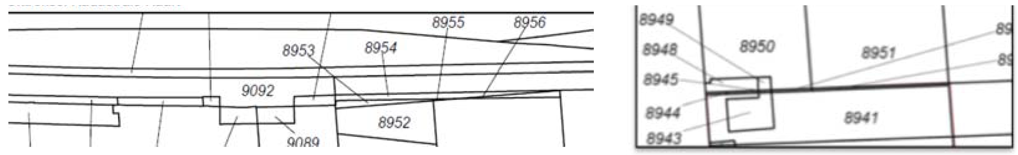
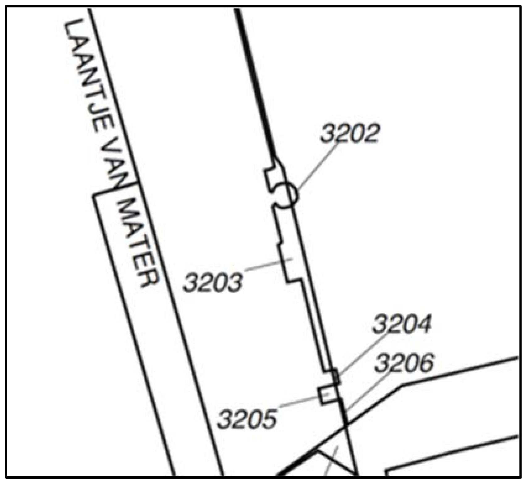
The difficulties (sometimes impossibility) of reconstructing the 3D legal situation from only the description in the deed (in words and accompanying 2D maps), in combination with the 2D parcel boundaries on the cadastral map, have already been experienced in The Netherlands, as can be understood when looking at the complex parcel patterns in
Figure 1.
The very small parcels in this Figure are the result of the projection of the outer-boundary of 3D objects (both above and below ground level) in the 2D map. In this way, existing parcels are subdivided in order to ensure that only the land intersecting with the 3D objects is burdened with a limited right for the object.
To address the issue of subdivision resulting in complex parcel patterns, The Netherlands Kadaster has started a study to improve the registration in such cases [
14].
The implementation of the proposed improvements consists of two phases.
The solution of the first phase was sought within the limitations and possibilities of the existing legal and cadastral frameworks, and aimed at gaining experience in the challenging domain of 3D cadastre where technical possibilities, on the one hand, and legal and cadastral needs, on the other, interact. The aim was to provide a solution for the problem that the rights for 3D volumes can be established, but the dimensional aspect cannot be made visible in the cadastre. Therefore, a procedure was developed to accept 3D representations of legal volumes in a 3D PDF format, as part of the deed. Because of the recently established acceptance of the digital registration of deeds in the Dutch land registers, the registration of a 3D visualisation of multi-level rights in the form of a 3D PDF was possible, without a change of the laws. This method was introduced in practice in 2016, where a 3D visualisation of multi-level rights was registered in the public registers (see the Delft case in
Section 3).
The second phase consists of research in progress and builds on the lessons learned from the first phase. It comprises the study of how to accommodate the explicit registration of rights and restrictions limited in 3D and the actual inclusion of these volumes in the registration, to enable complete validation and to better support 3D data management and dissemination.
This article reports on the results of the first phase (which is the input for the second phase).
3. Multi-Level Property Rights Case I (Delft)
The first multi-level property rights case of this article is the new combined structure of the city hall and underground railway station in Delft.
3.1. Description of the Factual Situation
This building is located in the heart of the Delft Railway Zone project. The Delft Railway Zone covers an area of 24 hectares in total and consists of:
a 23 km long railway tunnel, replacing a partly elevated railway, running along the historic city centre of Delft;
underground railway platforms and station;
station hall with shops at ground level;
the city hall: municipal offices for the city of Delft on four levels;
two underground bicycle parkings (5000 spaces) (and 2700 spaces, under construction at the time of writing);
underground car parking (650 spaces);
new public space, including a park on top of the tunnel and a non-navigable canal for water storage above the car parking; and
urban redevelopment, mainly of former railway yards.
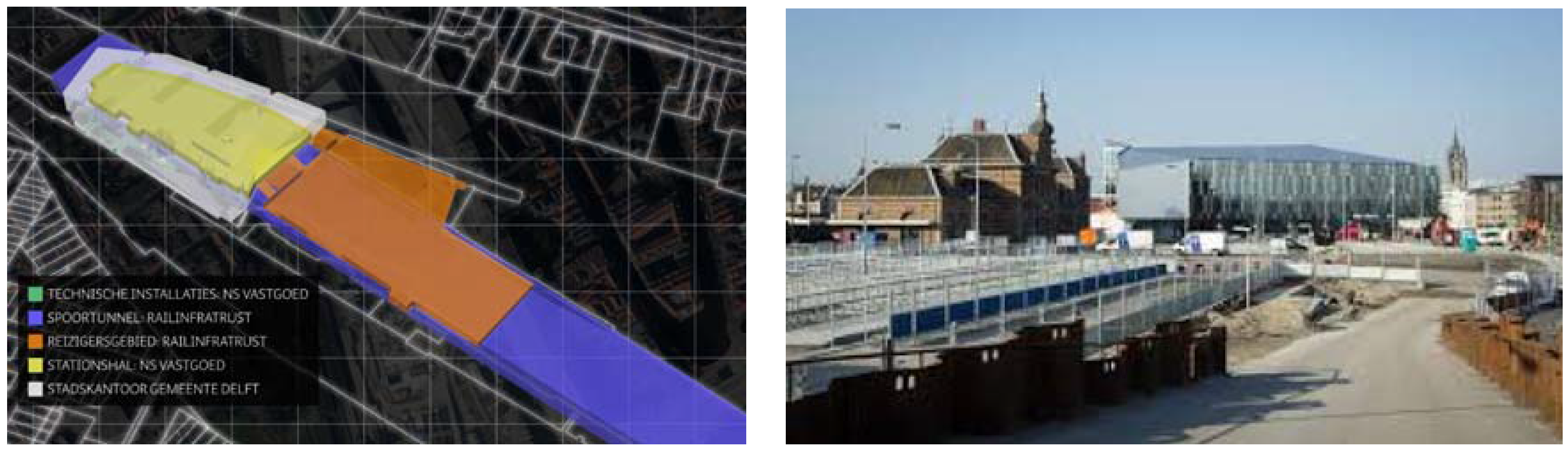
The 3D cadastre case covers only a small part of the total project: the combined new Railway Station and the new City Hall, together with the underground platforms and railway tunnel, several technical installations, and the large underground bicycle parking (see
Figure 2).
The multi-layered construction combines the property rights of three parties: the municipality of Delft as the owner of the land and the City Hall, NS Real Estate (Dutch railroad company for passenger transportation) as the owner of the Station Hall with shops and installations, and ProRail/Railinfratrust (Dutch railroad infrastructure company) as the owner of the traveller’s area, the tunnel, and the platforms. ProRail/Railinfratrust and NS are separate legal entities.
3.2. Registration of Property Rights in 2D
For this multi-level property rights situation, six property rights related to volumes (i.e., legal volumes) have been established:
Station hall (NS Vastgoed);
Traveller’s area (Railinfratrust B.V.);
Elevator and stairs (NS Vastgoed);
Technical installations (NS Vastgoed);
Tunnels (Railinfratrust B.V.);
Municipality of Delft: everything that remains.
The first five property rights were established with a right of superficies. Each of these rights can contain more than one object (space) and can also overlap several ground parcels.
The municipality (sixth property) owns the land and therefore it owns all the space that is left after subtracting the volumes for the rights of superficies (and all buildings that belong to this space, like the office building of the municipality).
The stakeholders in this project agreed that they would register the involved 3D property rights via a 3D deed, based on the model for 3D registration that was developed in Stoter et al. [
14]. However, because the 3D registration was the first one to ever be accomplished, the stakeholders did not want to run a risk of any delay due to the new mode of registration. Any delay in the registration process would have an impact on the moment when the new owners could make use of the new building complex, because the complex can only be used when the rights are secured. Therefore, it was decided that the real rights would first be established via traditional (2D) registration.
For 2D registration, the property rights were established for the different parts of a deed that was recorded in the Land Register. In this deed, the legal volumes were described in wordings, accompanied by 2D maps.
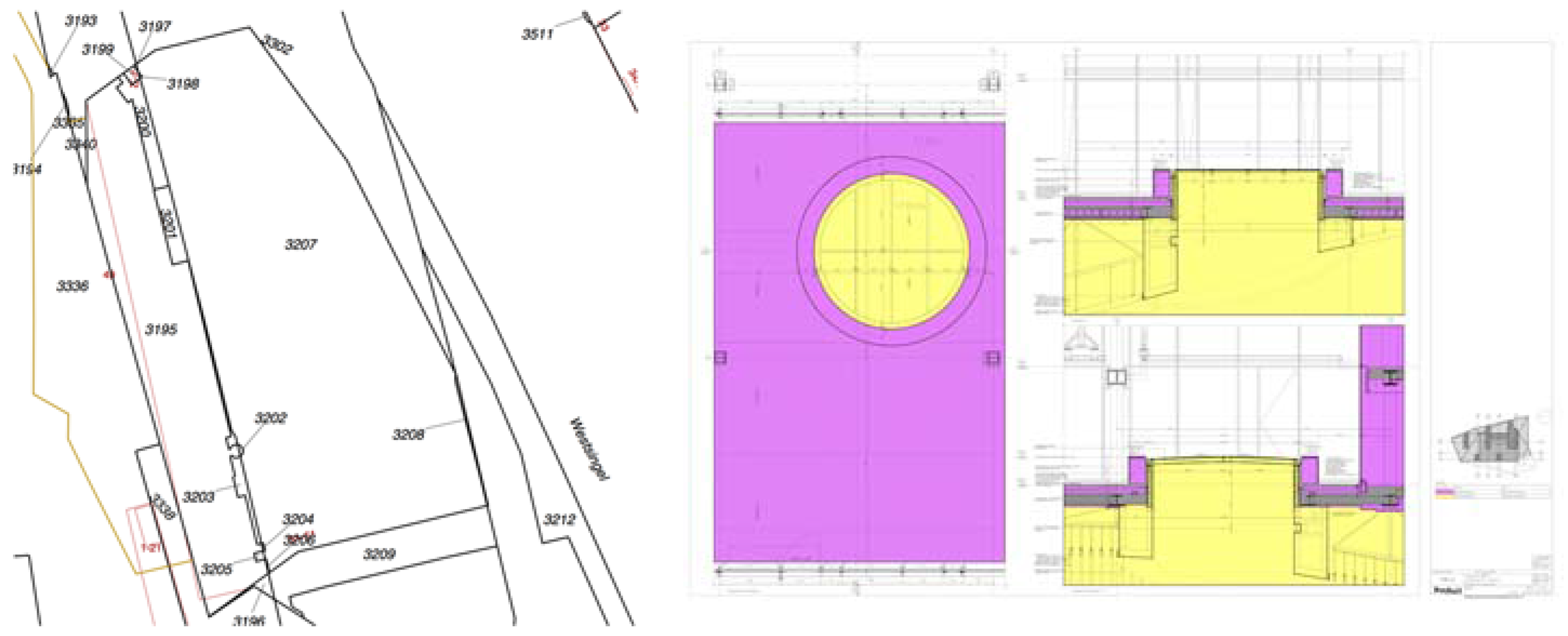
Figure 3 (left) shows the 2D cadastral map at the location and
Figure 3 (right) is an example of one of the 2D cross sections that was added to the deeds to clarify the complex property situation.
In this registration process, new ground parcels were formed by Kadaster, i.e., the original parcels (still reflecting the historical ownership situation before the existing houses and other constructions that have been demolished for the Delft Railway Zone project) were consolidated and were subsequently subdivided in order to specify the different accumulation of rights of the new complex.
3.3. Methodology for 3D Registration
This section describes the procedure that was followed to create the 3D representations of the legal volumes and to register it via a legal 3D deed (i.e., an interactive 3D PDF registered as an official document in the Land Register), as alternative registration.
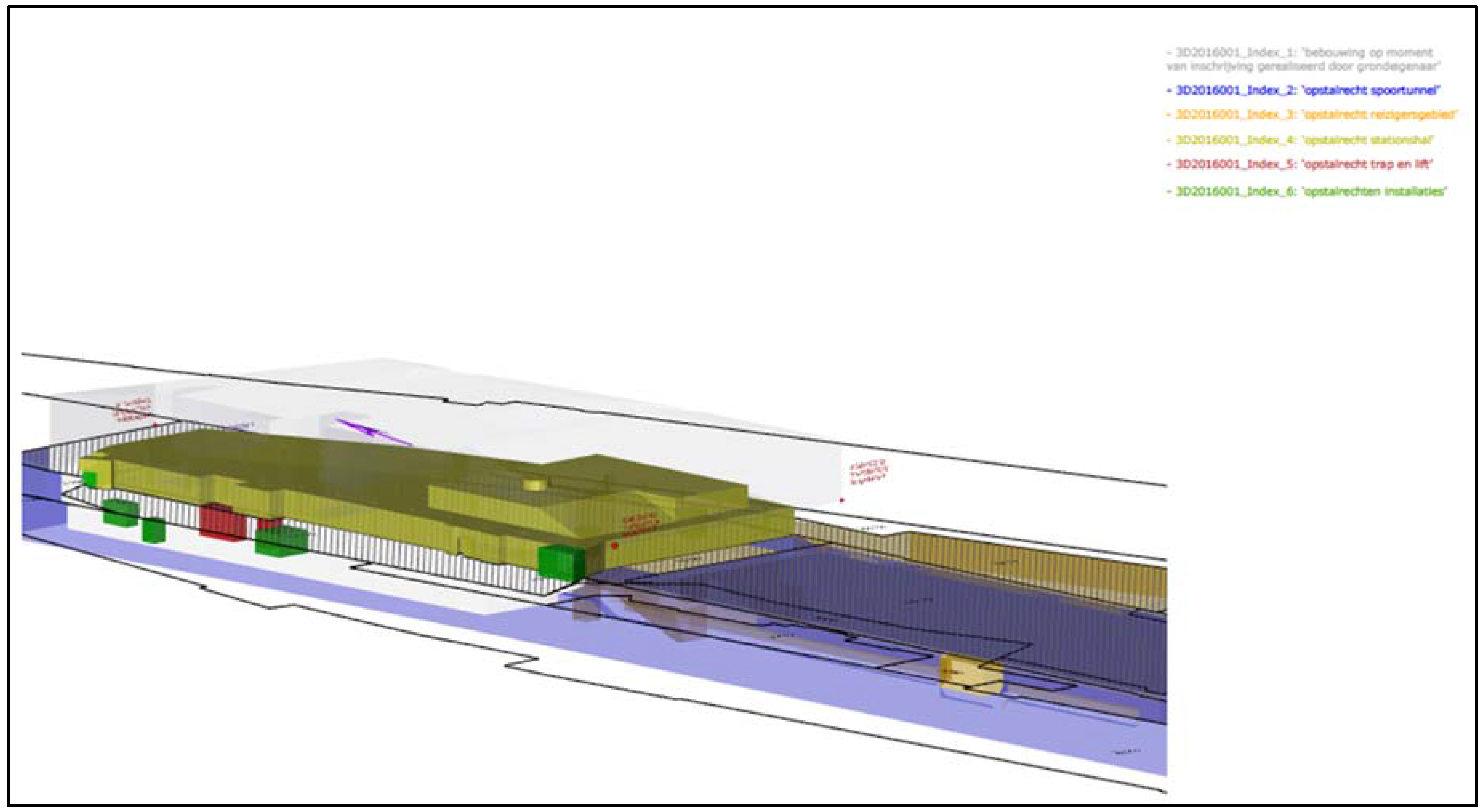
For the 3D registration, the architect of the building complex (Mecanoo) converted the 3D data of the construction itself (the building information model, BIM) into 3D geometries representing the six legal volumes as described above, based on: (a) the design data of the complex; (b) the already registered deed with 2D maps of the complex, and (c) the input of all stakeholders (collected via four work sessions). Several researches have studied how to use BIM for modelling 3D property rights. See, for example, EL-Mekawy [
5] and Atazadeh et al. [
18]. Furthermore, Stoter et al. [
14] have demonstrated the possibility to extract legal volumes from a BIM.
It was decided that the office building of the municipality would be represented, even though the total space owned by the municipality is much larger. That is, the total space owned by the municipality contains all of the space left after the space for the other constructions is subtracted from that. From a legal point of view, this includes the subsurface not occupied by the railway’s tunnel and the underground part of the railway station, as well as the exclusive use rights of the air space above the building. Consequently, the city hall is included in these rights. However, for orientation reasons, it was deemed better to include the building owned by the Municipality in the PDF, be it in a transparent way, to show the difference in status compared to the other parts (legal volumes based on limited real rights).
In a next step, the 3D representations of the rights were translated into 3D PDF. Besides the 3D representation of the rights, some elements were added to improve the usability: a legend of the rights; the 2D cadastral map in which the parcels of concern are identified; and the x, y, and z coordinates of the national reference system that show the location of the complex in the real world.
Finally, the notary firm of Houthoff Buruma has issued a certificate for the deposit of the 3D PDF in the Land Registry as an official deed by the notary (see
Figure 4). This was done supplementary to an earlier deed in which the rights were established and only described in 2D. The actual registration of the document by Kadaster took place in March 2016, setting a milestone in the development of a 3D Cadastre.
In cadastral registration, a 3D complex ID was generated and the different rights were assigned unique indices. These IDs are both registered in the drawing as in the textual part of the deed. However, they cannot be considered to be ‘formal’ parcel numbers as on the traditional 2D cadastral map because this requires a change in the registration framework. Additionally, a reference was made in the cadastral registration to the interactive, 3D visualisation of property rights in 3D.
Finally, the 3D data itself (describing the 3D geometries of the legal volumes) are stored by Kadaster in view of future needs that may require the juridical situation to be adjusted. The 3D data is stored (and maintained) by the public registers.
3.4. Accessing the 3D Registration
The multi-level property rights can be queried in 3D via cadastral registration: the registration shows a parcel complex on the cadastral map with a notification of “3D visualisation”. This notification refers to the deed with the 3D drawing. This 3D PDF is publicly available, not only from the public registers, but also from Kadaster [
19], and can be viewed in any PDF viewer that supports 3D. In the viewer, the 3D situation can be interactively viewed, and one can see the relationship between the different legal volumes (which cannot be done if they are registered via separate 3D surveys), generating individual volumes that are visible (or invisible) for further inspection. When “clicking” on objects, one sees the 3D-indices and owners of the volumes.
4. Multi-Level Property Rights Case II (Amsterdam)
After the 3D registration of the Delft case, another multi-level property rights case was considered. The second case of this article is the new combined structure of the large Congress hotel Maritim, a residential building, and an underground parking garage in the northern part of Amsterdam. The creation of the 3D PDF visualising the legal volumes is a collaboration of Kadaster, Bentley, and Delft University of Technology. The 3D PDF was created to study an alternative method to for the 2D registration, but more importantly, to use the experiences of this case (together with the Delft case) as an input to describe a standardised workflow for future 3D registrations. The actual registration in the cadastral registration of this case is future work.
4.1. Description of the Factual Situation
The congress centre can host 5000 visitors on the first three floors and has a hotel on top with about 580 rooms, with a number of bars and restaurants. It also contains a fitness area that can be used by both hotel guests and the inhabitants of the residential building. The buildings were designed by Team V Architectuur.
4.2. Registration of Property Rights in 2D
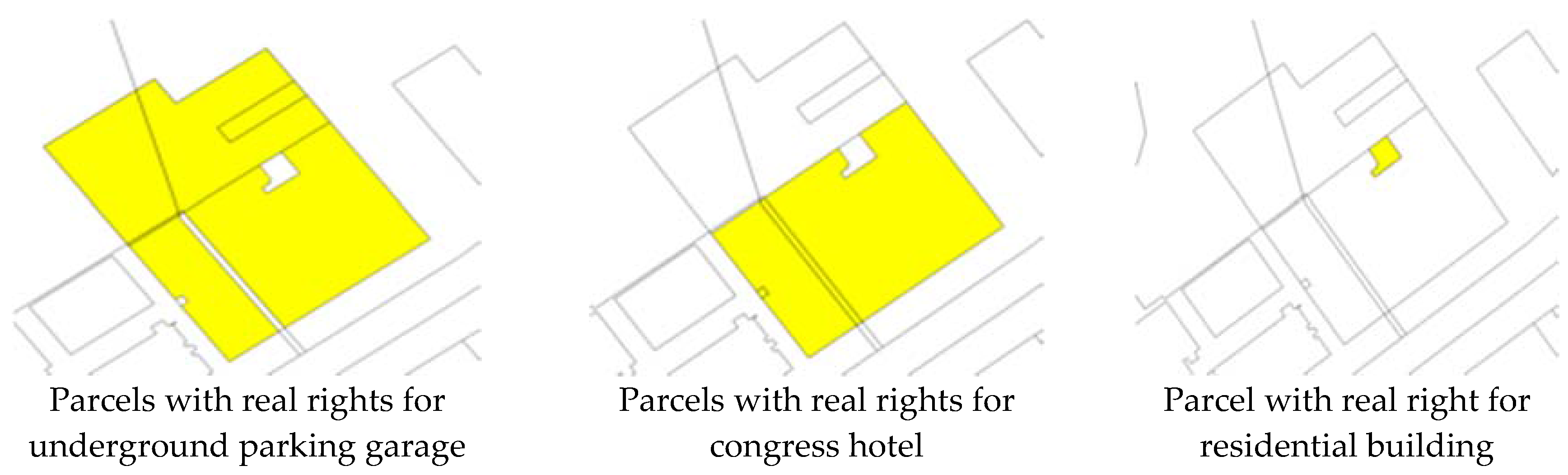
For this building complex, three legal volumes have been established:
Underground parking garage with a right of superficies (
Figure 5, left)
Congress building and hotel with a right of ground lease (
Figure 5, middle)
Residential building, with a right of ground lease (
Figure 5, right)
The municipality of Amsterdam is the land owner and therefore owns all of the space that is left after subtracting the volumes that comprise the rights of superficies and the two rights of ground lease.
The parcels that are affected by the legal rights of the three respective property rights are shown in
Figure 5.
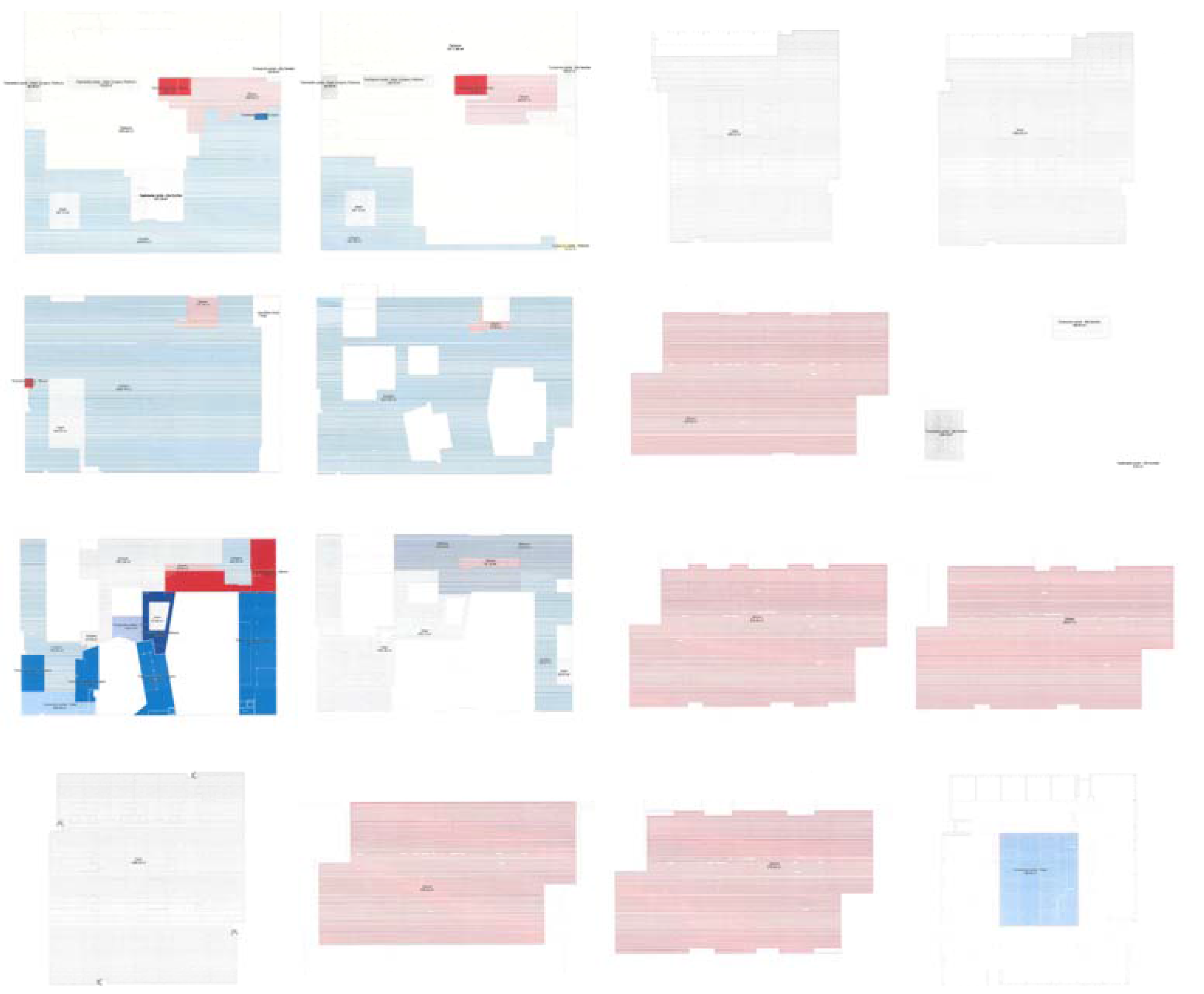
To show the extent of the rights in the deed, an 2D overview of every floor was generated and added to all three deeds (underground parking garage, congress hotel, and residential building). As can be seen from
Figure 6, it is a mental challenge to combine those floor plans into a (mental) 3D view that shows the extent of all the legal volumes involved.
4.3. Methodology for 3D Cadastral Registration
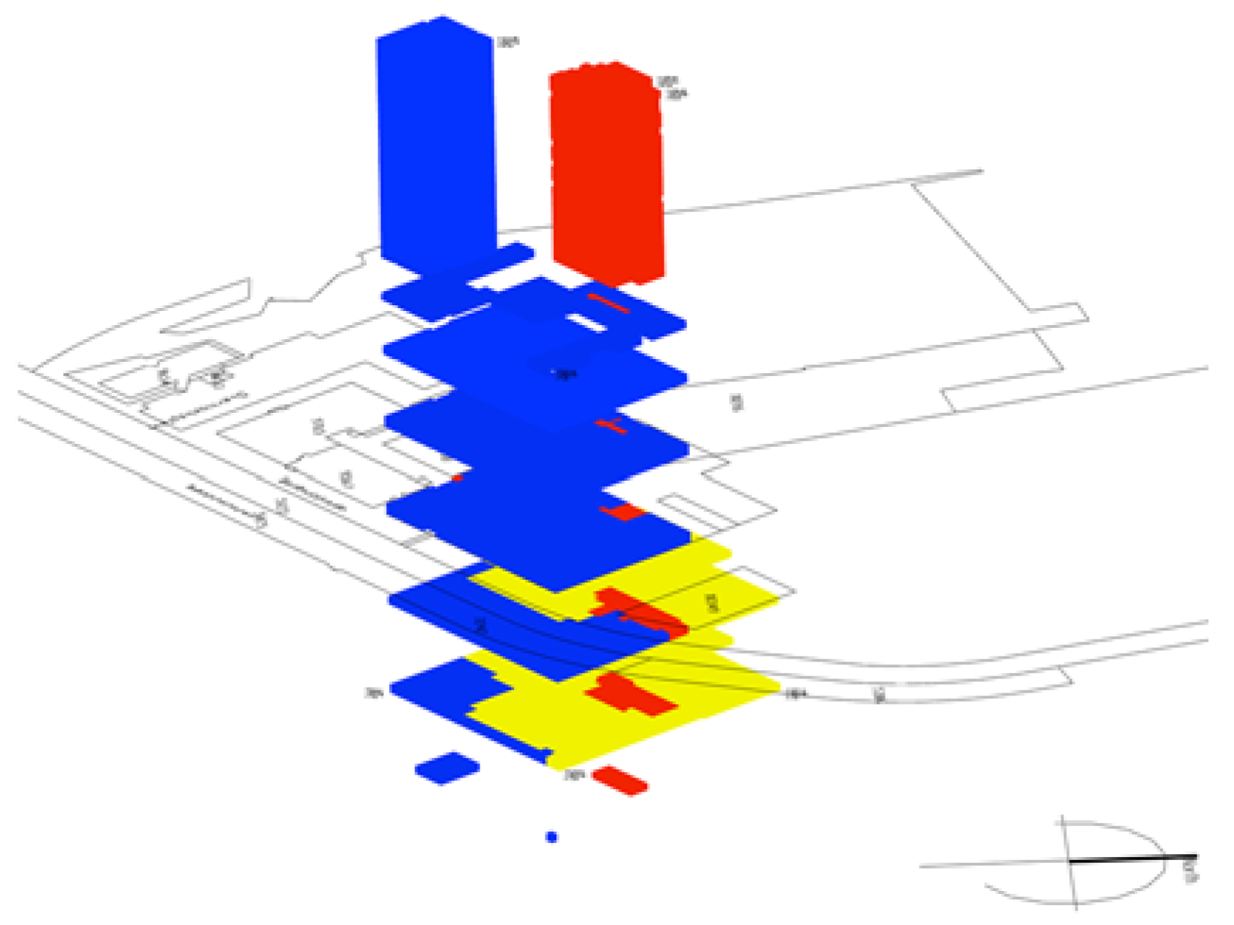
To prepare for alternative 3D registration, we collaborated with the architect of the building complex, Team V Architectuur. From the 3D design data, volumes were created, representing the legal entities. These were used to create the 3D PDF.
A few improvements were made based on the evaluation of the 3D visualisation of the Delft case. This first user evaluation showed that navigating in a 3D PDF is not straightforward. Therefore, different views on the 3D building complex were generated so that users can easily switch between different viewpoints in the 3D PDF to understand the situation (e.g., top view, different side views, etc.).
Additionally, an exploded view was prepared from the data and added to the 3D PDF. This view gives a clear impression of how different legal entities on different heights interfere, with little user interaction needed (see
Figure 7).
Finally, we performed data quality checks. This is important because the 3D geometries are generated by the architect, with no involvement from Kadaster. Kadaster has to check that the generated geometries indeed represent the legal volumes as agreed by the stakeholders. Therefore, the first step included integrating the legal volumes created with the original design data.
This integrated view (see
Figure 8 and
Figure 9) showed that both the balconies of the residential building, as well as the façade of the Maritim Hotel tower, had been excluded from the initial legal volumes. To repair this, a new boundary had to be reconstructed, enclosing the complete physical model for the final version of the legal volumes.
Another data quality check that we performed was the tightness of legal volumes, i.e., there should be no overlap or gaps, by using tools in Bentley Map Enterprise. We identified all volumes to be watertight (i.e., closed), with no overlap or gaps. These requirements are basic for cadastral applications and are in 2D. However, in 3D, checking the validity of 3D geometries is not trivial. See Karki et al. [
8], Thompson and van Oosterom [
20], and Ledoux [
13] for examples.
A final data quality check included matching with the 2D cadastral map that is included in the 3D PDF for reference purposes (to identify which parcels are affected by the 3D registration). This required georeferencing the legal volumes that were generated from the design data.
Georeferencing is a manual process (it requires localisation and scaling) and can therefore easily lead to errors. It is, however, important that any mismatches between the 3D legal volumes and the 2D parcel boundaries are avoided.
5. Results of 3D Registration
In this section, the 3D registration is evaluated (
Section 5.2). First, the developed workflow is presented (
Section 5.1).
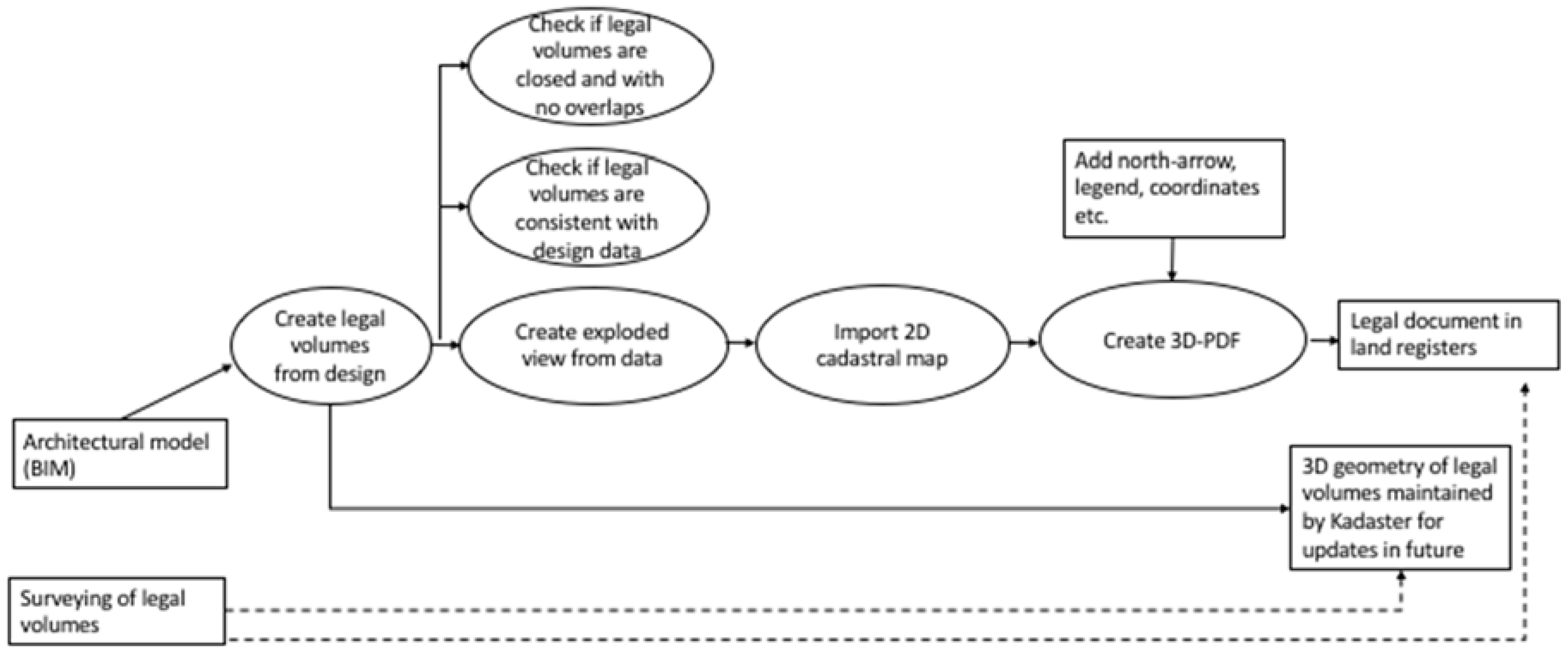
5.1. Developed Workflow
Based on the experiences of these two cases, we have defined the workflow to create a 3D PDF that acts as an interactive visualisation of the legal volumes in the case of a multi-level property situation. This workflow can be used in future situations and is shown in
Figure 10.
The workflow has two possibilities for creating the geometries of the legal volumes: (1) surveying (which is only possible in the case of a physical construction that already exists) and (2) from the architectural model (this article). The first option (surveying legal volumes) represents future work. Checking whether legal volumes are consistent with their physical counterpart, as well as if they are watertight with no overlap, is also part of the workflow.
The 3D PDF contains the 3D geometries representing legal volumes, the 2D cadastral map of the situation, and some additional aspects such as a north-arrow, legend, and real world coordinates. An exploded view is also created to better present the situation (see
Figure 7). Finally, 3D data relating to the geometry of the legal volumes is maintained to be able to update the document in the future.
5.2. Evaluation of Implemented 3D Registration
A comparison of the two types of registration (i.e., 2D and 3D) for both cases shows the significant advantages of 3D registration in the case of multi-level property situations.
At first, complex multi-level property rights can be made more (and sometimes ‘only’) clear in 3D.
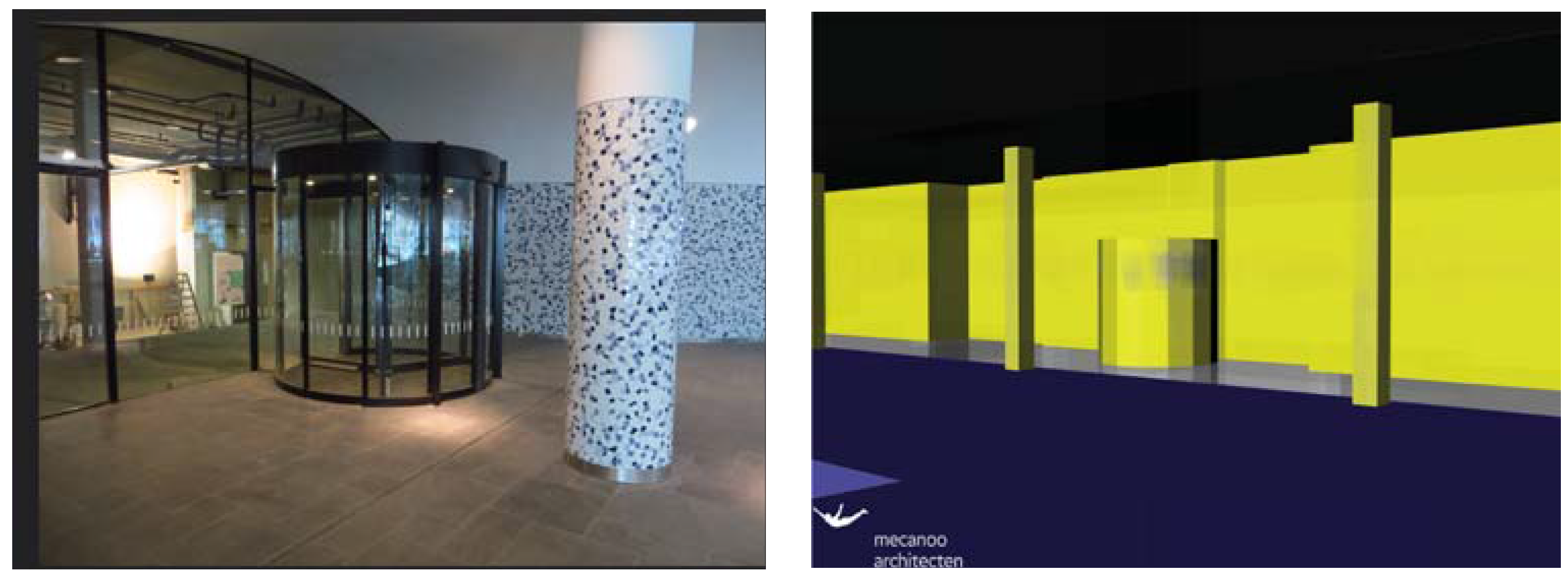
An example of this is a revolving door in the Delft case (
Figure 11): the revolving door between the station hall (owned by NS) and the city hall (owned by the municipality). The construction extends into the property of NS, but does not extend to the ceiling. Therefore, the question arises: to whom does the space belong from the top of the revolving door to the ceiling? This situation can only be clarified in 3D.
Moreover, for the building complex of the Amsterdam case study, the 3D approach provided more insights than the 2D drawings used for the registration. All legal volumes are integrated in one environment, and therefore, one view is sufficient to understand the ownership situation, instead of mentally combining 14 floor plans in one 3D situation.
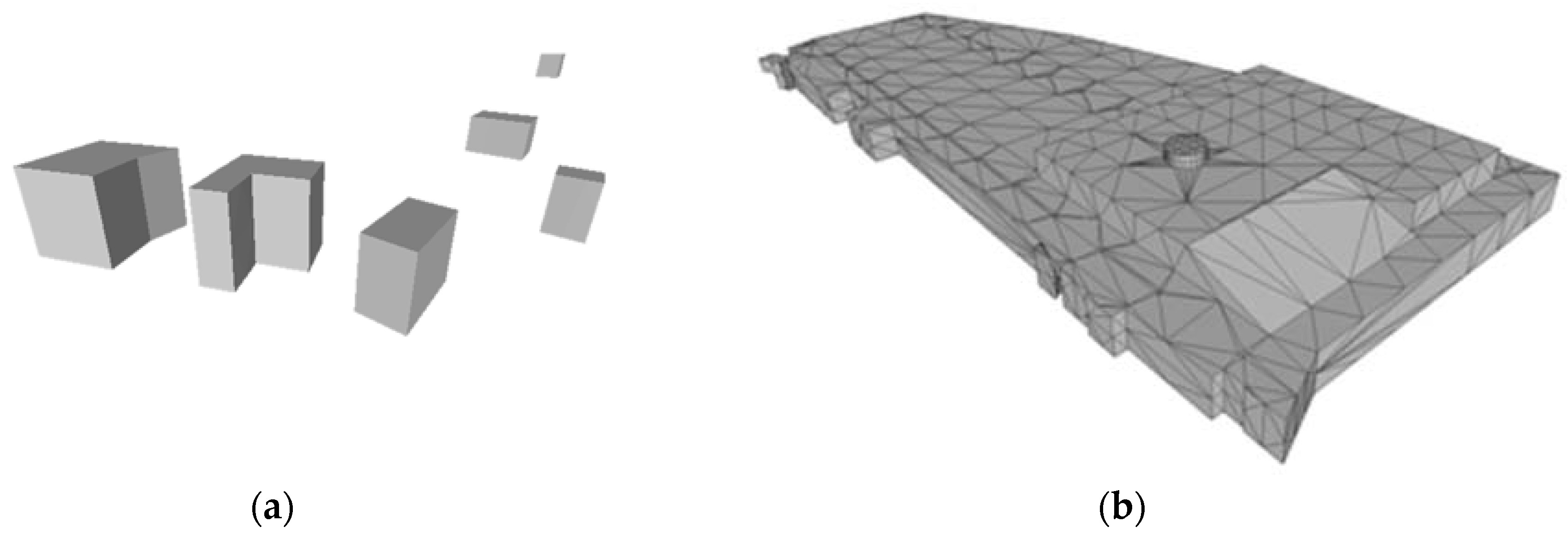
Another example of why 2D cannot sufficiently represent the property rights in complex situations demonstrates that the conversions of the 3D data relating to the physical construction into legal volumes revealed some errors in the 2D registration.
An error that appeared in both cases is that not all parcels intersecting with the 3D objects were encumbered with limited property rights. Furthermore, tiny parcels were created because of a mismatch between the location of 2D cadastral boundaries and the projection of the 3D reconstruction. The mismatch was not due to a wrong location of the involved objects (parcels on the one hand and 3D (BIM) objects on the other hand), but due to a difference in accuracy. The design data has a higher accuracy than the cadastral map and integrating both resulted in unneeded, and as we might call them, “artificial”, parcels (
Figure 12). The 2D cadastral map was therefore improved with this new information.
Another advantage of 3D above 2D, is that—at least in the Dutch context—the registration is more cost effective.
First, this is because the cumbersome process of describing the complex situation in a 2D description required for the registration can be skipped. This also applies vice versa: 3D reconstruction of the legal situation from a sub-optimal registration required for future transactions is not needed. However, the costs of surveying can also be saved because the surveying of ground parcels within complexes is no longer necessary to assure that the 2D parcel map reflects the 3D situation. These costs may be significant in cases of multi-level property rights where boundaries are not exactly on top of each other when projected on a 2D plane. Specifically, those situations produced issues among the stakeholders in the first case: who has a right to the very tiny parcels that were created by projecting objects above and below the surface in a 2D plane? This also led to insights that the 2D map does not reflect the correct situation and it was therefore improved (see before).
In conclusion, a 3D cadastral registration of multi-level property rights has many advantages. However, the fact that the 2D cadastre map no longer reflects the legal situation, but refers to a 3D registration that does, requires a change in the cadastral legislation and procedures, as will be elaborated in the next section.
6. Next Phase of 3D Cadastre Registration
The optimal solution for adequately registering multi-level property rights in the cadastral registration lies somewhere between current registration (with lots of additional information needed such as text and 2D drawings to explain the situation) and the implementation of a full 3D cadastral registration [
21].
In the full 3D cadastre, the 3D space (universe) is subdivided into volume parcels partitioning the 3D space [
21]. The legal basis, real estate transaction protocols, and cadastral registration support the establishment and conveyance of 3D rights. There is no longer a 2D cadastral map that lays down restrictions on 3D rights. Every property right is treated as a volume and these are not related to the surface configuration of parcels.
Although a full 3D cadastre would in theory meet all needs to establish and register multi-level property rights, it is not the aim of our research. At first, a full 3D cadastre would require a change of the existing framework in cadastral law (Kadasterwet), as well as the land law, as laid down in the Dutch Civil Code. Changing the legal framework is a lengthy process. In addition, cadastral registration has been based on 2D parcels for a very long time and it is hard to predict how a full 3D cadastre would work in this well-established practice. Changing from a 2D parcel-based concept to a 3D parcel-based concept would also mean re-surveying and re-registering millions of existing situations. Finally, the current 2D cadastral registration still serves single property situations very well. Therefore, the optimal solution for practice is an interchange of juridical, organisational, and technical aspects.
To avoid lengthy discussions between experts from different disciplines on the optimal implementation of a 3D cadastre, the solutions presented in this article were sought within existing legal and cadastral frameworks, with the aim of further developing the solution after an evaluation of these first 3D cadastral cases.
This section evaluates the above described 3D registrations for future developments.
6.1. Juridical Expertise Is Required to Create (or Validate) Legal Spaces from Physical Model
In both cases described in this article, the technical drawer of the architect’s office actually created the boundaries of the legal volumes based on the technical 3D design of the construction. The lack of juridical knowledge of the people involved may result in an incorrect reconstruction of the legal volumes, as occurred in the Amsterdam case. Therefore, for future registration, Kadaster needs to request additional information to validate the legal volumes, for example, visualisations that show that the physical objects are consistent with the legal volumes and how these (spatially) relate to each other.
6.2. 3D Drawing to Support the Complete Registration Chain
The advantages of a 3D drawing can only be fully realised if the 3D drawing is part of the registration process from the start.
As was mentioned above, in both cases, the stakeholders decided to first register the property rights in a “traditional” (2D) way. This was necessary to secure the rights before the construction of the building was completed. The 3D registration was new and therefore would take (much) longer than the traditional mode of registration in which all of the steps to follow are clear (although resulting in an unclear registration).
To realise the traditional 2D registration, the legal reality was first made “flat” (i.e., described in 2D) and then had to be reconstructed again in 3D from the existing documents. As could have been expected, this resulted in grey areas without an explicit ownership in the deed. A 3D approach from the start would have avoided these grey areas. However, more importantly, it would have saved substantial time in the process (a significant advantage of 3D above 2D), because the 3D reconstruction of complex situations from 2D descriptions would not have been needed.
6.3. Reconsidering the “Speciality Principle”
Another lesson learnt relates to the “speciality principle” followed by Dutch land administration (which is also applicable in many another countries). This principle prescribes that the original parcel needs to be subdivided if a limited right is only established on part of a parcel, in order to assure that parcels that do not intersect with (the projection of) other properties are not affected by a limited right. Because of this principle, the building complex of the Delft case (
Section 3) needed to be divided into 15 cadastral parcels and in the Amsterdam case (
Section 4), 14 parcels were required. However, the initial idea was not to divide the ground parcel. The speciality principle, as observed in the traditional 2D registration, is a significant problem for multi-level property situations, since considerable time is needed to understand the property situation of these small parcels, specifically at those locations where the tunnel of the first case crosses small objects above ground. As we saw in
Section 3.2, errors were even detected in the 2D parcel boundaries when the 2D cadastral map was confronted with the much more accurate BIM data. Maintaining the original parcel and not dividing it into small parcels, but instead referring it for the exact location to the 3D volumes in the 3D PDF, avoids these problems.
Current techniques show that there are better ways to provide insight into multi-level property rights than dividing parcels into smaller parcels. Therefore, it is indeed recommended that only one parcel is registered in such cases where the 3D visualisation of the 3D property rights of the whole complex is registered. For Dutch law, this requires a change of the Kadasterbesluit (Cadastre Decree) stating that surveying within a building complex is not needed, if all rights within the complex are represented in 3D. As argued before, this change will also save costs.
Apart from the registration of property via parcels, it is already possible in The Netherlands (as in many other countries) to register specific object types as independent objects with their own geometry, like cables and pipelines (see [
22,
23]).
6.4. 3D Parcels
The legal volumes formed with real rights overlapping with several ground parcels, can be considered as 3D parcels according to the definition of (Van Oosterom et al. [
24]):
“A 3D parcel is defined as the spatial unit against which (one or more) unique and homogeneous rights (e.g. ownership right or land use right), responsibilities or restrictions (RRRs) are associated to the whole entity. Homogeneous means that the same combination of rights equally apply within the whole 3D spatial unit. Unique means that this is the largest spatial unit for which this is true. Making the unit any larger would result in the combination of rights not being homogenous. Making the unit smaller would result in at least two neighbouring 3D parcels with the same combinations of rights.”
The legal volumes meet this condition and are registered with their own ID. A next study should address the following questions. What is that status of the 3D legal volumes? Can they be treated as single (new) 3D parcels, i.e., as individual objects? Or, do they always need to be linked to a 2D parcel?
6.5. Legal Boundaries Versus Physical Boundaries
Another lesson learned is that juridical boundaries in 3D are not always bound by physical boundaries. For example, we had to agree on how to demarcate the property of the space that accommodates the (use of a) staircase; only the visualisation of a constructed building is not sufficient. The division between the different rights in relation to the physical objects needs to be unambiguously clear to assure legal certainty.
6.6. Registration of the 3D Data
There is also a lesson to be learned from the registration of the 3D data needed for validation and updating in the future.
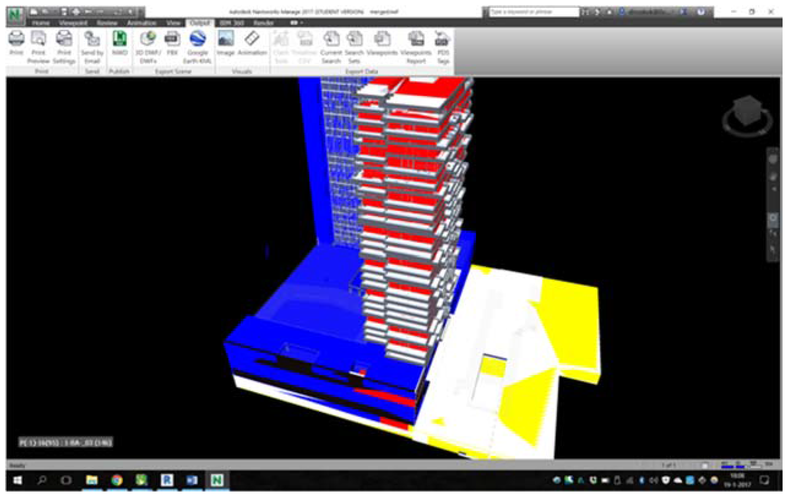
The legal volumes have been drawn originally in a specialised CAD software (Rhino 3D in the first case; and Autodesk Revit in the second case) and exported to a 3D PDF for everyone to inspect and visualise. In the specialised software, we ensured that the volumes were closed (i.e., “watertight”) and that they were valid. This could be done with functions available in the software.
However, since our ultimate aim is to register these rights and allow everyone to manipulate the geometries, we did some experiments to store the geometries of the legal volumes in a format that is open and easily readable.
Here, we explain our experiments for the first case. The first case has six property rights, and each of them can consists of multiple volumes. The legal volumes for one of the rights can be seen in
Figure 13a; in total, there are seven of them and they refer to the green ones in
Figure 4. Most are rather simple volumes, but some are more complex, such as the one on the right in
Figure 13b (which is the green volume in
Figure 4).
Several challenges were faced when trying to obtain the legal volumes in an open standard. First, the export function of the software modified the boundaries of the volumes, by adding several vertices on the surfaces and edges (presumably to translate the parameterised geometries of the CAD software into explicit geometries), as shown in
Figure 10 on the left. While in theory these challenges should not be an issue, the software inserted these very close to each other at certain locations (at the sub-millimetre level), which can be problematic when imported in different software. Second, the definition of what is a valid volume is different in different software and in different disciplines, as Ledoux [
13] explains. In a GIS context, the ISO 19107 standard defines a solid (a 3D volumetric primitive) as a closed volume, and there should, for instance, not be any self-intersections in the bounding surfaces and no duplicated vertices. Unfortunately, in CAD software, self-intersections are sometimes allowed. This means that when we validated the volumes against the ISO 19107 rules, some of the volumes were invalid. The solution to this problem is to decompose the volumes into sub-parts, for example, if GML (Geography Markup Language) was used, then CompositeSolid would be used. Part of the future work will define a workflow so that practitioners can export their legal rights and store them in valid GML.
7. Questions for Further Research
Based on experiences from the first phase, investigations focusing on how to establish a more formal procedure for the 3D registration of multi-level property rights are currently underway. In these investigations, the following issues need to be addressed:
Can the Kadaster enforce such a 3D registration in certain situations and if so, in which cases?
What is required if 3D needs to be part of the registration from the start? Based on the experiences of these two cases, we have defined a workflow that explains all of the steps required to convert a BIM model into legal volumes and to write these to a 3D PDF with specific requirements. This also covers the export from legal volumes constructed in CAD software to valid GML.
How does one change the legal rule so that one parcel can be registered for one multi-level property rights situation instead of dividing the 2D parcels to reflect constructions above and below the surface?
What is the legal status of the 3D visualisation? Is the visualisation additional to the deed (3D is leading) or is the visualisation only meant to clarify the 2D deed only (2D is leading). If the 3D deed is leading, then the 3D data need to be validated via an official procedure. How does one implement these procedures? Asking for additional information to show the consistency between legal volumes and their physical counterpart can contribute to the quality procedure. In addition, Kadaster can require a proof of the geometric validity of each volume (as can be tested in different software).
What are the (minimum) requirements for the 3D visualisation?
What does one do if there is a difference between the deed and the 3D visualisation?
What is the relationship between 2D and 3D (should the 3D visualisation always fit within 2D registration)?
How does one maintain the underlying 3D data?
The 3D PDF is registered as a legal document. Does this document need to be updated if a (small) part of the multi-level property case is changed?
8. Conclusions
In this article, we presented the first 3D cadastral registration of multi-level property rights in The Netherlands. Although it has been possible to legally establish 3D rights for centuries, until recently, it was impossible to visualise these 3D rights. Since, on the one hand, technologies required to handle 3D information have matured, and on the other hand, multi-level property rights situations are encountered that cannot be unambiguously registered in the current 2D based system, Kadaster (in collaboration with the Delft University of Technology) has developed a methodology to improve the registration in multi-level property rights situations through the use of a 3D PDF. This article presented the methodology for two real-world cases. The first case was also officially registered in the land registers in March 2016, setting a milestone in the development of a 3D Cadastre.
As can be concluded from the results, a 3D registration of multi-level properties, as implemented in this project, provides better insight into the case of multi-level ownership. It is no longer required to infer the 3D legal situation from 2D maps and verbal descriptions. Some legal situations can even only be shown in 3D.
The 3D PDF can be registered as a legal document in the land registers, as was done for one of the two cases presented.
Based on the experiences of the 3D registrations presented in this article, the 3D registration will be further developed and the regulations will be adjusted accordingly.
The step from 2D to 3D is not only providing insight into 3D via an available 3D technique such as a 3D PDF. Instead, the most challenging aspect is to assign a 3D geometry to legal volumes with possibly the same juridical value as parcel boundaries in 2D (or not). For cadastral registration, this requires a new way of defining, validating, and maintaining information about property rights in the cadastral registration.
The optimal 3D cadastre solution is a trade-off between juridical, cadastral, and technical aspects and we cannot predict how these aspects best come together. Therefore, the further development of 3D registration will be researched and the results of each step will be evaluated with cadastral, technical, and legal experts before the next step is made.

 ,
, 


