Article

Promoting Environmental Justice through Integrated Mapping Approaches: The Map of Water Conflicts in Andalusia (Spain)

Human Geography Department, Universidad de Sevilla, 41004 Sevilla, Spain
*
Author to whom correspondence should be addressed.
ISPRS Int. J. Geo-Inf. 2020, 9(2), 130; https://0-doi-org.brum.beds.ac.uk/10.3390/ijgi9020130
Submission received: 20 January 2020 / Revised: 14 February 2020 / Accepted: 20 February 2020 / Published: 22 February 2020

Abstract

:
Addressing environmental governance conflicts requires the adoption of a complexity approach to carry out an adaptive process of collective learning, exploration, and experimentation. In this article, we hypothesize that by integrating community-based participatory mapping processes with internet-based collaborative digital mapping technologies, it is possible to create tools and spaces for knowledge co-production and collective learning. We also argue that providing a collaborative web platform enables these projects to become a repository of activist knowledge and practices that are often poorly stored and barely shared across communities and organizations. The collaborative Webmap of Water Conflicts in Andalusia, Spain, is used to show the benefits and potential of mapping processes of this type. The article sets out the steps and methods used to develop this experience: (i) background check; (ii) team discussion and draft proposal; (iii) in-depth interviews, and (iv) integrated participative and collaborative mapping approach. The main challenge that had to be addressed during this process was to co-create a tool able to combine the two perspectives that construct the identity of integrated mapping: a data-information-knowledge co-production process that is useful for the social agents—the environmental activists—while also sufficiently categorizable and precise to enable the competent administrations to steer their water management.

1. Introduction

1.1. Participatory and Collaborative Mapping at the Service of Environmental Justice

As defined by Brown and Kyttä [1] (p.1), participatory mapping refers to multiple ways that experts, individuals, or local communities interact to create and communicate knowledge, experience, and aspirations about the world in maps. By proposing this definition, they intentionally group a range of practices that—in the realm of Geographic Information Systems (GIS) can have different names, origins, and applications, such as public participation geographic information system (PPGIS), participatory GIS (PGIS), and volunteered geographic information systems (VGI).
For the purpose of this article, in which we present an experience of designing and implementing a web-map of water conflicts in Andalusia, southern Spain, we find it useful to distinguish between participatory mapping, such as the mapping processes that involve face-to-face public participation inputs, and collaborative mapping projects that are mainly focused on gathering and disseminating geographic data, provided voluntarily by individuals who act as “voluntary sensors” [2]. Accordingly, following Liu et al. [3], we distinguish between community-based participatory mapping processes and collaborative mapping practices mainly related to volunteered geographic information systems and web mapping applications.
These latter practices have also been framed in the broader theoretical framework of citizen science [4], which adopts the collaborative mapping method in the case of voluntary citizen contributions to geographic and cartographic information. Over the last two decades, increasing interest in these mapping experiences has evolved significantly from diverse application domains, in the recognition that the use and integration of non-expert, place-based knowledge and experience can help address complex land use problems, and enhance valued, legitimized, and sanctioned searches for solutions [1,5,6].
Participatory mapping projects have proliferated throughout the world since the 1990s, ranging from those conducted by relatively prosperous urban groups in northern Europe and America to forest-dwelling indigenous groups in the tropics [7,8,9]. In most—but not all—cases, the critical vocation of participatory maps aims to generate spaces for a collective exchange of narratives and representations that dispute and challenge the logic of hegemonic discourses [10]. In this sense, participatory mapping can contribute to uncovering hidden power structures, building maps in which conventional and hegemonic representations overlap with vernacular information and knowledge otherwise made invisible by the dominant discourses. In this way, participative and critical maps aim to contribute to the processes of empowerment and appropriation of space by citizens and/or local communities as a necessary condition for social change [11] (p.11) [12]. As they highlight hidden and alternative understandings of the world, they also become “potential objects of policy and politics” [13] (p. 620) in [14] (p. 273).
Since its early stages, a consistent aspiration of this kind of participatory mapping has been to engage and empower marginalized groups in society through the use of spatial technologies, which have become a useful tool for environmental justice movements to transmit and report environmental conflicts, and uneven socio-ecological damage [15,16,17,18,19,20,21,22]. Founded in this theoretical context, the design, and elaboration of the webmap of water conflicts in Andalusia has been based on cooperative research and knowledge co-production through an integrative process of the “instrumental” and “empowerment” perspectives [23], while implementing an integrated participatory-collaborative mapping approach [3], as discussed in the following sections.

1.2. Hypothesis, Objective, and Case Study

Addressing environmental governance conflicts requires the adoption of a complexity approach designed to trigger an adaptive process of collective learning, exploration, and experimentation [24,25,26]. Indeed, when facing different social and complex issues, analytical processes need to be associated with reflective and experimental thinking to fully tackle system dynamics. For this reason, there has been a growing consensus over the past two decades that participatory and inclusive processes are necessary for effective and fair decision-making in the specific arena of water governance [27,28,29,30].
In previous works, the outcomes of the participatory processes have been evaluated in relation to their effective influence on public policy—the public’s ability to influence the final plan or, in other words, how decision-making power has been restructured—while also taking into account some criteria derived from the process [12,31]. This is the case of the work by Ballester and Mott [32], who evaluate adaptive capacity building in two different water planning processes—the Ebro River Basin (Spain) and the Tucson Basin (Arizona, US)—through several indicators related to the implementation of the process, such as learning, knowledge, collective vision, willingness, networks, trust, and continuity. The rationale behind this approach is to identify the potential benefits recognized in many implemented participatory processes for water planning, such as the ability to foster collective learning and understand issues [33,34,35,36], and the ability to increase community cohesion and collective identity [37].
In this article, we hypothesize that by integrating community-based participatory mapping processes and internet-based collaborative digital mapping technologies, spaces can be created for knowledge co-production and collective learning [3,38]. We also argue that providing a collaborative web platform enables these projects to become a repository of activist knowledge and practices that are often poorly stored and seldom shared across communities and organizations. As such, these web-based collaborative maps can be useful tools to monitor, document and take stock of “dissensus-driven practices and methods” as “living indicators” or “signposts of what needs to be urgently addressed and where” [39]. The collaborative Map of Water Conflicts in Andalusia, Spain (hereafter Map-RedNCA using its Spanish acronym, Red-Nueva Cultura del Agua) is used to demonstrate the benefits and potential of these kinds of mapping processes. This case study is located in the southern region of Andalusia (Spain), an area of 87,268 km² and 8,414,240 inhabitants in 2019.
The goal of the Map-RedNCA participatory tool is two-fold: (i) to promote action research in environmental justice and support the work of social movements through the creation of outreach material to document and make conflicts, debates, and social initiatives around water visible in Andalusia, and (ii) to serve as a potential tool to channel public participation in institutional water planning cycles. One of the outcomes could be its use to help identify “significant water management issues” around, which the social debate at the beginning of each planning cycle of the river-basin districts should be articulated: “Member States shall ensure that, for each river basin district, they publish and make available for comments to the public […] b) an interim overview of the significant water management issues identified in the river basin, at least two years before the beginning of the period to which the plan refers” [40] (art.14, 1.b).
After a two-year construction process, the Map-RedNCA has been operational since mid-2019 and already includes approx. 53 reports (Figure 1).
Building on previous experiences, especially that of the Environmental Justice Atlas [14,41], the purpose of the Map-RedNCA is to provide a tool for activism and social resistance; to promote dialogue and an exchange of experiences, ideas, data, and strategies; to provide a source of information with specific, relevant, and consistently systematized cases; to sensitize the media and public opinion itself; to exert pressure on policymakers to implement public policies aimed at environmental justice; to develop and strengthen strategies for articulating environmental justice policies, and to contribute to knowledge co-production processes [14] (p. 264). However, unlike the Environmental Justice Atlas, which aims to report all types of global environmental injustice around the world, our project is focused on a regional scale and one specific thematic issue: the reporting of cases of water injustice. The thematic focus and the locality are important factors to understand the more direct and narrow involvement of local social agents in the process. These two characteristics also facilitate the integration of the webmap into the pre-existing webpage of a social organization, which is another of its differentiating features.
The specific objective of this article is to analyze the extent to which constructing the webmap and its outcomes also serve as a knowledge co-production and collective learning process, due, especially, to the methodological focus applied, and the map’s integration into the structure of the region’s social movements. At the same time, we shall seek to test the initial idea that the outcome is a data repository useful for public water authorities.

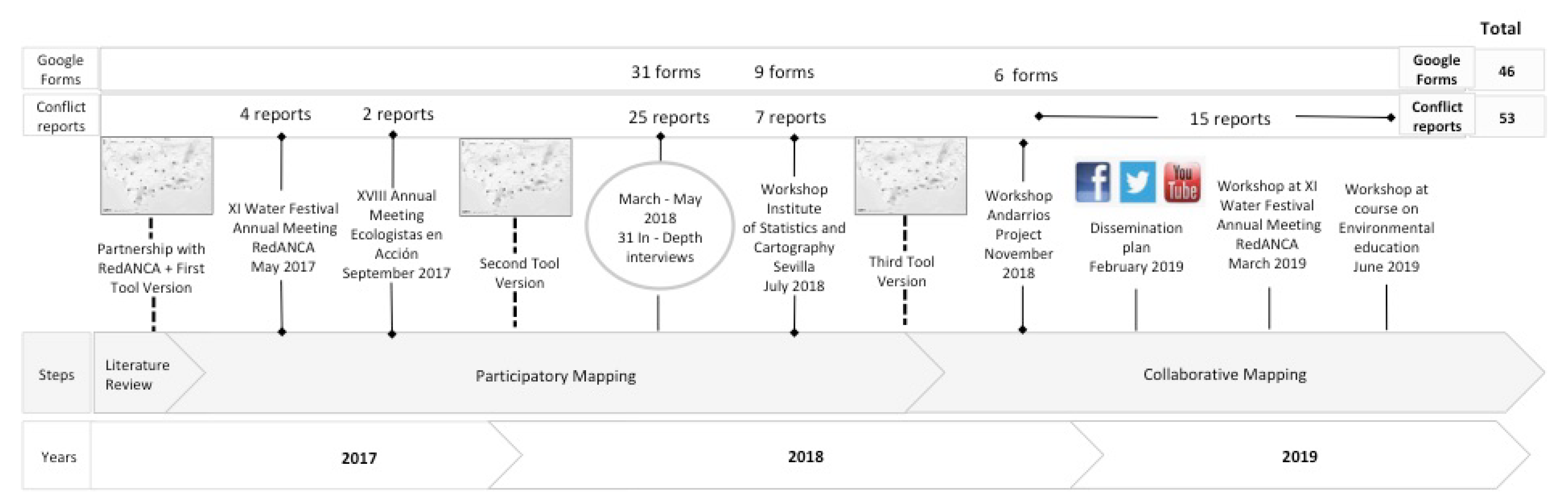
2. Materials and Methods
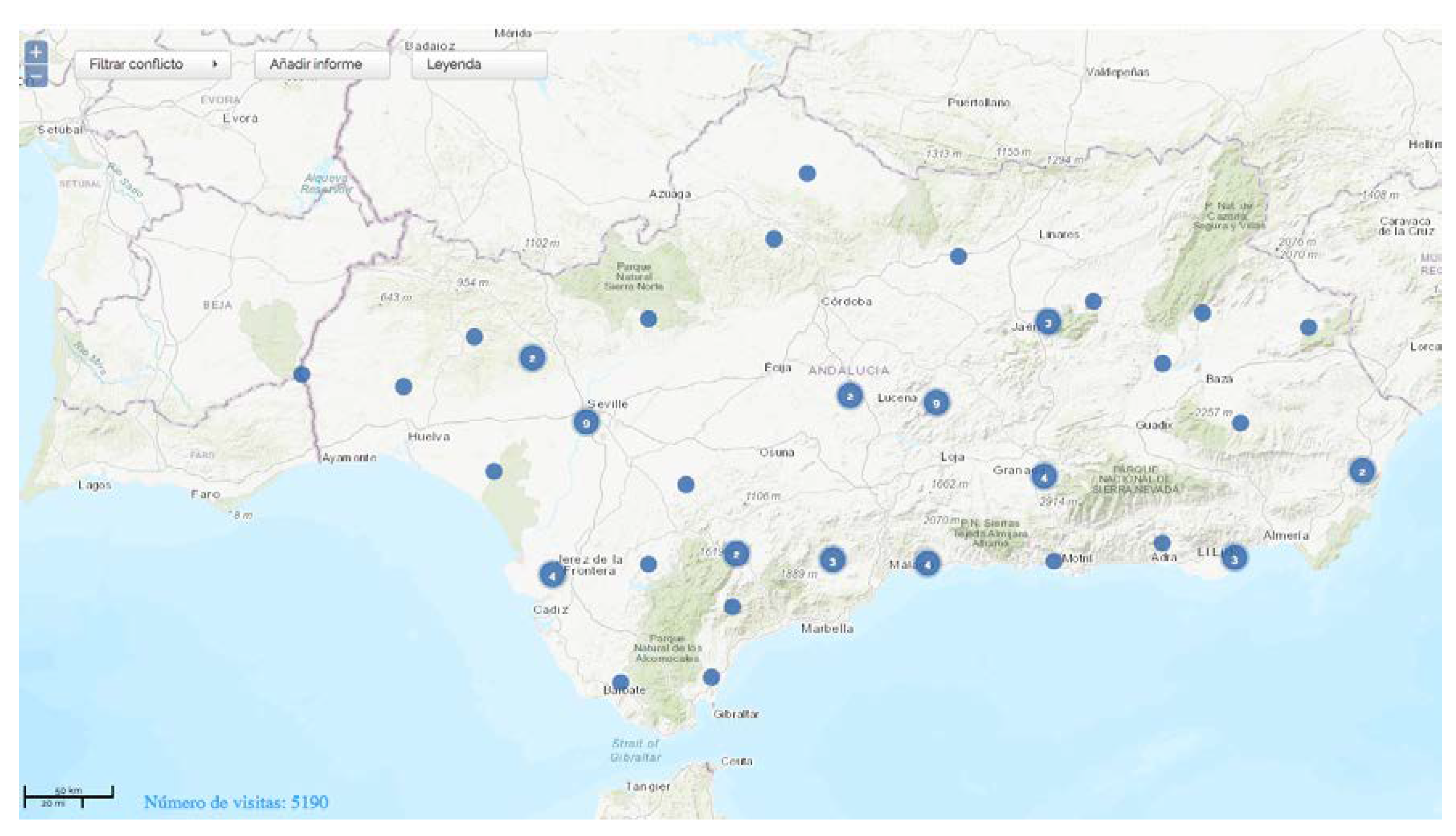
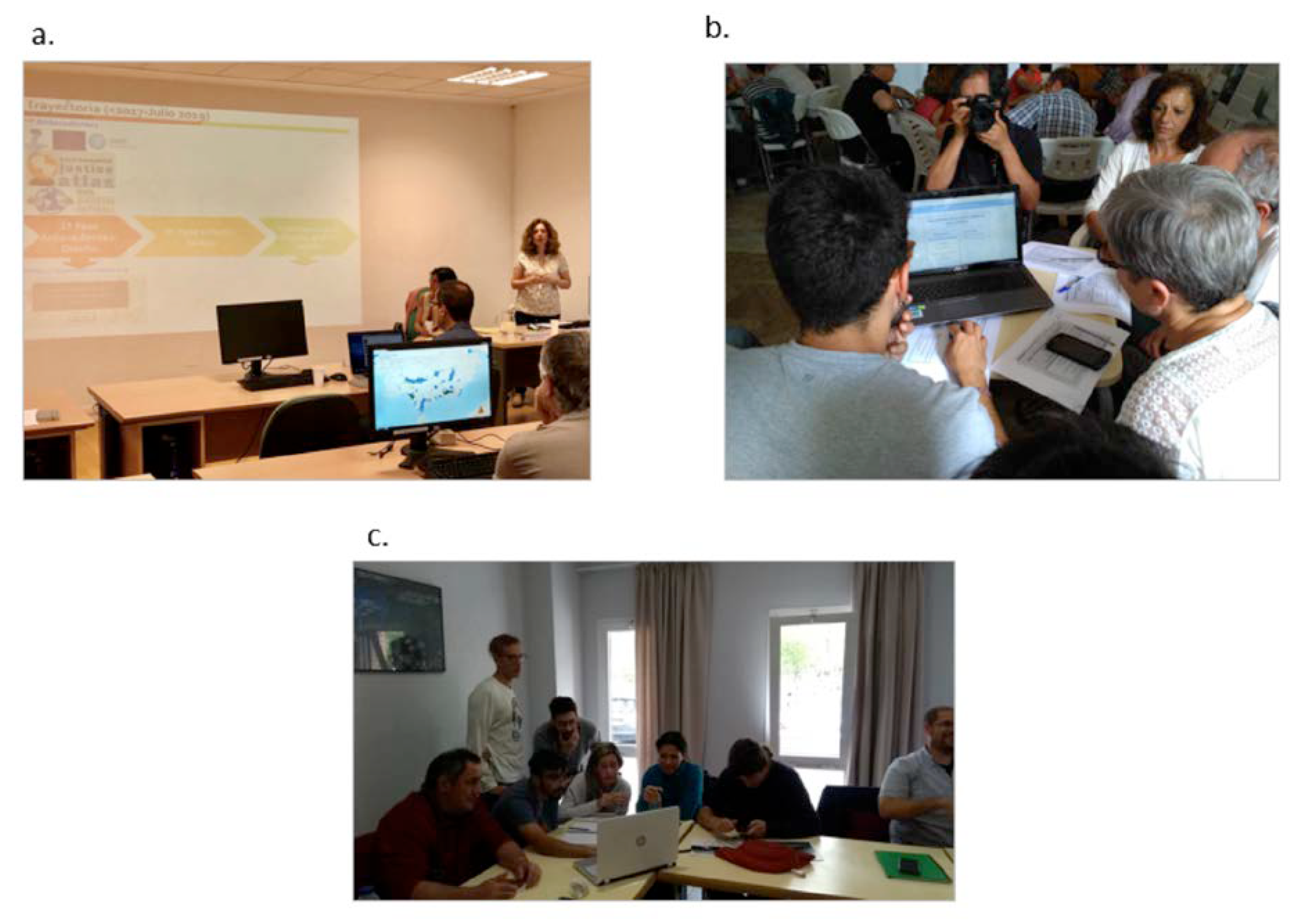
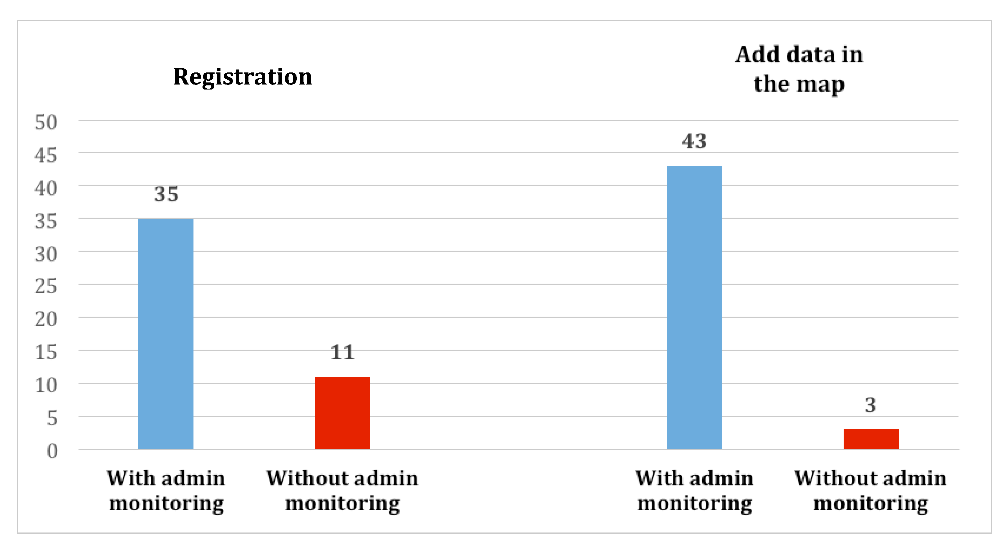
All citizen science or collaborative map production projects are faced with the instrumental objective of designing a tool capable of enabling citizens to independently include information. This goal requires a special dual effort in tool design: First, from the technological point-of-view, to make it easy for non-expert users to operate the tool unaided. Secondly, from an ontological and semantic point-of-view, to unequivocally determine the information that needs to be included and the terms in which this should be done through the construction of a common language (technical, expert, colloquial).
Both needs and challenges were tackled simultaneously from the project outset. The first phases of the construction of the map viewer were devoted to analyzing precedents, with special attention given to co-production and information management (the need to register or not to add new information) and publication (free publication vs. monitored publication). At the same time, the various software options and their functionalities and features were analyzed. Mindful of the time constraints and the available budget, and given the goal of fostering the open nature of the project during all of its phases, the Ushahidi free software tool was selected as it is expressly designed for social activism. The Ushahidi open-source platform is designed to facilitate information collection, visualization, and interactive mapping, while allowing the public to submit information through different channels, such as web forms, short message service (SMS), and email [42,43]. In this particular case, we chose to customize a web form to gather information reported by the activists themselves on the water conflicts in the Andalusia region.
Meanwhile, the map contents were defined: what should be mapped and what associated information would be of interest. These tasks were developed through the following steps and methods: (i) literature review—background check; (ii) team discussion and draft proposal; (iii) in-depth interviews, and (iv) integrated participative and collaborative mapping approach. Figure 2 synthesizes the general workflow of the integrated mapping process, along with the evolution of the number of conflict reports added, and Google forms gathered during the project’s two-year duration.
(i) Literature review—background check
The first phase was a background check: on the one hand, collaborative mapping projects were reviewed. The interface design and the report database structure of the Environmental Justice Atlas (ejatlas.org) and the “Map Barcelona + sustainable (http://www.bcnsostenible.cat/es/) management and participation model were of particular interest. This latter allows access to citizen reports in two different ways: through the webmap, by clicking on the location, and through the reports themselves, by clicking on the picture or report title listed on a specific report list webpage. At the same time, the terms used in the map were defined and categorized, based to a large extent on water planning technical documents: The European Union (EU) Water Framework Directive (2000)—WFD—and its Spanish developments—Instrucción de Planificación Hidrológica (ORDEN ARM/2656/2008)—hereafter IPH.
(ii) Team member discussion and draft proposal
A discussion was held by the team members, who included researchers from different backgrounds and disciplines: Anthropology, Human Geography, Political Science, Environmental Science, and Computer Science. This led to the first proposal for a hybrid design that combined the two above-mentioned precedents to document the water conflicts and the first version of the map viewer interface and management model: free registration and monitored publication. From that point on, map co-production was set in motion through two main actions:
(iii) Interviews with academics and/or activists
To be precise, 31 in-depth interviews were given to activists (Appendix A) selected using the snowball method with the Andalusian Network New Water Culture contacts—hereafter, indicated by its Spanish acronym Red-ANCA—as the starting point. This is a nonprobability sampling method applied when it is difficult to access subjects with the target characteristics. In this case, interviewees are asked to point out future subjects among their acquaintances. During this phase, we sought to contact informants from all the Andalusian provinces so that the map could document water conflicts throughout the entire region. The relatively high average age (55 years) of the interviewees must be highlighted, as must the large male bias of environmental activism in the region: 94% of interviewees were male. Regarding the collectives that they represented, 61% perform their role on the local scale, and the remaining 39% on the national scale (see Appendix A).
The duration of the interviews was 60–90 minutes and these were structured into two parts: (i) first participants were asked to test the web-design tool through map consultation and to add a full report of the water conflict with which they were involved. During this part of the interview, a member of the research group acted as a facilitator while taking observation notes on difficulties (technical, semantic) that arose during the session. (ii) During the second part of the interview, more extensive opinions, requests, and suggestions were gathered from the interviewees using a semi-structured questionnaire in Google-form format. A selection of these results is given in the following section. Informed consent was obtained from all the participants in data collection. Of the current 53 reports included in the map, 25 are from this phase.
(iv) Integrated participatory and collaborative mapping approach
Three participative mapping workshops were held during the project’s two-year duration to test the tool, and co-design its content and interface, plus a further three collaborative mapping workshops to disseminate the project and promote consultation and the contribution of information to the already-consolidated tool (Appendix B). In this sense, during the project’s lifetime, we applied an integrated participatory-collaborative mapping approach [3].
Most of the workshops were held in the context of annual assemblies called by citizen movements (environmentalists, supporters of territorial heritage, and human right to water activists) or in the framework of environmental education promoted by the regional administration. Only one was specifically organized by the work team, in collaboration with the Institute of Statistics and Cartography of Andalusia, so as to include the views of other people with more technical and administrative profiles in the tool’s co-design (see Appendix B).
All the workshops were structured into three activities: first, an introduction to the project, and the workshop’s purpose and structure, by a member of the research group (Figure 3a). Second, participant interaction with the tool organized as follows: each member of the organizing team coordinated a group of approximately 3–4 participants (out of a total of 20–30 participants, depending on each particular case). In these sessions, participants were asked to consult the designed web platform, unaided, and for several people in the same group to upload a new water conflict report. Meanwhile, the coordinator acted as an observer/facilitator in the session, taking observation notes on the difficulties and suggestions that arose (Figure 3b). Third, at the end of the session, group impressions and suggestions were collected on the same form used for the in-depth interviews (Figure 3c). Fifteen forms from these sessions were added to the previously mentioned 31. It should be noted that responses were not given to all of the questions on some of these, with results ranging from 44 to 46 responses, depending on the case.
The water conflict reports located in the current web-map that come from these workshops are indicated in Appendix B: 13 new water conflict reports from participatory mapping workshops and 15 from the collaborative mapping and dissemination phase. It should be noted that the tool enables registered users to edit their reports at a later date, to either add new information or modify existing information, and this occurred in 8 cases.
Once the cartographic viewer design process and the database structure of the customized web form used to gather information had been concluded, the last phase of the project was devoted to numerous dissemination campaigns with a dual objective: on the one hand, to foment autonomous submissions to the webmap and, on the other, to promote social awareness of the water conflicts already represented on the map. During this phase of the project, 15 new reports were added to the map from voluntary contributions made by activists.

3. Results

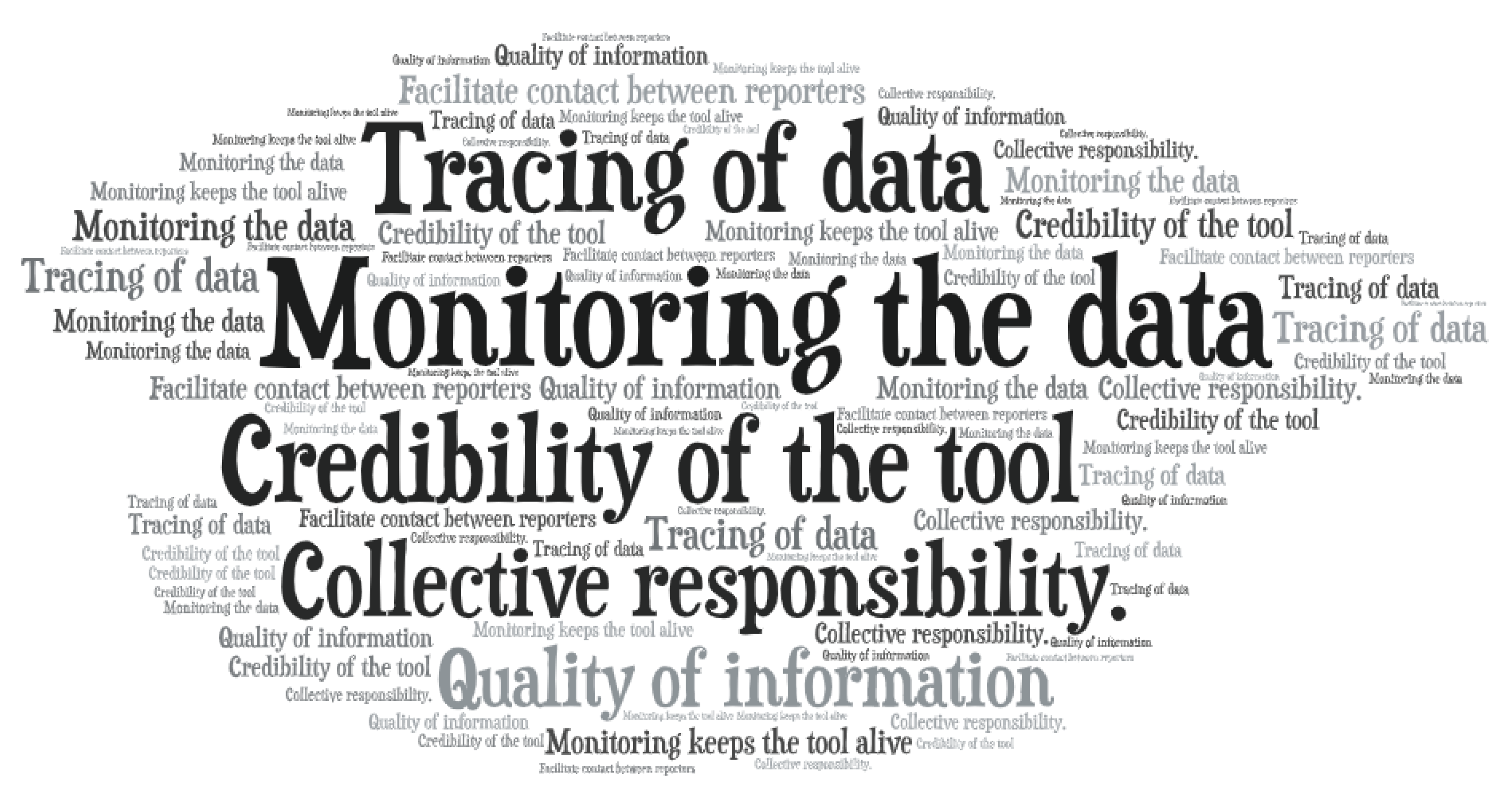
3.1. Ontological and Semantic Challenges: Building a Common Language

The participative mapping workshops and the interviews immediately highlighted that the greatest difficulty facing us when designing the tool was conceptual and linguistic, beginning with the concept of the map itself: What did we consider a water-related “conflict” and/or “initiative” to be? How could these be categorized to show all the conflicts and social initiatives that the interviewees were acquainted with? How could formal public policy planning requirements be reconciled with activists’ needs and language? How could conflict categories be defined that made sense to activists and public officials in the context of the WFD implementation process?
Therefore, from the very outset, the need existed to assume a teaching role while the definitions and categories proposed by the research team were questioned in an iterative co-production and collective learning process. To help solve this problem, a range of teaching materials was prepared on the (re)definition of the project and its theoretical framework and the main concepts being handled. These materials were shared in both text format and video, with both accessible on the map website.
Establishing the conflict source typologies was especially complicated with numerous modifications and suggestions for improvement throughout the customized web form co-design stage. This highlighted the negotiation-reaction and knowledge co-production process referred to earlier. This is, perhaps, the most representative case of the need to reconcile technical-scientific and colloquial language, the techno-social utility of compiled information, and its socio-political utility and the project’s “instrumental” and “empowering” perspectives [23].
During the tool’s test phase, suggestions were received for modifications with clear references made to the complex structure of the report database. The initial conflict source categorization, which applied in detail the categories in the Water Planning Technical Instruction Manual to identify the pressures and impact analysis on water bodies, caused a certain amount of confusion among workshop participants, who suggested that the categories should be simplified, as can be seen in this example for the “pollution” category (Table 1). Similarly, the difficulty of identifying a single conflict source led participants to suggest that categories should not be mutually exclusive.
In this context of balance, the solution arrived at was a hybrid typology that integrated the typology of pressures on water bodies established by the WFD in the way that they are specified and developed by the IPH in the Spanish regulatory framework. This has also been extended to other categories (of a cultural and social type) that have emerged from the team’s experience, and the contributions made during the interviews and workshops (see Appendix C).
Indeed, there is no room in the WFD’s express conceptual framework for some social demands, such as support for water heritage and landscapes, the guarantee of the human right to water, and the defense of non-economic water use, whether recreational or cultural. For this reason, two other conflict source categories were added to the map: the importance of citizen participation in processes to defend the public management of urban water services, and their remunicipalization in cases where they have been privatized (Appendix C, category 5: Problems with urban water supply and sanitation services); and the presence of cultural water heritage and water landscapes, which are at the heart of the social understanding of nature and, more specifically, aquatic ecosystems (Appendix C, category 6. Effects on social heritage). A database structure emerged from this hybridization of perspectives that was complex, ambitious, and required the attention and effort of the cooperating collectives. However, at the same time, it was unquestionably rich and showed considerable potential for the contribution of precise, processable information with different tools that not only empower the collectives themselves, but in good time may produce useful information for management and planning by administrations.
Thanks to this redefining of the initial proposals, even though this terminology is not habitually used by activist groups—especially the terms derived from the WFD conceptual framework—it appears that there has been a high level of understanding and, in general terms, no difficulties have been detected for the conflicts to be conceptualized in the framework finally proposed in the project. In this sense, 91% (n 44) of informants stated that they intuitively understood the vocabulary used in the tool, while 78% (n 46) responded that it was very easy (39%, n 46) or quite easy (39%, n 46) to supply information in the customized web form.
We were thus able to corroborate that the construction process implemented in this project resulted in a collective conceptual debate and the co-production of data-information-knowledge useful for co-creating social agents and simultaneously specific, categorizable, and precise for guiding management. The singularity of this approach is the fundamental innovation in this experience.

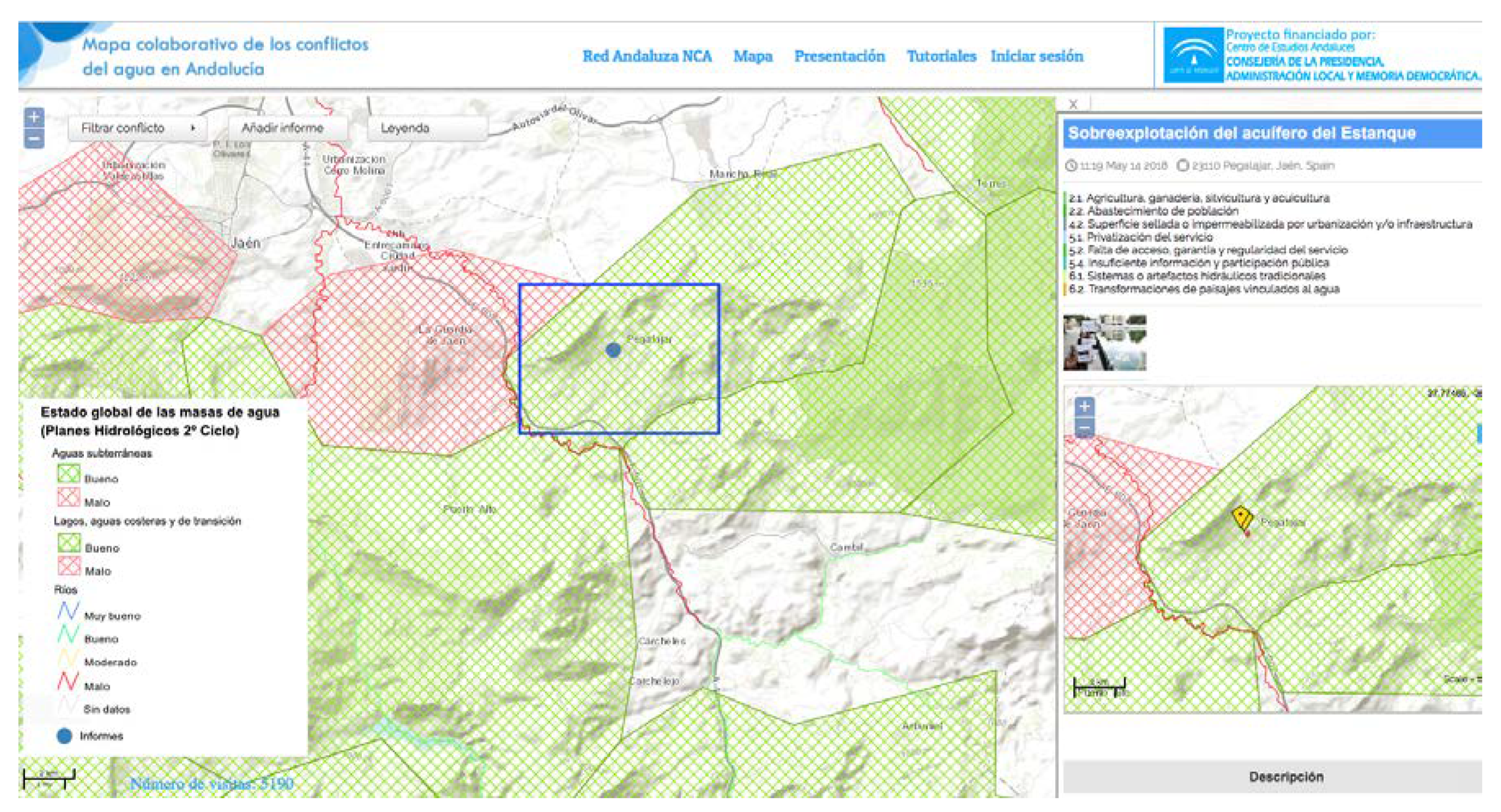
3.2. Technological Challenges: Map Final Design and Management

From the outset, one of the main concerns around the project was guaranteeing sustainability during the map’s natural life: How could the map be kept updated once the project had concluded? How could public participation be sustained? This is the reason why it was essential to form alliances with associative networks and citizen platforms to make advances in the difficult task of participation and the implementation of citizen science throughout its creation process.
This strategy is another of the experience’s major unique features: that embarking on a research project leads to becoming entwined in the processes of pre-existing organizations and social movements and aspiring to be sustained over time by autonomous social energies.
The Map-RedNCA interleaves a research project with the organizational and communication structure of the Andalusian Network of the New Water Culture, an organization that has been operating in the region since 2004. One aspect of the way that this hybridization to which knowledge co-production experiences have so aspired has been realized, is that the map has been included on the Red-ANCA website, with the project, in turn, contributing content and development. This integration, which is one of the project’s main novelties and potentialities, boosts the possibility of becoming woven into the social fabric and for the map to be sustainable over time, two of the greatest difficulties for projects of this type. This is the very reason why mapping workshops were included at events organized by these associations in annual assembly formats and/or environmental education courses.
It was, precisely, during the workshop phase and, subsequently, during the autonomous contribution phase, that we observed that less important conflicts on the regional scale were being included by local collectives that were more outspoken in their demands. This sparked another debate during the initial stages of the project’s development: the scale and importance of the water conflict, its own physical-environmental-social entity, which requires coherent inclusion or exclusion criteria to be established. Casuistry and debate were triggered around the collective-social dimension of conflicts, the point or level at which the limits were to be set for their inclusion on the regional scale to be considered. Who determines the relevance of a conflict? Is it the editing team or the user community that sets the threshold?
In relation to this debate, and in the same framework of dynamic interweaving between researchers and activists, a wider discussion was posited around management models: Should the map be moderated by experts or should registration be open? Should the user community act as moderators? Which model would lead to greater sustainability over time and maintain information quality?
Our analysis of earlier collaborative mapping projects showed four management options: (i) free registration, where the user does not need the approval of the system administrator to upload information; (ii) monitored registration, where the user requires the approval of the system administrator to upload information; (iii) free publication, where uploaded information does not need the approval of the system administrator to be published; (iv) monitored publication, where uploaded information needs the approval of the system administrator to be published [22].
Although the team’s original intention was to create a completely unmonitored, freestanding tool that could be integrated into and support the action of the social organization involved, the background check and the opinions collected during the interviews and in the workshops led us to change our opinion. In short, the majority of the interviewees thought that both registration to allow information to be added to the map (76% n 46) and the creation and publication of reports (93% n 46) should be monitored (Figure 4). When we inquired about the advantages of monitoring, most agreed that it was the most appropriate model for guaranteeing the quality of the added information and, consequently, its credibility (Figure 5).
Concerning the technical operation of the tool, the observed results show that there have been no significant issues apart from some people whose general use of technology is limited, which, therefore, negatively affects their contribution to the project. In contrast, the ease with which digital natives interacted with the tool and its applications (consultations, filtering of reports, editing points on the map, etc.) is worthy of mention. However, this participant sector showed a preference for formats linked to cellphone application and social network-based information and communication technologies. This led us to consider that the tool’s foreseen self-sustaining continuity over time advised a more in-depth examination of this aspect to design a tool that people—especially young people—can use daily.
Throughout the web-tool co-design process, we identified the need to include more instructions than were initially envisaged, to modify some of the sections in the report database to make it easier to understand the language used in the viewer, and to incorporate the activists’ demands, including the identification of peri-urban spaces, as especially high-tension areas and the target of their demands, and the incorporation of forms of mobilization not initially envisaged, such as collecting signatures and drafting allegations.
As a result, the map shows the exact locations of conflicts with links to fact files containing descriptions of the conflicts given by the actors involved in line with the information categories given in Table 2. These include the reasons for the mobilizations, aspects related to access to information and participation in institutional processes, the social agents involved, and the dynamics and outcome of the conflict.
Given the dual objective of integrating the “empowerment” and “instrumental” perspectives, these data were added to the webmap as a point layer and overlaid with physical and other GIS data layers—such as the global status of water bodies according to the public administration—to examine spatial relationships between activists’ perceptions and the physical attributes of place, according to the competent administration.
Thus, the map enables the observation of the contradictions between local perceptions, generally well-founded in reality, and the water planning diagnosis, which the map provides, of the same water bodies. One example that illustrates this is the overexploitation of the Estanque aquifer (Pegalajar, Jaén province) (Figure 6), which in official River Basin Plan cartography is given a classification of “good overall state of water bodies”.
In the same sense, 17 cases have been identified in which poor river and aquifer quality has been denounced in places where the data provided by the water Administration (Global status of water bodies included in River Basin Plans, second cycle 2015-2021) state the opposite.

4. Discussion and Conclusions

The regulatory and institutional framework, especially in the area of environmental policy, requires the complexity, the deep uncertainties, and the vested interests at stake in decision processes to be addressed with the participation of all the legitimate social agents involved, and supported with the due information, and the fullest and most rigorous knowledge possible of the factors involved in the issues. In the case of water policy, the regulations involved, the WFD, lay down specific protocols and methodologies that seek to operationalize this strategy through the focuses of information, consultation, and the active participation in water basin planning processes of stakeholders and the public in general. However, despite this sound institutional framework, as anticipated by the author of the seminal paper “A ladder of citizen participation” [44] (p. 216), “there is a critical difference between going through the empty ritual of participation and having the real power needed to affect the outcome of the process.”
This article has presented synthetically the theoretical framework on which the collective knowledge co-production strategy is founded and the specific methodology used by the Map of Water Conflicts in Andalusia, essentially based on an integrated participatory and collaborative mapping approach. The process to construct the Webmap-RedNCA combines the two approaches that Liu et al. [3] suggest: (a) participatory—through face-to-face workshops and in-depth interviews that contribute to the co-design and co-creation of the tool, and (b) collaborative—through the promotion of volunteered contributions to the final webmap via face-to-face workshops, but mostly by social media campaigns. These two approaches have meant that activists have been involved from the very beginning of the mapping process and engaged throughout the two-year project.
In addition, in our case, the contribution made by the web platform does not occur as a creation exogenous to a social movement, but is integrated into its organizational structure, and updates and improves the movement’s website. Its acceptance and recognition are thus increased by the collective, as is its operability and the possibilities that it will be sustained over time and beyond the administrative life of the scientific-academic project, which is also a fundamental part of the process. The consequences of this merging have already been seen in the form of the experience’s dissemination in various critical-alternative media with a significant social impact. These include the magazines El Salto and El Ecologista, published in the Spanish capital, Madrid, which have included reports on the Map-RedNCA in their April 2019 and winter 2019–2020 editions, respectively. The non-governmental organization ONGAWA also includes this project as an outstanding experience of social initiatives adapted to climate change. Various scientific projects that are part of ResCities, coordinated by the Open University of Catalonia, and the University of Huelva, have also associated themselves with the experience.
For their part, Lepenies et al. [22] state that the political nature of co-production must be explicitly accepted, by which its different possible perspectives should be understood: co-production in a public services perspective and co-production in a sustainability sciences perspective, each of which comes with different traditions and variants, and different political implications in water governance that could be called instrumental and empowering, respectively [22]. Our challenge, in this regard, has been to co-create a collaborative map tool with the ability to combine the two perspectives: the experience of a co-production process of data-information-knowledge that is both useful for the co-creating social actors—environmental activists—and also sufficiently specific, categorizable, and precise to guide the water management of the competent administrations: a repository of activist knowledge that could also be useful for the public administration.
The outcome of this process is a webmap that organizes a certain type of previously unviewable information. In the same line as the previous experiences that inspired it, the Map-RedNCA provides empirical material for a research agenda aimed at understanding how transformations are produced and understood in socio-ecological systems, where there is an unequal distribution of good and bad between different social sectors, a research agenda designed to understand how, where, and with what results those affected fight against these effects.
The degree to which the tool’s continuity, extension, and consolidation in the social fabric might help to produce some tangible results in the future remains to be seen. The co-production approach in environmental policies has the potential for building better water ecosystems, but its effective implementation requires institutional transformations to overcome resistance to power redistribution in terms of inclusivity and equity.
The Map of Water Conflicts in Andalusia experience is positioned as a new methodological precedent and a starting point for similar new projects. As noted by Brown and Kyttä [45] (p.122), the modern geospatial revolution, with technologies that map earth systems, has greatly accelerated understanding of the physical world. However, the knowledge of social and cultural landscapes is more complex, with understanding proceeding at a much slower pace. We believe this map represents a contribution to this field.
At this time, the Map-RedNCA faces the challenge of becoming fully self-sustaining and taking on a life of its own and, consequently, becoming an interesting opportunity to extend the theory and practice of mapping environmental justice and the geographic discipline committed to this.

Author Contributions

All the authors contributed to the conception of this article and the writing of the manuscript. Cesare Laconi conducted the interviews and compiled the statistics. All authors have read and agreed to the published version of the manuscript.

Funding

This research was funded by FUNDACIÓN CENTRO DE ESTUDIOS ANDALUCES under the “Atlas digital colaborativo de la justicia ambiental en el agua. Contribución a la transparencia y los datos abiertos en las políticas públicas de Andalucía” (PRY125/17) project.

Acknowledgments

We would like to express our gratitude to all those who agreed to be interviewed for this research and to all the contributors involved in the mapping workshops. We would also like to thank Antonio Figueroa, Gabriel Orozco, Maria Mancilla, Violeta Cabello, and Juan Romero for their contributions and support, particularly in the early phases of research. We are deeply grateful to Maria Mancilla for her insightful and valuable comments, which have greatly improved this article.

Conflicts of Interest

The authors declare no conflict of interest. The funders played no role in the design of the study, in data collection, analysis, or interpretation, in the writing of the manuscript or in the decision to publish the results.

Appendix A

In-depth interviews by province of water conflict locations, interviewees’ age and gender, and organizations (March–May 2018).
Number of Interviewees by ProvinceNumber of Interviewees by Age Group and GenderOrganizations
(n)Age groups(n)ACPES—Asociación para la conservación piscícola y de los ecosistemas acuáticos del sur.
Acuíferos Vivos
ADTA—Asociación en Defensa del Territorio del Aljarafe
Amigos de la Janda
AMECO—Asociación Medioambiental para la conservación de plantas y animales
Asociación Fuente la Reja
Asociación Río Bejarano
Ecologistas en Acción
El Bosque Animado
Grupo Ecologista Vera
Marea Azul Granada
Plataforma de Defensa del Río Castril
Plataforma de Defensa Río Eliche
Plataforma NCA Jódar
Plataforma Rio Aguas
Priego Agua y Desarrollo
Promar
Rizoma
WWF
Local: 61%
National: 39%
Almería321–30 years1
Cádiz531–40 years6
Córdoba241–50 years7
Granada251–60 years10
Huelva261–70 years7
Jaén5Total31
Málaga5
Sevilla7Mean Age55
Total31Gender(%)
Male94%
Female6%

Appendix B

Chronology of mapping workshops by location, context, type, and number of Google forms gathered and final reports added to the webmap.
DateLocation (Province)EventOrganizerWorkshop Type and Number of Reports
05/26-28/2017Castril (Granada)XI Water Festival—Red-ANCA
annual meeting
Environmental Group: Andalusian Network New Water Culture—Red-ANCAParticipative
Mapping

Semi-structured interviews (Google forms): 9

Water conflict reports: 13
09/23/2017El Bosque (Cádiz)XVIII Ecologistas en Acción—Andalucía Annual meetingEnvironmental Group: Ecologistas en Acción-Andalusia
07/02/2018Sevilla (Sevilla)Workshop on contributions to map of water conflicts in AndalusiaResearch Group and Institute of Statistics and Cartography of Andalusia
11/17/2018Málaga (Málaga)Workshop on participation and management of river ecosystems in the Guadalquivir river basin district—
Andarríos Project
Regional Administration—
Andalusian Department of the Environment and Land Planning
Collaborative mapping + Dissemination Plan

Semi-structured interviews (Google forms): 6

Water conflict reports: 15
01/22/2019Priego de Córdoba (Córdoba)XII Water Festival Red-ANCA
Annual meeting
Environmental Group: Andalusian Network New Water Culture—Red-ANCA
06/01/2019El Bosque (Cádiz)Course on environmental education and ecological transitionRegional Administration—Andalusian Plan for environmental education

Appendix C

Conflict source categories and number of water conflict reports in broad categories.
TypeSubtypeTheoretical FrameworkNo.
Reports
1. Pollution 1.1. Waste (urban, industrial, ranch, desalinization)
1.2. Landfill and waste disposal facilities
1.3. Diffuse source (agricultural, ranch, urban, transport, mines, polluted land, etc.)
WFD23
2. Significant water extraction 2.1. Agriculture, ranching, forestry, and aquaculture
2.2. Public supply
2.3. Electricity production
2.4. Other industrial uses
2.5. Quarries and mining activities
WFD25
3. Regulation work and morphological changes 3.1. Reservoirs
3.2. Water transfer and diversions
3.3. Alterations: crosswise (weirs, dams, bridges)
3.4. Alterations: lengthwise (channeling, cladding, dredging, etc.)
3.5. Coastal works (ports, breakwaters, etc.)
WFD22
4. Land use (effects on basin and banks)4.1. Surface affected by degradation process (fire, deforestation, etc.)
4.2. Surface sealed by urbanization and/or infrastructure
4.3. Degradation of river corridor: deterioration of riverside woodland, aggregates extraction
WFD23
5. Issues with supply and urban sanitation services 5.1. Service privatization
5.2. Lack of access to services or guaranteed and regular service
5.3. Charges and tariffs
5.4. Insufficient information and public participation
Public Participation19
6. Effects on cultural heritage 6.1. Traditional hydraulic systems or artifacts
6.2. Transformation of water-related landscapes
Cultural Heritage20
7. Other anthropogenic
events
7.1. Introduction of non-native species
7.2. Artificial injections into the sub-soil
(gas reserves, fracking)
7.3. Other (recreational activities, land drainage)
WFD19

References

  1. Brown, G.; Kyttä, M. Key Issues and Priorities in Participatory Mapping: Toward Integration or Increased Specialization? Appl. Geogr. 2018, 95, 1–8. [Google Scholar] [CrossRef]
  2. Goodchild, M.F. Citizens as sensors: The World of Volunteered Geography. GeoJournal 2007, 69, 211–221. [Google Scholar] [CrossRef] [Green Version]
  3. Liu, W.; Dugar, S.; McCallum, I.; Thapa, G.; See, L.; Khadka, P.; Budhathoki, N.; Brown, S.; Mechler, R.; Fritz, S.; et al. Integrated Participatory and Collaborative Risk Mapping for Enhancing Disaster Resilience. ISPRS Int. J. Geo-Inf. 2018, 7, 68. [Google Scholar] [CrossRef] [Green Version]
  4. Connors, J.P.; Lei, S.; Maggi, K. Citizen Science in the Age of Neogeography: Utilizing Volunteered Geographic Information for Environmental Monitoring. Ann. Assoc. Am. Geogr. 2012, 102, 1267–1289. [Google Scholar] [CrossRef]
  5. Funtowicz, S.O.; Ravetz, J.R. Science for the Post-Normal Age. Futures 1993, 25, 735–755. [Google Scholar] [CrossRef]
  6. Funtowicz, S.O.; Ravetz, J.R. The Worth of a Songbird: Ecological Economics as a Post-Normal Science. Ecol. Econ. 1994, 10, 198–207. [Google Scholar] [CrossRef] [Green Version]
  7. Corbett, J. Good Practices in Participatory Mapping: A Review Prepared For The International Fund for Agricultural Development (IFAD); International Fund for Agricultural Development: Roma, Italy, 2009; pp. 1–55. [Google Scholar]
  8. Peluso, N.L. Whose Woods Are These? Counter-Mapping Forest Territories in Kalimantan, Indonesia. Antipode 1995, 27, 383–406. [Google Scholar] [CrossRef]
  9. Sieber, R. Public Participation Geographic Information Systems: A Literature Review and Framework. Ann. Assoc. Am. Geogr. 2006, 96, 491–507. [Google Scholar] [CrossRef]
  10. Risler, J.; Ares, P. Talleres de Mapeo. Recursos Lúdicos y Visuales para la Construcción de Conocimiento Colectivo. Ecol. Política 2014, 48, 28–32. [Google Scholar]
  11. Ortega, D. Atlas de la Anticoperación Española en los Países del sur; Observatorio de la Deuda en la Globalización (ODG): Barcelona, Spain, 2011; pp. 1–43. Available online: https://odg.cat/wp-content/uploads/2014/06/atlas_anticooperacion.pdf (accessed on 20 January 2020).
  12. Corbett, J.; Cochrane, L.; Gill, M. Powering Up: Revisiting Participatory GIS and Empowerment. Cartogr. J. 2016, 53, 335–340. [Google Scholar] [CrossRef]
  13. Gibson-Graham, J.K. Diverse Economies: Performative Practices for ‘Other Worlds’. Prog. Hum. Geog. 2008, 32, 613–632. [Google Scholar] [CrossRef]
  14. Temper, L.; Del Bene, D.; Martinez-Alier, J. Mapping the Frontiers and Front Lines of Global Environmental Justice: The EJAtlas. J. Political Ecol. 2015, 22, 255–278. [Google Scholar] [CrossRef] [Green Version]
  15. Vélez, I.; Rátiva, S.; Varela, D. Cartografía Social como Metodología Participativa y Colaborativa de Investigación en el Territorio Afrodescendiente de la Cuenca Alta Del Río Cauca. Cuad. Geogr. Rev. Colomb. Geogr. 2012, 21, 59–73. [Google Scholar] [CrossRef] [Green Version]
  16. Bittner, C.; Glasze, G.; Turk, C. Tracing contingencies: Analyzing the political in assemblages of web 2.0 cartographies. GeoJournal 2013, 6, 935–948. [Google Scholar] [CrossRef]
  17. Bacon, C.; deVuono-Powell, S.; Frampton, M.L.; LoPresti, T.; Pannu, C. Introduction to Empowered Partnerships: Community-Based Participatory Action Research for Environmental Justice. Environ. Justice 2013, 6, 1–8. [Google Scholar] [CrossRef]
  18. Bosque-Sendra, J. Neogeografia, Big Data y TIG: Problemas y Nuevas Posibilidades. Polígonos. Revista de Geografía 2015, 272, 165–173. [Google Scholar] [CrossRef] [Green Version]
  19. Cerda-Seguel, D. Mapas Digitales y Sociedad: Geosemántica Social, el Poder del Sentido de Lugar. Polígonos. Revista de Geografía 2015, 27, 61–96. [Google Scholar] [CrossRef]
  20. Temper, L.; Del Bene, D. Transforming Knowledge Creation for Environmental and Epistemic Justice. Curr. Opin. Environ. Sustain. 2016, 20, 41–49. [Google Scholar] [CrossRef]
  21. Membrado-Tena, J.C. La Geografía Académica frente a la Neogeografía, in Naturaleza, Territorio y Ciudad en un Mundo Global, In Proceedings of the XXV Congreso de la AGE, Madrid, Spain, 25–27 October 2017.
  22. Laconi, C.; Pedregal, B.; Del Moral, L. La Cartografía Colaborativa para un Cambio Social. Análisis de Experiencias. In Perspectivas Multidiciplinares en la Sociedad del Conocimiento; López-García, M.J., Carmona, P., Salom, J., Albertos, J.M., Eds.; Universitat de València: Valencia, Spain, 2018; pp. 821–830. [Google Scholar]
  23. Lepenies, R.; Hüesker, F.; Beck, S.; Brugnach, M. Discovering the Political Implications of Coproduction in Water Governance. Water 2018, 10, 1475. [Google Scholar] [CrossRef] [Green Version]
  24. Funtowicz, S.O.; Ravetz, J.R. La Ciencia Posnormal: Ciencia con la Gente; Icaria Editorial: Barcelona, Spain, 2000. [Google Scholar]
  25. Xiang, W. Working with Wicked Problems in Socio-Ecological Systems: Awareness, Acceptance, and Adaptation. Landsc. Urban. Plan. 2013, 110, 1–4. [Google Scholar] [CrossRef]
  26. Euler, J.; Heldt, S. From Information to Participation and Self-Organization: Visions for European River Basin Management. Sci. Total Environ. 2018, 621, 905–914. [Google Scholar] [CrossRef] [PubMed]
  27. OCDE. Stakeholder Engagement for Inclusive Water Governance; Organisation for Economic Co-operation and Development Studies on Water; OECD Publishing: Paris, France, 2015. [Google Scholar]
  28. Antunes, P.; Kallis, G.; Videira, N.; Santos, R. Participation and Evaluation for Sustainable River Basin Governance. Ecol. Econ. 2009, 68, 931–939. [Google Scholar] [CrossRef]
  29. Kallis, G.; Videira, N.; Antunes, P.; Guimaraes-Pereira, A.; Spash, C.; Coccossis, H.; Corral, S.; Del Moral, L.; Hatzilakou, D.; Lobo, G.; et al. Participatory Methods for Water Resources Planning. Environ. Plan. C Politics Space 2006, 24, 215–234. [Google Scholar] [CrossRef]
  30. Mancilla, M.; Bodin, Ö. Participatory Water Basin Councils in Peru and Brazil: Expert Discourses as Means and Barriers to Inclusion. Glob. Environ. Change 2019, 55, 139–148. [Google Scholar] [CrossRef]
  31. Brown, G.; Chin, S.Y.W. Assessing the Effectiveness of Public Participation in Neighbourhood Planning. Plan. Pract. Res. 2013, 28, 563–588. [Google Scholar] [CrossRef]
  32. Ballester, A.; Mott, K.E. Public Participation in Water Planning in the Ebro River Basin (Spain) and Tucson Basin (U.S., Arizona): Impact on Water Policy and Adaptive Capacity Building. Water 2016, 8, 273. [Google Scholar] [CrossRef]
  33. Garmendia, E.; Stagl, S. Public Participation for Sustainability and Social Learning: Concepts and Lessons from Three Case Studies in Europe. Ecol. Econ. 2010, 69, 1712–1722. [Google Scholar] [CrossRef]
  34. Tippett, J.; Searle, B.; Pahl-Wostl, C.; Rees, Y. Social Learning in Public Participation in River Basin Management-Early Findings from HarmoniCOP European Case Studies. Environ. Sci. Policy 2005, 8, 287–299. [Google Scholar] [CrossRef]
  35. Monroe, M.; Plate, R.; Oxarart, A. Intermediate Collaborative Adaptive Management Strategies Build Stakeholder Capacity. Ecol. Soc. 2013, 18, 24. [Google Scholar] [CrossRef] [Green Version]
  36. Muro, M.; Jeffrey, P. Time to Talk? How the Structure of Dialog Processes Shapes Stakeholder Learning in Participatory Water Resources Management. Ecol. Soc. 2012, 17, 3. [Google Scholar] [CrossRef] [Green Version]
  37. Innes, J.E.; Booher, D.E. Reframing Public Participation: Strategies for the 21st Century. Plan. Theory Pract. 2004, 5, 419–436. [Google Scholar] [CrossRef]
  38. Verplanke, J.M.; McCall, K.; Uberhuaga, C.; Rambaldi, G.; Haklay, M. A Shared Perspective for PGIS and VGI. Cartogr. J. 2016, 53, 308–317. [Google Scholar] [CrossRef] [Green Version]
  39. Kaika, M. Don’t call me resilient again: The New Urban Agenda as Immunology… or… What Happens When Communities Refuse to Be Vaccinated With ‘Smart Cities’ and Indicators. Environ. Urb. 2018, 29, 89–102. [Google Scholar] [CrossRef] [Green Version]
  40. Directive 2000/60/EC of the European Parliament and of the Council of 23 October 2000 Establishing a Framework for Community Action in the Field of Water Policy. Off. J. Eur. Communities 2000, 22, 12.
  41. Temper, L.; Demaria, F.; Scheidel, A.; Del Bene, D.; Martinez-Alier, J. The Global Environmental Justice Atlas (EJAtlas): Ecological distribution conflicts as forces for sustainability. Sustain. Sci. 2018, 13, 573–584. [Google Scholar] [CrossRef] [Green Version]
  42. Okolloh, O. Ushahidi, or ‘Testimony’: Web 2.0 Tools For Crowdsourcing Crisis Information. Participatory Learn. Action 2009, 59, 65–70. [Google Scholar]
  43. Singh, H. Creation of a Crowdsource Web Application using OpenSource Ushahidi Platform. IJCST 2013, 4, 54–56. [Google Scholar]
  44. Arnstein, S.R. A Ladder of Citizen Participation. J. Am. Inst. Plan. 1969, 35, 216–224. [Google Scholar] [CrossRef] [Green Version]
  45. Brown, G.; Kyttä, M. Key Issues and Research Priorities for Public Participation GIS (PPGIS): A Synthesis Based on Empirical Research. Appl. Geogr. 2014, 46, 122–136. [Google Scholar] [CrossRef]
Figure 1. Interface of the participatory webmap of water conflicts in Andalusia (Spain). Note: a small dot indicates a conflict site. The larger dots identify the sites of two or more conflicts. These disaggregate when zooming in on the map and pinpoint the locations with greater precision. Source: Map-Red-Nueva Cultura del Agua (RedNCA), https://redandaluzaagua.org/mapa/ retrieved December 2019.
Ijgi 09 00130 g001
Figure 2. General workflow of the integrated mapping process.
Ijgi 09 00130 g002
Figure 3. Mapping workshop process. (a) Introduction to the Project; (b) testing the web-design tool through map consultation and by adding a water conflict report; (c) gathering opinions and suggestions using a semi-structured questionnaire in Google-form format.
Ijgi 09 00130 g003
Figure 4. Choose the management options from the following that you believe are most appropriate. Prepared by authors using unpublished data taken from Google-Form survey forms.
Ijgi 09 00130 g004
Figure 5. What advantage do you see to monitoring by an administrator? (Open answers). Prepared by authors using unpublished data taken from Google-Form survey forms. Note: Word size is proportional to the frequency.
Ijgi 09 00130 g005
Figure 6. One of the conflicts (overexploitation of Estanque aquifer, Pegalajar) overlaid on the official characterization of water bodies. Source: Map-RedNCA https://redandaluzaagua.org/mapa/, retrieved November 2019.
Ijgi 09 00130 g006
Table 1. Modifications made to the terminology used in conflict source categorization of the pollution of a surface and/or underground water conflict.
Initial ProposalFinal Proposal
Main typology:
Pollution of surface and underground waters
Type:
Pollution
Secondary typology:
Urban and industrial waste
Urban and toxic and hazardous waste landfill
Transport infrastructure
Polluted land
Irrigated land
Other agricultural and forestry activities
Mining activities
Subtype:
Waste (urban, industrial, desalinization)
Landfill and waste disposal facilities
Diffuse source (agricultural, urban, transport, mines, polluted land)
Table 2. Customized report database content.
SectionDescription
TitleConcise title that includes a reference to the place
DescriptionBrief description of the water conflict
Conflict typologyIn the customized web form section, informants can select conflict types and subtypes (7 types and 25 subtypes) by multiple choice.
ScopeIncludes the following categories: natural, rural, peri-urban, and urban
Scale of the conflictCan be defined on the local, district, regional, national, and international scales
Affected water body Surface or underground
Actors involvedInformants can use their own words to describe the social organizations, institutional actors, entities, and private companies that have been involved in the water conflict process; also includes a multiple-choice typology of involved institutional actors.
Conflict and mobilizationSection for data on the conflict’s timeline and its intensity (at its highest point), the type of mobilization, the typology of the actors who have mobilized, the level of citizen participation in institutional processes, the level of information provided by institutions, and the availability of and access to information by citizens
ImpactsExtensive multiple-choice typology divided into three broad categories: (i) environmental, (ii) socio-economic, and (iii) health-related
ResultsSection in which the type of response to the conflict can be specified, details on the state of the project associated with the conflict (should one exist) that has generated actions on the water body, alternatives to the project proposed by civil society, and the success (or failure) of mobilization
Resources and materialsWritten and complementary graphic information on legislation related to the conflict and other sources of information of interest
MetadataAuthor of information and date of last update

