Article

Assessing Safety and Suitability of Old Trails for Hiking Using Ground and Drone Surveys

1
State Key Laboratory of Biocontrol and Guangdong Provincial Key Laboratory of Plant Resources, School of Life Sciences, Sun Yat-sen University, Guangzhou 510275, China
2
College of Forestry and Landscape Architecture, South China Agriculture University, Guangzhou 510642, China
3
Shenzhen Dapeng Peninsula National Geopark, Shenzhen 518121, China
4
Pubang Landscape Architecture Co. Ltd., Guangzhou 510600, China
*
Authors to whom correspondence should be addressed.
These authors contributed equally.
ISPRS Int. J. Geo-Inf. 2020, 9(4), 221; https://0-doi-org.brum.beds.ac.uk/10.3390/ijgi9040221
Submission received: 3 March 2020 / Revised: 30 March 2020 / Accepted: 2 April 2020 / Published: 7 April 2020
(This article belongs to the Special Issue Smart Tourism: A GIS-Based Approach)

Abstract

:
Hiking is a popular recreational activity and to cater to public demand, it is apt to increase the number of hiking trails. Various methodologies have been proposed to evaluate the suitability of forest trails to be constructed as hiking trails, but they can be costly and require relevant knowledge in analyzing digital information through a high-throughput dataset. Therefore, there is a need to come up with a simple method to obtain first-hand information on the trail condition, particularly considering the aspects of safety and suitability to hikers, using both on-ground and aerial observations. In this study, we introduce a new assessment approach to analyze and select old forest trails to be reconstructed as new hiking trails. This is useful for park managers who prioritize safety, comfort, and aesthetic features of the recreation site for their visitors. Trail condition assessment was carried out along the trail whereby a 2×2 m sampling plot was constructed at every 100 m. Aerial drone survey was conducted to produce an ortho-mosaic that revealed the percentage of exposed trail from above. Potential phytotourism products and scenic spots were identified and recorded for their locations along the trail to promote the aesthetic value of the recreation site. A strength distribution plot was prepared based on the trail condition, canopy coverage, and aesthetic features along the trail that were categorized using three altitude ranges (n ≤ 150 m, 150 < n < 250 m, n ≥ 250 m a.s.l.). This is to assess the trade-offs in safety, comfort, and aesthetic features along the trail. The development of this methodology offers a direct and cost-effective, yet informative approach to evaluate the quality of a potential hiking trail, thus could effectively aid in the promotion of nature-based tourism.

1. Introduction

Nature-based tourism has been experiencing rapid growth in many countries and regions in recent years. It provides economic benefits to the local communities, thereby aiding numerous countries’ efforts in improving social welfare, transportation, and facilities [1,2]. Since the 1990s, the concept of ecotourism has shifted from developing a tourism site to instilling conservation practices and mutual community services, with the primary aim of providing environmentally healthy tourism in relatively undisturbed natural areas [3]. Although the tourism industry is known to be a pro-environmental industry, complications such as mitigation in Greenhouse Gas emissions; adaptation of tourism business and destination to changing climate conditions; application of existing and new technology to improve energy efficiency; and security in financial resource for poor regions and countries, could occur during all stages of development [4]. The development in the tourism industry presents both positive and negative impacts on the environment. As such, a balance between growth and protection is a requisite to reduce environmental impacts, yet at the same time promote economic growth and sustainable use of natural resources [5].
The establishment of forest trails has aided in human mobility by allowing people to access nature, increase safety for visitors by avoiding dangerous places and leading them to the appropriate route, at the same time minimizing the risk of damaging ecologically sensitive areas [6]. In conjunction with establishing nature-based tourism in natural spaces, old pathways or abandoned trails in protected areas and forest regions are converted to scenic travel routes [7]. In protected natural areas, recreational trails are among the most important infrastructure designed to facilitate visitor’s access to the key attraction sites and at the same time prevent uncontrolled dispersions of tourists [8]. Recreational trails can be categorized according to the type of activities involved, such as hiking, biking, horse-riding, all-terrain vehicles, off-road drive, etc. From the managerial point of view, effective management of the trail system through proper new trail designing, restoration of vulnerable existing parts, and selection of specific environmental conditions could minimize the negative impact incurred [9]. Several guidelines that stress on construction of recreational trail were proposed for park managers, many of which focus on the engineering aspect [10,11]. On the other hand, the introduction of aerial technology among others has integrated geographic information systems (GIS) in the planning process [8,12]. Nevertheless, the final goal of these strategies is to reduce conflict and to ensure the coexistence between nature-based tourism development and nature conservation [13].
Hiking is a key recreational and tourism activity, which has led to significant investment in establishing recreational trails in China [14,15]. With hiking activities becoming a popular sport due to its contact with nature [16], the satisfaction of hikers toward a hiking trail experience becomes fundamentally crucial. Such experience is evaluated based on three aspects, namely the appreciation toward nature, mental and physical benefits, as well as the social interaction and knowledge gain [17]. Considering that the experience of participants is directly dependent on the quality of the recreational and sports area, the source of quality is at the core of the public’s demand and development of natural spaces, as well as their safety features [18]. Despite the rapid increase in China’s tourism in protected areas and trail-based recreation, many studies evaluated the impacts of hiking activities across natural spaces with very few examining if a hiking trail could meet hikers’ expectations [15]. Therefore, proper planning and management of natural spaces should be given greater attention in order to establish an attractive tourist and hiking destination [16]. A recent survey conducted in China found that there is growing popularity in hiking activity among the Chinese, where hikers are likely to be motivated by health benefits in both physical and psychological aspects gained during hikes [15]. The hype in visiting trail-based ecotourism sites has garnered more than 500,000 visitors annually in many protected areas, such as forest parks, in China, where visitation rates are normally lower [19].
Chinese appreciation towards nature and the outdoors are noteworthy. Although the majority of the hikers ventured into nature with good intentions, their expectations and experiences en-route varies due to inconsistent hiking trail standards. The Chinese government has acknowledged the importance of leisure as a key activity since 2013, and this has led to the construction of various recreational trails in the past few years [20]. However, the tourism market in China is heavily biased toward large-scale commercial tourism, resulting in lengthening and widening recreational trails in forest parks to cater to large groups of tourists during peak season. As a result, trail establishment plans in China were often made based on a high throughput manner, which is to identify suitable routes and analyze accessibility by relying on digital computation using GIS images and linear models [12,14]. Such an approach can save time and minimize the use of man-power during the planning stages but critically requires relevant knowledge for the interpretation of digital information. On the other hand, sophisticated tools operating with highly modern geodata were also proposed to simulate and enrich the touristic experience, e.g., immersive Virtual Reality [21,22]. However, inaccuracy in analyzing the actual field condition and ignoring the importance of first-hand experience could lead to sub-optimal hiking experience for tourists and hikers [12]. Therefore, in this study, we propose a novel yet simple method to analyze the decision in constructing a new recreational trail from old trails by considering the aspects of safety and suitability to hikers, through observations from both on-ground and aerial-view. The concept of “old trails” in our study refers to the trails that are abandoned or not in use at present. In order to conduct a comprehensive observation on the study site, Section 2 describes a scoring method on the trail condition; an unmanned aerial vehicle (UAV, hereafter also referred to as the drone) was used to produce ortho-mosaic map of the study site; and the criteria of potential vascular plants that are displaying phytotouristic values and scenic spots along with the study sites. The results obtained from both the on-ground and aerial observation were presented in Section 3, while Section 4 discusses the pro and cons of drone-based remote sensing techniques, as well as the major criteria proposed for developing a new forest hiking trail. We hypothesized that the suitability of the recreation site is correlated with the safety, comfort and aesthetic features of the hiking trail. Thus, a strength distribution plot was produced to visualize the trade-off between safety, comfort, and aesthetic levels of the study site based on three different altitudes categories. To wrap up the study, a conclusion was added in Section 5. We deployed this novel technique in one of the old trails located in the Dapeng Peninsula National Geopark (DPNG) in Shenzhen, Guangdong, China, with the aim to preliminarily use this tool for future recreational trail planning in the region and beyond.

2. Materials and Methods

2.1. Study Area

The DPNG is a relatively well-preserved heritage site for its natural and ecological features situated in the Eastern region of Shenzhen city. The 150 km2-sized park consists of a lower montane evergreen broad-leaved forest and is surrounded by the sea on three of its sides. At present, DPNG is known as “the last Shangri-la” of Shenzhen and is classified by the Chinese government as one of the eight most beautiful major coasts in China [23]. The DPNG is currently a well-established tourism site that has an education exhibition hall and a botanical garden themed with the volcanic terrain during the late Jurassic period. Coupled with the scenic coastal region, DPNG received millions of visitors annually, thus greatly promoting the local economic development. In-line with the local state council’s effort to promote demand in nature-based tourism in the area, the Gaoling hill (high cliff in Chinese) is targeted to be a new development site due to its geographical benefits, rich landscape culture, and superior natural landscape. A 4400-m old trail across Gaoling hill, linking the Gaoling village to the Yangmeikeng village, was proposed to be refurbished into a recreational trail for recreants and hikers. The old trail was previously constructed as a route to an ex-village situated on top of Gaoling hill but was closed down due to conservation of nature and safety reasons in 2013, with the last resident moved out to the new resettlement located in Gaoling village. Present but not frequent, nearby residents would still access the old trail in search of medicinal herbs, while hikers would go for a quick hike and picnic at the waterfall region on top of the hill.

2.2. Field assessment and Measurements

Field inventory was carried out in July 2019. An integrated method using a combination of point sampling and on-trail condition class assessment was conducted to analyze the trail deterioration level due to trampling impacts and soil erosion. The trail was accessed by five observers concurrently to reduce bias in the visual assessment, and sampling points were located at every 100 m. The trail’s width and depth were measured and followed by a visual assessment on the trampling impact on the ecosystem and severity of soil erosion at each sample point. A total of 44 sampling points was assessed along the trail. We started with the visitor safety reminder signboard near the Gaoling village (22°33ʹ11.56ʺN, 114°32ʹ45.49ʺE) and ended at another safety reminder signboard near the Yangmeikeng village (22°32ʹ33.45ʺN, 114°34ʹ12.34ʺE).

2.3. Field Data Scales and Metrics

The on-trail condition scale used in this study is based on the descriptions by a previous study [24] (Table 1), while a score classification system on the trail degradation level was created based on the classification system proposed by a study [25] with minor adjustments to accommodate Guangdong’s geographical condition. An area of 2×2 m on each side of the trail was evaluated for its degradation level at each sample point based on four key indicators namely, the width of the trail, depth of the trail, ecosystem type, and visible soil erosion (Table 2). The width of the trail refers to the width from the vegetation (shrubs or trees) or drains at the sideway to the other side of the same on flatlands, or from the soil wall to the slope at sloping terrains. The depth of the trail refers to the vertical measurement at the deepest part of the trail. The ecosystem type refers to the vegetation and surface conditions on the trail when compared to the vegetation and surface conditions around the trail. The soil erosion status refers to the damage level of the soil surface which could lead to exposed roots, cracks, and gullies, presumably caused by vegetation loss and natural disasters, such as wind and water. The total condition scale at each sample point is quantified by summing up the scores for these four variables and compared against the condition scale table.
Aside from the score classification system, the width indicator test was carried out by measuring the width of the main trail and the total width of the affected area. The affected area on the trail could be due to the presence of single or parallel trails where damage/impact incurred on the vegetation and soil surface is permanent. Wttx is the total score for trail width at a sample plot x (x = 1, 2, 3, …, 44).
Wttx = Wmtx + (Waax / 2)
, with Wmtx the main trail width at sampling point x and Waax the affected area at sampling point x. The total score obtained from the width indicator is then compared with the classification score (score according to classification) in Table 1. The level of scale and condition of the trail width at the sampling point x corresponds to the total score for trail width obtained at sample plot x.

2.4. Aerial Drone Survey and Analysis

The purpose of the aerial drone survey was to estimate the size of the area that is not covered by the forest canopy along the hiking trail. The Mavic 2 Pro (DJI, China) drone was used for aerial surveys of the 4.4 km forest trail. The drone weighed 0.907 kg and had a cruising speed of 9.9 m/s. The battery-powered quadcopter has a maximum flight duration of 31 min under normal circumstance and can be operated remotely or autonomously through a pre-set navigation program aided with GPS function. The drone also came with a 20 MP Hasselblad L1D-20c gimbal-mounted at the bottom to capture and record aerial images. The camera delivers a 1” CMOS sensor with an adjustable f/2.8 to f/11 aperture and can support a 10-bit Dlog-M color profile, and 4K 10-bit HDR video capture. Images and videos are stored in a memory drive embedded in the camera and are automatically copied to the iPad 2018 (Apple, USA) which is attached to the navigation system once the data connection is established.
The drone captured images at the highest altitude site along the trail, which is at the waterfall area, as well as all along the trail. A total of 164.27 ha was included as the survey area for image capturing, whereby the forest trail is situated within the targeted survey area. The survey area is divided into two parts, where the image capturing area around the waterfall was overlapped. Image capturing initiated when the drone reached the starting point preset in the navigation system, at an altitude of 280.6 m from the take-off site. During the process, the drone returns to the take-off point when its battery power is at a low level and resumes its image capturing route at where it last stopped. Fore-and-aft overlap and side overlap were set at 80% and 70%, respectively, for the whole flight trip. Three fully charged battery packs were exhausted for a total coverage of 20,003 m flight trips.
The ortho-photo map produced from the flight campaign was transferred to the computer. The required accuracy of the photos for analysis is set at the range between 0.1 to 0.2 m/px, while the accuracy of the photos obtained in this study was 0.11 m/px. Vegetation objects discrimination analysis on the length and spatial coverage of exposed land/canopy loss along the trail was analyzed using the excessive greenness redness (ExGR) vegetation index [26] predictor features embedded in the eCognition software (Trimble GeoSaptial, Munich, Germany). The optimum ExGR values for vegetation (i.e., tree canopy) discrimination in the drone images were determined by conducting an automatic and iterative threshold approach [27] that is implemented in the eCognition software.

2.5. Aesthetic and Phytotourism Product Inventory

Mapping of vascular plants (tracheophytes) and scenic spots was performed along the trail during March and November 2018. The concept of phytotourism is to promote charismatic plants as tourism products without relying on any special skills and are suitable for sightseeing [28]. For mapping of vascular plants, trees that are potentially phytotouristic are evaluated under seven criteria proposed by [28]: 1) endemism, 2) rarity, 3) morphological attractive, 4) behavioral enticement, 5) reliability of sightings, 6) safety, and 7) linkage to local cultures. Trees growing within the range of 5 m from the trail were evaluated under these criteria. They should be visibly clear, and were recorded for their species name and geographic coordinates. For the identification of scenic spots, the surrounding condition was described and coordinates of the location were also recorded.

2.6. Statistical Analysis

As the on-trail condition is scored according to five classes (Table 1), a one-way ANOVA was used to determine whether a significant difference is present between trail conditions and the percentage of canopy cover above the 44 sampling points. The percentage of canopy cover was calculated based on a sampling area of 10 by 10 m over each sampling point, which was determined using eCognition software through the ortho-photo map produced from the aerial survey. A significant difference (p-value) was set at ≤ 0.05.
Three groups of datasets were prepared based on three different altitude ranges, which were n ≤ 150 m (group 1), 150 < n < 250 m (group 2), and n ≥ 250 m (group 3) a.s.l.. Each group consisted of the trail condition rate, canopy coverage scale and number of aesthetic features. A visual-based analysis was carried out to display the distribution of strength between the three groups based on safety (Psg; trail condition), comfort (Pcg; canopy cover) and aesthetic (Pag; phytotourism products and scenic spots). Psg is the percentage of overall trail condition (safety) and Pcg canopy cover (comfort) for each group g (g = 1, 2, 3).
Psg or Pcg = 100 – [(ΣCSg / 4Ag) × 100]
, with CSg is the condition scale levels recorded for the groups g (g = 1, 2, 3) and Ag is the number of sampling points available in the group.
For the percentage of overall aesthetic features for each group, calculation was carried out using a different formula. Based on our experience, having an aesthetic feature at every sampling point is rather impossible, therefore we decided that the optimum number of aesthetic features opt to be at least half of the number of sampling points along the study site. Pag is the percentage of overall aesthetic features (aesthetic) for each group g (g = 1, 2, 3).
Pag = (Fg × 100) / (Spg / 2)
, with Fg is the number of aesthetic features recorded in the group and Spg is the number of sampling points available in the group. A maximum percentage of 100% is applied to Pag which records a percentage of more than 100%.

3. Results

3.1. Hiking Trail Condition via Ground Survey

The hiking trail started from an elevation height of 51 m a.s.l at the entrance point, ascended to a maximum of 359 m a.s.l. where the waterfall is located, then descended to 25 m a.s.l. at the exit point. A total of 44 sampling plots were recorded along with the study site and the average elevation for the 44 sampling plots is 198 m a.s.l. The ortho-mosaic map obtained from this study was shown in Figure 1, whereby the observed trail was indicated with the yellow line, while the locations of the 44 sampling plots were indicated with yellow boxes. From our observations, the trail width was between 1 to 2 m wide, while the width of affected areas was between the ranges of 0 to 1 m wide. The total score for the trail width was recorded as ‘very good’ (82%) and ‘good’ (18%) for the 44 sampling points (Table S1). The depth along the trail was recorded deepest at sampling point S34 for 45 cm, followed by sampling point S33, S13, and S37 at 40, 37, and 25 cm, respectively. The sampling point that had the lowest score of all its ecosystem type was S24 (scale 3), where a cemetery was found nearby. Soil erosion was recorded at minimal (scale 1) for 24 (55%) sampling points, while no erosion was recorded for 19 (45%) sampling points. Based on the total condition scale of the hiking trail calculated for each sampling point, the frequencies of points were recorded as ‘very good’ (43%), and ‘good’ (57%) for the 44 sampling points.

3.2. Hiking Trail Condition Aerial Survey

We acquired 215 images that covered the whole hiking trail and a complete orthomosaic image was generated from the surveyed area. We estimated that about 929.3 m (21%) of the total hiking trail was exposed via aerial view (indicated by the red line in Figure 1). This exposed trail length excludes the trail across the waterfall and the trail passing by the cemetery, which is about 48.96 m (1%) and 15.19 m (<1%), respectively. Further analysis of the exposed land area via aerial view revealed that about 789.9 m2 of the surveyed area above the hiking trail was not covered by the forest canopy, while the additional 262.5 m2 of exposed land was measured around the cemetery. As the surrounding area of the waterfalls consist of rocks and boulders, we were not able to penetrate exposed areas as there was an absence of accurate hiking trail edge for that region. For each sampling point, the percentage of coverage varied from 0% to 100%, with an average percentage of 69.84% (Figure 1; Table S1). One-way ANOVA revealed that there was a significant difference between the trail condition and canopy coverage, where p = 0.016 (Table 3).

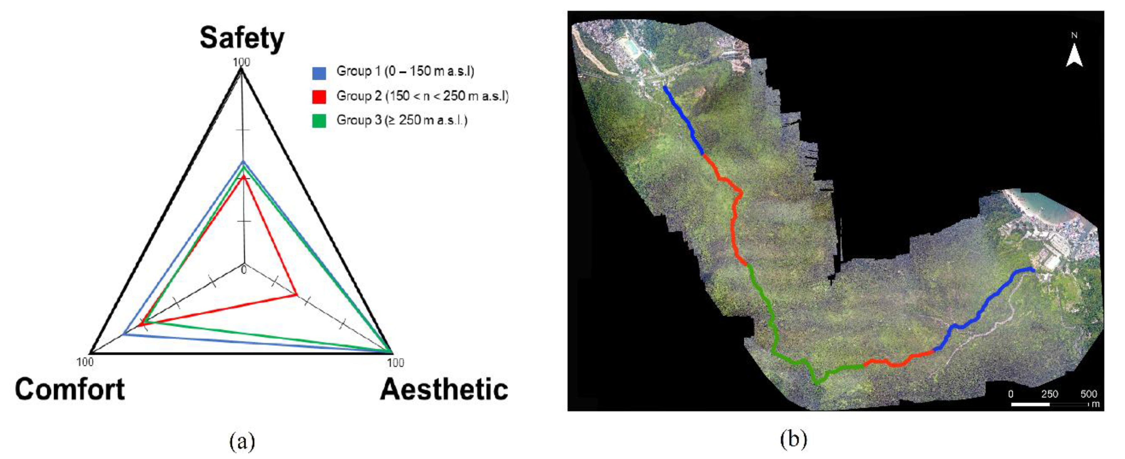
3.3. Phytotourism Products, Scenic Spots and Strength Distribution of Parameters

Based on the fieldwork data, 20 vascular plant species were highlighted to be presented as potential phytotourism products along the hiking trail (Table 4). The selected species comprised of 20 different plant species, derived from 18 different genera of 15 different families. Detailed information of these vascular plant species on their exact locations and morphological descriptions are listed in Table 4.The locations of the phytotourism products were plotted in Figure 1, in which they were indicated with green circles. Four sites, namely the waterfall area, two abandoned villages, and a sea-view site - were identified as scenic spots (Figure 1). The coordinates of the four scenic spots are shown in Table 4 and the locations were plotted in Figure 1, in which they were indicated with blue star-shapes. The calculated percentage for the safety, comfort, and aesthetic features were 64%, 80%, and 100%, for group 1 (0–150 m a.s.l.; blue line); 52%, 79%, and 43% for group 2 (150 < n < 250 m a.s.l.; red line); and 55%, 74%, and 100% for group 3 (≥250 m a.s.l.; green line), respectively (Figure 2).

4. Discussion

The application of trail condition assessment based on ground observation coupled with aerial observation, such as aircraft and satellite remote sensing, is not a novel approach [29,30]. To revive an unmaintained old trail for hiking purposes requires an unsurmountable amount of consideration in terms of its safety and suitability features. The novelty of this approach lies in the ground observation coupled with aerial drone surveillance, which resulted in detailed field data in evaluating the suitability of the old, closed-downed trail to be restored as a safe trail for hiking purposes. Through this study, we assessed the possibility for public access based on the extent of trail safety, comfort and nature experience. Ground observation is undeniably a sound method to obtain first-hand information on the trail condition, focusing on safety considerations on hikers; while the advantage of using drones in this assessment is that it is cost-effective and moreover robust in providing a clearer view from above the forest canopy, emphasizing the hiker’s comfort by immersing in the tranquilities of nature itself. On the other hand, the evaluation of phytotourism products and scenic spots adds value to the hiker’s nature experience.
Our current proposed new assessment technique may be possible to improve on the old assessment methods used by other researchers when assessing the reliability of recreational off-road vehicle trail maps [29]. The previous assessment was conducted using a combination of helicopter/field surveys, and GIS analysis. Image capturing was carried out via remote sensing, using a 35-mm film camera and handheld Kodak Digital Science Field Imaging System (FIS) 265, connected to a global positioning system (GPS) unit. When compared to our proposed method, the use of helicopter, both film and digital camera with GPS unit, could be replaced by a drone. The usefulness of drones being implemented in different fields of study is promising, especially in aspects such as agriculture and forestry [31,32,33]. A drone-based technique for topographic analysis provides better accuracy when compared to satellite-based and aircraft-based remote sensing techniques [34,35,36]. Satellite images and aircraft-based aerial photographs were common sources of aerial information during the last century [37]. However, obtaining quality resolution photos from these means is a challenging task. Although some low- to moderate-resolution satellite data can be obtained at no cost, images from very high-resolution sensors that are suitable for scientific researches are costly [38]. Images captured from satellites are also subjected to shadowing due to the oblique viewpoint, which may affect the analysis process [39]. When compared to drones, aerial mapping using aircraft could be of more or less efficient, but has a higher operational cost when the survey site is small (i.e., 5 ha), but is comparably cheaper when the area covered is large (i.e., 50 ha) [34]. Due to limitation in sensory equipment, aircraft-based remote sensing is not always available and requires relevant maintenance effort, whilst drones are easily available for purchase and do not require much maintenance in the long run. Therefore, the use of drones for image capturing is more practical in our study in comparison to the application of satellite data and aircraft aerial photography, particularly when our study site is not big and better accuracy is required to identify the gap between forest canopy where the trail lies [36]. Furthermore, aerial photos acquisition and purchase of equipment are considered to be more economical [35]. The technique is highly transferable because drones are very accessible and are increasingly used in work similar to ours [39,40]. However, our proposed technique is presently limited to only identified abandoned trails that are subjected to assessing their suitability to be revived as proper hiking trails. Although detection of both formal and informal trails is possible using drones [39,41], identification of new or potential hiking trails from a large area primarily requires high-throughput aerial information for screening purposes, preferably the satellite data [42,43].

4.1. A Safe Journey

When developing a new forest trail that is suitable for recreational activities, two major concerns are being put-forward—trail safety and minimum nature destruction [44]. In terms of safety, the occurrence of fatal and non-fatal accident cases on visitors when undergoing adventurous tours has been a global issue [45]. Such an unpleasant incident has placed the safety of visitors as a primary concern in all recreation parks. Although there are always risks and hazards to visitors participating in outdoor recreation activities in nature [46], safety is a matter decreed by law and potential threats must be kept at minimal [47]. Most of the time, if not always, outdoor accidents were likely due to lack of preparation or a sense of danger among visitors to the surroundings [46]. Hence, it is important to prioritize the safety features of a hiking trail when developing one [48]. The need to monitor the trail condition, difficulty levels, and potential hazards, such as falling trees or the presence of aggressive wildlife animals, is a requisite process in order to create a safe environment for the visitors. Based on the classification system proposed by a study [49], the interaction between risks and competencies of an outdoor activity and its venue can be categorized into four different stages namely play, adventure, frontier adventure, and misadventure. Our study site falls under “adventure”, in which the trail does not impose any feeling of being at risk or losing control on the user, while at the same time the users are fully aware of the potential risk involved in the activity able but still feel in control of the situation by making use of their skills and experiences [49]. Here, we focused on the evaluation of trail surface conditions, which is the key “facility” to hiking. Forest trails are meant to be a traveling path in nature, while the factors causing to trail degradation could be due to the intensity of usage, types and behavior of its user [50]. Excessive trampling impacts the trail’s soil surface characteristics, mechanical properties and hydrophysical behavior, causing trail degradation (also known as trail impact, trail erosion, trail wear, and trail deterioration [51]; and affecting the forest’s under-storey micro-climate [52]. Needless to say, degraded trails are trails that threaten the quality of visitor experience by making travel difficult or unsafe [51]. Relevant trail construction and maintenance actions are vital to reduce trail degradation, while poorly designed trails deteriorate quickly over time, causing environmental impacts to the surroundings and requiring greater restoration efforts [10].
Based on the assessment accomplished on the old trail using our proposed trail assessment strategy, we concluded that the old trail is still in good condition despite not being maintained over a period of time. No significant soil erosion was recorded along the trail (Table S1). Eventually, trails constructed at unstable or over-steepened slopes contributed to the higher risk and damage rate in soil erosion [53], which corresponded to our finding—most of the sampling points located at steep trails or along slopes were recorded with “bad” or “very bad” trail condition (Table S1). We suggest that the park should conduct minor maintenance on the trails marked with “bad” and “very bad” conditions in order to prevent soil erosion in the future. On the other hand, our aerial observation that provided a different perspective by highlighting stretches of the trail being exposed from above, suggested that the small patches of exposed soil surface were detected due to lack of coverage from the forest canopy (Figure 1). Although climate factors (e.g., rainfall) may have minimal effect on the trails, nevertheless it may contribute to the degradation rate [51,54].

4.2. Promotion of Nature Experience

Users search for a rewarding, enriching, adventuresome and learning experience through the course [55], and it was suggested that coupling nature experience with environmental education could be a pleasant feature for recreationists [56,57]. Realizing the impacts of nature-based tourism to environmental knowledge and behavior, the development of a hiking trail in a geopark should be equipped with such feature, thus we offered two approaches—aerial observation and identification of phytotourism products and scenic spots—to anticipate user’s ‘desired’ hiking experience. The forest canopy is part of the natural landscape in the forest [58], while trails that are exposed to direct sunlight may be less enriching for hikers [59]. For instance, the hiking experience considerably varies from walking on a trail exposed to direct sunlight as to one which is concealed under a dense forest canopy during summer. Although having different experiences are part of gains through outdoor activities [60], but it could also display an adverse effect on the user’s perspective toward a recreation site. For a hiker, discomfort due to unwanted situations is certainly a taboo, as emotionally-disturbed hikers could end up with an unsatisfactory experience, which is not a good response for a user-centered recreation site [61].
As recreation experience is dependent upon the hiker and often, and the on-site experience of the hiker is subjected to the landscape scenic beauty [62]. The identification of phytotourism products and scenic spots along the trail is one of the methods aimed to enrich the hiker’s hiking experience [28]. Educational-wise, we suggest that the labeling of phytotourim products could provide some information about the vegetation in the area, while the scenic spots identified along the trail are referred to as cultural identities of the study site. The forest is constructed by nature but does not naturally embed aesthetic features. The establishment of aesthetic elements in the forest is eventually the work of humans [63]. The waterfall and sea-view spot could be a good rest point for hikers while enjoying the scenery and the two abandoned villages, which are now ruined, could provide a visual-based history-telling scene for the hikers. Interestingly, in sampling point S24 where a cemetery was located, a 262.50 m2 land clearance was detected via aerial observation (Figure 1). The clearing imposes a visual impact on the hikers. From an environmental point of view, the event of land clearance in the area is not contributing to the ecosystem [64]. Therefore, enrichment planting could take place on this cleared land. However, from the perspective of recreation purposes, we suggest that a watchtower can be constructed for hikers to have a panoramic view of the area from a high altitude above the forest canopy. Eventually, to confirm whether or not these aesthetic features could provide maximum satisfaction to the hikers, these experiential attributes could be evaluated by the hikers [15,65], and such evaluation can be conducted after the trail is opened for public access.

4.3. A “Desired” Hiking Trail

The contradiction of protecting the natural ecosystems while catering them for recreational uses is often a tricky issue for park managers [66]. Therefore, it is proposed that the balance in the development of natural experiences should be on a sustainable basis and within the ability of nature in supplying these experiences [67]. Here, we offer a new hypothesis whereby a simple yet user-satisfied hiking trail in a national park should contain three major criteria—safety, comfort, and aesthetic value. The relationships between these three elements are visualized in Figure 2. Eventually, the three criteria were found to be closely related to each other based on several overlapping features. For example, hikers feel comfortable (comfort criteria) when not taking any risk (safety criteria) and take pleasure in maximum nature experience (aesthetic criteria), which is also being described in a study [68] that conducted an assessment of climate preferences for the practice of hiking tourism in Spain; however, scenic spots with higher aesthetic values (aesthetic criteria), e.g., waterfall and village ruins, are considered to require greater attention in terms of safety precautions (safety criteria). This is because, from an assessment on analyzing better alternative hiking routes in Calhoun County, Michigan, it was concluded that a trail with good scenery but lack of safety measurements will lead to a bad reputation, thus affecting the number of visitors [69]. These criteria are quite similar but contain fewer categories when compared to the six qualitative descriptors (i.e., safety, security, comfort and convenience, continuity, system coherence, and attractiveness) listed in the pedestrian level of service (LOS) developed by [70] and the four major categories (i.e., functional, safety, aesthetic and destinations) of physical influencing features on walking identified by one study [71]. On the other hand, we suggest that it is prudent to justify the hypothesis proposed by another study [72] that the intensity of an experience may develop during the process, but culminates towards the destination. In our opinion, if this is relevant to our trail users, it is possible that the trail will be revisited and the positive experiences will be shared among other users. Such recognition would be valuable for a hiking trail that serves its purposes, which is to promote health and nature experience.

5. Conclusions

Building on the method proposed by previous efforts coupled with the application of drones, we developed a methodology to assess the safety and suitability of an old, close-downed forest trail as an evocation to reopen it as a hiking trail. The methodology is described and supported by a hypothesis, whereby a “desirable” hiking trail constructed in the national parks should contain three major criteria, such as safety, comfort, aesthetic. The development of this methodology offers a new approach for park managers to evaluate the quality of a potential hiking trail using a direct and cost-effective, yet informative assessment, which could effectively aid in the promotion of nature-based tourism.

Supplementary Materials

The following are available online at https://0-www-mdpi-com.brum.beds.ac.uk/2220-9964/9/4/221/s1, Table S1: Score dataset obtained from the ground survey, aerial survey, and phytotourism and scenic spots analyses.

Author Contributions

Conceptualization, Shiou Yih Lee and Wenbo Liao; methodology, Shiou Yih Lee, Zhihui Chen and Kailang Guan.; ground assessment, Shiou Yih Lee, Zhihui Chen, Kailang Guan, Yirong Liu, Yongjie Cui, Wenyan Li; aerial survey and software, Chengju Du and Zhihui Chen; formal analysis, Shiou Yih Lee and Kailang Guan; resources, Hao Wu, Wenyan Li., Qiang Fan and Wenbo Liao; writing—original draft preparation, Shiou Yih Lee; writing—review and editing, Hao Wu, Qiang Fan and Wenbo Liao; funding acquisition, Qiang Fan and Wenbo Liao. All authors have read and agreed to the published version of the manuscript.

Funding

This research was funded by Shenzhen Dapeng Peninsula National Geopark Horizontal Research Grant, grant number 33000-71021140.

Acknowledgments

The authors thank the staff of Shenzhen Dapeng Peninsula National Geopark for the services rendered during fieldwork as well as Tien Ming Lee of Sun Yat-sen University, and Si Sun of South China Agricultural University, for the ideas and assistance provided during manuscript preparation.

Conflicts of Interest

The authors declare no conflict of interest. The funders had no role in the design of the study; in the collection, analyses, or interpretation of data; in the writing of the manuscript, or in the decision to publish the results.

References

  1. R Carter, E. Ecotourism in the third world: Problems and prospects for sustainability. In Ecotourism: A Sustainable Option? Cater, E., Lowman, G., Eds.; Wiley: Chichester, UK, 1994; pp. 69–86. [Google Scholar]
  2. Ross, S.; Wall, G. Ecotourism—Toward congruence between theory and practice. Tour. Manag. 1999, 20, 123–132. [Google Scholar] [CrossRef]
  3. Wunder, S. Ecotourism and economic incentives: An empirical approach. Ecol. Econ. 2000, 32, 465–479. [Google Scholar] [CrossRef]
  4. World Tourism Organization, United Nations Environment Programme (UNEP). Davos declaration: Climate change and tourism-responding to global challenges. In Climate change and tourism: Responding to Global Challenges; World Tourism Organization, Ed.; UNEP/Earthprint: Stevenage, UK, 2008; pp. 13–16. [Google Scholar]
  5. Zhao, J.; Li, S. The impact of tourism development on the environment in China. Acta Sci. Malays. 2018, 2, 1–4. [Google Scholar] [CrossRef]
  6. Kling, K.G. Paths to collaboration? A Study on Multifunctional Mountain Trails. Ph.D. Thesis, Mid Sweden University, Sundsvall, Sweden, 18 January 2019. [Google Scholar]
  7. Kling, K.G.; Fredman, P.; Wall-Reinius, S. Trails for tourism and outdoor recreation: A systematic literature review. Turiz. Međunarodni Znan. -Stručni Časopis 2017, 65, 488–508. [Google Scholar]
  8. Tomczyk, A.M.; Ewertowski, M. Planning of recreational trails in protected areas: Application of regression tree analysis and geographic information systems. Appl. Geogr. 2013, 40, 129–139. [Google Scholar] [CrossRef]
  9. Farrell, T.A.; Marion, J.L. Trail impacts and trail impact management related to visitation at Torres del Paine National Park, Chile. Leis./Loisir 2001, 26, 31–59. [Google Scholar] [CrossRef]
  10. Marion, J.L.; Leung, Y.F. Environmentally sustainable trail management. In Environmental Impact of Tourism; Buckley, R., Ed.; CABI Publishing: Cambridge, MA, USA, 2004; pp. 229–244. [Google Scholar]
  11. Hesselbarth, W.; Vachowski, B.; Davies, M.A. Trail Construction and Maintenance Notebook; USDA Forest Service and Technology & Development Center: Missoula, MT, USA, 2007. [Google Scholar]
  12. Chiou, C.R.; Tsai, W.L.; Leung, Y.F. A GIS-dynamic segmentation approach to planning travel routes on forest trail networks in Central Taiwan. Landsc. Urban Plan. 2010, 97, 221–228. [Google Scholar] [CrossRef]
  13. Yuxi, Z.; Linsheng, Z. Identifying conflicts tendency between nature-based tourism development and ecological protection in China. Ecol. Indic. 2020, 109, 105791. [Google Scholar] [CrossRef]
  14. Yang, M.; Coillie, F.V.; Hens, L.; Wulf, R.D.; Ou, X.; Zhang, Z. Nature conservation versus scenic quality: A GIS approach towards optimized tourist tracks in a protected area of Northwest Yunnan, China. J. Mt. Sci.-Engl. 2014, 11, 142–155. [Google Scholar] [CrossRef]
  15. Li, P.; Ryan, C.; Bin, Z. The motivations of Chinese hikers: Data from Ningbo. Curr. Issues Tour. 2019, 1, 1646224. [Google Scholar] [CrossRef]
  16. Carvalhinho, L.; Rosa, P.; Gomes, F. Hiking trails evaluation in the natural park of Serras de Aire e Candeeiros, Portugal. Eur. J. Tour. Hosp. Recreat. 2015, 6, 139–156. [Google Scholar]
  17. Roberson, D.N.; Babic, V. Remedy for modernity: Experiences of walkers and hikers on Medvednica Mountain. Leis. Stud. 2009, 28, 105–112. [Google Scholar] [CrossRef]
  18. Carvalhinho, L.; Frazao, H.; Moutao, J. The safety of young adolescents in nature-based sports: Risk perception and prevention. Aten. Primaria 2013, 45, 27. [Google Scholar]
  19. Zhong, L.; Buckley, R.C.; Wardle, C.; Wang, L. Environmental and visitor management in a thousand protected areas in China. Biol. Conserv. 2015, 181, 219–225. [Google Scholar] [CrossRef] [Green Version]
  20. Li, P.; Bin, Z.; Ryan, C. Hiking in China: A fuzzy model of satisfaction. Tour. Manag. Perspect. 2017, 22, 90–97. [Google Scholar] [CrossRef]
  21. Edler, D.; Keil, J.; Wiedenlubbert, T.; Sossna, M.; Kuhne, O.; Dickmann, F. Immersive VR experience of redeveloped post-industrial sites: The example of “Zeche Holland” in Bochum-Wattenscheid. Kn J. Cart. Geogr. Inf. 2019, 69, 267–284. [Google Scholar] [CrossRef] [Green Version]
  22. Walmsey, A.P.; Kersten, T. The imnperial Cathedral in Konigslutter (Germany) as an immersive experience in virtual reality with integrated 360° panoramic photography. Appl. Sci. 2020, 10, 1517. [Google Scholar] [CrossRef] [Green Version]
  23. Wang, F.; Xue, W.; Zhang, S.; Mu, J. Tourism development of Shenzhen Dapeng Peninsula Geopark. J. Huizhou Univ. 2019, 39, 112–118. [Google Scholar]
  24. Marion, J.L.; Leung, Y.F.; Nepal, S.K. Monitoring trail conditions: New methodological considerations. George Wright Forum. 2006, 23, 36–49. [Google Scholar]
  25. Ólafsdóttir, R.; Runnström, M.C. Assessing hiking trails condition in two popular tourist destinations in the Icelandic highlands. J. Outdoor Recreat. Tour. 2013, 3, 57–67. [Google Scholar] [CrossRef]
  26. Meyer, G.E.; Neto, J.C. Verification of color vegetation indices for automated crop imaging applications. Comput. Electron. Agric. 2008, 63, 282–293. [Google Scholar] [CrossRef]
  27. Otsu, N. A Threshold selection method from gray-level histograms. IEEE Trans. Syst. Man Cybern. 1979, 9, 62–66. [Google Scholar] [CrossRef] [Green Version]
  28. Mohamad, S.; Mohamed, M.; Hamdin, M.S. Potential of vascular plants as phytotourism products in Endau Rompin Johor National Park, Malaysia. Aip Conf. Proc. 2018, 2002, 020054. [Google Scholar]
  29. Welch, R.; Madden, M.; Litts, T. Off-oad Vehicle Trail Accuracy Assessment: Big Cypress National Preserve (BICY); The University of Georgia: Athens, Greece, 2001. [Google Scholar]
  30. Monz, C.A.; Marion, J.L.; Goonan, K.A.; Manning, R.E.; Wimpey, J.; Carr, C. Assessment and monitoring of recreation impacts and resource conditions on mountain summits: Examples from the Northern Forest, USA. Mt. Res. Dev. 2010, 30, 332–343. [Google Scholar] [CrossRef]
  31. Luna, I.; Lobo, A. Mapping crop planting quality in sugarcane from UAV imagery: A pilot study in Nicaragua. Remote Sens. 2016, 8, 500. [Google Scholar] [CrossRef] [Green Version]
  32. Herrman, I.; Bdolach, R.; Montekyo, Y.; Rachmilevitch, S.; Townsend, P.A.; Karnieli, A. Assessment of maize yield and phenology by drone-mounted superspectral camera. Precis. Agric. 2020, 21, 51–76. [Google Scholar] [CrossRef]
  33. Khokthong, W.; Zemp, D.C.; Irawan, B.; Sundawati, K.; Kreft, H.; Holscher, D. Drone-based assessment of canopy cover for analyzing tree mortality in an oil palm agroforest. Front. Glob. Chang. 2019, 2, 12. [Google Scholar] [CrossRef] [Green Version]
  34. Matese, A.; Toscano, P.; Di Gennaro, S.F.; Genesio, L.; Vaccari, F.P.; Primicerio, J.; Belli, C.; Zaldei, A.; Bianconi, R.; Gioli, B. Intercomparison of UAV, aircraft and satellite remote sensing platforms for precision viticulture. Remote Sens. 2015, 7, 2971–2990. [Google Scholar] [CrossRef] [Green Version]
  35. Ruwaimana, M.; Satyanarayana, B.; Otero, V.; Muslim, A.M.; Muhammad Syafiq, A.; Ibrahim, S.; Raymaekers, D.; Koedam, N.; Dahdouh-Guehbas, F. The advantages of using drones over space-borne imagery in the mapping of mangrove forests. PLoS ONE 2018, 13, e0200288. [Google Scholar] [CrossRef] [Green Version]
  36. Gao, Y.; Liang, Z.; Wang, B.; Wu, Y.; Liu, S. UAV and satellite remote sensing images based aboveground biomass inversion in the meadows of Lake Shengjin. J. Lake Sci. 2019, 31, 517–528. [Google Scholar]
  37. Luo, L.; Wang, X.; Guo, H.; Lasaponara, R.; Zong, X.; Masini, N.; Wang, G.; Shi, P.; Khatteli, H.; Chen, F.; et al. Airborne and spaceborne remote sensing for archaeological and cultural heritage applications: A review of the century (1907–2017). Remote Sens. Env. 2019, 232, 111280. [Google Scholar] [CrossRef]
  38. Carleer, A.P.; Debeir, O.; Wolff, E. Assessment of very high spatial resolution satellite image segmentations. Phytogramm. Eng. Remote Sens. 2005, 71, 1285–1294. [Google Scholar] [CrossRef] [Green Version]
  39. Cwiakala, P.; Kocierz, R.; Puniach, E.; Nedzka, M.; Mamczarz, K.; Niewiem, W.; Wiacek, P. Assessment of the possibility of using unmanned aerial vehicles (UAVs) for the documentation of hiking trails in alpine areas. Sensors 2018, 18, 81. [Google Scholar] [CrossRef] [PubMed] [Green Version]
  40. Dustin, M.C. Monitoring Parks with Inexpensive UAVs: Cost Benefits Analysis for Monitoring and Maintaining Parks Facilities. Master’s Thesis, University of Southern California, Los Angeles, CA, USA, August 2015. [Google Scholar]
  41. Grubesic, T.H.; Nelson, J.R. Detecting and monitoring informal trails in an urban mountain preserve using small unmanned aerial systems. In UAVs and Urban Spatial Analysis; Grubesic, T.H., Nelson, J.R., Eds.; Springer: Cham, Switzerland, 2020; pp. 165–187. [Google Scholar]
  42. Snyder, S.A.; Whitmore, J.H.; Schneider, I.E.; Becker, D.R. Ecological criteria, participant preferences and location models: A GIS approach toward ATV trail planning. Appl. Geogr. 2008, 28, 248–258. [Google Scholar] [CrossRef]
  43. Mohamed, R.K.; Al-Gilani, A.A. Focumenting Kara Caravan trail using multi-temporal remote sensing and GIS techniques. In Proceedings of the First National GIS Symposium in Saudi Arabia, Al-Khobar, Saudi Arabia, 21–23 November 2005. [Google Scholar]
  44. Pickering, C.; Castley, J.G.; Hill, W.; Newsome, D. Environmental, safety and management issue of unauthorized trail technical features for mountain bicycling. Landsc. Urban Plan. 2010, 97, 58–67. [Google Scholar] [CrossRef]
  45. Kortenkamp, K.V.; Moore, C.F.; Sheridan, D.P.; Ahrens, E.S. No hiking beyond this point! Hiking risk prevention recommendations in peer-reviewed literature. J. Outdoor Recreat. Tour. 2017, 20, 67–76. [Google Scholar] [CrossRef] [Green Version]
  46. Mohd Sidi, M.A. Risk & rescuing issue: Outdoor adventure accidents in protected areas of Gunung Ledang, Johor National Park, Malaysia. J. Hosp. Netw. 2019, 1, 13–17. [Google Scholar]
  47. Sadler, P. Do we need a sign on every rock in the water? Standard of care in negligence and the tourism industry in Western Australia. Legal Issues Bus. 2004, 6, 1–9. [Google Scholar]
  48. Rantala, O.; Valkonen, J. The complexity of safety in wilderness guiding in Finnish Lapland. Curr. Issues Tour. 2011, 14, 581–593. [Google Scholar] [CrossRef]
  49. Mortlock, C. The Adventure Alternative; Cicerone Press: Milnthorpe, UK, 1984. [Google Scholar]
  50. Deluca, T.H.; Patterson, W.A.; Freimund, W.A.; Cole, D.N. Influence of llamas, horses, and hikers on soil erosion from established recreation trails in western Montana. USA Env. Manag. 1998, 22, 255–262. [Google Scholar] [CrossRef]
  51. Leung, Y.F.; Marion, J.L. Trail degradation as influenced by environmental factors: A state-of-the-knowledge review. J. Soil Water Conserv. 1996, 51, 130–136. [Google Scholar]
  52. Chatterjea, K. Assessment and demarcation of trail degradation in a nature reserve, using GIS: Case of Bukit Timah Nature Reserve. Land Degrad. Dev. 2007, 18, 500–518. [Google Scholar] [CrossRef]
  53. Helgath, S.F. Trail Deterioration in the Selway-Bitterroot Wilderness; Intermountain Forest and Range Experiment Station: Ogden, Utah, 1975. [Google Scholar]
  54. Olive, N.D.; Marion, J.L. The influence of use-related, environmental, and managerial factors on soil loss from recreational trails. J. Env. Manag. 2009, 90, 1483–1493. [Google Scholar] [CrossRef] [PubMed]
  55. Read, S.E. A prime force in the expansion of tourism in the next decade: Special interest travel. In Tourism Marketing and Management Issues; Hawkins, D.E., Shafer, E.L., Rovelstad, J.M., Eds.; George Washington University: Washington, DC, USA, 1980; pp. 193–202. [Google Scholar]
  56. Russell, C.L. Ecotourism as experiential environmental education? J. Exp. Educ. 1994, 17, 16–22. [Google Scholar] [CrossRef]
  57. Ardoin, N.M.; Wheaton, M.; Bowers, A.W.; Hunt, C.A.; Durham, W.H. Nature-based tourism’s impact on environmental knowledge, attitudes, and behavior: A review and analysis of the literature and potential future research. J. Sustain. Tour. 2015, 23, 838–858. [Google Scholar] [CrossRef]
  58. Nelson, T.; Johnson, T.; Strong, M.; Rudakewich, G. Perception of tree canopy. J. Environ. Psychol. 2001, 21, 315–324. [Google Scholar] [CrossRef] [Green Version]
  59. Olivier, W. Hiking trails of South Africa; Penguin Random House South Africa: Cape Town, South Africa, 2017. [Google Scholar]
  60. Neuman, J. Education and Learning through Outdoor Activities; DUHA: Prague, Czech, 2004. [Google Scholar]
  61. Lekies, K.S.; Whitworth, B. Constructing the nature experience: A semiotic examination of signs on the trail. Am. Sociol. 2011, 42, 249–260. [Google Scholar] [CrossRef]
  62. Hull, R.B., IV; Stewart, W.P.; Yi, Y.K. Experience patterns: Capturing the dynamic nature of a recreation experience. J. Leis. Res. 1992, 24, 240–252. [Google Scholar] [CrossRef]
  63. Hull, R.B.; Robertson, D.P.; Buhyoff, G.J.; Kendra, A. What are we hiding behind the visual buffer strip?: Forest aesthetics reconsidered. J. Forest. 2000, 98, 34–38. [Google Scholar]
  64. Reside, A.E.; Beher, J.; Cosgrove, A.J.; Evans, M.C.; Seabrook, L.; Silcock, J.L.; Wenger, A.S.; Maron, M. Ecological consequences of land clearing and policy reform in Queensland. Pac. Conserv. Biol. 2017, 23, 219–230. [Google Scholar] [CrossRef]
  65. Oh, M.; Kim, S.; Choi, Y. Analyses of determinants of hiking tourism demands on the Jeju Olle hiking trail using zero-truncated negative bionomial regression analysis. Tour. Econs. 2019. [CrossRef]
  66. Kuss, R.F.; Grafe, A.R. Effects of recreation trampling on natural area vegetation. J. Leis. Res. 1985, 17, 165–183. [Google Scholar] [CrossRef]
  67. Mc Namara, K.E.; Prideaux, B. Planning nature-based hiking trails in a tropical rainforest setting. Asia Pac. J. Tour. Res. 2011, 16, 289–305. [Google Scholar] [CrossRef]
  68. Martinez-Ibarra, E.; Gomez-Martin, M.B.; Armesto-Lopez, X.A.; Pardo-Martinez, R. Climate preferences for tourism: Perceptions regarding ideal and unfavourable conditions for hiking in Spain. Atmosphere 2019, 10, 646. [Google Scholar] [CrossRef] [Green Version]
  69. Lambert, W.K. A Comparison of Alternative Route Alignments for the North Country Trail through Calhoun County, MI. Master’s Thesis, Western Michigan University, Kalamazoo, MI, USA, April 2018. [Google Scholar]
  70. Sarkar, S. Determination of service levels for pedestrians, with European examples. Transp. Res. Rec. 1993, 1405, 35–42. [Google Scholar]
  71. Pikora, T.; Bull, F.; Jamrozik, K.; Knuiman, M.; Giles-Corti, B.; Donovan, R. Developing a reliable audit instrument to measure the physical environment for physical activity. Am. J. Prev. Med. 2002, 23, 187–194. [Google Scholar] [CrossRef]
  72. Borrie, W.T.; Roggenbuck, J.W. The dynamic, emergent, and multi-phasic nature of on-site wilderness experiences. J. Leis. Res. 2001, 33, 202–228. [Google Scholar] [CrossRef]
Figure 1. Ortho-mosaic map obtained from the aerial observation conducted along the study site using a Mavic 2 Pro (DJI, China) drone. The trail is highlighted in yellow and the area that is exposed from above along the trail, is indicated with red color. The locations of the sampling points, phytotourism products, and scenic spots were marked along the trail, while the legend corresponded to the symbols used on the map.
Ijgi 09 00221 g001
Figure 2. A visual-based analysis carried out to display the distribution of strength between the three groups based on safety (trail condition), comfort (canopy cover) and aesthetic (phytotourism products and scenic spots) at three different altitude groups of the study site. (a) Strength distribution plot for the three major elements in developing a hiking trail, namely safety, comfort, and aesthetic, as proposed in this study for the three sampling point groups. (b) Trail is classified into three groups based on altitude. The legend indicates the color code for the results for each group.
Ijgi 09 00221 g002
Table 1. Condition scale for hiking trails used in this study, which was adapted from the description in [24].
ScaleConditionScore according to ClassificationDefinition
Trail Damage LevelTrail VisibilityVegetation cover Disruption LevelParent Material Disruption LevelSoil Erosion
0Very good0–1undamaged trailhardly seenlittle or nolittle or nono
1Good2–4lightly damaged trailnoticeablesignificantsignificantno
2Acceptable5–7moderately damaged trailobviousconsiderableconsiderablesignificant
3Bad8–10highly damaged trailobviousheavily degradederodedactive
4Very bad11–12severely damaged trailobviousvegetation deaderodedstriking
Table 2. Classification system for hiking trail condition assessment and forest canopy coverage, which was adapted from the description in [25] with minor adjustments to fit the geographical condition of Guangdong province.
IndicatorScoreDefinition of Assessment
1Main trail width0Trail is hardly visible (unclear)
1Simple trail <0.1 m
2Trail 0.5–1.0 m, 1–2 side paths
3Trail >1.0 m. Multiple side paths
2Affected area width0Total width <1.0 m
1Total width 1.0–10.0 m
2Total width 11.0–20.0 m
3Total width >20.0 m
3Trail depth (based on deepest part of the trail)0<5.0 cm
15.0–10.0 cm
210.1–25.0 cm
3≥ 25.1 cm
4Ecosystem type0No apparent impact. Trail is hardly visible.
1Visual impact, but no major impact in the trail compared to the surroundings (2×2 m2). Depression noticed in the vegetation cover and/or in the topsoil.
2Clear impact. Vegetation dead and/or clear vegetation changes. Soil compacted.
3Significant and permanent impact. Vegetation and/or topsoil has disappeared. Clear and permanent changes in the soil/gravel cover.
5Soil erosion0No erosion
1Breaking or cracking edges
2Gullies formed and exposed roots
3Transformation of material due to wind and water erosion both in the trail and off-trail
6Canopy cover081%–100% coverage
161%–80% coverage
241%–60% coverage
321%–40% coverage
40%–20% coverage
Table 3. Results of one-way ANOVA on the mean difference between trail condition and the percentage of canopy coverage above the 44 sampling points in the study site. The significance difference (p) was set at ≤0.05.
Source of VariationSum-of-Square (SS)Degree of Freedom (df)Mean Square (MS)F value (F)P-value (p)F Critical Value (F crit)
Between groups7.68217.6926.0280.016 *6.939
Within groups109.591861.274
Total117.27387
Note: * denotes p ≤ 0.05
Table 4. Vascular plants and scenic spots recorded along the trail that are suitable as phytotourism products and aesthetic features to the hiking experience. The locations of the plants and scenic sports are plotted on the study site map developed from the aerial observation in Figure 1.
No.FamiliesSpeciesCommon NameCoordinatesPhytotourism Characteristics
1CibotiaceaeCibotium barometz (L.) J.Sm.Golden chicken fern22°32’20.25” N, 114°33’13.16” EFern. Comes with a creeping rhizome that is covered by long, soft, golden-yellow hairs, resembles a golden-haired dog.
2DipteridaceaeDipteris chinensis Christ-22°32’21.10” N, 114°33’54.47” EFern. Comes with broad-lobed fronds that look like a Chinese handheld paper fan.
3EuphorbiaceaeMallotus paniculatus (Lam.) Mull.Arg.Turn-in-the-wind22°32’46.15” N, 114°33’01.51” ETree. Comes with pistillate inflorescence and flowers heavily during Summer and Autumn seasons.
4FabaceaeBauhinia glauca (Benth.) Benth.Glaucous climbing bauhinia22°32’19.30” N, 114°34’06.97 ELiana. Large, umber-form, white-colored inflorescence during Spring season. It comes with bi-lobed, notched apex and base leaves.
5 Ormosia semicastrata HanceSoft-fruited ormosia22°32’13.33” N, 114°33’37.05” ESmall tree. Produces attractive, bright red-colored fruits.
6FagaceaeCastanopsis hystrix Hook. f. and Thomson ex A. DC.Red cone22°32’29.31” N, 114°33’09.16” ETree. Comes with a tall and straight bole and produces purple-brown young shoots
7 Quercus auricoma A.Camus-22°32’19.98” N, 114°33’55.47” ETree. Nut-producing tree that comes with tall and straight bole.
8 Quercus myrsinifolia Blume.Chinese evergreen oak22°32’19.43” N, 114°33’58.46” ETree. Nut-producing tree that comes with tall and straight bole.
9GleicheniaceaeDiplopterygium cantonensis (Ching) Nakai-22°32’19.02” N, 114°33’13.25” EFern. It comes with glaucous leaves abaxially and glabrous, pinnate fronds.
10GramineaeIndocalamus sinicus (Hance) NakaiChinese cane22°32’57.21” N, 114°32’58.89” E; 22°32’18.97” N, 114°33’49.95” EBamboo. Form dwarf scrub and has green internodes, but straw-colored when dry.
11IteaceaeItea chinensis Hook. et Arn.Chinese sweetspire22°32’28.69” N, 114°33’55.01” ESmall tree. Produces numerous quantities of white-colored flowers during Spring season.
12LauraceaeLitsea rotundifolia Hemsl. var. oblongifolia (Nees) AllenOblong-leaved litseaPresent along the trailShrub. Produces red-colored young leaves during Spring season.
13 Machilus chekiangensis S. LeeZhejiang machilus22°32’13.33” N, 114°33’37.05” ETree. Produces red-colored young leaves during Spring season and globose fruit that is attached with purplish-red pedicel during the Summer season.
14MoraceaeFicus tinctoria subsp. gibbosa (Bl.) CornerStrangler fig22°32’11.08” N, 114°33’28.78” ETree. Dominant tree species that have coarse bark. Its globose, pear-shaped figs attract birds and small animals as food sources.
15 Ficus variegata Bl.Common Red-stem fig22°32’11.08” N, 114°33’28.78” ETree. Dominant tree species that produce red with green stripes and spots figs during mature.
16MyricaceaeMyrica rubra (Lour.) S. et Zucc.Chinese bayberry22°32’21.28” N, 114°33’5203” ESmall tree. Produces red-colored fruits during the Summer season.
17PhyllanthaceaeBischofia javanica Bl.Bishop wood22°32’11.08” N, 114°33’28.78” ETree. Dominant tree species that comes with broad palmate leaves.
18RosaceaePhotinia raupingensis KuanRauping photinia22°32’19.26” N, 114°34’01.14” ESmall tree. Produces red-colored fruits during the Autumn season.
19SapindaceaeLitchi chinensis Soon.Lychee22°33’’06.13” N, 114°32’4710” ETree. Produced large inflorescence and red young leaves during Spring season and red-colored fruits during the Summer season.
20TheaceaePolyspora axillaris (Roxb. ex Ker Gawl.) SweetFried eggplant22°32’09.65” N, 114°33’11.13” ESmall tree. Produces large, white flowers during Autumn and Winter season.
Scenic spots
NoNameCoordinateDescription
1Waterfall area22°32’26.01” N, 114°32’56.66” ELocated at the highest altitude of the trail. Consists of boulders with a flat surface suitable for picnic
2Old village22°32’10.29” N, 114°33’32.02” ERuins of old village huts that are suitable as photo-taking backgrounds
3Old village22°32’14.29” N, 114°33’40.60” ERuins of old village huts that are suitable as photo-taking backgrounds
4Sea-view spot22°32’38.87” N, 114°33’47.07” EA clear panoramic view of the Yangmeikeng village and the sea from afar

