Effectiveness of School Site Decisions on Land Use Policy in the Planning Process


Department of Geomatics Engineering, Faculty of Engineering, Giresun University, 28200 Giresun, Turkey
ISPRS Int. J. Geo-Inf. 2020, 9(11), 662; https://0-doi-org.brum.beds.ac.uk/10.3390/ijgi9110662
Submission received: 17 September 2020
/
Revised: 30 October 2020
/
Accepted: 31 October 2020
/
Published: 3 November 2020
Abstract
:The school site is a key element of the educational process, as children spend a large amount of their time there. Schools that are well-located, designed within a systematic plan, safe, and operated in an efficient manner contribute to the development of society. Since land is a scarce resource, optimal land use is a spatial necessity. In developed societies, these usage preferences are planned and presented to decision-makers according to criteria, such as distance, slope, population, land use, etc., that are related to industry and agriculture. Suitable investment areas are often not mapped in development plans. This deficiency arising from planning also appears in the determination of school site locations. In this research, a real case study was conducted to solve the problem presented. The most used school sites’ criteria were determined from the literature and those criteria were weighted with the analytical hierarchy process method. A cost–surface map of the study region was produced and associated with the implementary development plan. It was obtained from the cost surface map that suitable school sites are planned for urban, commercial, or different purposes. Additionally, possible locations for the school site in the region were determined and mapped for a future planning purpose, and the sizes of existing school campus sites in the region were analyzed. When existing campus areas were evaluated according to the number of school students, we found that only 40% of the schools were suitable. As one of the major findings, 210 possible school sites with a size of at least 2 ha were determined and mapped in Giresun, Turkey. For these reasons, clearly identifying the investment areas and transferring them to the plans is essential for sustainability.
1. Introduction
As a reality faced by the entire world, land is considered a scarce resource in Turkey [1]. This scarce resource must be used carefully by humanity [2,3]. A rising global population has brought land management problems [4]. Human beings, who use the Earth as their home, have to use the land in the most suitable form for nature, considering all natural formations [5,6]. For this purpose, earthquake fault lines, areas with high tsunami risk, deserts, creek beds, sea and ocean coasts, forest areas, volcanic sites, erosion sites, avalanche potential slopes, etc., should be identified [7]. Otherwise, there may be a risk of encountering some of the numerous problems caused by land property [8]. Countries also plan how to use the land they own and provide appropriate uses for these plans. The current physical characteristics of soil and land need to be considered during planning. According to these data, land use plans are prepared [9]. Healthier living spaces can be created in accordance with those plans [5,10]. Education areas are also an important part of planning.
Education is the most important factor in the development process. In developing countries, people’s educational success is directly related to individual gains and employment opportunities in the labor market. Education, therefore, affects not only the development of a country but also individual development as well as the socioeconomic development of the society, such as the living conditions of the population. Education affects various aspects of development, such as cognitive competence, literacy, numerical competence, and problem-solving behaviors [11]. Therefore, it is an essential factor in the development of a country [12]. As a result, educational planning is important, and the selection of locations for school sites is an important component of this planning.
As one of the emerging countries, Turkey is trying to adapt to the technological, social, and economic changes brought about by the 21st century. While Turkey is adapting to these changes, its population is increasing. Turkey’s population reached over 83 million people at the end of 2019 [13]. This population increase has revealed the necessity of establishing a good urban development planning process and of increasing the number of schools to provide education and training services for the younger generations [14].
School sites are a key factor in the educational process, and children spend most of their time at school when they are outside their homes. Schools that are well-located, designed within a systematic plan, safe, and operated in an efficient manner contribute to the development of society. Schools are expected to protect and sustain the existing culture of the society and to develop and change the society in which they are located. Therefore, schools need to be active and dynamic structures. This dynamism is facilitated by the establishment of adequate physical spaces in schools.
However, the choice of school sites is a complex problem that involves the evaluation of many different criteria (technical, political, social, environmental, and economic). Multi-criteria decision analysis (MCDA) integrated with geographic information systems (GISs) can be used to solve such complex problems [15]. MCDA and GIS can be combined into a tool that can manage large amounts of input data from different sources. This tool can operate effectively, rapidly, and at a low cost in the selection of sites. With the accessibility of remote sensing data and the development of GIS technologies, the use of MCDA for site selection has become increasingly common in recent years. Many studies have been conducted using MCDA integrated with GIS for the selection of locations for various purposes, such as school sites [16,17,18,19,20,21,22,23,24,25,26], landfill or solid waste sites [27,28,29,30,31], land use suitability assessments [32,33,34,35,36], urban development [15,37,38], sustainable urban center sites [39], fire station sites [40], aquaculture site selection, marine spatial planning [41,42], and energy plant sites [43,44].
The analytic hierarchy process (AHP) developed by Saaty [45] is a decision-making technique that uses binary comparisons to level the weights of the parameters [46]. This technique is one of the methods commonly used in MCDA with GIS. Today, it is used extensively in land suitability analysis (e.g., [18,25,27,30,44,47]).
Although there are studies in the literature focused on school sites, they are deficient in proposing building models for the selection of school site locations. In this study, the lack and inability of the current implementary development plan were revealed. Using the AHP process, suitable school site locations criteria were weighted. Integrated MCDA and GIS were used to determine and map suitable school area locations in the study region. Data from school site selection are provided to plan the other investment area in the implementary development plan. Sensitivity tests were performed by conducting sensitivity analyses related to the study, and the effectiveness of the methodology was verified. Moreover, suitability of existing school campus areas was determined by the population of school students in the study region.
2. Materials and Methods
The spatial data of the study area consisted of 1/25,000-scale standard topographic maps, geological maps, digital soil maps, land cover maps, and other maps produced by public and government institutions. Available data from administrative units, population statistics, etc., local authorities, and the Turkey Statistical Institute were complemented by integrating data obtained from the National Address Database. The thematic maps generated from these data indicated the spatial distribution of the values of the parameters in the study area being analyzed.
2.1. City Planning
In Turkey, the regional plans, spatial strategy plans, environmental plans, master zoning plans, and implementary development plan are the procedures by which important judgments are carried out for modern urbanism and the sustainable use of agricultural sites in the public interest by the classification of land and real estate [3,48,49,50]. The decision-makers determine whether the land will be converted into a natural resource, public sphere, or investment area.
The systematic and gradual unification of plans, which is a critical urbanism mechanism, was a rule of Turkish Zoning Law, as shown in Figure 1. Zoning plans can be classified as upper- and sub-scale plans. The main principles related to the field of planning are determined in the upper-scale plans. The sub-scale plans, such as those of the implementary development plan, involve scaling down to the parcel as the base. Public authorities build public services, such as roads, schools, and parks based on the sub-scale plan, whereas private property owners design their real estate following the function in the zoning plan. With the 1/1000-scaled implementary development plan (implementary zoning plan), the immovable property in private ownership is directly associated with the plan [3].
Physical planning represents a process that sets out to solve a certain set of problems. The emphasis of this study was taking precautions before future problems arise by determining the location and size of the existing or planned school sites in the implementary development plan before the plan is made. In this context, the deficiencies in the current situation were revealed, the school area locations were determined in the light of the specified criteria and the problems were minimized by those criteria.
2.2. Study Area
The Giresun province, located at 40°54′54.7″ N, 38°22′58.8″ E and comprising a 6934 km2 area in northeastern Turkey, was chosen to explore the methodology. Although the population density along the coastline is above the provincial average, moving from the coastline to the interior, this ratio decreases significantly below the provincial average. Researchers showed that 54.95% of the general population lives in 30% of the general geographic area, including 28 coastal provinces in Turkey [51]. Examination of the landforms shows that the province has rough terrain conditions with the uppermost surface forming the Giresun mountains, which cover the strip between the narrow, low plains along the Black Sea coast and the Kelkit Stream Valley to the south. The mountains appear as a wall parallel to the coast and have an average height of 2000 m, but they reach over 3000 m in some places. The extension of the Giresun mountains parallel to the coast causes the division into two different climatic zones found in the province. The land in the province consists of 25% agricultural land, 34% forest and hazelnut plantations, 18% meadow and pastureland, and 25% non-agricultural land [52].
2.2.1. Educational Facility Area Size
The decisions regarding educational facility areas in the province and their spatial qualities have important consequences in terms of child development as well as the quality of education [53,54]. The field sizes of the educational facilities, the class customs, and the number of students are related to each other. In addition, when planning a location for a school building in a particular area, the corresponding improvement in solar gains is important. Those in the indoor environment of the school building should be able to benefit directly from optimum daylight and operating costs should be reduced. The daylight should also ideally come from between the east and the south to take advantage of solar gains. This maximizes solar gains in the early hours of the morning and reduces the likelihood of overheating in the afternoon. International studies recommend that 0.77 ha be designated as school locations for single-story schools with 4–8 classrooms, 1.14 ha for schools with 8–16 classrooms, 1.6 ha for schools with 16–24 classrooms, and 2.2 ha for schools with 24–32 classrooms [55]. Additionally, the General Directorate of Spatial Planning of the Ministry of Environment and Urbanization in Turkey determined the standards and minimum area sizes for minimum social and technical infrastructure areas in different population groups [56].
2.2.2. School Site Selection Index
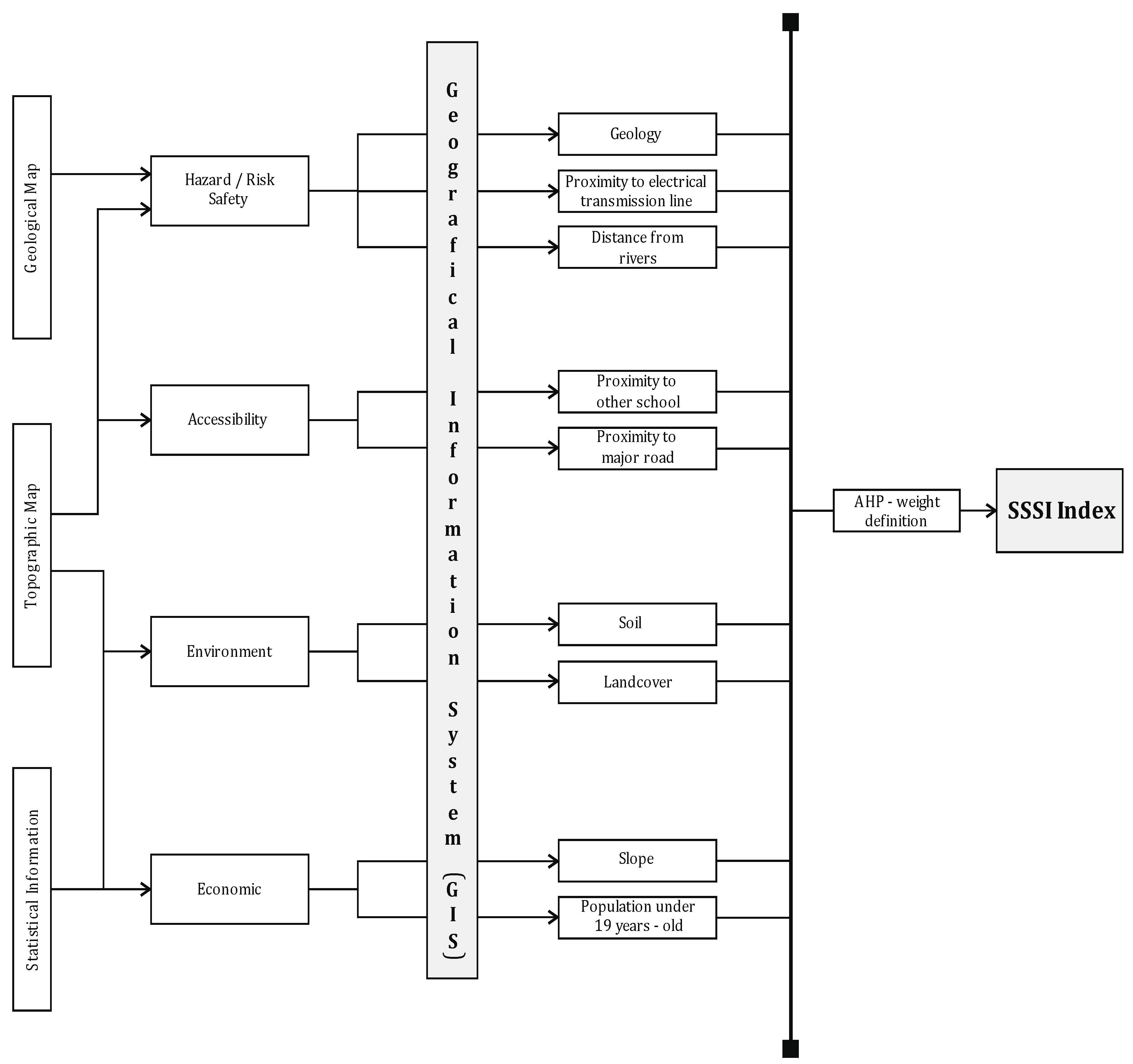
In this study, an integrated methodology was established. Accordingly, a GIS index model was developed to identify suitable regions for school site selection. The advanced model performed a multi-criteria decision analysis that included a school site selection index (SSSI). The SSSI was designed to help identify appropriate school sites.
The proposed methodology is shown in Figure 2. Initially, the information from the various data sources (geological and topographic maps, statistical information) was fed into the GIS. This information was processed and, by determining the weights of the parameters, the results were finalized with the SSSI.
2.2.3. Parameters in SSSI
The SSSI consists of nine parameters: Distance from rivers (m), proximity to electrical transmission lines (m), geology, distance from schools (m), proximity to main roads (m), land use/land cover, soil, population aged under 19 years (per pixel), and slope (°) (Table A1). Thematic maps for each parameter were generated.
2.2.4. Analytical Hierarchy Process
The importance of effective decision-making criteria and the ranking of decision alternatives was realized through the use of pairwise comparisons [57]. The method creates and applies a hierarchy of criteria to explain the problem.
The choice of a hierarchical structure for solving problems in AHP means that the problem is divided into various levels. The method allows decision-makers to effectively compare criteria and sub-criteria. The objective is clearly expressed at the top of the hierarchy [58]. The criteria that will directly affect the objective are below the objective, and the alternatives to be selected are at the bottom [59].
Extensive criteria are separated into sub-criteria and placed in the hierarchy. The relative significance of the criteria at each level of the hierarchy is obtained by pairwise comparison according to the criterion located at an upper level [38]. The factors determined for the selection of the safe school sites for our study area and each factor were weighted by AHP in Table A2.
2.3. School Site Selection Index Parameters
2.3.1. Population Aged under 19 Years (per Pixel)
The total population of Giresun province is 448,400. There are 10 elementary schools, 13 secondary schools, and 17 high schools in 16 neighborhoods that comprise the city center in Giresun province (Table A3). The number of students and campus area sizes of the designated schools were investigated. We found that 3 out of 10 primary schools, 4 out of 13 secondary schools, and 8 out of 17 high schools met international and national criteria for campus area size.
2.3.2. Distance from Existing Schools
The distance to another school, based on how far a student would have to walk, was one of the important factors used in the analysis. In the literature, a walking distance of 1–2 km from the school is recommended, while the recommended walking distance is 2.4 km in the United States. When determining the optimal buffer distances from schools, the School Rules-Based Guidelines [60] were used. From this point, the distances between the schools should be determined and given in Table A2.
2.3.3. Proximity to Main Roads
Schools must be easily accessible for transportation, however, because of noise, air pollution, and other reasons, they should not be located near main roads [61]. In addition, vehicle transport produces toxic substances that have an adverse effect on human health. Several research reports have been published on the health risk of students in schools close to large road networks. In these reports, students were shown to be at high risk for heart and lung problems, whereas after a distance of 150 m, the risk was found to be significantly reduced. Considering these reports and the condition of the study area, the limitation of the proximity to the main road limitation was determined, and 300 m was chosen as the distance suitable for the study, while all the possible school site locations were analyzed via the weighted approach [62].
2.3.4. Distance (m) from Rivers
Considering the topographic structure of the study area, buffer zones in the range of 0‒600 m were determined for this criterion. According to Kazakis et al. [63], the risk of flooding is high at a distance of less than 100 m from a river, while the risk at distances of more than 2000 m has no risk. Schools should be placed outside a flood zone due to risk of personal injury, loss of life, and substantial property damage. Since no effective flood registration information was available for the region, the study was conducted based on the literature and the buffer limits were determined.
2.3.5. Land Use
Land use plans are important in the development of zoning plans. Selection of school sites should also be based on zoning plans. Sub-criteria were determined and rated based on general land use in the form of dense forest, seasonal agriculture, agricultural areas, wetlands, rocky areas, open areas, and other areas.
2.3.6. Slope (°)
According to paragraph (g) of Article 1 of Communiqué No. 2010/2630 of the Turkish Ministry of National Education on the “Principles for Opening and Closing of an Institution”, selection of a location is one of the important criteria. When a school is located on a deep slope, it creates many problems. For example, natural disasters, such as landslides, avalanches, and rock falls frequently occur on steep slopes. Additionally, the construction of schools on steep slopes creates many difficulties, especially from the economic aspect.
In this context, the digital elevation model (DEM) was transformed into a slope raster data set using ArcGIS (version 10.2) software positional analysis, and the slope values are expressed as percentages. These values were classified for use in the analysis.
2.3.7. Soil
According to the Turkish Land Use Capability (AKK) system, the soil is grouped into eight classes ranging from Class I, which is the best, easiest, and most economical to cultivate without erosion, to Class VIII, which is unsuitable for any type of agriculture. The land classes in a planning area are divided into three groups in terms of settlement eligibility [64].
- Absolute protected areas: Class I, Class II, and Class III farmland;
- Priority protected areas: Class IV, Class V, and Class VI farmland;
- Areas that can be settled: Class VII and Class VIII farmland.
2.3.8. Proximity (m) to Electrical Transmission Lines
Schools should be far away from power transmission lines to ensure that pupils and school staff are protected from high voltage electricity. Accordingly, buffer zones of 150 m were determined [62].
2.3.9. Geology
An examination of the general geological structure of the region showed Upper Cretaceous volcanic face terrain covering a very large area, especially in the northern part. The core of the Giresun mountains forms a granodiorite base. Glacial forms are found in the northern Karagöl mass in the western part of the mountains. The Upper Cretaceous in southern Alucra and Lower Cretaceous folds with flysch layers in the Sarıçicek Mountain constitute the main structure, and gypsiferous clays belonging to the Oligocene–Miocene age are found in the Şebinkarahisar District to the west [52].
The most suitable areas, suitable areas, non-suitable areas, and restricted areas were determined as sub-criteria, and buffer zones were formed for the selection of suitable school sites in the study area.
3. Results
3.1. Interpolation of Maps
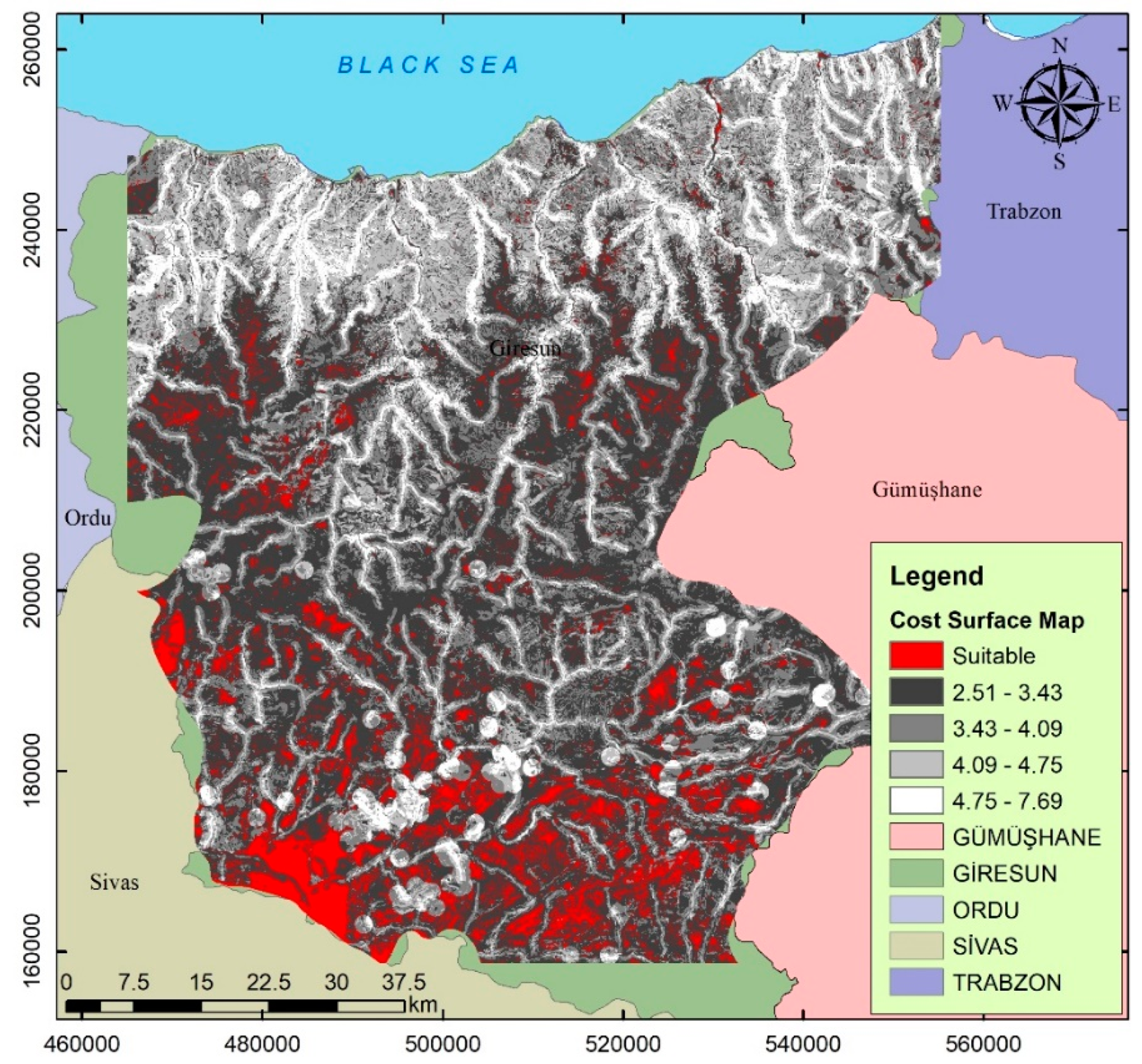
The proposed methodology combined the selected parameters linearly, considering the relative weights. As a result, cost–surface maps were created using the criteria and sub-criteria defined for the study (Figure 3 and Figure 4).
Suitable school site locations are predominantly located in the southern part of the study area, as seen on the cost–surface maps. In these regions, there are few settlements and the areas are unplanned. For this reason, this study may serve as a basis for choosing suitable sites when developing future plans.
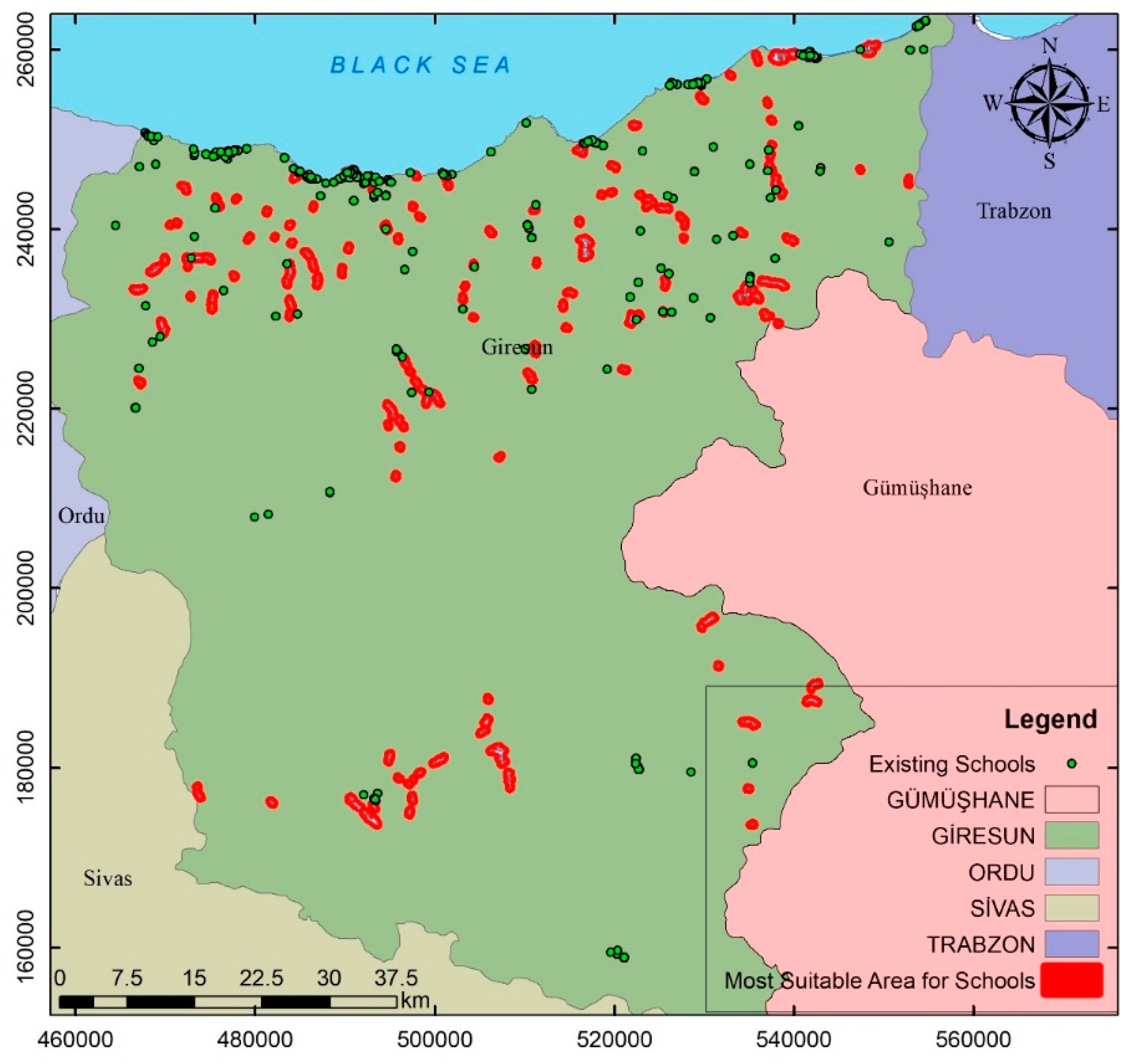
As a final stage, the cost–surface map of existing school areas was evaluated. The cost–surface map is shown in Figure 5. From the cost surface map, places with a score of six or above that are suitable for a school site were determined. In addition, sites with a minimum of 20,000 m2 (2 ha) were selected from the available areas. Suitable school sites were evaluated given these criteria and the best 210 school site locations are indicated on the map in Figure 5. Evaluations and analyses showed that some potential school sites were used for different purposes and buildings.
3.2. Validation—Sensitivity Analysis
To evaluate the sensitivity of the study, the “distance from rivers” layer was removed from the analysis (Sensitivity 1). Then, the “distance from rivers” and “slope” layers were removed (Sensitivity 2). Finally, the “distance from rivers”, “slope”, and “land use” layers were removed from the analysis (Sensitivity 3). The accumulated cost surface values that were driven from normalized factor/criteria score result are shown in Table 1.
4. Discussion and Conclusions
To determine the suitability of the sites where schools will be established and to determine the land class, an application was sent to the agricultural organization in the relevant region. Because the current cadaster data do not have enough information about the nature of the land, similarly, farmland was classified within the scope of cadaster studies (absolute farmland, marginal agricultural land, etc.) and was associated with cadaster data. It is clear that this study will contribute to the selection of investment environment locations [7].
The combination of GIS with different MCDA methods can be used in the selection of suitable sites. The GIS-based AHP offers valuable feedback for decision-makers. By applying a comprehensive and easy-to-use procedure that can be easily understood by non-specialists, it presents a straightforward output. However, there is no standardization in the studies in the literature. Whereas the criteria and their weight in this study are in good agreement with the research studies in the literature, the SSSI criteria were additionally associated with the implementation of a zoning plan in this study.
The AHP method was used to extract the relative importance of the evaluation criteria, and GIS was used to create spatial identification and maps of the evaluation criteria. In this study, a methodology that defines safe school site zones and can be applied to different regions was developed. This is important for decision-making because it can create an important road map for the selection of appropriate school sites when required. For safe school site estimation, the recommended SSSI processed the information of nine parameters and created independent thematic maps for each parameter. Thus, the most appropriate locations for safe school sites were identified and presented. In the unplanned areas on the map, the abundance of appropriate school sites stands out. In this situation, this study can serve as an effective source for the selection of school site locations when developing new plans.
When cost surface maps are examined, suitable school site locations appear predominantly in the southern part of the study area. In these regions, settlements are few and areas are unplanned. Therefore, our findings can form the basis for choosing appropriate areas when making plans. The cost–surface map was also obtained using the simple additive weighting (SAW) method. The SAW cost–surface map was compared with the AHP and showed good agreement. Whereas the focus of good agreement was the SSSI, the AHP and SAW methods were not compared in detail.
In measuring the spatial competence of primary education facility areas, the principally accepted criterion is the minimum area size per individual. In the research, as a result of the analyses conducted within the scope of spatial competence, we determined, with accessibility indicators and the inspections of the produced analytical maps, that 30% of primary school areas, 32% of secondary school areas, and 48% of high school areas could meet the minimum education field criteria in Giresun province.
We evaluated 210 possible school sites, which are indicated in the map. This overlap showed that the most suitable areas correspond to different functions, while only a few of them are school sites. Qualitative criteria must be considered in the selection of the location of education. We think that qualitative criteria will be useful in the planning stage if the locations of education areas throughout the country are determined using the criteria in this study. Analysis studies should be performed using future population projections with the aim to determine the quantity of new school sites.
In this context, investment plans should be shown on 1/100,000-scaled environmental plans. Thus, since the legal objections regarding the practices are specified on a higher scale, the concept of public benefit will not be overturned by the courts. Otherwise, most of the applications can be stopped legally.
The SSSI was constructed as a basis for future studies. Appropriate school site locations can be selected in the desired regions using the index. However, the outputs of the SSSI should be evaluated for the development of zoning plans. School sites to be placed in zoning plans can be optimally determined using the index. The outcomes of these kinds of scientific decision-making tools can be effective in resolving conflicts of interest and finding solutions to political problems.
Funding
This research received no external funding.
Conflicts of Interest
The author declares no conflict of interest with regard to the publication of this paper.
Appendix A
A detailed literature review was conducted and all relevant criteria for the selection of the most suitable and safe school sites were determined and categorized. In addition, the frequency of use of sub-criteria is given in Table A1. The most used criteria, sub-criteria, and determined weights with the AHP method are given in Table A2. Table A3 shows the sizes and locations of the school campus areas.

Table A1.
Literature review of criteria for determining school site selection.
| Category | Criteria | Literature Review | Frequency | ||||||||||||
|---|---|---|---|---|---|---|---|---|---|---|---|---|---|---|---|
| [65] | [16] | [66] | [18] | [67] | [68] | [69] | [12] | [20] | [21] | [70] | [24] | [26] | Total | ||
| Hazard/Risk/Safety | Avalanche (snow/ice) | 3 | |||||||||||||
| Bank erosion | 5 | ||||||||||||||
| Flood areas | 12 | ||||||||||||||
| Landslide | 5 | ||||||||||||||
| Rockfall | 3 | ||||||||||||||
| Underground flooding | 3 | ||||||||||||||
| Earthquake zones | - | ||||||||||||||
| Geology | 3 | ||||||||||||||
| Proximity to high voltage power lines | 1 | ||||||||||||||
| Hazardous waste | 3 | ||||||||||||||
| Enviromental/Geographic | Distance from streams | 11 | |||||||||||||
| Elevation and slope | 11 | ||||||||||||||
| Land cover | 7 | ||||||||||||||
| Natural heritage areas | 4 | ||||||||||||||
| Noise level | 3 | ||||||||||||||
| Air Pollution | 5 | ||||||||||||||
| Vegetation type | - | ||||||||||||||
| Visibility | - | ||||||||||||||
| Presence of sensitive ecosystem | - | ||||||||||||||
| Land use type | 6 | ||||||||||||||
| Rainfall Intensity | - | ||||||||||||||
| Economic | Medical facility | 4 | |||||||||||||
| Emergency communication | 3 | ||||||||||||||
| Safe haven | 3 | ||||||||||||||
| Transformers | 6 | ||||||||||||||
| Proximity to residential areas | 7 | ||||||||||||||
| Proximity to tourist areas | 4 | ||||||||||||||
| Proximity to agricultural areas | 1 | ||||||||||||||
| Population density | 10 | ||||||||||||||
| Social/Accessibility/ Infrastructure | Distance from existing schools | 11 | |||||||||||||
| Distance from roads | 13 | ||||||||||||||
| Existing fire stations | 1 | ||||||||||||||
| Existing police stations | 1 | ||||||||||||||
| Existing libraries | 2 | ||||||||||||||
| Industrial areas | 3 | ||||||||||||||
| Commercial areas | 2 | ||||||||||||||
Table A2.
Datasets used in the analysis.
| Category | Criteria | Sub-Criteria | Rating Score | Weight (%) |
|---|---|---|---|---|
| Hazard/Risk/Safety | Distance from rivers (m) (D) | <150 150–300 301–450 451–600 >600 | 10 8 6 4 2 | 0.119 |
| Proximity to electrical transmission lines (m) (H) | <150 150–300 301–450 451–600 >600 | 10 8 6 4 2 | 0.028 | |
| Geology (I) | The most suitable Suitable Unsuitable Restricted | 0 2 4 6 | 0.019 | |
| Accessibility | Distance from schools (m) (A) | <800 801–1300 1301–1800 1801–2400 >2400 | 10 8 6 4 2 | 0.240 |
| Proximity to main roads (C) | <150 150–300 301–450 451–600 >600 | 10 6 2 4 8 | 0.157 | |
| Environmental | Land use (E) | Forest Seasonal agriculture Agricultural areas Wetlands Rocky areas Open areas Other | 9 2 1 10 5 6 0 | 0.078 |
| Soil (G) | Class I Soil (Good agricultural land) Class II Soil Class III Soil Class IV Soil Class V Soil Class VI Soil Class VII Soil Class VIII Soil | 10 7 6 5 4 3 2 1 | 0.043 | |
| Economic | Population aged under 19 years (per pixel) (B) | 0 0.01–0.03 0.04–0.07 0.08–0.17 >0.17 | 10 8 6 4 2 | 0.237 |
| Slope (°) (F) | <10 10–15 16–20 21–25 >25 | 2 4 6 8 10 | 0.078 |
Table A3.
Giresun/Center (primary, middle, high school) areas.
| Giresun/Center (Primary, Middle, High School) | ||||||
|---|---|---|---|---|---|---|
| School Name | Building Area (m²) | Annex (m²) | Garden Area (m²) | Total Area (m²) | Location (m) | |
| AKSU District | Y (m) | X (m) | ||||
| ABACIBÜKÜ PRIMARY SCHOOL | 780.0 | - | 4525.55 | 5305.55 | 452,652.78 | 4,530,933.59 |
| ZÜBEYDE HANIM VOCATIONAL AND TECHNICAL ANATOLIAN HIGH SCHOOL | 1720.0 | 630 | 3812.02 | 6162.02 | 452,866.79 | 4,531,008.40 |
| ANATOLIAN IMAM HATIP HIGH SCHOOL | 1540.0 | - | 3780.00 | 5320.00 | 452,924.74 | 4,530,900.71 |
| 15 TEMMUZ ŞEHİTLER AKSU ANATOLIAN HIGH SCHOOL | 1000.0 | - | 2243.00 | 3243.00 | 452,771.27 | 4,530,620.74 |
| 15 TEMMUZ ŞEHİTLER SCHOOL | 550.0 | - | 835.79 | 1385.79 | 453,011.18 | 4,530,627.28 |
| ŞEHİT HAKAN GEMİCİ SECONDARY SCHOOL | 830.0 | 1345 | 5448.90 | 7623.90 | 452,672.33 | 4,530,159.97 |
| SCIENCE HIGH SCHOOL | 1233.0 | 1660 | 41,176.09 | 49,085.09 | 452,440.96 | 4,529,198.62 |
| SOCIAL SCIENCE HIGH SCHOOL | 880.0 | 2529 | 452,443.08 | 4,529,005.94 | ||
| FINE ARTS AND SPORTS HIGH SCHOOL | 1607.0 | - | 452,475.21 | 4,528,921.38 | ||
| ÇINARLAR District | ||||||
| GİRESUN HIGH SCHOOL | 800.0 | 300 | 4040.00 | 5140.00 | 448,846.85 | 4,532,061.79 |
| MEHMET AKİF ERSOY SECONDARY SCHOOL | 565.0 | 170 | 2365.00 | 3100.00 | 448,909.43 | 4,532,026.09 |
| HURŞİT BOZBAĞ GIRL ANADOLU IMAM HATIP HIGH SCHOOL | 1165.0 | - | 2160.00 | 3325.00 | 448,797.83 | 4,531,808.07 |
| ÇITLAKKALE District | ||||||
| ÇITLAKKALE İMAM HATİP SECONDARY SCHOOL | 880.0 | - | 2514.00 | 3394.00 | 445,733.51 | 4,530,541.47 |
| NAMIK KEMAL PRIMARY SCHOOL | 1100.0 | - | 1700.00 | 2800.00 | 446,207.77 | 4,530,679.50 |
| ÇITLAKKALE PRESCHOOL | 1165.0 | - | 3015.00 | 4180.00 | 446,750.53 | 4,530,457.27 |
| ERİKLİMAN District | ||||||
| YEŞİL GİRESUN VOCATIONAL AND TECHNICAL ANATOLIAN HIGH SCHOOL | 1385.0 | 625 | 4064.51 | 6074.51 | 442,328.64 | 4,532,567.19 |
| FEVZİ ÇAKMAK District | ||||||
| 23 NİSAN PRIMARY SCHOOL | 900.0 | - | 2440.00 | 3340.00 | 448,014.17 | 4,531,187.98 |
| GAZİLER District | ||||||
| GÜRE İMAM HATİP SECONDARY SCHOOL | 850.0 | - | 2950.00 | 3800.00 | 442,703.00 | 4,531,768.82 |
| ATATÜRK VOCATIONAL AND TECHNICAL ANATOLIAN HIGH SCHOOL | 500.0 | - | 650.00 | 1150.00 | 442,741.06 | 4,531,798.23 |
| HAMDİ BOZBAĞ ANATOLIAN HIGH SCHOOL | 3100.0 | - | 3500.00 | 6600.00 | 442,776.90 | 4,531,840.00 |
| MİMAR SİNAN ANATOLIAN HIGH SCHOOL | 630.0 | - | 2570.00 | 3200.00 | 442,832.51 | 4,531,791.06 |
| EDUCABLE DISABLED SCHOOL | 1400.0 | - | 1765.00 | 3165.00 | 442,916.19 | 4,531,984.68 |
| GEDİKKAYA District | ||||||
| GEDİKKAYA SECONDARY SCHOOL | 1140.0 | - | 4985.59 | 6125.59 | 450,756.75 | 4,531,350.29 |
| GEDİKKAYA PRESCHOOL | 365.0 | - | - | - | 451206.35 | 4,531,139.70 |
| ŞEHİT İSA YÜKSEL PRIMARY SCHOOL | 730.0 | - | 4206.15 | 4936.15 | 451,259.30 | 4,531,177.41 |
| 125. YIL VOCATIONAL AND TECHNICAL ANATOLIAN HIGH SCHOOL | 1450.0 | 2630 | 27,081.43 | 31,161.43 | 451,148.83 | 4,530,603.35 |
| GEMİLERÇEKEĞİ District | ||||||
| MİTHAT PAŞA SECONDARY SCHOOL | 690.0 | - | 2068.00 | 2758.00 | 449,324.38 | 4,531,478.12 |
| HACI HÜSEYİN District | ||||||
| YEŞİLGİRESUN PRIMARY SCHOOL | 920.0 | - | 1715.00 | 2635.00 | 448,997.94 | 4,531,719.48 |
| HACI MİKTAT District | ||||||
| VOCATIONAL AND TECHNICAL ANATOLIAN HIGH SCHOOL | 5100.0 | - | 3300.00 | 8400.00 | 448,089.49 | 4,531,461.26 |
| HACISİYAM District | ||||||
| ATATÜRK ANATOLIAN HIGH SCHOOL | 1605.0 | - | 7285.00 | 8890.00 | 447,246.62 | 4,531,054.71 |
| KANUNİ SECONDARY SCHOOL | 535.0 | - | 1995.00 | 2530.00 | 447,279.29 | 4,530,960.40 |
| HURŞİT BOZBAĞ GIRL ANATOLIAN IMAM HATIP HIGH SCHOOL | 645.0 | - | 965.00 | 1610.00 | 447,553.55 | 4,531,044.30 |
| ABDULLAH BOZBAĞ PRIMARY SCHOOL | 515.0 | - | 635.00 | 1150.00 | 447,602.38 | 4,531,084.13 |
| KAPU District | ||||||
| CUMHURİYET SECONDARY SCHOOL | 1100.0 | - | 2485.00 | 3585.00 | 448,496.05 | 4,531,807.12 |
| KAVAKLAR District | ||||||
| FATİH VOCATIONAL AND TECHNICAL ANATOLIAN HIGH SCHOOL | 680.0 | - | 3170.00 | 3850.00 | 448,908.06 | 4,531,262.83 |
| ŞEHİT İSMAİL BAY SPECIAL EDUCATION AND APPLICATION SCHOOL | 215.0 | - | 5155.00 | 5370.00 | 449,922.93 | 4,529,938.07 |
| 15 TEMMUZ ŞEHİTLER İMAM HATİP SECONDARY SCHOOL | 1120.0 | - | 11,740.00 | 12,860.00 | 450,023.73 | 4,530,501.40 |
| ÇOTANAK PRIMARY SCHOOL | 860.0 | - | 2458.00 | 3318.00 | 449,212.98 | 4,531,245.92 |
| 75. YIL PRESCHOOL | 1000.0 | - | 1420.00 | 2420.00 | 449,198.23 | 4,531,195.85 |
| KAYADİBİ District | ||||||
| KAYADİBİ PRIMARY SCHOOL | 500.0 | - | 2085.00 | 2585.00 | 448,844.65 | 4,528,630.05 |
| NİZAMİYE District | ||||||
| GAZİPAŞA PRIMARY SCHOOL | 860.0 | - | 2720.00 | 3580.00 | 448,513.52 | 4,531,542.91 |
| MUSTAFA KEMAL SECONDARY SCHOOL | 1145.0 | - | 6705.00 | 7850.00 | 448,463.79 | 4,531,282.79 |
| FINDIK YURDU PRESCHOOL | 700.0 | - | 300.00 | - | 448,476.81 | 4,531,228.86 |
| TEYYAREDÜZÜ District | ||||||
| 19 EYLÜL PRIMARY SCHOOL | 2200.0 | 580 | 5620.00 | 8400.00 | 443,912.28 | 4,531,545.42 |
| 24 KASIM PRESCHOOL | 250.0 | - | 650.00 | 900.00 | 444,666.29 | 4,530,995.51 |
| TEYYAREDÜZÜ SECONDARY SCHOOL | 740.0 | - | 2610.00 | 3350.00 | 444,719.95 | 4,531,000.21 |
References
- Coruhlu, Y.E.; Baser, V.; Yildiz, O. Object-based geographical data model for determination of the cemetery sites using SWOT and AHP integration. Surv. Rev. 2020. [Google Scholar] [CrossRef]
- Allam, Z. Urban and Graveyard Sprawl: The Unsustainability of Death. In Theology and Urban Sustainability; Springer: Cham, Switzerland, 2020; pp. 37–52. [Google Scholar]
- Coruhlu, Y.E.; Uzun, B.; Yildiz, O. Zoning plan-based legal confiscation without expropriation in Turkey in light of ECHR decisions. Land Use Policy 2020, 95, 104598. [Google Scholar] [CrossRef]
- Baser, V.; Uzun, B.; Yildirim, V. An alternative method for expropriation for lane-like projects in planned area: A case study from Trabzon in Turkey. Surv. Rev. 2019, 51, 147–153. [Google Scholar] [CrossRef]
- Thériault, M.; Le Berre, I.; Dubé, J.; Maulpoix, A.; Vandersmissen, M.H. The effects of land use planning on housing spread: A case study in the region of Brest, France. Land Use Policy 2020, 92, 104428. [Google Scholar]
- Başer, V. Yaylalardaki arazi kullanım değişiminin coğrafi bilgi sistemi ile analizi: Giresun örneği. Bitlis Eren Üniversitesi Fen Bilimleri Dergisi 2019, 8, 167–175. [Google Scholar] [CrossRef]
- Yìldiz, O.; Coruhlu, Y.E.; Biyik, C. Registration of agricultural areas towards the development of a future Turkish cadastral system. Land Use Policy 2018, 78, 207–218. [Google Scholar] [CrossRef]
- Williamson, I.; Enemark, S.; Wallace, J.; Rajabifard, A. Land Administration for Sustainable Development; ESRI Press Academic: Redlands, CA, USA, 2010. [Google Scholar]
- Ramamurthy, V.; Challa, O.; Naidu, L.G.K.; Kumar, K.S.A.; Singh, S.K.; Mamatha, D.; Ranjitha, K.; Mishra, B.B. Land Evaluation and Land Use Planning. In The Soils of India; Springer: Cham, Switzerland, 2020; pp. 191–214. [Google Scholar]
- Barton, H. Land use planning and health and well-being. Land Use Policy 2009, 26, S115–S123. [Google Scholar] [CrossRef]
- Lockheed, M.E.; Verspoor, A.M. Improving Primary Education in Developing Countries; Oxford University Press for World Bank: New York, NY, USA, 1991. [Google Scholar]
- Jayaweera, K.N. Application of Geographic Information Systems for Government School Sites Selection. Ph.D. Thesis, University of Sri Jayewardenepura, Nugegoda, Sri Lanka, 2016. [Google Scholar]
- Türkiye Nüfus Bilgileri. Available online: https://www.tuik.gov.tr/tr/# (accessed on 2 November 2020).
- Başeğmez, M.; Taşdemir, İ.; Gül, Ç. Eğitim alanlarının yer seçim kriterlerinin belirlenmesinde yaşanan problemler ve çözüm önerileri. TMMOB Harita ve Kadastro Mühendisleri Odası 2017, 16, 188–194. [Google Scholar]
- Drobne, S.; Lisec, A. Multi-attribute decision analysis in GIS: Weighted linear combination and ordered weighted averaging. Informatica 2009, 33, 459–475. [Google Scholar]
- Bukhari, Z.; Rodzi, A.; Noordin, A. Spatial multi-criteria decision analysis for safe school site selection. Int. Geoinform. Res. Dev. J. 2010, 1, 1–14. [Google Scholar]
- McDonald, N.C. School siting: Contested visions of the community school. J. Am. Plan. Assoc. 2010, 76, 184–198. [Google Scholar] [CrossRef] [Green Version]
- Samad, A.M.; Hifni, N.A.; Ghazali, R.; Hashim, K.A.; Disa, N.M.; Mahmud, S. A study on school location suitability using AHP in GIS approach. In Proceedings of the 2012 IEEE 8th International Colloquium on Signal Processing and Its Applications, Melaka, Malaysia, 23–25 March 2012; IEEE: Piscataway, NJ, USA, 2012. [Google Scholar]
- Ozdemir, B.; Tokyay, O. Multi Criteria Decision Support for the Best Allocation of the Primary School Area. Int. Multidiscip. Sci. GeoConference SGEM Surv. Geol. Min. Ecol. Manag. 2013, 1, 457. [Google Scholar]
- Dadfar, N.A. Suitablity Analysis of a New High School in the City of Calabasas. Ph.D. Thesis, California State University, Northridge, CA, USA, 2014. [Google Scholar]
- Talam, P.K.; Ngigi, M.M. Integration of GIS and Multicriteria Evaluation for School Site Selection A Case Study of Belgut Constituency. In Proceedings of the Sustainable Research and Innovation Conference, Kenya School of Monetary Studies, Nairobi, Kenya, 6–8 May 2015. [Google Scholar]
- Tervonen, T.; Barberis, G.F.; Figueira, J.R.; Escribano, M. Site Selection for a University Kindergarten in Madrid. In Evaluation and Decision Models with Multiple Criteria; Springer: Berlin/Heidelberg, Germany, 2015; pp. 201–214. [Google Scholar]
- Yıldız, M.S. Eğitim Tesislerinin Kuruluş Yeri Seçiminde Bulanık TOPSIS Yönetiminin Uygulanması: Düzce’de Bir Lokasyon Analizi. J. Int. Soc. Res. 2015, 8, 763. [Google Scholar]
- Jamal, I. Multi-criteria GIS analysis for school site selection in Gorno-Badakhshan Autonomous Oblast, Tajikistan. Master’s Thesis, Geographical Information Science, Lund University, Lund, Sweden, 2016. [Google Scholar]
- Uslu, A.; Kızıloğlu, K.; İşleyen, S.K.; Kahya, E. Okul yeri seçiminde coğrafi bilgi sistemine dayalı AHP-TOPSIS yaklaşımı: Ankara ili örneği. Politeknik Dergisi 2017, 20, 933–943. [Google Scholar] [CrossRef]
- Ali, K.A. Multi-Criteria Decision Analysis for Primary School Site Selection in Al-Mahaweel district Using GIS Technique. J. Kerbala Univ. 2018, 16, 342–350. [Google Scholar]
- Vasiljević, T.Z.; Srdjević, Z.; Bajčetić, R.; Miloradov, M.V. GIS and the analytic hierarchy process for regional landfill site selection in transitional countries: A case study from Serbia. Environ. Manag. 2012, 49, 445–458. [Google Scholar] [CrossRef]
- Yildirim, V. Application of raster-based GIS techniques in the siting of landfills in Trabzon Province, Turkey: A case study. Waste Manag. Res. 2012, 30, 949–960. [Google Scholar] [CrossRef] [PubMed]
- Yildirim, V.; Memisoglu, T.; Bediroglu, S.; Colak, H.E. Municipal solid waste landfill site selection using multi-criteria decision making and GIS: Case study of Bursa province. J. Environ. Eng. Landsc. Manag. 2018, 26, 107–119. [Google Scholar] [CrossRef]
- Uyan, M. MSW landfill site selection by combining AHP with GIS for Konya, Turkey. Environ. Earth Sci. 2014, 71, 1629–1639. [Google Scholar] [CrossRef]
- Baser, V. Optimization oy Existing Solid Waste Landfill Sites Using GIS and MCDA: The Case of Giresun, Turkey. Fresenius Environ. Bull. 2019, 28, 9033–9043. [Google Scholar]
- Joerin, F.; Thériault, M.; Musy, A. Using GIS and outranking multicriteria analysis for land-use suitability assessment. Int. J. Geogr. Inf. Sci. 2001, 15, 153–174. [Google Scholar] [CrossRef]
- Malczewski, J. GIS-based land-use suitability analysis: A critical overview. Prog. Plan. 2004, 62, 3–65. [Google Scholar] [CrossRef]
- Chen, Y.; Yu, J.; Khan, S. Spatial sensitivity analysis of multi-criteria weights in GIS-based land suitability evaluation. Environ. Model. Softw. 2010, 25, 1582–1591. [Google Scholar] [CrossRef]
- De Sherbinin, A.; Bukvic, A.; Rohat, G.; Gall, M.; McCusker, B.; Preston, B.; Apotsos, A.; Fish, C.; Kienberger, S.; Muhonda, P.; et al. Climate vulnerability mapping: A systematic review and future prospects. Wiley Interdiscip. Rev. Clim. Chang. 2019, 10, e600. [Google Scholar] [CrossRef]
- Woo, H.; Acuna, M.; Moroni, M.; Taskhiri, M.S.; Turner, P. Optimizing the location of biomass energy facilities by integrating Multi-Criteria Analysis (MCA) and Geographical Information Systems (GIS). Forests 2018, 9, 585. [Google Scholar] [CrossRef] [Green Version]
- Ghajari, Y.E.; Alesheikh, A.A.; Modiri, M.; Hosnavi, R.; Abbasi, M.; Sharifi, A. Urban vulnerability under various blast loading scenarios: Analysis using GIS-based multi-criteria decision analysis techniques. Cities 2018, 72, 102–114. [Google Scholar] [CrossRef]
- Yildirim, V.; Bediroglu, S. A geographic information system-based model for economical and eco-friendly high-speed railway route determination using analytic hierarchy process and least-cost-path analysis. Expert Syst. 2019, 36, e12376. [Google Scholar] [CrossRef]
- AbuSada, J.; Thawaba, S. Multi criteria analysis for locating sustainable suburban centers: A case study from Ramallah Governorate, Palestine. Cities 2011, 28, 381–393. [Google Scholar] [CrossRef]
- Erden, T.; Coşkun, M.Z. Coğrafi bilgi sistemleri ve analitik hiyerarşi yöntemi yardimiyla itfaiye istasyon yer seçimi. TMMOB Karita ve Kadastro Mühendisleri Odası 13. Türkiye Bilimsel ve Teknik Kurultayı 2011, 301–304. [Google Scholar]
- Stelzenmüller, V.; Gimpel, A.; Gopnik, M.; Gee, K. Aquaculture site-selection and marine spatial planning: The roles of GIS-based tools and models. In Aquaculture Perspective of Multi-Use Sites in the Open Ocean; Springer: Cham, Switzerland, 2017; pp. 131–148. [Google Scholar]
- Gumusay, M.U.; Koseoglu, G.; Bakirman, T. An assessment of site suitability for marina construction in Istanbul, Turkey, using GIS and AHP multicriteria decision analysis. Environ. Monit. Assess. 2016, 188, 677. [Google Scholar] [CrossRef]
- Habib, S.M.; Suliman AE, R.E.; Al-Nahry, A.H.; Abd El Rahman, E.N. Spatial modeling for the optimum site selection of solar photovoltaics power plant in the northwest coast of Egypt. Remote Sens. Appl. Soc. Environ. 2020, 18, 100313. [Google Scholar] [CrossRef]
- Colak, H.E.; Memisoglu, T.; Gercek, Y. Optimal site selection for solar photovoltaic (PV) power plants using GIS and AHP: A case study of Malatya Province, Turkey. Renew. Energy 2020, 149, 565–576. [Google Scholar] [CrossRef]
- Saaty, T.L. The Analytic Hierarchy Process; McGraw-Hill: New York, NY, USA, 1980. [Google Scholar]
- Wind, Y.; Saaty, T.L. Marketing applications of the analytic hierarchy process. Manag. Sci. 1980, 26, 641–658. [Google Scholar] [CrossRef]
- Aragones-Beltran, P.; Chaparro-Gonzalez, F.; Pastor-Ferrando, J.; Pla-Rubio, A. An AHP/ANP-based multi-criteria decision approach for the selection of solar-thermal power plant investment projects. Energy 2014, 66, 222–238. [Google Scholar] [CrossRef]
- Official Gazette; Zoning Law Prime Ministry Public House: Hong Kong, China, 1985; p. 378.
- Doebele, W.; Matsubara, J.; Nishiyama, Y. Conceptual Models of Land Readjustment; Land Readjustment: The Japanese System, A Lincoln Institute of Land Policy Book; Lincoln Institute of Land Policy: Boston, MA, USA, 1986. [Google Scholar]
- Uzun, B.; Simsek, N.C. Land readjustment for minimizing public expenditures on school lands: A case study of Turkey. Arab. J. Geosci. 2018, 11, 228. [Google Scholar] [CrossRef]
- Baser, V.; Biyik, C. Coastal and marine zone legislation within the concept of land management in Turkey. Surv. Rev. 2019, 51, 502–513. [Google Scholar] [CrossRef]
- Coğrafi Durum Bilgisi. Available online: http://www.giresun.gov.tr/sehrimiz (accessed on 2 November 2020).
- Mahmood, K.; Khalifa, S. Primary School Buildings Requirements and Design. Pak. Eng. Congr. Symp. Low-Cost Struct. 1978, XVI, 57–72. [Google Scholar]
- Yenice, M.S. İlköğretim okulları için mekânsal yeterlilik analizi; Burdur örneği. Hacettepe Üniversitesi Eğitim Fakültesi Dergisi 2013, 28, 430–439. [Google Scholar]
- Department of Education and Skills. Available online: https://www.education.ie/en/School-Design/Design-Guidance/bu_tgd_025_rev1.pdf (accessed on 5 June 2020).
- Plan gösterimleri. Available online: https://mpgm.csb.gov.tr (accessed on 2 November 2020).
- Ömürbek, N.; Şimşek, A. Analitik hiyerarşi süreci ve analitik ağ süreci yöntemleri ile online alişveriş site seçimi. Yönetim ve Ekonomi Araştırmaları Dergisi 2014, 12, 306–327. [Google Scholar]
- Pineda-Henson, R.; Culaba, A.B.; Mendoza, G.A. Evaluating environmental performance of pulp and paper manufacturing using the analytic hierarchy process and life-cycle assessment. J. Ind. Ecol. 2002, 6, 15–28. [Google Scholar] [CrossRef] [Green Version]
- Braunschweig, T.; Becker, B. Choosing research priorities by using the analytic hierarchy process: An application to international agriculture. R&D Manag. 2004, 34, 77–86. [Google Scholar]
- School Siting Guidelines. Available online: https://www.epa.gov/sites/production/files/2015-06/documents/school_siting_guidelines-2 (accessed on 27 October 2020).
- Amram, O.; Abernethy, R.; Brauer, M.; Davies, H.; Allen, R. Proximity of public elementary schools to major roads in Canadian urban areas. Int. J. Health Geogr. 2011, 10, 68. [Google Scholar] [CrossRef] [Green Version]
- California Department of Education. Available online: https://www.cde.ca.gov/ls/fa/sf/schoolsiteguide (accessed on 2 November 2020).
- Kazakis, N.; Kougias, I.; Patsialis, T. Assessment of flood hazard areas at a regional scale using an index-based approach and Analytical Hierarchy Process: Application in Rhodope–Evros region, Greece. Sci. Total Environ. 2015, 538, 555–563. [Google Scholar] [CrossRef] [PubMed]
- Toprak ve arazi siniflamasi standartlari teknik talimati. Available online: https://www.tarimorman.gov.tr/Belgeler/Mevzuat/Talimatlar/ToprakAraziSiniflamasiStandartlariTeknikTalimativeIlgiliMevzuat_yeni (accessed on 2 November 2020).
- School Site Selection Guide. Available online: https://www2.gov.bc.ca/assets/gov/education/administration/resource-management/capital-planning/siteselectionguide (accessed on 5 June 2020).
- Alaska Department Ofeducation & Early Development. Available online: https://education.alaska.gov/facilities/publications/siteselection (accessed on 5 June 2020).
- Available online: https://www.frederickcountymd.gov/DocumentCenter/View (accessed on 2 November 2020).
- School Facility Design. Available online: http://www.cde.ca.gov/ls/fa/sf/schoolsiteguide (accessed on 2 November 2020).
- Liddle, P.G.A. A New Approach to School Site Suitability Assessment: A Case Study in Durham North Carolina; University of Minnesota: Minneapolis, MN, USA, 2013. [Google Scholar]
- U.S. Environmental Protection Agency Report an Environmental Violation. Available online: https://www.epa.gov/ (accessed on 2 November 2020).
Figure 1.
Relationship between planning hierarchy and legal confiscation [3].
Figure 1.
Relationship between planning hierarchy and legal confiscation [3].

Figure 2.
Flow diagram for safe school site selection. GIS, geographic information system; SSSI, school site selection index.
Figure 2.
Flow diagram for safe school site selection. GIS, geographic information system; SSSI, school site selection index.

Figure 3.
Elementary school selection site cost surface map.

Figure 4.
Secondary school selection site cost surface map.

Figure 5.
Available school areas and the most suitable school areas.

Table 1.
Sensitivity report.
| Layer | Minimum | Maximum | Mean | SD |
|---|---|---|---|---|
| Cost Surface | 0.84740817 | 7.68693113 | 3.62420290 | 0.83396815 |
| Sensitivity 1 | 1.0565918 | 6.68393135 | 3.40203058 | 0.72953943 |
| Sensitivity 2 | 2.2271065 | 6.59693145 | 3.12012967 | 0.59817467 |
| Sensitivity 3 | 2.4906170 | 6.20693159 | 2.75260654 | 0.52469339 |
Publisher’s Note: MDPI stays neutral with regard to jurisdictional claims in published maps and institutional affiliations. |
© 2020 by the author. Licensee MDPI, Basel, Switzerland. This article is an open access article distributed under the terms and conditions of the Creative Commons Attribution (CC BY) license (http://creativecommons.org/licenses/by/4.0/).
Share and Cite
MDPI and ACS Style
Baser, V. Effectiveness of School Site Decisions on Land Use Policy in the Planning Process. ISPRS Int. J. Geo-Inf. 2020, 9, 662. https://0-doi-org.brum.beds.ac.uk/10.3390/ijgi9110662
AMA Style
Baser V. Effectiveness of School Site Decisions on Land Use Policy in the Planning Process. ISPRS International Journal of Geo-Information. 2020; 9(11):662. https://0-doi-org.brum.beds.ac.uk/10.3390/ijgi9110662
Chicago/Turabian StyleBaser, Volkan. 2020. "Effectiveness of School Site Decisions on Land Use Policy in the Planning Process" ISPRS International Journal of Geo-Information 9, no. 11: 662. https://0-doi-org.brum.beds.ac.uk/10.3390/ijgi9110662
Note that from the first issue of 2016, this journal uses article numbers instead of page numbers. See further details here.