Article

Landscapes on the Move: Land-Use Change History in a Mexican Agroforest Frontier

by
Carolina Berget
1,2,3,*,
Gerard Verschoor
2,
Eduardo García-Frapolli
3,
Edith Mondragón-Vázquez
4 and
Frans Bongers
1
1
Forest Ecology and Forest Management Group, Wageningen University & Research, P.O. Box 47, 6700 AA Wageningen, The Netherlands
2
Sociology of Development and Change Group, Wageningen University & Research, P.O. Box 47, 6700 AA Wageningen, The Netherlands
3
Instituto de Investigaciones en Ecosistemas y Sustentabilidad, Universidad Nacional Autónoma de México, Antigua Carretera a Pátzcuaro No.8701, Morelia CP 58190, Mexico
4
Departamento de Estudios y Observación de la Tierra, la Atmósfera y el Océano, El Colegio de la Frontera Sur, Unidad San Cristóbal de las Casas, Chiapas CP 29247, Mexico
*
Author to whom correspondence should be addressed.
Submission received: 1 September 2021 / Revised: 5 October 2021 / Accepted: 5 October 2021 / Published: 9 October 2021

Abstract

:
An unprecedented magnitude of land-use/land-cover changes have led to a rapid conversion of tropical forested landscapes to different land-uses. This comparative study evaluates and reconstructs the recent history (1976–2019) of land-use change and the associated land-use types that have emerged over time in two neighboring rural villages in Southern Mexico. Qualitative ethnographic and oral histories research and quantitative land-use change analysis using remote sensing were used. Findings indicate that several interacting historical social-ecological drivers (e.g., colonization program, soil quality, land conflicts with indigenous people, land-tenure, availability of surrounding land where to expand, Guatemala’s civil war, several agricultural development and conservation programs, regional wildfire, Zapatista uprising, and highway construction) have influenced each village’s own unique land-use change history and landscape composition: the smaller village is characterized by a dominating pasture landscape with some scattered agricultural and forest areas, while the larger village has large conserved forest areas intermixed with pastures, agriculture, oil palm and rubber plantations. The differential histories of each village have also had livelihood diversification implications. It is suggested that landscape history research in tropical agroforest frontiers is necessary because it can inform land-use policies and forest conservation strategies that are compatible with local livelihoods and conservation goals.

1. Introduction

Land-use and land-cover changes have affected around a third of the world’s surface, an unprecedented magnitude in just six decades [1]. Since the 1960s there has been a rapid conversion of tropical landscapes to different land uses—often with adverse effects on ecosystem services, such as biodiversity and climate, and on local people’s livelihoods and well-being [2]. Knowledge production on the causes of local land-use change and its links to global/regional contexts is, evidently, needed for policy and decision-making at different scales [3,4]. Land-use/land-cover changes, and thus landscape transformation, can be addressed from the field of environmental history that analyzes environmental change by studying human-environment interactions and relations through their historical dynamics [5,6]. Environmental history attempts to reconstruct the complex interactions between the environment and the economic, political, and socio-cultural factors that together form a web of systemic relationships that shape and influence each other in powerful ways [7,8]. Examples of the human–environment interactions addressed by environmental history include the depletion of natural resources and land-use/cover changes; the latter one caused—among others—by different agricultural production technologies associated with underlying political and economic contexts [9]. More specifically, the history of Latin American landscapes shows that agriculture (since pre-Hispanic times) and cattle-ranching (since colonial times) appear to have been the most influential drivers of land-use change [10], for instance.
Lambin and Geist [11] argue that to understand the causes of land-use change—in addition to and to complement macro-level studies—in-depth case studies are important because of their descriptiveness, richness and capability of capturing complexity and variability. To better integrate and understand social and biophysical drivers of land-use change at different temporal and spatial scales, it is important to link remote sensing data with other sources, like for example household surveys, ethnography, and historical narratives that appeal to the memory of land managers [11,12]. Particularly, environmental oral history offers much potential to inform the discussion of the dynamic and complex human-environmental interactions and relations [13]. For instance, oral history has the capacity to be an inclusive, participatory, and bottom-up approach to conservation initiatives with local stakeholders [13,14]. According to Arce-Nazario’s [15] landscape research in the Amazon, “giving space to explore and express individuals’ local landscape appreciation is a conservationist effort in its own right” [15] (p. 130). This author argues that the oral history approach is “a method that democratizes the researching and interpretation of landscapes” [15] (p. 115) and thus promotes a more inclusive conservation agenda.
The Lacandona Rainforest, Southern Mexico is the largest remaining area of tropical rainforest in North America [16], threatened by increasing deforestation rates and therefore is considered a deforestation hotspot [17]. The Lacandona Rainforest has been designated as a priority area for conservation because of its provision of important ecosystem services to the region [18]. Embedded within the southern Lacandona Rainforest, the Marqués de Comillas region (MdC hereafter) is a highly human-modified agroforest frontier characterized by primary forest remnants scattered around a mixed matrix of pastures and agricultural lands (including oil palm (Elaeis guineensis), rubber (Castilla elastica) plantations), secondary forests, and human settlements [19]. The recent history of colonization of the MdC region, which started in the 1970s, offers the advantage of being able to (1) interview the original settlers who were involved in physically changing the landscape since colonization and thus provide empirical data for the reconstruction of the recent land-use change history; and (2) access satellite imagery to analyze land-use change quantitatively.
The human–environment dimension of landscape transformation in the MdC region was explored by comparing two neighboring rural villages that exhibit differential land-use change histories, and therefore contribute to the literature on complex and interconnected dynamics between humans and nature that play an important role in driving landscape transformation in tropical Mexico. The following research questions guided this study: (1) what have been the historical processes that have changed the original forested landscape in the study area? and (2) how have these processes influenced the emergence through time of different land-use types? This was done through an in-depth case study analysis that reconstructs the history of land-use change drawing on qualitative oral histories and quantitative land-use change analysis. It was hypothesized that although both villages might share some similarities in terms of their land-use histories (e.g., forest conversion for maize cultivation and extensive cattle raising, cacao plantations, and secondary forest regrowth), there might have also been important historical differences between the two. It is argued that understanding these differences is important because it is precisely through these dissimilarities that different landscape mosaics emerge.

Brief Regional Environmental History

Since pre-Hispanic times the Lacandona Rainforest was inhabited at low densities mainly by the Lacandón indigenous group who had largely maintained the forested cover [20,21]. Nevertheless, back in 1964 and 1967 the Mexican government through two land decrees declared the southern Lacandona Rainforest region (known as Marqués de Comillas; MdC) as national territory apt for colonization to expand the agricultural frontier (Figure 1) [22]. This colonization program of the MdC region was mainly a geopolitical move to strengthen national sovereignty—given that the region borders Guatemala [23]. Between 1972–1986 land in the MdC region was granted to requesting farmers from other parts of Mexico and other regions of the state of Chiapas [22]. With the intention of slowing the colonization of the Lacandona Rainforest and preserving the forest, the federal government created in 1972 the Comunidad Zona Lacandona (CZL; Lacandona Community Zone) and granted agrarian rights to 66 Lacandón families [22]. Another measure to counteract the rapid deforestation process due to the uncontrolled colonization, and to protect the still standing rainforest in the Lacandona, was the official declaration in 1978 of the Montes Azules Biosphere Reserve (RBMA), roughly overlapping with the CZL area, right in-front of the MdC region separated by the Lacantún river [22].
The most powerful Ejidos1 Union (UEJS—Unión de Ejidos Julio Sabines) in MdC was formed in 1980, with the participation of the majority of already officially established riverine ejidos. The UEJS was dissolved in 1999 [28]. Through the 1980s–1990s, the UEJS was very successful in mobilizing the majority of resources the government destined the MdC region for the ejidos’ development [29], including a plethora of agricultural development programs: some geared towards cattle-ranching and some towards agroforestry [28,30]. For example, the cacao agroforestry program was widely implemented in the region, but largely failed mainly because of low productivity [28]. In 1982 a bloody civil war exploded in nearby Guatemala and a large number of refugees fled to the Mexican border: more than 12,000 refugees established in the MdC region (cf. less than 10,000 Mexican settlers) between 1982 to 1984 when the majority were relocated to other Mexican States [22,31]. The refugees were distributed in temporary camps set-up in several villages along the southern Mexican border (the largest ones in Puerto Rico and Boca de Chajul). The Guatemalan refugees left a great imprint on the landscape at the regional scale, since Mexican farmers would assign refugees a portion of their forested plots that refugees had to clear for milpa (maize) cultivation; later these areas were converted to pastures and used by the Mexicans for cattle-ranching [28,31,32].
In 1998 there was an atypical extremely dry season (El Niño) that lasted approximately five months in MdC (February–June), which caused a large-scale natural disturbance: a regional fire. Thousands of old-growth forest hectares and many conserved primary forest fragments, were severely affected by the fire in the MdC region [33]. The Zapatista (EZLN—Ejército Zapatista de Liberación Nacional) revolutionary group uprising (back in 1994) prompted the completion of the southern border highway on 2000 as a response to the EZLN demands of integrating the MdC region with the rest of Chiapas and Mexico through a highway, among other reasons [34]. In the last three decades, the government has promoted several programs in the MdC region, which are still running today [32]. The federal Program for National Ejidal Rights Titling (PROCEDE) was launched in 1994 granting land titles to eligible ejidatarios (farmers with land tenure rights). The federal Program for the Direct Support to Agriculture (PROCAMPO) launched in 1994, is a subsidy that incentivizes agricultural production, mainly milpa. The federal Stimulus Program for Livestock Activity (PROGAN) launched in 2004, incentivizes cattle ranching through a subsidy. In 2007, the Chiapas government as part of the Productive Reconversion program, introduced oil palm and rubber cultivation in the MdC region for biofuel and latex production, respectively [35,36]. The federal Payment for Environmental Services (PES) program entered the MdC region in 2008, aiming at halting deforestation through a subsidy for forest conservation [32]. In 2010, a reforestation subsidy program run by the Special Program for the Conservation, Restoration and Sustainable Use of the Lacandona Rainforest (PESL) was also launched [33].

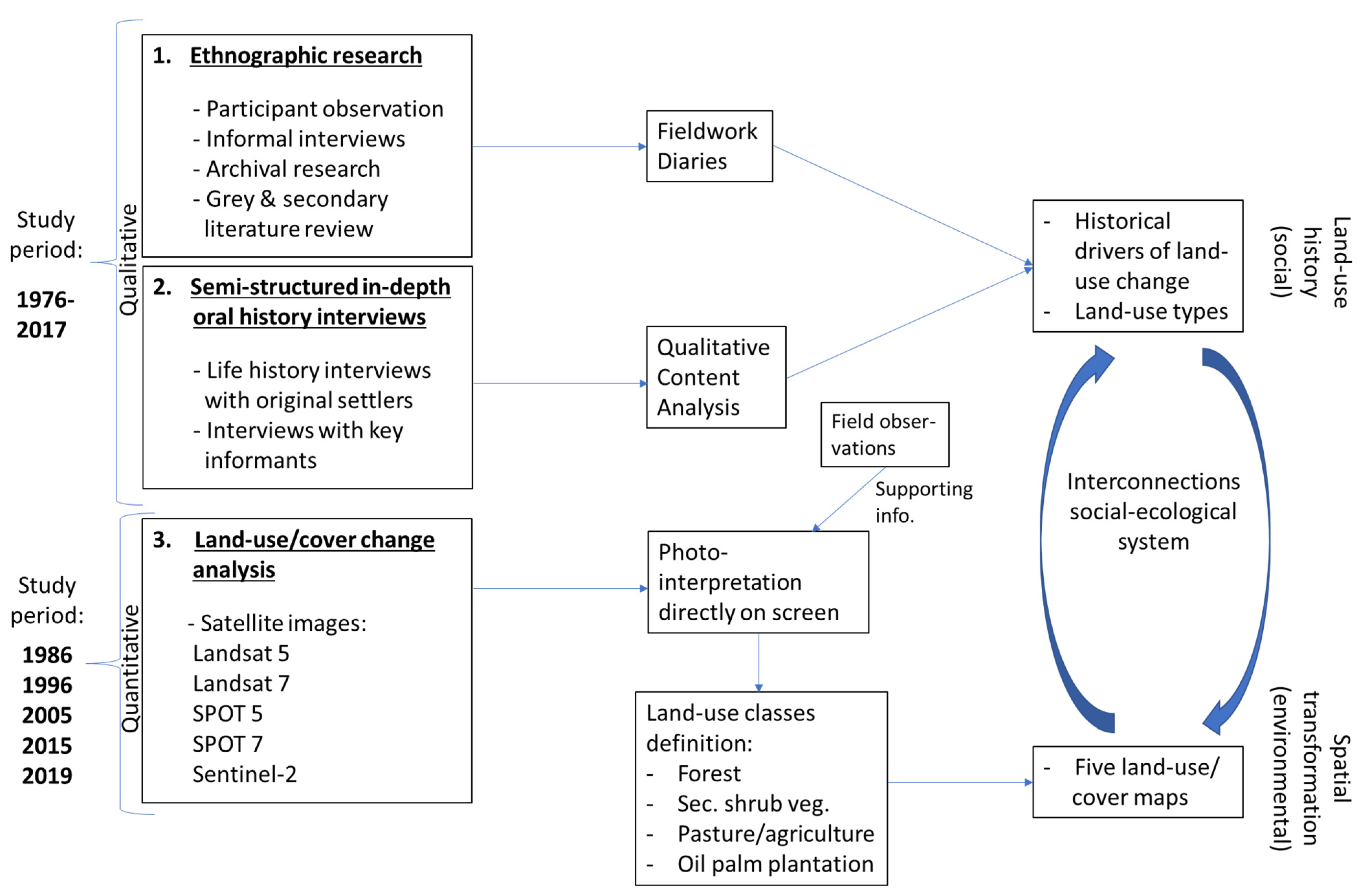
2. Materials and Methods
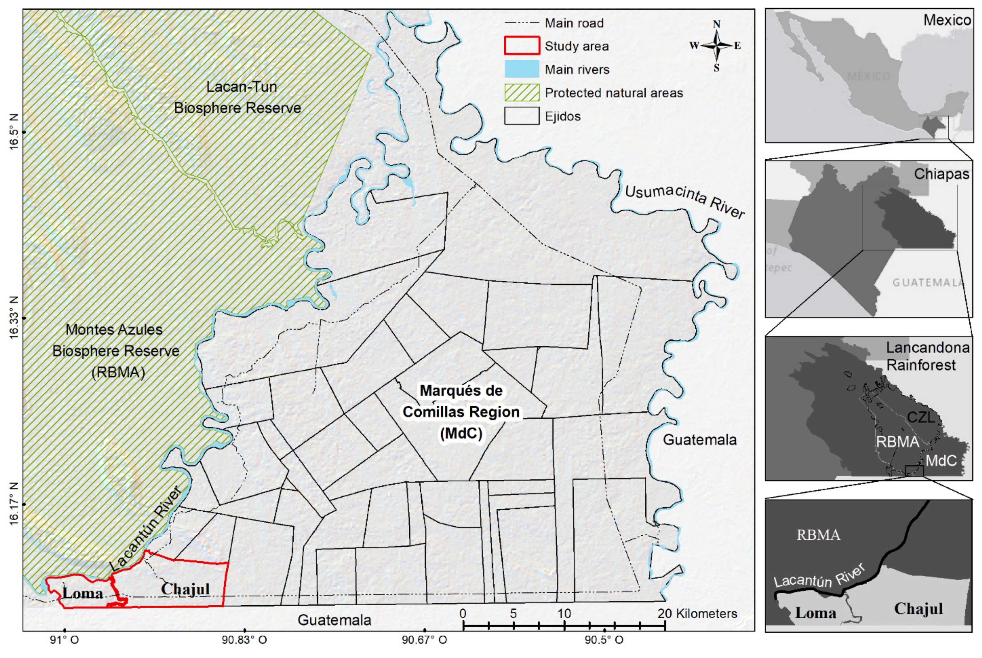
2.1. Study Area

The focus of this study are the neighboring ejidos of Loma Bonita and Boca de Chajul (Loma and Chajul hereafter), chosen for their commonalities as well as their differences in terms of land-use history. These villages are embedded in the southern Lacandona Rainforest in the MdC region, located in the south-eastern corner of the state of Chiapas, bordering Guatemala (Figure 1). The region’s climate is humid tropical with a mean annual precipitation ranging from 2000–3500 mm, and a relatively short dry season from February to March [37]. Compared to other ejidos in the MdC region, Loma is relatively small, with a total area of 1731 ha with the following land-uses: pasturelands, primary and secondary forests, and agriculture. There are no communal use lands. Population is around 164 inhabitants [38], and population density is around 0.09 pers/ha. There are 80 ejidatarios [39]. Livelihood practices are based mainly on self-consumption agriculture, and cattle-ranching is the main economic activity. There are just a few stores in the hamlet where some packaged food items are sold. Compared to Loma, Chajul is a larger ejido, with a total area of 4838 ha with the following land-uses: primary and secondary forests, pasturelands, and agriculture (including commercial crops: oil palm and rubber). Out of the total 4838 ha, 163 ha are communal use lands [40]. Population is 398 inhabitants [38], and population density is around 0.08 pers/ha. There are 145 ejidatarios [39]. Livelihood practices are based on agriculture (mainly for self-consumption but some is sold for cash), and the main economic activities are cattle-ranching, PES payments, some oil palm cultivation, small stores and restaurants, and dump trucks, among others.

2.2. Ethnographic Work

This research is a comparative analysis of two contrasting ejidos based on qualitative (ethnographic research and semi-structured interviews) and quantitative (land-use change spatial analysis) methods (Figure 2). An ethnographic research approach [41] was carried out by the first author for a period of eight months between 2016–2017 (four months in each ejido). Ethnographic methods included participant observation; informal interviews; archival research of the ejidos’ agrarian history (found in the repositories of the National Agrarian Registry—RAN—Spanish acronym), the ejidos’ archives, plus other grey and secondary literature. All data obtained through these methods were carefully recorded in fieldwork diaries. This plethora of ethnographic information was used as a background to contextualize and gain more in-depth understanding of the ejidos landscape/land-use history and livelihoods, to identify original settler families and key actors, and to prepare the (below) survey instrument questionnaire.

2.3. Semi-Structured Interviews

Semi-structured oral history interviews were used as the main qualitative historical data collection method to assess the ejidos’ landscape transformation history from local perceptions, since settlement around 40 years ago. More specifically, a total of 23 semi-structured interviews (20 men and 3 women) consisting of open-ended questions were carried out (see Appendix A for interview guide sample). There were two types of in-depth oral histories interviews: (1) life history interviews with original settlers (10 in Loma and 8 in Chajul) who were mostly elders (men between 61- and 105-years-old, and one 75-years-old woman) but when the original settler had passed away an older son/daughter who was also an original (younger) settler was interviewed; including one Guatemalan ex-refugee who arrived in Loma in 1982 when Guatemala’s civil exploded, and lived there until 1992 when he returned to Cuarto Pueblo, the neighboring Guatemalan village where he came from—the interview was conducted in Loma but he also guided a visit to Cuarto Pueblo. (2) Interviews with local key informants: the ejido council (comisariado, i.e., elected citizen in charge of the ejido; one per ejido), two local NGO personnel, and one researcher who has worked in the study area since 1992. Interviews with original settlers addressed the history of settlement in the study area, and the landscape and land-use changes through time. Interviews with key informants focused on the structure and functioning of each ejido, internal rules on natural resource management, governmental programs, and land-use changes. Interviews were conducted in Spanish, lasted between 1–3 hours, and were recorded with the permission of interviewees. Pseudonyms are used to protect interviewees’ identities. The ejidos’ authorities granted permission to conduct this research. For manual data analysis, the qualitative interview data was first transcribed in Microsoft Word. Then, the qualitative content analysis method [42,43] was applied, which consisted on analyzing the data by coding the interview narratives according to several themes (Table 1). Through this process it was possible to qualitatively reconstruct the landscape transformation history and determine the land-use types that have emerged since the settlement of these ejidos and the historical factors that have influenced these changes. Secondary literature and archival data were reviewed to complement and fill in any gaps in the information obtained through oral histories.

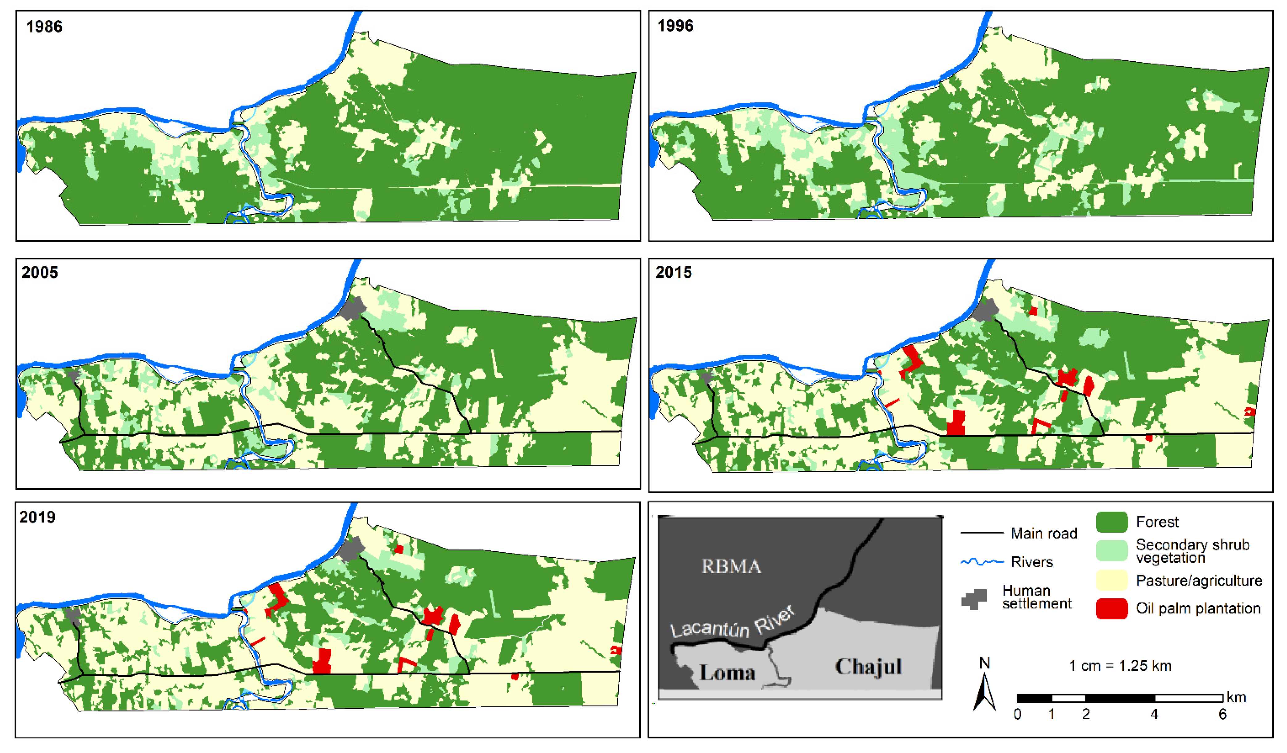
2.4. Land-Use/Cover Change Analysis
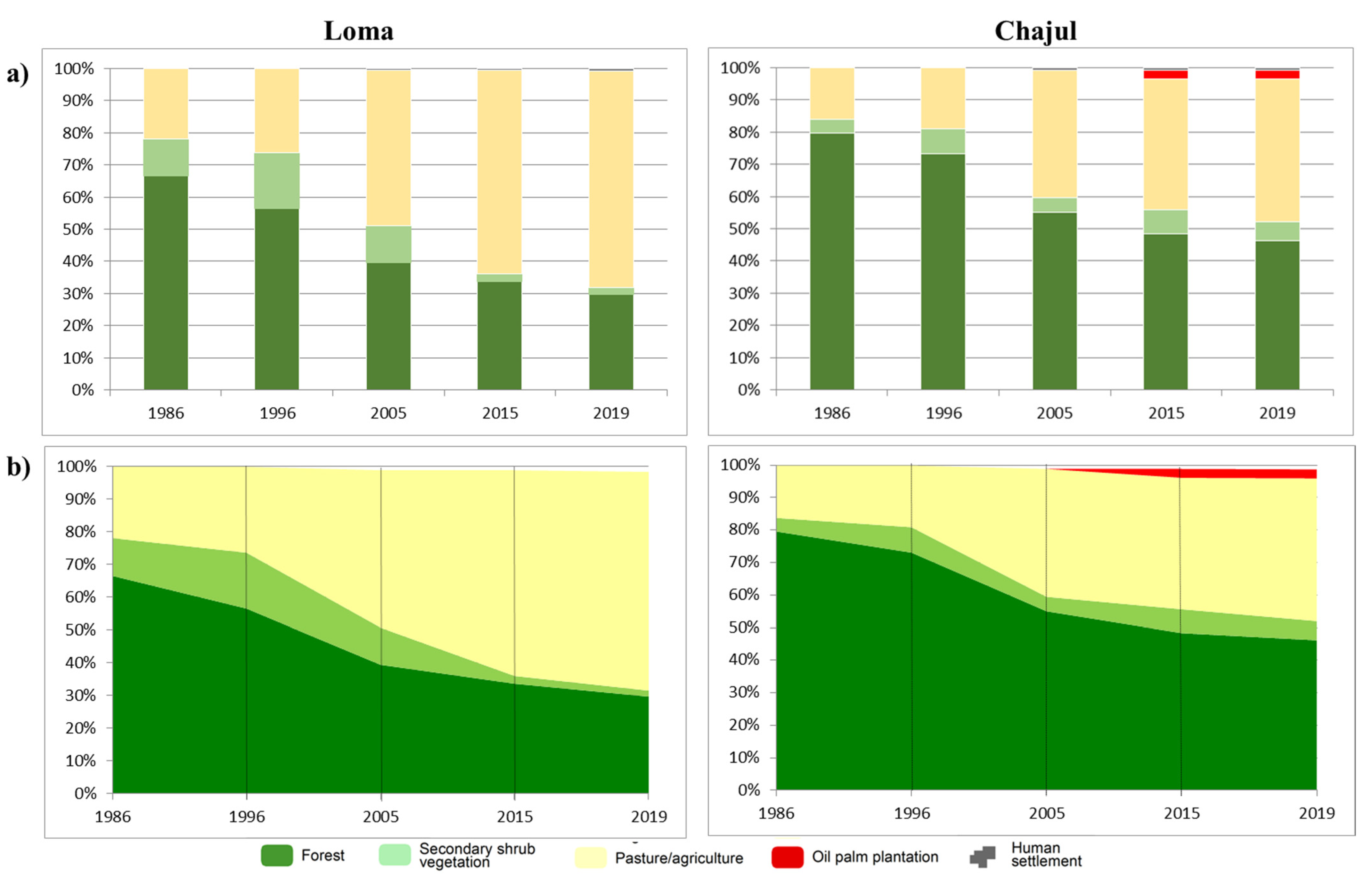
To quantitatively assess the changes in land-use/cover in Loma and Chajul spanning a 30 year approximate period (1986−2019), a land-use/cover change spatial analysis using satellite data was performed. The image analysis was based on cloud-free satellite images from the following time periods and sources: 1986 (Landsat 5), 1996 (Landsat 7), 2005 (SPOT 5), 2015 (SPOT 7), and 2019 (Sentinel-2). Although Loma and Chajul were settled several years before 1986, there were no quality satellite images available prior to that period, therefore the land-use/cover changes from the period the ejidos were colonized up to 1986 could not be estimated quantitatively. For the elaboration of the maps, all the images were photo-interpreted directly on the screen using different band combinations, mainly false color and true color. A set of field observations on the land-uses in the study area taken during the years 1997, 2005, and 2018 were used as supporting information. To avoid over-representation of any land cover class, a system of four land-use classes that were clearly identified in all satellite scenes was defined: forest, secondary shrub vegetation, pasture/agriculture, and oil palm plantation (Table 2). It was decided to group primary and secondary forests in one class (forest) given the difficulty to spectrally separate the successional stage of secondary forests (i.e., young or mature), leading to mature secondary forest to appear as primary forest. As areas devoted to agriculture and pastures are spectrally difficult to separate, especially in the older Landsat images, these were grouped into one class (pasture/agriculture). Rubber plantations were not included in the classification since they were too young to be identified with remote sensing. The methodology to establish the areas affected by the 1998 forest fire is presented in Appendix B. With this remote sensing analysis, the interconnections between the drivers of land-use change that emerged from the oral histories and the quantified temporal landscape changes were unveiled, to be able to reconstruct the land-use history (social) and spatial transformations (environment) of the study area from a social-ecological perspective [44].

3. Results

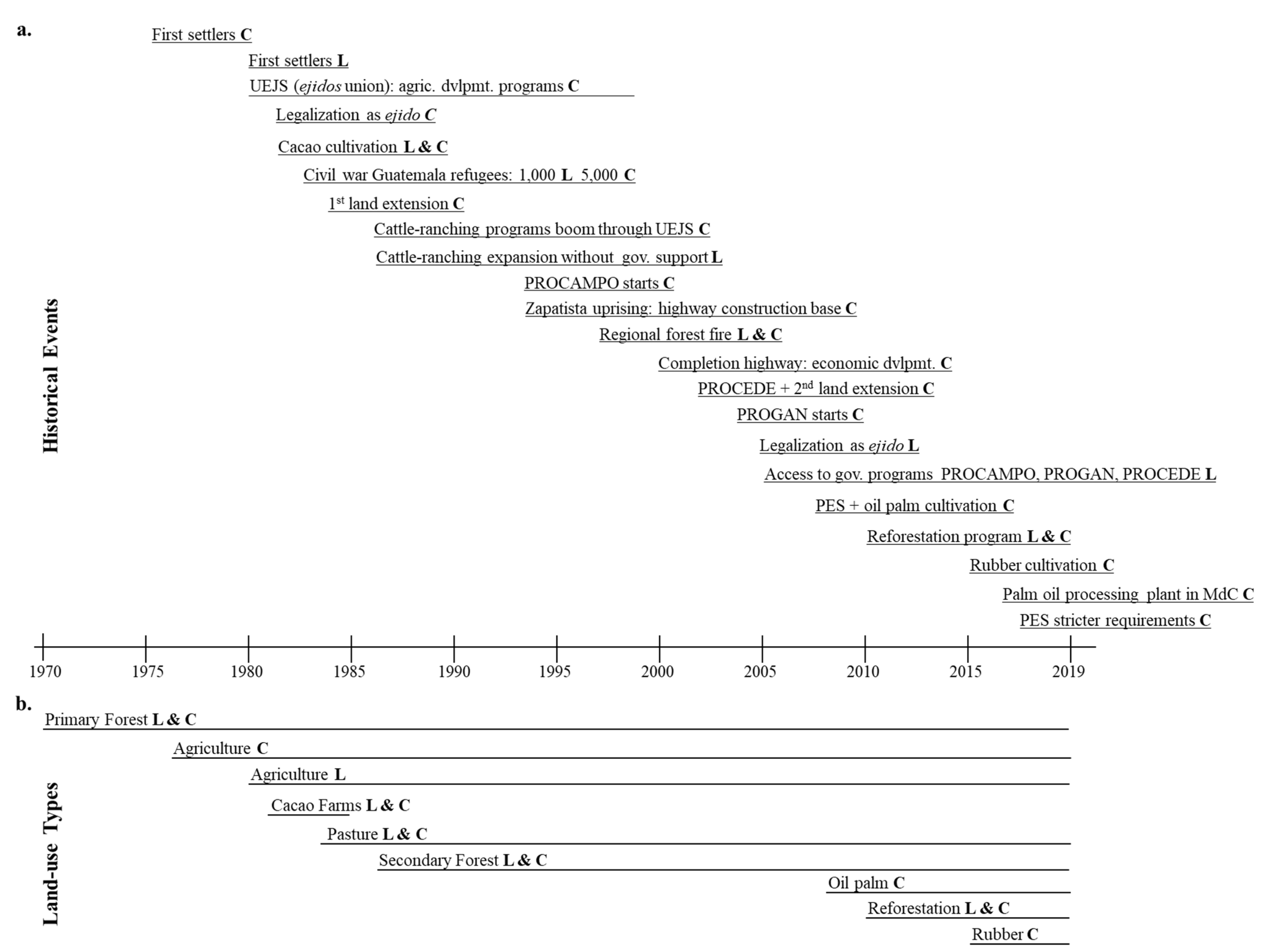
3.1. The Beginnings: 1976–1986

In 1976 the first families, mainly fleeing violence from the state of Guerrero, settled in what it is now known as Chajul. Diego, a 64-years-old first settler remembered: “when I saw the jungle, the land, I was pleased, I said to myself: here I will be able to work [the land] in order to eat, to sustain myself”. Chajul was established officially as an ejido in 1981 with a total area of 1140 ha [45]. By that time, there were still vacant (forested) lands to the east, north and south of Chajul. Thus, Chajul farmers who claimed to have been already exploiting some of those vacant lands, requested and were granted an ampliación (land extension) in 1984, in which Chajul’s size increased to 3810 ha [40]. By this time, since there was much land and not many people, wives and young children were also enlisted as ejidatarios. Therefore, land ownership per household increased from approximately 20 ha to around 30–150 ha, depending on how many ejidatarios were in the household.
The colonization of Loma started at around 1980. The first families to settle there came from northwest Chiapas mainly looking for available lands, as Felipe, a 71-years-old founding settler, remembers about what another Loma settler who arrived before him told him in 1980: “Here there are lands to choose from…and for now they don’t cost you anything, but [the lands] will get fixed up [worked] little by little, and then comes the title, and then [you’re] the owner of the land”. Unknowingly, Loma founders settled in what at that time was CZL territory (see above). This provoked land conflicts with the Lacandón people, which were only resolved until 2005 when Loma became an official ejido. Since early on, Loma occupied an area of 1731 ha and there were 80 ejidatarios (mainly men) requesting land, which meant approximately only 20 ha/household. Loma was constrained by its limits: Chajul to the east, Puerto Rico (ranch) to the west, the Lacantún river to the north, and Guatemala to the south. During the first years of colonization of both ejidos, slowly but gradually the original forested landscape started changing in both villages. On the basis of their ecological knowledge, farmers knew that the riverine soils were in general more fertile, and therefore decided to clear those areas first to cultivate milpa to feed themselves (Figure 3a), as Diego from Chajul reflects: “The main thing we were looking for was food, maize. For maize the only good thing [to grow it] is the riverine areas…where the river reaches to carry water, that is the good land to plant maize, beans, anything”. Each family would clear cut approximately 1 ha per year during the first years following the colonization. Additionally, according to the interviewees many settlers in both ejidos adhered to the cacao agroforestry program (see above; apparently, this was a region wide project promoted in all villages regardless of their official ejido status, like Loma). Farmers planted many cacao hectares under the forest canopy on the first half of the 1980s. However, production was halted mainly by a fungus (that can still be seen in some abandoned cacao farms). Many people converted their cacao fields into pastures, while others abandoned them and are now forest (Figure 3b). Therefore, the land-use types in this initial phase in both ejidos were a similar mosaic of large tracks of primary forest, small areas for milpa agriculture, and forested cacao farms.
The civil war exploded in nearby Guatemala in 1982. An average of 1000 refugees established in Loma and 5000 in Chajul (versus reportedly less than 100 and 300 Mexicans, respectively) between 1982−1984. The Mexican settlers in both ejidos reacted in the same way: they took advantage of the cheap refugees’ labor to quickly convert the forest, first to milpa, so that refugees could feed themselves, and then to pastures, for Mexicans to use for cattle-ranching. Rodrigo, the Guatemalan (ex)refugee that lived in Loma during that time, reflected: “What the Mexicans wanted was for us to cut down the forest. Everywhere where there are pastures now, were the [agricultural] “worked” lands by those who left Guatemala. They [the refugees] worked there to cultivate the milpas, to plant maize”. Refugees cleared the land and were allowed one-year milpa, after which they had to saw grass. For new milpas, refugees were allowed to clear another piece of forested land, under the same conditions, as Marco, an 87-years-old Chajul founder, remembers telling refugees and reflects about that time:
“I’ll give you [land], come…cut [the forest] for you; you will sow [milpa] once, and that’s it, if you want [to cultivate again] you go and cut [the forest] somewhere else; this is how many worked. Those [Mexicans] who were interested in making pastures, used this people [the refugees], who [did it] out of necessity or whatever…”
Another common element related to the refugees’ migration was the cattle they brought from Guatemala to be sold cheaply to Mexicans, given they were desperate for cash. This was one of the ways in which Mexicans acquired cattle in Loma and Chajul to populate the newly opened pastures. Luis, an 88-years-old Loma original settler, mentioned that cows cannot grow under the trees and thus “[one’s] needs makes us to cut [the forest]”. Pastures were opened in areas far from the river, since reportedly those soils are less fertile and not productive for agriculture (Figure 3c). According to the interviewees in both ejidos, during the refugee’s settlement, deforestation was very high, and many forest was converted to pastures, although some of those recently opened pastures areas were not used and the pasture fields converted rapidly back to secondary forest (Figure 3d).

3.2. Agricultural Programs Boom: 1986–1996

According to the interviewees, the legacy of the refugees (i.e., cheap conversion of forest to pastures, and cattle sales) fueled the cattle-ranching expansion in both ejidos (Figure 4), but was further exacerbated for other reasons. Since Chajul was a member of the UEJS union (see above), many farmers took advantage of the cattle-ranching programs launched during the 1980s–90s, to expand pastures and purchase cattle. Paola, a 71-years-old original Chajul settler woman, remembered one of these programs: “When [the government] gave credit, they gave [credit] to my husband. He did [establish] the pasture, circulated [fenced] with wire; they brought the cattle. What I don’t remember is how many cows they gave [us]”. In contrast, since Loma was not an official ejido yet, it could not be part of the UEJS union, and therefore farmers could not access these cattle-ranching projects. Notwithstanding, this did not prevent farmers from expanding the cattle-ranching enterprise, who with own capital and resources cleared more forest for pastures and bought cattle. When asked if having cattle in Loma was people’s own initiative or promoted by the government, Pablo a 57-years-old original settler mentioned: “Initiative of the people. Here the people never had a cattle-ranching governmental project...cattle here has always been from the force [effort] of the people”. For farmers in both ejidos, extensive cattle-ranching was the safer and more profitable economic activity they could pursue. Pablo offers an explanation that largely reflects a general perception about why cattle-ranching expanded in these ejidos and the MdC region:
“Because [here] there is enough water, because cattle take up a lot of water. The land is viable [good] for the grass; the grass grows fast, it doesn’t have problems; and then it is that it [the cattle] had a lot of market, a lot of sales here. They [the buyers] come and take [buy] them small [the calves]…here there are plenty of buyers…they come from Comitán, from Palenque, even from Veracruz. [Cattle] it is what gives the most money to the people [here] in the countryside”.
According to the interviewees, when PROCAMPO (program that incentivizes milpa production) was launched in the MdC region in 1994, many farmers in Chajul entered this program. Since at this point Loma was not an official ejido, it could not benefit from this program. Nevertheless, this did not prevent Loma farmers from cultivating milpa, since this is a staple crop, and with or without government support they produce it for subsistence. During the 1986–1996 period, pasture/agricultural areas and secondary shrub fallow vegetation increased by 9% in Loma and 7% in Chajul, while by 1996 forest cover had decreased to 56% in Loma and 73% in Chajul (Figure 4 and Figure 5).

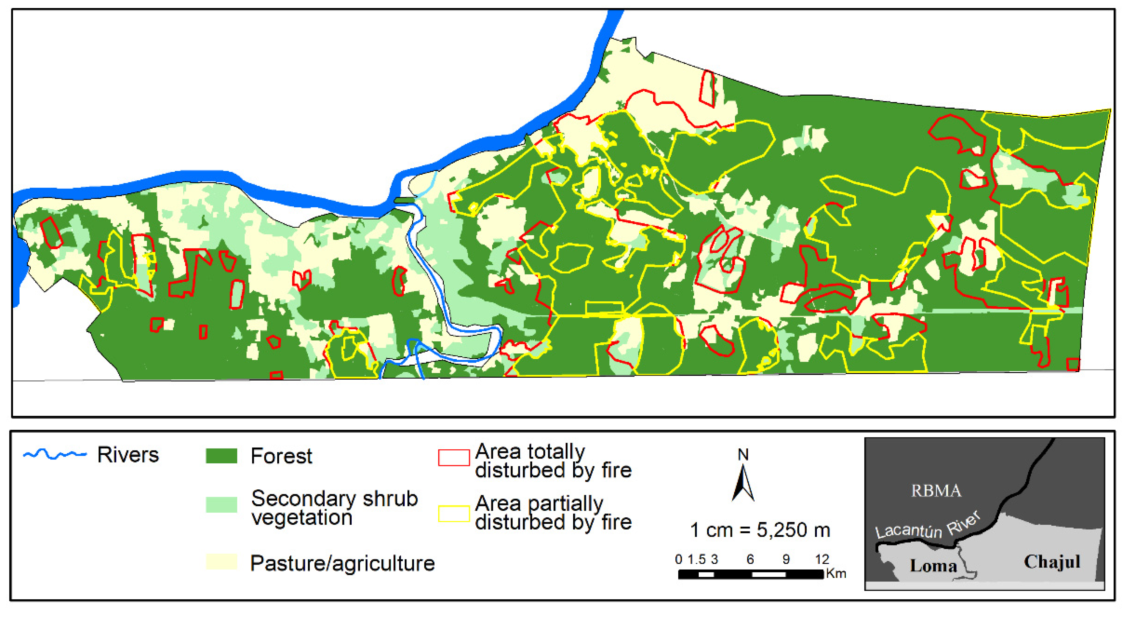
3.3. Fire, Highway, and Legalization of Loma: 1996−2005

According to the ethnographic work, the 1998 regional fire affected Loma and Chajul’s still standing primary forests, where much of the forest was totally burnt (Figure 6). The informants mentioned that in the less affected forests, the fire killed the understory vegetation, but many of the tallest old-growth forest trees survived (these forests today are a mix of secondary vegetation with primary forest trees). The satellite images also revealed that pasture and agricultural lands (including secondary shrub vegetation areas) were affected as well by the fire (Figure 6). The forest clearing provoked by the fire accelerated the conversion of forest to pastures (Figure 4). During the construction of the Southern Border Highway which was completed in 2000, Chajul was an important base for its construction which benefited this ejido economically. For example, Rodolfo, the researcher that has worked in the region since around 1992 remembered: “Like a lot of things concentrated here [in Chajul] when they were constructing the road here, the borderline [highway]…of all the trees they cut down, they put up a sawmill. So, well, a lot of people came to work here”. Besides the sawmill to process wood needed for construction, Chajul farmers were given the opportunity to get dump trucks to carry construction material that converted into a profitable activity that still stands today; others opened small restaurants and convenience stores where construction workers could eat and purchase some goods. In 2002, Chajul adhered to the titling program PROCEDE. Through this program, the communal land exploitation regime was modified, and an individual regime was adopted [40]. By this time, there were still more vacant (forested) lands to the north- and south-east of Chajul. Anecdotally, Chajul farmers had been exploiting some of those vacant lands, and requested these lands to be officially annexed to Chajul. This quadrupled the initial total area of the ejido to 4838 ha. However, since the population had also increased, land ownership per household remained between approximately 30–150 ha. Many Chajul farmers entered the PROGAN cattle-ranching program when it was launched in 2004. Loma finally became an official ejido in 2005, with the same quantity of land (1731 ha), ejidatarios (80), and land ownership per household (20 ha), as in its beginnings. Having clear legal land rights gave eligibility to farmers to access governmental programs, like PROCAMPO, PROGAN, and PROCEDE. Lucas, a 56-years-old Loma founder cites what Mexican President Fox told them in person when Loma was legalized: “It’s not going to be like before, [when] they [the government] closed the doors. Right now, with your papers [land titles] you show up wherever you want, and there you will have your credits [governmental programs] to work [the land]”.
During this 1996–2005 period, pasture/agricultural areas increased while forest decreased in both ejidos (Figure 4). By 2005, 48% and 39% of the surface of Loma and Chajul respectively, were covered with mainly pasture/agriculture fields (Figure 5).

3.4. Conservation Programs and Boom Crops: 2005–2015

By 2005, forest cover in Chajul was still 55% and in Loma only 39% (Figure 5). According to the interviewees, the difference between Chajul and Loma’s forests was that Chajul’s forest was “conserved” and contiguous (Figure 3e). While Loma’s remaining forest was very fragmented (Figure 4) and composed mainly of young acahuales (fallows), and therefore not very well “conserved”. Then, in 2008, the Payment for Environmental Services (PES) program entered the region. Reportedly, to be eligible to enter this program an ejido must had at least 100 ha of compact conserved forest (i.e., primary and/or secondary forest in an advanced successional stage; young secondary forests were not eligible). Therefore, Chajul was able to enroll approximately 2000 ha of conserved forest (both individual and communal lands—approximately 100 ha pertained to the latter type). Ivan, one of the original settlers who owns 60 ha of forested land enrolled in PES, summarizes a generalized view of why in Chajul there was an extensive amount of untouched forest that could be enrolled in PES: (1) households did not have enough resources to exploit the great amount of forested land each family held, thus farmers cleared only the area they needed and were able to work for their livelihoods—this happened because clearing the forest and maintaining the land cleared requires a huge investment of labor, time, and money which households did not have; and (2) there was/is no easy access to the landowners conserved forests (i.e., no roads).
On the other hand, Loma did not meet the eligibility criteria to enter the PES program. For example, there are no communal lands in Loma, and the only existing forest reserve is approximately just 30 ha. Gabriel, one of the NGO personnel and also the son of a Loma founder, explained about trying to enroll Loma in PES back in 2008:
“Myself with another guy, tried to get the amount [of needed forest]. But we only got 120 hectares [of conserved forest], but they weren’t connected. They need to have connectivity…so that…there is connection with the other, and the other, and the other [referring to forest patches]. So…the 120 hectares were [located] some over there, some over here [fragmented forest patches]…so we never made it [to PES]”.
Another difference between the study ejidos is that when oil palm was introduced in the MdC region, some Chajul farmers started adopting this program in 2008 (Figure 3f), while in Loma no one did. For example, Oscar, a 71-years-old Chajul founder, was one on these successful oil palm entrepreneurs. He started planting oil palm in 4 ha (by 2017 he already had 30 ha) in the fertile lands of his agricultural plot next to the river. When asked why he started planting oil palm, he responded: “it is a great business”, because for 75–80 tons harvested, he can earn MXN 180,000 (USD around 9600) every 10 days during the high season (June–November). During the low season, Oscar can earn between MXN 18,000–20,000 (USD around 959–1066) every two weeks, and he adds, “who earns that money every 15 days?”. These are exorbitant amounts compared to what smallholders can earn out of maize/beans and cattle-ranching sales or PES payments in the MdC region. On the contrary, in Loma virtually no one entered the oil palm business because farmers have heard this crop damages the soil permanently, and they are not willing to sacrifice their relatively small plots of land in the long term. Humberto exemplifies a general perception about oil palm in Loma: “In fact I haven’t liked that [oil palm] I know it damages the soil, it impoverishes it. And then the soil is so poor that it no longer produces anything. The roots enclose the ground…and they don’t leave space [for anything else to grow]”. Humberto adds: “but the good thing is that people have not wanted [it]”, referring to the fact that Loma farmers have not accepted the governmental offers to enter this program. Camilo from Loma says that whoever plants oil palm will damage their land, because they have seen it in other regions: “we realize the soil looks ugly; everything is dry. That is not convenient, it would be absurd [to plant oil palm]”.
From 2010 onwards, some farmers in Loma and Chajul adopted the reforestation program (Figure 3g). Gabriel, the NGO technician from Loma, mentioned that the project’s goal was to reforest 400 ha in the region with commercially valuable native tree species like mahogany (Swietenia) and cedar (Cedrela). The project aimed at working with cattle-ranchers to restore (parts) of their pastures. According to Gabriel, 550 ha were reforested in the region, exceeding the original goal. Starting around 2015, a handful of Chajul smallholders engaged in rubber cultivation (Figure 3h). Mauricio is one of those rubber pioneers. He said he got into the rubber program because he has friends in other ejidos in MdC, who have had profitable rubber plantations for years. In his own words: “There are many friends that I have who have been huleros [owners of rubber plantations] for many years. It [the rubber] is scratched [extracted] every third day…It’s [it takes] seven years, for the trunk to get thick [enough to produce latex]”. The ethnographic work showed that in Loma, in contrast to Chajul, there has not been much interest in cultivating rubber, and therefore no one has planted this crop there. Unlike oil palm, the little interest comes, not so much because farmers have a negative perception about rubber, but because it takes many years for there to be latex production.
During the period 2006–2015 forest conversion to mainly pasture areas continued in Loma with a 15% increase, while forest decreased by 5% (Figure 4 and Figure 5). In contrast in Chajul, there was only a slight increase (1%) in pasture/agricultural land, while forest decreased by 8%. Oil palm (occupying 3%; Figure 4 and Figure 5) and rubber (just a few plantations although cover percentage unknown) emerged during this period in Chajul.

3.5. The Recent: 2015–2019

For this period the landscape of the studied ejidos remained somewhat the same, although a slight forest loss is perceived (Figure 4). During fieldwork, informants mentioned that the PES program was implementing stricter requirements for enrolled landowners. Chajul interviewees were not happy with these changes. Reportedly, the PES was requiring that 50% of the payment farmers receive, to be re-invested in conservation efforts in the enrolled forested lands. In addition, there were rumors about a substantial decrease in the amount of PES annual payments. Many farmers were having doubts on whether renewing their 5-year PES contracts or not. For example, Diego from Chajul who has around 30 ha enrolled in PES, expressed: “So what’s the use of having it [the forest]? If I came here [to Chajul] for the land to sustain me. [So] if they [PES program] are going to start to put obstacles, then they can go, they can go [referring to the PES program]”. Despite of this, forest in Chajul remained relatively the same during this period (Figure 4 and Figure 5). Regarding oil palm, informants mentioned that originally, there was only one palm oil mill in southeast Chiapas, located in the city of Palenque, but in 2016 one more opened in MdC closer to Chajul. Reportedly, since the second company opened, oil palm price has gone higher because of the competition. In addition, each company competes to provide more services to the farmers, like technical assistance and the pick-up service of the produce, to try and get the farmers to choose the company that offers more benefits. Nevertheless, between 2015–2019, oil palm plantations remained relatively the same in Chajul (Figure 4 and Figure 5).
In contrast, Loma’s relatively small total area and only around 20 ha/household, conserving part of the forest was not possible, because farmers practice extensive cattle ranching (which is the common practice in the region, since reportedly soil quality is not good enough to intensify). Loma farmers could not make the choice of leaving forested areas, but had to convert the majority of their plots to pastures to be able to fit enough cattle to make a living. In the own words of Loma’s ejido council:
“Everyone has their own plot where they work, and if I plant trees on this land [plot], where am I going to saw my milpa? Well, there is no [space] where [to plant corn]. Because here most people dedicated to cattle-ranching, they made pastures; they just left a piece of land where they will grow their milpa. And if you plant a lot of trees in your pasture, the grass will no longer grow”.
During this 2015–2019 period, there was a slight 4% increase in pasture/agricultural areas in Loma and Chajul. Regarding the forest cover, there was a 4% decrease in Loma, and only 2% decrease in Chajul (Figure 4 and Figure 5).

3.6. Synthesis: Historical Events and Land-Use Types

Loma and Chajul differential histories and specific drivers of land-use change (Figure 7a) have influenced the emergence of different land-use types through time in these ejidos (Figure 7b). Although there are only four land-use classes used in the land-use/change analysis (forest, secondary shrub vegetation, pasture/agriculture, and oil palm), the results from the oral histories show that within these classes, there have been specific land-use types: primary forest, milpa agriculture, fallows (secondary shrub vegetation), cacao farms, pasture, secondary forest (acahual), and reforestation. In addition, there is oil palm and rubber which are land-use types found only in Chajul, making this a more diversified ejido than Loma.

4. Discussion

By linking together the oral histories and the land-use/cover analysis, the historical social-ecological processes that changed the original forested landscape in the two studied ejidos were demonstrated, along with the different land-use types that emerged through time as a result of these processes, producing different land-use mosaics in Loma and Chajul, in a 43-year period from 1976–2019. As was illustrated through this case study, the combination of local, regional, and national processes and factors are important determinants of land-use change in the forested tropics [3,47]. Cano Castellanos’ [28] research in other ejidos in the MdC region, also concluded that the specificity in landscape change has been due to the distinct historical context in which each of those ejidos developed, with their unique and intricate social, political, economic and ecological factors and interactions. The most significant drivers of land-use change in Loma and Chajul have been related to different social-ecological factors, which have been varied and contingent to historical—and many times aleatory—processes. These factors have not worked in isolation, but have interacted in intricate forms to give way to the different land-use compositions and landscape mosaics in these villages. The results will now be discussed in relation to the land-use change in the regional context, and to the implications of land-use and tenure history in rural livelihoods.

4.1. Local Land-use Change in the Regional Context

For the end of the period 1976–1996, De Jong et al. [48] reported that forest cover in the MdC region was reduced to 73%, pasture areas increased to 15%, and secondary shrubs to 10%, while cultivated land only covered 1%. In line with these regional trends, results show that for this period there was a dramatic forest conversion to pastures for cattle-ranching in the study site (although forest cover in Loma was much lower (56%) compared to that of MdC and Chajul; Figure 4 and Figure 5). De Jong et al. argue that land-use change patterns in the 1970s–1980s in the MdC region were due to (dirt) road construction and oil exploration which stimulated rapid colonization. In this article it is contended that the most important event that ignited the landscape transformation process in the MdC region was the governmental declaration of the southern Lacandona Rainforest as national lands apt for colonization. Bray and Klepeis [49] agree that for the forests of southeastern Mexico, including the Lacandona Rainforest, spontaneous and government-led colonization has been the most important driver of forest conversion in their recent history. Back in the 1960s, colonization programs of forested areas occurred not only in Mexico but in many other Latin American countries, mainly to avoid the establishment of armed rebel groups on remote forested areas, which was occurring already in many nations [47]. De Jong et al. [48] believe land-use subsidies during the 1980s–1990s triggered the increase in pastures in the MdC region. Similarly, it is shown here, this was true for Chajul, but not for Loma. Pasture conversion and cattle-ranching in Loma was undertaken without any subsidies, given that Loma farmers during those decades were land-tenure insecure, did not held land-titles and therefore could not access government support.
For the end of the period 1997–2005, Castillo-Santiago [50] found that forest cover in the MdC region had been reduced to 45%, pasture areas increased dramatically to 28%, cultivated area to 12%, and secondary shrub vegetation to 13%. This research’s results are similar to these regional trends in both studied ejidos for this period: less forest, and mainly more pasture (Figure 4; agricultural areas for subsistence production occupy much less area than pasture). Castillo-Santiago discussed that land-use change during this period in the region was triggered by the demand for land for extensive cattle production, and to a lesser extent for agricultural production; an argument fully supported by this study findings for Loma and Chajul. For the period 2003–2007, Meli et al. [51] showed a high deforestation rate (5.6%) in MdC, which they associated with program subsidies for cattle-ranching and agriculture. This may hold true for both studied ejidos, since by 2005 Loma was an official ejido, and consequently smallholders finally had access to rural development governmental programs, like PROCAMPO, PROGAN, and PROCEDE. Such programs were the result of larger structural forces linked to neoliberal free-market policies that supported land privatization and liberalization of the agricultural sector, especially after the NAFTA (North American Free Trade Agreement) took effect in 1994 [52,53,54,55]. The bordering rainforest region of Ixcán in Guatemala, registered high forest conversion rates to cattle pasture by smallholders during the 1990s through mid-2000s [56]. In contrast to Loma and Chajul, cattle-ranching in Ixcán was driven by remittances, because access to credit for farmers was very limited. In a wider context, the Peruvian Amazon reported a high deforestation rate (15%) for the period 1993–2005 [57]. According to Arce-Nazario [57], forest conversion in the Peruvian Amazon was related to a high peak in agricultural credits to smallholders in the late 1980s, which unlike the MdC region, were not for cattle-ranching but to farm crops, demonstrating that drivers of land-use change and resulting landscape trajectories can differ across tropical forested regions.
Castillo-Santiago [50] also argues that the completion of the border highway in 2000, contributed to the high deforestation rate in MdC during the 1997–2005 period. It is illustrated that for Chajul, the construction of the highway contributed to the economic development of this ejido, but not true for Loma, which did not receive direct economic benefits during its construction. However, having access to the highway has provided many benefits (e.g., access to markets) to Loma and Chajul and to all ejidos in the region. As for natural disturbances, the most important one during the recent history of the study site and the MdC region was the 1998 forest fire. The 1997–1998 El Niño event provoked a very extreme drought in 1998. This El Niño event caused losses estimated at USD 2 billion in the Mexican economy, as well as forest fires and losses in agriculture and fisheries around Mexico [58]. Lohbeck et al. [59] demonstrated a remarkable peak in forest cover loss in MdC due to the 1998 extreme drought—a four-fold increase in forest disturbance compared to other years in the period 1991–2016. In line with this study findings, Lohbeck et al. argue that MdC farmers took advantage of the extensive forest clearance provoked by the fire for massive pasture conversion. Tropical forests elsewhere, for example in the Amazon and southeast Asia, were also severely affected by wildfires associated with the extensive droughts caused by this El Niño event [60,61].

4.2. Livelihood Portfolios

In the results, the histories of Loma and Chajul were compared in terms of land-tenure and land-use. Their differential histories have not only had an impact on land-use change decisions but also on the particularities of each ejido’s livelihoods. Land tenure conflicts between the Lacandón peoples and at least 43 irregular settlements within the Comunidad Zona Lacandona, left settlers without legal land-rights for a prolonged period of time [62]; 25 years in Loma’s case. This land-tenure insecurity excluded Loma settlers from having equal access to governmental development opportunities as Chajul did since the beginning (e.g., being part of the UEJS or the dump-truck union). This triggered Loma livelihoods to be highly reliant on the land—especially on cattle-ranching which is Loma’s fundamental livelihood strategy—a result corroborated by de Vries [63]. Since Loma did not have surrounding available land were to expand, it remained a relatively small ejido with less land per household and no communal lands, as compared to Chajul. Cattle-ranching remains one of the most widespread economic activities and the most common land-use in MdC, mainly because: (1) it is practiced extensively due to low soil productivity, (2) relatively low levels of needed investment, (3) stable national market for livestock, and (4) continued (economic) State incentives for cattle production [33,64]. Since Loma farms are just around 20 ha, this meant that in order to fit enough cows to make a living (approximately 2 cattle/ha), Loma farmers had to convert the majority of their farms to pasture. Leaving little room for diversifying their land-use portfolios (just a few hectares for subsistence agriculture and some spare forest). Outside cattle-ranching, there are not many more economic activities in Loma, other than a handful of small convenience stores. In addition, Loma farmers do not receive the PES subsidy since they do not qualify to enroll on this conservation program. Due to the bad reputation oil palm has among Loma farmers, they do not want to engage in its cultivation. Finally, planting rubber has not been very appealing for Loma smallholders, since unlike cattle that can be sold very quickly to obtain cash, the time investment in rubber before it can produce latex is too long to meet needed immediate cash returns.
In contrast, Chajul did not have any land conflicts, thus was able to secure its official status as ejido since early on, access development programs and seize other economic opportunities that allowed some capital accumulation. Chajul also had the advantage of having available lands where to expand, which allowed space for communal lands and households to own larger farms (around 30–150 ha). Presumably, larger plots meant having more land to diversify land-use decisions. Actually, according to Rodríguez Silva [65], Chajul is one of the more diversified ejidos in MdC in terms of land-use types. Chajul’s history has allowed farmers to diversify their livelihoods portfolios and to be less reliant on the land when compared to Loma. For example, besides dedicating to agricultural practices, many Chajul smallholders earn off-farm income from different activities: carpentry, school teachers, bike and auto-repair services, among others. Similarly, livelihood and land-use diversification were demonstrated in East Central Mexico, where diverse landscape mosaics and livelihood strategies were historically mediated by different rural development policies, access to land and changing markets, among other factors [66].
In addition, Chajul farmers enrolled in PES have received these payments for more than 10 years, and some of them have invested the money in off-farm activities (e.g., opening small restaurants, stores, or lodgings) or in sending children to school; investments that have helped them diversify their livelihood portfolios. Whether PES actually improves local livelihoods remains unclear, although it has been argued that its success depends on how each PES scheme is designed for each local context, as has happened in the Brazilian Amazon [67], and elsewhere in the tropics, including MdC neighboring Maya Biosphere Reserve in Guatemala [68]. It is argued that profits from PES have helped to improve livelihoods in Chajul, although smallholder willingness to remain in PES can be temporary, especially when the requirements change in detriment of farmers profits. In MdC, farmers constantly re-examine their livelihood conditions, and remaining in PES will depend on the individual farmers’ decisions about which better economic opportunities alternative land-uses might bring [65,69].
Although as mentioned before, cattle-ranching is the main economic activity in MdC, cheaper prices of cattle smuggled to the region from Central America have made some local producers to consider economic alternatives [30], like some Chajul farmers. Apparently, having large farms has enabled these smallholders to experiment and diversify their land-uses portfolios without having to choose one use over the other. Castellanos-Navarrete et al. [70] show evidence that oil palm supports rural livelihoods in Latin America, including Mexico (Chiapas) when land access and smallholders are supported by policies as is the case in MdC. Nevertheless, smallholder profits are highly contingent on palm oil fluctuating prices, which threatens the livelihoods of oil palm farmers [70]. Lastly, a few Chajul pioneer smallholders have recently engaged in rubber production. Since these farmers have large farms and can subsist out of other land-use practices and off-farm incomes, they can afford to wait the 7–8 years it takes for latex to be produced, and be able to make a profit out of rubber plantations in the long-term. Similarly to Chajul, Christman et al. [71] reported livelihood atomization processes in the north-east Lacandona Rainforest, where landholders with larger land-holdings and more resources had greater opportunities for agricultural diversification (e.g., adopting tree plantations like rubber and oil palm). In contrast, these authors argue that farmers with smaller farms were constrained by the amount of land to practice just a few land-use strategies (i.e., subsistence milpa and/or cattle raising), like in Loma.

5. Conclusions

This comparative case study provided empirical evidence of a plethora of human-environment factors that have interacted across different spatial and temporal scales, and led to the conversion of an originally forested landscape to a dynamic and complex agroforest frontier in the last 40 years in tropical Mexico. The findings illustrate how forest conversion and land-use change in the study area has been the result of historical factors involving complex social, political, institutional, economic and ecological processes, such as: a colonization program, soil quality, land-tenure security, land conflicts with the Lacandón indigenous people, availability of surrounding land where to expand and land extensions, an ejidos’ union, the civil war in Guatemala, several agricultural development programs, the Zapatista uprising, a regional wildfire, the construction of the highway, and forest conservation programs, among other factors. The differential land-use and land-tenure histories of these two neighboring villages have led to distinct landscape mosaics: the smaller ejido, Loma, is characterized by a dominating pasture landscape with some scattered agricultural and forest areas, while the larger ejido, Chajul, has large conserved forest areas intermixed with pastures, agriculture, and oil palm and rubber plantations. These land-use mosaics have also had implications for the livelihood portfolios in each ejido: Chajul being more diversified compared to Loma. Fine-tuned understanding of site-specific and micro-level variations in land-use change can lead to effective forest conservation policies and strategies [72]. A landscape mosaic that includes both productive and less productive land-uses that are compatible with and can improve farmers’ livelihoods (multi-functional landscapes, e.g., Mastrangelo et al. [73]) should be the target of land-use policy interventions and forest conservation strategies.

Author Contributions

Conceptualization, C.B., G.V., E.G.-F. and F.B.; data curation, C.B.; formal analysis, C.B. and E.M.-V.; funding acquisition, F.B.; investigation, C.B.; methodology, C.B., G.V., E.G.-F., E.M.-V. and F.B.; project administration, F.B.; resources, E.G.-F. and F.B.; supervision, G.V., E.G.-F. and F.B.; validation, C.B., G.V., E.G.-F. and F.B.; visualization, C.B.; writing original draft, C.B.; writing—review and editing, C.B., G.V., E.G.-F., E.M.-V. and F.B. All authors have read and agreed to the published version of the manuscript.

Funding

This research was funded by the FOREFRONT programme (5160957104 INREF-FOREFRONT) through the Interdisciplinary Research and Education Fund (INREF) of Wageningen University. E.M.-V. was supported by Forests 2020 project financed by the United Kingdom Space Agency (UKSA).

Data Availability Statement

The data presented in this study are available on request from the corresponding author. The data are not publicly available due to privacy issues.

Acknowledgments

We are thankful to the ejidos of Loma Bonita and Boca de Chajul for allowing this research, and to all the interviewees that patiently took the time to share their detailed life histories. Special thanks to the Departamento de Estudios y Observación de la Tierra, la Atmósfera y el Océano (TAO), El Colegio de la Frontera Sur (ECOSUR), Unidad San Cristóbal de las Casas, Chiapas, where Miguel Angel Castillo kindly provided access to the information used to elaborate the land-use classification maps, and to Emanuel Valencia for an earlier version of the land-use change maps. Thanks to Cecilia Moreno for translating the interview guide in Appendix A into English.

Conflicts of Interest

The authors declare no conflict of interest. The funders had no role in the design of the study; in the collection, analyses, or interpretation of data; in the writing of the manuscript, or in the decision to publish the results.

Appendix A

Oral History Interview Guide about the History of Colonization

Personal Data:

  • Full name
  • Age

Before Arriving to Loma/Chajul:

  • Where were you born? Where did you grow up?
  • Where did you live prior to coming here and how long did you live there?
  • How did you make a living there: agriculture, raising cattle? What benefits (self-provisioning/cash) did you derive from that/those activity/activities? Did you work for someone else?
  • How was the landscape where you used to live? Was it a jungle/forest like here? Was it a desert? Was it mostly pastures? Mostly agricultural plots? Did you like it there where you lived? Why?

Colonization Loma/Chajul:

  • What year did you come here?
  • What did you think when you came here and saw that it was all jungle? Did you wish to go back?
  • How old were you when you came here and who did you come with (parents, siblings, spouse, children, friends?)
  • Why did you come? Did the government give you that option? Why did you end up here and not somewhere else?
  • How did you come here (boat, walking, small plane) and how long did it take you to get here?
  • What did you find here when you arrive, forest? Where there more people already here?
  • What did you start doing when you got here? Cut down the forest? Why? Was that your own initiative or did somebody else tell you to do it (e.g., the government)?
  • Did you cut down the forest with more people? How did you organize to do it? How did you do the forest? What tools did you use and where did you get them from?
  • How long did it take you to cut down the forest?
  • What did you live out of while you were cutting the forest? From where did you get food to sustain yourselves?
  • Once you clear-cut the forest what did you start doing? What was the purpose of cutting down the forest? What did you want to transform the forest into?
  • Did you cut down all the forest of the ejido or just where the town was going to be?
  • What animals were there at the beginning? Did you kill them? If so, for food or to defend/protect yourselves?
  • What did the government say to you (during this time)? Did the government send somebody to give you information? If so, how often?
  • What was the process for legalizing the land? How was it divided? Between how many people? In what year?
  • Are you an ejidatario? Your wife is ejidataria? Do you have a solar? Do you have a parcela (farm-plot)? If so, how many hectares is your parcela? Do all ejidatarios have same size parcelas? Who decided the size of the parcelas? And, who decided their location?
  • Did you (the community) leave any forest in the ejido initially? Why and what for?

Years following the Colonization Loma/Chajul:

  • Did more people start coming after the first families settled here? In what years? Why? Do you know where they came from? Were they able to become ejidatarios?
  • What were the first agricultural activities you started doing after cutting down the forest? Milpa? And the other families? Did you do it for subsistence? Did you sell something of what you produced?
  • According to your knowledge, what agricultural activity is the soil of Loma/Chajul good for? To grow crops, which? For pasture for cattle-ranching?
  • Is the soil quality of Loma/Chajul the same in the entire ejido? Or, how is the soil quality distributed in the ejido? Is the soil more fertile near the river? Less fertile the farther it is from the river?
  • Has the quality of the soil been the same since you came here? Or, has it decreased?
  • What else have you grown other than the maize: beans, pumpkin, chili peppers? Fruits: which ones?
  • When was cattle introduced to Loma/Chajul? Why? Was it the people’s own initiative to raise cattle? Or cattle raising was part of a government program?
  • Do you also have pasture for cattle raising in your parcela? Do you have cattle? If so, how many heads of cattle do you have? Is it beef or dairy cattle?
  • When did you start raising cattle? Where did you get the resources to buy cattle?
  • Do you like raising cattle? Has it helped you economically to survive?
  • Do you think that cattle-ranching has improved your family’s life in any way? Do you think that your life and your family’s life would have been different if you had not had cattle?
  • What other crops have you had other than maize? Cacao, coffee, rice, rubber, oil palm? Why did you plant that/those crops? What was the purpose?
  • Planting that/those crops was it your own initiative? Or, was it a program from the government or any other organization; if so, which one? What was the program about? What happened with that/those crops? What happened with the program/s?
  • What other programs there have been in Loma/Chajul? When? Have you benefited from them? Who brought them (the government, NGO, etc.)?
  • Do you have in your parcela any part that is still forest, meaning that you have never cut it down since you came, or that you cut down at some point but after you used it you left it as acahual (secondary forest)? If the latter, how old is that acahual? Why do you have that forest reserve/acahual? Do you have that forest reserved for something? Or, would you like to leave it as a forest forever?
  • What do you think about the forest? Do you like it? What is your relationship with it? Does it have any meaning for you?
  • Would you like that there was more forest like before? Or, would you prefer for all the forest to be cut down and replace it with something else? Is the forest useful to you? Do you get any benefits from it? If so, which ones?
  • Does Loma/Chajul currently have a forest area that is a community reserve? If so, do you know how many hectares it is? What do you think about that area? Does it make any sense to have that forest there without cutting it? Or, do you think that it would be more beneficial if the forest reserve was turned into more parcelas for growing crops or pasture for cattle?
  • Have there been any forest restoration/conservation programs in Loma/Chajul? If yes, who has brought those programs, why and when? What has happened with that/those program/s? Do you think people in the ejido do not want the forest? Do they prefer agriculture or cattle?
  • Do you think that the way you lived in (place of origin) and the agricultural activities you practiced there have had any influence on the agricultural/cattle activities that you have performed here in Loma/Chajul during all these years since you got here? Why? How?
  • Do you think that Loma/Chajul has changed a lot since you came here for the first time? Has the landscape changed for better or for worse? Do you like it better the way it looks now or the way it looked back when you first arrived? Or, when did you like it more, when the landscape looked how?

Appendix B

Methodology to Establish the Areas Affected by the 1998 Fire in the Study Area

Cloud-free satellite images (Landsat 5) for the months of April, May, and June 1998 were used to establish the forest and pasture/agriculture lands affected by the 1998 fire, showing recently burnt areas during that period (Figure 6). The areas identified as affected by the fire were overlaid on the 1996 land-use cover map to show both the forested areas and pasture/agriculture lands that were totally or partially disturbed during the severe wildfire. Totally disturbed areas refer to forest and pasture/agriculture lands where the vegetation was completely burned; while partially disturbed areas refer to forested areas that were mostly burned at the understory level, while the arboreal vegetation was not severely affected and a good part of the canopy was not burned.

Notes

1
One of the principal forms of land tenure in Mexico that consists of communal land rights by a group of people who manage the use of the land and natural resources collectively; see [34].

References

  1. Winkler, K.; Fuchs, R.; Rounsevell, M.; Herold, M. Global Land Use Changes Are Four Times Greater than Previously Estimated. Nat. Commun. 2021, 12, 2501. [Google Scholar] [CrossRef]
  2. IPBES. Global Assessment Report on Biodiversity and Ecosystem Services of the Intergovernmental Science-Policy Platform on Biodiversity and Ecosystem Services; IPBES Secretariat: Bonn, Germany, 2019. [Google Scholar]
  3. Magliocca, N.R.; Rudel, T.K.; Verburg, P.H.; McConnell, W.J.; Mertz, O.; Gerstner, K.; Heinimann, A.; Ellis, E.C. Synthesis in Land Change Science: Methodological Patterns, Challenges, and Guidelines. Reg. Env. Chang. 2015, 15, 211–226. [Google Scholar] [CrossRef] [PubMed] [Green Version]
  4. Meyfroidt, P.; Roy Chowdhury, R.; de Bremond, A.; Ellis, E.C.; Erb, K.-H.; Filatova, T.; Garrett, R.D.; Grove, J.M.; Heinimann, A.; Kuemmerle, T.; et al. Middle-Range Theories of Land System Change. Glob. Environ. Chang. 2018, 53, 52–67. [Google Scholar] [CrossRef]
  5. Agnoletti, M.; Neri Serneri, S. The Basic Environmental History; Environmental History; Springer International Publishing: Cham, Switzerland, 2014; Volume 4. [Google Scholar] [CrossRef] [Green Version]
  6. Gregory, D.; Johnston, R.; Pratt, G.; Watts, M.J.; Whatmore, S. The Dictionary of Human Geography, 5th ed.; Wiley-Blackwell: Oxford, UK, 2009. [Google Scholar]
  7. Cronon, W. The Uses of Environmental History. Environ. Hist. Rev. 1993, 17, 1–22. [Google Scholar] [CrossRef] [Green Version]
  8. Gallini, S.; de la Rosa, S.; Abello, R. Historia Ambiental. In Hojas de Ruta. Guías para el Estudio Socioecológico de la Alta Montaña en Colombia; Ungar, P., Ed.; Instituto de Investigación de Recursos Biológicos Alexander von Humboldt: Bogotá, Colombia, 2015; pp. 1–72. [Google Scholar]
  9. Urquijo, P.S.; Vieyra, A.; Bocco, G. Geografía e Historia Ambiental; Centro de Investigaciones en Geografía Ambiental UNAM: Morelia, Mexico, 2017. [Google Scholar]
  10. García, B. Percepciones Locales de Los Cambios de Usos Del Suelo: Un Ejemplo En La Reserva de La Biosfera La Encrucijada, Chiapas. In Geografía e Historia Ambiental; Urquijo, P.S., Vieyra, A., Bocco, G., Eds.; Centro de Investigaciones en Geografía Ambiental UNAM: Morelia, Mexico, 2017; pp. 140–172. [Google Scholar]
  11. Lambin, E.F.; Geist, H.J. Land-Use and Land-Cover Change: Local Processes and Global Impacts; Springer Science & Business Media: Berlin/Heidelberg, Germany, 2008. [Google Scholar]
  12. Klepeis, P.; Turner, B. Integrated Land History and Global Change Science. Land Use Policy 2001, 18, 27–39. [Google Scholar] [CrossRef]
  13. Williams, B.; Riley, M. The Challenge of Oral History to Environmental History. Environ. Hist. Camb. 2020, 26, 207–231. [Google Scholar] [CrossRef]
  14. Tauro, A.; Guevara, S. Historias Para Escuchar y Diversidad Que Cuidar. Cuad. Biodivers. 2009, 29, 14–19. [Google Scholar] [CrossRef] [Green Version]
  15. Arce-Nazario, J.A. Landscape Images in Amazonian Narrative: The Role of Oral History in Environmental Research. Conserv. Soc. 2007, 5, 115–133. [Google Scholar]
  16. Fernández-Montes de Oca, A.; Gallardo-Cruz, A.; Martínez, M. Deforestación En La Región Selva Lacandona. In Conservación y Desarrollo Sustentable en la Selva Lacandona. 25 Años de Actividades y Experiencias; Carabias, J., de la Maza, J., Cadena, R., Eds.; Natura y Ecosistemas Mexicanos: México Distrito Federal, Mexico, 2015; pp. 61–68. [Google Scholar]
  17. Vaca, R.A.; Golicher, D.J.; Cayuela, L.; Hewson, J.; Steininger, M. Evidence of Incipient Forest Transition in Southern Mexico. PLoS ONE 2012, 7, e42309. [Google Scholar] [CrossRef]
  18. Hernández-Ruedas, M.A.; Arroyo-Rodríguez, V.; Meave, J.A.; Martínez-Ramos, M.; Ibarra-Manríquez, G.; Martínez, E.; Jamangapé, G.; Melo, F.P.L.; Santos, B.A. Conserving Tropical Tree Diversity and Forest Structure: The Value of Small Rainforest Patches in Moderately-Managed Landscapes. PLoS ONE 2014, 9, e98931. [Google Scholar] [CrossRef] [Green Version]
  19. Martínez-Ramos, M.; Pingarroni, A.; Rodríguez-Velázquez, J.; Toledo-Chelala, L.; Zermeño-Hernández, I.; Bongers, F. Natural Forest Regeneration and Ecological Restoration in Human-modified Tropical Landscapes. Biotropica 2016, 48, 745–757. [Google Scholar] [CrossRef]
  20. de Vos, J. La Paz de Dios y Del Rey: La Conquista de La Selva Lacandona (1525–1821); Secretaria de Educación y Cultura de Chiapas & Fondo de Cultura Económica: México Distrito Federal, Mexico, 1996. [Google Scholar]
  21. de Vos, J. Oro Verde: La Conquista de La Selva Lacandona Por Los Madereros Tabasqueños, 1822-1949; Instituto de Cultura de Tabasco & Fondo de Cultura Económica: MéxicoDistrito Federal, Mexico, 1996. [Google Scholar]
  22. de Vos, J. Una Tierra Para Sembrar Sueños: Historia Reciente de La Selva Lacandona, 1950-2000; Centro de Investigaciones y Estudios Superiores en Antropología Social & Fondo de Cultura Económica: MéxicoDistrito Federal, Mexico, 2002. [Google Scholar]
  23. González Ponciano, J.R. Frontera, Ecología y Soberanía Nacional. La Colonización de La Franja Fronteriza Sur de Marqués de Comillas. In Anuario 1990; Gobierno del Estado de Chiapas, Instituto Chiapaneco de Cultura: Chiapas, Mexico, 1990; pp. 50–83. [Google Scholar]
  24. INEGI. Red Hidrográfica 2010; Istituto Nacional de Estadística, Geografía e Informática: Ciudad de México, Mexico, 2020. [Google Scholar]
  25. INEGI. Red Nacional de Caminos 2020; Istituto Nacional de Estadística, Geografía e Informática: Ciudad de México, Mexico, 2020. [Google Scholar]
  26. RAN. Perimetrales Núcleos Agrarios Shape Entidad Federativa Chiapas; Registro Agrario Nacional: Ciudad de México, Mexico, 2019. [Google Scholar]
  27. CONANP. Áreas Naturales Protegidas 2021; Comisión Nacional de Áreas Naturales Protegidas: Ciudad de México, Mexico, 2020. [Google Scholar]
  28. Cano Castellanos, I.J. De Montaña a “Reserva Forestal”: Colonización, Sentido de Comunidad y Conservación En La Selva Lacandona; Universidad Nacional Autónoma de México, Instituto de Investigaciones Sociales: Ciudad de México, Mexico, 2018. [Google Scholar]
  29. González Ponciano, J.R. Marqués de Comillas: Cultura y Sociedad En La Selva Fronteriza México-Guatemala. In Chiapas. Los Rumbos de Otra Historia; Viqueira, J.P., Ruz, M.H., Eds.; UNAM, CIESAS: México Distrito Federal, Mexico, 1995; pp. 425–444. [Google Scholar]
  30. Castellanos-Navarrete, A.; Jansen, K. Why Do Smallholders Plant Biofuel Crops? The ‘Politics of Consent’ in Mexico. Geoforum 2017, 87, 15–27. [Google Scholar] [CrossRef]
  31. Pérez Mendoza, J. “Salimos Porque Nos Quisieron Matar”: Vida, Organización y Sobrevivencia de Los Refugiados Guatemalteco En Chiapas, México, 1981–1999. Ph.D. Thesis, El Colegio de México, Ciudad de México, Mexico, 2020. [Google Scholar]
  32. Castro, E.; de la Maza, J.; Meli, P.; Carabias, J. Colonización e Instituciones Gubernamentales En El Municipio Marqués de Comillas. In Conservación y Desarrollo Sustentable en la Selva Lacandona. 25 Años de Actividades y Experiencias; Carabias, J., de la Maza, J., Cadena, R., Eds.; Natura y Ecosistemas Mexicanos: México Distrito Federal, Mexico, 2015; pp. 211–218. [Google Scholar]
  33. Carabias, J.; de la Maza, J.; Cadena, R. Available online: https://bibliotecasibe.ecosur.mx/sibe/book/000057071 (accessed on 7 October 2020).
  34. Harvey, N. Who Needs Zapatismo? State Interventions and Local Responses in Marqués de Comillas, Chiapas. J. Peasant Stud. 2005, 32, 629–650. [Google Scholar] [CrossRef]
  35. Gobierno del Estado. Programa Institucional Del Instituto de Reconversión Productiva y Bioenergéticos 2007–2012; Periódico Oficial del Estado de Chiapas; No.330; Gobierno del Estado de Chiapas: Chiapas, Mexico, 2011; pp. 1–23. [Google Scholar]
  36. Castellanos Navarrete, A. Palma de Aceite En Tierras Campesinas. Rev. Pueblos Front. Digit. 2018, 13, 357. [Google Scholar] [CrossRef] [Green Version]
  37. de la Maza, J. Caracterización de La Subcuenca Del Lacantún. In Conservación y Desarrollo Sustentable en la Selva Lacandona; Carabias, J., de la Maza, J., Cadena, R., Eds.; Natura y Ecosistemas Mexicanos: México Distrito Federal, México, 2015; pp. 79–85. [Google Scholar]
  38. INEGI. Conteo Nacional de Población; Instituto Nacional de Estadística, Geografía e Informática: Ciudad de México, Mexico, 2010. [Google Scholar]
  39. RAN. Padrón e Historia de Núcleos Agrarios; Registro Agrario Nacional: México City, Mexico, 2020; Available online: https://phina.ran.gob.mx (accessed on 7 October 2020).
  40. RAN. Expediente General Ejido Boca de Chajul; PROCEDE; Registro Agrario Nacional, Tuxtla Gutiérrez: Chiapas, Mexico, 2002. [Google Scholar]
  41. Atkinson, P.; Coffey, A.; Delamont, S.; Lofland, J.; Lofland, L. Handbook of Ethnography; SAGE Publications Ltd.: London, UK, 2001. [Google Scholar] [CrossRef]
  42. Schreier, M. Qualitative Content Analysis. In The SAGE Handbook of Qualitative Data Analysis; Flick, U., Ed.; SAGE Publications Ltd.: London, UK, 2014. [Google Scholar] [CrossRef] [Green Version]
  43. Newing, H. Conducting Research in Conservation: Social Science Methods and Practice; Routledge: London, UK, 2010. [Google Scholar]
  44. Turner, B.L.; Geoghegan, J.; Lawrence, D.; Radel, C.; Schmook, B.; Vance, C.; Manson, S.; Keys, E.; Foster, D.; Klepeis, P.; et al. Land System Science and the Social–Environmental System: The Case of Southern Yucatán Peninsular Region (SYPR) Project. Curr. Opin. Environ. Sustain. 2016, 19, 18–29. [Google Scholar] [CrossRef]
  45. RAN. Carpeta Básica Ejido Boca de Chajul; Registro Agrario Nacional, Tuxtla Gutiérrez: Chiapas, Mexico, 1981. [Google Scholar]
  46. Speelman, E.N.; Groot, J.C.J.; García-Barrios, L.E.; Kok, K.; van Keulen, H.; Tittonell, P. From Coping to Adaptation to Economic and Institutional Change—Trajectories of Change in Land-Use Management and Social Organization in a Biosphere Reserve Community, Mexico. Land Use Policy 2014, 41, 31–44. [Google Scholar] [CrossRef]
  47. Rudel, T.K.; Defries, R.; Asner, G.P.; Laurance, W.F. Changing Drivers of Deforestation and New Opportunities for Conservation. Conserv. Biol. 2009, 23, 1396–1405. [Google Scholar] [CrossRef]
  48. De Jong, B.H.J.; Ochoa-Gaona, S.; Castillo-Santiago, M.A.; Ramírez-Marcial, N.; Cairns, M.A. Carbon Flux and Patterns of Land-Use/ Land-Cover Change in the Selva Lacandona, Mexico. AMBIO J. Hum. Environ. 2000, 29, 504–511. [Google Scholar] [CrossRef]
  49. Bray, D.B.; Klepeis, P. Deforestation, Forest Transitions, and Institutions for Sustainability in Southeastern Mexico, 1900–2000. Environ. Hist. Durh. N. C. 2005, 11, 195–223. [Google Scholar] [CrossRef]
  50. Castillo-Santiago, M.A. Análisis Con Imágenes Satelitales de Los Recursos Forestales En El Trópico Húmedo de Chiapas: Un Estudio de Caso En Marqués de Comillas. Ph.D. Thesis, Universidad Nacional Autónoma de México (UNAM), México Distrito Federal, Mexico, 2009. [Google Scholar]
  51. Meli, P.; Hernández-Cárdenas, G.; Carabias, J.; Ruiz, L.; Aguilar-Fernández, R.; Toledo-Guzmán, A. La Deforestación de Los Ecosistemas Naturales En Marqués de Comillas. In Conservación y Desarrollo Sustentable en la Selva Lacandona. 25 Años de Actividades y Experiencias; Carabias, J., de la Maza, J., Cadena, R., Eds.; Natura y Ecosistemas Mexicanos: MéxicoDistrito Federal, Mexico, 2015; pp. 247–259. [Google Scholar]
  52. Klepeis, P.; Vance, C. Neoliberal Policy and Deforestation in Southeastern Mexico: An Assessment of the PROCAMPO Program. Econ. Geogr. 2003, 79, 221–240. [Google Scholar] [CrossRef]
  53. Kosoy, N.; Corbera, E.; Brown, K. Participation in Payments for Ecosystem Services: Case Studies from the Lacandon Rainforest, Mexico. Geoforum 2008, 39, 2073–2083. [Google Scholar] [CrossRef]
  54. Schmook, B.; Vance, C. Agricultural Policy, Market Barriers, and Deforestation: The Case of Mexico’s Southern Yucatán. World Dev. 2009, 37, 1015–1025. [Google Scholar] [CrossRef]
  55. Vásquez-León, M.; Liverman, D. The Political Ecology of Land-Use Change: Affluent Ranchers and Destitute Farmers in the Mexican Municipio of Alamos. Hum. Organ. 2004, 63, 21–33. [Google Scholar] [CrossRef]
  56. Taylor, M.J.; Aguilar-Støen, M.; Castellanos, E.; Moran-Taylor, M.J.; Gerkin, K. International Migration, Land Use Change and the Environment in Ixcán, Guatemala. Land Use Policy 2016, 54, 290–301. [Google Scholar] [CrossRef]
  57. Arce-Nazario, J.A. Human Landscapes Have Complex Trajectories: Reconstructing Peruvian Amazon Landscape History from 1948 to 2005. Landsc. Ecol. 2007, 22 (Suppl. 1), 89–101. [Google Scholar] [CrossRef]
  58. Magaña, V.O.; Vázquez, J.L.; Pérez, J.L.; Pérez, J.B. Impact of El Niño on Precipitation in Mexico. Geofísica Int. 2003, 42, 313–320. [Google Scholar]
  59. Lohbeck, M.; DeVries, B.; Bongers, F.; Martinez-Ramos, M.; Navarrete-Segueda, A.; Nicasio-Arzeta, S.; Siebe, C.; Pingarroni, A.; Wies, G.; Decuyper, M. Mexican Agricultural Frontier Communities Differ in Forest Dynamics with Consequences for Conservation and Restoration. Remote Sens. Ecol. Conserv. 2021, Submitted. [Google Scholar]
  60. Nepstad, D.C.; Verssimo, A.; Alencar, A.; Nobre, C.; Lima, E.; Lefebvre, P.; Schlesinger, P.; Potter, C.; Moutinho, P.; Mendoza, E.; et al. Large-Scale Impoverishment of Amazonian Forests by Logging and Fire. Nature 1999, 398, 505–508. [Google Scholar] [CrossRef]
  61. Roberts, S.J. Tropical Fire Ecology. Prog. Phys. Geogr. Earth Environ. 2000, 24, 281–288. [Google Scholar] [CrossRef]
  62. Calleros-Rodríguez, H. Land, Conflict, and Political Process: The Case of the Lacandon Community, Chiapas, Mexico (1972–2012). J. Peasant Stud. 2014, 41, 127–155. [Google Scholar] [CrossRef]
  63. de Vries, Y.A. Contingencies in Land Use Change: An Ethnography of Local Landscape Dynamics in an Ejido in Marqués de Comillas, Mexico. Master’s Thesis, Wageningen University and Research, Wageningen, The Netherlands, 2016. [Google Scholar]
  64. Aguilar-Fernández, R.; Gavito, M.E.; Peña-Claros, M.; Pulleman, M.; Kuyper, T.W. Exploring Linkages between Supporting, Regulating, and Provisioning Ecosystem Services in Rangelands in a Tropical Agro-Forest Frontier. Land 2020, 9, 511. [Google Scholar] [CrossRef]
  65. Rodríguez Silva, E.A. Evaluación de Instrumentos de Política Pública Para La Sostenibilidad de La Selva Lacandona, Chiapas. Master’s Thesis, Universidad Nacional Autónoma de México, Ciudad de México, Mexico, 2018. [Google Scholar]
  66. Ribeiro Palacios, M.; Huber-Sannwald, E.; García Barrios, L.; Peña de Paz, F.; Carrera Hernández, J.; Galindo Mendoza, M. de G. Landscape Diversity in a Rural Territory: Emerging Land Use Mosaics Coupled to Livelihood Diversification. Land Use Policy 2013, 30, 814–824. [Google Scholar] [CrossRef]
  67. Alves-Pinto, H.N.; Hawes, J.E.; Newton, P.; Feltran-Barbieri, R.; Peres, C.A. Economic Impacts of Payments for Environmental Services on Livelihoods of Agro-Extractivist Communities in the Brazilian Amazon. Ecol. Econ. 2018, 152, 378–388. [Google Scholar] [CrossRef] [Green Version]
  68. Ingram, J.C.; Wilkie, D.; Clements, T.; McNab, R.B.; Nelson, F.; Baur, E.H.; Sachedina, H.T.; Peterson, D.D.; Foley, C.A.H. Evidence of Payments for Ecosystem Services as a Mechanism for Supporting Biodiversity Conservation and Rural Livelihoods. Ecosyst. Serv. 2014, 7, 10–21. [Google Scholar] [CrossRef]
  69. Izquierdo-Tort, S.; Ortiz-Rosas, F.; Vázquez-Cisneros, P.A. ‘Partial’ Participation in Payments for Environmental Services (PES): Land Enrolment and Forest Loss in the Mexican Lacandona Rainforest. Land Use Policy 2019, 87, 103950. [Google Scholar] [CrossRef]
  70. Castellanos-Navarrete, A.; de Castro, F.; Pacheco, P. The Impact of Oil Palm on Rural Livelihoods and Tropical Forest Landscapes in Latin America. J. Rural Stud. 2021, 81, 294–304. [Google Scholar] [CrossRef]
  71. Christman, Z.; Pearsall, H.; Schmook, B.; Mardero, S. Diversification and Adaptive Capacity across Scales in an Emerging Post-Frontier Landscape of the Usumacinta Valley, Chiapas, Mexico. Int. For. Rev. 2015, 17, 111–123. [Google Scholar] [CrossRef]
  72. Rudel, T.K. Have Tropical Deforestation’s Changing Dynamics Created Conservation Opportunities? A Historical Analysis. Environ. Conserv. 2015, 42, 108–118. [Google Scholar] [CrossRef]
  73. Mastrangelo, M.E.; Weyland, F.; Villarino, S.H.; Barral, M.P.; Nahuelhual, L.; Laterra, P. Concepts and Methods for Landscape Multifunctionality and a Unifying Framework Based on Ecosystem Services. Landsc. Ecol. 2014, 29, 345–358. [Google Scholar] [CrossRef]
Figure 1. Map of the study area. Location of Loma and Chajul in the MdC region, southern Lacandona Rainforest, Chiapas, Mexico. Source: rivers [24]; roads [25]; ejido limits [26]; protected natural areas [27].
Land 10 01066 g001
Figure 2. Methodological workflow of the research. Source: own elaboration based on this article’s information.
Land 10 01066 g002
Figure 3. Representative landscapes and land-uses in the study site: (a) agriculture in Chajul; (b) cacao farm (abandoned), (c) pasture, and (d) secondary forest in Loma; (e) primary forest, (f) oil palm, (g) reforestation, and (h) rubber in Chajul. Source: all photographs taken by first author during fieldwork (2016–2017).
Land 10 01066 g003
Figure 4. Land-use change maps of the study area from 1986 to 2019. Source: roads [25]; rivers [24]; ejido limits and human settlements [26].
Land 10 01066 g004
Figure 5. Graphical representation of land-use/cover change of the five studied periods from 1986−2019 in the ejidos of Loma and Chajul: (a) percentages of land-use classes; (b) land-use/cover transitions. Source: own elaboration based on this article’s data.
Land 10 01066 g005
Figure 6. Map showing the areas affected by the 1998 fire in the study area. Source: rivers [24]; ejido limits [26].
Land 10 01066 g006
Figure 7. Timeline of historical events and land-use types from 1976–2019 in the study site. (a) Main historical events related to land-use change in Chajul (C) and Loma (L); line length represents the duration of an event such as a governmental program, while events underlined only in first letter indicate conjunctural events that occurred in a specific year, such as the year settlers arrived or land extensions were granted. (b) Main land-use types across time in Chajul and Loma. Source: figure adapted from Speelman et al. [46] and elaborated with this article’s data.
Land 10 01066 g007
Table 1. Qualitative content analysis coding themes per type of interviewee.
Coding ThemeOriginal SettlersEjido CouncilNGO PersonnelResearcher
Livelihood in place of originx
Reasons to settle in Loma/Chajulx
Life at the beginning in Loma/Chajulx
History of land-tenure and land divisionx x
Guatemalan civil war refugeesx x
Local ecological knowledge and perceptions about forestx xx
Agriculture development: milpa, cacaox
Pastures and cattle-ranching developmentx
Oil palm and rubberx x
Governmental programs for conservation and rural developmentxxx
Communal forest reservesxx
PES Programxxx
Off-farm economic activitiesx
Perceptions about temporal changes (landscape and infrastructure, etc.)xx x
Ejido structure and functioning and natural resource management rules x
Researchx xx
Table 2. Land-use/cover classification of the study site.
Land-Use ClassDescription
ForestIncludes mature tall and medium evergreen rainforest. It also includes secondary forest (secondary arboreal vegetation that emerges after a disturbance *)
Secondary shrub vegetationIncludes young fallow areas (vegetation in early successional stages), characterized by secondary shrub elements, resulting from a disturbance
Pasture/agricultureIncludes areas were pastures for cattle-ranching or agriculture are practiced. These areas can be covered by cultivated grasses or secondary herbaceous vegetation, or in the case of agriculture can be land in preparation for sowing or crops already in development. Milpa agriculture has historically been carried in the fertile riverine areas in the study area and practiced mainly for subsistence. The area required for auto-consumption agriculture is minimal when compared to the area utilized for extensive cattle-ranching, thus, this land-use class is dominated mainly by pastures
Oil palm plantationOil palm plantations over 3-years-old (there is a lower probability of identifying younger plantations through remote sensing)
* Anthropogenic and natural disturbances are frequently caused by agricultural/pasture use or forest fires that eliminate the arboreal cover.
Publisher’s Note: MDPI stays neutral with regard to jurisdictional claims in published maps and institutional affiliations.

