
Hydromorphological Inventory and Evaluation of the Upland Stream: Case Study of a Small Ungauged Catchment in Western Carpathians, Poland


Department of Land Reclamation and Environmental Development, University of Agriculture in Kraków, al. Mickiewicza 24–28, 30-059 Krakow, Poland
*
Author to whom correspondence should be addressed.
Land 2022, 11(1), 141; https://0-doi-org.brum.beds.ac.uk/10.3390/land11010141
Submission received: 21 December 2021
/
Revised: 11 January 2022
/
Accepted: 14 January 2022
/
Published: 17 January 2022
(This article belongs to the Special Issue Effects of Land Use on the Ecohydrology of River Basin in Accordance with Climate Change)
Abstract
:The hydromorphological conditions of watercourses depend on numerous natural and anthropogenic factors such as buffer zones or human infrastructure near their banks. We hypothesised that, even in a small stream, there can be substantial differences in the hydromorphological forms associated with naturalness and human impact. The paper aims at the field inventory and evaluation of the hydromorphological conditions of a small upland stream in the conditions of contemporary human activity, against the background of meteorological and hydrological conditions. The study concerned a left-bank tributary of the Stradomka River located in the Wiśnicz Foothills (Western Carpathians). The analyses were conducted with the use of the Polish method, the Hydromorphological Index for Rivers (HIR), which conforms to the EU Water Framework Directive (WFD). The hydromorphological condition and quality of habitats were evaluated based on the Hydromorphological Diversity Score (HDS) and Habitat Modification Score (HMS). The study shows that the largest changes in stream hydomorphology and habitat conditions took place in the downstream, urbanised stream catchment area with an intensive development of construction and technical infrastructure. The hydromorphological condition of the examined stream sections was evaluated as good or poor. The best hydromorphological conditions were found in the section located in the semi-natural area, and the worst in the urbanised area. As our research shows, the strong influence of human activity, including weather extremes, and the risks and hydrological hazards of the hydromorphological conditions of the small, ungauged catchment, highlight the necessity to search for other research methods to support the decision-making cycle in the transformation of riverbeds and catchments.
1. Introduction
Upland and mountainous rivers, streams and brooks have large flow variations during a year, which are caused by higher precipitation than in the lowlands, as well as the varied topography—especially the gradient (slope) of the river which, for upland and mountain streams, generally ranges from 2% to 7% [1]. The density of the river network is greater than on the lowlands; hence, the dynamics related to water flow and changes in the river catchment are significant. The evaluation of the ecology conditions/potential of a WFD body of surface water, to date, has mainly focused on larger watercourses (classified as rivers) with a catchment area greater than 10 km2, omitting their numerous tributaries (streams, brooks); the latter permanently or temporarily supply them with water, and are considered—often incorrectly—as artificial watercourses (e.g., ditches) formed as a result of land reclamation. Some of these small watercourses, often called ‘wild streams’, have never been examined in terms of their hydromorphology. Some of them are unnamed, not supervised and are not classified in terms of their natural or artificial origin. The beds of numerous, but mainly small mountain and upland streams are often dry, and are classified as ‘temporary sporadic’, while heavy rainfall causes streams and rivers to swell, sometimes leading to landslides. The Carpathian streams also experience high water erosion which carves the flysch bedrock [2]. An important part of understanding a stream’s hydromorphology is to undestand the catchment’s geological structure and topography [3,4]. The Carpathian region (including the Wiśnicz Foothills) is built by flysch formations, Cretaceous and Eocene shales, marls and sandstones. They are covered with several inches of loess layers from Quaternary sediments [5]. The stream catchment area can be divided into three sections: upper, middle and lower [6]; these three sections are clearly distinguishable in mountain streams, and are hard to distinguish in upland streams. The heads of mountain and upland streams are usually located on mountain sides covered with trees or other vegetation.
The role of such watercourses in mountainous and upland areas is the natural drainage of the catchment areas [7]. Far-reaching anthropogenic changes in recent years, such as the development/sealing of river catchment areas, amongst other changes, cause various problems. Often, such small watercourses/streams/brooks are significantly changed or eliminated, e.g., for land development. The anthropogenic modifications involving the transformation of open riverbeds, streams and brooks into concrete pipelines can increase the occurrence of inundations and so-called flash floods [8,9,10]. Studies show that changes in climate and the use of land and water must be considered together to fully understand watershed hydromorphology [11]. A great deal of attention is given to the pollution of surface waters, and not enough attention has been paid to the effects of transformations in the beds and micro-catchments of small upland and mountain streams that form an integral part of larger river catchment areas.
The term ‘hydromorphology’ relates to the hydrology and geomorphology of a small watercourse, and includes the analysis of the physical attributes of the watercourse bed, such as flow type, material of the bottom and bank slopes, channel modification, and its natural elements; it also includes the characteristics of the land-use within 5 m and 50 m of the bank-top [12,13]. Hydromorphology is one of the key elements of the ecological integrity of waters, according to the EU Water Framework Directive WFD [14]. Member States shall, in accordance with this directive and European Standards EN 14614 [15] and EN 15843 [16], standardise provisions regarding the hydromorphological evaluation of a watercourse, allowing a better understanding of its functioning, and, if necessary, correct regulation of the riverbed [6]. The basic term used in hydromorphology is catchment, i.e., the area limited by the watershed in which the water flows to one place (the main watercourse/recipient). This is a dynamic system that depends on natural factors. The catchment morphodynamics vary and depend on elements of the natural environment, such as geological structure, climate and weather conditions, landform, river gradient/slope, soil and flora [17]. Under unfavourable conditions (e.g., flash floods), a seemingly small stream can cause damage to both a catchment area and human property.
Hydromorphology still occupies a small space in the water environment management of Europe and Poland. With the constant pressure of climatic change and changes in politics, society and economy, the restoration of natural habitats in our water environment is often regarded as a non-priority, despite the fact that hydromorphology supports the biodiversity of our waters. Good hydromorphological condition is a basic element of ecosystem health and a foundation of many ecosystem services and benefits for society [18]. The hydromorphological evaluation of a watercourse can be used for planning the restoration of rivers and streams by means of their regulation or biotechnical development [6]. There is evidence that even a small hydromorphological interaction can have a deep impact on the functioning of an ecosystem [19]. There are numerous methods for the hydromorphological evaluation of watercourses [20,21,22]. The most commonly used methods for assessing the quality of physical river habitats are: the German LAWA-FS [23]; the British River Habitat Survey, RHS [6]; the Spanish assessment of bank habitats, QBR; and the Czech comprehensive morphological assessment, HEM [24]. These methods are based on field surveys and the characterization of physical attributes of riverbeds and flow regimes, and can be classified as river habitat surveys or physical habitat assessments [20]; despite the different assumptions, the methods lead to similar results and can be used in various countries, especially in Europe [24]. From the groups of methods used for field inventory of rivers for their restoration purposes, those recommended are: the Australian River Styles Framework [25]; the IHG method in Spain [26]; the MQI method in Italy [27]; and the Polish method of river hydromorphological quality assessment RHQ [28]. The index-based methods are being developed to allow the standardisation of methods and tools used for evaluation of hydromorphology and impact on the the ecological condition of watercourses/catchment areas [29]. In Poland, the Hydromorphological Index for Rivers (HIR) method, which conforms to the EU Water Framework Directive (WFD), has been used since 2017. The method provides the assessment of lowland, upland and mountain rivers and streams, and it can be used to evaluate natural and heavily modified watercourses, as well as artificial channels [30]. The HIR method is based on the British River Habitat Survey method, which is widely used for the hydromorphological assessment of waters around the world, as demonstrated by a number of citations in other research papers more than 2,000,000 times (on the Google Scholar website). The majority of the research on the hydromorphological assessment of watercourses has focused on large river systems. This work concentrates on the hydromorphological evaluation of a small upland stream, whose catchment area is being transformed as a result of high human activity. It is considered that, for the small ungauged aquatic ecosystem, it is advisable to know the hydromorphological conditions, which affect the flow of water and biodiversity.
We hypothesised that, even in a small stream, there is a significant variety of hydromorphological forms associated with naturalness and anthropopressure. The paper aims to provide a field inventory and evaluation of the hydromorphological conditions of a small ungauged stream catchment using the HIR method, including the meteorological and hydrological conditions.
2. Materials and Methods
The stream catchment area is located in southern Poland (Figure 1), in the Wiśnicz Foothills, part of the Western Carpathians. Empirical studies were conducted in the bed and valley of the ‘unnamed stream’, a left-bank tributary of the Stradomka river of the left-bank tributary of the Raba river (in the Upper Vistula Basin). The unnamed stream is a natural, periodic watercourse. In the currently valid typology of surface waters [31], it is classified as an upland carbonate stream with fine-grained substrate on loess and loess-like rocks (type code: 6). The studies were divided into 3 stages:
- (1)
- meteorological and hydrological conditions;
- (2)
- physiographic parameterisation of the stream catchment area;
- (3)
- hydromorphological characteristics of the watercourse based on HIR.
In terms of climate, according to the Köppen-Geiger classification [32], the examined catchment is located in a warm, humid continental climate (Dfb). The datasets from 2 meteorological stations from a multi-year period (2001–2020) were used in the analysis. The monthly precipitation totals (from the Łapanów station; GPS coordinates: 49°51′44″ N, 20°16′32″ E) and monthly average temperatures (from the Łazy station; GPS coordinates: 49°57′54″ N, 20°29′43″ E), provided by the monitoring network system and carried out by the Institute of Meteorology and Water Management–National Research Institute (IMGW-BIP), was used in the study. Both stations are located in the basin of the Upper Vistula within a distance of 20 km. The precipitation characteristics for monthly and annual periods were made on the basis of the relative precipitation index (RPI). The RPI classifies precipitation in terms of its excess or shortage [33]. The precipitation and thermal characteristics of the year 2020 were presented against the background of the long-term period 2001–2020. The RPI coefficient was calculated using the following formula:
where P—precipitation sum in the studied period (mm), and —average precipitation value in the studied long-term period (mm).
Based on the value of the RPI, the months and years were classified as follows: RPI < 25—extremely dry; 25 ≤ RPI < 50—very dry; 50 ≤ RPI < 75—dry; 75 ≤ RPI ≤ 125—normal; 125 < RPI ≤ 150—wet; 150 < RPI ≤ 200—very wet; RPI > 300.0—extremely wet [34].
The thermal classification of months, seasons or years was prepared according to Lorenc [35,36] in relation to the average monthly temperature (T) and the average monthly temperature calculated over the multi-year period (Tav), increased or reduced by the standard deviation value (δ) (Table 1).
A direct measurement of the water flow rate (Q) was performed using a bucket of known volume (V) and a stopwatch (t). The Q was calculated using the following formula:
where: Q—water flow rate (m3·s−1 or dm3·s−1); V—volume flow rate of water (m3 or dm3); and t—time (s).
The average annual water flow (SSQ) for small ungauged catchments located in the Carpathian region was calculated by Punzet formula [37,38,39]:
where: SSQ—average annual water flow (m3·s−1); SSq—average annual surface runoff (dm3·s−1·km−2); A—catchment area (km2); P—average annual precipitation (mm); I—river slope indicator (‰); and N—soil imperviousness index (%).
The soils in the catchment area were comprised of regoliths and loess-like dusty formations formed as a result of flysch weathering and simultaneous eolian sedimentation.
The physiographic characteristics of the catchment area included the 15 parameters [40,41] listed in Table 2, which presents: catchment geometry and shape, catchment morphometry, and hydrological conditions. On a 1:10,000 vector topographic map were areas with the following forms of land use: arable land, grassland and wasteland, forests (tree-covered areas) and built-up areas. The share of individual land use forms was calculated based on the total areas.
The stream, at a length of about 250 m, carries water in the pipeline before spilling into the Stradomka river, a consequence of the progressive residential and service developments from the mid-1980s. In the middle part of the stream, a car park was built, which was also associated with the transformation of the water flow from an open stream bed into a closed pipeline. The increasing encroachment of urban areas in the stream catchment will follow the adopted land-use plan.
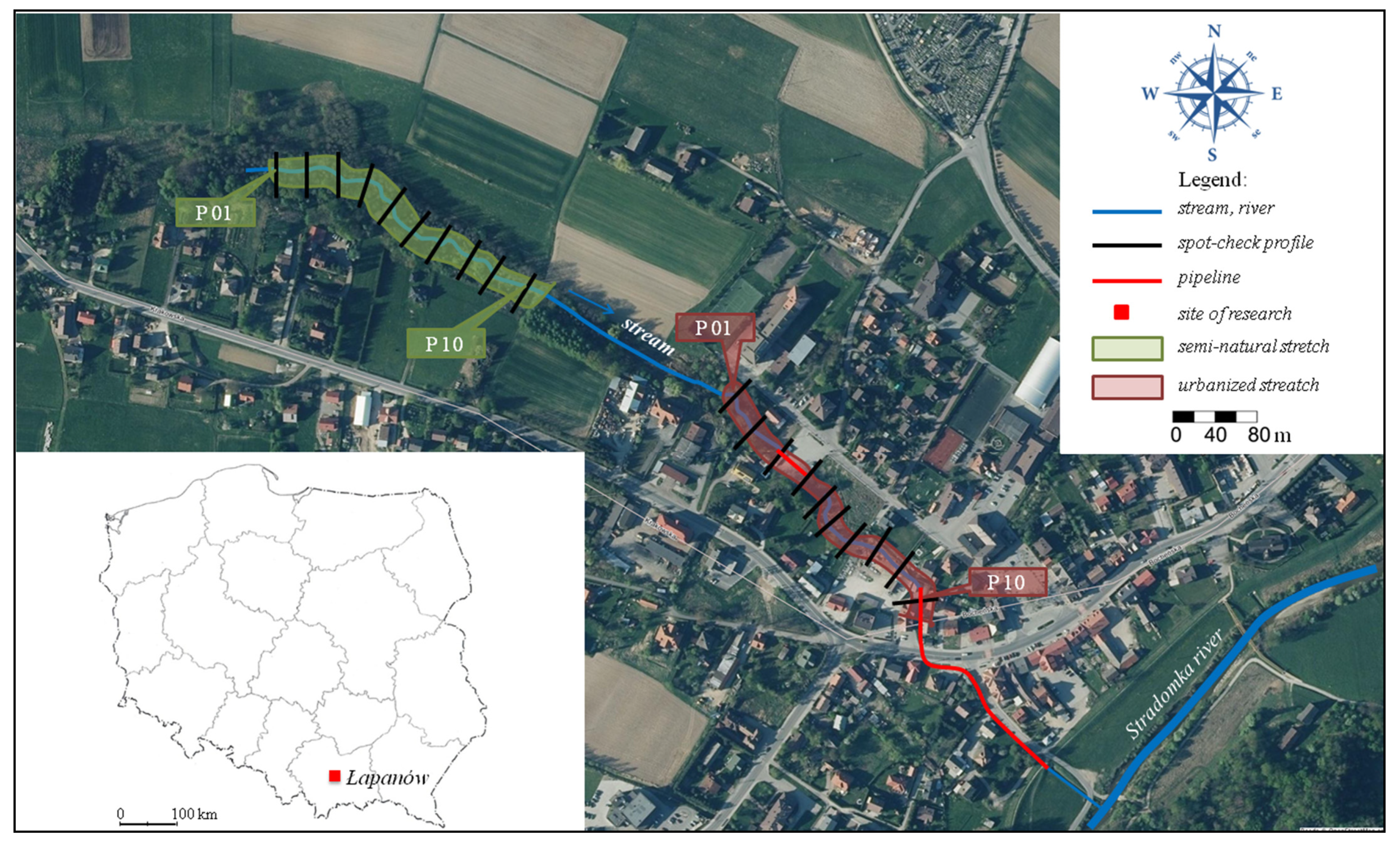
The hydromorphological evaluation of the ‘unnamed stream’ was performed in August 2020 with the use of the Hydromorphological Index for Rivers (HIR), which comprised of a field evaluation on two representative 300 m sections—semi-natural and urbanised—in which 10 control profiles (marked as P0–P10) were delimited about 30 m apart from each other, as well as a synthetic evaluation of the entire stream section (Figure 1). The study involved the determination of the presence and diversity of the natural elements of the stream and of the valley, and characterisation of the range of modifications in the watercourse’s morphology [30,42].
The land use in the stream valley was determined based on the orthophotomap from 2020, available at geoportal.gov.pl (accessed on 20 December 2021) (supported by a site visit), within a 100 m wide buffer on each bank; as a percentage of the area and then used to determine the weight coefficient (w) to calculate the mean HIR. Out of three basic land use forms, i.e., urbanised (U), agricultural (R) and semi-natural (S), the urbanised areas dominated in the buffer—sealed surfaces with dense or dispersed development, roads and other anthropogenic non-built-up areas, which made up about 58% of the buffer area (wU = 69.9). Next, there were semi-natural areas—forests, trees and shrubs, marshy areas, rush and herb vegetation, covering about 25% of the buffer area (wS = 30.1). The remaining 17% were agricultural areas—arable land, grassland and allotment gardens (wA = 0.0). Only the land use forms with a share ≥25% in the buffer were used in the calculation [42]. Two study sections were determined based on the land use analysis in the stream valley: the first in the semi-natural part, and the second in the urbanised part. Due to the stream features (its small length and partial pipelining) and the property conditions in the catchment area (the stream flows through private properties, often fenced), the study sections lengths were 300 m long instead of the standard 500 m, which is acceptable according to the authors of the method [30,42].
For each stretch, the HIR value was calculated. The multimetric HIR index combined two indices: The Hydromorphological Diversity Score (HDS) and the Habitat Modification Score (HMS). The HDS informed about the presence of natural attributes in the channel, coastal zone and the river valley. Each of the HDS attributes delivered a range of points, enabling the calculation of the HDS of the river stretch. HMS provided information on the hydromorphological modifications; it included various forms of fluvial ecosystem transformations, such as profile modifications and reinforcements, and the presence and abundance of engineering facilities. The detailed procedure of scoring is presented in the HIR method manual. In practice, HDS and HMS values usually do not exceed 100 [30,42].
The obtained values were compared with the classes for a given type of watercourse: class I HIR ≥ 0.824; class II HIR ≥ 0.715; class III HIR ≥ 0.600; class IV HIR ≥ 0.485; and class V HIR < 0.485.
The assessment of the hydromorphological state of the stream catchment consisted of calculating the weighted average of the HIR values, taking into account the weighting factor for three forms of land development (calculated on the basis of their percentage share in the buffer), according to the following formula:
where: HIRmean—average HIR value for the whole water body; HIRU—HIR calculated for the survey sites located in an urbanised area; wU—weighting factor for urbanised areas calculated on the basis of their percentage share in the buffer; HIRA—HIR calculated for the survey sites located in an agricultural area; wA—weighting factor for agricultural areas calculated on the basis of their percentage share in the buffer; HIRS—HIR calculated for the survey sites located in a semi-natural area; and wS—weighting factor for semi-natural areas calculated on the basis of their percentage share in the buffer.
3. Results
3.1. Meteorological and Hydrological Characteristics
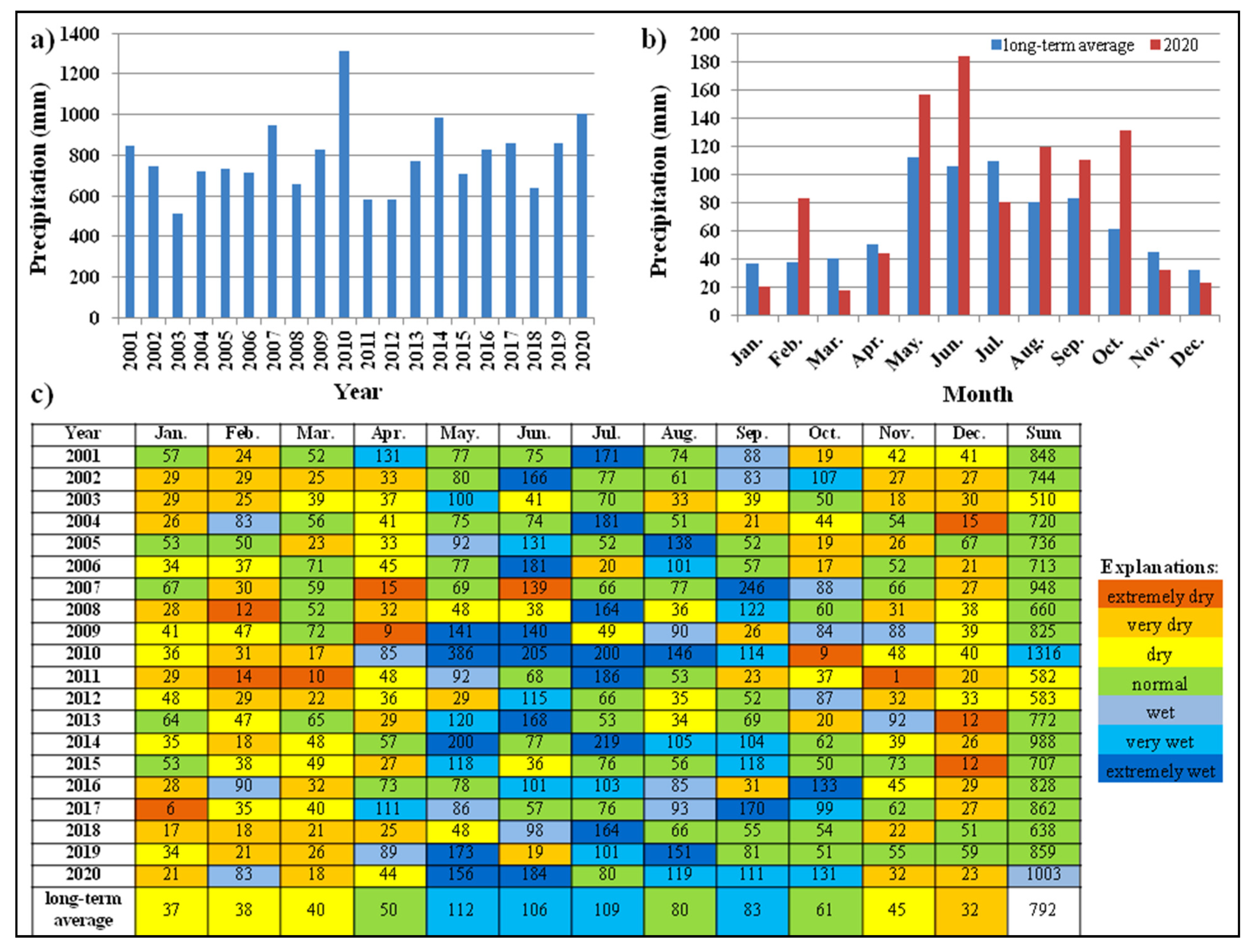
The characteristics of the meteorological conditions are presented in Figure 2 and Figure 3. The climate is fairly dry in the winter half-year, and is characterised by fairly hot summers, where short rain showers are quite common and often come in intense bursts.
Typically, 30% of the precipitation falls during the winter half-year and 70% during the summer half-year. In the multi annual period from 2001–2020, the average annual air temperature was 9.1 °C, and total precipitation was 792 mm. Increased average temperatures and rainfall are observed over the analysed period, which is in line with a report by the Institute of Meteorology and Water Management—National Research Institute, which has been monitoring Poland’s climate for over 100 years on an ongoing basis [43]. To assess the meteorological conditions of the region where the study was conducted, the relative precipitation index (RPI) values were calculated, as a measure of the precipitation efficiency in a given month and year. Based on the RPI values calculated for the months from 2001–2020, as shown in Figure 2c, it was determined that 112 of the months were dry, 63 of the months were optimal and 65 of the months were wet. In terms of precipitation, 2020 belonged to the wet year. The average multi annual temperature varies between 7.8 °C and 10.3 °C (Figure 3c). The water temperature depends on the air temperature which, in turn, translates into the amount of oxygen in the water [44]. The annual average temperature in 2020 was 0.7 °C higher than the multi annual average. In the analysed multi-year period, two years were very cold, six years were slightly cold, six years were normal, two were slightly warm, three years were warm and one year was very warm. In general, the variable meteorological conditions in the study area, characterised by periods of excesses and shortages of water, indicate the need for good maintenance of the hydromorphological conditions of watercourses, mainly drainage functions.
The average annual water flow of the unnamed stream is placed at SSQ = 0.004 m3·s−1 and corresponds to the flow measured directly (Q = 0.005 m3·s−1). The catchment basin of the stream receives water both from rainfall and from snow melt in the slope. The higher precipitation levels in 2020 lead to a higher supply of water to the stream. Based on conversations with residents, there have been dry years or months in which the stream did not carry water.
3.2. Catchment Characteristics
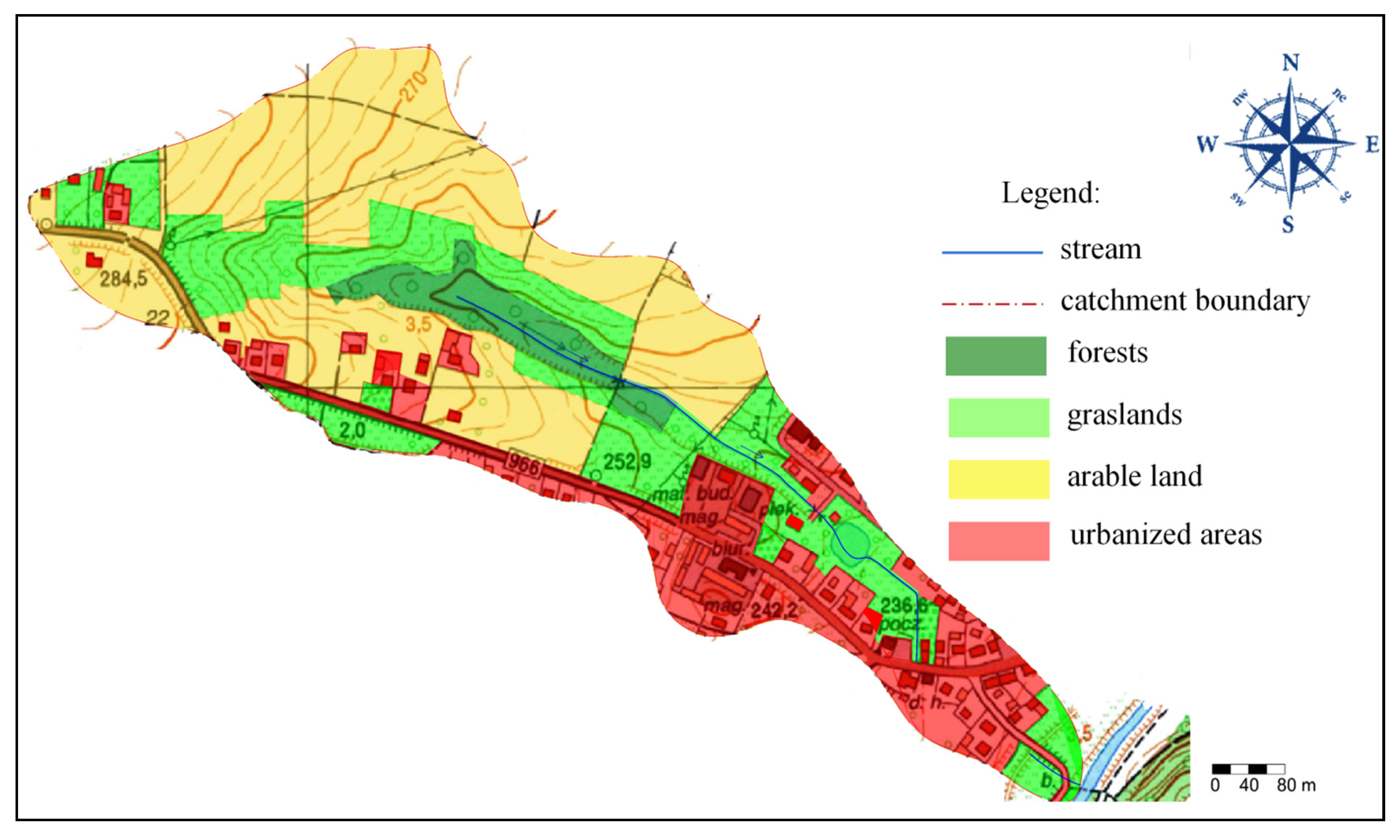
The basic physiographic parameters describing the catchment of the examined stream are presented in Table 3. The stream catchment area is very small (<10 km2). The catchment length is just over 1 km, its mean width is 0.23 km, and the perimeter is about 3 km. The form coefficient (Cf), elongation coefficient (Cw), circularity coefficient (Ck) and compactness coefficient (Cz) indicate that the stream catchment is narrow and elongated. The denivelation of the catchment area is 59 m, with a watershed slope of about 23.9‰. The mean altitude in the catchment is about 258 m a.s.l.
The dominant land use is arable land with slightly over 40% of the catchment area. The catchment afforestation rate is 6%. The trees and shrubs occur mainly in the stream valley, thus forming the natural biological development of the watershed bed. The urbanised area (dispersed and dense development) is 25%. Grassland (meadows/pastures) and wasteland with grass vegetation form about 28% of the catchment area (Table 3, Figure 4).
3.2.1. Characteristics of the Semi-Natural Section
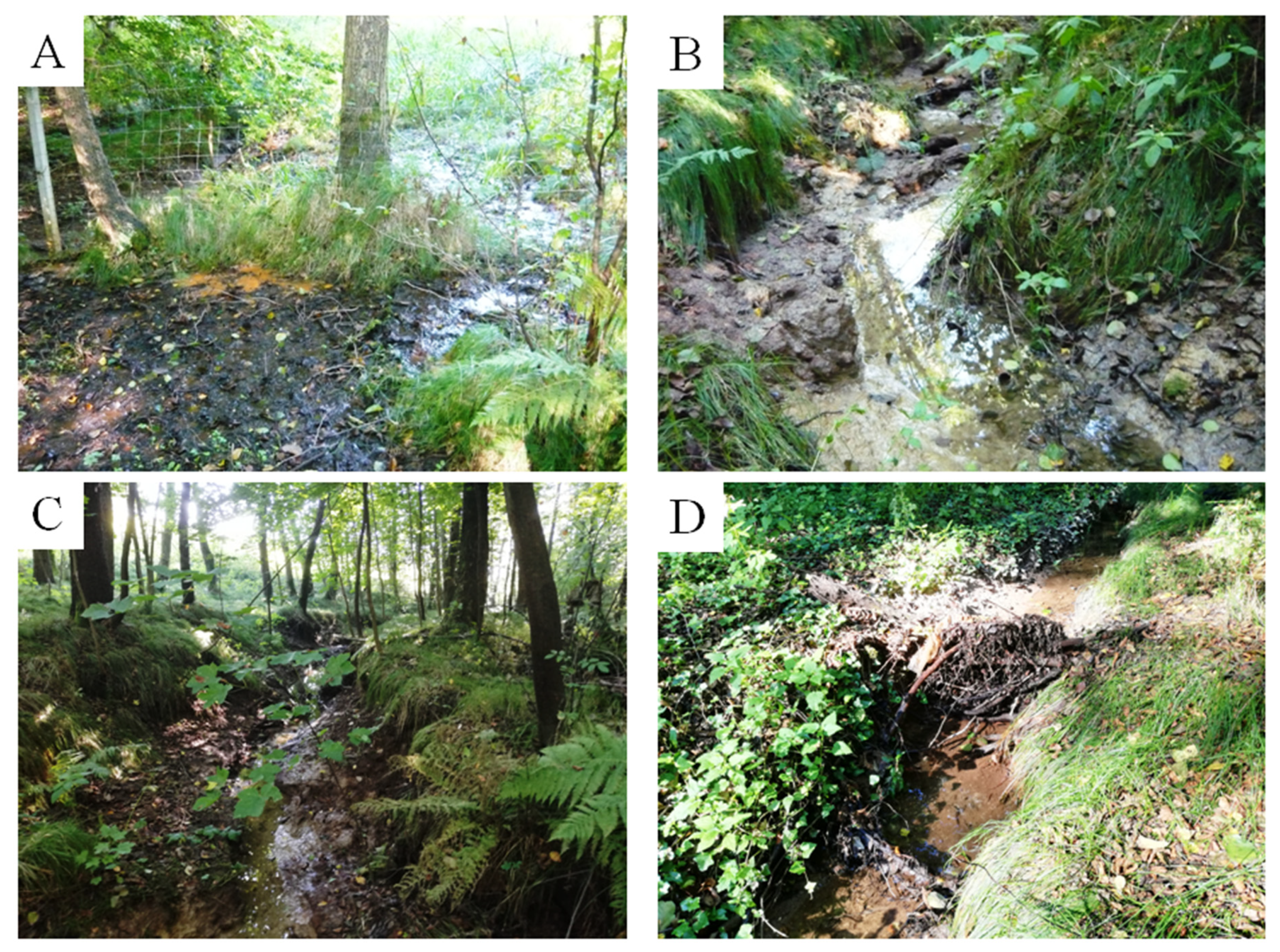
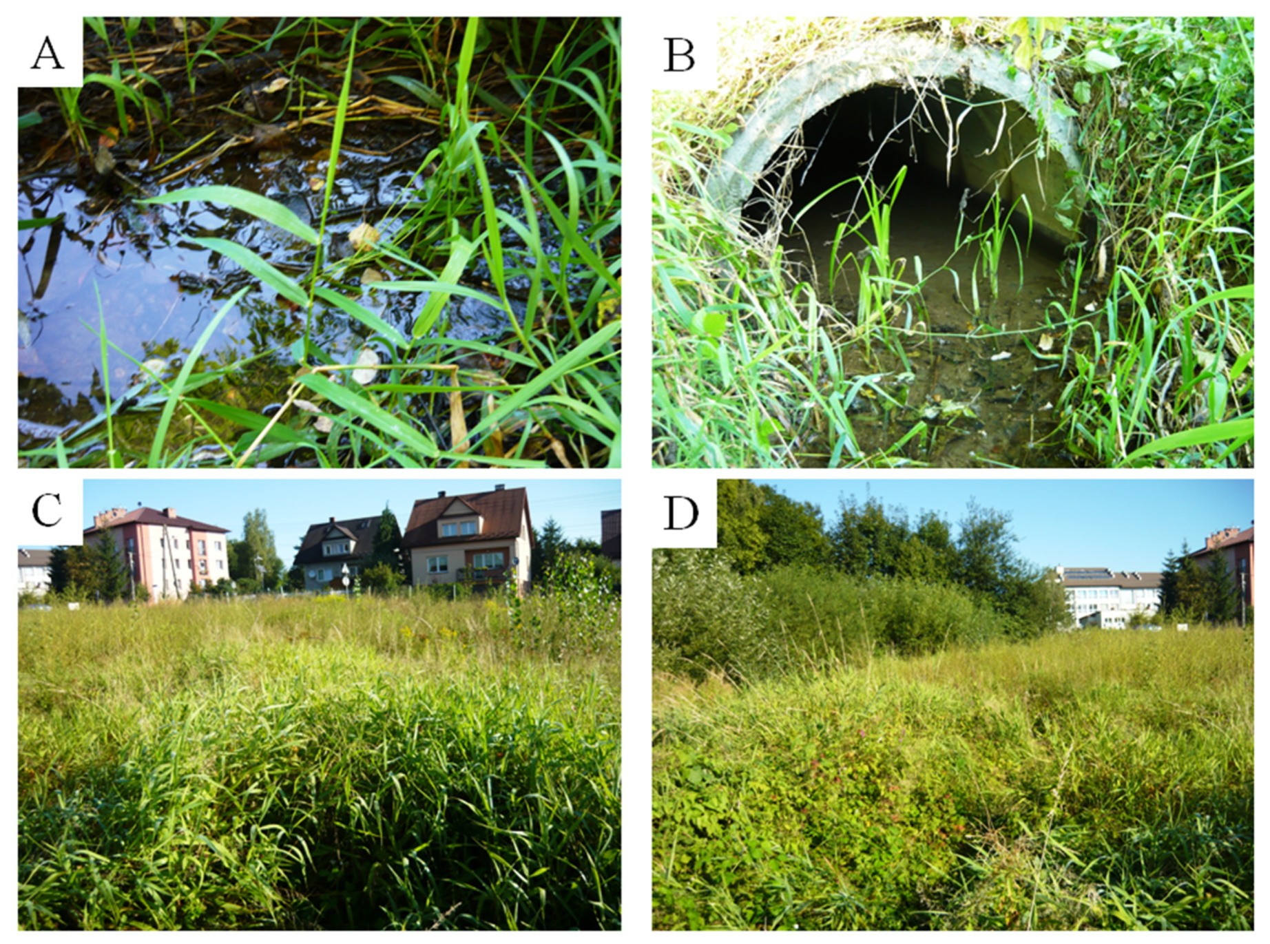
Marshy areas without a distinctively formed bed can be found near the control point P01—the spring area. Valuable environmental elements include marshy meadows, as a spring area in the form of a weak outflow of groundwaters to the surface (seeps, bogs). The dominant land use forms include forest, trees/shrubs and grassland (marshy meadows) (Figure 5A). From cross-section P02, the bed-bottom material is classified as clay and silt, sometimes covered with a thin layer of mud (Figure 5B). The average water depth is about 3.0 cm. No modifications in the bed and natural morphologic elements were found. Soil (loess) is deposited on the slopes. The banks’ cross-sections in the majority of the control profiles are eroded (as a result of water erosion), with vertical or underwashed banks of the stream. No modifications were found on the slopes, and the natural morphological elements include eroding bank undercuts with visible plant roots and numerous bank outwashes not fixed with vegetation (Figure 5C). There is no vegetation in the bed, and the vegetation appears on the slope as a uniform structure (Figure 5C) with ferns and grass vegetation, and as a complex structure on the slope tops with continuous tree stands (mainly maple, alder, oak, and spruce and grass vegetation). The stream valley in the semi-natural section is very shaded (50–75%). The land use in the areas near the banks is forest, trees and shrubs. The synthetic evaluation of the entire examined section (300 m) indicates an unobstructed flow in the bed, despite an occasional weak natural swelling by minute wood bed load (Figure 5D) and the vegetation in the bed and on the slope being typical of marshy areas (i.a. sedge). Detritus in the form of small-size dead organic matter from falling leaves and weak lateral tributaries can be found in the upper course of the stream. The laminar water flow dominates in the bed (this was the case when the studies were conducted, but rapid flow and overflow was also observed, mainly upstream in places where erosion faults/incisions formed small waterfalls). Florae were found in the stream valley, in the form of ivy (Hedera helix) and small balsam (Impatiens parviflora DC.) Faunae were also found, in the form of Roman snail (Helix pomatia) and slug. Debris classified as refuse/waste was also found the stream valley.
3.2.2. Hydromorphological Characteristics of the Urbanised Section
In the initial control profiles of the urbanised section (P01–P03), the dominant bed material is fine sand and dust covered by a layer of muddy sediments. The water flow in the bed is laminar (Figure 6A). The water level in the bed is about 6 cm. The left-hand and right-hand banks, in the 1 m wide strip, are made of loose material (soil). In the 5 m strip from the bank, there are semi-continuous trees and shrubs, and a simple vegetation structure on the top and slopes of the banks; these are mainly alder (Alnus), maple (Acer), oak (Quercus) and spruce (Picea abies); there is also moss (Bryophyta), particularly on the tree branches and ferns (Polypodiopsida). No water plants were found in the bed. The bank profile ranges from gentle, which is classed as <45° (left-hand bank), to steep, which is >45° (right-hand bank). Typical land use in the strip 50 metres away from the bank top was trees/shrubs and buildings (school, private houses). Shading of the bed is visible, as well as exposed roots and outgrowth on the slopes of both banks. The natural erosion-related morphological elements include an undercut on the right-hand bank.
Farther in the urbanised section, the dominant bed-bottom materials are still fine sand and silt. The water flow is laminar. For about 30 metres, the stream flows in the pipe (the closed bed) with a paved surface over it (the car park). Then, the water flows out of the Ø = 1.00 m concrete pipe (the culvert) (Figure 6B), and the flow is Q ≈ 0.005 m3∙s−1. There are no cross-section modifications in the open bed, and no natural morphological elements were found in the bed. The material of the right-hand and left-hand slopes is soil (sand and dust are dominating). No modifications on the right-hand and left-hand slopes, and no natural morphological elements were found. The bed is heavily overgrown with vegetation; these are mainly plants above the water surface or recumbent amphiphites. In section P04–P07, the watercourse runs through uncultivated land. There is simple vegetation structure on the right-hand bank in the form of single trees/shrubs—mainly willow (Salix), hazel (Corylus) and oak (Quercus)—and green vegetation—mainly reed (Phragmites australis) and sedge (Carex) (Figure 6C,D). Uniform vegetation—mainly grass vegetation (Phragmites australis)—and tall herb vegetation—mainly nettle (Urtica dioica)—dominate on the left-hand slope. Vegetation typical of marshy habitats and areas has also been found, i.e., purple loosestrife (Lythrum salicaria) and marsh horsetail (Equisetum palustre). The plot through which the stream flows is built up/developed on both sides. There is a road to the north with housing development along it, and single-family houses to the east (Figure 6C). Refuse/waste was found near the bank on the south side, behind the fence.
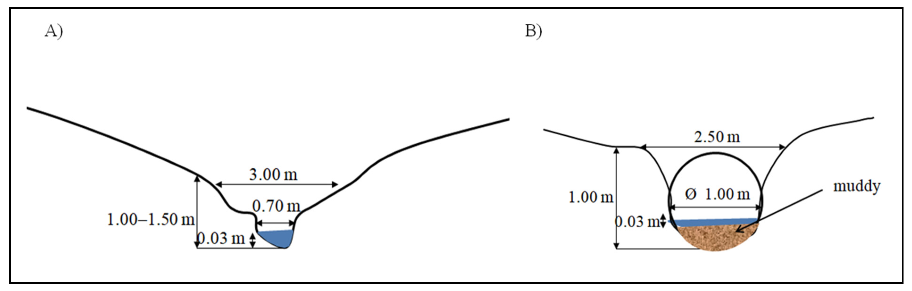
From profile P07 to P10, the stream bed is heavily overgrown with grass vegetation, with clear signs of anthropopression in the form of bottom- and slope- grading. The dominant bed-bottom material is fine sand. There is soil on the slopes. The water flow in the bed is laminar. Farther along, the stream is pipelined (concreted) and flows under the urban development; before flowing into the Stradomka river, the stream bed is open again with visible signs of grading and vegetation mowing (inter-embankment zone of the Stradomka river). In addition, from among the elements recorded in the synthetic evaluation, gullies and culverts were found. The bed dimension for the semi-natural and urbanised section are presented in Figure 7A,B, respectively.
The HDS index indicates the hydromorphological diversity of the stream. The HDS values calculated for the individual study sections are varied from 27 for the urbanised section to 56 for the semi-natural section (Table 4). The HDS values for the semi-natural section are mainly influenced by: the presence of the natural morphological elements of the slopes in the control profiles (17.8%); the diversity of elements accompanying the trees (14.3%); and the naturalness and heterogeneity of the stream valley use (14.3%). For the urbanised section, the highest percentage of HDS value is found in the bed material heterogeneity (15.0%), the natural morphological elements of the slopes (15.0%), the vegetation diversity in the channel bed (15.0%), and the structure of the bank vegetation (15.0%). The HMS values reflecting the degree of anthropogenic changes in the hydromorphology of streams and rivers indicate that the lower part of the examined stream is the most modified (Table 4). The score for the lower-urbanised stream section is 15.5, indicating a significant modification of the stream related mostly to the modifications in control profiles (38.7%), especially profiling the bottom and slopes of the stream and the disturbance of the connectivity with the river valley (25.8%); the latter is especially influenced by urban areas. The upper examined section, for which the HMS is 0, is a hydromorphological habitat which has not been significantly modified. It is located within the tree stand boundaries and remains almost in semi-natural conditions.
It is unequivocally found that the value of the HIR index varies significantly for the tested sections. The final HIR value for the semi-natural section is 0.78, and is 44% higher in relation to the urbanised section (0.54); the changes in its numerical value mainly depend on the heterogeneity of the water flow, the natural morphological elements of the slopes, the diversity of elements accompanying the trees, and the natural land use of the valley (Table 4 and Table 5). According to the classification [30], the hydromorphological condition in the semi-natural section is determined to be good, and in the urbanized section, to be poor. The hydromorphological condition of the whole stream is determined to be moderate (Table 5).
4. Discussion
In the catchment area of the analyzed stream, an increase in the sum of annual precipitation and the average annual temperature is visible. Carpathian streams play an important role in draining the local catchment area, especially during flash floods, which are appearing more and more frequently [45]. The highest flood risks in Poland are characteristics of the Carpathian tributaries of the upper Vistula river, including the catchment area of the studied stream [46]. The negative impact of extreme weather phenomena is already visible, with drought and soil erosion bringing major problems, especially in the Carpathian Region; however, as reported by Ionita et al. [47], the frequency of droughts has not unusually increased in Central Europe when compared to preindustrial drought records. Natural climate change has led to changes in the water regimes of small upland and mountain streams, thus causing the occurrence of flash floods, or the drying up of watercourses in late summer [48]. The results of climate models show that in the area of Poland, in the near and far future, there will be an increase in air temperatures and in precipitation [49,50,51]. On the other hand, according to Atwood et al. [52], Climate models are quite poor when it comes to rainfall on a regional level. Any future trends in rainfall coming from climate models have to be treated with utmost caution. Attempts to identify climate change in the city micro-environment and improvement through water retention are conducted in Slovakia [53].
The physiographic (geometrical and morphometric) parameters of the catchment indicate a mountainous character of the examined stream; this includes a small area and significant elongation, a mean elevation of >200 m a.s.l., and a large slope [54]. The results of hydromorphological evaluation revealed significant differences between the semi-natural and urbanised part of the stream, indicating regulation and canalisation as the main reasons for hydromorphological degradation. Studying the catchment areas of two Carpathian flysch streams (the Jaszcze and Jamne), Bucała-Hrabia and Wiejaczka [54] concluded that a higher diversity of hydromorphological forms, with a corresponding HDS, occurs in the upper and medium course of the streams in the upland landscape; they also concluded that a lower diversity occurs in the lower part of the streams’ catchment areas, which are subjected to anthropopression. A similar regularity of naturality and anthropogenic changes of the habitat between the upper and lower course of streams in Poland, India and China was shown by Kijowska-Strugała et al. [55].
The results of the scoring correspond to the preliminary hypothesis, according to which, despite the small stream, there is a noticeable difference between the analysed sections of the stream. An extensive amount of literature on linkages between the effects of anthropopression in stream habitats and river hydromorphology reports a number of relationships, at many levels. The need is urgent to develop refined and updated hydromorphological assessment systems targeting small ungauged watercourse evaluation, for use by the European Water Framework Directive (WFD) and national water-related policies. The topography and rich vegetation in the river’s catchment area may make it difficult to perform field studies. Recent studies shows that Unmanned Aerial Vehicles (UAVs) can be used for inventory and assessment of the shydromorphological status of streams and rivers, especially in hard-to-reach areas. Drones and digital photogrammetry now provide an alternative approach for monitoring river habitats and hydromorphology [56,57].
The aim of the research currently carried out in Ireland is to advance knowledge on the role of small streams in water quality, biodiversity and ecosystem services protection; this will inform policy, measures and management options to meet water quality and other resources protection targets [58].
As a rule, natural watercourses have a higher HDS and the artificial watercourses (ditches, channels) have a higher HMS [21]. Hajdukiewicz et al. [6] indicate sbed regulation and significant grading (canalisation of the river) as the main causes of the hydromorphological degradation of the Biała river. Bryndal et al. [59] prove that high human activity in the catchment area deteriorates its natural drainage/water removal, thus contributing to a more frequent occurrence of high water stage and floods. Bedla et al. [60] and Pietruczuk, et al. [61] indicate that that the excessive piping of a river or stream adversely affects the natural environment in their valleys, deteriorating the aesthetic values of landscape. The diversity of morphological forms (flow type, bottom and slope material) plays a significant role in the biodiversity of fauna and flora in the watercourse bed and valley [28,62,63]. This can be seen in the examined stream, where the vegetation cover of the watercourse body is much larger in the lower urbanised part of the stream than in the upper, semi-natural part (Table 4), characterised by a great slope and a larger dynamic of the flowing water. In the studied stream, it was demonstrated that, depending on the vegetation diversity, the HDS variation could change by about 25%. Furthermore, Kiraga [64] reported that, depending on the season, the vegetation diversity variation could change, which could lead to a step from one hydromorphological class to another. It was similar in the case of the HMS parameter, where modifications in the riverbed and stream valley were visible in the urbanised section. These changes significantly reduced the hydromorphological condition. It is well known that riparian vegetation plays a crucial role in sustaining river hydromorphological conditions [65]. Forests, trees and shrubs play an important part in the hydromorphological diversity of the zone near the stream banks. They act as biological protection (natural development) of the stream bed and valley, increasing the catchment retention, equalising the flows, and slowing down erosion of the stream slopes, bottom and banks. The root systems of these plants protect the soil from being washed out. Kałuża et al. [66] reported that, in the forested river reach, bottom and riverbank vegetation was completely absent. The river channel was narrow; however, due to the vicinity of trees and shrubs, considerable accumulation of organic matter was observed in the river channel. The flora acted as basic protection, mainly in the upper part of the catchment, where the land gradient was higher [62,67]. The majority of soils in the Wiśnicz Foothills, including the soils in the catchment of the examined stream, are made of Carpathian flysch (loess) which, without appropriate vegetation cover, are subject to intensive erosion [1,54].
5. Conclusions
The conclusions of the studies are as follows:
In its upper course, the stream has winding meanders, where the banks are subjected to erosion by flowing water, particularly during high water and high flow speed. In addition, it has low anthropopression and moderate diversity of morphological forms and conditions. Its lower course, on the other hand, has been significantly modified and transformed, in both the bed and the banks. The mouth part of the stream belongs to the intensively modified part of the surface waters. Factors significantly worsening hydromorphological conditions are various forms of anthropopressure, with particular emphasis on urbanization.
The evaluation indicates hydromorphological features of the stream which have been changed significantly at canalised sections, and which will most likely undergo the largest improvement when the bank protections are removed and the free channel migration is made possible, which—as a result of the progressing development of the lower part of the stream—is no longer possible.
This applied method can be used for the hydromorphological assessment and inventory of small, ungauged streams, because its scope includes elements that testify to the naturalness of stream habitats and a radical transformation in stream catchments. A major advantage of the HIR method is that it accounts for the HDS and HMS; this allows one to determine to what extent a given watercourse section is natural, and to what extent it is transformed. On the other hand, the final valorisation results are strongly affected by the presence of vegetation, which varies during the whole year. The type of water flow may also turn out to be an insufficient parameter—especially in periodic streams or those susceptible to rapid fluctuations in the water level after heavy rainfall.
This example of an examined stream indicates the need for more frequent monitoring the catchment areas of small streams not included in any hydrological classifications.
The authors believe that proper management of water resources in small, ungauged catchments lies with the local and regional authorities. All actions taken in the stream bed, and its catchment area, should be in accordance with the principle of sustainable development.
Based on this hydromorphological assessment, the results obtained helped us to evaluate the environmental changes and anthropogenic pressures on the stream sections; however, further research is required on the changes in the hydromorphological status of small watercourses.
Author Contributions
Conceptualization, Ł.B. and T.K.; methodology, Ł.B. and T.K.; software, Ł.B.; validation, Ł.B.; formal analysis, Ł.B. and T.K.; investigation, Ł.B. and T.K.; resources, Ł.B. and T.K.; data curation, Ł.B. and T.K.; writing—original draft preparation, Ł.B.; writing—review and editing, Ł.B. and T.K.; visualisation, Ł.B.; supervision, T.K.; project administration, Ł.B.; funding acquisition, T.K. All authors have read and agreed to the published version of the manuscript.
Funding
This research was funded by the Department of Land Reclamation and Environmental Development, Faculty of Environmental Engineering and Land Surveying, University of Agriculture in Krakow.
Institutional Review Board Statement
Not applicable.
Informed Consent Statement
Not applicable.
Data Availability Statement
Not applicable.
Conflicts of Interest
The authors declare no conflict of interest.
References
- Dawson, C.P.; Hendee, J.C. Introduction to Forests and Renewable Resources, 9th ed.; Waveland Press: Long Grove, IL, USA, 2019; Available online: https://books.google.pl/books?id=wZG4DwAAQBAJ&pg=PA430&lpg=PA430&dq=upland+stream+gradient&source=bl&ots=UMIyzqRIPy&sig=ACfU3U2VKor7jpnxwgScPDzliJYmtwLgOw&hl=pl&sa=X&ved=2ahUKEwjW74PP5L_0AhXilYsKHTexBLIQ6AF6BAg0EAM#v=onepage&q=upland%20stream%20gradient&f=false (accessed on 26 November 2021).
- Głowacki, W. Newly Emerging Geosites in the Polish Western Outer Carpathians as an Asset for Geoeducation and Geotourism. Geoheritage 2019, 11, 1247–1256. [Google Scholar] [CrossRef] [Green Version]
- Hauer, C.; Pulg, U. The non-fluvial nature of Western Norwegian rivers and the implications for channel patterns and sediment composition. Catena 2018, 171, 83–98. [Google Scholar] [CrossRef]
- Hauer, C.; Pulg, U. Buried and forgotten—The non-fluvial characteristics of postglacial rivers. River Res. Appl. 2021, 37, 123–127. [Google Scholar] [CrossRef] [Green Version]
- Kondracki, J. Regional Geography of Poland; PWN: Warszawa, Poland, 2011. (In Polish) [Google Scholar]
- Hajdukiewicz, H.; Wyżga, B.; Zawiejska, J.; Amirowicz, A.; Oglecki, P.; Radecki-Pawlik, A. Assessment of river hydromorphological quality for restoration purposes: An example of the application of RHQ method to a Polish Carpathian river. Acta Geophys. 2017, 65, 423–440. [Google Scholar] [CrossRef] [Green Version]
- Bryndal, T.; Kroczak, R. Reconstruction and characterization of the surface drainage system functioning during extreme rainfall: The analysis with use of the ALS-LIDAR data—the case study in two small flysch catchments (Outer Carpathian, Poland). Environ. Earth Sci. 2019, 78, 215. [Google Scholar] [CrossRef] [Green Version]
- Jakubínský, J.; Pelíšek, I.; Cudlín, P. Linking Hydromorphological Degradation with Environmental Status of Riparian Ecosystems: A Case Study in the Stropnice River Basin, Czech Republic. Forests 2020, 11, 460. [Google Scholar] [CrossRef] [Green Version]
- Bogdał, A.; Kowalik, T. Variability of values of physicochemical water quality indices along the length of the Iwoniczanka stream. J. Ecol. Eng. 2015, 16, 168–175. [Google Scholar] [CrossRef] [Green Version]
- Policht-Latawiec, A.; Bogdal, A.; Kanownik, W.; Kowalik, T.; Ostrowski, K. Variability of physicochemical properties of water of the transboundary Poprad river. J. Ecol. Eng. 2015, 16, 100–109. [Google Scholar] [CrossRef] [Green Version]
- Allaire, M.C.; Vogel, R.M.; Kroll, C.N. The hydromorphology of an urbanizing watershed using multivariate elasticity. Adv. Water Resour. 2015, 86, 147–154. [Google Scholar] [CrossRef]
- Vaughan, I.P.; Diamond, M.; Gurnell, A.M.; Hall, K.A.; Jenkins, A.; Milner, N.J.; Naylor, L.A.; Sear, D.A.; Woodward, G.; Ormerod, S.J. Integrating ecology with hydromorphology: A priority for river science and management. Aquat. Conserv. Mar. Freshw. Ecosyst. 2009, 19, 113–125. [Google Scholar] [CrossRef] [Green Version]
- Vogel, R.M. Hydromorphology. J. Water Resour. Plan. Manag. 2011, 137, 147–149. [Google Scholar] [CrossRef]
- European Commission. Directive 2000/60/EC of the European Parliament and of the Council of 23 October 2000 establishing a framework for community action in the field of water policy. Off. J. Eur. Community 2000, 60, 1–72. [Google Scholar]
- EN 14614; Water Quality—Guidance Standard for Assessing the Hydromorphological Features of Rivers. CEN: Brussels, Belgium, 2004; p. 21. Available online: http://www.safrass.com/partners_area/BSI%20Hydromorphology.pdf (accessed on 27 November 2021).
- EN 15843; Water Quality—Guidance Standard on Determining the Degree of Modification of River Hydromorphology. CEN: Brussels, Belgium, 2010; p. 24.
- Frissell, C.A.; Liss, W.J.; Warren, C.E.; Hurley, M.D. A hierarchical approach to classifying stream habitat features: Viewing streams in a watershed context. Environ. Manag. 1986, 10, 199–214. [Google Scholar] [CrossRef]
- Keogh, J.; Wilkes, R.; O’Boyle, S. A new index for the assessment of hydromorphology in transitional and coastal waters around Ireland. Mar. Pollut. Bull. 2020, 151, 110802. [Google Scholar] [CrossRef]
- Elosegi, A.; Sabater, S. Effects of hydromorphological impacts on river ecosystem functioning: A review and suggestions for assessing ecological impacts. Hydrobiologia 2013, 712, 129–143. [Google Scholar] [CrossRef]
- Belletti, B.; Rinaldi, M.; Buijse, A.D.; Gurnell, A.M.; Mosselman, E. A review of assessment methods for river hydromorphology. Environ. Earth Sci. 2015, 73, 2078–2100. [Google Scholar] [CrossRef]
- Brysiewicz, A.; Czerniejewski, P. Assessing Hydromorphological Characteristics of Small Watercourses Using the River Habitat Survey (RHS) Method. In Infrastructure and Environment, Krakowiak-Bal, A., Vaverkova, M., Eds.; Springer: Cham, Switzerland, 2019; pp. 144–153. [Google Scholar] [CrossRef]
- Stefanidis, K.; Latsiou, A.; Kouvarda, T.; Lampou, A.; Kalaitzakis, N.; Gritzalis, K.; Dimitriou, E. Disentangling the Main Components of Hydromorphological Modifications at Reach Scale in Rivers of Greece. Hydrology 2020, 7, 22. [Google Scholar] [CrossRef] [Green Version]
- Landerarbeitsgemeinschaft Wasser. LAWA Gewässerstrukturgütebewertung in der Bundesrepublik Deutschland, Verfahren für kleine und mittelgroße Fließgewässer; Landerarbeitsgemeinschaft Wasser: Schwerin, Germany, 2000. [Google Scholar]
- Wiatkowski, M.; Tomczyk, P. Comparative Assessment of the Hydromorphological Status of the Rivers Odra, Bystrzyca, and Ślęza Using the RHS, LAWA, QBR, and HEM Methods above and below the Hydropower Plants. Water 2018, 10, 855. [Google Scholar] [CrossRef] [Green Version]
- Brierley, G.J.; Fryirs, K.A. Geomorphology and River Management: Applications of the River Style Framework; Blackwell: Oxford, UK, 2005. [Google Scholar]
- Ollero, A.; Ballarín, D.; Díaz, E.; Mora, D.; Sánchez, M.; Acín, V.; Echeverría, M.T.; Granado, D.; Ibisate, A.; Sánchez, L.; et al. Un indice hidrogeomorfologico (IHG) para la evaluacion del estado ecologico de sistemas fluviales. Geographicalia 2007, 52, 113–141. [Google Scholar] [CrossRef] [Green Version]
- Rinaldi, M.; Belletti, B.; Van de Bund, W.; Bertoldi, W.; Gurnell, A.; Buijse, T.; Mosselman, E. Review on eco-hydromorphological methods. Deliverable 1.1, REFORM (REstoring rivers FOR effective catchment Management), Project funded by the European Commission within the 7th Framework Programme (2007–2013), Topic ENV.2011.2.1.2-1 hydromorphology and ecological objectives of WFD 2013, Grant Agreement 282656. Available online: https://www.researchgate.net/publication/282283692_Review_on_eco-hydromorphological_methods (accessed on 11 September 2021).
- Wyżga, B.; Amirowicz, A.; Radecki-Pawlik, A.; Zawiejska, J. Hydromorphological conditions, potential fish habitats and the fish community in a mountain river subjected to variable human impacts, the Czarny Dunajec, Polish Carpathians. River Res. Appl. 2009, 25, 517–536. [Google Scholar] [CrossRef]
- Gündüz, O.; Şimşek, C. Assessment of river alteration using a new hydromorphological index. Environ. Monit. Assess. 2021, 193, 1–19. [Google Scholar] [CrossRef]
- Szoszkiewicz, K.; Jusik, S.; Gebler, D.; Achtenberg, K.; Adynkiewicz-Piragas, M.; Radecki-Pawlik, A.; Okruszko, T.; Pietruczuk, K.; Przesmycki, M.; Nawrocki, P. Hydromorphological Index for Rivers: A New Method for Hydromorphological Assessment and Classification for Flowing Waters in Poland. J. Ecol. Eng. 2020, 21, 261–271. [Google Scholar] [CrossRef]
- Regulation of the Ministry of Environment dated 9 November 2011on the classification of ecological status, ecological potential and chemical status of surface water bodies (Dz.U. z 2011 r. nr 258, poz. 1549). Available online: https://www.ecolex.org/details/legislation/regulation-on-classification-of-ecological-status-ecological-potential-and-chemical-status-of-homogeneous-parts-of-surface-water-lex-faoc113849/ (accessed on 15 September 2021).
- Belda, M.; Holtanová, E.; Halenka, T.; Kalvová, J. Climate classification revisited: From Köppen to Trewartha. Clim. Res. 2014, 59, 1–13. [Google Scholar] [CrossRef] [Green Version]
- Gąsiorek, E.; Musiał, E. Comparison and classification of precipitation conditions based on standardized SPI and relative RPI precipitation indices. Water-Environ.-Rural. Areas 2011, 4, 107–119. (In Polish) [Google Scholar]
- Tomaszewska, T. Susze atmosferyczne na przestrzeni ostatniego czterdziestolecia. Mater. Konf. XXV Zjazd Agrometeorologów. Olsztyn–Mierki, 1994. Olsztyn. Wydaw. ART, s. 169–178. Available online: https://isap.sejm.gov.pl (accessed on 13 September 2021).
- Lorenc, H. Studia nad 220-letnią (1779–1998) serią temperatury powietrza w Warszawie oraz ocena jej wiekowych tendencji [Studies on 220-year air temperature for Warsaw (1779–1998) and the estimation of its multiyear tendencies]. Materiały Badawcze IMGW 2000. Warszawa. Ser. Meteorologia. Nr 31. ISSN 0239-6262, p. 104. Available online: https://books.google.com.hk/books/about/Studia_nad_220_letni%C4%85_1779_1998_seri%C4%85.html?id=wrAZHAAACAAJ&redir_esc=y (accessed on 13 September 2021).
- Lorenc, H. Termiczno-Opadowa Ocena Klimatycznych Sezonów Roku w Polsce Oraz Tendencje Czasowo-Przestrzenne. Projekt Badawczy M-9, IMGW 2000, Maszynopis. Available online: https://www.imgw.pl/sites/default/files/2020-08/imgw_wspolczesne-problemy-klimatu-polski.pdf (accessed on 12 September 2021).
- Punzet, J. Empiryczny system ocen charakterystycznych przepływów rzek i potoków w karpackiej części Dorzecza Wisły. Wiadomości IMGW 1981, 1–2, 31–39. [Google Scholar]
- Wałęga, A.; Młyński, D.; Wojkowski, J.; Radecki-Pawlik, A.; Lepeška, T. New Empirical Model Using Landscape Hydric Potential Method to Estimate Median Peak Discharges in Mountain Ungauged Catchments. Water 2020, 12, 983. [Google Scholar] [CrossRef] [Green Version]
- Młyński, D.; Wałęga, A.; Stachura, T.; Kaczor, G. A New Empirical Approach to Calculating Flood Frequency in Ungauged Catchments: A Case Study of the Upper Vistula Basin, Poland. Water 2019, 11, 601. [Google Scholar] [CrossRef] [Green Version]
- Sassolas-Serrayet, T.; Cattin, R.; Ferry, M. The shape of watersheds. Nat. Commun. 2018, 9, 3791. [Google Scholar] [CrossRef] [PubMed] [Green Version]
- Pałeczkowska, E. Slope-Fluvial System Structure in the Western Tatra Mountains (Poland): Slope-to-Channel Transition. Arct. Antarct. Alp. Res. 2017, 49, 569–583. [Google Scholar] [CrossRef] [Green Version]
- Szoszkiewicz, K.; Jusik, S.; Adynkiewicz-Piragas, M.; Gebler, D.; Achtenberg, K.; Radecki-Pawlik, A.; Okruszko, T.; Gielczewski, M.; Pietruczuk, K.; Przesmycki, M.; et al. Podręcznik Oceny Wód Płynących w Oparciu o Hydromorfologiczny Indeks Rzeczny; Biblioteka Monitoringu Środowiska: Warszawa, Poland, 2017; p. 189. [Google Scholar]
- Institute of Meteorology and Water Management–National Research Institute. Climate of Poland in 2020. Available online: https://www.imgw.pl/sites/default/files/2021-04/imgw-pib-klimat-polski-2020-opracowanie-final-eng-rozkladowki-min.pdf. (accessed on 6 January 2022).
- Rajwa-Kuligiewicz, A.; Bialik, R.J.; Rowiński, P.M. Dissolved oxygen and water temperature dynamics in lowland rivers over various timescales. J. Hydrol. Hydromech. 2015, 63, 353–363. [Google Scholar] [CrossRef] [Green Version]
- Baran-Zgłobicka, B.; Godziszewska, D.; Zgłobicki, W. The Flash Floods Risk in the Local Spatial Planning (Case Study: Lublin Upland, E Poland). Resources 2021, 10, 14. [Google Scholar] [CrossRef]
- Zeleňáková, M.; Kubiak-Wójcicka, K.; Negm, A.M. (Eds.) Management of Water Resources in Poland; Springer Water: Cham, Switzerland, 2021; p. 429. [Google Scholar]
- Ionita, M.; Dima, M.; Nagavciuc, V.; Scholz, P.; Lohmann, G. Past megadroughts in central Europe were longer, more severe and less warm than modern droughts. Commun. Earth Environ. 2021, 2, 61. [Google Scholar] [CrossRef]
- Peszek, Ł.; Zgrundo, A.; Noga, T.; Kochman-Kędziora, N.; Poradowska, A.; Rybak, M.; Puchalski, C.; Lee, J. The influence of drought on diatom assemblages in a temperate climate zone: A case study from the Carpathian Mountains, Poland. Ecol. Indic. 2021, 125, 107579. [Google Scholar] [CrossRef]
- Kundzewicz, Z.W.; Piniewski, M.; Mezghani, A.; Okruszko, T.; Pińskwar, I.; Kardel, I.; Hov, Ø.; Szcześniak, M.; Szwed, M.; Benestad, R.E.; et al. Assessment of climate change and associated impact on selected sectors in Poland. Acta Geophys. 2018, 66, 1509–1523. [Google Scholar] [CrossRef] [Green Version]
- Ziernicka-Wojtaszek, A.; Kopcińska, J. Variation in Atmospheric Precipitation in Poland in the Years 2001–2018. Atmosphere 2020, 11, 794. [Google Scholar] [CrossRef]
- Sojka, M.; Kozłowski, M.; Kęsicka, B.; Wróżyński, R.; Stasik, R.; Napierała, M.; Jaskuła, J.; Liberacki, D. The Effect of Climate Change on Controlled Drainage Effectiveness in the Context of Groundwater Dynamics, Surface, and Drainage Outflows. Central-Western Poland Case Study. Agronomy 2020, 10, 625. [Google Scholar] [CrossRef]
- Atwood, A.R.; Battisti, D.S.; Wu, E.; Frierson, D.M.W.; Sachs, J.P. Data-Model Comparisons of Tropical Hydroclimate Changes Over the Common Era. Paleoceanogr. Paleoclimatology 2021, 36, 7. [Google Scholar] [CrossRef]
- Pokrývková, J.; Jurík, Ľ.; Lackóová, L.; Halászová, K.; Hanzlík, R.; Banihabib, M.E. The Urban Environment Impact of Climate Change Study and Proposal of the City Micro-Environment Improvement. Sustainability 2021, 13, 4096. [Google Scholar] [CrossRef]
- Bucała, A.; Wiejaczka, Ł. Evaluation of the hydromorphological state of mountain streams under the influence of contemporary human activity (Polish Carpathians). Environ. Earth Sci. 2015, 73, 3451–3463. [Google Scholar] [CrossRef]
- Kijowska-Strugała, M.; Wiejaczka, Ł.; Cebulski, J.; Płaczkowska, E.; Rączkowska, Z.; Prokop, P.; Zou, Q.; Guo, Y.; Hu, J. Assessment of the naturalness and anthropogenic transformation of the habitats of small mountain streams in different climate zones. Environ. Earth Sci. 2021, 80, 267. [Google Scholar] [CrossRef]
- Casado, M.R.; Gonzalez, R.B.; Kriechbaumer, T.; Veal, A. Automated Identification of River Hydromorphological Features Using UAV High Resolution Aerial Imagery. Sensors 2015, 15, 27969–27989. [Google Scholar] [CrossRef] [Green Version]
- Woodget, A.S.; Austrums, R.; Maddock, I.P.; Habit, E. Drones and digital photogrammetry: From classifications to continuums for monitoring river habitat and hydromorphology. WIREs Water 2017, 4, e1222. [Google Scholar] [CrossRef] [Green Version]
- Kelly-Quinn, M.; Bruen, M.; Carlsson, J.; Gurnell, A.; Jarvie, H.; Piggott, J. Managing the small stream network for improved water quality, biodiversity and ecosystem services protection (SSNet). Res. Ideas Outcomes 2019, 5, e33400. [Google Scholar] [CrossRef]
- Bryndal, T.; Kroczak, R.; Kijowska-Strugała, M.; Bochenek, W. How human interference changes the drainage network operating during heavy rainfalls in a medium-high relief flysch mountain catchment? The case study of the Bystrzanka catchment (Outer Carpathians, Poland). Catena 2020, 194, 104662. [Google Scholar] [CrossRef]
- Bedla, D.; Halecki, W.; Król, K. Hydromorphological method and GIS tools with a web application to assess a semi-natural urbanised river. J. Environ. Eng. Landsc. Manag. 2021, 29, 21–32. [Google Scholar] [CrossRef]
- Pietruczuk, K.; Dajewski, K.; Garbarczyk, A.; Szoszkiewicz, K. Hydromorphological variability of a large lowland river based on the Hydromorphological Index for Rivers (HIR) basing on the Warta River. Ecol. Eng. 2020, 21, 15–25. [Google Scholar] [CrossRef]
- Gebler, D.; Szoszkiewicz, K.; Bielak, S.R. Diversity of hydromorphological conditions of rivers in the lowland and mountain catchment scale. Sci. Nat. Technol. 2013, 7, 1–12. [Google Scholar]
- Halabowski, D.; Lewin, I. Impact of anthropogenic transformations on the vegetation of selected abiotic types of rivers in two ecoregions (Southern Poland). Knowl. Manag. Aquat. Ecosyst. 2020, 421, 1–15. [Google Scholar] [CrossRef]
- Kiraga, M.J. The Diversification of River Habitat Survey Output During Four Seasons: Case Studies of Three Lowland Rivers in Poland. J. Ecol. Eng. 2020, 21, 116–126. [Google Scholar] [CrossRef]
- González del Tánago, M.; Martínez-Fernández, V.; Aguiar, F.C.; Bertoldi, W.; Dufour, S.; García de Jalón, D.; Garófano-Gómez, V.; Mandzukovskih, D.; Rodríguez-González, P.M. Improving river hydromorphological assessment through better integration of riparian vegetation: Scientific evidence and guidelines. J. Environ. Manag. 2021, 292, 112730. [Google Scholar] [CrossRef]
- Kałuża, T.; Sojka, M.; Wróżyński, R.; Jaskuła, J.; Zaborowski, S.; Hämmerling, M. Modeling of River Channel Shading as a Factor for Changes in Hydromorphological Conditions of Small Lowland Rivers. Water 2020, 12, 527. [Google Scholar] [CrossRef] [Green Version]
- Qazi, N. Hydrological functioning of forested catchments, Central Himalayan Region, India. For. Ecosyst. 2020, 7, 63. [Google Scholar] [CrossRef]
- Aduah, M.S.; Jewitt, G.P.W.; Toucher, M.L.W. Assessing Impacts of Land Use Changes on the Hydrology of a Lowland Rainforest Catchment in Ghana, West Africa. Water 2018, 10, 9. [Google Scholar] [CrossRef] [Green Version]
- Szatten, D.; Habel, M. Effects of Land Cover Changes on Sediment and Nutrient Balance in the Catchment with Cascade-Dammed Waters. Remote Sens. 2020, 12, 3414. [Google Scholar] [CrossRef]
- Borek, Ł. Assessment and classification of hydromorphological state of the Breń River. J. Water Land Dev. 2016, 30, 21–27. [Google Scholar] [CrossRef]
Figure 1.
Location of the studies and sections with control profiles on the stream.

Figure 2.
The characteristics of the precipitation conditions: (a) average annual precipitation in 2001–2020; (b) average monthly precipitation from the multi-year period 2001–2020 and in 2020; (c) classification of precipitation conditions on the basis of Relative Precipitation Index (RPI) for the months and years.

Figure 3.
The characteristics of the thermal conditions: (a) average annual temperature in 2001–2020; (b) average monthly temperature from the multi-year period 2001–2020 and in 2020; (c) monthly thermal classification proposed by Lorenc (2000).
Figure 3.
The characteristics of the thermal conditions: (a) average annual temperature in 2001–2020; (b) average monthly temperature from the multi-year period 2001–2020 and in 2020; (c) monthly thermal classification proposed by Lorenc (2000).

Figure 4.
Land use structure in the stream catchment.

Figure 5.
Selected elements of the hydromorphological diversity index in the semi-natural section: (A)—marshy areas and spring zone; (B)—laminar water flow; uniform vegetation on the slopes; (C)—eroding bank undercuts; bank outwash not fixed with vegetation; (D)—natural swelling by small wood bed load.

Figure 6.
Selected elements of the hydromorphological diversity index in the urbanised section: (A)—overgrown bed with laminar flow; (B)—outlet of Ø 1.00 m concrete culvert; (C)—grass vegetation (wasteland) and built-up areas; (D)—trees and shrubs. Grass vegetation (wasteland).
Figure 6.
Selected elements of the hydromorphological diversity index in the urbanised section: (A)—overgrown bed with laminar flow; (B)—outlet of Ø 1.00 m concrete culvert; (C)—grass vegetation (wasteland) and built-up areas; (D)—trees and shrubs. Grass vegetation (wasteland).

Figure 7.
Bed dimensions: (A)—semi-natural section; (B)—urbanised section.


Table 1.
Thermal classification of months, seasons and years.
| Month, Period, Year | Criteria |
|---|---|
| extremely cold | T > Tav + 2.5δ |
| anomalously cold | Tav + 2.0δ < T ≤ Tav + 2.5δ |
| very cold | Tav + 1.5δ < T ≤ Tav + 2δ |
| cold | Tav + δ < T ≤ Tav + 1.5δ |
| slightly cold | Tav + 0.5δ < T ≤ Tav + δ |
| normal | Tav – 0.5δ < T ≤ Tav + 0.5δ |
| slightly warm | Tav – δ < T ≤ Tav – 0.5δ |
| warm | Tav – 0.5δ < T ≤ Tav – δ |
| very warm | Tav – δ < T ≤ Tav – 1.5δ |
| anomalously warm | Tav – 1.5δ < T ≤ Tav – 2δ |
| extremely warm | T ≤ Tav – 2.5δ |
Explanations: T—air temperature in a given period; Tav—long-term average temperature in a given multi-year period; δ—standard deviation of air temperature in a given period. Source: elaborated according to Lorenc (2000).
Table 2.
Characteristics describing the stream catchment physiographic conditions.
| Item | Parameter |
|---|---|
| 1 | Topographic catchment area A [km2]—determined based on the planimetry of the area, which is closed by the boundary determining the topographic watershed |
| 2 | Maximum catchment length Lmax. [km]—main river valley length from the mouth to the point on the watershed in the extension of the spring |
| 3 | Catchment perimeter P [km]—length of the catchment’s topographic watershed |
| 4 | Catchment mean width Bz [km]—ratio of the catchment topographic area (A) to the catchment length (Lmax.): |
| 5 | Form coefficient Cf [–]*—ratio of the catchment area (A); ratio of the catchment area squared (Lmax.2): |
| 6 | Elongation coefficient CW [–]—ratio of the diameter of the circle of surface area equal to the catchment area, to the catchment length (L): |
| 7 | Circularity coefficient CK [–]—ratio of the catchment area (A), to the surface area of the circle of the same perimeter as the catchment perimeter (P): |
| 8 | Gravelius catchment compactness coefficient GC [–]—ratio of the catchment perimeter (Oz), to the perimeter of the circle of the same surface area as the catchment area (A): |
| 9 | Minimum Hmin and Hmax [m a.s.l.]—taken from the topographic map as the lowest and the highest value on the watershed |
| 10 | Altitude H [m a.s.l.]—taken from the topographic map as the lowest altitude (Hmin.) and the highest altitude (Hmax.) of the spring (Hs.) and mouth (Hm,) on the watershed |
| 11 | Channel mean altitude Hmean [m a.s.l.]—arithmetic mean of the maximum altitude (Hmax) and the minimum altitude (Hmin) in the catchment area: and from the Reitz formula: |
| 12 | Catchment area denivelation (∆H)—difference between the maximum (Hmax) and minimum (Hmin) altitude in the catchment area: ∆H = Hmax − Hmin [m] |
| 13 | Stream gradient/slope [%]—ratio of the altitude difference between the watercourse spring (Hs m a.s.l.) and mouth (Hm m a.s.l to the watercourse length in this section (Ls in m): |
| 14 | Stream length Ls (km)—distance from the spring to the mouth |
| 15 | Land use types in catchment (%)—percentages of the various forms of use in the catchment area as arable land, forests etc. |
Explanations: * [–]—dimensionless indicator/parameter.
Table 3.
Physiographic parameters of the studies stream catchment.
| Parameter | Value | |
|---|---|---|
| Catchment Geometry | ||
| Topographic catchment area (A): | 0.31 km2 | |
| Maximum catchment length (Lmax.): | 1.37 km | |
| Catchment perimeter (P): | 3.10 km | |
| Mean catchment width (Bz): | 0.23 km | |
| Shape coefficient: | form (Cf): | 0.17 |
| elongation (Cw): | 0.46 | |
| circularity (Ck): | 0.41 | |
| Gravelius compactness (GC): | 1.57 | |
| Catchment Morphometry | ||
| Altitude: | minimum/mouth (Hmin.): | 229.10 m a.s.l. |
| maximum (Hmax.): | 288.30 m a.s.l. | |
| spring (Hźr.): | 253.00 m a.s.l. | |
| mean (Hśr.): | 258.70 m a.s.l. | |
| mean (Hśr.) acc. to Reitz: | 257.44 m a.s.l. | |
| Denivelation (∆H): | 59.20 m | |
| Stream gradient/slope (Jc): | 2.4% (23.9‰) | |
| Catchment Hydrography | ||
| Stream length (Lc): | ~1.00 km | |
| Type of Land Use | ||
| Forests | 6% | |
| Arable land | 41% | |
| Grassland | 28% | |
| Built-up areas | 25% | |
| Sum | 100% | |
Table 4.
Components of the Hydromorphological Diversity Score (HDS) and the Hydromorphology Modification Score (HMS).
Table 4.
Components of the Hydromorphological Diversity Score (HDS) and the Hydromorphology Modification Score (HMS).
| Parameters Collected during the On-Site Evaluation | Section | |
|---|---|---|
| Semi-Natural | Urbanised | |
| HDS | ||
| 1. The stream channel zone—riverbed | ||
| 1.1. Variation of the river line | 3.0 (5.3%) | 0.0 (0.0%) |
| 1.2. Variation of the riverbed slope | 3.0 (5.3%) | 1.0 (3.5%) |
| 1.3. Heterogeneity of water flow | 5.0 (9.0%) | 3.0 (11.0%) |
| 1.4. Bed material heterogeneity | 4.0 (7.3%) | 4.0 (15.0%) |
| 1.5. Natural morphological elements of the bed-bottom | 1.0 (1.8%) | 0.0 (0.0%) |
| 1.6. Natural morphological elements of the slopes | 10.0 (17.8%) | 4.0 (15.0%) |
| 1.7. Vegetation diversity in the bed | 5.0 (9.0%) | 4.0 (15.0%) |
| 2. The stream channel zone—bank face | ||
| 2.1. Vegetation structure on the slopes | 0.0 (0.0%) | 0.0 (0.0%) |
| 2.2. Diversity of elements accompanying the trees | 8.0 (14.3%) | 1.0 (3.5%) |
| 3. The stream valley adjacent to the bank-top zone | ||
| 3.1. Structure of bank-top vegetation | 5.0 (9.0%) | 4.0 (15.0%) |
| 3.2. Not-managed bank-top zone | 4.0 (7.3%) | 3.0 (11.0%) |
| 4. The stream valley zone | ||
| 4.1. Natural land use of the valley | 8.0 (14.3%) | 3.0 (11.0%) |
| 4.2. Connection between the stream and the valley | 0.0 (0.0%) | 0.0 (0.0%) |
| ƩHDS | 56.0 (100%) | 27.0 (100%) |
| HMS | ||
| 1. Transformed transverse section of the stream channel | 0.0 (0.0%) | 2.0 (12.9%) |
| 2. Hydroengineering structures | 0.0 (0.0%) | 0.5 (3.2%) |
| 3. Transformations observed in spot-checks | 0.0 (0.0%) | 6.0 (38.7%) |
| 4. Disturbance of the connectivity with the river valley | 0.0 (0.0%) | 4.0 (25.8%) |
| 5. Other types of human degradation | 0.0 (0.0%) | 3.0 (19.4%) |
| ƩHMS | 0.0 (0.0%) | 15.5 (100%) |
Table 5.
Results of hydromorphological evaluation and quality classes of individual examined sections and the whole stream.
Table 5.
Results of hydromorphological evaluation and quality classes of individual examined sections and the whole stream.
| Item | Measuring Section | Study Section | Watercourse/Stream (Whole) | ||||
|---|---|---|---|---|---|---|---|
| HIR | Hydromorphological Condition | Class | HIRmean | Hydromorphological Condition | Class | ||
| 1 | semi-natural | 0.78 | good | II | 0.61 | moderate | III |
| 2 | urbanised | 0.54 | poor | IV | |||
Publisher’s Note: MDPI stays neutral with regard to jurisdictional claims in published maps and institutional affiliations. |
© 2022 by the authors. Licensee MDPI, Basel, Switzerland. This article is an open access article distributed under the terms and conditions of the Creative Commons Attribution (CC BY) license (https://creativecommons.org/licenses/by/4.0/).
Share and Cite
MDPI and ACS Style
Borek, Ł.; Kowalik, T. Hydromorphological Inventory and Evaluation of the Upland Stream: Case Study of a Small Ungauged Catchment in Western Carpathians, Poland. Land 2022, 11, 141. https://0-doi-org.brum.beds.ac.uk/10.3390/land11010141
AMA Style
Borek Ł, Kowalik T. Hydromorphological Inventory and Evaluation of the Upland Stream: Case Study of a Small Ungauged Catchment in Western Carpathians, Poland. Land. 2022; 11(1):141. https://0-doi-org.brum.beds.ac.uk/10.3390/land11010141
Chicago/Turabian StyleBorek, Łukasz, and Tomasz Kowalik. 2022. "Hydromorphological Inventory and Evaluation of the Upland Stream: Case Study of a Small Ungauged Catchment in Western Carpathians, Poland" Land 11, no. 1: 141. https://0-doi-org.brum.beds.ac.uk/10.3390/land11010141
Note that from the first issue of 2016, this journal uses article numbers instead of page numbers. See further details here.