
Impact of Future Development Scenario Selection on Landscape Ecological Risk in the Chengdu-Chongqing Economic Zone

 ,
,  ,
, 
 and
and
Abstract
:1. Introduction
2. Materials and Methods
2.1. Study Area
2.2. Data Sources
2.3. Methods
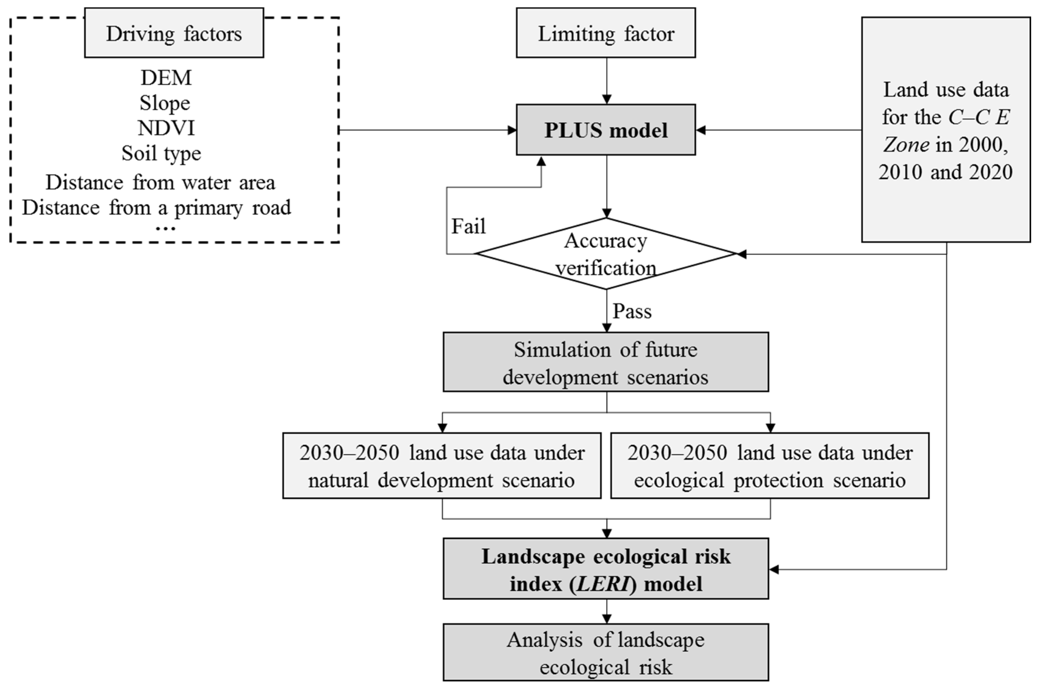
2.3.1. PLUS Model
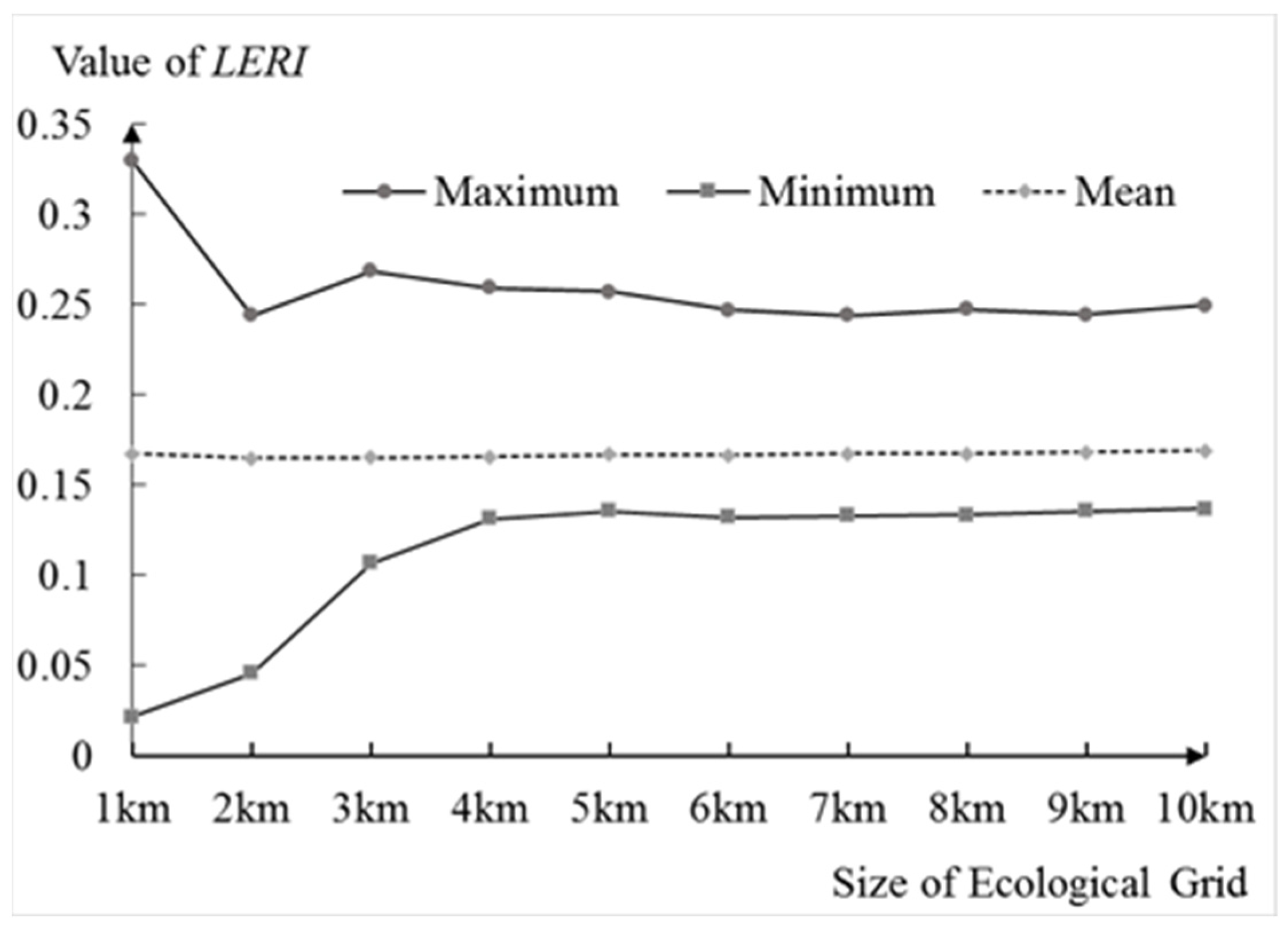
2.3.2. Determination of the Optimal Size of the Ecological Grid
2.3.3. Building the Landscape Ecological Risk Index (LERI) Model
2.3.4. Calculation and Classification of Landscape Ecological Risk
2.3.5. Getis-Ord Gi* Analysis
3. Results
3.1. Simulation Accuracy Analysis of Land Use Data
3.2. Trend Analysis of Land Use Evolution from 2000 to 2050
3.3. Analysis of the Optimal Size of the Ecological Grid
3.4. Analysis of the Calculation Results of LERI
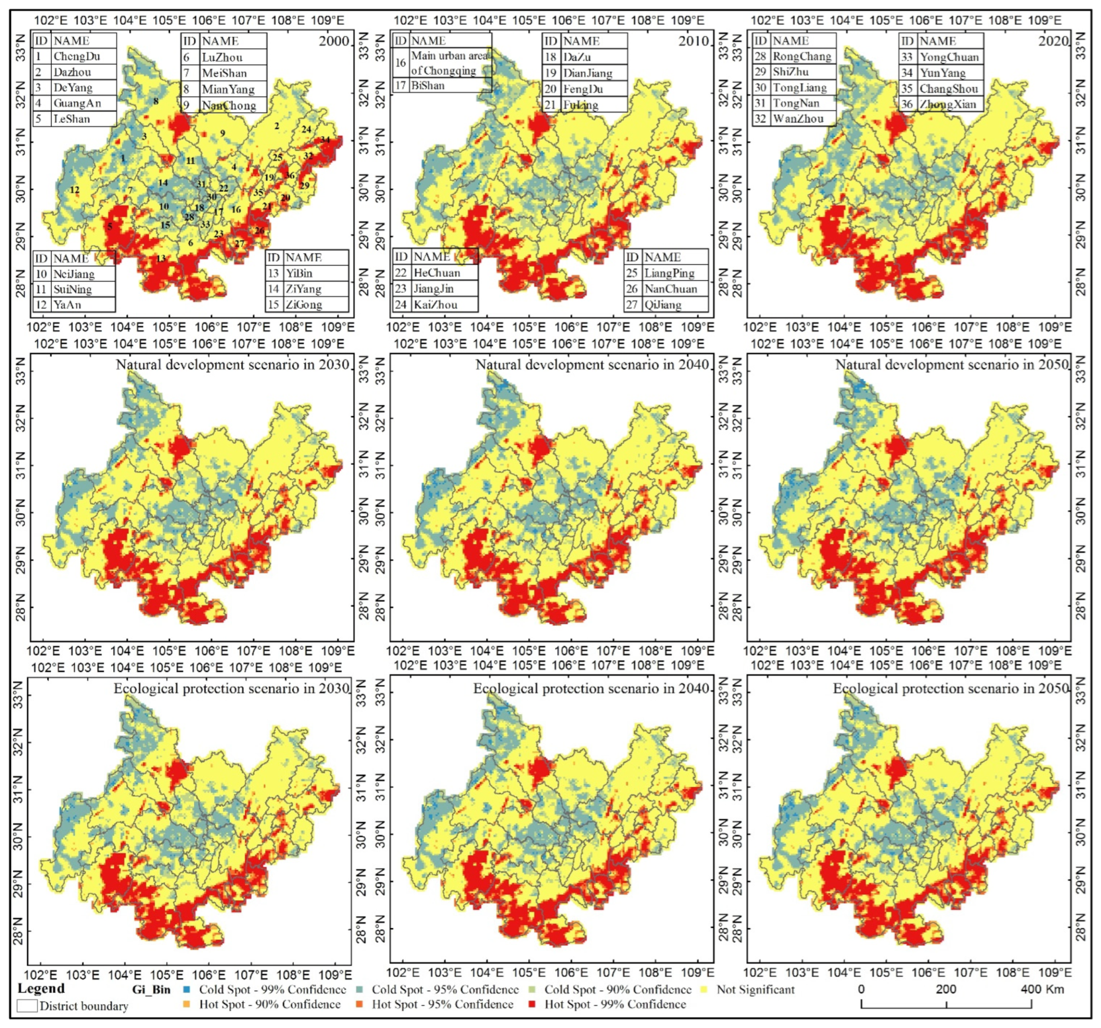
3.5. Hot Spot Analysis of LER
3.6. Analysis of the Grade Evolutionary Trends for LER from 2000 to 2050
3.6.1. Overall Analysis of the Grade Evolutionary Trends for LER in the C-C E Zone
3.6.2. Evolutionary Trend Analysis of the LER Levels in Various Regions
3.6.3. Analysis of the LER Rates of Change in Various Regions
3.6.4. Analysis of the Evolutionary Trends for LER Levels at the Grid Scale
4. Discussion
4.1. The High-Precision Simulation Effect of the PLUS Model over a Wide Area Was Conducive to Analyzing Evolutionary Trends in LER
4.2. Determination of the Ecological Grid Size Should Not Directly Refer to the Previous Research
4.3. Development Scenario Research Will Help Reduce LER in the Future
4.4. LER Can Explain Regional Ecological Risk at the Landscape Level
5. Conclusions
Author Contributions
Funding
Institutional Review Board Statement
Informed Consent Statement
Data Availability Statement
Conflicts of Interest
References
- Li, X.; Li, S.; Zhang, Y.; Connor, P.J.O.; Zhang, L.W.; Yan, J.P. Landscape Ecological Risk Assessment under Multiple Indicators. Land 2021, 10, 739. [Google Scholar] [CrossRef]
- Wu, Y.; Liu, H.; He, H. Stressors of dual-qualification nursing teachers in the ChengDu-ChongQing economic zone of China-a qualitative study. Nurse Educ. Today 2013, 33, 1496–1500. [Google Scholar] [CrossRef] [PubMed]
- Zhang, X.H.; Tao, H.; Wang, Y.J.; Ma, Z.Y.; Zhou, Z.Y. Pollution Characteristics and Risk Assessment of Tetracycline Antibiotics in Farmland Soil in Yinchuan. Environ. Sci. 2021, 42, 4933–4941. [Google Scholar]
- Wee, S.Y.; Omar, T.F.T.; Aris, A.Z.; Lee, Y. Surface Water Organophosphorus Pesticides Concentration and Distribution in the Langat River, Selangor, Malaysia. Expo. Health 2016, 8, 497–511. [Google Scholar] [CrossRef]
- Cui, L.; Zhao, Y.H.; Liu, J.C.; Han, L.; Ao, Y.; Yin, S. Landscape ecological risk assessment in Qinling Mountain. Geol. J. 2018, 53, 342–351. [Google Scholar] [CrossRef]
- Mondal, B.; Sharma, P.; Kundu, D.; Bansal, S. Spatio-temporal Assessment of Landscape Ecological Risk and Associated Drivers: A Case Study of Delhi. Environ. Urban. Asia 2021, 12, S85–S106. [Google Scholar] [CrossRef]
- Hunsaker, C.T.; Graham, R.L.; Suter, G.W.; Oneill, R.V.; Barnthouse, L.W.; Gardner, R.H. Assessing Ecological Risk on a Regional Scale. Environ. Manag. 1990, 14, 325–332. [Google Scholar] [CrossRef]
- Kityuttachai, K.; Tripathi, N.; Tipdecho, T.; Shrestha, R. CA-Markov analysis of constrained coastal urban growth modeling: Hua Hin seaside city. Sustainability 2013, 5, 1480–1500. [Google Scholar] [CrossRef] [Green Version]
- Kucsicsa, G.; Popovici, E.A.; Bălteanu, D.; Grigorescu, I.; Dumitraşcu, M.; Mitrică, B. Future land use/cover changes in romania: Regional simulations based on clue-s model and corine land cover database. Landsc. Ecol. Eng. 2019, 15, 75–90. [Google Scholar] [CrossRef]
- Liu, X.J.; Li, X.; Liang, X.; Shi, H.; Ou, J.P. Simulating the Change of Terrestrial Carbon Storage in China Based on the FLUS-InVEST Model. Trop. Geogr. 2019, 39, 397–409. [Google Scholar]
- Wu, D.; Zhu, K.W.; Zhang, S.; Huang, C.Q.; Li, J. Evolution Analysis of Carbon Storage in Chengdu-Chongqing Economic Zone Based on PLUS Model and InVEST Model. Ecol. Environ. Monit. Three Gorges 2021, 7, 1–18. [Google Scholar]
- Liang, X.; Liu, X.P.; Chen, G.L.; Leng, J.Y.; Wen, Y.Y.; Chen, G.Z. Coupling fuzzy clustering and cellular automata based on local maxima of development potential to model urban emergence and expansion in economic development zones. Int. J. Geogr. Inf. Sci. 2020, 34, 1930–1952. [Google Scholar] [CrossRef]
- Liang, X.; Guan, Q.F.; Clarke, K.C.; Liu, S.S.; Wang, B.Y.; Yao, Y. Understanding the drivers of sustainable land expansion using a patch-generating land use simulation (PLUS) model: A case study in Wuhan, China. Comput. Environ. Urban Syst. 2021, 85, 101569. [Google Scholar] [CrossRef]
- He, J.; Wu, L.J.; Zhang, L.X.; Chen, M.M. Landscape ecological risk assessment of ’Three Gorges Reservoir Area Based on Ecological Community. Ecol. Environ. Monit. Three Gorges 2022, 25, 1–19. [Google Scholar]
- Zeng, C.; He, J.; He, Q.Q.; Mao, Y.Q.; Yu, B.Y. Assessment of Land Use Pattern and Landscape Ecological Risk in the ChengduChongqing Economic Circle, Southwestern China. Land 2022, 11, 659. [Google Scholar] [CrossRef]
- Liu, J.Y.; Ning, J.; Kuang, W.H.; Xu, X.L.; Zhang, S.W.; Yan, C.Z.; Li, R.D.; Wu, S.X.; Hu, Y.F.; Du, G.M.; et al. Spatio-temporal patterns and characteristics of land-use change in China during 2010–2015. Acta Geogr. Sin. 2018, 73, 789–802. [Google Scholar]
- Wang, F.; Ye, C.S.; Hua, J.Q.; Li, X. Coupling Relationship between Urban Spatial Expansion and Landscape Ecological Risk in Nanchang City. Acta Ecol. Sin. 2019, 39, 1248–1262. [Google Scholar]
- Bai, S.T. Study on Landscape Ecological Risk Assessment of Western Jilin Based on Land Use Change. Master’s Thesis, Jilin University, Jilin, China, 2019. [Google Scholar]
- Du, J.; Zhao, S.C.; Qiu, S.K.; Guo, L. Land use change and landscape ecological risk assessment in loess hilly region of western Henan Province from 2000 to 2015. Res. Soil Water Conserv. 2021, 28, 279–284. [Google Scholar]
- Hou, R.; Li, H.B.; Gao, Y.L. Ecological risk assessment of land use in Jiangxia district of Wuhan based on landscape pattern. Res. Soil Water Conserv. 2021, 28, 323–330. [Google Scholar]
- Shen, H.C.; Xue, L.Q. Landscape Ecological Risk Assessment of the Lower Reaches of Tarim River Based on Land Use Change in Recent 20 Years. China Rural. Water Hydropower 2020, 11, 77–82. [Google Scholar]
- Qing, Q.L.; Huang, Y.; Pei, C. Eco-risk assessment and management based on landscape structure changes—A case study of Wanzhou district of Chongqing. J. Southwest Univ. 2021, 43, 174–184. [Google Scholar]
- Yang, K.; Xin, G.X.; Jiang, H.Y.; Yang, C.X. Study on spatiotemporal changes of landscape ecological risk based on the optimal spatial scale: A case study of Jiangjin district, Chongqing city. J. Ecol. Rural. Environ. 2021, 37, 576–586. [Google Scholar]
- Rangel-Buitrago, N.; Neal, W.J.; de Jonge, V.N. Risk assessment as tool for coastal erosion management. Ocean. Coast. Manag. 2020, 186, 105099. [Google Scholar] [CrossRef]
- Lou, N.; Wang, Z.J.; He, S.T. Assessment on Ecological Risk of Aha Lake National Wetland Park Based on Landscape Pattern. Res. Soil Water Conserv. 2020, 27, 233–239. [Google Scholar]
- Cui, Y.L.; Gao, X.; Dong, B.; Wei, H.M. Landscape ecological risk assessment of county. J. Zhejiang AF Univ. 2021, 38, 541–551. [Google Scholar]
- Zhu, K.W.; Yang, Z.M.; Huang, L.; Chen, Y.C.; Zhang, S.; Xiong, H.L.; Wu, S.; Lei, B. Coupling ITO3dE model and GIS for spatiotemporal evolution analysis of agricultural non-point source pollution risks in Chongqing in China. Sci. Rep. 2021, 11, 1–18. [Google Scholar] [CrossRef]
- Islam, S.; Li, Y.C.; Ma, M.G.; Chen, A.X.; Ge, Z.X. Simulation and Prediction of the Spatial Dynamics of Land Use Changes Modelling Through CLUE-S in the Southeastern Region of Bangladesh. J. Indian Soc. Remote Sens. 2021, 49, 2755–2777. [Google Scholar] [CrossRef]
- Hu, Y.C.; Zheng, Y.M.; Zheng, X.Q. Simulation of land-use scenarios for Beijing using CLUE-S and Markov composite models. Chin. Geogr. Sci. 2013, 23, 92–100. [Google Scholar] [CrossRef]
- Zhao, D.L.; Du, M.; Yang, J.Y.; Li, P.S.; He, S.S.; Zhu, D.H. Simulation and Forecast Study of Land Use Change Based on CA-Markov Model. Trans. Chin. Soc. Agric. Mach. 2016, 47, 278–285. [Google Scholar]
- Yu, T.; Bao, A.; Xu, W.; Guo, H.; Jiang, L.; Zheng, G. Exploring variability in landscape ecological risk and quantifying its driving factors in the amu darya delta. Int. J. Environ. Res. Public Health 2020, 17, 79. [Google Scholar] [CrossRef] [Green Version]
- Tian, P.; Li, J.; Gong, H.; Pu, R.; Liu, R. Research on land use changes and ecological risk assessment in yongjiang river basin in zhejiang province, china. Sustainability 2019, 11, 2817. [Google Scholar] [CrossRef] [Green Version]
- Chen, X.Q.; Ding, Z.Y.; Yang, J.; Chen, X.D.; Chen, M.N. Ecological risk assessment and driving force analysis of landscape in the compound mine-urban area of the northern Peixian County. Chin. J. Ecol. 2022, 41, 1–11. [Google Scholar]
- Xu, Q.; Guo, P.; Jin, M.; Qi, J. Multi-scenario landscape ecological risk assessment based on markov–flus composite model. Geomat. Nat. Hazards Risk 2021, 12, 1448–1465. [Google Scholar] [CrossRef]
- Tian, P.; Cao, L.; Li, J.; Pu, R.; Gong, H.; Li, C. Landscape characteristics and ecological risk assessment based on multi-scenario simulations: A case study of yancheng coastal wetland, China. Sustainability 2020, 13, 149. [Google Scholar] [CrossRef]
- Jian, Q.; Zhang, L.Q.; Zhang, P.T.; Zhao, L. Study on Landscape Ecological Risk Assessment and Spatial Differentiation of Qinglong Manchu Autonomous County Based on Explicit and Implicit Analysis. Res. Soil Water Conserv. 2018, 25, 228–235. [Google Scholar]
- Chen, Y.H.; Yu, J.; Nie, Y.; Tang, B.; Liu, C.C. Spatial Coupling Between Land Use Level and Landscape Ecological Risk—Taking Shiyan City as an Example. Res. Soil Water Conserv. 2021, 28, 285–291+2. [Google Scholar]
- Kang, Z.W.; Zhang, Z.Y.; Wei, H.; Liu, L.; Ning, S.; Zhao, G.N.; Wang, T.X.; Tian, H. Landscape ecological risk assessment in Manas River Basin based on land use change. Acta Ecol. Sin. 2020, 40, 6472–6485. [Google Scholar]


| Research’s Regional | Area of Research’s Regional (Unit: km2) | Resolution of Land Use Data (Unit: m) | Size of Ecological Grid (Unit: km) |
|---|---|---|---|
| Nanchang, China [17] | 7402.36 | 30 | 3 × 3 |
| Western of Jilin, China [18] | 4.69 × 10⁴ | 30 | 3 × 3 |
| Western of Henan, China [19] | 2.71 × 10⁴ | 30 | 5 × 5 |
| District of Xiajiang, Wuhan, China [20] | 2018 | 30 | 2 × 2 |
| Lower reaches of Tarim River [21] | 1.28 × 10⁴ | 30 | 3 × 3 |
| District of Wanzhou, Chongqing, China [22] | 3456.55 | 50 | 2 × 2 |
| District of Jiangjin, Chongqing, China [23] | 3217.77 | 30 | 3 × 3 |
| Three Gorges Reservoir area [14] | 5.85 × 10⁴ | 30 | 4 × 4 |
| Level\Period | 2000 | 2010 | 2020 | ND Scenario | EP Scenario | ||||
|---|---|---|---|---|---|---|---|---|---|
| 2030 | 2040 | 2050 | 2030 | 2040 | 2050 | ||||
| No risk | 36.18 | 40.97 | 40.33 | 33.57 | 29.31 | 27.47 | 33.68 | 31.71 | 30.37 |
| Low risk | 24.13 | 22.67 | 23.16 | 27.6 | 29.12 | 30.06 | 27.34 | 28.59 | 29.43 |
| Medium risk | 17.34 | 17.26 | 16.87 | 18.12 | 20.02 | 20.13 | 18.36 | 18.68 | 19.44 |
| High risk | 14.21 | 13.47 | 13.75 | 14.26 | 14.52 | 14.67 | 14.26 | 14.36 | 14.33 |
| Extremely high risk | 8.14 | 5.63 | 5.89 | 6.45 | 7.03 | 7.67 | 6.36 | 6.66 | 6.43 |
| Region\Period | 2000 | 2010 | 2020 | ND Scenario | EP Scenario | ||||
|---|---|---|---|---|---|---|---|---|---|
| 2030 | 2040 | 2050 | 2030 | 2040 | 2050 | ||||
| Chengdu | 1.93 | 1.93 | 2.02 | 2.89 | 4.34 | 5 | 2.76 | 3.37 | 3.53 |
| Dazhou | 1.77 | 1.32 | 1.55 | 1.75 | 2.15 | 2.52 | 1.74 | 1.86 | 1.81 |
| Deyang | 11.26 | 11.65 | 11.46 | 12 | 12.45 | 12.98 | 11.89 | 12.19 | 12.01 |
| Guangan | 7.12 | 5.23 | 4.63 | 5.42 | 5.92 | 6.39 | 5.33 | 5.61 | 5.25 |
| Leshan | 47.4 | 47.09 | 47.1 | 48.31 | 49.68 | 52.64 | 48.17 | 49.01 | 47.96 |
| Luzhou | 62.4 | 52.33 | 55.32 | 56.65 | 57.64 | 59.32 | 56.37 | 56.98 | 56.5 |
| Meishan | 3.51 | 4.12 | 4.09 | 4.32 | 5.09 | 5.51 | 4.29 | 4.5 | 4.8 |
| Mianyang | 12.57 | 10.92 | 11.2 | 12.59 | 13.45 | 13.95 | 12.8 | 12.89 | 12.59 |
| Nanchong | 4.71 | 2.45 | 2.49 | 2.77 | 2.84 | 2.98 | 2.72 | 2.81 | 2.62 |
| Neijiang | 5.84 | 6.1 | 6.11 | 6.33 | 6.84 | 7.22 | 6.31 | 6.49 | 6.39 |
| Suining | 0.88 | 0.69 | 0.8 | 0.79 | 0.81 | 0.9 | 0.78 | 0.8 | 0.81 |
| Yaan | 0.36 | 0 | 0 | 0 | 0 | 0 | 0 | 0 | 0 |
| Yibin | 79.16 | 77.68 | 78.4 | 80.74 | 82.41 | 83.37 | 80.64 | 81.41 | 81.25 |
| Ziyang | 0.56 | 0.53 | 0.58 | 1.11 | 1.44 | 1.88 | 1 | 1.13 | 1.18 |
| Zigong | 10.65 | 10.83 | 11.04 | 11.51 | 11.81 | 12.37 | 11.42 | 11.59 | 11.52 |
| Main urban area of Chongqing | 21.7 | 18.83 | 19.99 | 22.97 | 23.69 | 24.43 | 22.91 | 23.12 | 23.1 |
| Bishan | 0 | 0 | 0 | 0 | 0 | 0 | 0 | 0 | 0 |
| Dazu | 0 | 0 | 0 | 0 | 0 | 0 | 0 | 0 | 0 |
| Dianjiang | 9.57 | 3.72 | 3.39 | 6.75 | 7.87 | 9.16 | 6.1 | 7.15 | 5.66 |
| Fengdu | 42.81 | 35.02 | 43.38 | 46.72 | 49.48 | 52.78 | 46.04 | 47.83 | 46.37 |
| Fuling | 58.68 | 59.31 | 61.65 | 68.1 | 72.11 | 74.66 | 67.74 | 69.3 | 68.15 |
| Hechuan | 0 | 0 | 0 | 0 | 0 | 0 | 0 | 0 | 0 |
| Jiangjin | 46.82 | 41.83 | 42.5 | 43.26 | 44.72 | 45.53 | 43.33 | 43.87 | 43.91 |
| Kaizhou | 3.87 | 0.03 | 0.06 | 0.1 | 0.13 | 0.2 | 0.09 | 0.11 | 0.1 |
| Liangping | 19.54 | 10.93 | 12.23 | 13.84 | 12.83 | 13.24 | 13.46 | 14.21 | 12.3 |
| Nanchuan | 91.18 | 81.23 | 85.23 | 87.82 | 89.49 | 91.32 | 87.21 | 88.61 | 88.44 |
| Qijiang | 80.32 | 77.21 | 78.66 | 82.97 | 84.77 | 86.92 | 82.63 | 83.89 | 82.7 |
| Rongchang | 0 | 0 | 0 | 0 | 0 | 0 | 0 | 0 | 0 |
| Shizhu | 23.11 | 0.26 | 0.19 | 0.22 | 0.35 | 0.63 | 0.22 | 0.29 | 0.32 |
| Tongliang | 0 | 0 | 0 | 0 | 0 | 0 | 0 | 0 | 0 |
| Tongnan | 0 | 0 | 0 | 0 | 0 | 0 | 0 | 0 | 0 |
| Wanzhou | 50.64 | 12.91 | 14.48 | 15.64 | 17.07 | 18.23 | 15.5 | 16.17 | 15.54 |
| Yongchuan | 0 | 0 | 0 | 0 | 0 | 0 | 0 | 0 | 0 |
| Yunyang | 59.84 | 33.21 | 31.91 | 33.07 | 35.82 | 36.39 | 32.71 | 33.91 | 33.5 |
| Changshou | 14.14 | 12.3 | 9.32 | 17.46 | 21.65 | 24.06 | 16.41 | 19.03 | 17.65 |
| Zhongxian | 33.98 | 22.68 | 25.46 | 26.7 | 28.51 | 30.1 | 26.26 | 27.06 | 26.75 |
| C-C E Zone | 22.35 | 19.1 | 19.65 | 20.71 | 21.55 | 22.34 | 20.62 | 21.02 | 20.76 |
| Region\Period | 2000–2010 | 2010–2020 | ND Scenario | EP Scenario | ||||
|---|---|---|---|---|---|---|---|---|
| 2020–2030 | 2030–2040 | 2040–2050 | 2020–2030 | 2030–2040 | 2040–2050 | |||
| Chengdu | 0 | 0.009 | 0.087 | 0.145 | 0.066 | 0.074 | 0.061 | 0.016 |
| Dazhou | −0.045 | 0.023 | 0.02 | 0.04 | 0.037 | 0.019 | 0.012 | −0.005 |
| Deyang | 0.039 | −0.019 | 0.054 | 0.045 | 0.053 | 0.043 | 0.03 | −0.018 |
| Guangan | −0.189 | −0.06 | 0.079 | 0.05 | 0.047 | 0.07 | 0.028 | −0.036 |
| Leshan | −0.031 | 0.001 | 0.121 | 0.137 | 0.296 | 0.107 | 0.084 | −0.105 |
| Luzhou | −1.007 | 0.299 | 0.133 | 0.099 | 0.168 | 0.105 | 0.061 | −0.048 |
| Meishan | 0.061 | −0.003 | 0.023 | 0.077 | 0.042 | 0.02 | 0.021 | 0.03 |
| Mianyang | −0.165 | 0.028 | 0.139 | 0.086 | 0.05 | 0.16 | 0.009 | −0.03 |
| Nanchong | −0.226 | 0.004 | 0.028 | 0.007 | 0.014 | 0.023 | 0.009 | −0.019 |
| Neijiang | 0.026 | 0.001 | 0.022 | 0.051 | 0.038 | 0.02 | 0.018 | −0.01 |
| Suining | −0.019 | 0.011 | −0.001 | 0.002 | 0.009 | −0.002 | 0.002 | 0.001 |
| Yaan | −0.036 | 0 | 0 | 0 | 0 | 0 | 0 | 0 |
| Yibin | −0.148 | 0.072 | 0.234 | 0.167 | 0.096 | 0.224 | 0.077 | −0.016 |
| Ziyang | −0.003 | 0.005 | 0.053 | 0.033 | 0.044 | 0.042 | 0.013 | 0.005 |
| Zigong | 0.018 | 0.021 | 0.047 | 0.03 | 0.056 | 0.038 | 0.017 | −0.007 |
| Main urban area of Chongqing | −0.287 | 0.116 | 0.298 | 0.072 | 0.074 | 0.292 | 0.021 | −0.002 |
| Bishan | 0 | 0 | 0 | 0 | 0 | 0 | 0 | 0 |
| Dazu | 0 | 0 | 0 | 0 | 0 | 0 | 0 | 0 |
| Dianjiang | −0.585 | −0.033 | 0.336 | 0.112 | 0.129 | 0.271 | 0.105 | −0.149 |
| Fengdu | −0.779 | 0.836 | 0.334 | 0.276 | 0.33 | 0.266 | 0.179 | −0.146 |
| Fuling | 0.063 | 0.234 | 0.645 | 0.401 | 0.255 | 0.609 | 0.156 | −0.115 |
| Hechuan | 0 | 0 | 0 | 0 | 0 | 0 | 0 | 0 |
| Jiangjin | −0.499 | 0.067 | 0.076 | 0.146 | 0.081 | 0.083 | 0.054 | 0.004 |
| Kaizhou | −0.384 | 0.003 | 0.004 | 0.003 | 0.007 | 0.003 | 0.002 | −0.001 |
| Liangping | −0.861 | 0.13 | 0.161 | −0.101 | 0.041 | 0.123 | 0.075 | −0.191 |
| Nanchuan | −0.995 | 0.4 | 0.259 | 0.167 | 0.183 | 0.198 | 0.14 | −0.017 |
| Qijiang | −0.311 | 0.145 | 0.431 | 0.18 | 0.215 | 0.397 | 0.126 | −0.119 |
| Rongchang | 0 | 0 | 0 | 0 | 0 | 0 | 0 | 0 |
| Shizhu | −2.285 | −0.007 | 0.003 | 0.013 | 0.028 | 0.003 | 0.007 | 0.003 |
| Tongliang | 0 | 0 | 0 | 0 | 0 | 0 | 0 | 0 |
| Tongnan | 0 | 0 | 0 | 0 | 0 | 0 | 0 | 0 |
| Wanzhou | −3.773 | 0.157 | 0.116 | 0.143 | 0.116 | 0.102 | 0.067 | −0.063 |
| Yongchuan | 0 | 0 | 0 | 0 | 0 | 0 | 0 | 0 |
| Yunyang | −2.663 | −0.13 | 0.116 | 0.275 | 0.057 | 0.08 | 0.12 | −0.041 |
| Changshou | −0.184 | −0.298 | 0.814 | 0.419 | 0.241 | 0.709 | 0.262 | −0.138 |
| Zhongxian | −1.13 | 0.278 | 0.124 | 0.181 | 0.159 | 0.08 | 0.08 | −0.031 |
| C-C E Zone | −0.325 | 0.055 | 0.106 | 0.084 | 0.079 | 0.097 | 0.04 | −0.026 |
Publisher’s Note: MDPI stays neutral with regard to jurisdictional claims in published maps and institutional affiliations. |
© 2022 by the authors. Licensee MDPI, Basel, Switzerland. This article is an open access article distributed under the terms and conditions of the Creative Commons Attribution (CC BY) license (https://creativecommons.org/licenses/by/4.0/).
Share and Cite
Zhu, K.; He, J.; Zhang, L.; Song, D.; Wu, L.; Liu, Y.; Zhang, S. Impact of Future Development Scenario Selection on Landscape Ecological Risk in the Chengdu-Chongqing Economic Zone. Land 2022, 11, 964. https://0-doi-org.brum.beds.ac.uk/10.3390/land11070964
Zhu K, He J, Zhang L, Song D, Wu L, Liu Y, Zhang S. Impact of Future Development Scenario Selection on Landscape Ecological Risk in the Chengdu-Chongqing Economic Zone. Land. 2022; 11(7):964. https://0-doi-org.brum.beds.ac.uk/10.3390/land11070964
Chicago/Turabian StyleZhu, Kangwen, Jun He, Lanxin Zhang, Dan Song, Longjiang Wu, Yaqun Liu, and Sheng Zhang. 2022. "Impact of Future Development Scenario Selection on Landscape Ecological Risk in the Chengdu-Chongqing Economic Zone" Land 11, no. 7: 964. https://0-doi-org.brum.beds.ac.uk/10.3390/land11070964