
Soil and Water Conservation Strategies in Cape Verde (Cabo Verde in Portuguese) and Their Impacts on Livelihoods: An Overview from the Ribeira Seca Watershed


 ,
,  ,
,
Abstract
:1. Introduction
2. Methods
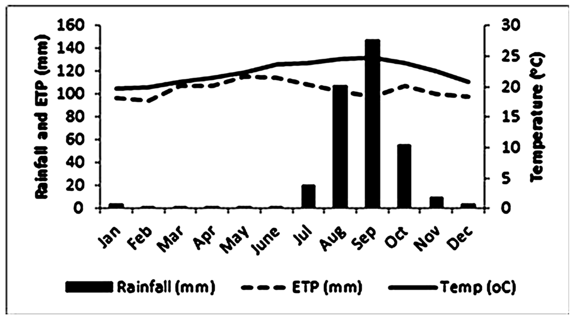
2.1. Study Area
2.1.1. Cape Verde Natural Resource Endowment
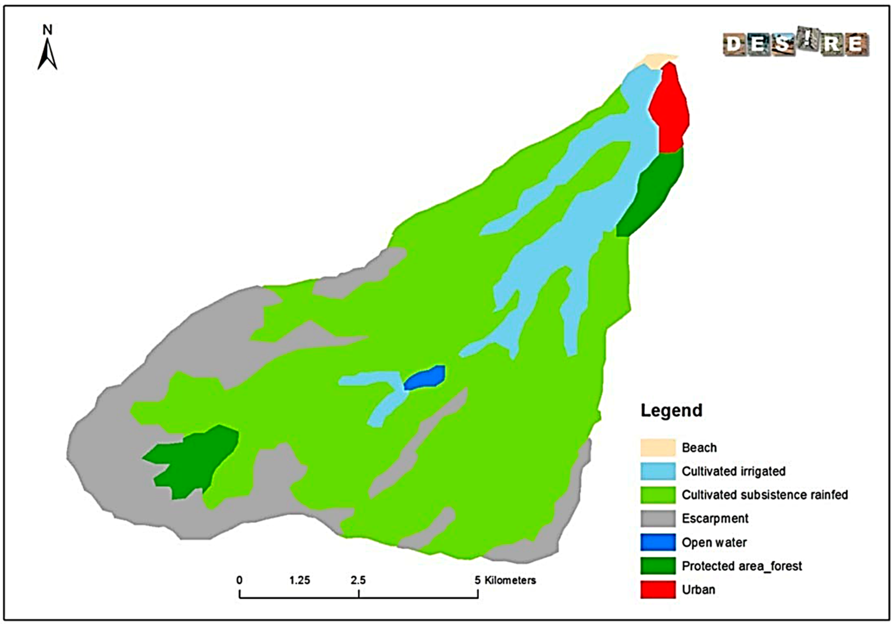
2.1.2. Ribeira Seca Watershed: The Largest Watershed in Santiago Island


2.2. Methodological Approach
3. Building Resilience to Challenge the Harsh Conditions: SLM Governance Factors
3.1. Eradicating Famine
3.2. Environmental Awareness and Actions
- From 1975 to 1985, participation of the population was achieved through FAIMO, which were institutionalized employment schemes that provided people with temporary paid work to alleviate their immediate household needs. The employment scheme and the top-down approach created their own dynamics: while successful in mobilizing the participation of land users, they led to a lack of perceived responsibility by landowners to maintain the structures [25], with consequences for the effectiveness of environmental conservation [26].
- From 1985 to 1995, in an attempt to change the concept of FAIMO by diversifying rural livelihood sources and introducing more participation of local people, there was some involvement of the stakeholders, particularly land users. However, it was not an effective participation since the approach did not emphasize participation as a process. Stakeholders’ participation, as a process, needs to be supported by an approach that emphasizes empowerment, fairness, trust, and learning [28]. Thus, this can be considered a transitional phase to an effective stakeholders’ participation.
- From the late 1990’s onwards, the ratification of the UNCCD harnessed the participation of local communities in drawing up a national action program to combat desertification (PAN-LCD). Since then, a full partnership with the population has been established, with community-based organizations playing a major role not only in implementing and maintaining SWC works, but also in contributing local knowledge and choosing the best local measures.
4. Drivers of Land Degradation and Desertification
5. Status of Land Resources and Management
5.1. Monitoring and Assessment in the Ribeira Seca Watershed
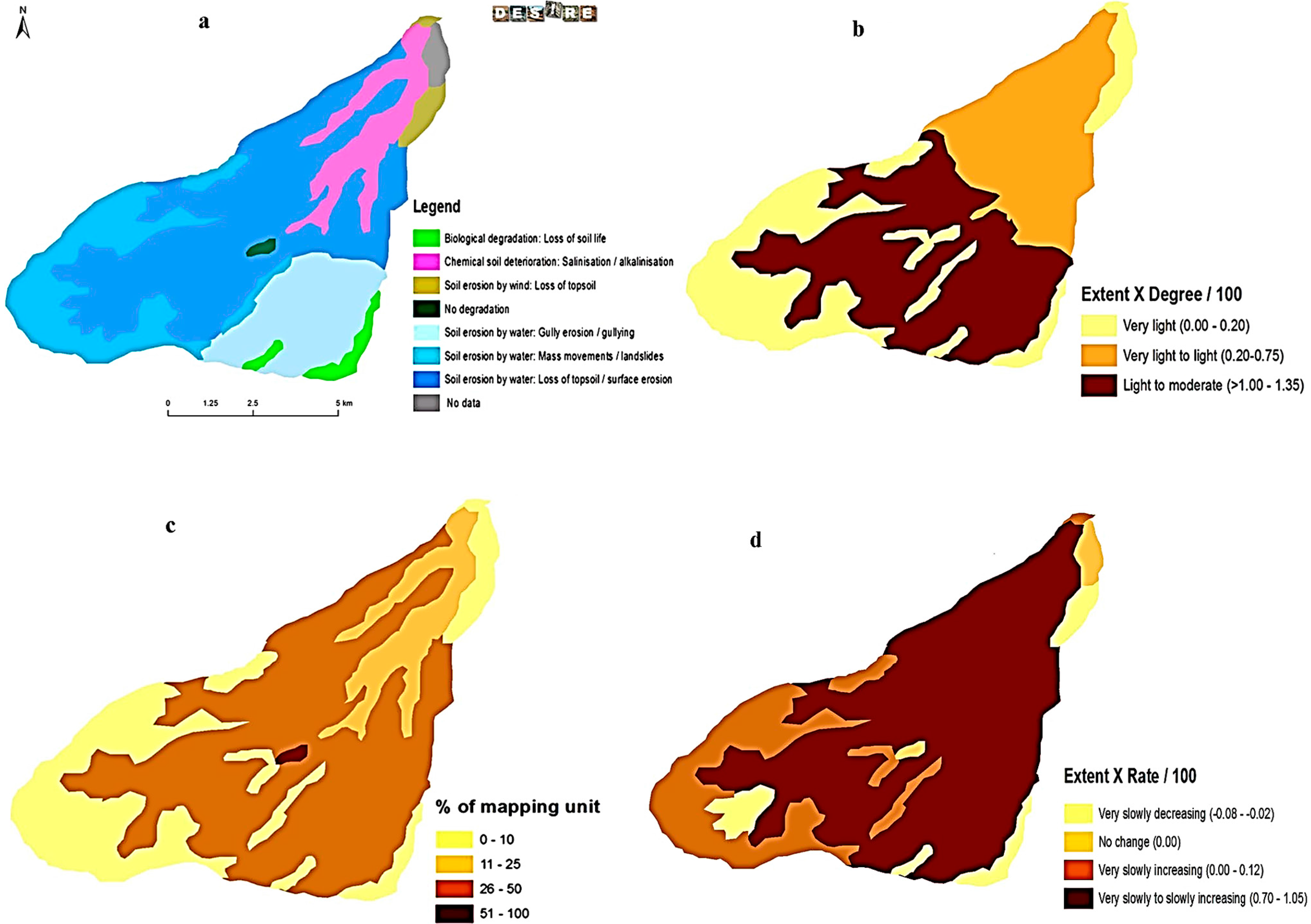
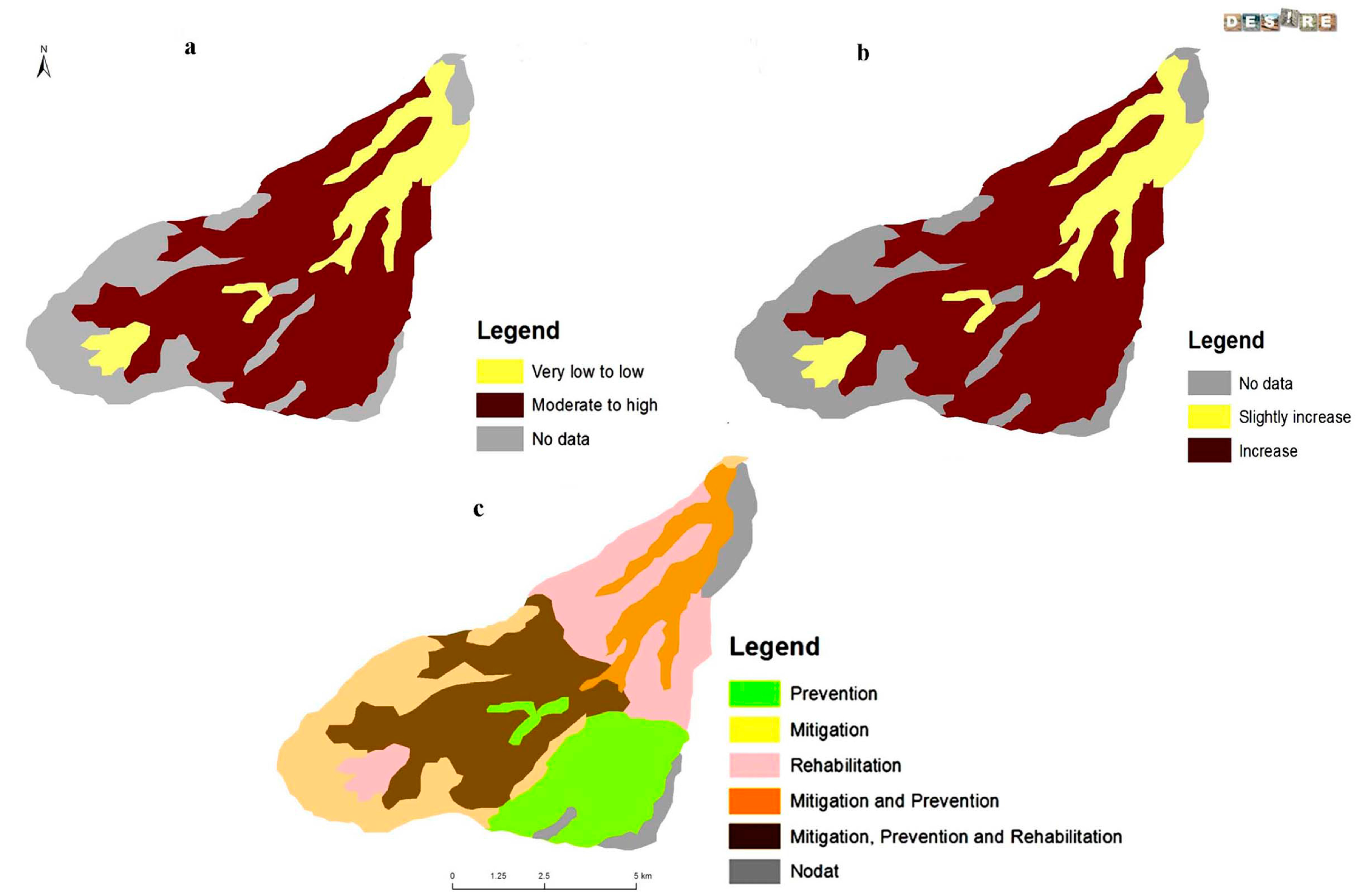
5.2. Type, Degree, Extent and Trend of Land Degradation and Desertification Risk

5.3. Magnitude of Soil Erosion

| Scale/Location/% Slope | Period of Measurements | Land Use/Conservation Measure | Magnitude (t·ha−1·yr−1) | Reference |
|---|---|---|---|---|
| Sub-watershed: Seca (variable slopes) | 1985–1989 | Mixed land-use/Check dams | 4.66 | [39] |
| Sub-watershed: Longueira (variable slopes) | 2005–2009 | Mixed land-use and conservation measures | 42.7 | [42] |
| Sub-watershed/Grande/variable slopes | 1.57 | |||
| Sub-watershed: Godim/variable slopes | 0.10 | |||
| Plot/O. Pequeno/≤37 | 2011–2012 | Maize and beans | 9.10 (16.6) * | [37] |
| Plot/Serrado/≤23 | 2.13 (3.21) * | |||
| Plot/S. Jorge/≤8 | 0.30 (0.4) * | |||
| Plot/Godim)/50 | 1994–1996 | Maize and beans | 16.0 (48) ** | [2] |
| Plot/Godim/35–60 | Maize and beans | 23 (69) ** | [26] |
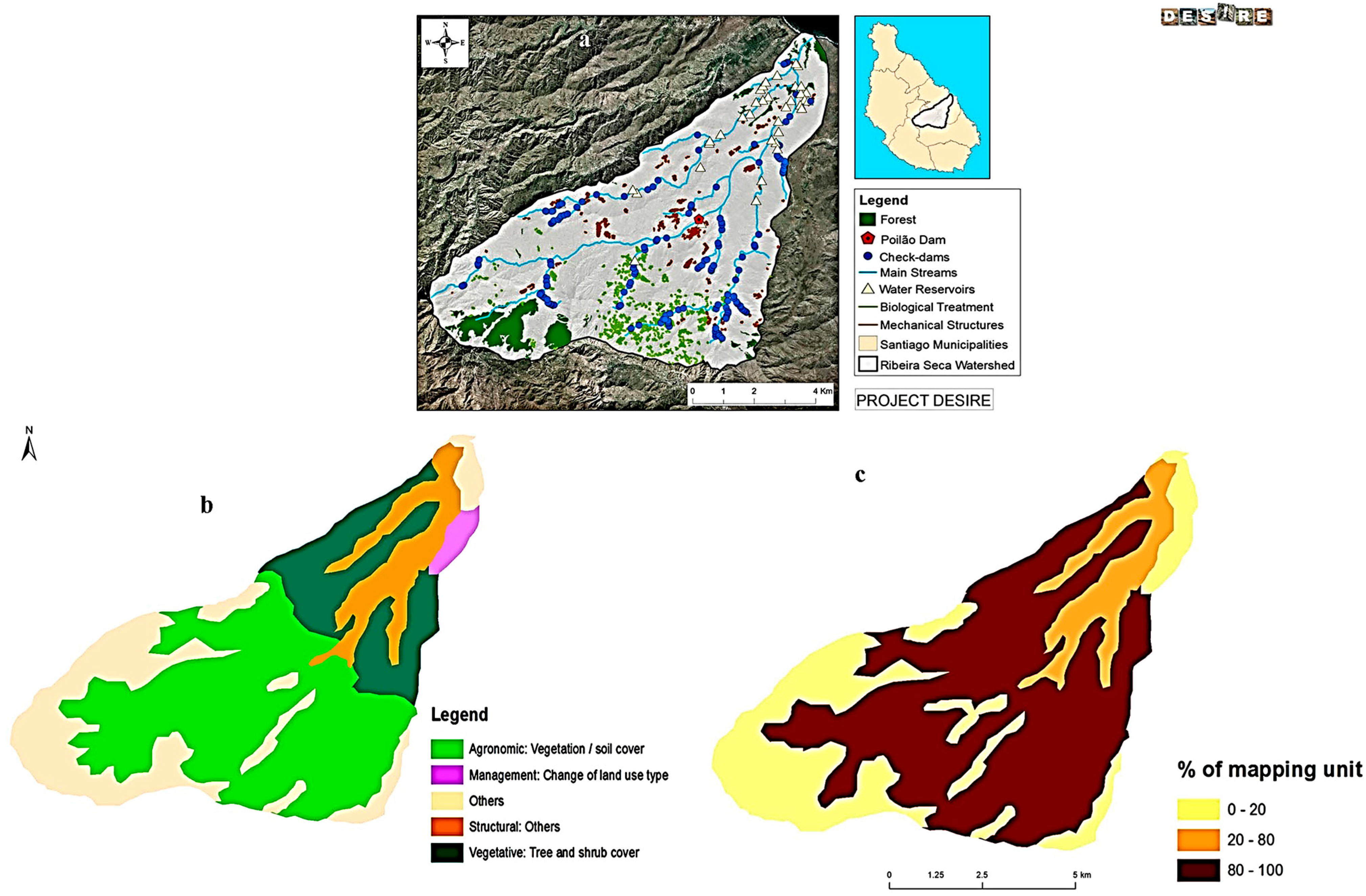
5.4. Existing Land Management Measures


6. Effectiveness and Impact of SWC
6.1. Effectiveness for Slope Protection and Soil Cover

6.2. Impact on Crop Yield
| Parameter | Before Technology | Year 1 | Year 2 |
|---|---|---|---|
| Soil cover (%) | <1 | 35 | 48–87 |
| Dry organic mulch (%) | <5 | 31 | 60 |
| Grain yield (t∙ha−1) | <0.2 | 1.9 | 1.8 |
| Biomass (% increase) | 115 |
7. Sustainable Rural Livelihood
7.1. Livelihood Approach to Soil and Water Conservation
7.2. Cultural Value of Rain-Fed Crops
7.3. Importance of Dryland Production for Rural Family Food Security
8. Policy Oriented Recommendations
9. Conclusions
Acknowledgments
Author Contributions
Conflict of Interest
References
- Ferreira, A.D.F.; Tavares, J.; Baptista, I.; Coelho, C.O.A.; Reis, A.; Varela, L.; Bentub, J. Efficiency of overland and erosion mitigation techniques at Ribeira Seca, Santiago Island, Cape Verde. In Overland Flow and Surface Runoff; Hydrological Science and Engineering Book Series; Wong, T.S.W., Ed.; Nova Science Publishers, Inc.: Singapore, 2013; pp. 113–135. [Google Scholar]
- Smolikowski, B.; Puig, H.; Roose, E. Influence of soil protection techniques on runoff, erosion and plant production on semi-arid hillsides of Cabo Verde. Agric. Ecosyst. Environ. 2001, 87, 67–80. [Google Scholar] [CrossRef]
- Direcção Geral do Ambiente (DGA). PANAII—Segundo Plano de Acção Nacional para o Ambiente (2004–2014); Ministério do Ambiente, Agricultura e Pescas: Praia, Cape Verde, 2004. [Google Scholar]
- Cowie, A.L.; Penman, T.D.; Gorissen, L.; Winslow, M.D.; Lehmann, J.; Tyrrell, T.D.; Twomlow, S.; Wilkes, A.; Lal, R.; Jones, J.W.; et al. Towards sustainable land management in the drylands: Scientific connections in monitoring and assessing dryland degradation, climate change and biodiversity. Land Degrad. Dev. 2011, 22, 248–260. [Google Scholar] [CrossRef]
- World Overview of Conservation Approaches and Technologies (WOCAT). Where the Land is Greener—Case Studies and Analysis of Soil and Water Conservation Initiatives Worldwide; Liniger, H.P., Critchley, W., Eds.; Technical Centre for Agriculture and Rural Cooperation (CTA): Wageningen, The Netherlands; Food and Agriculture Organization (FAO): Rome, Italy; United Nations Environment Programme (UNEP): Nairobi, Kenya; Centre for Development and Environment (CDE), University of Berne: Berne, Switzerland, 2007. [Google Scholar]
- Schwilch, G.; Bachmann, F.; Liniger, H.P. Appraising and selecting conservation measures to mitigate desertification and land degradation based on stakeholder participation and global best practices. Land Degrad. Dev. 2009, 20, 308–326. [Google Scholar] [CrossRef]
- United Nations University (UNU-INWEH). Guidelines for the Preparations and Reporting on Globally Relevant SLM Impact Indicators for Project Level Monitoring; UNU-INWEH: Hamilton, ON, Canada, 2011. [Google Scholar]
- Schwilch, G.; Hessel, R.; Verzandvoort, S. (Eds.) Desire for Greener Land. Options for Sustainable Land Management in Drylands; Centre for Development and Environment, University of Bern (CDE): Bern, Switzerland; ALTERRA-Wageningen UR, World Soil Information (ISRIC) and Technical Centre for Agriculture and Rural Cooperation (CTA): Wageningen, The Netherlands, 2012.
- Moreno, A.; Pereira, L.S. As obras de engenharia rural e os seus impactos nos recursos hídricos em Cabo Verde; 7ª Silusba da APRH: Evora, Portugal, 2005. [Google Scholar]
- Tavares, J.; Ferreira, A.J.D.; Reis, E.A.; Baptista, I.; Amoros, R.; Costa, L.; Furtado, A.M.; Coelho, C. Appraising and selecting strategies to combat and mitigate desertification based on stakeholder knowledge and global best practices in Cape Verde Archipelago. Land Degrad. Dev. 2013, 25, 45–57. [Google Scholar] [CrossRef]
- Langworthy, M.; Finan, T. Waiting for Rain: Agriculture and Ecological Imbalance in Cape Verde; Technology and Engineer Book; Lynne Rienner Publishers: Boulder, CO, USA, 1997; p. 212. [Google Scholar]
- Sanchez-Moreno, J.F.; Mannaerts, C.M.; Jetten, V. Influence of topography on rainfall variability in Santiago Island, Cape Verde. Int. J. Climatol. 2013. [Google Scholar] [CrossRef]
- Instituto Nacional de Gestão e Desenvolvimento dos Recursos Hídricos (INGRH). Plano de Acção Nacional para Gestão Integrada dos Recursos Hídricos—PAGIRE; INGRH Serie No 45, 2; República de Cabo Verde: Praia, Cape Verde, 2010. [Google Scholar]
- Diniz, A.C.; Matos, G.S. Carta de Zonagem Agro-ecológica e de Vegetação de Cabo Verde: I-Ilha de Santiago. Garcia da Orta; Serie de Botânica 1986, 8, 39–82. [Google Scholar]
- Instituto Nacional de Investigação e Desenvolvimento Agrário (INIDA). Manual de Fertilidade do solo e fertilização das culturas; Sociedade Astória, Lda: S. Jorge dos Órgãos, Cape Verde, 1997. [Google Scholar]
- Instituto Nacional de Investigação e Desenvolvimento Agrário-Desertification Mitigation and Remediation of Land (INIDA-DESIRE). Characterization of the Ribeira Seca Watershed—Santiago Island—Cape Verde Hotspot; Field Guide for the DESIRE 2nd Plenary Meeting; INIDA-DESIRE: Praia, Cape Verde, 2008. [Google Scholar]
- World Bank. World Development Report 2000/2001: Attacking Poverty; World Bank: Washington, DC, USA, 2000. [Google Scholar]
- DESIRE Project—Harmonised Information System: Providing Local Solutions to Global Sustainable Land Management Problems. Available online: http://www.desire-his.eu (accessed on 1 June 2014).
- World Overview of Conservation Approaches and Technologies (WOCAT). Questionnaires on SLM technologies and approaches (basic). In A Framework for the Evaluation of Sustainable Land Management (Revised); Liniger, H.P., Schwilch, G., Meckdachi Studer, R., Hauert, C., van Lynden, G., Critchley, W., Eds.; Centre for Development and Environment, Institute of Geography, University of Berne: Berne, Switzerland, 2008. [Google Scholar]
- World Overview of Conservation Approaches and Technologies (WOCAT). Available online: http://www.wocat.net (accessed on 1 June 2014).
- Aerial Photography and Imagery, Ortho-Corrected–2010 Digital Orthophotos–Lafayette County; Aerial Data Service, Inc.: Tulsa, OK, USA, 2010.
- Schwilch, G.; Bestelmeyer, B.; Bunning, S.; Critchley, W.; Herrick, J.; Kellner, K.; Liniger, H.P.; Nachtergaele, F.; Ritsema, C.J.; Schuster, B.; et al. Experiences in monitoring and assessment of sustainable land management. Land Degrad. Dev. 2011, 22, 214–225. [Google Scholar] [CrossRef]
- Lesourd, M. État et société aux îles du Cap-Vert. Collection «Hommes et Sociétés»; Éditions Karthala: Paris, France, 1995; p. 524. [Google Scholar]
- Amaral, I. Santiago de Cabo Verde: A terra e os Homens; Memórias da Junta de Investigação do Ultramar, segunda série, n°48; Universidade do Algarve: Faro, Portugal, 2007; p. 444. [Google Scholar]
- Haagsma, B.; Reij, C. Frentes de trabalho: Potentials and limitations of large scale labour employment for soil and water conservation in Cape Verde. Land Degrad. Dev. 1993, 4, 73–85. [Google Scholar] [CrossRef]
- Querido, A.L. Watershed System Analysis for Evaluating the Efficiency of Soil and Water Conservation Works: A Case Study in Ribeira Seca, Santiago Island, Cape Verde; Faculty of Geo-Information Science and Earth Observation, University of Twente (ITC): Enschede, The Netherlands, 1999. [Google Scholar]
- National Adaptation Programme of Action on Climate Change (NAPA 2008–2012); Global Environmental Fund/United Nations Development Programme (GEF/UNDP): Praia, Cape Verde, 2007.
- Pretty, J. Participatory learning for sustainable agriculture. World Dev. 1995, 23, 1247–1263. [Google Scholar] [CrossRef]
- Reed, M.S. Stakeholder participation for environmental management: A literature review. Biol. Conserv. 2008, 141, 2417–2431. [Google Scholar] [CrossRef]
- Mutekanga, F.P.; Kessler, A.; Leber, K.; Visser, S. The use of stakeholders’ analysis in integrated watershed management. Mt. Res. Dev. 2013, 33, 122–131. [Google Scholar] [CrossRef]
- Reed, M.S.; Fraser, E.D.G.; Morse, S.; Dougill, A.J. Integrating methods for developing sustainability indicators that can facilitate learning and action. Ecol. Soc. 2005, 10, r3. [Google Scholar]
- Reed, M.S.; Buenemann, M.; Atlhopheng, J.; Akhtar-Schuster, M.; Bachmann, F.; Bastin, G.; Bigas, H.; Chanda, R.; Dougill, A.J.; Essahli, W.; et al. Cross-scale monitoring and assessment of land degradation and sustainable land management: A methodological framework for knowledge management. Land Degrad. Dev. 2011, 22, 261–271. [Google Scholar] [CrossRef]
- Stringer, L.C.; Reed, M.S. Land degradation assessment in Southern Africa: Integrating local and scientific knowledge bases. Land Degrad. Dev. 2007, 18, 99–116. [Google Scholar] [CrossRef]
- Schwilch, G.; Bachmann, F.; de Graaff, J. Decision support for selecting SLM technologies with stakeholders. Appl. Geogr. 2012, 34, 86–98. [Google Scholar] [CrossRef]
- The Committee for Development Policy, Development Policy and Analysis Division, United Nations. Monitoring the progress of graduated countries—Cape Verde. In Proceedings of Expert Group Meeting for Review of the List of the Least Developed Countries, New York, NY, USA, 16–17 January 2011; 2011. CDP2012/PLEN/11. [Google Scholar]
- Tavares, J.; Amiotte-Suchet, P. Rainfall erosion risk mapping in volcanic soils of Santiago Island, Cape Verde Archipelago. Afr. Geosci. Rev. 2007, 14, 399–414. [Google Scholar]
- Baptista, I.; Ritsema, C.J.; Querido, A.; Ferreira, A.D.F.; Geissen, V. Improving rainwater-use in Cape Verde drylands by reducing runoff and erosion. Geoderma 2015, 237–238, 283–297. [Google Scholar] [CrossRef]
- Barry, O.; Smolikowski, B.; Roose, E. Bilan de la lutte anti-érosive dans les zones d’agriculture pluviale au Cap-Vert; un projet innovant, le PRODAP. Agric. Dév. CIRAD-CA 1995, 5, 57–68. [Google Scholar]
- Lopes, V.; Mayer, J. Watershed management program on Santiago Island, Cape Verde. Environ. Manag. 1993, 17, 51–57. [Google Scholar] [CrossRef]
- Mannaerts, C.M. Contribution à l’évaluation de l’érosion des sols au Cap Vert; Rapport Inédit; GCP/CVI/002/BEL.FAO; Food and Agriculture Organization (FAO): Rome, Italy, 1986; p. 43. [Google Scholar]
- Mannaerts, C.M. Assessment of the Transferability of Laboratory Rainfall—Runoff and Rainfall—Soil Loss Relationship to Field and Catchment Scales: A Study in the Cape Verde Islands. Ph.D. Thesis, University of Twente, Enschede, The Netherlands, 1993. [Google Scholar]
- Tavares, J. TavaresSoil Erosion in Cape Verde: A Study of Processes and Quantification at the Scale of Three Watersheds of the Santiago Island. Ph.D. Thesis, Bourgogne University, Dijon, France, 2010. [Google Scholar]
- Sabino, A. As estruturas de conservação do solo e água em Cabo Verde e a quantificação dos impactos na área do Watershed Development Project (Ilha de Santiago). In Proceedings of the 1as Jornadas sobre Agricultura de Cabo Verde, Comunicações do Instituto de Investigação Científica Tropical, Série de Ciências Agrárias, Lisboa, Portugal, 23–25 October 1990; 1990; pp. 91–124. [Google Scholar]
- Wakindiki, C.; Ben-Hur, M. Indigenous soil and water conservation techniques: Effects on runoff, erosion, and crop yields under semi-arid conditions. Aust. J. Soil Res. 2004, 40, 367–379. [Google Scholar] [CrossRef]
- Liniger, H.P.; Mekdaschi Studer, R.; Hauert, C.; Gurtner, M. Sustainable Land Management in Practice—Guidelines and Best Practices for Sub-Saharan Africa; TerrAfrica: Halfway House Midrand, South Africa; World Overview of Conservation Approaches and Technologies (WOCAT): Berne, Switzerland; Food and Agriculture Organization of the United Nations (FAO): Rome, Italy, 2011. [Google Scholar]
- Direcção Geral de Agricultura, Silvicultura e Pecuária (DGASP). ventario Florestal Nacional; DGASP: Praia, Cape Verde, 2013. [Google Scholar]
- World Overview of Conservation Approaches and Technologies (WOCAT)/Land Degradation Assessment in Drylands (LADA)/Desertification Mitigation and Remediation of Land (DESIRE). A Questionnaire for Mapping Land Degradation and Sustainable Land Management; Liniger, H.P., van Lynden, G., Nachtergaele, F., Schwilch, G., Eds.; Centre for Development and Environment, Institute of Geography, University of Berne: Berne, Switzerland, 2008. [Google Scholar]
- Desertification Mitigation and Remediation of Land (DESIRE). Pesera Model Simulation for Ribeira Seca Watershed; DESIRE Scientific Report Series (WP 5.3); University of Leeds: Leeds, UK, 2011. [Google Scholar]
- Instituto Nacional de Investigação e Desenvolvimento Agrário (INIDA). Avaliação da produtividade das culturas de sequeiro; Relatório do estudo realizado pelo INIDA para o Agriculture Cooperative Development International ACDI/VOCA; INIDA: São Jorge, Cape Verde, 2006. [Google Scholar]
- Varela, A.C. Avaliação do impacto das técnicas de conservação de solo e água na produção agrícola pluvial e na qualidade do solo: Estudo de caso da bacia hidrográfica da Ribeira Seca, Santiago. Master’s Thesis, Universidade de Cabo Verde/Universidade Técnica de Lisboa (UniCV/ISA-UTL), Praia, Cape Verde, 2012. [Google Scholar]
- Ministério de Desenvolvimento Rural (MDR). Diagnóstico da implementação dos instrumentos; Plano Estratégico de Desenvolvimento Agrícola-Plano Nacional de Investimento Agrícola (PEDA-PNIA): Praia, Cape Verde, 2012. [Google Scholar]
- Department for International Development (DFID). Sustainable Livelihood Guidance Sheets. 1999. Available online: http://www.livelihoods.org (accessed on 1 June 2014).
- Instituto Nacional de Investigação e Desenvolvimento Agrário (INIDA). Avaliação económica de 4 explorações agrícolas em Santiago; Relatório de actividades; INIDA: São Jorge dos Órgãos, Cape Verde, 2013. [Google Scholar]
- Food and Agriculture Organization of the United Nations (FAO). The State of Food and Agriculture: Paying Farmers for Environmental Services; FAO: Rome, Italy, 2007. [Google Scholar]
- Food and Agriculture Organization of the United Nations (FAO). The State of the World’s Land and Water Resources for Food and Agriculture: Managing Systems at Risk; FAO: Rome, Italy; Earthscan: London, UK, 2011. [Google Scholar]
© 2015 by the authors; licensee MDPI, Basel, Switzerland. This article is an open access article distributed under the terms and conditions of the Creative Commons Attribution license (http://creativecommons.org/licenses/by/4.0/).
Share and Cite
Baptista, I.; Fleskens, L.; Ritsema, C.; Querido, A.; Tavares, J.; Ferreira, A.D.; Reis, E.A.; Gomes, S.; Varela, A. Soil and Water Conservation Strategies in Cape Verde (Cabo Verde in Portuguese) and Their Impacts on Livelihoods: An Overview from the Ribeira Seca Watershed. Land 2015, 4, 22-44. https://0-doi-org.brum.beds.ac.uk/10.3390/land4010022
Baptista I, Fleskens L, Ritsema C, Querido A, Tavares J, Ferreira AD, Reis EA, Gomes S, Varela A. Soil and Water Conservation Strategies in Cape Verde (Cabo Verde in Portuguese) and Their Impacts on Livelihoods: An Overview from the Ribeira Seca Watershed. Land. 2015; 4(1):22-44. https://0-doi-org.brum.beds.ac.uk/10.3390/land4010022
Chicago/Turabian StyleBaptista, Isaurinda, Luuk Fleskens, Coen Ritsema, António Querido, Jacques Tavares, António D. Ferreira, Eduardo A. Reis, Samuel Gomes, and Anabela Varela. 2015. "Soil and Water Conservation Strategies in Cape Verde (Cabo Verde in Portuguese) and Their Impacts on Livelihoods: An Overview from the Ribeira Seca Watershed" Land 4, no. 1: 22-44. https://0-doi-org.brum.beds.ac.uk/10.3390/land4010022