Causes and Controlling Factors of Valley Bottom Gullies
by
 , , , and
Selamawit Amare
1,2, 
Saskia Keesstra
3,4,* ,
,
Martine van der Ploeg
5,
Eddy Langendoen
6,
Tammo Steenhuis
2,7 and
Seifu Tilahun
2 1
Soil Physics and Land Management Group, Wageningen University and Research, 6700 AA Wageningen, The Netherlands
2
Faculty of Civil and Water Resources Engineering, Bahir Dar University, P.O. Box 26, Bahir Dar, Ethiopia
3
Team Soil, Water and Land Use, Wageningen Environmental Research, 6708 PB Wageningen, The Netherlands
4
Civil, Surveying and Environmental Engineering, The University of Newcastle, Callaghan 2308, Australia
5
Hydrology and Quantitative Water Management Group, Wageningen University and Research, 6700 AA Wageningen, The Netherlands
6
United States Department of Agriculture, Agricultural Research Service, National Sedimentation Laboratory, Oxford, MS 38655, USA
7
Department of Biological and Environmental Engineering, Cornell University, Ithaca, NY 14853, USA
*
Author to whom correspondence should be addressed.
Land 2019, 8(9), 141; https://0-doi-org.brum.beds.ac.uk/10.3390/land8090141
Submission received: 12 August 2019
/
Revised: 10 September 2019
/
Accepted: 12 September 2019
/
Published: 17 September 2019
(This article belongs to the Special Issue Land Degradation Neutrality (LDN))
Abstract
:Valley bottomland provides diverse agricultural and ecosystem benefits. Due to concentrated flow paths, they are more vulnerable to gully erosion than hillslope areas. The objective of this review was to show what caused valley bottoms gullies and to present deficiencies in existing rehabilitation measures. From the literature review, we found the following general trends: watershed characteristics determine location of valley bottom gullies; an increase in water transported from the watershed initiates the formation of gullies; the rate of change of the valley bottom gullies, once initiated, depends on the amount of rainfall and the soil and bedrock properties. Especially in humid climates, the presence of subsurface flow greatly enhances bank slippage and advancement of gully heads. Valley bottom gully reclamation measures are generally effective in arid and semi-arid areas with the limited subsurface flow and deep groundwater tables, whereas, for (sub) humid regions, similar remedial actions are not successful as they do not account for the effects of subsurface flows. To ensure effective implementation of rehabilitation measures, especially for humid regions, an integrated landscape approach that accounts for the combined subsurface and surface drainage is needed.
Keywords:
erosion; runoff; soil saturation; sediment; badlands; landscape restoration; valley bottom1. Introduction
Gullies occur worldwide across a wide range of climatic, geomorphological, and pedological conditions [1] and can eventually turn a productive landscape into badlands. When enhanced by human-induced interventions in the landscape, gully erosion is economically detrimental [2,3,4]. Besides, active gullies cause soil losses [5,6,7,8,9] and result in sedimentation in downstream lakes and reservoirs [2,5,10,11]. Finally, gullies eliminate any positive effects of upstream soil and water conservation practices to reduce sediment concentrations [12,13].
Gullies are defined as incisions in the landscape of at least 50 cm deep [14]. Gullies can be actively eroding or have been formed in the past and are either stable or very slowly eroding. Based on the size, gullies are divided as permanent and ephemeral [15]. Ephemeral gullies are the shallowest and can be erased by tillage [14,15]. Permanent gullies are larger and can be 10 m deep and 30 m or more wide [9]. Permanent gullies, in turn, can be further grouped based on topographic location as valley bottom, valley-side, or valley-head gullies [16]. Valley bottom gullies, also known in the literature as valley floor gullies, large channels, and downslope gullies [9,17], occur in the lowest parts of the landscape where the slope decreases suddenly (e.g., valley bottoms) to less than 3% [1] and the flow from the uplands concentrates. They are often located on deep alluvial and colluvium soils [18,19,20,21]. A valley bottom gully (VBG) becomes a valley-head gully as its head scarp migrates into the valley head [16]. Valley-side gullies occur on the hillside and usually result from flow coming from diverse directions. They are not linked with the valley bottom [16,17] and are usually smaller than valley bottom gullies. The severe impact of valley bottom gullies is illustrated by findings in the humid Ethiopian highlands where watersheds with valley bottom gullies report erosion rates varying from 40 Mg ha−1 year−1 to over 500 Mg ha−1 year−1, while watersheds without valley bottom gullies have soil losses of below 25 Mg ha−1 year−1 [22]. Finally, gullies can be classified according to their shape ranging from U- to V-shaped gullies, with many intermediate types [17].
Ample publications in the refereed literature refer to surface runoff as the cause of active gully formation (e.g., [6,17,23,24]). Discharge from surface runoff is assumed as the major driving force, which is associated with the amount of soil eroded by transforming rills to gullies [14,25]. While discharge might be the only cause for valley side gullies, in valley bottom gullies, subsurface flow processes play a role as well by decreasing soil strength due to soil saturation [26,27]. Though recent reviews by [8] and [28] attest that the effect of subsurface flow on erosion processes is poorly understood, few publications recognize subsurface flow processes as the main cause in the formation of gullies [28,29,30,31,32,33] and pipes [28,34]. Especially seepage faces with high pore pressures are gully initiation points, and once gullies are formed, pore-pressure-induced bank slippage is common [28,29,30,35]. These seepage faces are most common in saturated valley bottomlands [8].
Though valley bottom gully erosion contributes significant amounts of sediment, limited information is available on the controlling factors, especially the role of subsurface flow [28]. Our aim, therefore, was to review the current knowledge of valley bottom gully erosion; to assess how hydrology, especially subsurface flow, together with topographic factors determine the vulnerability of valley bottomlands to severe gully erosion; and to identify deficiencies in existing rehabilitation measures.
2. Materials and Methods
Peer-reviewed articles were searched in the CAB Abstract and Scopus databases. The article search in the CAB Abstract database was executed through advanced search options with search field “Keyword,” whereas, in Scopus, the “TITLE-ABS-KEY” search field was used (Figure 1). From these two databases, articles were retrieved with the search criteria: (gull*) AND (erosion) AND (valley* OR downslope OR down-slope OR downhill OR down-hill). Articles written in languages other than English were excluded. Finally, articles that fulfilled the above criteria were exported to EndNote X7 reference manager. Duplicate articles were removed by using the EndNote tools. Microsoft Excel 2010 was used for data abstraction from reading the full texts.
Articles that were not easily differentiated by their abstract were further probed by reading the study area description. Most papers studied valley bottom gullies as part of a wider set of gullies. We separated information concerning only valley bottom gullies, even from papers with a minor focus on valley bottom gullies. Based on our prior knowledge of the field, we included 69 mainly theoretical manuscripts that were relevant but did not fit the keywords selected. These articles were retrieved from Scopus, Google Scholar, and Research Gate. For this review, in a total of 126 articles and one book were used.
3. Literature Findings and Discussion
3.1. Overview
Valley bottom gullies appear as incisions in the lower periodically saturated part of the landscape where surface and subsurface flow concentrate [36]. They become saturated because both the hydraulic gradient is less than in the upper parts and a large area drains towards it. For the same reasons, valley bottoms are also the most agriculturally productive areas and provide significant ecosystem services [37,38,39,40].
Valley bottom gullies can be stable or active. Stable gullies, such as large rivers in valleys, are in equilibrium with the environment, and erosion is minimal. Active gullies are major sources of sediment and could be caused by short- or long-term climate changes, as illustrated by [41], who examined gully formation in the Ethiopian Highlands since the late Holocene period. They found that during periods with increased precipitation, gullies formed, which subsequently fill up during dry periods. Similarly, [42] reported that a reduction in runoff led to a reduction in gully erosion rate.
The findings of the literature review are summarized in Table 1 and Table 2. Table 1 lists each reviewed publication and specifies the geographic location of the VBG, rehabilitation efforts, upland activities, and the causes and controlling factors of VBG erosion. Table 2 provides information on catchment characteristics and on observed soil losses for each reviewed VBG. Table 1 helps us understand what upland environmental conditions generally trigger gully initiation and further development, while Table 2 provides the insights. The below sections present various aspects of VBGs reported in the literature. First, a brief overview of gully expansion mechanics aids the discussion of these aspects.
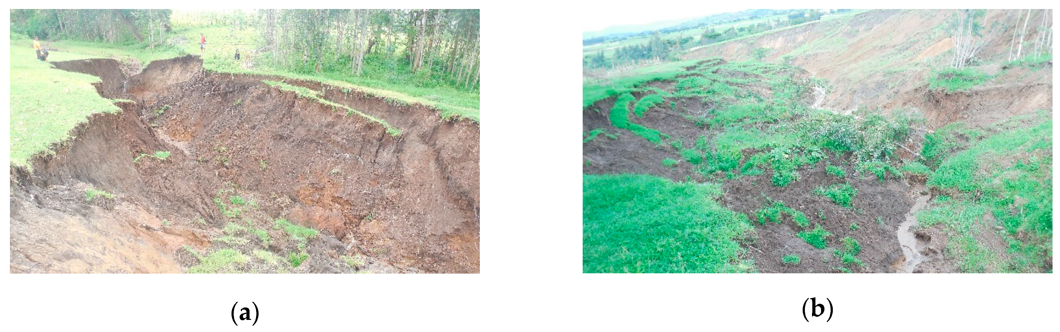
A combination of fluvial and mass wasting erosion mechanisms is responsible for the expansion of gullies at the valley bottoms [32,43,44]. Mass wasting and fluvial erosion progress through several stages to erode the gully banks [16,45]. (Stage 1) erosion of the bank toe is caused by the applied hydraulic shear stress or due to collapsibility, which is stress removal from the base and loss of cohesion due to increased pore water pressure. (Stage 2) This leads to steepening or an overhanging gully bank. The steepened or overhanging bank material then collapses (Figure 2a). (Stage 3) Fluvial erosion removes the failed bank material, and the process (Stages 1–3) repeats itself until either more resistant bank material becomes exposed or the runoff is unable to erode and transport the collapsed bank material. Fluvial erosion may facilitate gully erosion in two ways: directly due to detachment of soil particles or gully head-cut retreat [16], and indirectly by triggering gully bank mass wasting through steepening of the gully bank [46].
Soil saturation, overland runoff, seepage erosion, and crack formation are among the important factors that control gully bank mass wasting. Infiltrating precipitation and overland runoff increase soil weight and saturation. The added weight destabilizes the gully bank [46]. Soil saturation reduces soil shear strength. For example, in semi-arid Colorado, gully mass wasting is primarily due to bank saturation, causing an 80% increase in soil weight [47]. The authors [47] further suggested plunge pools facilitated gully mass-wasting near the head-cut by reducing bedrock strength. Seepage erosion occurs due to the development of critical hydraulic gradients [48] that trigger gully mass wasting. Exfiltration of groundwater to the surface [49] could trigger gully bank mass wasting by washing out soil cementing agents and by increasing soil weight [50]. Soil pipe collapse due to preferential flow may lead to pipe clogging, increasing soil pore water pressure that may cause mass wasting processes [31].
Experimental observations of the interaction of gully formation and change in hydrology are per recent theoretical findings that gullies are the most energy-efficient way to transport excess runoff from the watershed after a landscape disturbance [33,51]. For example, with respect to subsurface drainage, this concentration of flow (e.g., preferential flow paths) rather than equally distributed flow through the soil profile has been observed in many subsurface flow studies where water flows preferentially through the soils, such as fingered flow and funnel flow [52,53]. [54] and [55] showed pipes, and disconnected pipe segments concentrated the flow, thereby further enhancing their dimensions and extent. Gully formation is, therefore, a natural consequence of self-organizing drainage flow paths in the landscape [6,56] with a change in water flux being the main driving force.
Tension cracks are also one of the important factors for gully bank instability [57] as gully mass wasting processes are commonly preceded by the occurrence of tension cracks [19]. On a valley bottom in semi-arid Kenya, tension cracks cause gully mass wasting by allowing more water into the cracks, increasing the soil pore water pressure [58]. Presence of cracks can, also, diminish the load-carrying capacity of soil by up to 30%, thereby affecting gully stability [59]. Thus, the evolution of valley bottom gullies (unlike hillside gullies) are directly linked to the concentration of the flow paths and the greater moisture contents, leading to periodically saturated soil. Saturation of the soil would destabilize gully banks [16], and fluvial processes carry away the unconsolidated sediment from the failed banks.
In the next section, the factors controlling gully formation are presented. We first discussed the topographic factors (slope and drainage area) followed by other factors (precipitation, groundwater depth, land-use, soil type, soil depth, lithology, etc.).
3.2. Factors Related to Valley Bottom Gully Formation
3.2.1. Slope Gradient and Drainage Area
Slope gradient and drainage area are important watershed characteristics that affect the hydrology [80] and thus gully formation (Table 2). Valley bottom gullies are found in gently sloping areas (Table 1) and not on steep slopes. A negative relationship exists between drainage area and slope [48,81]. That is, as the drainage area increases (greater flows), the slope reduces (smaller hydraulic gradients). This, in turn, increases the propensity for soil saturation as the groundwater table rises with greater discharge and smaller hydraulic gradients. Besides, smaller slopes in combination with the occurrence of depressions provide more time for surface water to infiltrate into the soil, thereby increasing the soil moisture content [36].
The increasing flux of water associated with increasing drainage area [60] not only erodes the gully boundary materials but also aids in the evacuation of soil deposited after gully head and bank collapses, thereby accelerating gully head [82] and gully volume [83] expansion. Gully size and gully erosion rate due to lateral gully bank migration increases with increasing drainage area. Similarly, studies undertaken for rivers also found that gentler-sloped reaches (<2%) have larger bank height and retreat rates [84]. Therefore, valley bottomlands with a small catchment area are relatively stable and do not have gullies [85].
3.2.2. Topographic Gully Threshold Indices
Because of the strong relationship between hydrology, erosion, and topography, it is no surprise that several studies [86] have reported the importance of topographic controls on incision of gullies or channel incision in general [87,88]. Most relationships predict the location of ephemeral gullies [81,86,89] independent of how runoff is generated [90]. For permanent gullies, topographic threshold relationships have a different form for semi-arid regions where overland surface runoff dominates [82] and those in humid climates in duplex landscapes with a hardpan with interflow and saturation excess overland flow [28]. Existing topographic threshold predictors developed for semi-arid areas are inaccurate or even erroneous for sub-humid and humid regions [91]. Topographic threshold relationships (with drainage area, soil type, and slope as parameters) accurately predict the locations of permanent gullies caused by Hortonian runoff on valley slopes (e.g., in warm sub-humid Swaziland [92]) and valley bottomlands (e.g., in semi-arid Mediterranean Iberian Peninsula [74] and semi-arid western Colorado [76]). In areas with saturation runoff excess, [93] showed, such as in humid Ethiopian highlands, threshold predictors, indicating elevated soil wetness could predict the location of valley bottom gullies. One of these threshold predictors is the topographic wetness index defined as the ratio of the amount of water delivered to a point (i.e., contributing area) and the amount transmitted (i.e., a product of slope, conductivity, and soil depth) [94].
3.2.3. Precipitation
Soil loss, in general, is a function of rainfall duration, magnitude, and intensity. Based on the world rainfall erosivity map, high to low rainfall erosivity vary between 7105 MJ mm ha−1 h−1 year−1 for tropical regions, 3729 MJ mm ha−1 h−1 year−1 for temperate regions, 843 MJ mm ha−1 h−1 year−1 for arid regions, and 494 MJ mm ha−1 h−1 year−1 for cold climatic regions [95]. Tropical countries, like Ethiopia (specifically the highlands) and Brazil, are among countries with the highest rainfall erosivity records and, at the same time, affected by severe valley bottom erosion. In contrast, there is relatively low soil loss (1.1 Mg ha−1 year−1) recorded for semi-arid Ethiopia, which is in line with the low rainfall erosivity reported for this climatic zone. In general, valley bottom formation becomes more severe for increasing erosivity.
According to Table 2, valley bottom gullies occur across all rainfall regimes in both arid regions, with annual rainfall as low as 90 mm [20], and humid regions, with annual rainfall as high as 1600 mm [77]. This indicates it is not the amount of precipitation in itself causing gully formation, but it is the variability in rainfall. For example, [73] found that the impact of increased rainfall due to climate change on valley bottom gully formation was through increased surface runoff volume, and according to [47], indirectly through increased soil pore-water pressure. Likewise, [16], [35], [96], and [97] found that extended wet periods, coupled with increased runoff volumes, increased the probability of gully widening by bank failures.
Although the initiation of gullies is independent of the amount of precipitation, the rate of gully expansion increases with increasing rainfall amounts. For example, the highest valley bottom gully soil loss (530 t ha−1 year−1) and head-cut retreat (36 m year−1) rates were recorded for sub-humid monsoon-tropical Ethiopian highlands (Table 1).
3.2.4. Groundwater/Surface Runoff
In most valley bottom gully erosion studies (Table 1), the groundwater table was not monitored; hence, the subsurface flow could not be evaluated. For the few studies in which groundwater measurements were conducted, all mentioned elevated groundwater table as an important factor for the genesis of gullies at the valley bottom of a watershed, e.g., in Brazil [77], Ethiopia [30,32,33], and western Iowa [19]. A study also found that the elevated groundwater level above the gully bottom during the rainy period decreased the strength and the erosion resistance of the soil along the gully banks and enhanced mass-wasting [33].
3.2.5. Land-Use
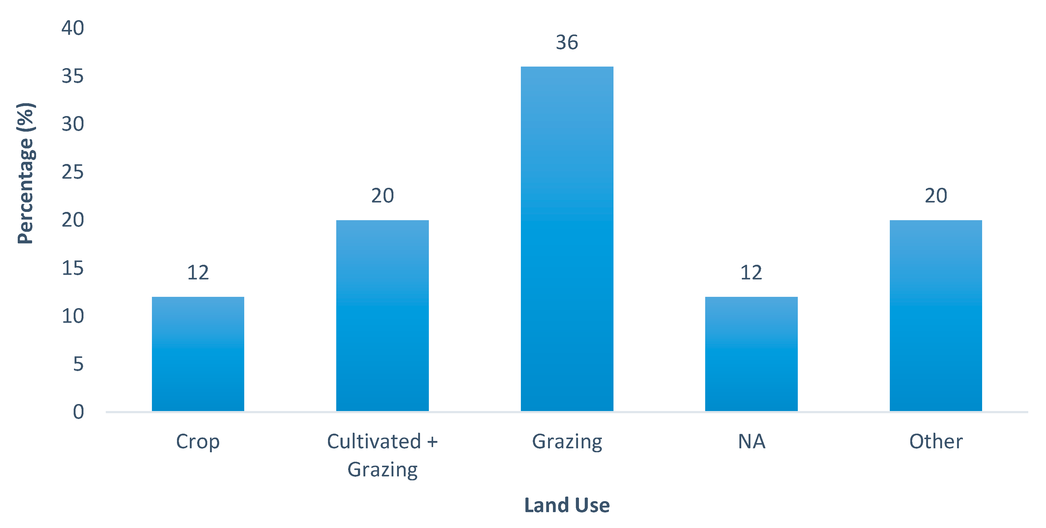
Based on the data presented in Table 1, Figure 3 shows that 36% of the active gullies occurred in grazing land followed by combined crop and grazing land (20%) and other land-use (20%). Only 12% of the active gullies occurred in cropland. Likewise, in Italy [98,99], more gullies have been observed in grazing lands than croplands [18,65]. Valley bottom gully incision seldom commences in forest lands. Although these results seem to strongly point to a relationship between land-use and active gully development, the underlying reason is again the hydrology of the watershed as the grass is grown on soils that are too wet for growing crops [100]. Forest can be found in those parts of the landscape that are usually too dry for good crop yield due to the terrain steepness and/or restricted soil depth.
3.2.6. Land-Use Change
Changes in land-use were mentioned most frequently as the cause of initiating and widening of gully incisions in valley bottom areas (Table 2). The examples of land-use changes related to gully formation in Ethiopia are eucalyptus plantation, cultivation of previously untilled land, conversion of cropland to pasture, and road construction [25,62]. The decline in hillslope vegetation coupled with other factors increases the runoff concentration at the valley bottom, resulting in gully erosion [25]. Deforestation leads to persistently increased wetness in valley bottomlands and followed by gully formation [30]. [60] reported that gully formation was associated with a change in land-use type from forest land to grazing and croplands. Another study reported that, in South Africa, a change from grassland to shrubland increased the presence of bare soil, which caused a four-fold increment in the runoff amount with a corresponding six-fold rise in the erosion rate at the foot slopes [67]. Besides, [68] reported that valley bottom gullies in a semi-arid region were caused by runoff from a degraded area, which was one order of magnitude greater than that from the vegetated areas in the region. [77] reported that, in Brazil, land-use changes from forest to pasture increased runoff resulting in groundwater table rise, increase in saturated area and subsurface flow, which led to gully growth at the valley bottomlands. In Nigeria, [66] reported that the cause of valley bottom gully development was associated with hydrological changes due to dam and reservoir construction. Further, a relatively large percentage of the reviewed articles (12%) did not state the land-use type of the gullied catchment (Figure 3). This signifies that land-use was not directly related to valley bottom gullies. This is per our hypotheses that change in land-use is responsible for gully formation and not the land-use itself. In summary, in all cases, the unifying principle is that the land-use change caused increased runoff and/or wetness in valley bottoms and enhanced gully development.
3.2.7. Soil
The reviewed publications (Table 1) showed that there is not a specific soil type in which gully formation does not occur. What is different among the studies is the size (both width and depth) and the form of the gullies for the various soil types. This is in agreement with our hypothesis that valley bottom gully formation is caused by the changes in hydrology, and thus resilience of rock deposits to erosion and the nature of geomorphic processes determine the shape of the cross-section [17]. The major soil characteristics that govern mass-wasting after the hydrology has changed are the soil strength, erosion resistance, the type of soils (e.g., loess and vertisols), and the type of soil deposits (alluvium and colluvium).
Of all soil types, loess and vertisols are the dominant types reported in the literature for areas with valley bottom gullies. Both loess soil [19,42] and vertisol [25,60,61,65] create a favorable condition for valley bottom gully initiation and accelerated growth resulting in large gullies after the hydrology is changed. Vertisols are characterized by deep and wide cracks [65] that allow preferential water flow into the cracks, which increases soil pore-water pressure and promotes gully formation [61]. Also, the high swelling and shrinkage nature of vertisols favors the formation of gullies at the valley bottom [25], complicating the implementation of gully reclamation measures. Loess soils have a large fraction of silt (up to 60%) and low clay and organic matter content [101], and therefore little cohesion. Accordingly, gully banks in silty textured soils are less stable and have lower friction angles (<30°) [45].
Another principle that most studies have in common, although not stated directly but singled out by [28] and noted by [102,103,104], is that gully formation occurs from duplex soils in the upland where a shallow permeable soil overlays a dense subsoil. As noted by [105] and [106], the duplex soils formation, that is enhanced by continuous tillage after clear-cutting, decreases baseflow, and increases direct runoff. Tillage results in the loss of organic matter. When the organic matter decreases below 3%, the aggregates break up [74] and form a fine disperse soil, depending on the parent material, soil structure, high clay disparity, low pH (4.7–6.4), low cation exchange capacity [91,98], that is easily picked up by raindrop splash and remains in suspension. This then leads to land degradation in the uplands with a slowly permeable layer formed by the fine soil particles carried by the infiltrating rainwater [71,105].
Deep percolation in the degraded duplex soils on the hillslopes has decreased, and shallow interflow has increased [107], which brings about an expansion of the saturated areas [30,108] and consequently leads to channel and gully incisions and expansions [46]. Due to the increased erosion vulnerability with increasing saturation [109,110], large volumes of sediment are transported out of the watershed. The bottomlands in the Debre Mawi watershed, sub-humid Ethiopia, are a good example of gully erosion caused by hillslope land-use changes [32].
3.2.8. Alluvium and Colluvium
Alluvium and colluvium are the dominant formations where valley bottom gullies are reported (Table 1). The primary soil characteristics associated with alluvium and colluvium deposits in the valley bottoms are greater depth [30,60], e.g., up to 8 m [67]; and low roughness and stoniness [18]. However, only a few studies quantitatively stated soil depth. The low roughness and stoniness may ascribe to the valley bottom areas having well-sorted fine-textured alluvial and colluvium formations [19,73,74,77]. In a grazing land valley bottom dominated with thick phaeozems soil type, [18] reported gully volume was directly correlated with soil thickness and inversely correlated with surface roughness and stoniness. Because alluvium and colluvium deposited materials near the ground surface are generally unconsolidated and loose, they, coupled with other factors, may create a conducive situation for their erosion by water. Alluvium and colluvium deposits can also exhibit valley bottom lithological discontinuities across the soil profile. Such lithological discontinuities at the valley bottom, in turn, cause pipe occurrence, leading to gully formation and expansion [111].
3.3. Soil Loss
Table 2 presents published soil loss from valley bottom gully erosion. The average soil loss for arid and semi-arid region ranged between 0.063 and 33.5 t ha−1 year−1, whereas, for sub-humid regions, the values were in the range between 31 and 530 t ha−1 year−1 (Table 2). In humid regions, the soil loss value is about one order of magnitude higher than in arid regions, signifying the severity of VBG erosion in those regions.
It is, however, difficult to compare the soil loss values between studies because the reported studies used different experimental design, study period, and units. Some studies reported combined soil loss from valley bottom gullies and hillslope gullies, which is noted in Table 2.
3.4. Conservation Measures
Gully development depends on geomorphological [112,113] and hydrological [6,7] parameters (Table 1). Since these hydrological and geomorphological parameters vary between hillslope and valley bottomlands [36], the type of rehabilitation measures that are likely to be effective will also vary.
Once valley bottom gullies have developed, their reclamation is challenging. Gully reclamation, through vegetation [114] and construction of brushwood check dams and flood regulators, is effective at hillslope positions [25] but fails at the valley bottom [115], where they often exacerbate the rate of gully expansion [12,116]. Valley bottom gully erosion mostly occurs in heavily textured soils [117], where structural reclamation measures fail as a result of soil swelling and shrinkage. Rehabilitation of valley bottom gullies using vegetation is difficult as their growth is dominated by mass-wasting processes that require structural stabilization measures [7]. The high economic cost of valley bottom gully rehabilitation is another challenge [24]. There are, however, rare cases where the processes that control valley bottom gully erosion are similar to that of hillslope gullies, and hillslope reclamation practices may work for valley bottom gullies (e.g., semi-arid South Africa [67]).
A small number of studies (Table 1) have been conducted towards the assessment of valley bottom gully reclamation measures. Some successful valley bottom gully reclamation activities in semi-arid regions were reported, whereas, in sub-humid regions, rehabilitation measures have been mostly unsuccessful.
Valley bottom gullies reclamation measures seem effective in arid and semi-arid areas where Hortonian overland flow is the dominant runoff process. For example, in South Africa, the implementation of reclamation measures in the semi-arid climate showed a reduction in gully expansion [67]. On China’s Loess Plateau with less than 600 mm annual rainfall, a 60% increase in vegetation cover on the hillslope significantly decreased gullies at valley bottom areas [118]. In semi-arid Ethiopia, an experiment conducted for about two years with vegetative measures at the shoulder, wall, and floor of gullies also proved to be effective in halting gully erosion [119].
On the other hand, in humid areas, where subsurface or saturation-excess-induced erosion is the cause of gullies, stabilizing gullies with existing hillslope gully reclamation measures is challenging. In tropical Brazil, the construction, of terraces to conserve valley bottom gullies, was unsuccessful and created new small gullies at the foot slopes [77]. This may be due to terraces only decreasing the impact of surface runoff, but increasing water recharge to the soil, which in turn increases soil pore water pressure that can lead to pipe flow and formation of new gullies [19,77]. In sub-humid Ethiopia, rehabilitation of valley bottom gullies was reported to be unsuccessful but proved to be effective at hillslope locations [12,105].
A research effort to better understand gully erosion mechanisms and their controlling factors over a wide range of environmental conditions is fundamental for the identification and adoption of possible conservation strategies [120,121]. Given the factors introduced earlier, valley bottom gully reclamation measures should consider both overland and subsurface flow driven erosion. For example, for gully erosion caused by subsurface flow processes, reclamation measures should focus on reducing the groundwater table elevation and reshaping of tall gully banks to prevent bank and gully head failures [32], and covering the valley bottom with wetland plants [105]. Conservation activities that reduce the flow energy near the head-cut have a positive effect on reducing gully erosion rates [16]. Reclamation measures, such as facilitating drainage and vegetative measures, play a role in the stabilization of gullies by increasing the shear strength of the soil [96,122]. Integration of vegetation and structural engineering measures have also proven to provide a better gully erosion control than using a single type of gully conservation measure [123]. Vegetation increases the strength of the gully boundary materials and reduces the susceptibility of a gully to external forces, such as surface runoff. Trees can, for instance, provide an additional 15 KPa of cohesive strength for the upper 1.5 m of a stream bank [124]. The effectiveness of vegetation measures has been strongly associated with the distribution rather than the total vegetation [125]. [92] proposed dense vegetative reclamation measures when Hortonian overland flow dominates, whereas, for gullies caused by seepage and high soil pore-water pressure conditions, deep-rooted vegetation that enhance evapotranspiration was proposed.
Reclamation activities in upland areas that drain into a gully can be equally important as reclamation of the gully channel itself. Even though hillslope conservation measures are effective in decreasing the amount of sediment and runoff volume, in some cases, they lead to the growth or incision of valley bottom gullies [12]. Adverse effects of hillslope conservation measures are evidenced by infiltration, increasing soil pore-water pressures, or by delivery of sediment-starved water to the valley bottom [126]. In summary, reclamation measures should not only be restricted to the valley bottomlands, and it will be most effective when both hillslope and valley bottom rehabilitation activities are integrated within the valley bottom drainage area.
4. Conclusions
Due to various on- and off-site factors, valley bottomlands are landscape units that are more vulnerable to gully erosion than hillslope areas. Valley bottomlands are also geomorphologically and hydrologically different from hillslope areas. These differences promote contrasting erosion processes and, therefore, require different rehabilitation measures for valley bottomlands than hillslopes. Nevertheless, research to date has not revealed the need for a different treatment of gullies located at valley bottoms. In this review, we distinguished the parameters, affecting the vulnerability of valley bottomland to gully erosion, and categorized them as susceptibility and driving factors. Presence of thick alluvium and colluvium deposits, loess soils, vertisols, and intensively grazed and cultivated lands are among the factors that make valley bottomland susceptible to gullies. Due to intensive agricultural activities, most valley bottom gullies are reported on grazing and cultivated land-use types. Topographical factors, such as drainage area and slope gradient, and precipitation are among the factors that drive the development of gullies at the valley bottom. The dominant runoff process controlling valley bottom gully erosion in arid and humid regions differs, i.e., Hortonian overland runoff and saturation excess runoff, respectively. The integral impact of these hydrological and geomorphological factors negatively affects soil stability by lowering soil shear strength and erosion resistance, leading to combined fluvial and mass-wasting gully erosion processes.
Rehabilitation measures of valley bottom gullies are effective for Hortonian overland runoff driven erosion (arid regions), whereas, for saturation excess driven erosion (humid regions), implementation of rehabilitation measures are mostly unsuccessful. Similarly, estimation of valley bottom gullies occurrence using existing topographical threshold predictors have worked well for Hortonian overland-flow controlled gullies, whereas, for valley bottom gullies controlled by subsurface flow processes, the use of such a threshold predictor might be flawed.
In summary, valley bottomlands are more susceptible to gully erosion than hillslopes, and controlling factors could be different between the two landscape positions. Therefore, valley bottom gullies should be approached differently than the usually grouped characterization with hillslope gullies. Existing gully erosion topographical threshold predictors, for humid and sub-humid regions, should be re-evaluated to better define the drainage areas into valley bottom gullies so that effective prevention and implementation of rehabilitation measures can be successful. However, successful implementation of rehabilitation measures, especially for humid regions, requires that understanding the erosion process should come first, and an integrated landscape approach that, among others, accounts for the combined subsurface and surface drainage into the valley bottomlands must be followed.
Author Contributions
Conceptualization, S.A., S.K., M.v.d.P., E.L., T.S., and S.T.; methodology, S.A., S.K., and M.v.d.P.; investigation, S.A.; visualization S.A., S.K., M.v.d.P., E.L., and T.S.; Writing—original draft, S.A., Writing—review and editing, S.A., S.K., M.v.d.P., E.L., T.S., and S.T.
Funding
This research was funded by NFP (Netherlands Fellowship Program), grant number 5160957248 and Schlumberger Foundation, Faculty for the Future Program.
Acknowledgments
The author would like to thank Bahir Dar University for providing the opportunity to undertake her Ph.D.
Conflicts of Interest
The authors declare no conflict of interest.
References
- Billi, P.; Dramis, F. Geomorphological investigation on gully erosion in the Rift Valley and the northern highlands of Ethiopia. Catena 2003, 50, 353–368. [Google Scholar] [CrossRef]
- Ionita, I.; Fullen, M.A.; Zgłobicki, W.; Poesen, J. Gully erosion as a natural and human-induced hazard. Nat. Hazards 2015, 79, 1–5. [Google Scholar] [CrossRef] [Green Version]
- Ghimire, S.K.; Higaki, D.; Bhattarai, T.P. Gully erosion in the Siwalik Hills, Nepal: Estimation of sediment production from active ephemeral gullies. Earth Surf. Process. Landforms 2006, 31, 155–165. [Google Scholar] [CrossRef]
- Muñoz-Robles, C.; Reid, N.; Frazier, P.; Tighe, M.; Briggs, S.V.; Wilson, B. Factors related to gully erosion in woody encroachment in south-eastern Australia. Catena 2010, 83, 148–157. [Google Scholar] [CrossRef]
- Kertész, Á.; Gergely, J. Gully erosion in Hungary, review and case study. Procedia Soc. Behav. Sci. 2011, 19, 693–701. [Google Scholar] [CrossRef] [Green Version]
- Poesen, J.; Nachtergaele, J.; Verstraeten, G.; Valentin, C. Gully erosion and environmental change: Importance and research needs. Catena 2003, 50, 91–133. [Google Scholar] [CrossRef]
- Valentin, C.; Poesen, J.; Li, Y. Gully erosion: Impacts, factors and control. Catena 2005, 63, 132–153. [Google Scholar] [CrossRef]
- Castillo, C.; Gómez, J.; Rodríguez, C.C. A century of gully erosion research: Urgency, complexity and study approaches. Earth-Sci. Rev. 2016, 160, 300–319. [Google Scholar] [CrossRef]
- Vanmaercke, M.; Poesen, J.; Van Mele, B.; Demuzere, M.; Bruynseels, A.; Golosov, V.; Bezerra, J.F.R.; Bolysov, S.; Dvinskih, A.; Frankl, A.; et al. How fast do gully headcuts retreat? Earth-Sci. Rev. 2016, 154, 336–355. [Google Scholar] [CrossRef]
- McCloskey, G.; Wasson, R.; Boggs, G.; Douglas, M. Timing and causes of gully erosion in the riparian zone of the semi-arid tropical Victoria River, Australia: Management implications. Geomorphology 2016, 266, 96–104. [Google Scholar] [CrossRef]
- Little, W.C.; Piest, R.F.; Robinson, A.R. Sea Research Program for Channel Stability and Gully Control. Trans. ASAE 1980, 23, 362–365. [Google Scholar] [CrossRef]
- Dagnew, D.C.; Guzman, C.D.; Zegeye, A.D.; Tibebu, T.Y.; Getaneh, M.; Abate, S.; Zemale, F.A.; Ayana, E.K.; Tilahun, S.A.; Steenhuis, T.S. Impact of conservationractices on runoff and soil loss in the sub-humid Ethiopian Highlands: The Debre Mawi watershed. J. Hydrol. Hydromech. 2015, 63, 210–219. [Google Scholar] [CrossRef]
- Zegeye, A.D.; Langendoen, E.J.; Guzman, C.D.; Dagnew, D.C.; Amare, S.D.; Tilahun, S.A.; Steenhuis, T.S. Gullies, a critical link in landscape soil loss: A case study in the subhumid highlands of Ethiopia. Land Degrad. Dev. 2018, 29, 1222–1232. [Google Scholar] [CrossRef]
- Soil Science Glossary Terms Committee. Glossary of Soil Science Terms; Soil Science Society of America: Madison, WI, USA, 2008. [Google Scholar]
- Poesen, J. Gully typology and gully control measures in the European loess belt. In Farm Land Erosion in Temperate Plains Environment and Hills. Proc. Symposium, Saint-Cloud, Paris, 1992; Elsevier Science Publishers: Amsterdam, The Netherlands, 1993; pp. 221–239. [Google Scholar]
- Bradford, J.M.; Piest, R.F. Erosional development of valley-bottom gullies in the upper midwestern United States. In Threshold in Geomorphology; Coates, D.R., Vitak, J.D., Eds.; Allen and Unwin: London, UK, 1980; pp. 75–101. [Google Scholar]
- Rădoane, M.; Rădoane, N. Gully Erosion. In Landform Dynamics and Evolution in Romania; Springer: Berlin/Heidelberg, Germany, 2017; pp. 371–396. [Google Scholar]
- Descroix, L.; Barrios, J.G.; Viramontes, D.; Poulenard, J.; Anaya, E.; Esteves, M.; Estrada, J. Gully and sheet erosion on subtropical mountain slopes: Their respective roles and the scale effect. Catena 2008, 72, 325–339. [Google Scholar] [CrossRef]
- Thomas, J.T.; Iverson, N.R.; Burkart, M.R. Bank-collapse processes in a valley-bottom gully, western Iowa. Earth Surf. Process. Landforms 2009, 34, 109–122. [Google Scholar] [CrossRef]
- Stavi, I.; Perevolotsky, A.; Avni, Y. Effects of gully formation and headcut retreat on primary production in an arid rangeland: Natural desertification in action. J. Arid. Environ. 2010, 74, 221–228. [Google Scholar] [CrossRef]
- Nogueras, P.; Burjachs, F.; Gallart, F.; Puigdefàbregas, J. Recent gully erosion in the El Cautivo badlands (Tabernas, SE Spain). Catena 2000, 40, 203–215. [Google Scholar] [CrossRef]
- Addisie, M.B.; Langendoen, E.J.; Aynalem, D.W.; Ayele, G.K.; Tilahun, S.A.; Schmitter, P.; Mekuria, W.; Moges, M.M.; Steenhuis, T.S. Assessment of Practices for Controlling Shallow Valley-Bottom Gullies in the Sub-Humid Ethiopian Highlands. Water 2018, 10, 389. [Google Scholar] [CrossRef]
- Poesen, J.; Valentin, C. Gully erosion and global change—Preface. Catena 2003, 50, 87–89. [Google Scholar] [CrossRef]
- Moges, A.; Holden, N.M. Estimating the rate and consequences of gully development, a case study of umbulo catchment in Southern Ethiopia. Land Degrad. Dev. 2008, 19, 574–586. [Google Scholar] [CrossRef]
- Nyssen, J.; Poesen, J.; Moeyersons, J.; Haile, M.; Deckers, J.; Dewit, J.; Naudts, J.; Teka, K.; Govers, G.; Veyret-Picot, M.; et al. Assessment of gully erosion rates through interviews and measurements: A case study from northern Ethiopia. Earth Surf. Process. Landforms 2006, 31, 167–185. [Google Scholar] [CrossRef]
- Elsen, E.V.D.; Xie, Y.; Liu, B.; Stolte, J.; Wu, Y.; Trouwborst, K.; Ritsema, C.J. Intensive water content and discharge measurement system in a hillslope gully in China. Catena 2003, 54, 93–115. [Google Scholar] [CrossRef]
- Moges, M.A.; Schmitter, P.; Tilahun, S.A.; Langan, S.; Dagnew, D.C.; Akale, A.T.; Steenhuis, T.S. Suitability of watershed models to predict distributed hydrologic response in the awramba watershed in lake Tana basin. Land Degrad. Dev. 2017, 28, 1386–1397. [Google Scholar] [CrossRef]
- Wilson, G.V.; Wells, R.; Kuhnle, R.; Fox, G.; Nieber, J. Sediment detachment and transport processes associated with internal erosion of soil pipes. Earth Surf. Process. Landforms 2018, 43, 45–63. [Google Scholar] [CrossRef]
- Fox, G.A.; Chu-Agor, M.L.; Wilson, G.V. Seepage erosion: A significant mechanism of stream bank failure, Restoring Our Natural Habitat. In Proceedings of the 2007 World Environmental and Water Resources Congress, Tampa, FL, USA, 15–19 May 2007. [Google Scholar]
- Tebebu, T.Y.; Abiy, A.Z.; Dahlke, H.E.; Easton, Z.M.; Zegeye, A.D.; Tilahun, S.A.; Collick, A.S.; Kidnau, S.; Moges, S.; Dadgari, F.; et al. Surface and subsurface flow effect on permanent gully formation and upland erosion near Lake Tana in the Northern Highlands of Ethiopia. Hydrol. Earth Syst. Sci. Discuss. 2010, 7, 5235–5265. [Google Scholar] [CrossRef]
- Fox, G.A.; Wilson, G.V. The Role of Subsurface Flow in Hillslope and Stream Bank Erosion: A Review. Soil Sci. Soc. Am. J. 2010, 74, 717. [Google Scholar] [CrossRef]
- Zegeye, A.D.; Langendoen, E.J.; Stoof, C.R.; Tilahun, S.A.; Dagnew, D.C.; Zimale, F.A.; Guzman, C.D.; Yitaferu, B.; Steenhuis, T.S. Morphological dynamics of gully systems in the subhumid Ethiopian Highlands: The Debre Mawi watershed. Soil 2016, 2, 443–458. [Google Scholar] [CrossRef]
- Addisie, M.B.; Ayele, G.K.; Gessess, A.A.; Tilahun, S.A.; Zegeye, A.D.; Moges, M.M.; Schmitter, P.; Langendoen, E.J.; Steenhuis, T.S. Gully Head Retreat in the Sub-Humid Ethiopian Highlands: The Ene-Chilala Catchment. Land Degrad. Dev. 2017, 28, 1579–1588. [Google Scholar] [CrossRef]
- Bernatek-Jakiel, A.; Poesen, J. Subsurface erosion by soil piping: Significance and research needs. Earth-Sci. Rev. 2018, 185, 1107–1128. [Google Scholar] [CrossRef]
- Okagbue, C.; Uma, K. Performance of gully erosion control measures in southeastern Nigeria. In Forest Hydrology and Watershed Management; Swanson, R.H., Bernier, P.Y., Woodard, P.D., Eds.; Iowa State University Press: Ames, IA, USA, 1987. [Google Scholar]
- Dowling, T.I.; Gallant, J.C. A multiresolution index of valley bottom flatness for mapping depositional areas. Water Resour. Res. 2003, 39, 14. [Google Scholar]
- Fagbami, A.; Ajayi, F.O. Valley bottom soils of the sub-humid tropical Southwestern Nigeria on basement complex: Characteristics and classification. Soil Sci. Plant Nutr. 1990, 36, 179–194. [Google Scholar] [CrossRef]
- Lidon, B.; Legoupil, J.C.; Blanchet, F.; Simpara, M.; Sanogo, I. Rapid pre-development diagnosis (DIARPA). A development aid for valley bottoms. Agric. Dev. 1998, 123, 61–80. [Google Scholar]
- Keïta, A.; Hayde, L.G.; Yacouba, H.; Schultz, B. Valley Bottom Clay Distribution and Adapted Drainage Techniques. Lowl. Technol. Int. 2014, 16, 135–142. [Google Scholar] [CrossRef]
- Rebelo, A.J.; Le Maitre, D.C.; Esler, K.J.; Cowling, R.M. Hydrological responses of a valley-bottom wetland to land-use/land-cover change in a South African catchment: Making a case for wetland restoration. Restor. Ecol. 2015, 23, 829–841. [Google Scholar] [CrossRef]
- Carnicelli, S.; Benvenuti, M.; Ferrari, G.; Sagri, M. Dynamics and driving factors of late Holocene gullying in the Main Ethiopian Rift (MER). Geomorphology 2009, 103, 541–554. [Google Scholar] [CrossRef]
- Thomas, J.T.; Iverson, N.R.; Burkart, M.R.; Kramer, L.A. Long-term growth of a valley-bottom gully, western Iowa. Earth Surf. Process. Landforms 2004, 29, 995–1009. [Google Scholar] [CrossRef] [Green Version]
- Thorne, C. River width adjustment. I: Processes and mechanisms. J. Hydraul. Eng. 1998, 124, 881–902. [Google Scholar]
- Istanbulluoglu, E.; Bras, R.L.; Flores-Cervantes, H.; Tucker, G.E. Implications of bank failures and fluvial erosion for gully development: Field observations and modeling. J. Geophys. Res. Space Phys. 2005, 110, 110. [Google Scholar] [CrossRef]
- Bradford, J.M.; Farrell, D.A.; Larson, W.E. Mathematical Evaluation of Factors Affecting Gully Stability1. Soil Sci. Soc. Am. J. 1973, 37, 103–107. [Google Scholar] [CrossRef]
- Kleidon, A.; Zehe, E.; Ehret, U.; Scherer, U. Thermodynamics, maximum power, and the dynamics of preferential river flow structures at the continental scale. Hydrol. Earth Syst. Sci. 2013, 17, 225–251. [Google Scholar] [CrossRef] [Green Version]
- Rengers, F.K.; Tucker, G.E. The evolution of gully headcut morphology: A case study using terrestrial laser scanning and hydrological monitoring. Earth Surf. Process. Landforms 2015, 40, 1304–1317. [Google Scholar] [CrossRef]
- Dietrich, W.E.; Dunne, T. The channel head. In Channel Network Hydrology; John Wiley & Sons: Hoboken, NJ, USA, 1993; pp. 175–219. [Google Scholar]
- Spence, C.D.; Sauchyn, D.J. Groundwater influence on valley-head geomorphology, upper Battle Creek basin, Alberta and Saskatchewan. Bull. Geol. Surv. Can. 1999, 534, 249–255. [Google Scholar]
- Midgley, T.L.; Fox, G.A.; Wilson, G.V.; Heeren, D.M.; Simon, A.; Langendoen, E.J. Streambank erosion and instability induced by groundwater seepage. In Proceedings of the American Society of Agricultural and Biological Engineers Annual International Meeting 2011, ASABE 2011, Louisville, KY, USA, 7–10 August 2011; pp. 3009–3029. [Google Scholar]
- Zehe, E.; Elsenbeer, H.; Lindenmaier, F.; Schulz, K.; Bloschl, G. Patterns of predictability in hydrological threshold systems. Water Resour. Res. 2007, 43, 43. [Google Scholar] [CrossRef]
- Selker, J.S.; Steenhuis, T.S.; Parlange, J.-Y. Wetting Front Instability in Homogeneous Sandy Soils under Continuous Infiltration. Soil Sci. Soc. Am. J. 1992, 56, 1346. [Google Scholar] [CrossRef]
- Kung, K.-J.S. Laboratory Observation of Funnel Flow Mechanism and its Influence on Solute Transport. J. Environ. Qual. 1993, 22, 91. [Google Scholar] [CrossRef]
- Nieber, J.L.; Warner, G.S. Soil pipe contribution to steady subsurface stormflow. Hydrol. Process. 1991, 5, 329–344. [Google Scholar] [CrossRef]
- Nieber, J.L.; Sidle, R.C. How do disconnected macropores in sloping soils facilitate preferential flow? Hydrol. Process. 2010, 24, 1582–1594. [Google Scholar] [CrossRef]
- Rodriguez-Iturbe, I.; Rinaldo, A. Fractal river basins: Chance and Self-Organization; Cambridge University Press: Cambridge, UK, 2001. [Google Scholar]
- Wijdenes, D.J.O.; Poesen, J.; Vandekerckhove, L.; Nachtergaele, J.; De Baerdemaeker, J. Gully-head morphology and implications for gully development on abandoned fields in a semi-arid environment, Sierra de Gata, southeast Spain. Earth Surf. Process. Landforms 1999, 24, 585–603. [Google Scholar] [CrossRef]
- Wijdenes, D.J.O.; Bryan, R. Gully-head erosion processes on a semi-arid valley floor in Kenya: A case study into temporal variation and sediment budgeting. Earth Surf. Process. Landforms 2001, 26, 911–933. [Google Scholar] [CrossRef]
- Langendoen, E.J.; Simon, A. Closure to “Modeling the evolution of incised streams. II: Streambank erosion” by Eddy J. Langendoen and Andrew Simon. J. Hydraul. Eng. 2009, 135, 1107–1108. [Google Scholar] [CrossRef]
- Mukai, S. Gully Erosion Rates and Analysis of Determining Factors: A Case Study from the Semi-arid Main Ethiopian Rift Valley. Land Degrad. Dev. 2016, 28, 602–615. [Google Scholar] [CrossRef]
- Nyssen, J.; Veyret-Picot, M.; Poesen, J.; Moeyersons, J.; Haile, M.; Deckers, J.; Govers, G. The effectiveness of loose rock check dams for gully control in Tigray, northern Ethiopia. Soil Use Manag. 2004, 20, 55–64. [Google Scholar] [CrossRef]
- Nyssen, J.; Poesen, J.; Moeyersons, J.; Luyten, E.; Veyret-Picot, M.; Deckers, J.; Haile, M.; Govers, G.; Veyret-Picot, M. Impact of road building on gully erosion risk: A case study from the Northern Ethiopian Highlands. Earth Surf. Process. Landforms 2002, 27, 1267–1283. [Google Scholar] [CrossRef]
- Nyssen, J.; Moeyersons, J.; Deckers, J.; Haile, M.; Poesen, J. Vertic movements and the development of stone covers and gullies, Tigray Highlands, Ethiopia. Z. Geomorphol. 2000, 44, 145–164. [Google Scholar]
- Hagos, G.; Gessesse, D.; Awdenegest, M. Rate of gully expansion on major land uses, the case of Huluka watershed, Central Rift Valley, Ethiopia. J. Biol. Agric. Healthc. 2014, 4, 63–69. [Google Scholar]
- Tilahun, S.A.; Guzman, C.D.; Zegeye, A.D.; Ayana, E.K.; Collick, A.S.; Yitaferu, B.; Steenhuis, T.S. Spatial and Temporal Patterns of Soil Erosion in the Semi-humid Ethiopian Highlands: A Case Study of Debre Mawi Watershed. In Nile River Basin; Springer Science and Business Media LLC: Berlin/Heidelberg, Germany, 2014; Volume 9783319027203, pp. 149–163. [Google Scholar]
- Olofin, E. Some effects of the Tiga Dam on valleyside erosion in downstream reaches of the River Kano. Appl. Geogr. 1984, 4, 321–332. [Google Scholar] [CrossRef]
- Boardman, J.; Parsons, A.; Holland, R.; Holmes, P.; Washington, R.; Parsons, A. Development of badlands and gullies in the Sneeuberg, Great Karoo, South Africa. Catena 2003, 50, 165–184. [Google Scholar] [CrossRef]
- Boardman, J. How old are the gullies (dongas) of the Sneeuberg uplands, Eastern Karoo, South Africa? Catena 2014, 113, 79–85. [Google Scholar] [CrossRef]
- Rowntree, K. The evil of sluits: A re-assessment of soil erosion in the Karoo of South Africa as portrayed in century-old sources. J. Environ. Manag. 2013, 130, 98–105. [Google Scholar] [CrossRef] [Green Version]
- Prosser, I.P.; Slade, C.J. Gully formation and the role of valley-floor vegetation, southeastern Australia. Geology 1994, 22, 1127. [Google Scholar] [CrossRef]
- Strunk, H. Soil degradation and overland flow as causes of gully erosion on mountain pastures and in forests. Catena 2003, 50, 185–198. [Google Scholar] [CrossRef]
- Ionita, I.; Niacsu, L. Land degradation and soil conservation within the Pereshivul Mic catchment—Tutova Rolling Hills. Lucrari Stiintifice, Universitatea de Stiinte Agricole Si Medicina Veterinara “Ion Ionescu de la Brad” Iasi. Seria Agron. 2010, 53, 105–109. [Google Scholar]
- Gómez-Gutiérrez, Á.; Schnabel, S.; De Sanjosé, J.J.; Contador, F.L. Exploring the relationships between gully erosion and hydrology in rangelands of SW Spain. Z. Geomorphol. Suppl. Issues 2012, 56, 27–44. [Google Scholar] [CrossRef]
- Gutiérrez Álvaro, G.; Schnabel, S.; Contador, F.L. Gully erosion, land use and topographical thresholds during the last 60 years in a small rangeland catchment in SW Spain. Land Degrad. Dev. 2009, 20, 535–550. [Google Scholar] [CrossRef]
- Mosley, M.P. Evolution of A Discontinuous Gully System. Ann. Assoc. Am. Geogr. 1972, 62, 655–663. [Google Scholar] [CrossRef]
- Patton, P.C.; Schumm, S.A. Gully erosion, Northwestern Colorado: A threshold phenomenon. Geology 1975, 3, 88–90. [Google Scholar] [CrossRef]
- Marinho, G.V.; de Castro, S.S.; de Campos, A.B. Hydrology and gully processes in the upper Araguaia River basin, Central Brazil. Z. Geomorphol. Suppl. 2006, 145, 119–145. [Google Scholar]
- Gellis, A.C.; Pavich, M.J.; Bierman, P.R.; Clapp, E.M.; Ellevein, A.; Aby, S. Modern sediment yield compared to geologic rates of sediment production in a semi-arid basin, New Mexico: Assessing the human impact. Earth Surf. Process. Landforms 2004, 29, 1359–1372. [Google Scholar] [CrossRef]
- Jahn, R.; Blume, H.; Asio, V.; Spaargaren, O.; Schad, P. Guidelines for Soil Description; FAO: Rome, Italy, 2006. [Google Scholar]
- Ali, G.; Birkel, C.; Tetzlaff, D.; Soulsby, C.; McDonnell, J.J.; Tarolli, P. A comparison of wetness indices for the prediction of observed connected saturated areas under contrasting conditions. Earth Surf. Process. Landforms 2014, 39, 399–413. [Google Scholar] [CrossRef]
- Desmet, P.; Poesen, J.; Govers, G.; Vandaele, K. Importance of slope gradient and contributing area for optimal prediction of the initiation and trajectory of ephemeral gullies. Catena 1999, 37, 377–392. [Google Scholar] [CrossRef]
- Torri, D.; Poesen, J. A review of topographic threshold conditions for gully head development in different environments. Earth-Sci. Rev. 2014, 130, 73–85. [Google Scholar] [CrossRef]
- Frankl, A.; Poesen, J.; Scholiers, N.; Jacob, M.; Haile, M.; Deckers, J.; Nyssen, J. Factors controlling the morphology and volume (V)-length (L) relations of permanent gullies in the northern Ethiopian Highlands. Earth Surf. Process. Landforms 2013, 38, 1672–1684. [Google Scholar] [CrossRef]
- MacFall, J.; Robinette, P.; Welch, D. Factors Influencing Bank Geomorphology and Erosion of the Haw River, a High Order River in North Carolina, since European Settlement. PLoS ONE 2014, 9, e110170. [Google Scholar] [CrossRef] [PubMed]
- Begin, Z.B.; Schumm, S.A. Instability of Alluvial Valley Floors: A Method for its Assessment. Trans. ASAE 1979, 22, 347–350. [Google Scholar] [CrossRef]
- Moore, I.D.; Burch, G.J.; MacKenzie, D.H. Topographic Effects on the Distribution of Surface Soil Water and the Location of Ephemeral Gullies. Trans. ASAE 1988, 31, 1098–1107. [Google Scholar] [CrossRef]
- Prosser, I.P.; Abernethy, B. Predicting the Topographic Limits to a Gully Network Using a Digital Terrain Model and Process Thresholds. Water Resour. Res. 1996, 32, 2289–2298. [Google Scholar] [CrossRef]
- Horton, R.E. Erosional Development of Streams and Their Drainage Basins; Hydrophysical Approach to Quantitative Morphology. GSA Bull. 1945, 56, 275–370. [Google Scholar] [CrossRef]
- Vandaele, K.; Poesen, J.; Govers, G.; Van Wesemael, B. Geomorphic threshold conditions for ephemeral gully incision. Geomorphology 1996, 16, 161–173. [Google Scholar] [CrossRef]
- Vandaele, K.; Poesen, J.; Marques De Silva, J.R.; Govers, G.; Desmet, P. Assessment of factors controlling ephemeral gully erosion in Southern Portugal and Central Belgium using aerial photographs. Z. Geomorphol. 1997, 41, 273–287. [Google Scholar]
- Vandekerckhove, L.; Poesen, J.; Wijdenes, D.O.; Nachtergaele, J.; Kosmas, C.; Roxo, M.; De Figueiredo, T. Thresholds for gully initiation and sedimentation in Mediterranean Europe. Earth Surf. Process. Landforms 2000, 25, 1201–1220. [Google Scholar] [CrossRef]
- Morgan, R.; Mngomezulu, D. Threshold conditions for initiation of valley-side gullies in the Middle Veld of Swaziland. Catena 2003, 50, 401–414. [Google Scholar] [CrossRef]
- Mhiret, D.A.; Dagnew, D.C.; Assefa, T.T.; Tilahun, S.A.; Zaitchik, B.F.; Steenhuis, T.S. Erosion hotspot identification in the sub-humid Ethiopian highlands. Ecohydrol. Hydrobiol. 2018, 19, 146–154. [Google Scholar] [CrossRef]
- Sørensen, R.; Zinko, U.; Seibert, J. On the calculation of the topographic wetness index: Evaluation of different methods based on field observations. Hydrol. Earth Syst. Sci. 2006, 10, 101–112. [Google Scholar] [CrossRef]
- Panagos, P.; Borrelli, P.; Meusburger, K.; Yu, B.; Klik, A.; Lim, K.J.; Yang, J.E.; Ni, J.; Miao, C.; Chattopadhyay, N.; et al. Global rainfall erosivity assessment based on high-temporal resolution rainfall records. Sci. Rep. 2017, 7, 4175. [Google Scholar] [CrossRef] [PubMed]
- Langendoen, E.J. Application of the CONCEPTS channel evolution model in stream restoration strategies. In Stream Restoration in Dynamic Fluvial Systems: Scientific Approaches, Analyses, and Tools; Simon, A., Bennett, S.J., Castro, J.M., Eds.; American Geophysical Union: Washington, DC, USA, 2011; pp. 487–502. [Google Scholar]
- Langendoen, E.; Tebebu, T.; Steenhuis, T.; Tilahun, S. Assessing gully widening and its control in the Debra-Mawi watershed, northern Ethiopia. In Proceedings of the first International Conference on Science and Technology towards the Development of East Africa (ICST), Bahir Dar, Ethiopia, 17–18 May 2013; pp. 214–222. [Google Scholar]
- Vergari, F.; Della Seta, M.; Del Monte, M.; Barbieri, M. Badlands denudation “hot spots”: The role of parent material properties on geomorphic processes in 20-years monitored sites of Southern Tuscany (Italy). Catena 2013, 106, 31–41. [Google Scholar] [CrossRef]
- Saksa, M.; Minár, J. Assessing the natural hazard of gully erosion through a Geoecological Information System (GeIS): A case study from the Western Carpathians. Geogr. Sb. CGS 2012, 117, 152–169. [Google Scholar]
- Bayabil, H.K.; Tilahun, S.A.; Collick, A.S.; Yitaferu, B.; Steenhuis, T.S.; Woldetsadik, B. Are runoff processes ecologically or topographically driven in the (sub) humid Ethiopian highlands? The case of the Maybar watershed. Ecohydrology 2010, 3, 457–466. [Google Scholar] [CrossRef] [Green Version]
- Zhang, Y.; Zhang, P.; Li, Y.; Ding, W.; Wang, Y.; Luo, H. Comparative study on slope erosion characteristics of loess and purple soil. In Proceedings of the 2011 International Conference on Computer Distributed Control and Intelligent Environmental Monitoring, CDCIEM 2011, Changsha, China, 19–20 February 2011; pp. 1462–1465. [Google Scholar]
- Jin, X.; Cheng, G.; Xu, C.Y.; Fan, J.; Ma, Z. Estimation of the Spatial Distribution of Soil Erosion in the Hilly Area of Sichuan, China; IAHS-AISH Publication: Wallingford, CT, USA, 2012; pp. 228–234. [Google Scholar]
- Brückner, H. Man’s impact on the evolution of the physical environment in the Mediterranean region in historical times. GeoJournal 1986, 13, 7–17. [Google Scholar] [CrossRef]
- García-Ruiz, J.M. The effects of land uses on soil erosion in Spain: A review. Catena 2010, 81, 1–11. [Google Scholar] [CrossRef]
- Tebebu, T.Y.; Steenhuis, T.S.; Dagnew, D.C.; Guzman, C.D.; Bayabil, H.K.; Zegeye, A.D.; Collick, A.S.; Langan, S.; McAllister, C.; Langendoen, E.; et al. Improving efficacy of landscape interventions in the (sub) humid Ethiopian highlands by improved understanding of runoff processes. Front. Earth Sci. 2015, 3, 3. [Google Scholar]
- Zimale, F.A.; Tilahun, S.A.; Tebebu, T.Y.; Guzman, C.D.; Hoang, L.; Schneiderman, E.M.; Langendoen, E.J.; Steenhuis, T.S. Improving watershed management practices in humid regions. Hydrol. Process. 2017, 31, 3294–3301. [Google Scholar] [CrossRef]
- Tesemma, Z.K.; Mohamed, Y.A.; Steenhuis, T.S. Trends in rainfall and runoff in the Blue Nile Basin: 1964–2003. Hydrol. Process. 2010, 24, 3747–3758. [Google Scholar] [CrossRef]
- Tilahun, S.A.; Ayana, E.K.; Guzman, C.D.; Dagnew, D.C.; Zegeye, A.D.; Tebebu, T.Y.; Yitaferu, B.; Steenhuis, T.S. Revisiting storm runoff processes in the upper Blue Nile basin: The Debre Mawi watershed. Catena 2016, 143, 47–56. [Google Scholar] [CrossRef] [Green Version]
- Ma, M.; Wang, J.; Guo, Z.; Cai, C. Research on sediment and solute transport on red soil slope under simultaneous influence of scouring flow. Acta Pedol. Sin. 2016, 53, 365–374. [Google Scholar]
- Wells, R.R.; Momm, H.G.; Bennett, S.J.; Bingner, R.L.; Dabney, S.M. An experimental study of gully sidewall expansion. In Proceedings of the ASABE—International Symposium on Erosion and Landscape Evolution 2011, Anchorage, AK, USA, 18–21 September 2011; pp. 333–341. [Google Scholar]
- Ionita, I.; Niacsu, L.; Petrovici, G.; Blebea-Apostu, A.M. Gully development in eastern Romania: A case study from Falciu Hills. Nat. Hazards 2015, 79, 113–138. [Google Scholar] [CrossRef]
- Deng, Q.; Miao, F.; Zhang, B.; Luo, M.; Liu, H.; Liu, X.; Qin, F.; Liu, G. Planar morphology and controlling factors of the gullies in the Yuanmou Dry-hot Valley based on field investigation. J. Arid. Land 2015, 7, 778–793. [Google Scholar] [CrossRef] [Green Version]
- Pederson, J.L.; Petersen, P.A.; Dierker, J.L. Gullying and erosion control at archaeological sites in Grand Canyon, Arizona. Earth Surf. Process. Landforms 2006, 31, 507–525. [Google Scholar] [CrossRef]
- Sole’-Benet, A.; Calvo, A.; Cerda`, A.; La’zaro, R.; Pini, R.; Barbero, J. Influences of micro-relief patterns and plant cover on runoff related processes in badlands from Tabernas (SE Spain). Catena 1997, 31, 23–38. [Google Scholar] [CrossRef]
- Frankl, A.; Poesen, J.; Deckers, J.; Haile, M.; Nyssen, J. Gully head retreat rates in the semi-arid highlands of Northern Ethiopia. Geomorphology 2012, 173, 185–195. [Google Scholar] [CrossRef]
- Ayele, G.K.; Gessess, A.A.; Addisie, M.B.; Tilahun, S.A.; Tebebu, T.Y.; Tenessa, D.B.; Langendoen, E.J.; Nicholson, C.F.; Steenhuis, T.S. A Biophysical and Economic Assessment of a Community-based Rehabilitated Gully in the Ethiopian Highlands. Land Degrad. Dev. 2016, 27, 270–280. [Google Scholar] [CrossRef]
- Evans, R. Extent, frequency and rates of rilling in arable land in localities in England and Wales. In Farm Land Erosion in Temperate Plains Environment and Hills. Proc. symposium, Saint-Cloud, Paris, 1992; Elsevier Science Publishers: Amsterdam, The Netherlands, 1993; pp. 177–190. [Google Scholar]
- Li, Z.; Zhang, Y.; Zhu, Q.; He, Y.; Yao, W. Assessment of bank gully development and vegetation coverage on the Chinese Loess Plateau. Geomorphology 2015, 228, 462–469. [Google Scholar] [CrossRef]
- Reubens, B.; Poesen, J.; Nyssen, J.; Leduc, Y.; Abraha, A.Z.; Tewoldeberhan, S.; Bauer, H.; Gebrehiwot, K.; Deckers, J.; Muys, B. Establishment and management of woody seedlings in gullies in a semi-arid environment (Tigray, Ethiopia). Plant Soil 2009, 324, 131–156. [Google Scholar] [CrossRef]
- Capra, A. Ephemeral gully and gully erosion in cultivated land: A review. In Drainage Basins and Catchment Management: Classification, Modelling and Environmental Assessment; Nova Science Publishers: Hauppauge, NY, USA, 2013; pp. 109–141. [Google Scholar]
- Crampton, C. Linear-Patterned Slopes in the Discontinuous Permafrost Zone of the Central Mackenzie River Valley. Arctic 1974, 27, 265–272. [Google Scholar] [CrossRef]
- Langendoen, E.J.; Lowrance, R.R.; Simon, A. Assessing the impact of riparian processes on streambank stability. Ecohydrology 2009, 2, 360–369. [Google Scholar] [CrossRef]
- Zhang, Y.; Yang, S.; Li, Z.; Li, H.; He, Y. Effect of narrow terrace on gully erosion in northern Shaanxi Loess area. Trans. Chin. Soc. Agric. Eng. 2015, 31, 125–130. [Google Scholar]
- Konsoer, K.M.; Rhoads, B.L.; Langendoen, E.J.; Best, J.L.; Ursic, M.E.; Abad, J.D.; Garcia, M.H. Spatial variability in bank resistance to erosion on a large meandering, mixed bedrock-alluvial river. Geomorphol. 2016, 252, 80–97. [Google Scholar] [CrossRef]
- Rey, F. Influence of vegetation distribution on sediment yield in forested marly gullies. Catena 2003, 50, 549–562. [Google Scholar] [CrossRef]
- Keesstra, S.; Van Huissteden, J.; Vandenberghe, J.; Van Dam, O.; De Gier, J.; Pleizier, I.; Keesstra, S. Evolution of the morphology of the river Dragonja (SW Slovenia) due to land-use changes. Geomorphology 2005, 69, 191–207. [Google Scholar] [CrossRef]
Figure 1.
A schematic representation of the literature review framework. The rectangular boxes at the top are the list of keywords used to retrieve articles from the CAB and Scopus databases. N represents the number of articles kept after the articles passed a certain stage of screening.
Figure 1.
A schematic representation of the literature review framework. The rectangular boxes at the top are the list of keywords used to retrieve articles from the CAB and Scopus databases. N represents the number of articles kept after the articles passed a certain stage of screening.

Figure 2.
Schematic representation of typical valley bottom head-cut (a) and mass wasting phenomenon (b).
Figure 2.
Schematic representation of typical valley bottom head-cut (a) and mass wasting phenomenon (b).

Figure 3.
The percentage of articles, listed in Table 1, that state the specific land-use type in their VBG (valley bottom gully) studies. ‘NA’ (not available) denotes articles that do not report the land-use types of the gullied catchment. The ‘others’ land-use category includes land uses like brush and herbaceous.


Table 1.
Rehabilitation measures, upland catchment activities, and causes and controlling factors of VBG (valley bottom gully) obtained from the literature review. LU is the acronym for land-use.
Table 1.
Rehabilitation measures, upland catchment activities, and causes and controlling factors of VBG (valley bottom gully) obtained from the literature review. LU is the acronym for land-use.
| Reference | Location (Specific Place) | Rehabilitation Measures | Offsite/Upland Activities | Causes and Controlling Factors |
|---|---|---|---|---|
| [60] | Ethiopia (rift valley) | No rehabilitation measures before 2005 | - | LU change (forest to grazing and cropland), topography, gully morphological variable, rainfall, soil texture, and slope gradient |
| [1] | Ethiopia (rift valley) | - | - | Over grazing, deforestation, and soil piping |
| [61,62,63]. | Ethiopia (North Ethiopia) | Check dams, unsuccessful diversion and concentration of field runoff | Hillslope vegetation degradation | Road construction, LU change (arable to intensively grazing land), eucalyptus plantation, drought, vegetation degradation, pipe and tunnel erosion, deforestation, concentrated surface runoff, and Vertisol cracking and swelling |
| [64] | Ethiopia (Huluk) | No rehabilitation measures | - | Vegetation degradation and intensive cultivation |
| [30,32,65] | Ethiopia (Debre Mawi) | Rehabilitation measures were implemented but not successful | - | Vegetation degradation, increased surface and sub-surface runoff, and increased gully bank height |
| [33] | Ethiopia (Ene-Chilala) | Riprap integrated with grasses were used effectively to halt shallow (<3 m deep) gully head-cut | Diversion of runoff from the upslope area to VB land | Presence of shallow groundwater and occurrence of cracks facilitated gullies |
| [24] | Ethiopia (Sidama Umbulo catchment) | No rehabilitation measures | Decline in hillslope vegetation | LU change from tree and shrub to croplands, trail, pipe and tunnel, and unweathered pumice layers and silt horizon |
| [58] | Kenya | - | - | Drought and LU pressure |
| [66] | Kano, Nigeria | - | - | Hydrological change: dam and reservoir construction |
| [67,68] | South Africa | Erosion control measures halted incision of gullies | - | Vegetation degradation, overgrazing, change in vegetation from grassland to shrubland, periodic drought, wetland drainage, wagon track, climate change and concentrated water flow, new settlement, trails, and dam construction |
| [69] | South Africa (Karoo) | - | Hillslope vegetation degradation | Deforestation, overgrazing, road and railway construction, intense rainfall, rapid runoff, and increased drainage density |
| [20] | Israel (Negev Desert) | - | - | Natural desertification (long-term climate change) |
| [70] | Australia (Murrumbateman Creek catchment) | Swampy meadow helped in halting incision | Vegetation degradation, LU change, increase in discharge, large drainage area (>10 km2), and climate change | |
| [71] | Italy | - | - | Overgrazing and cattle trampling, low infiltration caused by VB silt loam sedimentation, presence of silty layer, decrease in the field capacity, residual water storage capacity, and infiltration capacity |
| [72] | Southern Moldavian Plateau (Pereschivul Mic catchment) | Strip cropping with wind-breaks were effective | Vegetation clearance | Up and down farming, inadequate road network |
| [73] | Southwest Spain | - | - | Antecedent soil moisture, high intense rainfall, and long duration rainfall |
| [74] | Southwest Spain | - | - | Vegetation cover decrease and cultivation of large areas |
| [21] | Spain (Tabernas Neogene basin) | - | - | Vegetation degradation due to drought and increased runoff coefficient (with high eroding power) |
| [47] | Eastern Colorado | - | - | Intense rainfall, winter snowmelt, long duration low intensity rainfall, and increase in volumetric water content |
| [75] | Northern Colorado (North-northeast of Fort Collins) | - | - | Intense rainfall, vegetation degradation, cattle trampling, and pronounced surface runoff |
| [76] | Northwest Colorado | - | - | Locally oversteepened land |
| [42] | Iowa | - | - | Runoff plays an important role |
| [19] | Western Iowa | - | - | Rainfall and snowmelt increase in hydraulic head at gully bank |
| [77] | Brazil (Queixada’s Brook sub-basin) | Conservation measures are not successful (caused the incision of new gullies) | - | Deforestation, pasture, elevated groundwater, intense rainfall, lithological discontinuity (may favor piping) |
| [18] | Mexico (Western Sierra Madre) | - | - | Deforestation, overgrazing and cattle trampling, large cultivation area, large drainage area, high silt content (>20%), and high sand content (>80%) |
| [78] | New Mexico (Arroyo Chavez basin) | - | - | Overgrazing, human disturbance (gas pipeline) |
Table 2.
Catchments characteristics of valley bottomland with their corresponding soil losses due to gully erosion.
Table 2.
Catchments characteristics of valley bottomland with their corresponding soil losses due to gully erosion.
| Reference | Location (Specific Place) | Geology and Lithology | Annual Rainfall (mm y−1) | Slope † | Soil Type | Climate | Hydrology | Land-Use | Date of Gully Initiation | Drain-Age Area (ha) | Soil Loss |
|---|---|---|---|---|---|---|---|---|---|---|---|
| [60] | Ethiopia (rift-valley) | Underlain by quaternary lacustrine sediments | 881 | 3–9% and <2% | Vertisols (dominant) | Semi-arid | Increase in drainage area causes increase in gully expansion | Crop (dominant) and grazing land | Before 1957 | Range between 18 to 611 | 16.2 t ha−1 y−1 |
| [1] | Ethiopia (rift valley) | Quaternary volcanic rock and lacustrine deposits | 769 | 4.6–9.3% | - | Semi-arid | - | - | - | - | - |
| [25] | Ethiopia (North Ethiopia) | Quaternary form (alluvium, colluvium, and travertine), Mesozoic limestone and sandstone, and tertiary basalt flow | 750 | 9% | Vertisols | Semi-arid | Surface runoff dominated | Grazing land and eucalyptus plantation | Two gullies that started in 1965 and 1935 in the VB were studied | 108 and 264, respect-ively | 5 t ha−1 y−1 and 2.3 t ha−1 y−1, respect-ively |
| [64] | Ethiopia (Huluk) | - | - | 0.8–5% | Andosol and Nitisol | - | - | Grazing and cultivated land | Before 1973 and after 2000 | - | 0.1 to 8 t ha−1 y−1 |
| [30] | Ethiopia (Debre Mawi) | Underlain by highly weathered and fractured basalt | 1240 | - | Vertisol dominated | Sub-humid | Subsurface dominated and relatively small surface runoff contribution | Grazing and cropland | 1981 | 17 | 31 to 530 t ha−1 y−1 |
| [13] | Ethiopia (Debre Mawi) | Underlain by highly weathered and fractured basalt | 1240 | Vertisol dominated | Sub-humid | Subsurface dominated and relatively small surface runoff contribution | Grazing and cropland | - | 17 | In 2013, 197 t ha−1 y−1 and, in 2014, 69 t ha−1 y−1 (the reduced soil loss was due to treated head-cut in 2014) | |
| [33] | Ethiopia (Ene-Chilala) | Oligocene to Miocene basaltic shield volcanic origin | 1225 | 5% | Vertisols | Sub-humid | Subsurface dominated and relatively small surface runoff contribution | Grazing land | - | 0.07 to 10.91 ha with an average value of 2.5 | 19.4 m3 y−1 per gully head |
| [24] | Ethiopia (Sidama Umbulo catchment) | Volcanic lacustrine deposit (tuff, pumice, and ash) | - | - | Mollic Andosol | - | Surface runoff and pipe collapses control gully development | Cultivated land | Between 1974 and 1985 | - | The average rate of soil loss from 11 to 30 t ha−1 y−1 |
| [58] | Kenya | Alluvio-lacustrine sedimentary features | - | Cambisol or Fluvisol | Semi-arid | - | Savannah woodland | - | 0.09 to 1.4 | 6.7 t ha−1 y−1 to 29.5 t ha−1 y−1 | |
| [66] | Nigeria (Kano) | Sandy alluvium deposit old granite and metamorphic rock type | 800 and 900 | 0.8–1% | - | Tropical dry and wet type | - | - | - | - | - |
| [67,68] | South Africa | Colluvial and fluvial sediment deposits, less resistant Balfour formation mudstone, and shales and sandstone | 346 | <17.6% | - | Semi-arid | Surface runoff dominated | Grazing and cultivated | Between 1937 and 1960s | 115 m3 ha−2 | |
| [69] | South Africa (Karoo) | - | 100–400 | - | - | Semi-arid | Both subsurface and surface runoff are important | - | ~1910 | - | - |
| [20] | Israel (Negev Desert) | Hard limestone and dolomite, the soil is alluvial loess with a loamy-sand texture | 90 | 1–3% | - | Arid | Surface runoff dominated | Grazing land | - | - | - |
| [71] | Italy | - | - | Flat | Lithic Borofolists (peat-like organic soil) | - | Hortonian overland flow is reported to be the major cause of gully erosion | Grazing land | ~1990 | - | - |
| [72] | Southern Moldavian Plateau (Pereschivul Mic catchment) | - | 510 | Average slope of 14% | Sandy-clayey chernisoils and luvisol | Temperate continental | Only surface runoff was reported | Crop production | ~1961 | - | 9.8 t ha−1 y−1 |
| [73] | Southwest Spain | Alluvial deposit | 518 | 0% | Rigosol | Mediterranean with pronounced dry summer season | Both surface and subsurface water flow process contribute to gully development | Savannah-like wooded rangelands | ~1790 | - | 0.063 t ha−1 y−1 |
| [74] | Southwest Spain | - | 525 | - | Semi-arid | - | Cultivated land, grass land, and woody vegetation | - | 2.3 m y−1 (head-cut retreat) | ||
| [21] | Spain (Tabernas Neogene basin) | Colluvial deposit, poorly stratified marls, and sandstone beds | 218 | Level | - | Thermo-Mediterranean semi-arid | Surface runoff dominated | Grazing land | - | - | - |
| [47] | Eastern Colorado | Alluvial deposit, weakly cemented shales, and Sandstone | - | - | - | Semi-arid | - | Grass lined | - | - | 0.34 m y−1 (head-cut retreat) |
| [75] | Northern Colorado (North-northeast of Fort Collins) | Alluvial fill shale bedrock | 384 | Gentle | - | Semi-arid | Full saturation of the gully bank and overland flow control gullies | Grazing land | - | - | - |
| [76] | Northwest Colorado | Light-brown and grey sandstone interbedded with siltstone and marlstone bed | 317.5 | Overly steepened locally | - | Semi-arid | - | Sagebrush and greasewood are the predominant vegetative cover | - | - | - |
| [19,42] | Iowa | Thick alluvium loess deposits | - | Gentle | - | - | Subsurface dominated | No-till cropland, grasses and shrubs on the lower slopes. | - | - | 320 t y−1 |
| [77] | Brazil (Queixada’s Brook sub-basin) | Covered by alluvial and colluvium deposits, sandstone regolith, and fine sand soil | 1600 | <8% | Plinthic, Entisol, Red Oxisol, | Tropical | Both subsurface and surface runoff are important | Pasture and secondary agriculture | Recent (<10 years age) | - | - |
| [18] | Mexico (western Sierra Madre) | Thick phaeozems, completed by alluvial fills | 450 (foot slope) and 900 (crest) | Gentle | Phaeozems and Cambisols | Tropical | Surface runoff dominated | Grazing land | - | - | - |
| [78] | New Mexico (Arroyo Chavez basin) | Soils derived from underlying sandstones and shales, as well as from eolian silt | 329 | - | - | Semi-arid | Overland flow due to reduced infiltration is reported | Grazing land | - | - | 33.5 t ha−1 y−1 |
† Both numeric values (in percent) and qualitative descriptors are used. We used qualitative descriptors because the authors did not express slope numerically. According to Food and Agriculture Organization (FAO) slope classification [79], flat, level, and gentle refer to slope classes of 0–0.2%, 0.2–0.5%, and 2–5%, respectively.
© 2019 by the authors. Licensee MDPI, Basel, Switzerland. This article is an open access article distributed under the terms and conditions of the Creative Commons Attribution (CC BY) license (http://creativecommons.org/licenses/by/4.0/).
Share and Cite
MDPI and ACS Style
Amare, S.; Keesstra, S.; van der Ploeg, M.; Langendoen, E.; Steenhuis, T.; Tilahun, S. Causes and Controlling Factors of Valley Bottom Gullies. Land 2019, 8, 141. https://0-doi-org.brum.beds.ac.uk/10.3390/land8090141
AMA Style
Amare S, Keesstra S, van der Ploeg M, Langendoen E, Steenhuis T, Tilahun S. Causes and Controlling Factors of Valley Bottom Gullies. Land. 2019; 8(9):141. https://0-doi-org.brum.beds.ac.uk/10.3390/land8090141
Chicago/Turabian StyleAmare, Selamawit, Saskia Keesstra, Martine van der Ploeg, Eddy Langendoen, Tammo Steenhuis, and Seifu Tilahun. 2019. "Causes and Controlling Factors of Valley Bottom Gullies" Land 8, no. 9: 141. https://0-doi-org.brum.beds.ac.uk/10.3390/land8090141
Note that from the first issue of 2016, this journal uses article numbers instead of page numbers. See further details here.