Regional Differentiation of Long-Term Land Use Changes: A Case Study of Czechia


1
Department of Applied Geoinformatics and Cartography, Faculty of Science, Charles University, Albertov 6, 128 43 Prague 2, Czech Republic
2
Department of Social Geography and Regional Development, Faculty of Science, Charles University, Albertov 6, 128 43 Prague 2, Czech Republic
*
Author to whom correspondence should be addressed.
Land 2019, 8(11), 165; https://0-doi-org.brum.beds.ac.uk/10.3390/land8110165
Submission received: 16 September 2019
/
Revised: 28 October 2019
/
Accepted: 1 November 2019
/
Published: 5 November 2019
Abstract
:The major topic of this article is the evaluation of the regional differentiation of the long-term changes in land use in Czechia. This study searches the spatial and temporal differentiation of the changes and their driving forces since the 19th century. The comprehensive land use land cover change database (LUCC Czechia Database) which comprises cadastral data on the land use in the years 1845, 1896, 1948, 1990, 2000, and 2010 for more than 8000 units, was the main data source. The chief benefit of this article can be seen in the methodical procedures of the application of the “Rate of heterogeneity” (H) derived from the Gini coefficient in the research of the differentiation/inequality of the long-term land use change. GIS modeling tools were used to calculate the selected geographical characteristics (altitude and slope) of the examined units for the purpose of searching the factors of the land use changes. The results show a strong trend in the differentiation of the long-term land use changes. Two main antagonistic processes took place in the land use structure during the observed period of 1845–2010. The fertile regions experienced agricultural intensification with the concentration of the arable land in these regions. On the other hand, the infertile regions experienced extensification, accompanied by afforestation and grass planting during the last decades. The influence of natural conditions (altitude and slope) on the distribution of the land use has been growing—the arable land has been concentrated into the lower altitudes and, more significantly, into less steep areas. Grasslands and forests predominantly occupy the less favored areas with higher altitudes and steeper slopes. The built-up areas have been strongly concentrated and regionally polarized. In 1845, half of the Czech built-up areas were concentrated in 31% of the total country area, whereas in 2010, it was in 21%.
1. Introduction
Land use has generally been considered a local environmental issue, but it is becoming a force of global importance [1]. Land-use activities have transformed a large proportion of the planet’s land surface. Land-use changes may be differed within a given region over time. As with demographic and economic transitions, societies appear also to follow a sequence of different land-use regimes: from presettlement natural vegetation to frontier clearing, then to subsistence agriculture and small-scale farms, and finally, to intensive agriculture, urban areas, and protected recreational lands. Different parts of the world are in different transition stages, depending on their history, social and economic conditions, and ecological context [2,3]. The 2030 Agenda for Sustainable Development puts a strong emphasis on the protecting terrestrial ecosystems and biodiversity. Maintaining and restoring land resources can play a vital role in tackling climate change, securing biodiversity, and maintaining crucial ecosystem services [4].
Land use and its changes have attracted considerable attention from the international scientific community during the last decades (e.g., [5,6,7,8]). Apart from pragmatic reasons, such as relative abundance of detailed data (remote sensing, cadastral statistics, etc.) and the access to powerful research tools (geographical information systems, statistical software, etc.), there are strong objective reasons for this interest. Most importantly, because land use encompasses both natural and societal spheres, its research can significantly contribute to the environmental science and to the study of the interaction between nature and society, as well as its causes and impacts (e.g., [9]). Moreover, the aforementioned data accessibility enables researchers to utilize land use research to study the nature-society interaction and its development across large areas with a detailed spatial resolution.
Regional differences and spatial pattern are important aspects of land use/land cover changes (LUCC). Research of spatial differentiation has a long tradition in human geography. Hampl’s general “hierarchy theory” may serve as an example [10]. According to Hampl, geographical differentiation is scale-dependent. For natural phenomena (e.g., climate), differentiation simply grows from local to global levels (a “J” shaped curve). However, for socio-economic phenomena (e.g., population density, economic performance), the curve is “U” shaped, i.e., the differentiation is the lowest on the intermediate level (ca country) and grows both to the global and local levels. Differentiation of socio-economic phenomena tends to increase in the course of time—history of marked with the processes of selection and concentration. With that the geographical organization shifts to higher geographic levels—e.g., from a pre-industrial village, to an industrial district and country, to current supranational entities (EU or the whole world). Growing interconnection, competition and consequent selection are the main forces driving these trends. The “necessary” hierarchy is the principle that causes the differentiation, integrates the whole system, and binds it together [10].
As far as land use is concerned, the theory of differential rent brings an explanation of its spatial differentiation (e.g., [11]). Karl Marx formed his, which was further implemented in modern land use research [12]. Intensity and structure of use of a piece of land depends on two forms of “differential rent” (DR). DR I reflects natural fertility and geographical position, i.e., more fertile land with better accessibility would be used more intensively. DR II, on the other hand, reflects capital investments, i.e., inputs of labor, energy, and materials. Over the course of history, DR II strengthens the effects of DR I—more capital is directed to land that already is more fertile and better accessible; thus, the differentiation of land use structure and intensity tends to grow [11].
Land-use transition theories deal with gradual changes and differentiation of land use, primarily as a function of demographic and economic factors [13,14]. For example, forest transition theory postulates that gradual economic and demographic change leads to agricultural specialization and reforestation of marginal lands and defines the transition point as the time of the lowest forest cover in a given country or region [15,16]. The forest cover in developed countries has followed the “U” curve—in a certain time, long-term decrease of forests was replaced by increase. Different regions may experience these transitions at different points in time, depending on economic, political, or institutional condition [16,17].
An interesting explanation of changing land use pattern is offered by an approach of “socio-economic metabolism” (see, e.g., Krausmann et al. [18]). The authors argue that modernization of agriculture had profound impacts on the spatial pattern of farming in developed countries. In the pre-industrial agriculture, “livestock keeping, and cropland agriculture were intimately related,” and, therefore, “even in the fertile lowlands there had to be a mix of cropland, grassland and forest” and “in mountainous regions cropland was necessary” (ibid., p.11). Agricultural modernization has, however, led to specialization and a “concentration process that breaks up previously integrated chains of production, consumption, and decomposition of biomass in nearly perfectly closed, small regional loops and cycles” and thus to a “segregation of cropland agriculture, the fattening of oxen, pigs and poultry for meat production and milk-producing grassland agriculture in different regions” (ibid., p. 18). In land use terms, this process results in a concentration of arable land into fertile lowlands, and of grasslands and forests into naturally less favored highlands, mountains, and other marginal areas. Traditional mixed agricultural landscape disappears and land use heterogeneity on a local level (municipality) is replaced with local homogeneity combined with heterogeneity on a higher geographical level, e.g., national [18].
The growth of land use differentiation on various spatial levels (regional, national, continental) was confirmed in numerous studies. For instance, Sporrong et al. [19] describe increasing intensity of use of arable land in Swedish southern lowlands contrasting with land abandonment and afforestation in the mountainous north of the country. Zullo et al. [20] or Falcucci et al. [21] prove that “Italy’s mountainous and hilly areas have changed towards more ‘pristine’ conditions and the coastal areas towards a more human dominated landscape” ([21] ibid., p. 626). Correia [22] came to similar conclusions for the European Mediterranean, MacDonald et al. [23] for the mountain areas of Europe, Gabrovec and Kladnik [24] for Slovenia, Oťaheľ et al. [25] for Slovakia, or Amato et al. [26] for Portugal. Analogous processes occurring on a local level are documented by Hamre et al. [27] on a case of one Norwegian cadaster. Authors conclude that the observed changes “have practically divided the landscape in two; cultivated grasslands, orchards and horticulture areas in the center of the area, and semi-natural and abandoned areas situated more peripherally” (ibid., p. 1573).
All these and many other works prove that two contradictory, but mutually interconnected, processes are occurring in the landscapes of developed countries: (1) intensification—increasing area of arable land and permanent cultures, plot consolidation and land amalgamation, destruction of semi-natural landscape elements, etc.—in better natural conditions and economically core areas; and (2) extensification—grassing-over, afforestation, land abandonment, etc.—in less favorable natural conditions and economically marginal zones. Especially the intensification has environmentally negative consequences (e.g., decreasing biodiversity), and leads to a creation of a simplified, mono-functional, homogenous landscape [19,28,29]. Growing crop yields in better natural conditions, increasing transport interconnection and market competition on a geographically larger scale can be seen as major forces driving these processes [11,30].
Some works have already proved the existence of this differentiation in Czechia. Romportl et al. [31] confirm that since 1990 Czech landscape has been “subject to homogenization and unification” (ibid., p. 49) with a clear influence of natural conditions on territorial differentiation of main land cover processes. Lipský [32] comes to similar conclusions and focuses on the development of “new wilderness” (abandoned agricultural land under succession) on marginal soils unsuitable for agriculture. Further extensification of land use in Czech mountains and highlands during last several decades was confirmed by Grešlová-Kušková [33] or Lorencová et al. [34] whose use of quantitative modelling and scenarios enables them to predict further spatial differentiation and separation of land cover classes—particularly of arable land and grasslands—in Czechia. Kabrda [35,36] analyzed changes of the overall pattern of land use in Czechia since the mid-19th century, dividing individual Czech cadastral units into four types of “structure of agricultural land use” (SALU). He found that individual “SALU” types tended to separate spatially to create larger and more compact zones, more corresponding to local socio-economic and especially natural conditions. Mareš and Štych [37], Štych [38], and Kabrda [39] used various quantitative methods to reveal the influence of selected natural (altitude, slope, soil fertility) and socio-economic (spatial exposedness, density of population) variables on the spatial pattern of land use changes in Czechia during the last one and a half centuries. Bičík and Kabrda [40] and Bičík et al. [41] studied the influence of the distance to country boundaries on the intensity and structure of land use changes.
In our study, we would like to bring a robust and exhaustive analysis of the long-term land use differentiation on the territory of Czechia. Our research focuses on the regional dimension of land use and its changes and thus aims at contributing to the already existing knowledge of the spatial pattern of the nature-society interaction and its development (e.g., [10]). Our main objective is to analyze the changes in the overall differentiation of land use structure in the territory of the Czech Republic (hence, Czechia). We cover a period of 165 years, spanning over three centuries, from the beginnings of the Industrial Revolution to the current era of integration of Czechia into European and global structures.
Our article has three main objectives. Firstly, we aim to assess development of the overall differentiation of land use structure on the territory of Czechia since the mid-19th century—i.e., the changing variability of occurrence of individual land use categories across the country. Secondly, we want to reveal the influence of structural preconditions of individual regions on the changes in land use differentiation, using selected indicators of natural conditions as an example. And finally, we would like to explain the obtained results with the “driving forces” of land use changes [42].
This article seeks answers to three broad questions: Firstly, has the overall differentiation of Czechia—in the sense of intraregional differences in land use structure—been increasing? We hypothesize that it has. Secondly, did this development correspond to structural, especially natural, preconditions of individual regions? We presume it did. And thirdly, having the concept of “driving forces” of land use changes (e.g., [11,42,43]) in mind, what were the main causes of this development?
2. Materials and Methods
Our research approach is prevailingly quantitative. We applied statistical methods for the evaluation of long-term land use differentiation, and we utilized the extensive “Database of long-term land use changes in Czechia (1845–2010)”, which is based on statistical data from the Cadaster of Real Estates.
2.1. Database of Long-Term Land Use Changes in Czechia
The “Database of long-term land use changes in Czechia (1845–2010)”, hence LUCC Czechia Database, is a result of a continuous work of a team of geographers (including the authors of this article) from the Faculty of Science, Charles University. It is based on statistical data from the Cadaster of Real Estates (Land Registry) that has been established as the “Stable cadaster” in the Habsburg monarchy in the first half of the 19th century and since then updated by Cadastral Offices of the respective successor countries (Czechoslovakia and Czechia). Much has been written on the database (e.g., [42,44]), therefore, we only provide a short summary.
The Cadaster of Real Estates divides the territory of Czechia into ca 13.000 cadastral units. Because the borders (and thus areas) of some cadastral units have changed since the mid-19th century, others have been split or merged together, like the so-called “Basic Territorial Units” (hence, BTUs), which were built from the cadastral units for the purposes of the LUCC Czechia Database. Each BTU consists of one or more cadastral units so that the area of any BTU has not changed by more than 1% since the mid-19th century. There are currently 8.832 BTUs in Czechia with an average area of 893 hectares.
The LUCC Czechia Database contains land use information for six time horizons that largely correspond to important milestones of Czech modern history (see [11]): 1845 (on the brink of the Industrial Revolution), 1896 (end of extensive agricultural development), 1948 (communist coup d’état), 1990 (the Velvet Revolution—political changes in Czechoslovakia with the fall of the one-party government of the Communist Party and the start of democratization processes), 2000 (after ten years of political and economic transformation), and 2010 (with Czechia being integrated into Western supra-national structures).
For each of the 8.832 BTUs in each of the six-time horizons, the LUCC Czechia Database comprises data on areas (in hectares) of seven basic land use categories: arable land, permanent cultures, permanent grasslands; forested areas; water areas, built-up areas, and “remaining areas”. These seven basic categories can be merged into three aggregate ones—agricultural land, forested areas, and “other areas” (see Table 1). The only exception is the year 1896, for which there is no information on the internal break-up of the “other areas”.
For the purposes of this article, we chose to analyze only four of the seven basic land use categories: arable land, permanent grasslands, forested areas, and built-up areas. Three reasons underpin this simplification:
(1) These four categories are fully representative, covering the whole spectrum of land use intensity from metropolitan zones (built-up areas) through zones of intensive (arable land) and extensive (grasslands) farming to semi-natural silviculture zones. Moreover, arable land, grasslands and forests are the most widespread land uses in Czechia and constitute the landscape “matrix” in most cadastral units (see [28]).
(2) The other three categories are either insignificant in their total area (water areas, see Table 2) or internally too heterogeneous. Permanent cultures consist of gardens that today have prevailingly leisure and hobby use and are clustered in and around towns and cities; and of agriculturally productive vineyards, orchards, and hop-gardens that can usually be found in favorable natural conditions in the countryside. “Remaining areas” are the most diverse category (see Table 1), consisting both of areas concentrated in and around metropolitan zones (transport network, public spaces, etc.) on the one hand, and of areas in the most inhospitable conditions (unused land, bare rocks, etc.) on the other.
2.2. Applied Methods: Gini Coefficient and Rate of Heterogeneity
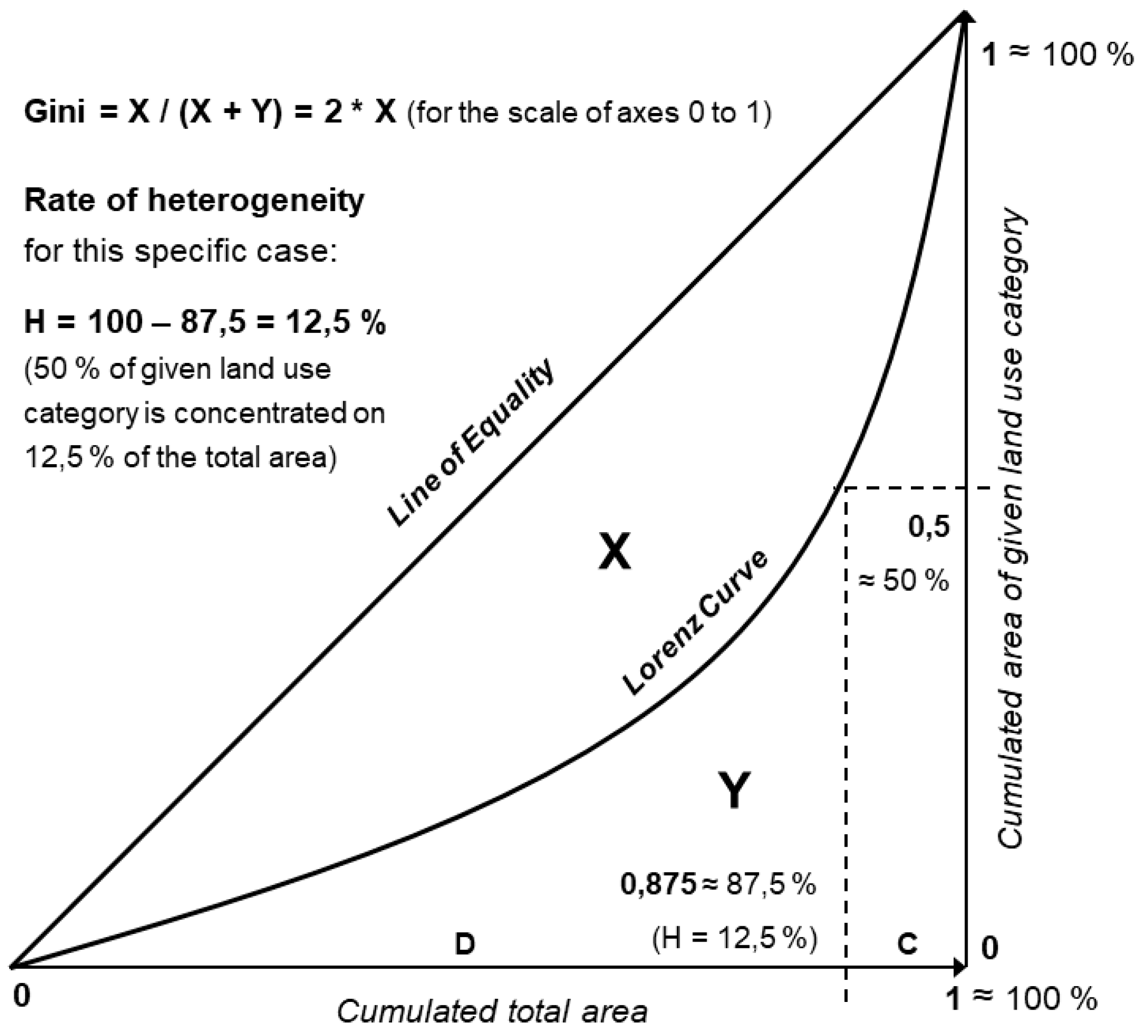
In the first step, we measured overall differentiation of occurrence of the four selected land use categories across Czechia, and its changes between the six-time horizons. We applied two statistical methods: Gini coefficient and Rate of heterogeneity, both based on the Lorenz curve. A Lorenz curve for a given land use category in a given year was constructed from cumulated areas of the given category in BTUs on one axis and cumulated total areas of BTUs on the other axis, with the BTUs sorted by the share of the given category on their total area. Shares of land use categories and total areas of BTUs on Czech total area (100%) can be used instead of areas in hectares (see Figure 1). In geography, Lorenz curve is used to measure regional differentiation (concentration, inequality of distribution) that increases with the distance of the Lorenz curve from the line of equality [45].
Gini coefficient (hence Gini (1)) is a measure of statistical variability, calculated as the ratio of the area lying between the Lorenz curve and the line of equality over the area of the whole triangle lying under the line of equality (see [45]). Gini thus ranges from 0 to 1 with higher values indicating higher differentiation (inequality), as seen in Figure 1.
Rate of heterogeneity (hence H) is a similar, yet simpler method, devised by Hampl (see [10] for an overview). H quantifies value at the 50th percentile of the Lorenz curve [45]. In other words, it expresses the share (%) of the total area covered by BTUs that contain the more concentrated half of the area of the given land use category (see Figure 1). H theoretically ranges from 0% (total inequality) to 50% (total equality of distribution, no differentiation). H divides BTUs into two sets, each containing half of the total area of the given land use category—the “concentrated half” (hence C) with fewer BTUs having a higher share of the given land use category on their area, and the “dispersed half” (hence D) with more BTUs having a lower share of the given land use category on their area (see Figure 1). H is calculated from a data table applying Lorenz curve (see Figure 1).
Gini and H return similar results—with a growing differentiation (concentration, variability), Gini increases from 0 to 1 and H decreases from 50 to 0%. H is less precise because it is only estimated from one point on the Lorenz curve, whereas Gini takes into account the whole shape of the curve. On the other hand, H is less abstract and, more importantly, the two resulting sets of BTUs—C and D—can be visualized in a map, which helps us to understand where precisely (e.g., into what natural and socio-economic conditions) do the individual land use categories concentrate and why.
We calculated Gini and H for the four selected land use categories in the six-time horizons 1845, 1896, 1948, 1990, 2000, and 2010. Consequently, we visualized the “concentrated halves” of BTUs (C) in four maps, each map for one land use category. Three groups of BTUs are displayed in each map. The first group contains those BTUs that lay in C both at the beginning and at the end of the studied period (1845 and 2010)—these BTUs can be seen as stable “cores” of concentration of the given land use category. The second group comprises those BTUs that have “left” C (i.e., BTUs that were in C in 1845 but not in 2010) and the third group contains those BTUs that have “entered” C (i.e., BTUs that were in C in 2010 but not in 1845). There should be more BTUs in the second group than in the third one because the number of BTUs in C should be decreasing with the hypothesized increasing land use differentiation. These two later groups reveal the exact spatial aspects of the changing land use distribution—they show us into which localities have the individual categories tended to concentrate and from where have they tended to disappear. Our aim then is to interpret the spatial pattern of the occurrence of those various sets of BTUs.
2.3. Selected Characteristics of Natural Confitions: Altitude and Slope
In order to assess more accurately the spatial pattern of changing land use differentiation and impacts of structural preconditions of individual regions on it, we included two indicators of natural conditions into our analysis—average altitude and average slope (inclination) of BTUs. These two variables serve as examples of a wide range of quantifiable “proximate factors” ([43,46]) influencing land use pattern. Both have a strong impact on anthropogenic, particularly agricultural use of Czech landscape (e.g., [37,38,39]). Altitude is a main cause of differentiation in climate and soil types, and thus in soil fertility and crop yields, whereas slope has an impact on accessibility and general usability of individual plots.
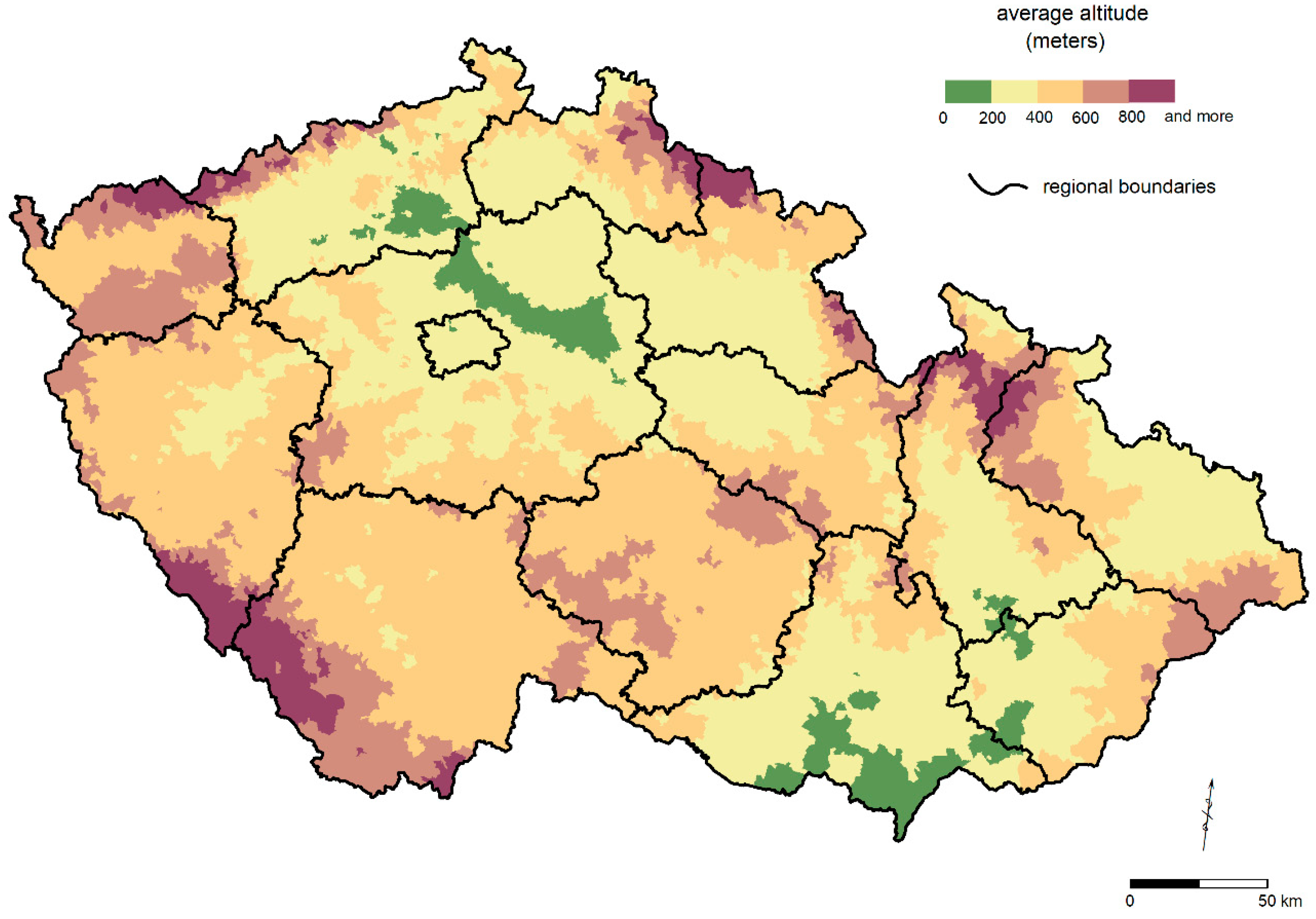
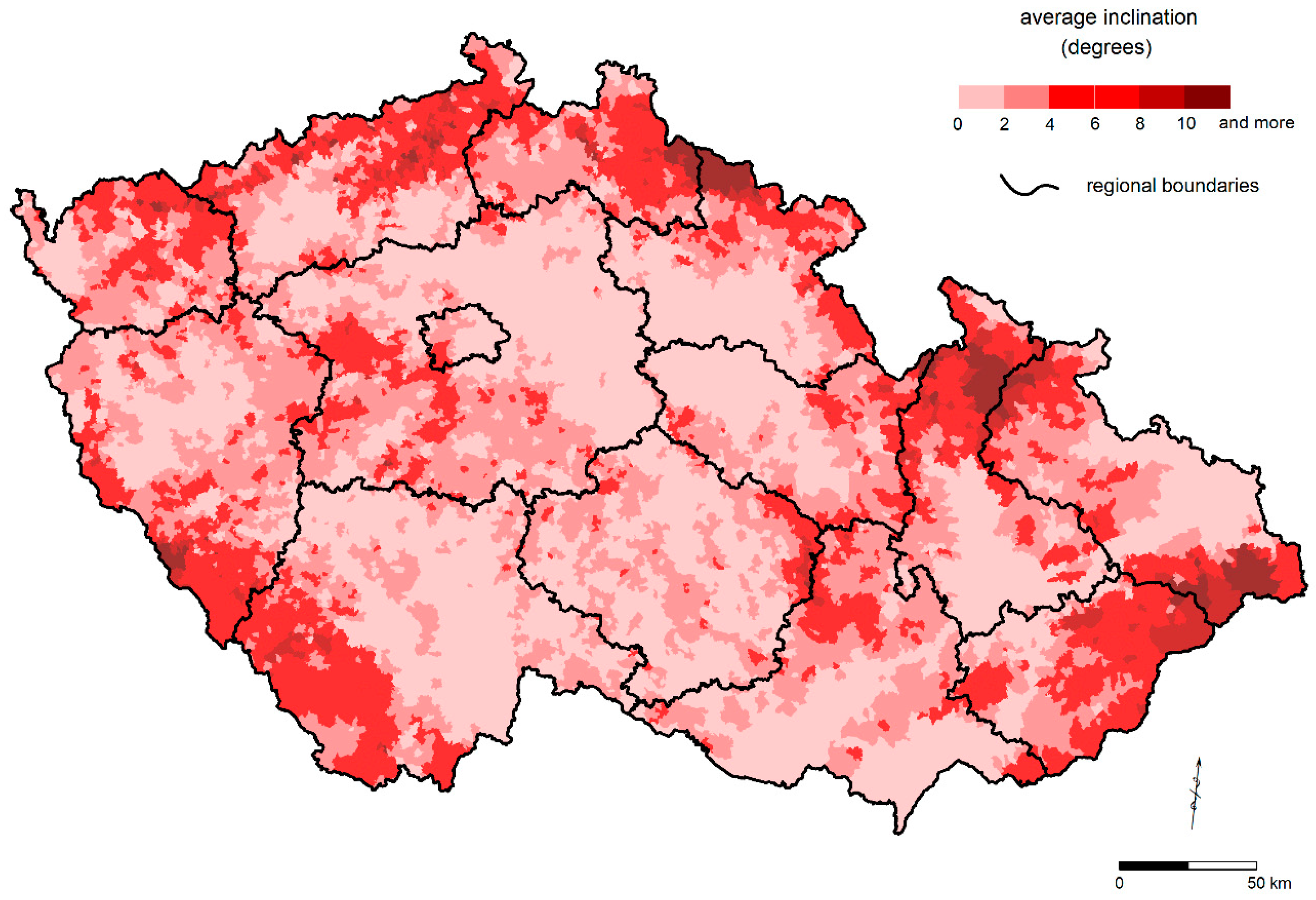
Average altitudes and slopes of BTUs were calculated from a digital terrain model (DTM) of Czechia using interpolation (Spline) in software ESRI ArcGIS (see [38], p. 71 for details). DTM was derived from contour lines (50 m interval) from ArcČR 500 dataset. The territory of Czechia was divided into squares of 50 × 50 m in order to calculate average altitude (meters above the sea level, m.a.s.l.), and into squares of 250 × 250 m to calculate average slope using Slope function in ESRI ArcGIS (degrees, °) respectively. Average altitude and slope of a BTU were then calculated as an arithmetic mean of all pixels located within it, using Zonal Statistics in ESRI ArcGIS [38]. The results can be seen in Figure 2 and Figure 3. Average altitude for the whole Czechia is 442.6 m.a.s.l. and average slope is 2.9°.
Two principal lowlands can be found in Czechia (Figure 2), one in the northwest of the country (northern Bohemia) and the other in the southeast (central and southern Moravia). These two lowlands are separated by Bohemian-Moravian Highland, also known as the “Inner Periphery”. The whole country is then almost completely encircled by a ring of mountains and highlands. Slope (Figure 3) is relatively closely associated with altitude, with some exceptions, e.g., in southern Bohemia and Bohemian-Moravian Highland, which are quite high but rather flat; or in the generally more rugged Carpathian east of the country. Pearson’s correlation between altitude and slope on the level of BTUs reaches R = 0.44 ([38], p. 73), that locally the relation between these two variables is not entirely straightforward.
For our purposes, we calculated average altitudes and slopes of the groups of “concentrated halves” (Cs) of BTUs for each land use category in each time horizon. A gradually decreasing altitude and slope of C for arable land and built-up areas and an increasing altitude and slope of C for grasslands and forests would prove the hypothesized growing concentration of these categories in the respective local conditions, thus increasing influence of natural factors on land use differentiation.
3. Results
Before we get to the analysis of changing land use differentiation, we have to look briefly at the overall land use development in Czechia in the period 1845–2010 (see Table 2). For more information, see, e.g., [11,42,44].
3.1. Overview of Land Use Changes in Czechia
Arable land, grasslands, and forests are the most widespread land use categories in Czechia (Table 2). The extent of arable land reached its long-term peak in the late 19th century, marking the final phases of extensive expansion of agriculture [11]. Then the share of arable land started to decrease continuously, as a result of agricultural modernization that led to a fast growth of intensity (yields) and thus a lesser need for land, and imports of foodstuff and feed [33]. The decline in the area of arable land continued after the Velvet Revolution due to a transformational slump in agricultural production and new environment-friendly agricultural policies, including supports for grassing-over on arable land and maintenance of grasslands, especially in Less Favored Areas (LFAs). As a result, arable land disappeared from more than 13% of Czech territory between 1896 and 2010 (Table 2), and this trend is likely to continue [44].
Similarly, permanent grasslands had suffered a long-term decrease of their area, caused by changes in agricultural practices, including a conversion of animal husbandry that can be simplified as a move from hay to silage and from pastures to stables [9]. However, there occurred a crucial reversal of this trend in the 1990s (Table 2, [8]); the area of grasslands is now increasing thanks to the aforementioned decline of crop farming, replaced by a new system in agro-complex and implementation of EU policies/system of subsidies.
Forested areas increased from 28.9 to 33.7% in 2010 with a significant afforestation after 1896 with acceleration after 1948 due to the expulsion of Czech Germans (more than a quarter of total population of Czechia [42]) after World War II, which caused a large-scale landscape abandonment and afforestation in the border areas. In core areas, a large part of the agricultural land has been turned into land use categories associated with urban areas and intensive human activities, in general—permanent cultures (especially gardens), built-up areas, and “remaining areas”. The “remaining areas” today cover more than 12% of Czechia (Table 2). They contain mainly various impervious, sealed, and generally highly artificial surfaces that add up to the negative environmental effects of the growth of built-up areas. The highest growth of “remaining areas” has been caused by residential and commercial urbanization and suburbanization, new infrastructure development, etc. [44]. Currently, losses of agricultural land, especially of the most fertile soils, constitute a major Czech environmental problem [47].
3.2. Arable Land
Let us turn our attention now to changes in regional pattern of land use. Table 3 confirms the gradually increasing differentiation of distribution of arable land across Czechia. In 1845, half of Czech arable land was concentrated in 35% of the total country area, whereas in 2010, it was only in 29% (Table 3). Differentiation of the share of arable land in Czechia has been particularly growing in the two periods of the most radical economic and political changes (1948–1990 and 1990–2000).
Arable land generally lies in above-average conditions - in lower and flatter areas (Table 3). The influence of natural conditions on the distribution of arable land has been growing—arable land has continued to concentrate into lower altitudes and, more significantly, into less steep areas (Table 3). The total area of Czech arable land has been decreasing (Table 2), and the influence of slope on the spatial pattern of this process was crucial—arable land has tended to disappear dominantly from more rugged, broken terrain. In 1845, average slope of the “concentrated half” of the total area of arable land was 2.2°, whereas in 2010, it was 1.7° (Table 3). This process was strongest in the socialist period (1948–1990), probably as a result of large-scale mechanization of agriculture that rendered the use of steeper lands as arable fields technically impossible [39].
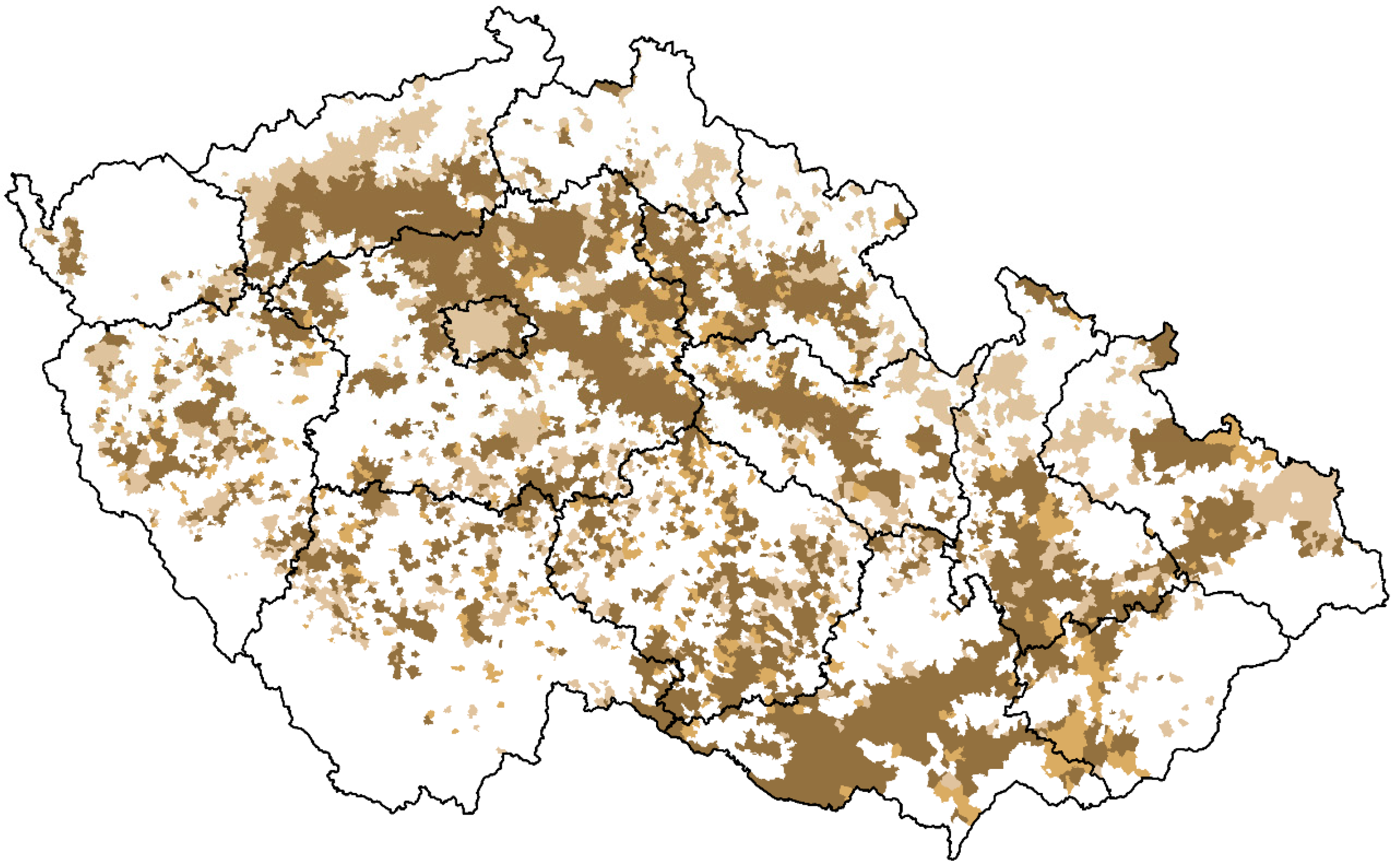
Figure 4 confirms that arable land is primarily concentrated in lowlands. This pattern has been strengthened since 1845. Most of the few BTUs that “entered” C can be found within or on the edges of the two main lowlands (eastern Bohemia, central Moravia) and they are almost invariably adjacent to the “stable” BTUs. Therefore, the two “core” regions of arable land in Czechia are now spatially more compact (Figure 4). On the other hand, the number of BTUs that “left” C is larger. These BTUs lie prevailingly in average natural conditions in highlands and at the foothills of mountains, especially in the northern part of the country (Figure 4), where the once-abundant arable land has tended to be grassed-over, afforested or abandoned. In metropolitan zones (e.g., around the cities of Prague and Ostrava) arable land was developed, and, similarly, also the regions with large-scale surface coalmining (e.g., NW Bohemia) suffered from a massive destruction of agricultural landscape in the era of communism (1948–1990).
3.3. Permanent Grasslands
The differentiation of distribution of grasslands is distinctly higher than this of arable land (compare Table 3 and Table 4). Permanent grasslands have also undergone a stronger spatial concentration. The share of Czech territory comprising half of the country’s grasslands has shrunk from 31% in 1845 to 22% in 2010 (Table 4). The differentiation of the share of grasslands was rising steadily between 1845 and 2010, with the peak in the socialist period again.
Grasslands predominantly occupy below-average natural conditions with higher altitudes and steeper slopes (Table 4). Again, this feature has been gradually strengthened since the 1840s, particularly in regard to slope. The total area of permanent grasslands in Czechia has decreased (Table 2) and the spatial pattern of this was strongly driven by slope—in 1845, BTUs comprising the “concentrated half” of Czech grasslands had average slope of 3.2°, whereas in 2010, it was 4.5° (Table 4). The era of socialism (1948–1990) is interesting. The influence of altitude (and thus of climate and soil fertility) on the distribution of grasslands decreased slightly (Table 4), suggesting a lack of interest in the effectiveness of farming and general irrationality of (spatial) decision-making in the centrally planned economy. On the other hand, the influence of slope rose rapidly (Table 4), likely due to the above-mentioned mechanization of agriculture.
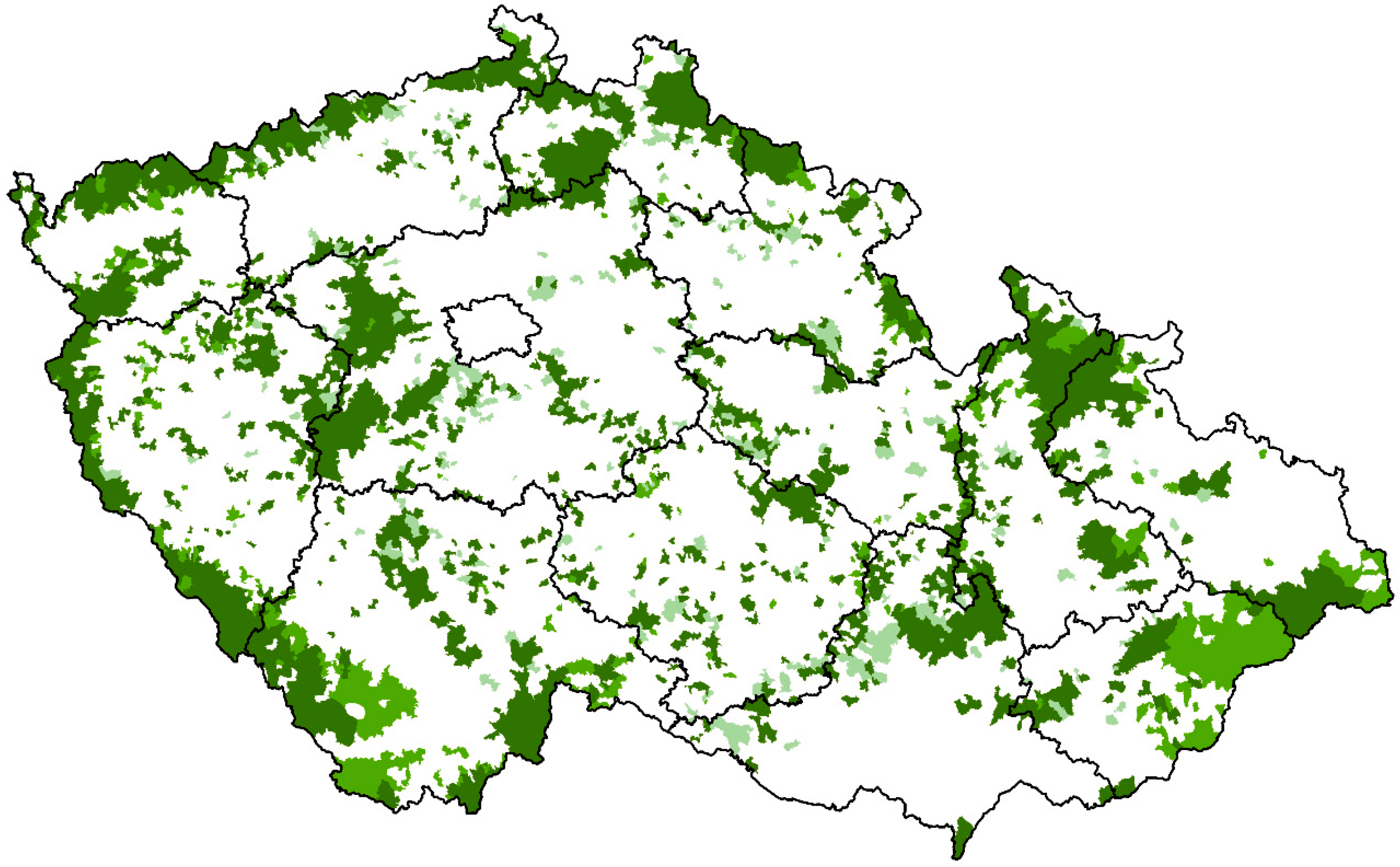
Figure 5 confirms the concentration of permanent grasslands into worse natural conditions, i.e., into the border mountain ranges and parts of the central Bohemian-Moravian Highland. The map also shows a massive regional redistribution of grasslands between 1845 and 2010, much stronger than this of arable land (compare Figure 4 and Figure 5).
Distribution of the vast number of BTUs that “left” C suggest a strong shrinkage or virtual disappearance of grasslands from lowlands (southern Moravia, central Bohemia) and lower highlands (parts of Bohemian-Moravian Highland, eastern and southern Bohemia). On the other hand, the BTUs that “entered” C between 1845 and 2010 are less numerous and can be found mostly in mountains and higher highlands, particularly in the northern part of the country (Figure 5). As a result, the area covered by BTUs comprising the “concentrated half” of Czech grasslands is now spatially more compact and more confined to worse natural conditions.
3.4. Forested Areas
The differentiation of distribution of forested areas is rather high (compare Table 5 with Table 3 and Table 4) but, surprisingly and in contrary to our expectations, it has been decreasing (Table 5). This process, that could be with certain simplification described as “homogenization” or even “diffusion” (because of the growth of the total area of forests in Czechia, Table 2), was, however, rather small and thus should be interpreted cautiously. In 1845, half of Czech forests was concentrated in 24% of the country’s area, whereas in 2010, it was in 26% (Table 5). Moreover, the overall decrease in the differentiation was mostly confined to the period 1896–1990, and before and after that it more or less stagnated (Table 5).
In general, changes in both Gini and H between 1845 and 2010 were smaller for forests than for arable land and grasslands (compare Table 5 with Table 3 and Table 4). It proves that forests are more stable not only in their total extent (Table 2) but also in their regional distribution. This is understandable because the transitions within the agricultural land (between arable land and grasslands) are technically simple, easily reversible, and can be seen as a matter of year-to-year decisions. To the contrary, a transition between agricultural land and forest is technically complex, hard to reverse, with long-term consequences and requiring more robust decision-making and reasons.
Forested areas prevailingly lie in less favored natural conditions with higher altitudes and, more importantly, steeper slopes (Table 5). Despite the decrease in the differentiation of their distribution, the influence of natural conditions has been further growing as predicted. In other words, the afforestation (Table 2) was prevailing in higher and especially steeper regions—in 1845, the average slope of all BTUs with the “concentrated half” of Czech forests was 4.7°, whereas in 2010, it was 5.2° (almost twice the country’s average, Table 5). This trend was strongest during the socialist period (1948–1990).
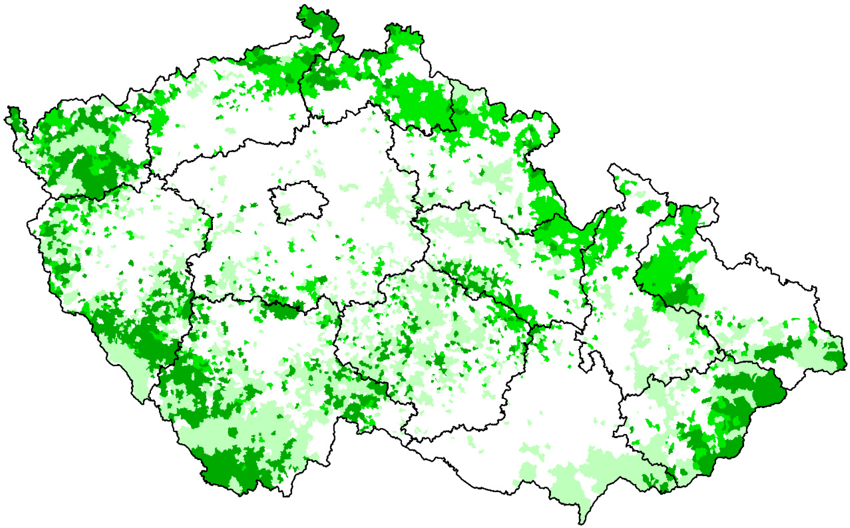
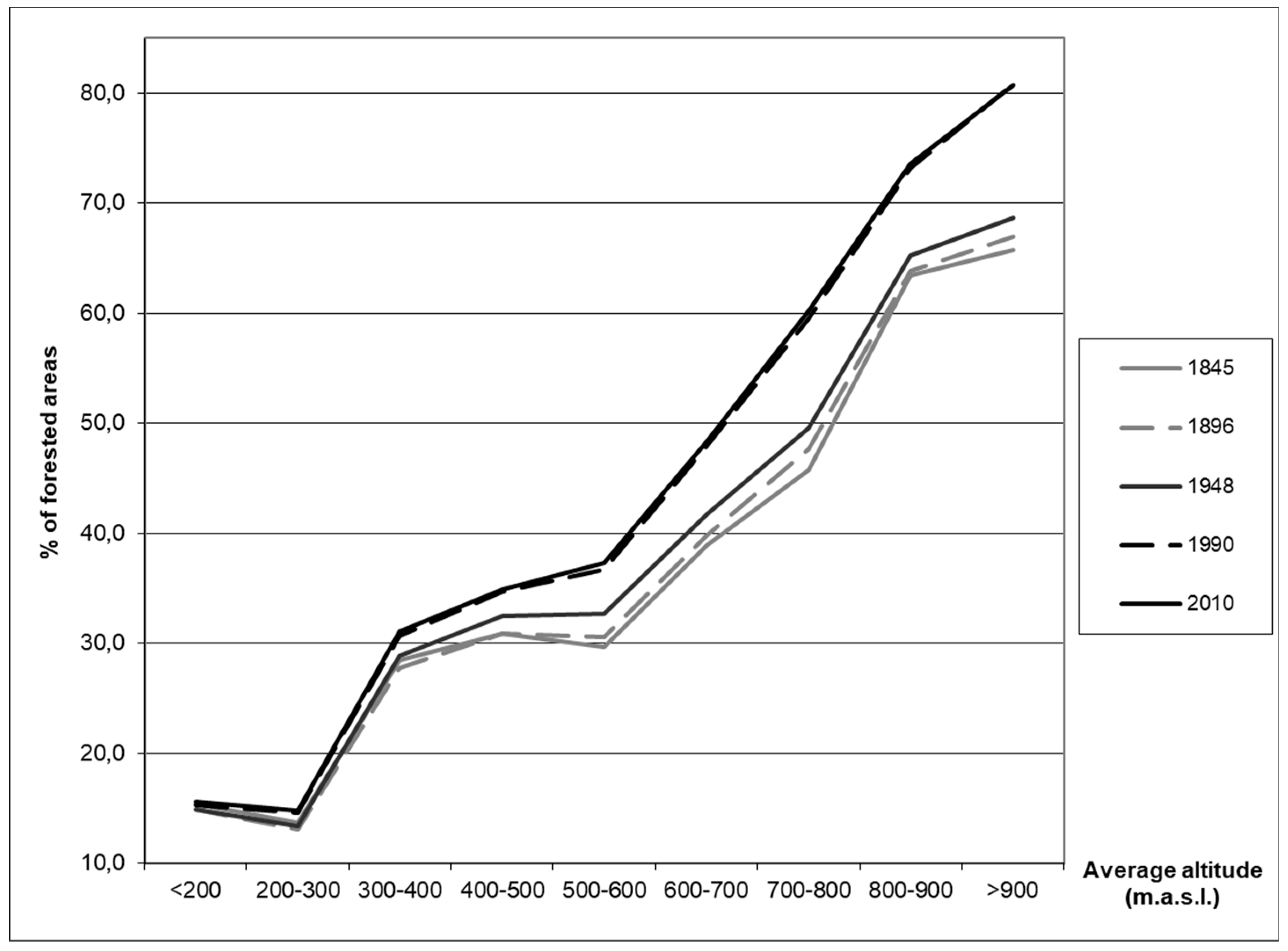
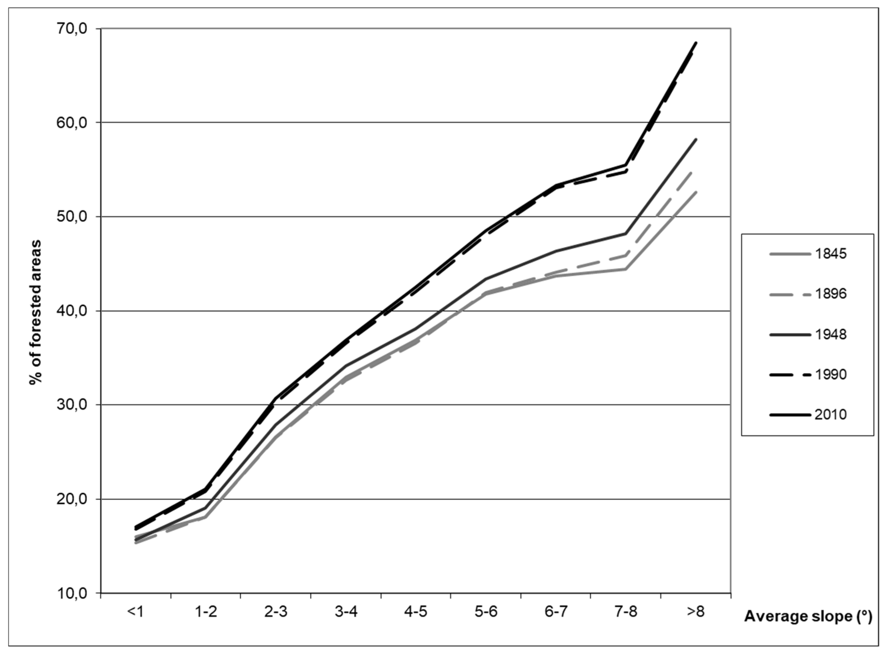
The decreasing differentiation of the distribution of forests coupled with their continuing concentration in below-average natural conditions requires further examination. Therefore, we calculated the average share (%) of the forested areas in groups of BTUs defined by their average altitude (Figure 6) and average slope (Figure 7). It is clear from both graphs that the forests are continuously increasing their share in the areas at higher altitudes and with higher inclinations more and more. If we compare the percentages of the forests in the areas with lower and higher altitudes and lower and higher slopes in 1845 and 2010, we find that the differences in the forest share in the areas less inclined at lower altitudes are not significant, unlike the more inclined and mountainous areas where the forests have significantly increased their share (by more than 15%). Figure 8 confirms the concentration of the forests into the mountains of Czechia, e.g., the mountain ranges in the border areas or parts of the central Bohemia (Brdy) and Moravian Highlands (Zelezne hory). The steepest areas outside the highest mountains are also noticeable, e.g., the steepest valleys along the Vltava river. The map (Figure 8) also shows the relative stable distribution of forests during the whole observed period of 1845–2010 with the gradual concentration of the forests into the less favored areas. The BTUs that “entered” C between 1845 and 2010 can be found mostly in the mountains and the sub-mountain areas. A lower dynamic of changes in the forests is visible if the changes in the distribution of the forested areas and grasslands are compared (compare Figure 5 and Figure 8).
3.5. Built-Up Areas
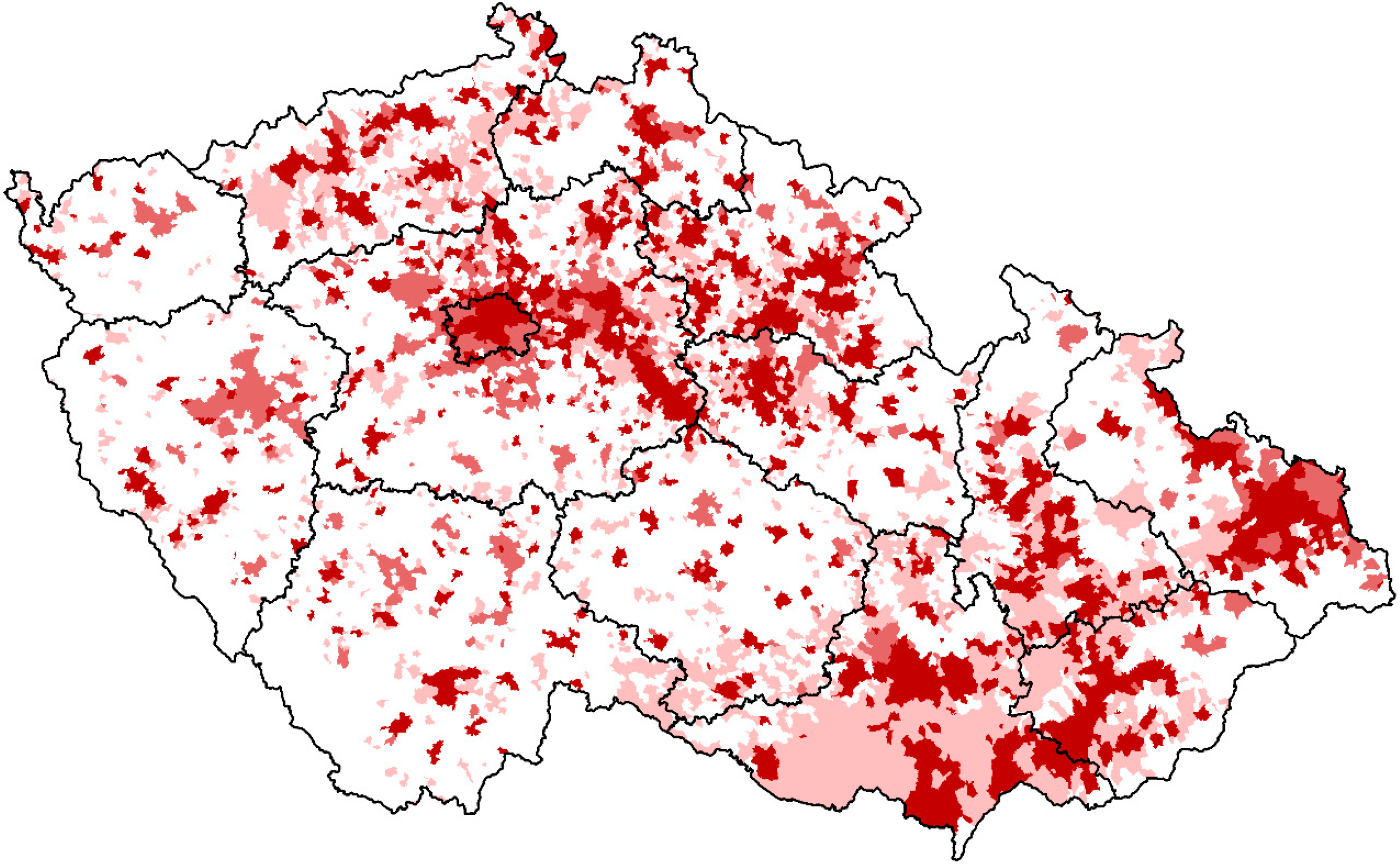
The category of built-up areas is important in terms of the investigation of intensive human activities (a settlement system or economic activity). Table 6 confirms the gradually increasing differentiation of the distribution of the built-up areas across Czechia with a strong acceleration after the year 1948. In 1845, half of the Czech built-up areas were concentrated in 31% of the total country area, whereas in 2010, it was in 21% (Table 6). Figure 9 illustrates the formation of the nodal/core regions and the gradual concentration of the built-up areas into these regions, to the most important centers of settlement (main regional and district towns) and industrial regions (northwest Bohemia and northeast Moravia). The industrialization and urbanization/suburbanization processes were the main drivers of the polarized development. While the core areas have increased their relevance, many inhabitants have left the peripheral/rural areas, and it has strongly marginalized these regions. This trend was supported by the expulsion of Czech Germans after World War II, which mostly inhabited the border, mountain, and sub-mountain areas. In the long term, there is a clear trend towards the concentration of the built-up areas in the areas with more favorable natural conditions. The calculated altitudes and inclinations for the concentrated half of BTUs (C) decreased when compared to the initial (1845) and end year (2010). However, the development since 1948 is somewhat specific, and values of the both characteristics have been gradually increasing (Table 6). This may be due to the fact that a significant part of the residential construction has been built up in the outskirts (suburban zones) of the cities in environmentally better localities in recent decades. These areas have mostly a more rugged relief.
4. Discussion
The long-term trends in environmental geographical inequality (the spatial and temporal distribution of land use categories) were analyzed based on the time series of the cadaster level data going well back into the half of the 19th century. Our intent was to provide an integrated approach by considering several land use variables, factors, and patterns across several temporal scales.
For the examination of the differentiation/inequality of the land use changes, we applied the “rate of heterogeneity” (H). It corresponds to the point on the Lorenz curve defined by the 50th percentile of the characteristic under consideration. In order to assess the spatial pattern of changing land use differentiation and impacts of structural preconditions more accurately, we used two indicators of natural conditions into our analysis—altitude and slope (inclination). This methodology approach seems to be very useful, not only for an evaluation of the differentiation of the land use changes but for definition of the driving forces, as well. The used methods focused on an evaluation of the spatial pattern of the nature–society interaction and its development [10]. The methods were used to calculate the changes in the areas of the concentrated half of the monitored category, as well as the localization of the territorial units in which these concentration processes took place. If working in the GIS environment, we are able to define where the observed phenomena occurred and, furthermore, we are able to define the basic geographical characteristics of these areas. For this study, the average altitudes and inclinations were modeled in GIS for all the units studied. This data is very useful for synthetically identifying the causes of the land use change differences as they define in what typological locations the category was concentrated for us during the reporting periods. This gives us an overview of the area in which the land use categories were concentrated in each of the years under review and how these areas were characteristic. This approach could serve as an example of a method for quantifying the factors (driving forces) of an influential land use pattern [8,46].
The results documented a strong trend in the differentiation of the long-term land use changes. The influence of natural conditions on the distribution of the arable land has been growing, and the arable land has continued to be concentrated into lower altitudes and, more significantly, into less steep areas (Table 3). In 1845, the average slope of the “concentrated half” of the total area of arable land was 2.2°, whereas in 2010, it was 1.7° (Table 3). This process was strongest after 1948, probably as a result of the large-scale mechanization of the agriculture [39]. The total area of permanent grasslands in Czechia has decreased (Table 2). Grasslands predominantly occupied below-average natural conditions. The spatial pattern of this was strongly driven by the slope—in 1845, the units comprising the “concentrated half” of the Czech grasslands had an average slope of 3.2°, whereas in 2010, it was 4.5° (Table 4). This can probably be attributed to radical changes in farming practices in the course of industrialization of agriculture, i.e., to a spatial separation of crop farming and animal husbandry [18]. Pastures and meadows are now not needed on intensive farms in better and average natural conditions. The forested areas are prevailingly concentrated in less favored natural conditions, as well (Table 5). Afforestation prevailed in the higher and especially steeper regions—in 1845, the average slope of all the units with the “concentrated half” of the Czech forests was 4.7°, whereas in 2010, it was 5.2° (almost twice the country’s average, Table 5). Again, this trend was strongest after World War II probably as a result of the mentioned mechanization of the agriculture, and also from the post-war expulsion of Czech Germans from the border mountain ranges, where the afforestation or spontaneous succession were strongest [41,42]. Intensive human activities represented by the built-up areas have been strongly concentrated and polarized. Our results confirmed the gradually increasing differentiation of the distribution of the built-up areas across Czechia. In 1845, half of the Czech built-up areas were concentrated in 31% of the total country area, whereas in 2010, it was in 21% (Table 6). From a regional point of view, the ever-increasing importance of the main centers of settlement and industrial regions and the gradually formed nodality of socio-economic regions [10] are evident. The built-up areas are increasingly concentrated in these regions. In terms of the spatial pattern, one can observe the lowlands with lower altitudes on the one hand, and the higher altitudes of the foothills and mountains bordering the Czech border on the other hand. In the long term, the process of intensifying the land use in the lower altitudes (increasing the intensity of the agriculture and developing the built-up and other urban areas and suburban areas) is evident, while abandonment of the arable land, concentration of the permanent grassland and afforestation in the higher altitudes. The processes of decreasing the area of agricultural and arable land and its concentration into favorable areas, where modern agricultural practices are intensively managed, are characteristic of countries with a modern developed economy, such as those in developed European countries. As Mather [46] explains, it is related to the development of the functioning of modern society, where market mechanisms and an increasingly open global market play a key role in the different functional use of European countries.
The overall trend of land use development in the Czechia between 1845 and 2010 documents the gradual formation of typological regions of similar structure of areas and its development. These regions are composed of territorial units with similar land use structure. This situation stems from the different functions that society, managed from an increasingly high level (not local, as in 1845 and earlier), gives to the individual regions in which these typological regions are formed. The functions that formed these typological regions were varied, some of which were formed in the later stages of the development of society (recreational, water management, environmental). Others, such as residential functions (built-up areas and other areas), worked during all the periods examined but with a very different regional impact and intensity. It is the increase in the metropolitan and urban regions and, recently, also their extension to the outskirts—the formation of suburbs. The rural landscape was strongly differentiated. The intensively used lowlands, in which arable land “competes” in the core areas with residential and transport areas. Extensive agriculture, recreational, water management, and environmental functions play the main role in peripheral areas.
Different driving forces influenced the differentiation in the land use changes and the extent of the land use categories monitored in the different periods. Some historical stages are dominated by political drivers (agrarian reform after the establishment of Czechoslovakia, World War II associated with massive population movements—the expulsion of Czech Germans, the communist coup in 1948, the creation of the Iron Curtain, the accession of the Czechia to the EU, etc.) the economic driving forces (nationalization after 1948, restitution and privatization after 1989). However, it is very difficult to distinguish between the individual driving forces, but their combination is predominant [6,43]. In the case of the Czechia, it is generally necessary to emphasize the predominance of the political and economic drivers for the land use changes, with an influence of the natural conditions creating a specific regional pattern of these changes [29,33,42].
Our results of the differentiation of long-term land use changes validated the theory of “differential rent” (DR). Especially, land use patterns since 1896 have been strongly influenced by the DR II. DR II much enhanced the importance of geographical location as such [11]. DR II is inevitably linked to use of more advanced agricultural technologies and to growing cooperation between farmers on one side and various industries (machinery, chemical industry) on the other side. In such a way, agricultural–industrial complex gradually came into existence. New technologies included use of fertilizers, modern machines, and energy sources, as well as drainage, irrigation, terraced fields, etc. The intensification of farming that started in the second half of 19th century accentuated the importance of DR II, i.e., capital investments into existing plots. Most money was naturally invested into areas with higher DR I that were more fertile and easily accessible [48]. This synergy between DR II and DR I increased the regional inequalities of land use patterns. In a free market economy, the effects of DR are beyond dispute. The land use changes that occurred in 1948–1990 had different trends in some aspects because they were influenced by centrally-planned economy. However, land use changes that have occurred since 1990 in Czechia verified this hypothesis [44,48].
The study verified the concept of “forest transition”, as well. Decrease of forest areas was typical for the early modern history. It was caused by growing population (proximate factor) and rather primitive agricultural practices (intermediate factor) which required more and more agricultural land and led to deforestation [30,43]. This trend, however, changed at the end of nineteenth century and forests began to expand, though at the same time population was still growing. The dynamic increase of the forest areas was documented after 1896; before that it more or less stagnated in Czechia (Table 5). The influence of population growth as a proximate factor reversed due to changing nature of intermediate factors—more advanced agricultural practices (which made possible to cultivate less land) and decreasing demand for wood which was gradually replaced by other materials (iron, concrete, fossil fuels) [49]. Forested areas have gradually concentrated in less favored natural conditions with higher altitudes and, more importantly, steeper slopes (Table 5). This trend was mainly evoked by the industrialization and large-scale mechanization of agriculture that rendered the use of steeper lands as agricultural land technically impossible and unprofitable [39]. The political drivers (e.g., the expulsion of Czech Germans and the creation of the Iron Curtain) strengthened the expansion of new forest, especially in the border areas of Czechia [42]. These trends can be seen as prevailingly environmentally positive, for they should, at least in theory, reduce the risk of soil erosion or floods and support carbon sequestration and ecosystem services, in general [34].
If the obtained results are compared with similarly oriented studies, it is possible to find several common trends. Hurbanek [50] evaluated the land use changes and the development of settlements in peripheral areas and found a significant correlation between the depopulation and the decrease in the land use intensity with the mountainous and sub-mountainous character of the relief. The trends of polarization of the land use changes related to the abandonment of the agricultural land in less favored areas and to the concentration of human activities in favorable (exposed) areas were shown by the results of Slovenian authors (Gabrovec and Kladnik [24]) and by the research carried out in Austria [18].
When critically assessing the methodology and the used data, a negative point related to the cadaster data used in this study should be mentioned. The reliability of the cadaster records referring to the land use has decreased since 1990. A high ratio of agricultural land is rented in Czechia and some changes could have occurred on the agricultural land without recording it in the cadastral data. On the other hand, we performed a robust analysis covering the whole territory of Czechia and analyzed more than 8000 units, so the effect of the lower reliability of the cadaster data after 1990 should not have a significant effect on the results of the general trends of the land use changes in such a long-term period.
Finally, there are a number of proposals for follow-up research such as widening the case studies or to add other relevant data in the analysis of differentiation (e.g., population data), which could enable a deeper analysis of the driving forces. Furthermore, an approach based on qualitative research, e.g., interviews with the main local players (farmers, institutions, etc.) could produce interesting and useful information and verify the results of this study.
5. Conclusions
The major topic of this article is the evaluation of the regional differentiation of the long-term changes in land use in Czechia. This study sought to contribute to the research of land use on the empirical analysis of differentiation/inequality of the long-term land use changes. The geographical inequality was considered across several temporal scales in relation to the selected variables (attitudes and slope). The chief benefit of this article can be seen in the methodical procedures of the application of the “Rate of heterogeneity” (H) derived from the Gini coefficient in the research of the differentiation/inequality of the long-term land use change. The results documented a strong trend in the differentiation of the long-term land use changes. Two main antagonistic processes took place in the land use structure during the observed period from 1845–2010. Fertile regions experienced agricultural intensification with the concentration of the arable land in these regions. On the other hand, infertile regions experienced extensification, accompanied by an intensive decline in the arable land and grass planting during the last decades. The beginning of the abandonment of the arable land in unfavorable areas and, on the other hand, the concentration into fertile areas should be considered at the turn of the 19th and 20th centuries, when the aspects of differential rent [11] began to have a significant effect. The influence of the slope on the spatial pattern was crucial—the arable land has tended to disappear dominantly from the more rugged terrain. The main trends of land use changes document the gradual formation of typological regions of similar land use structure and nature conditions. These regions are composed of territorial units with similar development. Different driving forces influenced the differentiation in the land use changes and the extent of the land use categories monitored in the different periods. In the case of the Czechia, it is generally necessary to emphasize the predominance of the political and economic drivers for the land use changes, with an influence of the natural conditions creating a specific regional pattern of these changes.
Author Contributions
Conceptualization, P.S., I.B., J.L. and J.K.; methodology, P.S., J.L., I.B. and J.K.; software, P.S. and J.L.; validation, P.S, J.L., I.B., J.K.; investigation, P.S. and J.K.; resources, J.K., J.L. and P.S.; data curation, P.S., J.L., J.K. and I.B.; writing—original draft preparation, J.K., P.S., and I.B.; visualization, J.L., J.K. and P.S.; supervision, I.B.
Funding
We would like to thank for the support of the Ministerstvo kultury ČR, NAKI II, Project no. DG18P02OVV065 (Živá mapa: Topografie dějin přírodních věd v českých zemích).
Conflicts of Interest
The authors declare no conflict of interest and the funders had no role in the design of the study; in the collection, analyses, or interpretation of data; in the writing of the manuscript, or in the decision to publish the results.
References
- Foley, J.A.; DeFries, R.; Asner, G.P.; Barford, C.; Bonan, G.; Carpenter, S.R.; Chapin, F.S.; Coe, M.T.; Daily, G.C.; Gibbs, H.K.; et al. Global Consequences of Land Use. Science 2005, 309, 570–574. [Google Scholar] [CrossRef] [Green Version]
- Steffen, W.; Noone, K.; Chapin, F.S.I.; Lambin, E.; Scheffer, M.; Folke, C.; Schellnhuber, H.J.; Hughes, T.; Van Der Leeuw, S.; Rodhe, H.; et al. Planetary Boundaries: Exploring the Safe Operating Space for Humanity. Ecol. Soc. 2009, 14. [Google Scholar] [CrossRef]
- Ramankutty, N.; Evan, A.T.; Monfreda, C.; Foley, J.A. Farming the planet: 1. Geographic distribution of global agricultural lands in the year 2000. Glob. Biogeochem. Cycles 2008, 22. [Google Scholar] [CrossRef]
- Peng, G.; Le, Y.; Congcong, L.; Jie, W.; Lu, L.; Xuecao, L.; Luyan, J.; Yuqi, B.; Yuqi, C.; Zhiliang, Z. A new research paradigm for global land cover mapping. Ann. GIS 2016, 22, 87–102. [Google Scholar] [CrossRef] [Green Version]
- Aspinall, R.J.; Hill, M.J. Land Use Change. Science, Policy and Management; CRC Press: Boca Raton, FL, USA, 2008; p. 185. [Google Scholar]
- Geist, H. Our Earth’s Changing Land: An Encyclopedia of Land-Use and Land-Cover Change; Greenwood Press: Westport, CT, USA, 2006; p. 716. [Google Scholar]
- Koomen, E.; Stillwell, J.; Bakema, A.; Scholten, H.J. Modelling Land-Use Change. Progress and Applications; Springer: Dordrecht, The Netherlands, 2007; p. 398. [Google Scholar]
- Lambin, E.F.; Geist, H. Land-Use and Land-Cover Change. Local Processes and Global Impacts; Springer: Berlin/Heidelberg, Germany; New York, NY, USA, 2006; p. 222. [Google Scholar]
- Meyer, W.B.; Turner, B.L., II. Changes in Land Use and Land Cover: A Global Perspective; Cambridge University Press: Cambridge, UK, 1994; p. 549. [Google Scholar]
- Hampl, M. Reality, Society and Geographical/Environmental Organization: Searching for an Integrated Order; Charles University in Prague, Faculty of Science: Prague, Czechia, 2000; p. 112. Available online: https://www.natur.cuni.cz/geografie/socialni-geografie-a-regionalni-rozvoj/other/files/hampl-realita-spolecnost (accessed on 1 March 2019).
- Jeleček, L. Historical development of society and LUCC in Czechia 1800-2000: Major societal driving forces of land use changes. In Land Use/Land Cover Changes in the Period of Globalization; Bičík, I., Ed.; Charles University in Prague, Faculty of Science: Prague, Czechia, 2002; pp. 44–57. [Google Scholar]
- Grigg, D. An Introduction to Agricultural Geography, 2nd ed.; Routledge: London, UK; New York, NY, USA, 1995; p. 217. [Google Scholar]
- DeFries, R.S.; Foley, J.A.; Asner, G.P. Land-use choices: Balancing human needs and ecosystem function in a nutshell. Front. Ecol. 2004, 2, 249–257. [Google Scholar] [CrossRef]
- Lambin, E.F.; Meyfroidt, P. Land use transitions: Socio-ecological feedback versus socio-economic change. Land Use Policy 2010, 27, 108–118. [Google Scholar] [CrossRef]
- Mather, A.S. The forest transition. Area 1992, 24, 367–379. [Google Scholar]
- Meyfroidt, P.; Lambin, E.F. Global forest transition: Prospects for an end to deforestation. Annu. Rev. Environ. Resour. 2011, 36, 343–371. [Google Scholar] [CrossRef]
- Lambin, E.F.; Turner, B.L.; Geist, H.J.; Agbola, S.B.; Angelsen, A.; Bruce, J.W.; Coomes, O.T.; Dirzo, R.; Fischer, G.; Folke, C.; et al. The causes of land-use and land-cover change: Moving beyond the myths. Glob. Environ. Chang. 2011, 11, 261–269. [Google Scholar] [CrossRef]
- Krausmann, F.; Haberl, H.; Schulz, N.B.; Erb, K.H.; Darge, E.; Gaube, V. Land-use change and socio-economic metabolism in Austria—Part I: Driving forces of land-use change 1950–1995. Land Use Policy 2003, 20, 1–20. [Google Scholar] [CrossRef]
- Sporrong, U.; Ekstam, U.; Samuelsson, K. Swedish Landscapes; Swedish Environmental Protection Agency: Stockholm, Sweden, 1996.
- Zullo, F.; Fazio, G.; Romano, B.; Marucci, A.; Fiorini, L. Effects of urban growth spatial pattern (UGSP) on the land surface temperature (LST): A study in the Po Valley (Italy). Sci. Total Environ. 2019, 650, 1740–1751. [Google Scholar] [CrossRef] [PubMed]
- Falcucci, A.; Maiorano, L.; Boitani, L. Changes in land-use/land-cover patterns in Italy and their implications for biodiversity conservation. Landsc. Ecol. 2007, 22, 617–631. [Google Scholar] [CrossRef]
- Correia, T.P. Land Abandonment: Changes in the Land Use Patterns around the Mediterranean Basin; CIHEAM-IAMZ: Zaragoza, Spain, 1993; pp. 97–112. [Google Scholar]
- MacDonald, D.; Crabtree, J.R.; Wiesinger, G.; Dax, T.; Stamou, N.; Fleury, P.; Gutierrez Lazpita, J.; Gibon, A. Agricultural abandonment in mountain areas of Europe: Environmental consequences and policy response. J. Environ. Manag. 2000, 59, 47–69. [Google Scholar] [CrossRef]
- Gabrovec, M.; Kladnik, D. Some new aspects of Land Use in Slovenia. Geogr. Sb. Acta Geogr. 1997, 37, 7–64. [Google Scholar]
- Oťaheľ, J.; Feranec, J.; Šúrl, M.; Husár, K. Land cover of Slovakia: Assessment of its changes. In Land Use/Land Cover Changes in the Period of Globalization; Bičík, I., Ed.; Charles University in Prague, Faculty of Science: Prague, Czechia, 2002; pp. 100–109. [Google Scholar]
- Amato, F.; Tonini, M.; Murgante, B.; Kanevski, M. Fuzzy definition of Rural Urban Interface: An application based on land use change scenarios in Portugal. Environ. Model. Softw. 2018, 104, 171–187. [Google Scholar] [CrossRef]
- Hamre, L.N.; Domass, S.T.; Austad, I.; Rydgren, K. Land-cover and structural changes in a western Norwegian cultural landscape since 1865, based on an old cadastral map and a field survey. Landsc. Ecol. 2007, 22, 1563–1574. [Google Scholar] [CrossRef]
- Lipský, Z. Present land use changes in the Czech cultural landscape: Driving forces and environmental consequences. Morav. Geogr. Rep. 2001, 9, 2–14. [Google Scholar]
- Lipský, Z. Present Changes in European Rural Landscapes. In Landscape Modelling: Geographical Space, Transformation and Future Scenarios; Urban and Landscape Perspectives Series; Springer: Berlin/Heidelberg, Germany, 2010; Volume 8, pp. 13–27. [Google Scholar]
- Mather, A.S.; Needle, C.L. The forest transition: A theoretical basis. Area 1998, 30, 117–124. [Google Scholar] [CrossRef]
- Romportl, D.; Chuman, T.; Lipsky, Z. Landscape typology of Czechia. Geografie 2013, 118, 16–39. [Google Scholar] [Green Version]
- Lipský, Z. Nová Divočina v Kulturní Krajině? Fyzickogeografický Sborník; Masarykova Univerzita: Brno, Czechia, 2007; pp. 134–142. ISBN 978-80-210-4508-8. [Google Scholar]
- Grešlová-Kušková, P. A case study of the Czech agriculture since 1918 in a socio-metabolic perspective—From land reform through nationalisation to privatisation. Land Use Policy 2013, 30, 592–603. [Google Scholar] [CrossRef]
- Lorencová, E.; Frélichová, J.; Nelson, E.; Vačkář, D. Past and future impacts of land use and climate change on agricultural ecosystem services in the Czech Republic. Land Use Policy 2013, 33, 183–194. [Google Scholar] [CrossRef]
- Kabrda, J. The changing spatial structure of agricultural land use in Czechia since the mid-19th century. Geogr. Časopis 2008, 60, 255–278. [Google Scholar]
- Kabrda, J. Structure of Agricultural Land Use in the Czech Republic. In Land Use/Cover Changes in Selected Regions in the World; IGU-LUCC Research Reports; Bičík, I., Ed.; IGU-LUCC, Charles University in Prague: Prague, Czechia, 2010; Volume V, pp. 31–39. [Google Scholar]
- Mareš, P.; Štych, P. Historical changes of Czech landscape 1845–2000 and their natural and social driving forces studied at different spatial levels. In Understanding Land-Use and Land-Cover Change in Global and Regional Context; Milanova, E., Ed.; Science Publisher: Enfield, NH, USA, 2005; pp. 107–134. [Google Scholar]
- Štych, P. Comparative analysis of the impact of slope inclination and altitude on long-term land use changes in Czechia. AUC Geogr. 2011, 46, 71–76. [Google Scholar] [CrossRef] [Green Version]
- Kabrda, J. Influence of natural conditions on land use in the Vysočina region and its changes since the mid-19th century. AUC Geogr. 2004, 39, 15–38. [Google Scholar]
- Bičík, I.; Kabrda, J. Land use changes in Czech border regions (1845–2000). AUC Geogr. 2007, 42, 23–52. [Google Scholar]
- Bičík, I.; Kabrda, J.; Najman, J. Land-Use Changes along the Iron Curtain in Czechia. In Landscape Modelling: Geographical Space, Transformation and Future Scenarios; Urban and Landscape Perspectives Series; Springer: Berlin/Heidelberg, Germany, 2010; Volume 8, pp. 71–85. [Google Scholar]
- Bičík, I.; Jeleček, L.; Štěpánek, V. Land Use Changes and Their Societal Driving forces in Czechia in 19th and 20th Centuries. Land Use Policy 2001, 18, 65–73. [Google Scholar] [CrossRef]
- Lambin, E.F.; Geist, H. Causes of land-use and land-cover change. In Encyclopedia of Earth; National Council for Science and the Environment: Washington, DC, USA, 2007; Available online: http://www.eoearth.org/article/Causes_of_land-use_and_land-cover_change (accessed on 12 December 2018).
- Bičík, I.; Jeleček, L. Land use and landscape changes in Czechia during the period of transition 1990–2007. Geografie 2009, 114, 263–281. [Google Scholar]
- Novotný, J.; Nosek, V. Nomothetic geography revisited: Statistical distributions, their underlying principles, and inequality measures. Geografie 2009, 114, 282–297. [Google Scholar]
- Mather, A.S. The reversal of land-use trends: The beginning of the reforestation of Europe. In Land Use/Land Cover Changes in the Period of Globalization; Bičík, I., Ed.; Charles University in Prague, Faculty of Science: Prague, Czechia, 2002; pp. 23–30. [Google Scholar]
- Spilková, J.; Šefrna, L. Uncoordinated New Retail Development and Its Impact on Land Use and Soils: A Pilot Study on the Urban Fringe of Prague, Czech Republic. Landsc. Urban Plan. 2010, 94, 141–148. [Google Scholar] [CrossRef]
- Bičík, I.; Kupková, L.; Jeleček, L.; Kabrda, J.; Štych, P.; Janoušek, Z.; Winklerová, J. Land Use Changes in the Czech Republic 1845–2010, Socio-Economic Driving Forces; Springer International Publishing: Berlin/Heidelberg, Germany, 2015; p. 215. [Google Scholar]
- Bürgi, M.; Hersperger, A.M.; Schneeberger, N. Driving forces of landscape change—Current and new directions. Landsc. Ecol. 2004, 19, 857–868. [Google Scholar] [CrossRef]
- Hurbánek, P. Vývoj priestorovej polarizácie na regionálnej úrovni na Slovensku v rokoch 1996–2008. Geogr. Cassoviensis 2008, 2, 53–58. [Google Scholar]
Figure 1.
Lorenz curve, Gini coefficient (Gini), Rate of heterogeneity (H). Source: own scheme/work; see text for explanation.
Figure 1.
Lorenz curve, Gini coefficient (Gini), Rate of heterogeneity (H). Source: own scheme/work; see text for explanation.

Figure 2.
Average altitude in the Basic Territorial Units (BTUs) of Czechia (meters above the sea level (m.a.s.l.)). Source: ArcČR 500, own calculation.
Figure 2.
Average altitude in the Basic Territorial Units (BTUs) of Czechia (meters above the sea level (m.a.s.l.)). Source: ArcČR 500, own calculation.

Figure 3.
Average slope in the BTU of Czechia (°). Source: ArcČR 500, own calculation.

Figure 4.
Changing distribution of arable land: BTUs that lay in the concentrated half (C) both in 1845 and 2010 (dark brown), BTUs that entered C between 1845 and 2010 (medium brown) and BTUs that left C between 1845 and 2010 (light brown). Source: own calculation, LUCC Czechia database.
Figure 4.
Changing distribution of arable land: BTUs that lay in the concentrated half (C) both in 1845 and 2010 (dark brown), BTUs that entered C between 1845 and 2010 (medium brown) and BTUs that left C between 1845 and 2010 (light brown). Source: own calculation, LUCC Czechia database.

Figure 5.
Changing distribution of permanent grasslands: BTUs that lay in the concentrated half (C) both in 1845 and 2010 (dark green), BTUs that entered C between 1845 and 2010 (medium green) and BTUs that left C between 1845 and 2010 (light green). Source: own calculation, LUCC Czechia database.
Figure 5.
Changing distribution of permanent grasslands: BTUs that lay in the concentrated half (C) both in 1845 and 2010 (dark green), BTUs that entered C between 1845 and 2010 (medium green) and BTUs that left C between 1845 and 2010 (light green). Source: own calculation, LUCC Czechia database.

Figure 6.
Changing share of forested areas (%) according to average altitude of BTUs. Source: own calculation, LUCC Czechia database.
Figure 6.
Changing share of forested areas (%) according to average altitude of BTUs. Source: own calculation, LUCC Czechia database.

Figure 7.
Changing share of forested areas (%) according to average slope of BTUs. Source: own calculation, LUCC Czechia database.
Figure 7.
Changing share of forested areas (%) according to average slope of BTUs. Source: own calculation, LUCC Czechia database.

Figure 8.
Changing distribution of forested areas: BTUs that lay in the concentrated half (C) both in 1845 and 2010 (dark green), BTUs that entered C between 1845 and 2010 (medium green) and BTUs that left C between 1845 and 2010 (light green). Source: own calculation, LUCC Czechia database.
Figure 8.
Changing distribution of forested areas: BTUs that lay in the concentrated half (C) both in 1845 and 2010 (dark green), BTUs that entered C between 1845 and 2010 (medium green) and BTUs that left C between 1845 and 2010 (light green). Source: own calculation, LUCC Czechia database.

Figure 9.
Changing distribution of built-up areas: BTUs that lay in the concentrated half (C) both in 1845 and 2010 (dark red), BTUs that entered C between 1845 and 2010 (medium red) and BTUs that left C between 1845 and 2010 (light red). Source: own calculation, LUCC Czechia database.
Figure 9.
Changing distribution of built-up areas: BTUs that lay in the concentrated half (C) both in 1845 and 2010 (dark red), BTUs that entered C between 1845 and 2010 (medium red) and BTUs that left C between 1845 and 2010 (light red). Source: own calculation, LUCC Czechia database.


Table 1.
Land use classification in the land use/land cover changes (LUCC) Czechia Database.
| Aggregate Category | Basic Category | Notes, Explanation |
|---|---|---|
| Agricultural land | Arable land | |
| Permanent cultures | Vineyards, hop-gardens, orchards, and gardens | |
| Permanent grasslands | Meadows and pastures | |
| Forested areas | Forested areas | Spruce, pine, beech, oak, etc. |
| Other areas | Water areas | |
| Built-up areas | ||
| Remaining areas | e.g., transport and manipulation areas, quarries and dumping ground, public greenery and playgrounds, unused and idle land, bare land and rocks, etc. |
Source: LUCC Czechia Database [44].
Table 2.
Land use changes in Czechia 1845–2010 (%).
| 1845 | 1896 | 1948 | 1990 | 2000 | 2010 | |
|---|---|---|---|---|---|---|
| Arable land | 48.2 | 51.6 | 49.9 | 41.0 | 39.1 | 38.3 |
| Permanent cultures | 1.1 | 1.5 | 1.9 | 3.0 | 3.0 | 3.0 |
| Permanent grasslands | 17.4 | 14.1 | 13.0 | 10.5 | 12.2 | 12.5 |
| Agricultural land | 66.8 | 67.2 | 64.7 | 54.5 | 54.3 | 53.7 |
| Forested areas | 28.9 | 29.0 | 30.2 | 33.3 | 33.4 | 33.7 |
| Water areas | 1.4 | n/a | 1.1 | 2.0 | 2.0 | 2.1 |
| Built-up areas | 0.6 | n/a | 1.1 | 1.6 | 1.7 | 1.7 |
| Remaining areas | 2.3 | n/a | 2.9 | 8.6 | 8.6 | 8.9 |
| Other areas | 4.3 | 3.9 | 5.1 | 12.2 | 12.3 | 12.6 |
| Total | 100.0 | 100.0 | 100.0 | 100.0 | 100.0 | 100.0 |
Source: LUCC Czechia Database.
Table 3.
Changing distribution of arable land: Gini, H, average altitude, and slope for the concentrated half of BTUs (C).
Table 3.
Changing distribution of arable land: Gini, H, average altitude, and slope for the concentrated half of BTUs (C).
| 1845 | 1896 | 1948 | 1990 | 2000 | 2010 | |
|---|---|---|---|---|---|---|
| Gini | 0.234 | 0.232 | 0.242 | 0.317 | 0.350 | 0.356 |
| H (%) | 35.02 | 35.08 | 34.48 | 30.30 | 28.77 | 28.51 |
| Altitude (m.a.s.l.) of C | 383 | 373 | 372 | 369 | 363 | 362 |
| Slope (°) of C | 2.21 | 2.12 | 2.08 | 1.73 | 1.68 | 1.67 |
Note: Average values for all BTUs in Czechia: altitude 442.6 m.a.s.l.. slope 2.9°. Source: own calculation, LUCC Czechia database.
Table 4.
Changing distribution of grasslands: Gini, H, average altitude, and slope for the concentrated half of BTUs (C).
Table 4.
Changing distribution of grasslands: Gini, H, average altitude, and slope for the concentrated half of BTUs (C).
| 1845 | 1896 | 1948 | 1990 | 2000 | 2010 | |
|---|---|---|---|---|---|---|
| Gini | 0.282 | 0.326 | 0.340 | 0.408 | 0.441 | 0.441 |
| H (%) | 31.20 | 28.78 | 28.11 | 24.30 | 22.26 | 22.22 |
| Altitude (m.a.s.l.) of C | 504 | 529 | 530 | 522 | 534 | 532 |
| Slope (°) of C | 3.18 | 3.43 | 3.48 | 4.24 | 4.49 | 4.49 |
Note: Average values for all BTUs in Czechia: altitude 442.6 m.a.s.l.. slope 2.9°. Source: own calculation, LUCC Czechia database.
Table 5.
Changing distribution of forests: Gini, H, average altitude, and slope for the concentrated half of BTUs (C).
Table 5.
Changing distribution of forests: Gini, H, average altitude, and slope for the concentrated half of BTUs (C).
| 1845 | 1896 | 1948 | 1990 | 2000 | 2010 | |
|---|---|---|---|---|---|---|
| Gini | 0.416 | 0.422 | 0.406 | 0.388 | 0.388 | 0.384 |
| H (%) | 23.78 | 23.62 | 24.52 | 25.58 | 25.57 | 25.72 |
| Altitude (m.a.s.l.) of C | 513 | 520 | 522 | 542 | 544 | 544 |
| Slope (°) of C | 4.73 | 4.82 | 4.89 | 5.22 | 5.22 | 5.22 |
Source: own calculation. LUCC Czechia database.
Table 6.
Changing distribution of built-up areas: Gini, H, average altitude, and slope for the concentrated half of BTUs (C).
Table 6.
Changing distribution of built-up areas: Gini, H, average altitude, and slope for the concentrated half of BTUs (C).
| 1845 | 1896 | 1948 | 1990 | 2000 | 2010 | |
|---|---|---|---|---|---|---|
| Gini | 0.280 | n/a | 0.356 | 0.426 | 0.432 | 0.433 |
| H (%) | 31.00 | n/a | 25.67 | 21.33 | 20.86 | 20.80 |
| Altitude (m.a.s.l.) of C | 351 | n/a | 324 | 326 | 328 | 329 |
| Slope (°) of C | 2.38 | n/a | 2.08 | 2.18 | 2.19 | 2.20 |
Source: own calculation, LUCC Czechia database.
© 2019 by the authors. Licensee MDPI, Basel, Switzerland. This article is an open access article distributed under the terms and conditions of the Creative Commons Attribution (CC BY) license (http://creativecommons.org/licenses/by/4.0/).
Share and Cite
MDPI and ACS Style
Stych, P.; Kabrda, J.; Bicik, I.; Lastovicka, J. Regional Differentiation of Long-Term Land Use Changes: A Case Study of Czechia. Land 2019, 8, 165. https://0-doi-org.brum.beds.ac.uk/10.3390/land8110165
AMA Style
Stych P, Kabrda J, Bicik I, Lastovicka J. Regional Differentiation of Long-Term Land Use Changes: A Case Study of Czechia. Land. 2019; 8(11):165. https://0-doi-org.brum.beds.ac.uk/10.3390/land8110165
Chicago/Turabian StyleStych, Premysl, Jan Kabrda, Ivan Bicik, and Josef Lastovicka. 2019. "Regional Differentiation of Long-Term Land Use Changes: A Case Study of Czechia" Land 8, no. 11: 165. https://0-doi-org.brum.beds.ac.uk/10.3390/land8110165
Note that from the first issue of 2016, this journal uses article numbers instead of page numbers. See further details here.