
Taloe—Sedimentation in an Intermittent Lake (Russian Federation, Republic of Khakassia)

Abstract
:1. Introduction
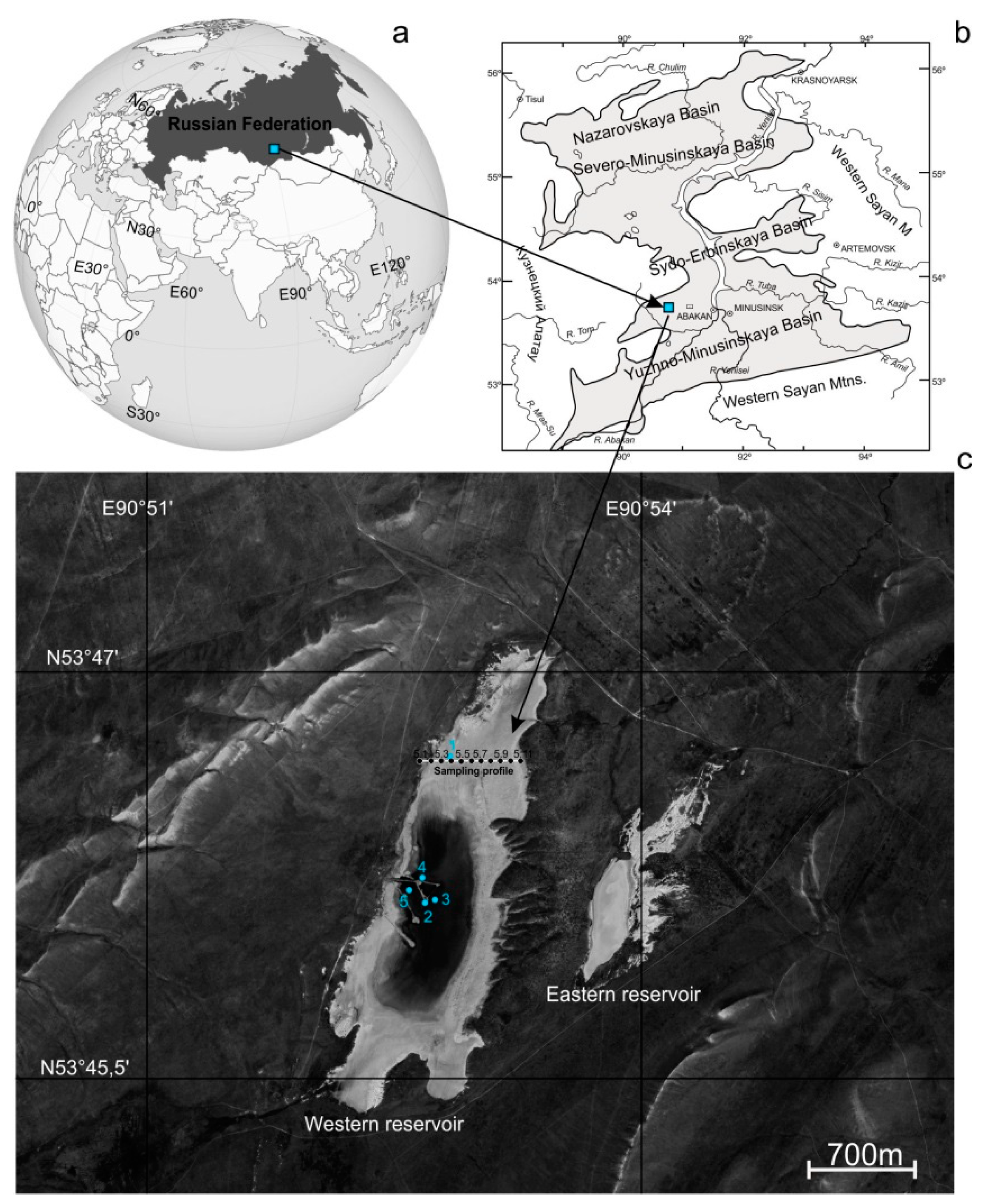
2. Characteristics of the Area and Object of Research
3. Materials and Methods
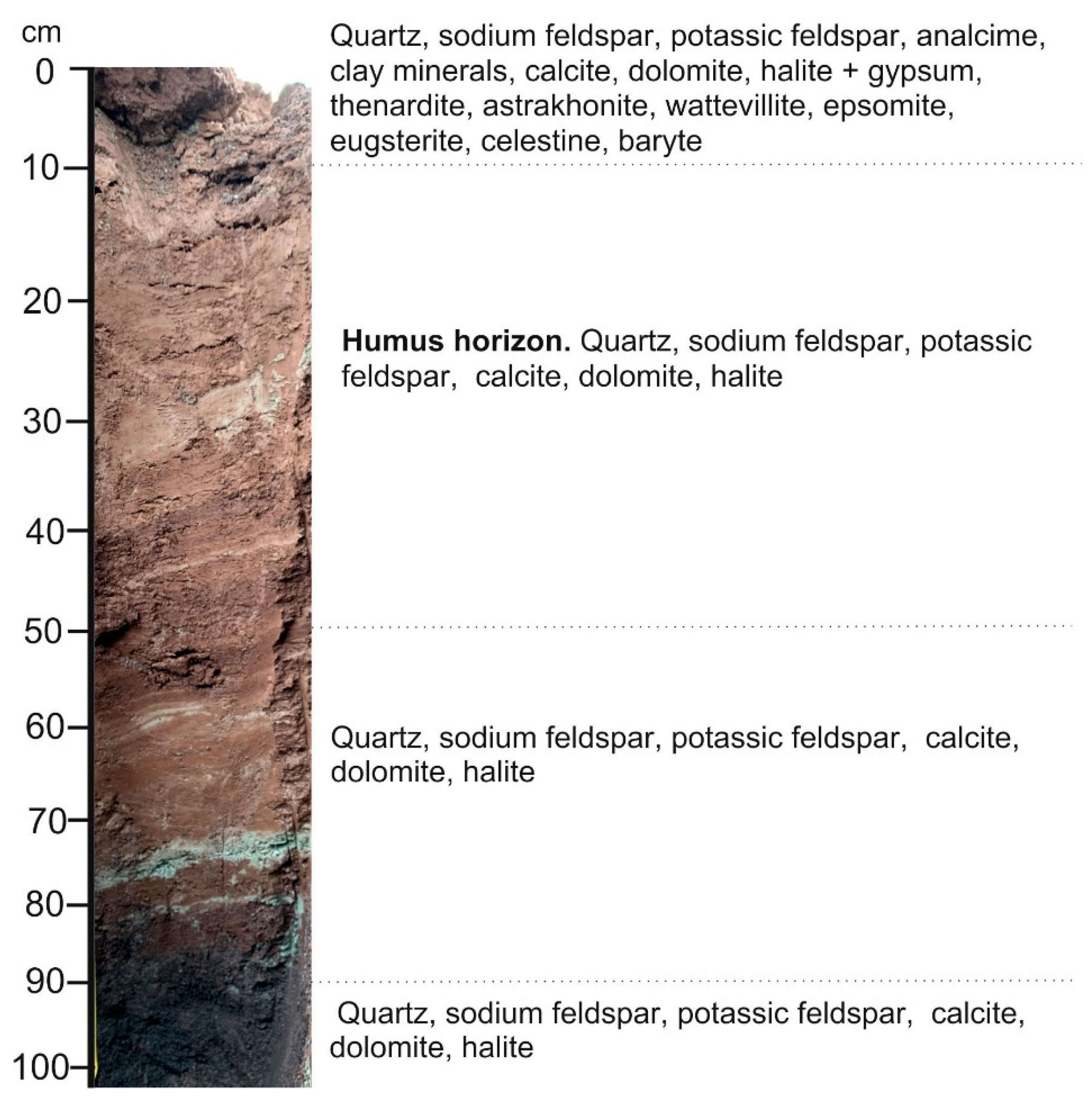
3.1. Sampling
3.2. Determination of the Chemical Composition of Solid Sediments and Water
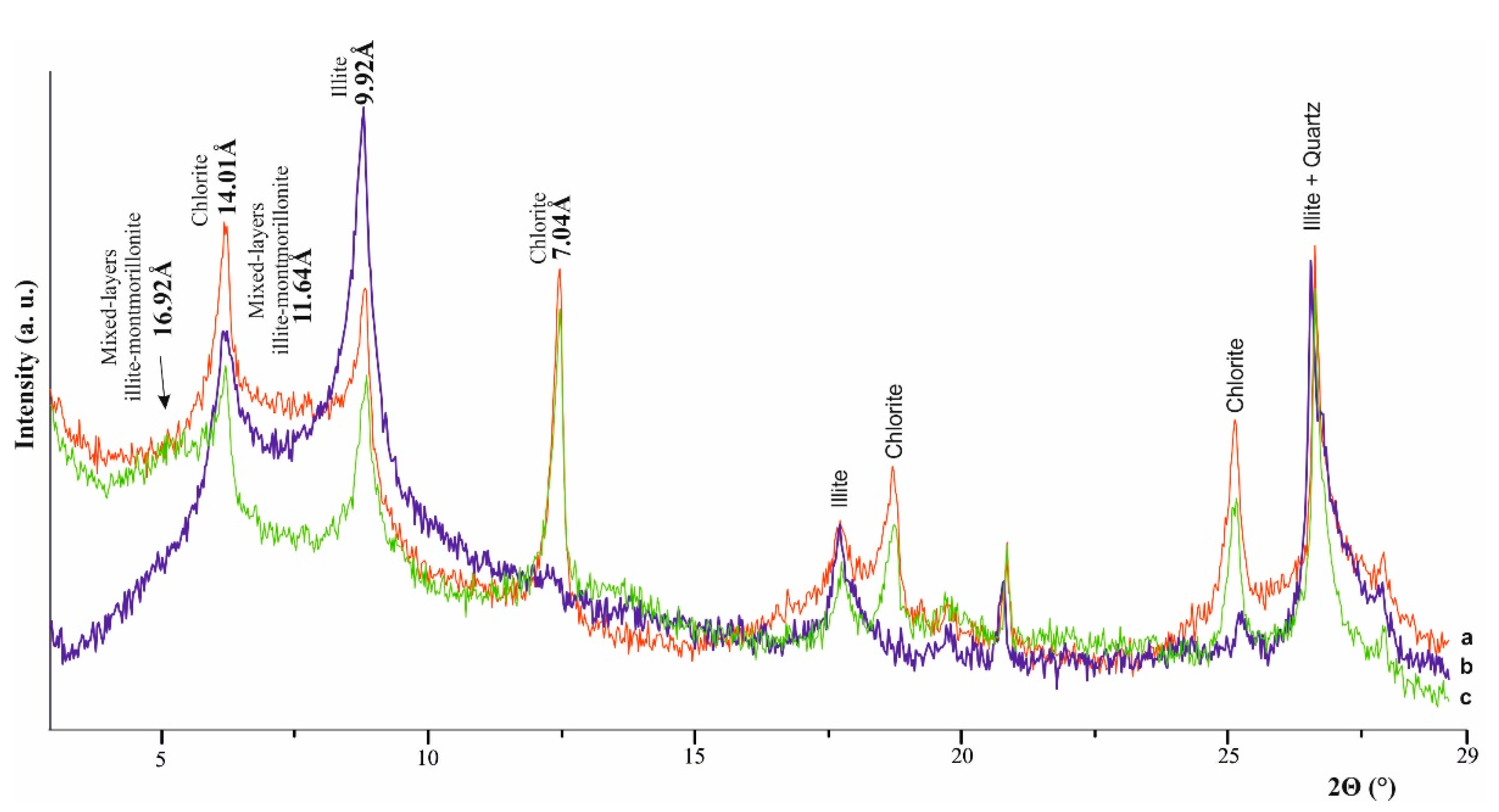
3.3. Total Mineral Composition
3.4. Physical and Chemical Calculations
4. Results and Discussion
4.1. Mineralogy of Lake Sediments
4.1.1. Oxides, Sulfides, and Aluminosilicates
4.1.2. Carbonates
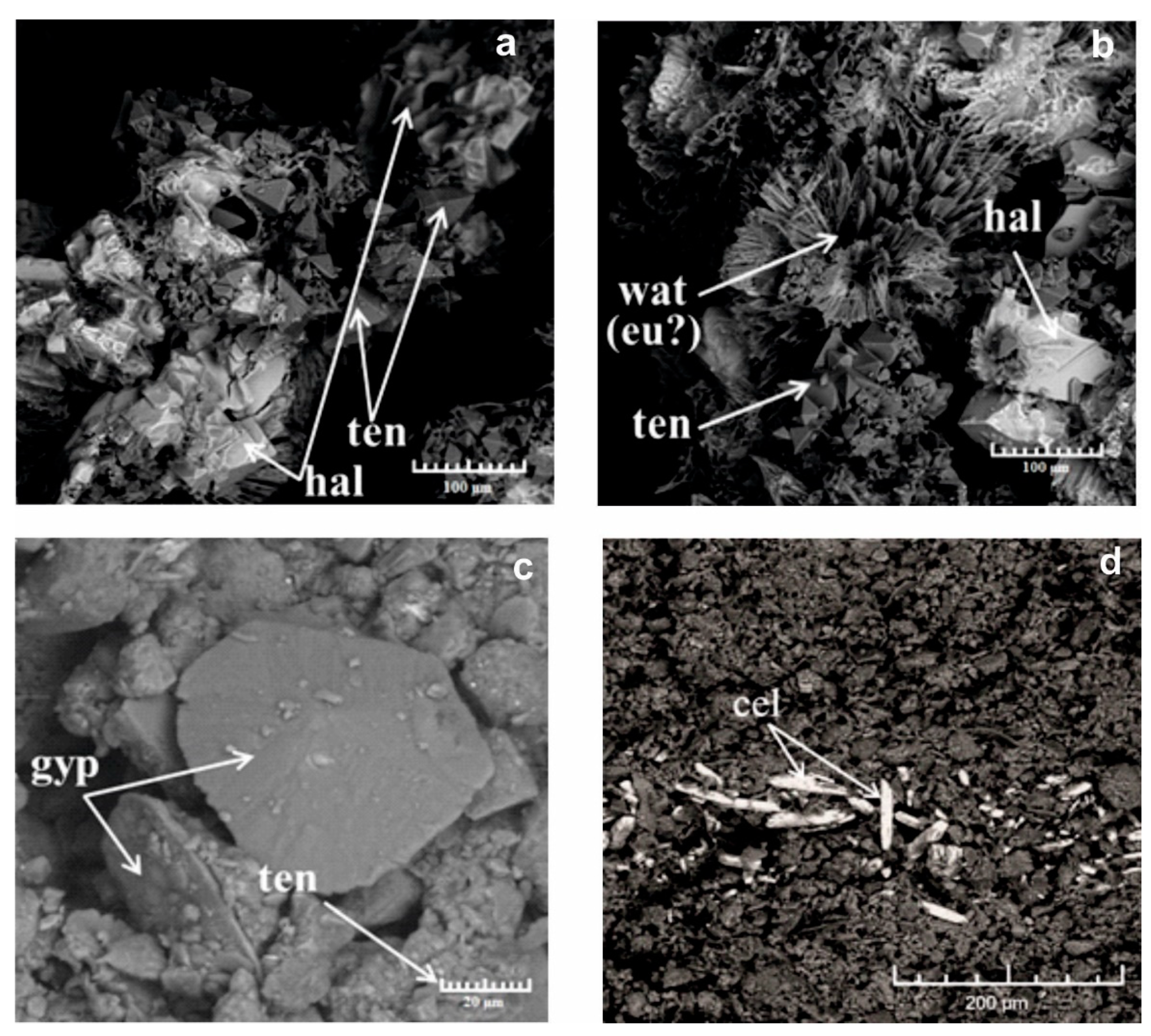
4.1.3. Sulfates
4.1.4. Haloids
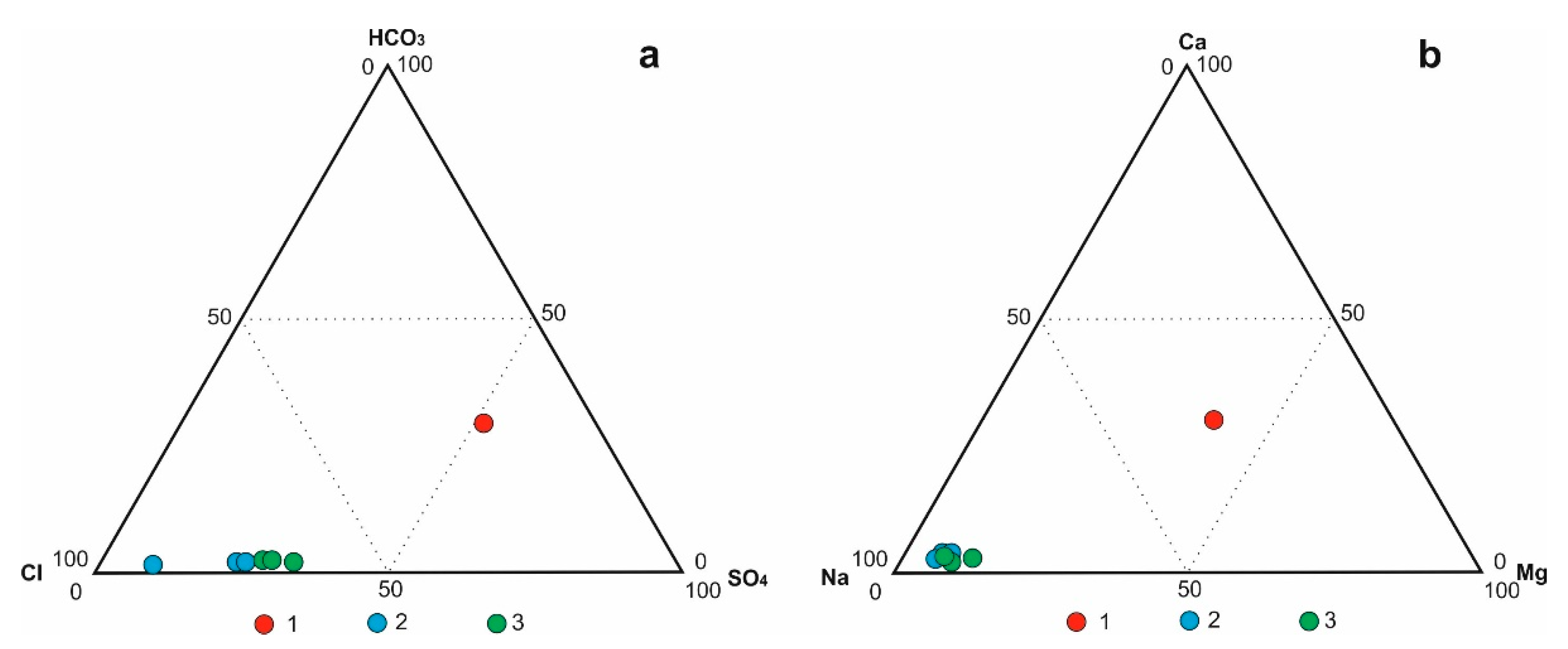
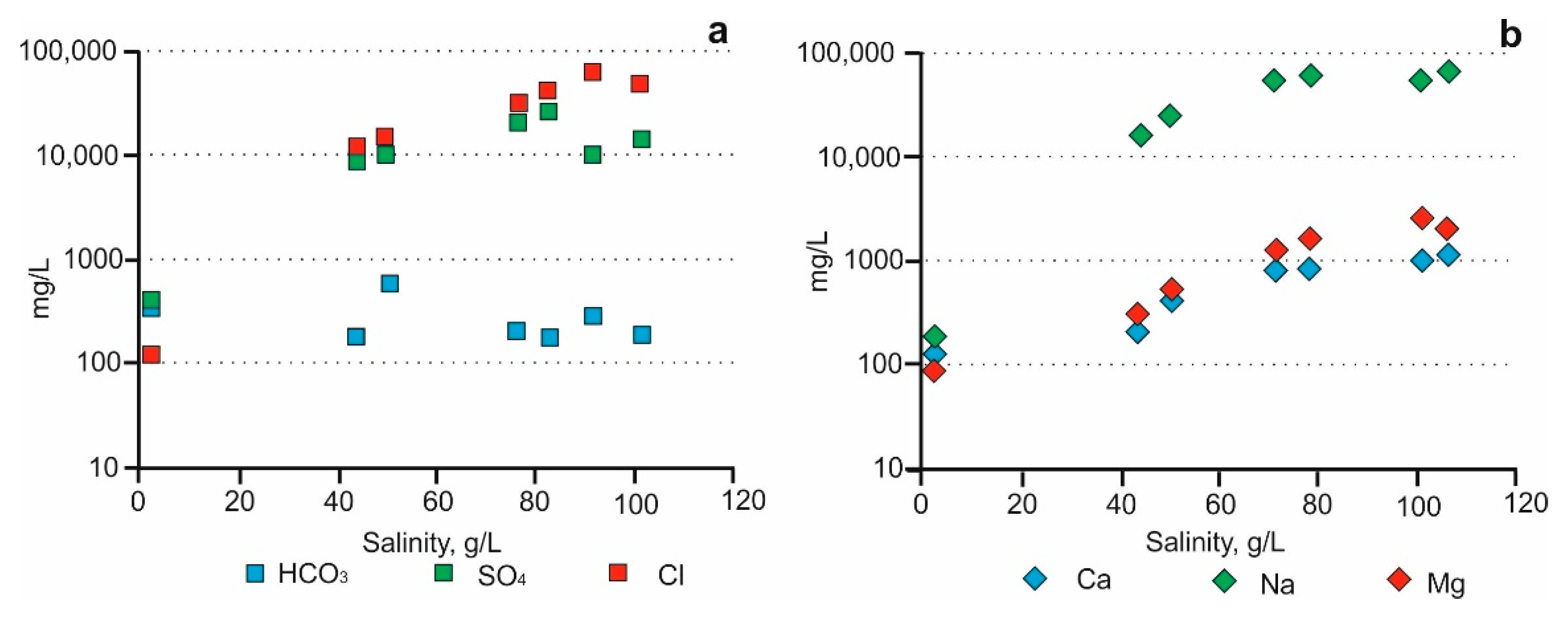
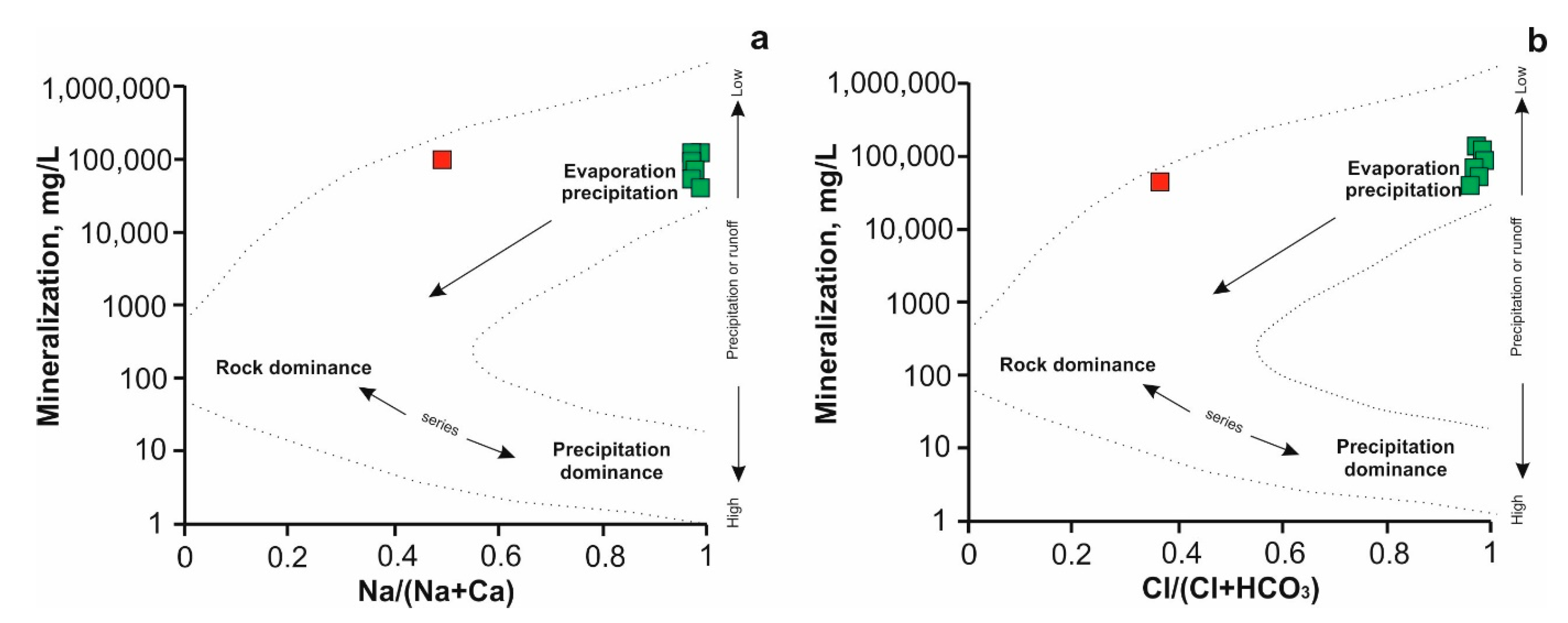
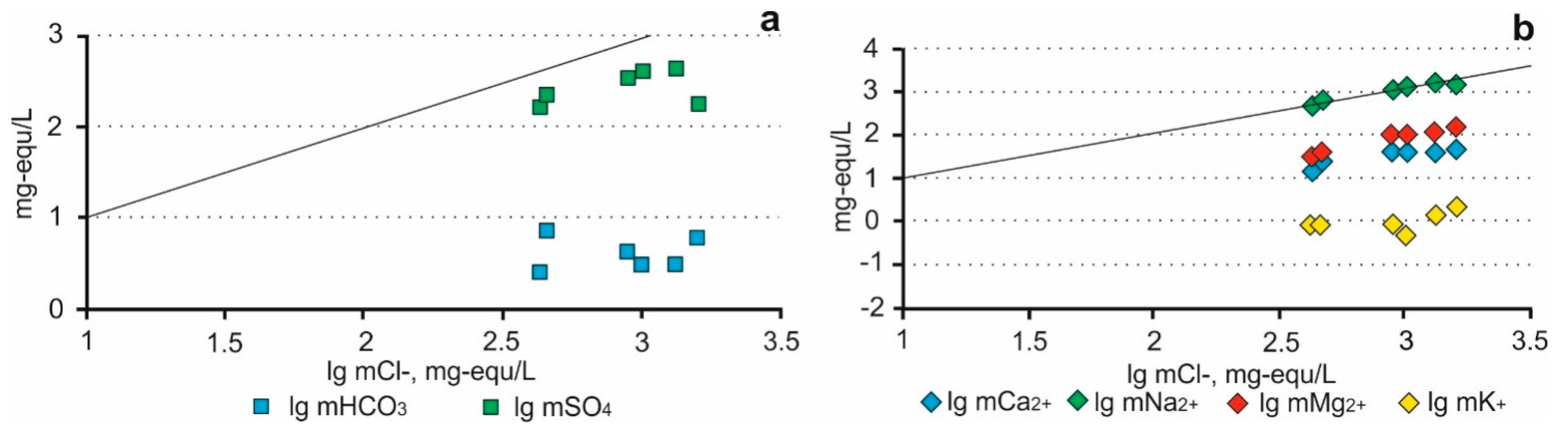
4.2. Geochemical Features and Mineral-Forming Capacity of Underground and Lake Waters
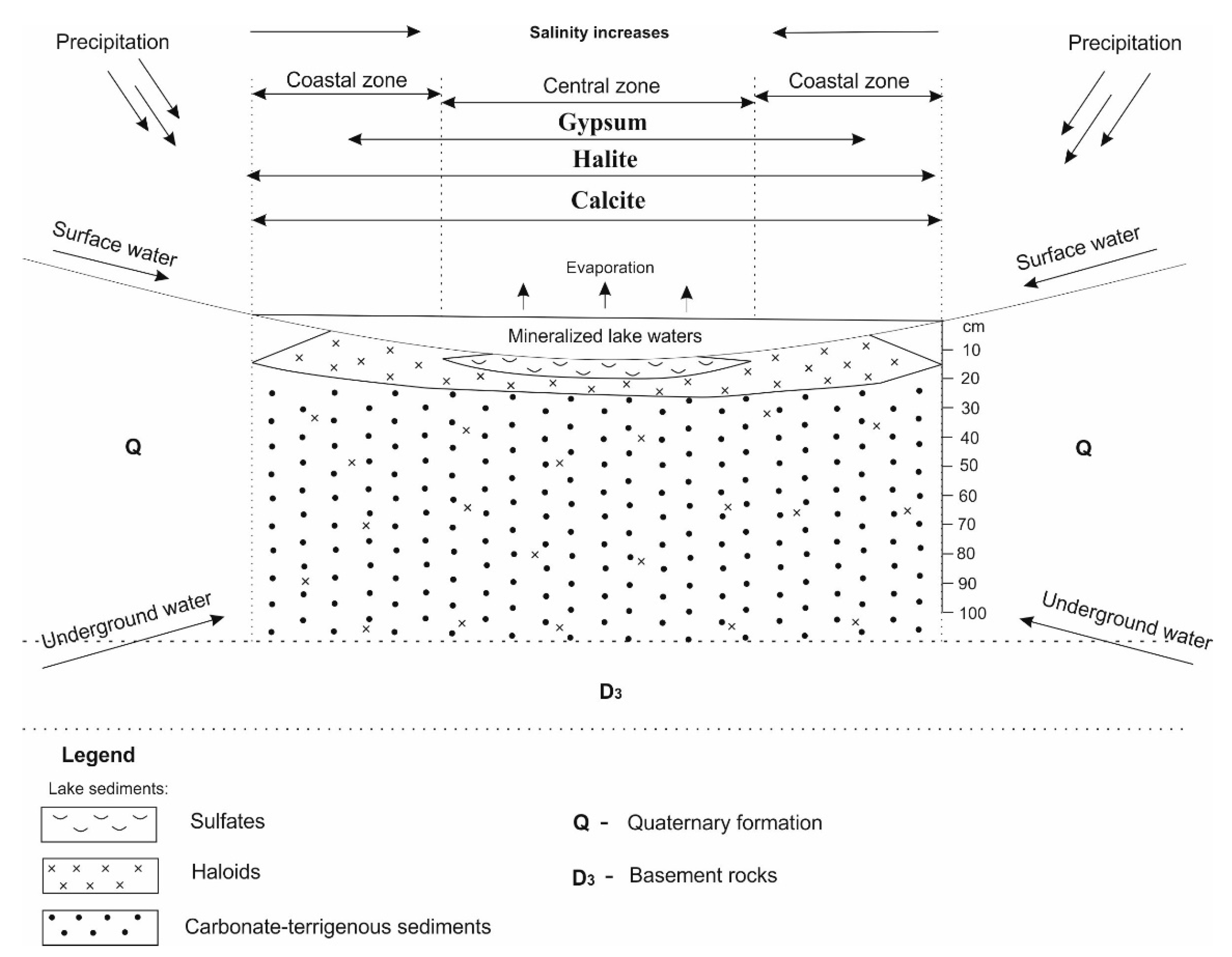
4.3. Mineral Associations and Patterns of Mineral Accumulation
5. Conclusions
Author Contributions
Funding
Data Availability Statement
Acknowledgments
Conflicts of Interest
References
- Attia, O.E. Sedimentological characteristics and geochemical evolution of Nabq sabkha, Gulf of Aqaba, Sinai, Egypt. Arab. J. Geosci. 2013, 6, 2045–2059. [Google Scholar] [CrossRef]
- Bazarova, V.B.; Grebennikova, T.A.; Mokhova, L.M.; Orlova, L.A. Holocene lake sedimentation in the steppe zone of southeastern Transbaikalia (exemplified by the Lake Zun-Soktui). Geol. Geophys. 2011, 52, 426–438. (In Russian) [Google Scholar] [CrossRef]
- Borzenko, S.V. Principal Parameters Controlling Water Composition in Saline and Brackish Lakes in Eastern Transbaikalia. Geochem. Int. 2020, 58, 1356–1373. [Google Scholar] [CrossRef]
- Kolpakova, M.; Gaskova, O.; Borzenko, S. Surface and groudwaters impact on geocemical stability of Saline lakes in semi-arid landscapes (Kulunda lowland, south of western Siberia, Russia). SGEM 2020, 3.1, 321–327. [Google Scholar]
- Kolpakova, M.N.; Gaskova, O.L.; Naymushina, O.S.; Karpov, A.V.; Vladimirov, A.G.; Krivonogov, S.K. Saline lakes of Northern Kazakhstan: Geochemical correlations of elements and controls on their accumulation in water and bottom sediments. Appl. Geochem. 2019, 107, 8–18. [Google Scholar] [CrossRef]
- Kurnakov, N.S.; Kuznetsov, V.G.; Dzens-Litovskiy, A.I.; Ravich, M.I. Salt Lakes of Crimea; Russian Academy of Sciences: Moscow, Russia, 1936. (In Russian) [Google Scholar]
- Onalgil, N.; Kadir, S.; Külaha, T.; Eren, M.; Gürel, A. Mineralogy, geochemistry and genesis of the modern sediments of Seyfe Lake, Kırşehir, central Anatolia, Turkey. Afr. Earth Sci. 2015, 102, 116–130. [Google Scholar] [CrossRef]
- Richoz, S.; Baldermann, A.; Frauwallner, A.; Harzhauser, M.; Daxner-Höck, G.; Klammer, D.; Piller, W.E. Geochemistry and mineralogy of the Oligo-Miocene sediments of the valley of lakes, Mongolia. Paleobiodivers. Paleoenviron. 2017, 97, 233–258. [Google Scholar] [CrossRef] [PubMed] [Green Version]
- Strakhovenko, V.; Subetto, D.; Ovdina, E.; Danilenko, I.; Belkina, N.; Efremenko, N.; Maslov, A. Mineralogical and geochemical composition of Late Holocene bottom sediments of Lake Onego. J. Great Lakes Res. 2020, 46, 443–455. [Google Scholar] [CrossRef]
- Parnachev, V.P.; Banks, D.; Berezovsky, A.Y.; Garbe-Schonberg, D. Hydrochemical evolution of Na-SO4-Cl groundwaters in cold, semi-arid region of southern Siberia. Hydrogeol. J. 1999, 7, 549–560. [Google Scholar] [CrossRef]
- Zamana, L.V.; Borzenko, S.V. Hydrochemical Regime of Salt Lakes of South-Eastern Transbaikalia. Geogr. Nat. Resour. 2010, 4, 100–107. [Google Scholar]
- Valyashko, M.G. Geochemical Patterns of the Formation of Deposits of Potassium Salts; Publishing House of Moscow State University: Moscow, Russia, 1962; p. 398. (In Russian) [Google Scholar]
- Warren, J. Evaporates: Sediment, Resources and Hydrocarbon; Springer: Berlin/Heidelberg, Germany, 2006; p. 1035. [Google Scholar]
- Abdi, L.; Rahimpour-Bonab, H.; Mirmohammad-Makki, M.; Probst, J.; Langeroudi, S.R. Sedimentology, mineralogy, and geochemistry of the Late Quaternary Meyghan Playa sediments, NE Arak, Iran: Palaeoclimate implications. Arab. J. Geosci. 2018, 11, 589. [Google Scholar] [CrossRef]
- Luo, C.; Peng, Z.; Yang, D.; Liu, W.; Zhang, Z.; He, J.; Chou, C. A lacustrine record from Lop Nur, Xinjiang, China: Implications for palaeoclimate change during Late Pleistocene. Asian Earth Sci. 2009, 34, 38–45. [Google Scholar]
- Roop, H.A.; Dunbar, G.B.; Levy, R.; Vandergoes, M.J.; Forrest, A.L.; Walker, S.L.; Purdie, J.; Upton, P.; Whinney, J. Seasonal controls on sediment transport and deposition in Lake Ohau, South Island, New Zealand: Implications for a high-resolution Holocene paleoclimate reconstruction. Sedimentology 2015, 62, 826–844. [Google Scholar] [CrossRef]
- Sinha, R.; Raymahashay, B.C. Evaporite mineralogy and geochemical evolution of the Sambhar Salt Lake, Rajestan, India. Sediment. Geol. 2004, 166, 59–71. [Google Scholar] [CrossRef]
- Sklyarov, E.V.; Solotcina, E.P.; Vologina, E.G.; Ignatova, N.V.; Izokh, O.P.; Kulagina, N.V.; Sklyarova, O.A.; Solotchin, P.A.; Stolpovskaya, V.N.; Ukhova, N.N.; et al. Detailed holocene climate record from the carbonate section of saline lake Tsagan-Tyrm (West Baikal area). Geol. Geophys. 2010, 51, 303–328. (In Russian) [Google Scholar] [CrossRef]
- Yang, Y.; Fang, X.; Koutsodendrisc, A.; Yea, C.; Yanga, R.; Zhang, W.; Liua, X.; Gaoa, S. Exploring Quaternary paleolake evolution and climate change in the western Qaidam Basin based on the bulk carbonate geochemistry of Lake sediments. Palaeogeogr. Palaeoclimatol. Palaeoecol. 2016, 446, 152–161. [Google Scholar] [CrossRef]
- Charykova, M.V.; Charykov, N.A. Thermodynamic Modeling of Evaporite Sedimentation Processes; Nauka: St. Petersburg, Russia, 2003; p. 261. (In Russian) [Google Scholar]
- Solotchina, E.P.; Sklyarov, E.V.; Solotchin, P.A.; Vologina, E.G.; Stolpovskaya, V.N.; Sklyarova, O.A.; Ukhova, N.N. Reconstruction of the Holocene climate based on a carbonate sedimentary record from shallow saline Lake VerkhneeBeloe (western Transbaikalia). Russ. Geol. Geophys. 2012, 53, 1351–1365. (In Russian) [Google Scholar] [CrossRef]
- Banks, D.; Parnachev, V.P.; Frengstad, B.; Holden, W.; Karnachuk, O.V.; Vedernikov, A.A. The Hydrogeochemistry of the Altaiskii, Askizskii, Beiskii, Bogradskii, Shirinskii, Tashtipskii and Ust’ Abakanskii Regions, Republic of Khakassia, Southern Siberia, Russian Federation; Norges Geologiske Undersøkelse (NGU): Trondheim, Norway, 2001; ISSN 0800-3416. [Google Scholar]
- Banks, D.; Parnachev, V.P.; Frengstad, B.; Holden, W.; Karnachuk, O.V.; Vedernikov, A.A. The evolution of alkaline, saline ground- and surface waters in the southern Siberian steppes. Appl. Geochem. 2004, 19, 1905–1926. [Google Scholar] [CrossRef]
- Banks, D.; Parnachev, V.P.; Frengstad, B.; Karnachuk, O.V. Hydrogeochemical Data Report: The Sampling of Selected Locations in the Republic of Khakassia, Kuznetsk Alatau Oblast’ and Kemerovo Oblast’, Southern Siberia, Russian Federation; Geological Survey of Norway: Trondheim, Norway, 2008. [Google Scholar]
- Kopylova, Y.G.; Guseva, N.V.; Khvaschevskaya, A.A.; Smetanina, I.V. Guide to the Lakes of Khakassia; Tomsk Polytechnic University: Tomsk, Russia, 2014; p. 108. [Google Scholar]
- Parnachev, V.P.; Degermendzhy, A.G. Geographical, geological and hydrochemical distribution of saline lakes in Khakasia, Southern Siberia. Aquat. Ecol. 2002, 36, 107–122. [Google Scholar] [CrossRef]
- Makarevich, A.A. Informational Report on the Results of the Work Carried out on the Selection of Technological Samples at the Taloe Lake Site; Abakan: Abakan, Russia, 1998; p. 7. [Google Scholar]
- Rogozin, D.Y. Meromictic Lakes of the North Minusinsk Depression: Patterns of Stratification and Ecology of Phototrophic Sulfur Bacteria; Publishing House: IF SB RAS: Krasnoyarsk, Russia, 2018; p. 241. (In Russian) [Google Scholar]
- Kamenov, G.D. ICP-MS and Material Analysis. In The Encyclopedia of Archaeological Sciences; López Varela, S.L., Ed.; John Wiley & Sons Inc.: Hoboken, NJ, USA, 2018. [Google Scholar] [CrossRef] [Green Version]
- Khodakov, G.S.; Yudkin, Y.P. Sedimentation Analysis of Highly Dispersed Systems; Khimiya: Moscow, Russia, 1981. (In Russian) [Google Scholar]
- Bukaty, M.B. Development of software for solving hydrogeological problems. Geol. Prospect. Explor. Miner. Resour. Sib. 2002, 305, 348–365. (In Russian) [Google Scholar]
- Bukaty, M.B. Advertising and technical description of the software package HydroGeo. In All-Russian Scientific and Technical Information Centre Registration of Algorithms and Programmes No.50200500605; All-Russian Scientific and Technical Information Centre: Moscow, Russia, 2005; p. 7. (In Russian) [Google Scholar]
- Bukaty, M.B. Numerical models of water-rock systems: Quality problems (Chapter 6.7). In Geochemical Evolution and Self-Organisation of Water Rock Systems (5 Volumes): Volume 1: Water-Rock Systems in the Earth’s Crust: Interaction, Kinetics, Equilibrium, Modelling; Shvartsev, S.L., Ed.; SORAN: Novosibirsk, Russia, 2005; pp. 243–332. (In Russian) [Google Scholar]
- Allison, J.D.; Brown, D.S.; Novo-Gradac, K.J. MINTEQA2/PRODEFA2, Geochemical Assessment Model for Environmental Systems: Version 3.0 User’s Manual; United States Environmental Protection Agency report EPA/600/3-91/021; United States Environmental Protection Agency: Athens, GA, USA, 1991; p. 107. [Google Scholar]
- Parkhurst, D.L.; Appelo, C.A.J. User’s Guide to PHREEQC (Version 2) Computer Program for Speciation, Batch-Reaction, One-Dimensional Transport, and Inverse Geochemical Calculations; U.S. Geological Survey Water Resources Investigations Report 99-4259; U.S. Geological Survey: Reston, VA, USA, 1999; p. 310. [Google Scholar]
- Berman, R.G. Internally-consistent thermodynamic data for minerals in the system Na2O-K2O-CaO-MgO-FeO-Fe2O3-Al2O3-SiO2-TiO2-H2O-CO2. Petrology 1998, 29, 445–522. [Google Scholar] [CrossRef]
- Cleverley, J.S.; Bastrakov, E.N. K2GWB: Utility for generating thermodynamic data files for the Geochemist’s Workbench at 0-1000 C and 1-5000 bar from UT2K and the UNITHERM database. Comput. Geosci. 2005, 31, 756–767. [Google Scholar] [CrossRef]
- Shvarov, Y.V.; Bastrakov, E.N. HCh: A Software Package for Geochemical Equilibrium Modelling (User’s Guide); Australian Geological Survey Organization: Canberra, Australia, 1999; p. 61. [Google Scholar]
- Harvie, C.E.; Moller, N.; Weare, J.H. The prediction of mineral solubilities in natural waters: The Na-K-Mg-Ca-H-Cl-SO4-OH-HCO3-CO3-CO2-H2O system to high ionic strength at 25 C. Geochim. Cosmochim. Acta 1984, 48, 723–751. [Google Scholar] [CrossRef]
- Balobanenko, A.A.; L’gotin, V.; Dutova, E.M.; Pokrovsky, D.S.; Nikitenkov, A.N.; Raduk, I.V. Geochemical groundwater peculiarities of Paleogene sediments in S-E Western Siberia artesian basin. IOP Conf. Ser. Earth Environ. Sci. 2016, 43, 012030. [Google Scholar] [CrossRef]
- Dutova, E.M. Geochemistry of fresh groundwater in the Altai-Sayan folded area and adjacent areas of the West Siberian plate. Appl. Geochem. 2020, 120, 104673. [Google Scholar] [CrossRef]
- Dutova, E.M.; Bukaty, M.B.; Nevol’ko, A.I.; Pokrovsky, D.S.; Shvartsev, S.L. Hydrogenic concentration of gold in alluvial placers of the Egor’evsk area (Salair). Geol. Geofiz. 2006, 47, 364–376. (In Russian) [Google Scholar]
- Dutova, E.; Nikitenkov, A.; Kuzevanov, K. The HydroGeo Software Package and Its Usage. E3S Web Conf. 2019, 98, 04005. [Google Scholar] [CrossRef]
- Dutova, E.M.; Nikitenkov, A.N.; Pokrovskiy, V.D.; Banks, D.; Frengstad, B.S.; Parnachev, V.P. Modelling of the dissolution and reprecipitation of uranium under oxidizing conditions in the zone of shallow groundwater circulation. Environ. Radioact. 2017, 178–179, 63–76. [Google Scholar] [CrossRef] [PubMed] [Green Version]
- Gaskova, O.L.; Shironosova, G.P.; Kabannik, V.G.; Bukaty, M.B. Thermodynamic model for sorption of bivalent heavy metals on calcite in natural-technogenic environments. Russ. Geol. Geophys. 2009, 50, 87–95. (In Russian) [Google Scholar] [CrossRef]
- Shvartsev, S.L.; Dutova, E.M. Hydrochemistry and mobilization of gold in the hypergenesis zone (Kuznetsk Alatau, Russia). Geol. Ore Depos. 2001, 43, 224–233. [Google Scholar]
- Dutova, E.; Vologdina, I.; Pokrovsky, D.; Nalivaiko, N.; Kuzevanov, K.; Pokrovsky, V. Hydrogenous mineral neoformations in Tomsk water intake facility from underground sources. IOP Conf. Ser. Earth Environ. Sci. 2016, 33, 012017. [Google Scholar] [CrossRef] [Green Version]
- Karmalov, A.I.; Dutova, E.M.; Vologdina, I.V.; Pokrovsky, D.S.; Pokrovskiy, V.D.; Kuzevanov, K.K. Hydrogeochemical Characteristics of Water Intakes from Groundwater Sources in Seversk. IOP Conf. Ser. Earth Environ. Sci. 2016, 43, 012032. [Google Scholar] [CrossRef] [Green Version]
- Vologdina, I.V.; Dutova, E.M.; Pokrovsky, D.S.; Pokrovsky, V.D.; Radyuk, I.V. Natural and technogenic mineral new growths at water intakes in Tomsk region. Bull. St. Petersburg Univ. Ser. 7 Geol. Geogr. 2015, 3, 58–72. (In Russian) [Google Scholar]
- Larsen, D. Revisiting silicate authigenesis in the Pliocene-Pleistocene Lake Tecopa beds, southeastern California: Depositional and hydrological controls. Geosphere 2008, 4, 612–639. [Google Scholar] [CrossRef] [Green Version]
- Borzenko, S.V. The main conditions for the formation of the chemical composition of the waters of saline and brackish lakes in Eastern Transbaikalia. Geochemistry 2020, 65, 1212–1230. (In Russian) [Google Scholar]
- Bailey, S.W.; Brindley, G.W.; Fanning, D.S.; Kodama, H.; Martin, R.T. Report of the Clay Minerals Society Nomenclature Committee for 1982 and 1983. Clay Clay Miner. 1984, 32, 239–240. [Google Scholar] [CrossRef]
- Khrushcheva, M.O.; Nebera, T.S. Swelling clay minerals of bottom sediments of Uskol lake (Republic of Khakassia). IOP Conf. Ser. Earth Environ. Sci. 2019, 319, 012010. [Google Scholar] [CrossRef] [Green Version]
- Gibbs, R.J. Mechanisms controlling world water chemistry. Science 1970, 170, 1088–1090. [Google Scholar] [CrossRef] [PubMed]
- Drever, I.D. The Geochemistry of Natural Waters; Prentice-Hall: Upper Saddle River, NJ, USA, 1988; p. 440. [Google Scholar]
- Eugster, H.P.; Hardie, L.A. Saline Lakes. In Geology and Physics; Springer: Berlin/Heidelberg, Germany, 1978; pp. 237–293. [Google Scholar]


| Group of Minerals | Mineral | Chemical Formula of the Mineral | Coastal Zone | Central Zone | ||||
|---|---|---|---|---|---|---|---|---|
| Avg | Min | Max | Avg | Min | Max | |||
| Oxides | Quartz | SiO2 | 30 | 25 | 35 | 28 | 22 | 37 |
| Hematite | Fe2O3 | <1 | <1 | <1 | <1 | <1 | <1 | |
| Sulfides | Pyrite | FeS2 | <1 | <1 | <1 | <1 | <1 | <1 |
| Aluminosilicates | Chlorite group | (Mg, Fe, Al, Cr, Ni, Mn)3(Si, Al)4 O10(OH)2 × (Mg, Fe, Mn)3(OH)6 | 17 | 12 | 22 | 15 | 6 | |
| Illite | (K0.75(H3O)0.25)Al2(Si3Al)O10((H2O)0.75(OH)0.25)2 | 14 | 10 | 19 | 16 | 9 | 32 | |
| MLF 1 | - | 5 | 2 | 9 | 4 | 2 | 7 | |
| Albite | Na[AlSi3O8] | 10 | 6 | 15 | 10 | 5 | 15 | |
| Potassic feldspar | K[AlSi3O8] | 2 | 0 | 3 | 2 | 0 | 7 | |
| analcime | Na[AlSi2O6] × H2O | 1 | 0 | 2 | 2 | 0 | 4 | |
| Carbonates | Calcite | CaCO3 | 17 | 10 | 25 | 19 | 10 | 29 |
| Dolomite | CaMg(CO3)2 | 2 | 0 | 4 | 2 | 0 | 5 | |
| Aragonite | CaCO3 | <1 | <1 | <1 | <1 | <1 | <1 | |
| Sulfates | Gypsum | CaSO4 | n.f. | n.f. | n.f. | 6 | 0 | 13 |
| Thénardite | Na2SO4 | n.f. | n.f. | n.f. | <1 | 0 | <1 | |
| Blödite | Na2Mg(SO4)2 × 4H2O | n.f. | n.f. | n.f. | <1 | 0 | <1 | |
| Wattevillite | Na2Ca(SO4)2 × 4H2O | n.f. | n.f. | n.f. | <1 | 0 | <1 | |
| Epsomite | MgSO4 × 7H2O | n.f. | n.f. | n.f. | <1 | 0 | <1 | |
| Eugsterite | Na4Ca(SO4)3 × 2H2O | n.f. | n.f. | n.f. | <1 | 0 | <1 | |
| Celestine | SrSO4 | n.f. | n.f. | n.f.. | <1 | 0 | <1 | |
| Baryte | BaSO4 | n.f.. | n.f. | n.f. | <1 | 0 | <1 | |
| Haloids | Halite | NaCl | 5 | 0 | 11 | 5 | 0 | 14 |
| Chemical Composition / Sample | Underground Waters | Water Type | |||||
|---|---|---|---|---|---|---|---|
| Surface Waters | Pore Waters of Lake Sediments | ||||||
| Ха-60 | 1 | 2 | 3 | 4 | 5 | 6 | |
| pH | 7.27 | 7.58 | 7.37 | 7.27 | 7.60 | 7.47 | 7.41 |
| HCO3− | 339 | 244 | 153 | 427 | 183 | 183 | 360 |
| SO42− | 456 | 16,230 | 7882 | 10,502 | 19,060 | 20,784 | 8372 |
| Cl− | 124 | 31,510 | 15,227 | 16,150 | 35,460 | 46,735 | 56,325 |
| Mineralization | 1394 | 75,216 | 36,661 | 42,309 | 86,557 | 10,6916 | 100,293 |
| Ca2+ | 120 | 900 | 300 | 460 | 810 | 800 | 963 |
| Mg2+ | 92 | 1190 | 378 | 482 | 1202 | 1306 | 1990 |
| Na+ | 143 | 25,009 | 12,650 | 14,214 | 29,204 | 36,937 | 31,700 |
| K+ | 2.3 | 31.4 | 31.2 | 33.2 | 18.0 | 53.0 | 83.2 |
| Br | 0.98 | 92.25 | 38.73 | 40.96 | 97.98 | 118.00 | 200.00 |
| Li | 0.03 | 1.72 | 0.33 | 0.78 | 1.84 | 2.28 | 5.38 |
| Sr | 2.88 | 33.53 | 9.18 | 7.97 | 31.26 | 34.22 | 21.4 |
| B | 0.17 | 8.34 | 13.96 | 3.56 | 8.99 | 11.18 | 1.58 |
| Mineral | Chemical Formula of The Mineral | Water Type | ||||||
|---|---|---|---|---|---|---|---|---|
| UnderGround Waters | Surface Waters | Pore Waters of Lake Sediments | ||||||
| Ха-60 | 1 | 2 | 3 | 4 | 5 | 6 | ||
| Hydroxides | ||||||||
| Goethite | FeOOH | 3.00 | −0.06 | −0.41 | −1.60 | 0.18 | 0.16 | −0.36 |
| Lepidocrocite | FeOOH | −2.10 | −5.1 | −5.4 | −6.6 | −4.9 | −4.9 | −5.4 |
| Bayerite | Al(OH)3 | 6.50 | 5.10 | 6.50 | 5.20 | 4.90 | 5.40 | 5.10 |
| Gibbsite | Al(OH)3 | 3.90 | 2.40 | 3.80 | 2.60 | 2.30 | 2.70 | 2.50 |
| Oxides | ||||||||
| Hematite | Fe2O3 | 11.00 | 4.60 | 3.90 | 1.50 | 5.10 | 5.10 | 4.00 |
| Quartz | SiO2 | 1.40 | 0.05 | −0.01 | 0.49 | 0.14 | 0.06 | 0.14 |
| Quartz (cryptocrystalline variety) | SiO2 | 0.70 | −0.61 | −0.67 | −0.17 | −0.52 | −0.60 | −0.52 |
| Cristobalite | SiO2 | 0.01 | −1.30 | −1.40 | −0.86 | −1.20 | −1.30 | −1.20 |
| Tridymite | SiO2 | 0.40 | −0.90 | −0.97 | −0.47 | −0.82 | −0.89 | −0.81 |
| Silicates and aluminosilicates | ||||||||
| Nontronite | Na0.3Fe2(Si, Al)4O10(OH) × nH2O | 22.00 | 14.00 | 17.00 | 15.00 | 14.00 | 14.00 | 14.00 |
| Montmorillonite group | Fe0.2924Mg2.9Al1.6984Si3.935O10(OH)2 | 9.20 | 0.78 | 2.50 | 1.90 | 0.90 | 1.30 | 1.20 |
| Al2Si4O10(OH)2 | 22.00 | 14.00 | 17.00 | 16.00 | 14.00 | 15.00 | 15.00 | |
| Ca0.187Na0.0205K0.0205Fe0.141Mg0.336Al1.59Si3.93O10(OH)2 | 18.00 | 10.00 | 11.00 | 11.00 | 10.00 | 11.00 | 11.00 | |
| K0.3Al1.9Si4O10(OH)2 | 15.00 | 8.00 | 10.00 | 9.80 | 7.90 | 8.60 | 8.60 | |
| Mg0.6525Fe0.335Al1.47Si3.82O10(OH)2 | 18.00 | 10.00 | 11.00 | 10.00 | 11.00 | 11.00 | 11.00 | |
| Na0.27Ca0.1K0.02Fe0.19Mg0.22Al1.58Si3.94O10(OH)2 | 18.00 | 11.00 | 12.00 | 12.00 | 11.00 | 12.00 | 12.00 | |
| Ca0.15Al1.9Si4O10(OH)2 | 23.00 | 16.00 | 18.00 | 17.00 | 16.00 | 16.00 | 16.00 | |
| Beidellite | Mg0.165Al2.33Si3.67O10(OH)2 | 22.00 | 14.00 | 17.00 | 16.00 | 14.00 | 15.00 | 15.00 |
| Ca0.165Al2.33Si3.67O10(OH)2 | 22.00 | 14.00 | 17.00 | 16.00 | 14.00 | 15.00 | 15.00 | |
| Na0.33Al2.33Si3.67O10(OH)2 | 24.00 | 17.00 | 20.00 | 19.00 | 18.00 | 18.00 | 18.00 | |
| Chlorite group | Mg6Si4O10(OH)8 | −26.00 | −30.0 | −40.0 | −41.00 | −30.0 | −34.0 | −30.0 |
| Illite | K0.63Na0.017Ca0.145Fe0.327Mg0.349Al1.9Si3.421O10(OH)2 | 22.00 | 15.00 | 16.00 | 15.00 | 15.00 | 16.00 | 16.00 |
| K-Mg-illite | K0.6Mg0.25Al2.3Si3.5O10(OH)2 | 25.00 | 18.00 | 21.00 | 19.00 | 18.00 | 19.00 | 19.00 |
| Illite | K0.5Al2.5Si3.5O10(OH)2 | 27.00 | 20.00 | 23.00 | 21.00 | 20.00 | 21.00 | 21.00 |
| Anorthite | CaAl2Si2O8 | −2.70 | −7.30 | −6.60 | −8.20 | −7.50 | −7.30 | −7.40 |
| Albite | NaAlSi3O8 | −0.58 | −0.04 | −0.18 | −0.14 | 0.21 | 0.56 | −3.77 |
| Potassic feldspar | KAlSi3O8 | 0.15 | −0.52 | −0.34 | −0.31 | −0.59 | 0.09 | −3.98 |
| Carbonate | ||||||||
| Magnesite | MgCO3 | −0.65 | −1.30 | −2.70 | −2.00 | −1.80 | −2.10 | −0.80 |
| Lansfordite | MgCO3 × 5H2O | −2.80 | −3.70 | −5.00 | −4.30 | −4.20 | −4.60 | −3.40 |
| Witherite | BaCO3 | −8.30 | −10.0 | −10.0 | −11.0 | −11.0 | −12.0 | −12.0 |
| Aragonite | CaCO3 | 2.50 | 2.20 | 0.57 | 1.70 | 1.80 | 1.50 | 2.30 |
| Calcite | CaCO3 | 2.80 | 2.60 | 0.92 | 2.00 | 2.20 | 1.80 | 2.60 |
| Dolomite | CaMg(CO3)2 | 3.90 | 3.00 | −0.10 | 1.70 | 2.10 | 1.40 | 3.60 |
| Siderite | FeCO3 | −3.00 | −7.60 | −7.10 | −6.80 | −7.80 | −7.30 | −6.90 |
| Rhodochrosite | MnCO3 | −2.40 | −5.20 | −5.60 | −1.20 | −6.20 | −7.00 | −1.90 |
| Strontianite | SrCO3 | 0.38 | −0.30 | −1.80 | −1.40 | −0.80 | −1.10 | −0.71 |
| Sulfates | ||||||||
| Epsomite | MgSO4 × 7H2O | −7.20 | −5.80 | −6.20 | −6.20 | −6.00 | −6.10 | −6.20 |
| Kieserite | MgSO4 × H2O | −64.00 | −63.00 | −63.00 | −63.00 | −63.00 | −63.00 | −63.00 |
| Thénardite | Na2SO4 | −61.00 | −50.00 | −52.00 | −51.00 | −50.00 | −50.00 | −50.00 |
| Baryte | BaSO4 | 0.14 | 0.31 | 1.40 | −0.29 | 0.05 | −0.20 | −1.40 |
| Anhydrite | CaSO4 | −3.50 | −1.40 | −2.20 | −1.70 | −1.40 | −1.50 | −1.90 |
| Gypsum | CaSO4 × 2H2О | −0.97 | 0.32 | −0.28 | 0.00 | 0.31 | 0.31 | 0.07 |
| Melanterite | FeSO4 × 7H2O | −7.80 | −10.00 | −8.80 | −9.20 | −10.00 | −9.50 | −11.0 |
| Jarosite | KFe3(SO4)2(OH)6 | −33.00 | −37.00 | −36.00 | −39.00 | −37.00 | −35.00 | −38.0 |
| Celestine | SrSO4 | 0.47 | 2.10 | 1.40 | 1.20 | 2.00 | 1.90 | 1.10 |
| Haloids | ||||||||
| Halite | NaCl | −15.00 | −4.70 | −5.90 | −5.80 | −4.40 | −3.90 | −3.70 |
| Hydrohalite | NaCl × 2H2O | −14.00 | −4.50 | −5.70 | −5.50 | −4.20 | −3.80 | −3.50 |
| Antarcticite | CaCl2 × 6H2O | −95.00 | −84.00 | −86.00 | −86.00 | −84.0 | −84.0 | −83.00 |
| Bischofite | MgCl2 × 6H2O | −100.00 | −93.00 | −95.00 | −95.00 | −93.0 | −93.0 | −91.00 |
| Sylvite | KCl | −17.00 | −10.00 | −11.00 | −10.00 | −10.0 | −9.10 | −8.40 |
| Scacchite | MnCl2 | −52.00 | −43.00 | −44.00 | −40.00 | −43.0 | −43.0 | −38.00 |
Publisher’s Note: MDPI stays neutral with regard to jurisdictional claims in published maps and institutional affiliations. |
© 2021 by the authors. Licensee MDPI, Basel, Switzerland. This article is an open access article distributed under the terms and conditions of the Creative Commons Attribution (CC BY) license (https://creativecommons.org/licenses/by/4.0/).
Share and Cite
Khrushcheva, M.O.; Dutova, E.M.; Tishin, P.A.; Arkhipov, A.L.; Nikitenkov, A.N.; Chernyshov, A.I. Taloe—Sedimentation in an Intermittent Lake (Russian Federation, Republic of Khakassia). Minerals 2021, 11, 522. https://0-doi-org.brum.beds.ac.uk/10.3390/min11050522
Khrushcheva MO, Dutova EM, Tishin PA, Arkhipov AL, Nikitenkov AN, Chernyshov AI. Taloe—Sedimentation in an Intermittent Lake (Russian Federation, Republic of Khakassia). Minerals. 2021; 11(5):522. https://0-doi-org.brum.beds.ac.uk/10.3390/min11050522
Chicago/Turabian StyleKhrushcheva, Maria O., Ekaterina M. Dutova, Platon A. Tishin, Alexander L. Arkhipov, Alexei N. Nikitenkov, and Alexei I. Chernyshov. 2021. "Taloe—Sedimentation in an Intermittent Lake (Russian Federation, Republic of Khakassia)" Minerals 11, no. 5: 522. https://0-doi-org.brum.beds.ac.uk/10.3390/min11050522