
The Influence of Crustal Properties on Patterns of Quaternary Fluvial Stratigraphy in Eurasia

1
Department of Geography, Akdeniz University, 07070 Konyaaltı/Antalya, Turkey
2
School of Engineering, University of Glasgow, Glasgow G12 8QQ, UK
3
Department of Geography, Durham University, Durham DH1 3LE, UK
*
Author to whom correspondence should be addressed.
Quaternary 2018, 1(3), 28; https://0-doi-org.brum.beds.ac.uk/10.3390/quat1030028
Submission received: 3 August 2018
/
Revised: 15 November 2018
/
Accepted: 19 November 2018
/
Published: 5 December 2018
(This article belongs to the Special Issue Special External Effects on Fluvial System Evolution)
Abstract
:Compilation of empirical data on river-terrace sequences from across Eurasia during successive International Geoscience Programme (IGCP) projects revealed marked contrasts between the records from different crustal provinces, notably between the East European Platform (EEP) and the Caledonian/Variscan/Alpine provinces of western/central Europe. Well-developed terrace staircases, often indicative of hundreds of metres of Late Cenozoic uplift/fluvial incision, are preserved in many parts of the European continent, especially westward of the EEP. In contrast, rivers within the EEP have extensive sedimentary archives that are not preserved as terrace staircases; instead, they form sets of laterally accreted sediment packages, never more than a few tens of metres above or below modern river level. There are parallels in Asia, albeit that the crust of the Asian continent has a greater proportion of tectonically active zones, at one extreme, and stable platforms/cratons at the other. The observed patterns point strongly to the mobility of lower-crustal material within younger provinces, where the continental crust is significantly hotter, as a key part of the mechanism driving the progressive uplift that has led to valley incision and the formation of river terraces: a process of erosional isostasy with lower-crustal flow as a positive-feedback driver. The contrast between these different styles of fluvial-archive preservation is of considerable significance for Quaternary stratigraphy, as such archives provide important templates for the understanding of the terrestrial record.
1. Introduction
This review highlights the enhancement of terrestrial Quaternary stratigraphy that has been made possible by the widespread evaluation of fluvial sequences, achieved as a result of successive International Geoscience Programme (IGCP) projects (449, 518: see acknowledgements) and the continuation of this work under the auspices of the Fluvial Archives Group (FLAG). This has allowed the comparison of similarities and differences in preservation style and has provided new insight into the relation between the patterns discerned and different types of crust. The importance of the physical properties of different crustal provinces, which were inherited from the ancient geological past, in governing Late Cenozoic geomorphic evolution, (e.g., [1,2,3,4,5,6]), is further assessed here on the scale of the Eurasian continent.
This work has founded a view of long-timescale fluvial sequences, particularly (but not solely) river terraces, as regional templates for Quaternary terrestrial stratigraphy, on the basis that they represent semi-continuous sedimentary archives representative of the period of existence of the river system to which they pertain [6,7,8,9]. Fluvial sedimentary sequences (both Quaternary and pre-Quaternary) can be valuable repositories of fossils of many types (e.g., [10]) and can also yield Palaeolithic artefact assemblages [7,11,12,13,14,15]. They also represent valuable data-sources for investigating palaeoclimate and landscape evolution, the joint themes of the second of the above-mentioned International Geoscience Programme projects [6]. Indeed, it is widely believed that the climatic fluctuation that has characterized the Quaternary has driven the changes in river activity, essentially between sedimentation and (downward) erosion, that have given rise to terrace sequences (e.g., [3,4,7,16]). In comparison with fluvial sequences, the sedimentary archives from other environments, such as caves and lakes, often represent shorter intervals of time; it is useful to cross-correlate these with fluvial sequences, using biostratigraphy and other proxies. Long sequences of marine terrace deposits are found in some coastal regions (e.g., [17]) and they can usefully be compared with nearby fluvial sequences, often representing interglacials, whereas the latter represent cold-stage aggradations [8,18]. In areas where loess sequences are well developed, often as ‘overburden’ above fluvial archives, these can be sources of complementary evidence, particularly from intercalated warm-climate palaeosols; as well as the famous occurrences in China [19,20,21], such sequences are well known from central Europe [22,23,24] and northern France (e.g., [25]).
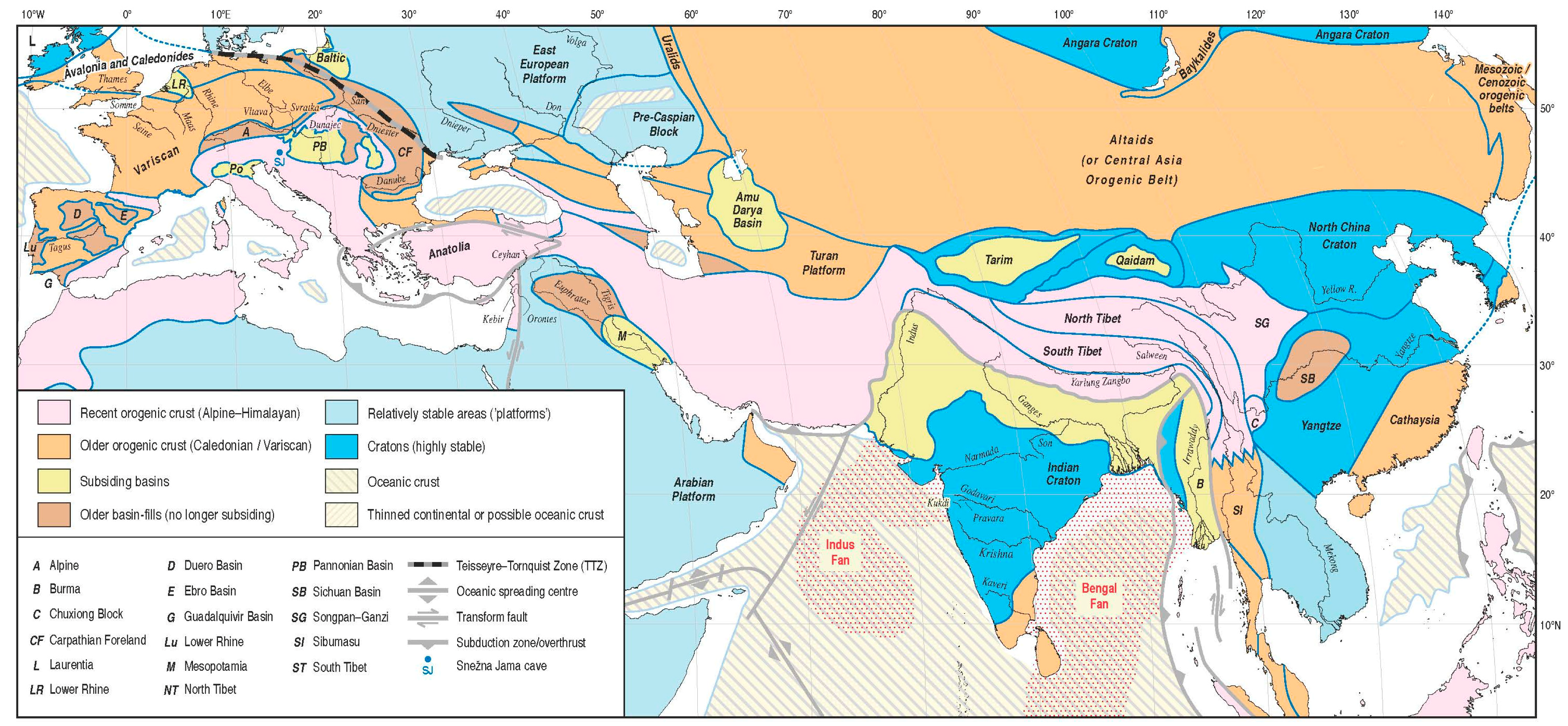
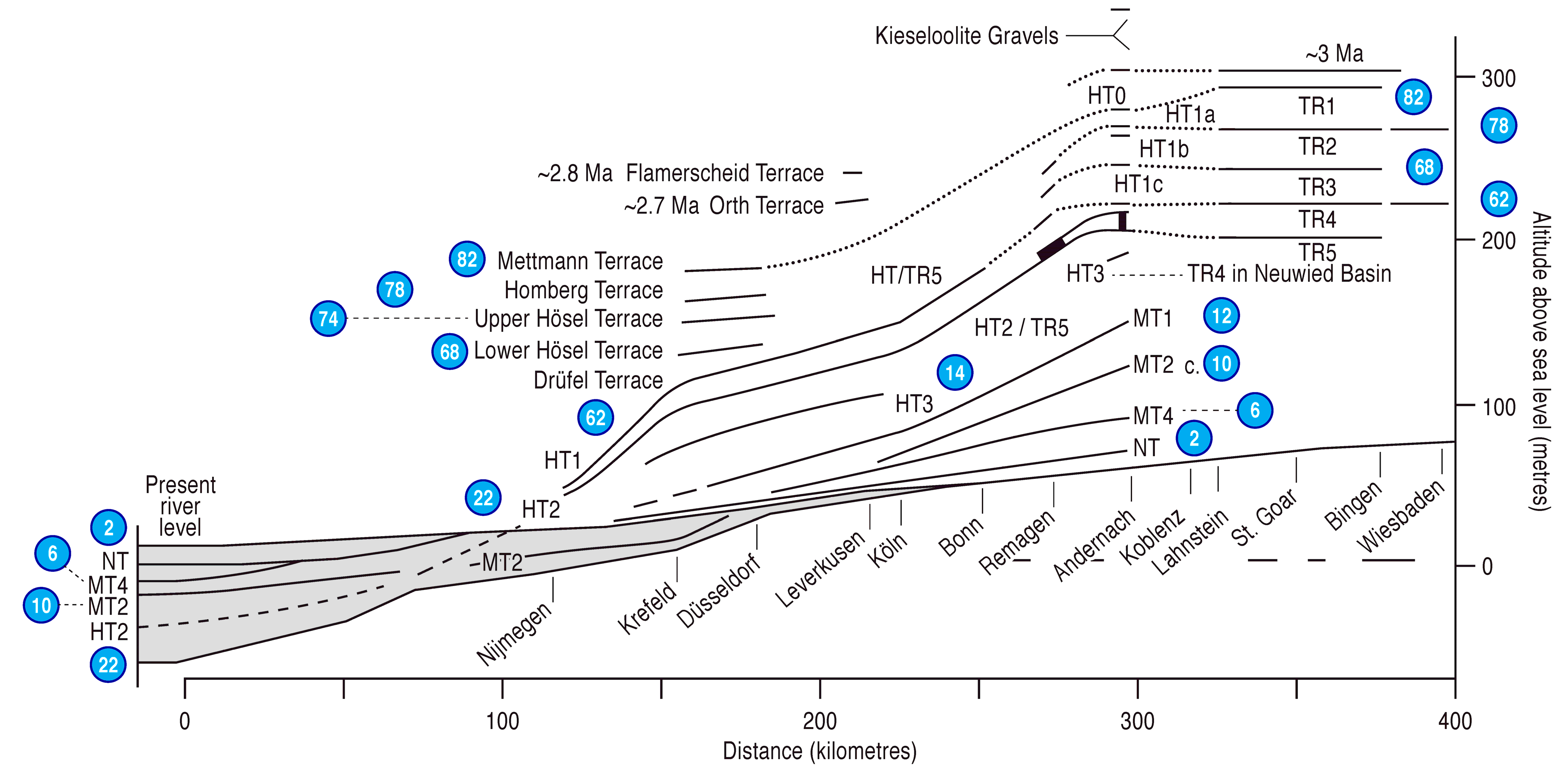
In recent decades, the formation of Quaternary fluvial terrace staircases has been associated with ‘epeirogenic’ vertical crustal motions within continental interiors [3,4,6,7,16,26,27,28,29]. Such uplifting areas occur worldwide, but not everywhere. They are commonplace in the interiors of tectonic plates, suggesting that the uplift cannot be attributed to plate-tectonic activity, despite contrary suggestions (e.g., [30]). Indeed, there are several examples that show that the effects of tectonic activity are very different from those of epeirogenic movement (e.g., [31,32]) Terrace staircases are widespread in Europe, although two of the continent’s largest rivers have reaches that show clear evidence that they have not been uplifting. Thus the Lower Rhine in the Netherlands is well known to coincide with a subsiding depocentre (Figure 1), with the terraces from upstream in Germany passing downstream into a stack of accumulated sediments with conventional ‘layer-cake’ stratigraphy (Figure 2) [33]. The Danube flows across a similar large subsiding basin, the Pannonian Basin, which formed as a result of subduction of the Carpathian Ocean in association with the formation of the Carpathian fold-mountains [30]; its infilled surface forms the Great Hungarian Plain (Figure 1) [34]. There are also smaller fault-bounded basins within the upstream parts of Rhine Graben that have been subsiding relative to adjacent terraced valley reaches, such as the Neuwied Basin [35,36]; small structural basins of this sort have generally been omitted from Figure 1.
The contrast between uplifting areas, with terraces, and subsiding areas, with subterranean stacked sequences, is not the only pattern apparent. Indeed, in non-subsiding areas, there are three characteristic patterns discernible, which can be related to different types and ages of continental crust (Figure 1) [5,51]. First, in Archaean cratons, there is evidence of considerable long-term stability, in that the pattern and disposition of fluvial sediment-body preservation implies minimal vertical crustal movement during the Quaternary. Second, in most other regions, including western and central Europe, there is evidence of progressive vertical motion, upwards in the case of areas that are not loaded by accumulating sediment. Many parts of Eurasia display combined sedimentary and geomorphological records that match this scenario, these being the areas in which the world’s best-documented long-timescale Late Cenozoic river terrace sequences are located, in some cases extending back for several millions of years (e.g., [52,53,54]). The third pattern of preservation can perhaps be regarded as intermediate between the other two, with a mixture of sediment stacking and terrace-staircase formation, with the latter never amounting to long continuous sequences, giving rise overall to little net change in valley-floor level during the latest Cenozoic–Quaternary. This pattern essentially shows alternation between uplift and subsidence on timescales of hundreds of thousands of years or more and it is typical of Early Proterozoic crustal provinces [3,4,6,55].
It has been shown that, in uplifting areas, the rates of vertical motion have varied over time, in phases that suggest correlation with patterns of climate change, leading to the suggestion that climatically induced changes in the rates of surface processes have influenced the crustal motion [3,4,5,6,56,57,58,59,60]. Any suggested mechanism for this effect needs also to factor in the differences in crustal movements observed from fluvial archives in contrasting crustal provinces. Erosional isostasy is a well known potential driver of progressive uplift [61]. Varying effectiveness of erosional isostasy in different crustal provinces can perhaps be accounted for by the differential operation of an important positive feedback mechanism: lower crustal flow, whereby mobile lower crust is squeezed from loaded, subsiding areas into unloaded uplifting areas [17,56,57,62,63]. The concept of lower crustal flow stems from the ‘jelly sandwich’ model of the continental lithosphere, which holds that the lower crust is weaker than either the upper crust or the mantle lithosphere [64,65,66]. This mechanism can explain the observed enhancement of uplift following significant deterioration of climate (cooling), such as occurred globally late in the Mid-Pliocene and again with the transition to 100 ka climate cycles at the Mid-Pleistocene Revolution (MPR). This works in terms of the increased rates of erosion and concomitant accelerated sedimentation in adjacent depocentres that would have occurred, thus accelerating the displacement of lower-crustal material from beneath sediment-accumulation areas to beneath the sediment sources [5,6].
An essential difference between modern ideas regarding erosional isostasy and the original form of this concept [61] concerns the relative magnitudes of forcing (i.e., erosion rates) and the associated response (i.e., uplift rates). Calculations [61], which are based on the assumption of conventional Airy isostasy, indicate that, although erosion will drive uplift, this is inevitably accompanied by a reduction in the spatially averaged altitude of the eroding landscape. On the contrary, when the effect of erosion-induced lower-crustal flow is taken into account, erosion can indeed drive uplift at a rate that exceeds the spatially averaged erosion rate of an eroding landscape [56]. As a result, erosion can drive not only uplift, but also surface uplift, meaning an increase in the spatially averaged altitude of an eroding landscape, or an increase in relief (if parts of the landscape remain at sea-level). Furthermore, if the lower-crustal rheology is linear, with viscosity independent of strain rate, then the flow rate in the lower crust will be proportional to the rate of forcing by erosion and/or sedimentation, even within the limit of the very low rates that have been observed in many intraplate regions (e.g., [56]). This mechanism can therefore cause surface uplift in such regions and the behaviour of isostatic models of this type [56] thus replicates the observed systematic worldwide increase in altitude and relief of landscape during the Late Cenozoic. These are represented by many examples, including those that are covered in the present review, in a manner that follows naturally, strongly suggesting that this general approach, incorporating lower-crustal flow, is on the right track (e.g., [59]). However, others have been slow to recognize this reasoning [58], accepting that erosion rates have increased as a result of climate change during the Late Cenozoic, and that relief has correspondingly increased, but expressing no view as to whether these changes have been associated with surface uplift and offering no opinion regarding the causal mechanism coupling landscape response to climate change. Signals have been sought in the remote, secondary situations of offshore fans (e.g., [67]), overlooking the availability of direct evidence from numerous fluvial archives across the world, which can provide much better age-control for phases of uplift that can be inferred to result from increased erosion (as discussed above). Others (e.g., [68]) have even disputed the view that erosion rates have increased during the late Cenozoic, but nonetheless accept that uplift has occurred, implying that they consider uplift and erosion to be independent processes with no causal connection.
The understanding of these mechanisms and the patterns of landscape evolution that they produce are of considerable importance to Quaternary stratigraphy. The case studies of fluvial-system stratigraphies that will be presented below, and which have provided the evidence from which the main insights have come, are well-dated exemplars amongst numerous other well-developed sedimentary archives that, for various reasons, are less well constrained temporally, and, as a result, are less well understood. Some may lack the bedrock geology that would have provided lime-rich groundwater, promoting the long-term (Quaternary-timescale) preservation of the vertebrate, molluscan and other calcareous fossils that are important for biostratigraphical age constraint (e.g., [10,69,70,71,72]). Another important bedrock-related factor is the presence or otherwise of lithologies that are suitable as raw material for Lower and Middle Palaeolithic tool-making, without which well-developed artefact assemblages and related stratigraphies are unlikely to exist. Most river systems will have sediments rich in the quartz sand that provides the basis for optically stimulated luminescence (OSL) dating, which is the most extensively used geochronological technique for fluvial archives, although infrared-stimulated luminescence and cosmogenic nuclide methodologies are fast gaining ground (e.g., [73]); some rivers have been affected by Quaternary volcanism, which has produced interbedded tephra and lava that can be dated with the reliable argon–argon geochronological method [74,75,76,77,78]. In systems with well-developed fluvial sedimentary archives but a dearth of dating evidence, it is possible to apply uplift–incision computer-modelling techniques [56,49] to generate an age model for the terrace (morpho) stratigraphy, which can be calibrated by any available indication of age for particular elements within the system, and, failing that, can be matched to patterns of terrace development in systems that are better dated and which occur in comparable crustal provinces and climatic zones (cf., [3,4,5]). It is important to note, in addition, that the examples expounded upon in this paper are dominantly from intraplate regions, where the only viable mechanism for driving and sustaining vertical crustal motions is the lower-crustal displacement described above, giving rise to ‘regional’ or ‘epeirogenic’ uplift rather than the increases in relief that can occur in plate-boundary zones as a result of plate-tectonic processes or the effects of active faulting. The latter can of course also give rise to localized vertical crustal motions, often overprinted onto a regional (epeirogenic) pattern of movement (e.g., [31,77,79]). A discussion of mechanisms of tectonic/atectonic uplift is not fundamental to this review paper, which is not the place to expand upon the various models. Readers are instead referred to the relevant papers in the Reference List.
2. Example Eurasian Records from Areas of Dynamic Crust
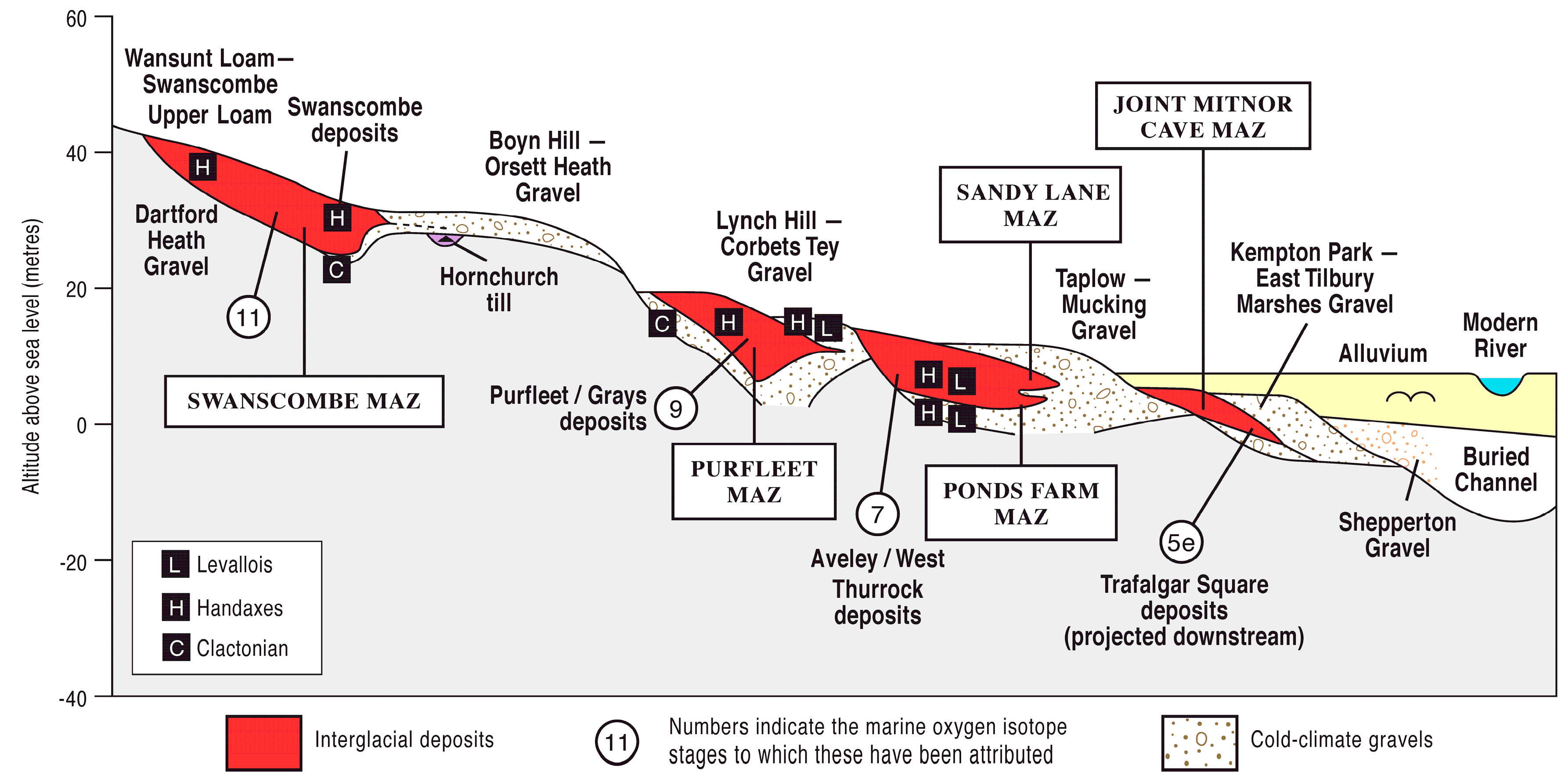
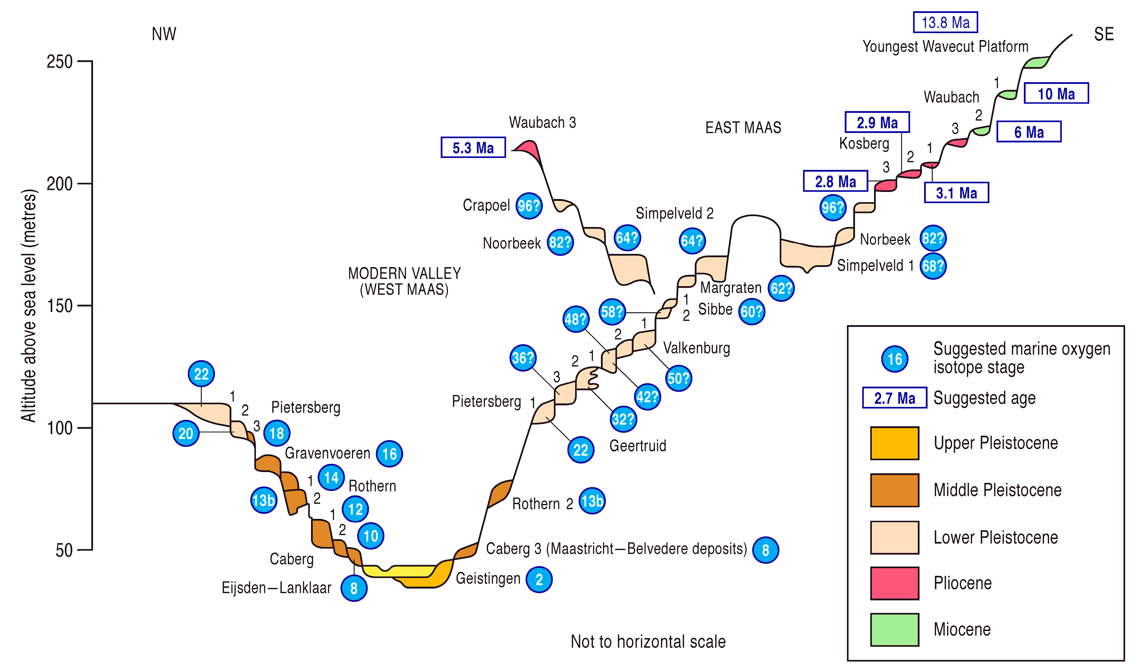
Western Europe boasts many of the world’s best documented and most significant Quaternary river terrace sequences, amongst which are the classic records from which the modern understanding of Pleistocene landscape evolution and considerable advances in terrestrial stratigraphy have arisen. In the north-west of the continent, these include the sequences from the Thames, UK, with its biostratigraphical and Palaeolithic richness (Figure 3) [7,80,81,82], the Somme and Seine–Yonne systems in France, with similar riches and the addition of loess–soil overburden sequences [25,83], and the Maas, in the southernmost Netherlands, which can claim the largest number (31) of terraces of any world river, with a sequence within which the effects of both the mid-Pliocene cooling and the MPR are well illustrated and can be dated with some precision (Figure 4) [6,49,50,84,85]. The Rhine and its tributaries also have important river-terrace archives (e.g., [3,49,86,87,88,89]). Further south in western Europe, river-terrace sequences are well developed on the Iberian Peninsula [90,91,92,93,94,95,96,97,98], where again they are often the context for important Palaeolithic artefact records [98,99,100,101,102]. Parts of this peninsula are sufficiently close to the African–European plate boundary for an influence from tectonic activity to have been invoked in explanation of the disposition of fluvial archives, e.g., in the Almeria, Sorbas, Tabernas, and Vera basins of SE Spain [103]. Nonetheless, the calculated amounts of late Quaternary uplift in those systems compare closely with those from a similarly dynamic crust in NW Europe [3,4].
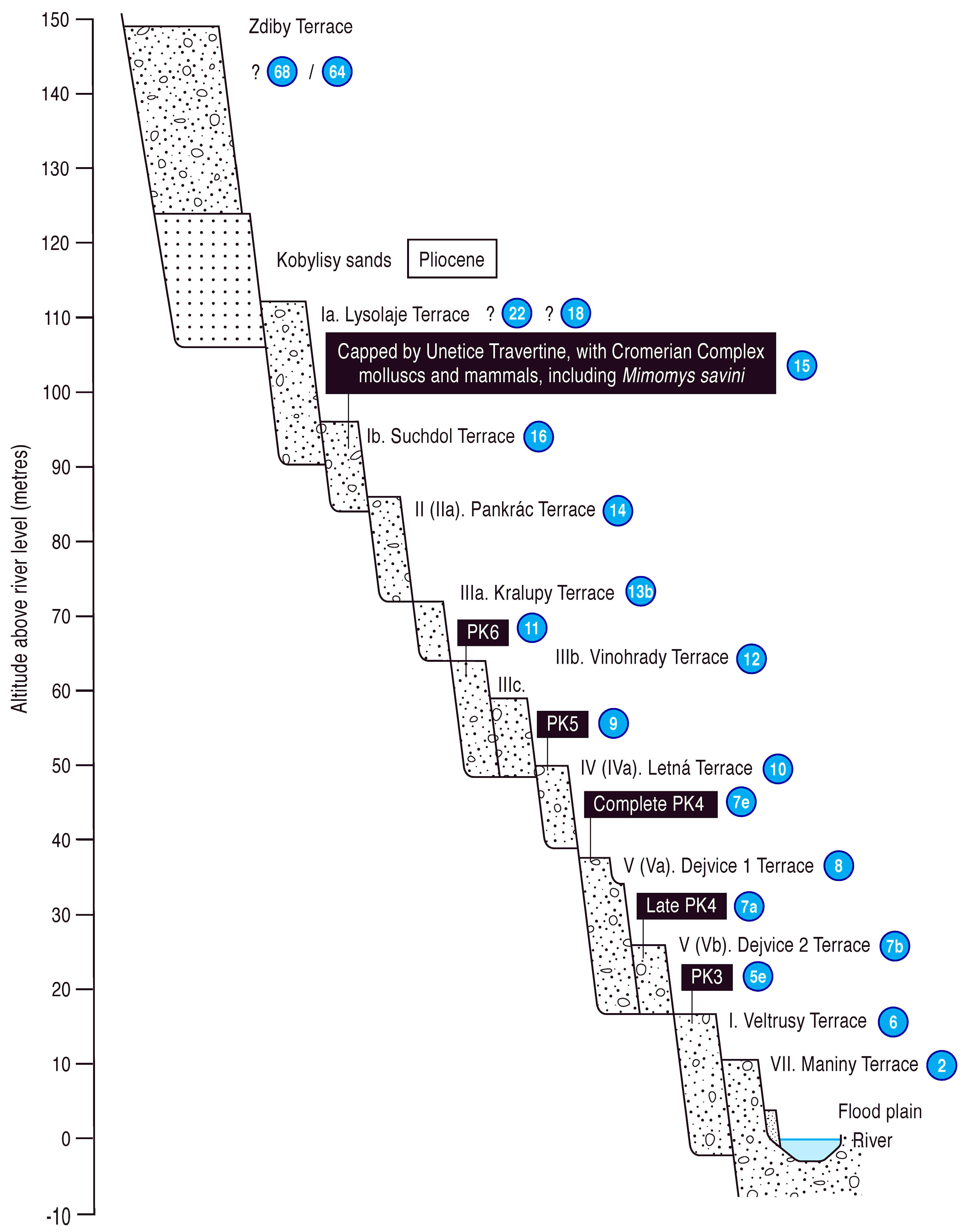
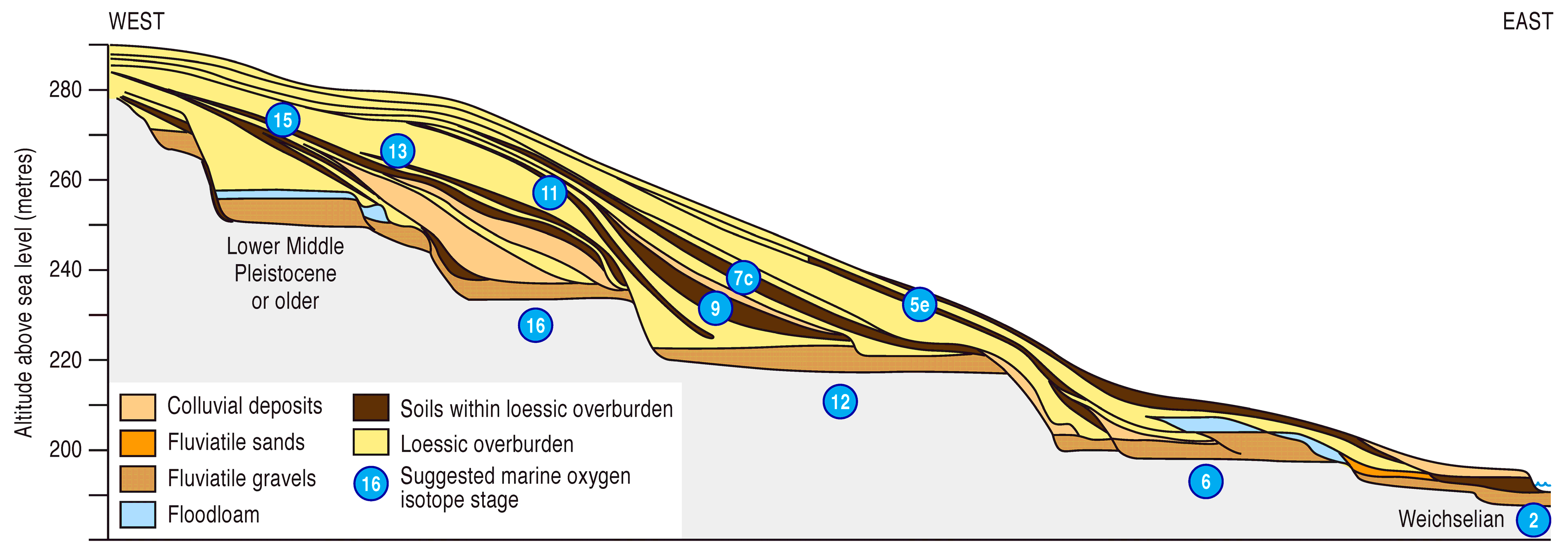
From the number and disposition of their terraces it can be inferred that many rivers in western Europe have, since the MPR, formed terraces at approximately one per 100 ka climatic cycle; again the Thames is a good example (Figure 3), as are the Somme and Seine [25]. In the case of the Maas, it has been suggested that more than a single terrace was formed during some Middle Pleistocene cycles (Figure 4) [50,104], whereas the (now-drowned) River Solent in southern England appears to have produced roughly two terraces in each of the last four 100 ka cycles [63]. Similarly, the Vltava, in the Czech Republic, has formed more than one terrace per 100 ka cycle during the Middle and Late Pleistocene (Figure 5) [105]. Further east, the Svratka, a Danube tributary that flows through Brno, has fewer Middle–Late Pleistocene terraces than one per 100 ka cycle. This system is dated with reference to the loess–soils overburden sequence that covers the fluvial deposits at the famous ‘Red Hill’ in Brno (Figure 6) [22,24]. It has been suggested [3] that the Svratka terraces correspond with the most pronounced climatic oscillations, those identified as ‘supercycles’ [106]; essentially those containing the marine oxygen isotope stages (MIS) that correspond with the ‘Donau’, ‘Günz’, ‘Mindel’, ‘Riss’, and ‘Würm’ alpine glaciations ([107] cf. [108]).
The Danube, Europe’s second largest river, flows through diverse crustal blocks that have experienced contrasting Quaternary evolution, some forming subsiding basins in which sediment has been accumulating (e.g., the Great Hungarian Plain: see above), whereas others have been uplifting and have staircases of terraces (see [34] for a review). In the uplifting reach upstream of the Great Hungarian Plain, through the Transdanubian Mountain Range, there seems to have been a terrace formed in most but not all late Middle–Late Pleistocene climate cycles, with both MIS 8 and 6 represented [3,109], as well as being marked by karstic levels within the limestone mountains [110]. Other rivers in the central–eastern part of Europe with well-developed terraces systems, in which most post-MPR climate cycles are separately represented, include several draining from the Carpathian Mountains, such as the Dniester, San, and Dunajec [32,52,111,112,113,114,115].
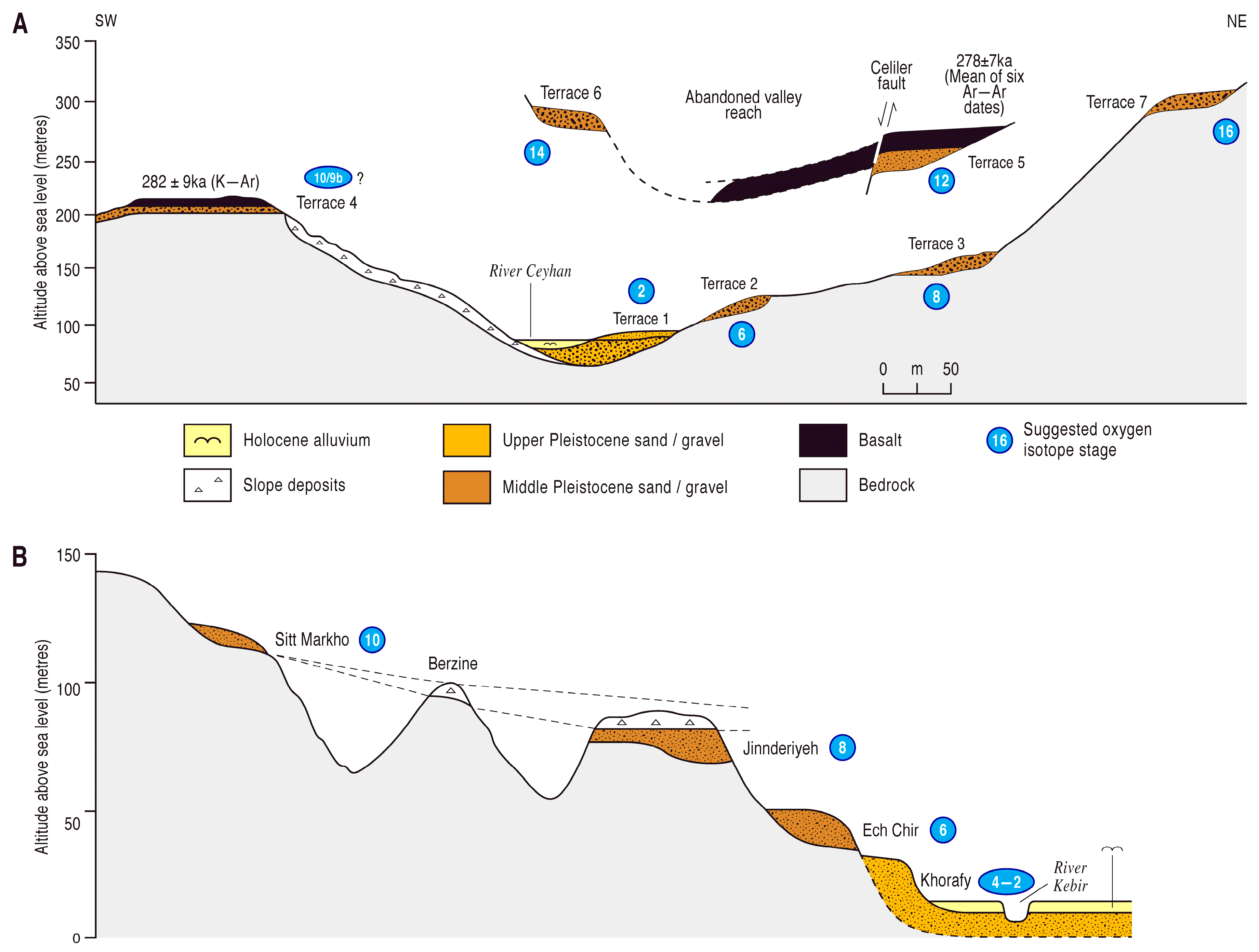
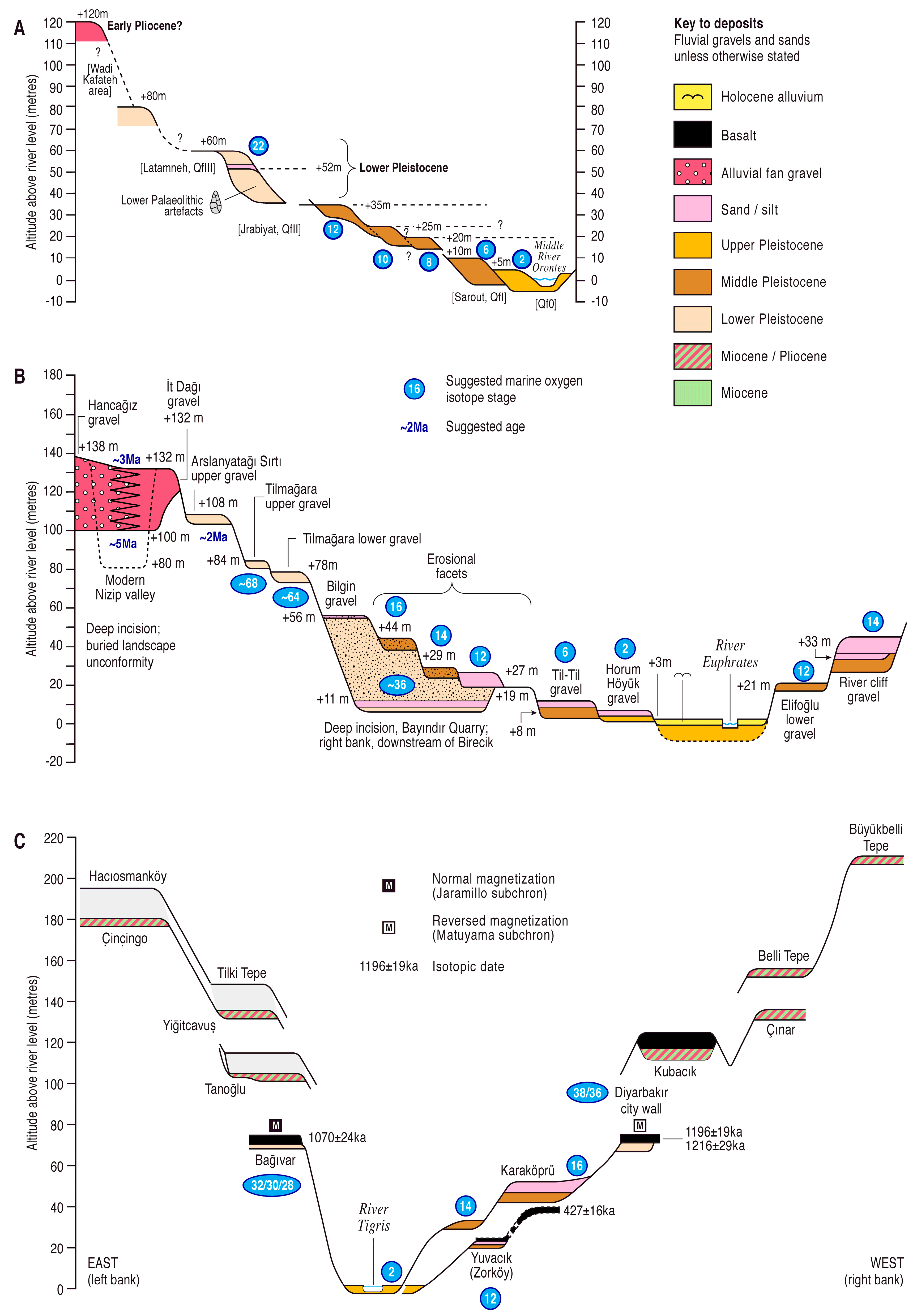
Young, dynamic crust also extends throughout the tectonically active Mediterranean region, where terrace staircases, both marine and fluviatile, are found in Italy [17,116], Bulgaria–Greece [5,117,118], and Turkey–Syria [18,119,120]. Turkey straddles the boundary between Europe and Asia, and terrace sequences indicative of particularly rapidly uplifting crust have been detected here in the Mediterranean coastal region from the İskenderun Gulf, east of Adana, through Hatay and into the NW corner of Syria, in the region of Latakia [18]. The dynamic crust of the wider Mediterranean region results from its deformation in response to the convergence of the African and Eurasian plates and subduction of the Tethys Ocean (e.g., [121,122]), although the reason for the rapidly deforming crust of the Adana–Latakia area, with an uplift rate of ~0.1–0.4 mm a−1 during the latest Middle and Late Pleistocene [18], is less clear. The evidence for this exceptional uplift comes from the terrace sequences of the Ceyhan and the lowermost Orontes in Turkey and the Nahr el Kebir in Syria, the first of which is well constrained by the Ar–Ar dating of basaltic lava emplaced above fluvial deposits down to the fourth terrace (of seven), ~90 m above floodplain level, to 278 ± 7 ka, i.e., within MIS 9 (Figure 7A) [77]. Indeed, this same volcanism has armoured the landscape around the Ceyhan course through the Amanos Mountains, preventing the complete destruction by erosion of earlier Middle Pleistocene fluvial deposits, as has occurred in the Orontes and Kebir, where the combination of rapid uplift and concomitant denudation has resulted in only the youngest few climate cycles being represented in the preserved terrace staircases (Figure 7B) [18]. It has been suggested (e.g., [123]) that terrace formation will have been limited in areas of very rapid uplift, such as New Zealand [124,125,126,127].
Another case study that has received attention as part of FLAG activity, in this case under the auspices of IGCP 518 (see above) [6], concerns an area of China with relatively rapid fluvial incision, in response to rapid uplift: the Middle Yangtze region in Yunnan. This was visited during the IGCP 518 conference/field meeting to Nanjing and the Yangtze in October 2006. Evidence from river terraces near the entrance of Tiger-Leaping Gorge, where the Yangzte traverses the Yulong mountain range, taken in combination with geomorphological and thermochronological techniques, has been used to estimate the rates of uplift in this region [128]. The area in question can be defined as the western part of the Yangtze crustal province, also known as the Chuxiong Block, which is located to the SE of the Tibetan Plateau and east of the eastern Himalayan syntaxis (Figure 1). The Tibetan plateau is a region of ~3 million km3, which is characterized by high topography (~5–6 km above sea level (a.s.l.)) and with extreme crustal thickness (up to ~70 km), with the latter thought to result from inflow of mobile lower crust from the south in response to the convergence between the Indian and Eurasian plates (e.g., [129,130]). This extreme build-up of crustal thickness has been facilitated by Tibet being surrounded by crust with dominant properties of relative coldness and high strength (such as the Indian craton to the south, the Yangtze craton to the east, and the Tarim crustal province to the north and west (Figure 1)); these surroundings have helped to constrain the thickening crustal block and promote the elevation of the plateau. The uplift of the Tibetan Plateau has been related to the intensification of the Indian monsoon from ~8 Ma [131] and it has been calculated [130] that if all the crustal volume flux arising from the convergence between India and Eurasia had been converted into crustal thickening beneath Tibet (with none escaping), the resultant uplift rate of the land surface would have been ~0.3 mm a−1.
3. Contrasting Records from Less Dynamic Crust: The East European Plain, Arabian Platform and Cratonic Regions Such as India
Important differences in the patterns of river-terrace preservation are observed in areas eastwards from those described above. In northern and central Europe, these relate to crustal differences that are associated with the crossing of the Teisseyre–Tornquist zone (TTZ), also called the Trans-European Suture Zone (marking the suture of the former Tornquist ocean (e.g., [132]), which runs NW–SE through Poland and western Ukraine and separates the relatively young and dynamic crust of the area described above (Variscan and younger) from the much older (Proterozoic) crust of the East European Platform to the NE (Figure 1). This important geological boundary, which marks a considerable difference in heat-flow and temperature at the mantle–crust transition (e.g., [55,133]), thus separates regions with significantly different Quaternary landscape evolution histories, as demonstrated by their river-terrace records. To the west of the suture, such records invariably point to monotonic Late Cenozoic vertical crustal motion, generally progressive uplift, as is consistent with the younger, dynamic crustal type, which has a mobile lower layer >10 km thick, beneath ~20 km of upper-crust (cf. [3,4,5,50,55]). To the east of the suture, there is evidence of alternations of uplift and subsidence over timescales of many hundreds of thousands of years, with little net crustal motion in either direction, as exemplified by the sedimentary archives of rivers such as the Vistula in central Poland [32], in the north, and the Dnieper and Don, rivers flowing southwards to the Black Sea [52]. Further east the East European Platform extends to the Urals, largely drained southwards by tributaries of the Volga, the latter entering the Caspian Sea across the ultra-stable pre-Caspian Block, which is thought to include a component of oceanic crust (Figure 1) [1,134].
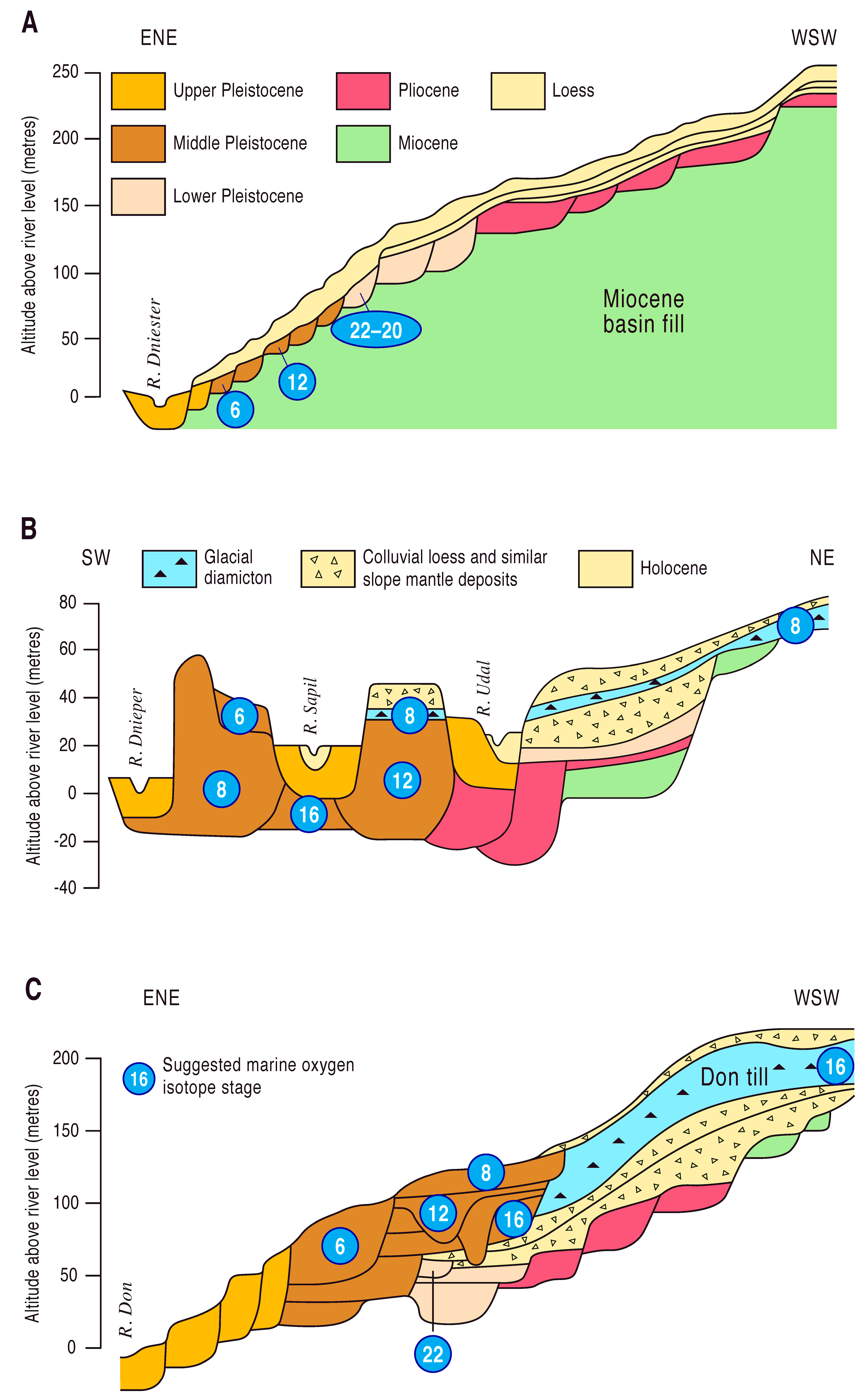
The contrast between the two sides of the TTZ is well illustrated by the stark differences between the fluvial archives of the large south-flowing rivers of the Black Sea region, which, fortuitously, are also important repositories of stratigraphical data that is well constrained in terms of age, thanks to a combination of biostratigraphy (vertebrates and Mollusca) and geochronology (multiple techniques, including magnetostratigraphy); these are, from west to east, the Dniester, Dnieper, and Don (Figure 8) [3,4,5,32,52,55,113]. There are also important loess–palaeosol sequences occurring as overburden above the fluvial archives, providing a further check on the age constraint for the latter, and two important glacial episodes are also recognized, named after two of the rivers (Don and Dnieper), their sediments interbedded with the fluvial archives (Figure 8B,C).
The River Dniester has its course immediately west of the East European Platform and has a staircase of terraces that records continuous uplift since basin inversion during the Mid-Pliocene, before which there had been accumulation of fluvial sediments within the northern part of a larger Black Sea (or ‘Paratethys’) Basin: the Upper Miocene Balta Series (Figure 8A) [3,5,52,135]. Although this would seem to represent sedimentary isostatic subsidence, the Balta Group was accumulating as the ‘coastline’ of the landlocked ‘Paratethys Sea’ retreated southwards towards the present Black Sea. Thus, the ancestral Dniester was probably forced to aggrade to maintain its gradient, forming a stacked sequence that does not necessarily imply concomitant subsidence [5].
Neither of the other two rivers (Dnieper or Don), both situated well east of the TTZ, show this staircase pattern of river terrace preservation. Instead their sedimentary records imply that there have been alternations in the sense of vertical crustal motions, with little or no net uplift during the Quaternary (Figure 8B,C) [3,52]. Each of these rivers has a different pattern of fluvial-archive preservation. The Dnieper, ~300 km east of the Dniester, has a depositional archive in which sediment bodies of various ages, many of which can be correlated with the regimented terraces of the Dniester, occupy positions in the landscape that lie between ~40 m below and ~50 m above the modern valley floor (Figure 8B). These show no clear relation between age and elevation, but instead would appear to record alternating episodes of uplift and subsidence, with preservation also predicated by lateral migration of the river and its tributaries, the horizontal extent of the terrain represented by the summary diagram (Figure 8B) exceeding 200 km [5,55,113]. This type of preservation pattern, suggestive of little net vertical crustal motion during the Quaternary, is typical of the ancient ‘cratonic’ crust of continental cores, dating from the Archaean; similar evidence has been observed from cratons in South Africa and India, where early Pleistocene or even pre-Quaternary fluvial sediments are close to, or even below, modern river levels [4,51]. In the case of the Dnieper, the craton in question is the Ukrainian Shield [136]. It has been noted [5], when comparing the records from Dniester and Dnieper systems, that the marked contrast in valley evolution they record can only have resulted from the different crustal stability on either side of the TTZ, there being little difference in the climate and hydrological properties of their catchments. The crustal properties of the Ukrainian Shield and their effect on landscape evolution has been discussed at length [55]; in fact, the course of the lowermost Dniester, with its terrace staircase, lies ~50–200 km NE of the TTZ (Figure 1), seemingly within the stable zone of the East European Platform. However, the crust in that area experienced later regional metamorphism and igneous intrusion, and so it was not fully cratonized during the Archaean. Furthermore, the ancient crust in this area is deeply buried by later sediments, which has the effect of raising its temperature and therefore its potential for lower-crustal mobility [55].
The final river in the west to east transect across this region is the Don, which flows through SW Russia, traversing the ‘Voronezh Shield’ or the ‘Lipetsk–Losev crustal domain’, representing the Early Proterozoic (~2300–1900 Ma), with no evidence of older Archaean material. The Don sequence dates back to the late Middle Miocene (Sarmatian Stage of the Paratethys realm). The summary diagram (Figure 8C) shows evidence for lengthy periods of uplift, represented by terraces, interspersed with episodes of subsidence during which the earlier terraces were buried. Thus, an initial terrace staircase, spanning the late Middle Miocene to the latest Pliocene, was formed during a period of steady uplift, but was subsequently buried beneath younger deposits, which accumulated during a phase of subsidence that began at ~2 Ma. Renewed uplift, as indicated by incision, was followed by further aggradation and the accumulation of a stacked fluvial succession interbedded with loess layers, palaeosols, and the deposits of the MIS 16 Don glaciation (Figure 8C). This accumulation culminated in MIS 8 (250 ka), when renewed incision left the capping sediments as the fourth terrace and progressed to the modern valley depth, forming the lowest terraces of the of the Don. This sequence has been explained in terms of interactions between conventional Airy isostatic compensation involving flow in the mantle and the aforementioned isostatic compensation by lower-crustal flow; these have different characteristic response times [55], with the repeated alternations of uplift and subsidence, as evidenced by the Don fluvial sequence, considered to be characteristic of crustal types in which the lower mobile layer is of highly restricted depth. This is typical of Lower Proterozoic crust, as here in the Voronezh region, but also occurs where the crust has experienced significant mafic underplating, as in rather younger crust of the Arabian Platform (see below). Indeed, seismic profiling has indicated that crust of the Voronezh Shield has a basal layer with a P-wave velocity of 6.95–7.8 km s−1 [137], which is consistent with mafic underplating. There are various problems in determining the crustal characteristics of this region [55], which probably has a thin mobile layer, in approximate agreement with the previous calculations (cf. [3]).
The comparison of these three fluvial sequences thus shows stark differences. The Dniester has a standard river-terrace staircase, with most 100 ka climate cycles since the MPR being represented, as well as high-level terraces representing the Pliocene and Early Pleistocene (Figure 8A). The sedimentary records of the Dnieper and Don have considerably more restricted altitude ranges, with the Dnieper being the more restricted of the two. Its succession (Figure 8B) is also less complete, notably having no deposits between the earliest Pliocene (the Parafiivka Formation) and the early Middle Pleistocene (the Traktemyriv Formation). In the Chornobyl district, ~200 km upstream of the sequence illustrated in Figure 8B, a ~35 m stacked fluvial succesion (the Chornobyl Formation) overlies the Parafiivka Formation and it is thought to represent the late Early Pliocene and Middle–Late Pliocene, although the Early Pleistocene is still lacking [52]. Downstream from the illustrated sequence, the Dnieper flows for ~400 km ESE along the Dnieper Basin, and then turns to the SW to reach the Black Sea by way of its ~300 km long ‘Lower Dnieper’ course, where the sedimentary sequence is even more closely spaced altitudinally [52], suggesting even greater crustal stability. This has been attributed to the Archaean crust beneath the lowermost Dnieper course [55], which has a lower heat-flow (cf. [138]) and an evidently constricted the mobile lower layer, perhaps completely missing in some places (cf. [51]).
To the south and south-east, there are valuable comparisons to be made between the highly dynamic crust that has been deformed by Alpine orogenic activity, which extends from western Syria across most of Turkey and southern-central Asia towards the Himalayas, separating the East European Platform from a comparable stable region further south, the Arabian Platform, which underlies central-eastern Syria and the southern fringe of central Turkey (Figure 1). This latter province is essentially similar to the East European Platform in terms of its properties, with mafic underplating and/or a narrow depth of mobile lower crustal material, often of limited effect. Thus the river terrace records from the Rivers Euphrates and Tigris, where they flow through this province, show evidence of alternating uplift and subsidence, or uplift and stability (Figure 9) (e.g., [5,18,54,78,139,140,141]), in a manner that is reminiscent of the Don (see above). The Orontes, already seen in its lowermost reach, flows northwards from Lebanon through Syria and Turkey, crosses into the stable interior of the Arabian Platform in its middle reach (Figure 1 and Figure 9A) before entering that region of rapidly uplifting crust described above, around and downstream of Antakya in Turkey [18,119]. In north-western Syria and immediately downstream of the border with Turkey, the river passes through two small pull-apart basins that have experienced long-term subsidence, possibly throughout the Quaternary [119], another example of small structural basins of insufficient size to be depicted in Figure 1. The Arabian Platform covers the entire Arabian Peninsula to the south (Figure 1), so comparable sedimentary archives might be anticipated there, although the history of long-term aridity and resultant absence of modern-day perennial rivers explains the paucity of data, despite the importance of the region as an archive of Quaternary environmental change [72,142,143].
Much of the crust further to the east belongs to the orogenic belts of the Himalayan massif, the Tibetan Plateau, and, further north, the Altaid collage (Figure 1). To the south of these orogenic regions, however, is a further ultrastable peninsula, that of the Indian subcontinent. The Indian peninsula is an Archaean craton that was one of the first to be recognized as ultrastable in terms of its Late Cenozoic fluvial archive record, with pre-Quaternary alluvial sediments at near river level in the valleys of rivers such as the Kukdi, Narmada, Pravara, and Son [3,4,51,145,146,147,148]. The main line of evidence for dating these ancient fluvial deposits, apart from weathering of their components and of bedrock below them, was Palaeolithic artefacts, although dated tephra deposits from Toba in Sumatra, which are also found near modern river level, have provided support [148,149,150], albeit controversial (cf. [151,152]).
4. Anomalous Records from Orogenic Belts in Central Asia
The orogenic belts of the Himalayan massif and the Tibetan Plateau are associated with the India–Eurasia collision, whereas the Altaid collage, also known as the Central Asian Orogenic Belt, is a huge area that experienced large-scale plate movement (including ocean-crust subduction) during the Palaeozoic, creating an agglomeration of different terranes, including island arcs (Figure 1) (e.g., [48,134]). There is a somewhat patchy documentation of fluvial archives from such regions, although the high mountain ranges are associated with deep foreland basins, such as that to the south of the Himalayas (Figure 1), which have experienced prolonged sediment accumulation, much of it fluvial or fluvio-deltaic (e.g., [45]). The recent plate-tectonically generated Himalayan orogenic belt comprises accreted terranes that are associated with the convergence of the Indian and Eurasian plates. These include the Tibetan Plateau (visited during the FLAG meeting that generated this publication), where a complex history of crustal accretion has given rise to west–east crustal extension on north–south striking normal faults, creating the present ‘basin and range’ landscape (see other contributions to this special issue). The accreted terranes, derived from the Gondwana supercontinent, are aligned west–east to the north of the Himalayan mountain range, turning towards north–south and extending, in attenuated form, into southern China (Figure 1). Here, they give rise to the ‘three rivers’ region, immediately east of the collision zone, in which the Salween, Mekong and Yangtze flow in deep parallel gorges within a few tens of kilometres of each other, and incised several kilometres beneath an uplifted low-relief palaeosurface [153,154,155,156]. This attenuation, which is presumed to have pre-dated gorge initiation, has been attributed to orogen-perpendicular crustal shortening and/or orogen-parallel stretching [156,157], the deeply incised valleys having been brought into greater proximity as a result of the attenuation of the crustal terranes to which they belong. Such drainage systems, being highly influenced by this tectonism, are anomalous in that they are not part of systematic patterns, as described in this paper, although the uplift that has led to the formation of these deep valleys is perhaps as much the result of crustal properties and lower-crustal processes as of the orogenic thickening of the crust; analysis of the Yangtze [128] indicates that the incision of these valleys is a consequence of regional crustal thickening in the absence of shortening, which is potentially attributable to movement of mobile lower crustal material beneath the region. Despite flowing in deep gorges, it has been suggested that the three rivers and their near neighbours and tributaries have also been involved in a complex history of drainage diversion and capture, part of the progressive enlargement westwards of the Yangtze, largely at the expense of the Red River [156].
Further west two other examples of the world’s great rivers are worthy of mention, although their records are equally anomalous. First, the Yarlung–Zangbo, which drains from Tibet and, becoming the Bhramaputra, through India to the Bay of Bengal in Bangladesh, having turned sharply southward from its original west–east course and flowed through a deep and steeply graded gorge reach; this course has long been attributed to drainage diversion by river capture, with the original downstream continuation of the modern Zangbo suggested to have been the lower Irrawaddy, or, further back in time, the Red River (Figure 1) [153,155,156]. In its middle reaches in Tibet, the Yarlung–Zangbo valley preserves a remarkable sequence of terraces and evidence for transitory glacially impounded lakes, with some of the higher terraces taking the form of thick (>200 m) sedimentary sequences akin to ‘perched basin-fills’ [158]. These early deposits, clearly representing the river in ancestral form, date back to pre-Quaternary times, leading to the claim [158] that this reach of the Yarlung-Zangbo has existed since the Miocene, presumably when it drained to the Irrawaddy or the Red River. The second noteworthy great river of the Himalayan orogenic region is the Indus, which has also been affected by river capture during the Late Cenozoic, gaining left-bank tributary rivers draining from the Punjab [159,160]. As it crosses the Himalayan mountain range, the Indus forms what is arguably the world’s deepest gorge, >5000 m deep, in the vicinity of the Nanga Parbat massif [155]. This provides a clear indication that this river has been ‘locked’ in its present course to the Arabian Sea throughout the Himalayan orogenesis, as is also evidenced from the provenance of sediments that were retrieved by offshore drilling in the Indus Fan (Figure 1) [159,160].
5. The Effects of Glaciation
There is little potential for comparison with areas further north from those described, as these have been repeatedly glaciated and long-timescale fluvial records are, as a result, generally absent, although again, this generalization is less well-established in Asia than in Europe. Given that sufficient precipitation is a requirement for the formation of glaciers, some northern and/or upland areas that have been sufficiently cold have seemingly escaped, or largely escaped, the effects of glaciation on account of their aridity, a prime example being large parts of the Tibetan Plateau (e.g., [161,162]). The influence upon river systems of interactions with glaciation, in both upstream and downstream areas, was reviewed recently, with the important role of deglaciation, with its (temporary) boosting of discharge and sediment supply, particularly noted [163]. Such fluvial–glacial interactions can also have a profound effect on the evolution of drainage patterns, since rivers can be diverted and even obliterated by glaciation; the recently elucidated evolution of the River Trent, in Midland England, provides a good example [164,165,166].
Notwithstanding the emphasis thus far given to variations in crustal properties as an influence on uplift rates, it is important to note for comparison the considerable difference in uplift rates that can result from the contrast between upland glacial erosion and extra-glacial surface processes within a single crustal province. By way of example, such a contrast has been revealed by recent research the SE margin of the Alps in Slovenia ([167,168]; cf. [59]). Here, in a high-altitude, formerly glaciated region, cave sediments that have been dated by magnetostratigraphy and cosmogenic dating have provided an insight into Late Cenozoic landscape evolution. The studied cave, Snežna Jama (Figure 1), is situated ~1530 m a.s.l. and ~950 m above the adjacent River Savinja, which is a tributary of the Sava, itself a right-bank Danube tributary. From analysis of its sediments, and by analogy with other caves, it can be inferred that Snežna Jama cave would have formed and been filled while close to local fluvial base level. Dating results have led to the conclusion that the cave was isolated from the local fluvial system [167], presumably by erosional valley-floor lowering, by ~1.9 Ma. It has been estimated [59] that the local post-MPR uplift rate might have been as high as ~1 mm a−1. In contrast, in the lowlands of the Ljubljana Basin <40 km from Snežna Jama, outside the maximum limit of Pleistocene glaciation [169], the oldest river terrace deposit (of another Sava tributary) is at 564 m a.s.l., 119 m above the modern river, and is likewise dated cosmogenically and from magnetostratigraphy to ~1.9 Ma [168]. The time-averaged local uplift rate thus indicated has therefore been ~0.06 mm a−1, with a maximum upper bound to the local uplift rate post-MPR of ~0.13 mm a−1. Both localities are in the same crustal province of Alpine age (Figure 1), the difference between them being that one has experienced glacial erosion and the other has not.
There is thus evidence from the above case study in support of the view that glaciation has had an important effect on erosion rates in glaciated regions [72]. Nonetheless, it also provides evidence for an increase in uplift and erosion rates during the Late Cenozoic in unglaciated regions, as demonstrated by numerous examples in this paper, albeit that these rates have been typically lower than in glaciated regions of equivalent crustal properties [59]. Furthermore, the contrasting localities in Slovenia are separated by the active Sava Fault [168], with downthrow towards the Ljubljana Basin, although it is currently unclear to what extent the dramatic variation in Quaternary uplift has been accommodated by slip on this fault or by tilting or warping of the adjoining crustal blocks. Moreover, it is also currently unclear whether this fault is accommodating plate motions (a small part of the relative motion between the African and Eurasian plates) or is slipping to relieve build up of stress as a result of the warping of the adjoining crustal blocks, in response to the different rates of surface processes that are being imposed on them [170].
6. Discussion: The Influence of Crustal Province on Erosion Rates and Patterns of Stratigraphical Disposition and Preservation of Fluvial Sediments
The different styles of fluvial archive preservation in the different parts of the Eurasian continent are an important consideration in the understanding of Quaternary stratigraphy in these regions, given that fluvial sequences provide valuable templates for the Late Cenozoic terrestrial record [5,8,27]. There are significant differences between these patterns of preservation that point to important contrasts in landscape evolution, in particular, relating to the extent of valley incision [6,51]. These have important repercussions for Quaternary stratigraphical data from other environments. Thus, the occurrence of karstic caves, with their important records of fauna, hominin occupation, and datable speleothems, is directly related to valley incision, paralleling underground the records of progressive down-cutting provided above ground by river terraces [59,60,171,172,173,174,175]. Furthermore, the preservation patterns of fluvial archives have a direct bearing on the likelihood of preservation of evidence from ancient lacustrine and other terrestrial environments, since the former document the extent of, and likely loss to, erosional processes, which will be substantially greater in areas of dynamic and rapidly uplifting crust.
From their distribution, especially in Europe, it is clear that the different preservational patterns of fluvial archives are related to crustal type, with progressive and extensive vertical incision being evidenced from fluvial sequences in regions of relatively ‘young’ dynamic crust, whereas older crust generally has greater stability and has seen much less valley deepening by rivers, if any at all (see above). These different patterns of fluvial archive preservation can be matched to the different crustal provinces. As has been seen, the most stable regions, in which the fluvial archives suggest a complete or near absence of net uplift during the Quaternary, coincide with the most ancient cratonic crustal provinces, such as peninsular India and parts of the East European Platform, in particular the Ukrainian Shield (Figure 1 and Figure 8). Such highly stable regions are the exception in the case of the East European Platform; however, over much of this crustal province, there has been limited net uplift as a result not of ultra-stability but of alternations of vertical crustal movements, resulting in periods of terrace generation with intervening periods of subsidence and burial. Such patterns are seen as far west as eastern Poland, to the north of which is an area of general subsidence, at the margins of the Baltic Basin [32]. The difference between the fluvial records from the East European Platform and those from the youngest and most dynamic crust are quite profound, although many of the comparisons above are with crust of somewhat intermediate age, such as the Variscan and Avalonia provinces (Figure 1). This is because a large part of the youngest crust, such as the Alpine and Carpathian provinces, remains tectonically active and so has fluvial archives that are less clearly related to regional vertical crustal movements.
The patterns are less clear in Asia (excepting India), despite the well-known occurrence of terraces in the valleys of many of the larger rivers, including the Huang He (Yellow River), the inspiration for the meeting from which this special issue arises [53,176]. In the very high relief areas of much of central Asia, the fluvial response to uplift will have been gorge incision, with only sporadic terrace formation, such as described above for the Middle Yangtze [128] and the Yarlung-Zangbo [158]. As already noted for Europe, the active tectonic processes in these areas make the interpretation of the fluvial archives and their relation to other forcing effects problematic. Asia also has a greater proportion of highly stable cratonic crust (Figure 1); the combination of this and the dominantly arid climate regimes of inland area has led to the persistence of endorheic drainage systems, which are probably characterized by subsidence (cf. [177]), such as the cratonic Tarim Basin (e.g., [58]). A feature of the Yellow River system is that its upper reaches pass through the basins and ranges of the high-altitude Tibetan Plateau, many of them endorheic earlier in the Quaternary and several remaining so, in total or in part [176,178,179,180].
7. Conclusions
It has been shown that crustal properties have a very important influence on the style of fluvial archive preservation, which is linked to their role in determining patterns of landscape evolution. Thus, the staircases of river terraces familiar in many parts of Europe, and from which much stratigraphical information (including biostratigraphy and Palaeolithic artefact sequences) is derived, are largely confined to the younger and more dynamic crustal provinces, whereas more ancient, stable crust has not undergone the progressive Quaternary uplift that is required to generate such flights of fluvial terraces. Some ancient crust, such as in the East European and Arabian Platforms, has been subject to periodic uplift, such that combinations of river terraces and limited stacked sequences are observed. The patterns of differential preservation, which have important implications for understanding and resolution of Quaternary stratigraphy, appear likely to result from the movement of lower crustal material from beneath areas under isostatic load to beneath adjacent areas undergoing Quaternary erosion, thus acting as a positive-feedback driver that sustains the uplift generated by denudational isostasy in these latter areas. This uplift has accelerated through coupling between crustal and surface processes, in response to global cooling in the late pre-Quaternary and again as a result of the greater climatic severity as part of the 100 ka cycles that followed the Mid Pleistocene Revolution. The patterns are less clear-cut in Asia, where much of the crust has been (and/or continues to be) subject to plate tectonic processes.
Supplementary Materials
The following are available online at https://0-www-mdpi-com.brum.beds.ac.uk/2571-550X/1/3/28/s1, Figure S1: Crustal provinces of the Eurasian continent; large-format version.
Author Contributions
Conceptualization, field data collection (Turkey and Syria) T.D., D.B. and R.W.; Methodology and Writing-and Reviewing Original Draft, D.B. and R.W.; Software, R.W.; Funding Acquisition (dating in Turkey and Syria) and presentation of oral version at INQUA 2015, T.D.
Funding
The dating of basalts in Syria was supported by HUBAK (Harran University Scientific Research Council), project 442 (T.D.). Fieldwork in Syria was supported by the Council for British Research in the Levant (serial small travel grants to D.B.)
Acknowledgments
In addition to the above-mentioned funding, Chris Orton of the Department of Geography, Durham University, is thanked for production of the figures. We would also like to thank two anonymous referees for constructive comments that have led to improvements in the paper. The synthesis included here was facilitated by the successive UNESCO-funded International Geoscience Programme (IGCP) projects, Nos 449 and 518, co-led (under the auspices of FLAG) by DB, respectively entitled ‘Global Correlation of Late Cenozoic Fluvial Deposits’ (2000–2004) and ‘Fluvial sequences as evidence for landscape and climatic evolution in the Late Cenozoic’ (2005–2007).
Conflicts of Interest
The authors declare no conflict of interest.
References
- Nikishin, A.M.; Ziegler, P.A.; Stephenson, R.; Cloetingh, S.; Furne, A.V.; Fokin, P.A.; Ershov, A.V.; Bolotov, S.N.; Korotaev, A.S.; Alekseev, A.S.; et al. Late Precambrian to Triassic history of the East-European Craton: Dynamics of Basin Evolution. Tectonophysics 1996, 268, 23–63. [Google Scholar] [CrossRef]
- Cloetingh, S.A.P.L.; Ziegler, P.A.; Beekman, F.; Andriessen, P.A.M.; Matenco, L.; Bada, G.; Garcia-Castellanos, D.; Hardebol, N.; Dezes, P.; Sokoutis, D. Lithospheric memory, state of stress and rheology: Neotectonic controls on Europe’s intraplate continental topography. Quat. Sci. Rev. 2005, 24, 241–304. [Google Scholar] [CrossRef]
- Bridgland, D.R.; Westaway, R. Preservation patterns of Late Cenozoic fluvial deposits and their implications: Results from IGCP 449. Quat. Int. 2008, 189, 5–38. [Google Scholar] [CrossRef]
- Bridgland, D.R.; Westaway, R. Climatically controlled river terrace staircases: A worldwide Quaternary phenomenon. Geomorphology 2008, 98, 285–315. [Google Scholar] [CrossRef] [Green Version]
- Bridgland, D.R.; Westaway, R. Quaternary fluvial archives and landscape evolution: A global synthesis. Proc. Geol. Assoc. 2014, 125, 600–629. [Google Scholar] [CrossRef]
- Westaway, R.; Bridgland, D.R.; Sinha, R.; Demir, T. Fluvial sequences as evidence for landscape and climatic evolution in the Late Cenozoic: A synthesis of data from IGCP 518. Glob. Planet. Chang. 2009, 68, 237–253. [Google Scholar] [CrossRef]
- Bridgland, D.R. River terrace systems in north-west Europe: An archive of environmental change, uplift and early human occupation. Quat. Sci. Rev. 2000, 19, 1293–1303. [Google Scholar] [CrossRef]
- Bridgland, D.R.; Maddy, D.; Bates, M. River terrace sequences: Templates for Quaternary geochronology and marine–terrestrial correlation. J. Quat. Sci. 2004, 19, 203–218. [Google Scholar] [CrossRef]
- Bridgland, D.; Keen, D.; Westaway, R. Global correlation of Late Cenozoic fluvial deposits: A synthesis of data from IGCP 449. Quat. Sci. Rev. 2007, 26, 2694–2700. [Google Scholar] [CrossRef]
- Schreve, D.C.; Keen, D.H.; Limondin-Lozouet, N.; Auguste, P.; Santistebane, J.I.; Ubilla, M.; Matoshko, A.; Bridgland, D.R.; Westaway, R. Progress in faunal correlation of Late Cenozoic fluvial sequences 2000–2004: The report of the IGCP 449 biostratigraphy subgroup. Quat. Sci. Rev. 2007, 26, 2970–2995. [Google Scholar] [CrossRef]
- Bridgland, D.R.; Antoine, P.; Limondin-Lozouet, N.; Santisteban, J.I.; Westaway, R.; White, M.J. The Palaeolithic occupation of Europe as revealed by evidence from the rivers: Data from IGCP 449. J. Quat. Sci. 2006, 21, 437–455. [Google Scholar] [CrossRef]
- Mishra, S.; White, M.J.; Beaumont, P.; Antoine, P.; Bridgland, D.R.; Howard, A.J.; Limondin-Lozouet, N.; Santisteban, J.I.; Schreve, D.C.; Shaw, A.D.; et al. Fluvial deposits as an archive of early human activity. Quat. Sci. Rev. 2007, 26, 2996–3016. [Google Scholar] [CrossRef] [Green Version]
- Bridgland, D.R.; White, M.J. Fluvial archives as a framework for the Lower and Middle Palaeolithic: Patterns of British artefact distribution and potential chronological implications. Boreas 2014, 43, 543–555. [Google Scholar] [CrossRef]
- Bridgland, D.R.; White, M.J. Chronological variations in handaxes: Patterns detected from fluvial archives in NW Europe. J. Quat. Sci. 2015, 30, 623–638. [Google Scholar] [CrossRef]
- Chauhan, P.R.; Bridgland, D.R.; Moncel, M.-H.; Antoine, P.; Bahain, J.-J.; Briant, R.M.; Cunha, P.; Locht, J.-L.; Martins, A.; Schreve, D.; et al. Fluvial deposits as an archive of early human activity: Progress during the 20 years of the Fluvial Archives Group. Quat. Sci. Rev. 2017, 166, 114–149. [Google Scholar] [CrossRef] [Green Version]
- Maddy, D. Uplift-driven valley incision and river terrace formation in southern England. J. Quat. Sci. 1997, 12, 539–545. [Google Scholar] [CrossRef]
- Westaway, R.; Bridgland, D.R. Late Cenozoic uplift of southern Italy deduced from fluvial and marine sediments: Coupling between surface processes and lower-crustal flow. Quat. Int. 2007, 175, 86–124. [Google Scholar] [CrossRef]
- Bridgland, D.R.; Demir, T.; Seyrek, A.; Daoudd, M.; Abou Romieh, M.; Westaway, R. River terrace development in the NE Mediterranean region (Syria and Turkey): Patterns in relation to crustal type. Quat. Sci. Rev. 2017, 166, 307–323. [Google Scholar] [CrossRef] [Green Version]
- Kukla, G.; An, Z. Loess stratigraphy in Central China. Palaeogeogr. Palaeoclimatol. Palaeoecol. 1989, 72, 203–225. [Google Scholar] [CrossRef]
- Fang, X.; Li, J.; Derbyshire, E.; FitzPatrick, E.A.; Kemp, R. Micromorphology of the Beiyuan Loess-Paleosol sequence in Gansu Province, China: Geomorphological and paleoenvironmental significance. Palaeogeogr. Palaeoclimatol. Palaeoecol. 1994, 111, 289–303. [Google Scholar]
- Ding, Z.; Derbyshire, E.; Yang, S.; Yu, Z.; Xiong, S.; Liu, T. Stacked 2.6-Ma grain size record from the Chinese loess based on five sections and correlation with the deep-sea δ18O record. Paleoceanography 2002, 17, 1033–1053. [Google Scholar] [CrossRef]
- Kukla, G.J. Loess stratigraphy of Central Europe. In After the Australopithecines: Stratigraphy, Ecology and Culture Change in the Middle Pleistocene; Butzer, K.W., Isaac, G.L., Eds.; Mouton: The Hague, The Netherlands, 1975; pp. 99–188. ISBN 9027976295. [Google Scholar]
- Kukla, G.J. Pleistocene land-sea correlations. I. Europe. Earth Sci. Rev. 1977, 13, 307–374. [Google Scholar] [CrossRef]
- Kukla, G.J. The classical European glacial stages: Correlation with deep-sea sediments. Trans. Nebraska Acad. Sci. 1978, 6, 57–93. [Google Scholar]
- Antoine, P.; Limondin Lozouet, N.; Chaussé, C.; Lautridou, J.-P.; Pastre, J.-F.; Auguste, P.; Bahain, J.-J.; Falguères, C.; Galehb, B. Pleistocene fluvial terraces from northern France (Seine, Yonne, Somme): Synthesis, and new results from interglacial deposits. Quat. Sci. Rev. 2007, 26, 2701–2723. [Google Scholar] [CrossRef]
- Vandenberghe, J. Timescales, climate and river development. Quat. Sci. Rev. 1995, 14, 631–638. [Google Scholar] [CrossRef]
- Vandenberghe, J. The relation between climate and river processes, landforms and deposits during the Quaternary. Quat. Int. 2002, 91, 17–23. [Google Scholar] [CrossRef]
- Vandenberghe, J. Climate forcing of fluvial system development; an evolution of ideas. Quat. Sci. Rev. 2003, 22, 2053–2060. [Google Scholar] [CrossRef]
- Vandenberghe, J. The fluvial cycle at cold-warm-cold transitions in lowland regions: A refinement of theory. Geomorphology 2008, 98, 275–284. [Google Scholar] [CrossRef]
- Cloetingh, S.; Burov, E. Lithospheric folding and sedimentary basin evolution: A review and analysis of formation mechanisms. Basin Res. 2011, 23, 257–290. [Google Scholar] [CrossRef]
- Abou Romieh, M.; Westaway, R.; Daoud, M.; Radwan, Y.; Yassminh, R.; Khalil, A.; Al-Ashkar, A.; Loughlin, S.; Arrell, K.; Bridgland, D.R. Active crustal shortening in NE Syria revealed by deformed terraces of the River Euphrates. Terra Nova 2009, 27, 427–437. [Google Scholar] [CrossRef]
- Krzyszkowski, D.; Bridgland, D.R.; Allen, P.; Westaway, R.; Wachecka-Kotkowska, L.; Czerwonka, J.A. Drainage evolution in the Polish Sudeten Foreland in the context of European fluvial archives. Quat. Res. 2018, in press. [Google Scholar] [CrossRef]
- Brunnacker, K.; Löscher, M.; Tillmans, W.; Urban, B. Correlation of the Quaternary terrace sequence in the lower Rhine valley and northern Alpine foothills of central Europe. Quat. Res. 1982, 18, 152–173. [Google Scholar] [CrossRef]
- Gábris, G.; Nádor, A. Long-term fluvial archives in Hungary: Response of the Danube and Tisza rivers to tectonic movements and climatic changes during the Quaternary: A review and new synthesis. Quat. Sci. Rev. 2007, 26, 2758–2782. [Google Scholar] [CrossRef]
- Bosinski, G. The earliest occupation of Europe: Western Central Europe. In The Earliest Occupation of Europe; Roebroeks, W., Van Kolfschoten, T., Eds.; University of Leiden: Leiden, The Netherlands, 1995; pp. 103–121. ISBN 90-73368-07-3. [Google Scholar]
- Meyer, W.; Stets, J. Pleistocene to recent tectonics in the Rhenish Massif (Germany). Neth. J. Geosci. (Geologie en Mijnbouw) 2002, 81, 217–221. [Google Scholar] [CrossRef]
- Pharaoh, T.C.; England, R.W.; Verniers, J.C.L.; Zelazniewicz, A. Introduction: Geological and geophysical studies in the Trans-European Suture Zone. Geol. Mag. 1997, 134, 585–590. [Google Scholar] [CrossRef]
- Aplonov, S. Oil in ‘Holes-in-the-Continent’ (Relict Oceanic Basins). In Paradoxes in Geology; Briegel, U., Xiao, W.-J., Eds.; Elsevier: Amsterdam, The Netherlands, 2001; pp. 113–130. [Google Scholar]
- Garzanti, E.; Gaetani, M. Unroofing history of Late Paleozoic magmatic arcs within the “Turan Plate” (Tuarkyr, Turkmenistan). Sediment. Geol. 2002, 151, 67–87. [Google Scholar] [CrossRef]
- Brunet, M.-F.; Korotaev, M.V.; Ershov, A.V.; Nikishin, A.M. The South Caspian Basin: A review of its evolution from subsidence modelling. Sediment. Geol. 2003, 156, 119–148. [Google Scholar] [CrossRef]
- Şengör, A.M.C.; Natal’in, B.A. Tectonics of the Altaids: An example of a Turkic-type Orogeny. In Earth Structure, 2nd ed.; van der Pluijm, B.A., Marshak, S., Eds.; W.W. Norton: New York, NY, USA, 2004; pp. 535–546. [Google Scholar]
- Jahn, B.M. The Central Asian Orogenic Belt and growth of the continental crust in the Phanerozoic. In Aspects of the Tectonic Evolution of China; Malpas, J., Fletcher, C.J.N., All, J.R., Aitchison, J.C., Eds.; Special Publication 226; Geological Society: London, UK, 2004; pp. 73–100. [Google Scholar]
- Khain, V.; Bogdanov, N. (Eds.) International Tectonic Map of the Caspian Sea Region; Geological Institute, Russian Academy of Sciences: Moscow, Russia, 2005; 140p. [Google Scholar]
- Natal’in, B.A.; Şengör, A.M.C. Late Palaeozoic to Triassic evolution of the Turan and Scythian platforms: The pre-history of the Palaeo-Tethyan closure. Tectonophysics 2005, 404, 175–202. [Google Scholar] [CrossRef]
- Sinha, R.; Kumar, R.; Tandon, S.K.; Gibling, M.R. Late Cenozoic fluvial deposits of India: An overview. Quat. Sci. Rev. 2007, 26, 2801–2822. [Google Scholar] [CrossRef]
- Janik, T.; Grad, M.; Guterch, A.; Vozár, J.; Bielik, M.; Vozárova, A.; Hegedüs, E.; Kovács, C.A.; Kovács, I.; Keller, G.R. Crustal structure of the Western Carpathians and Pannonian Basin: Seismic models from CELEBRATION 2000 data and geological implications. J. Geodyn. 2011, 52, 97–113. [Google Scholar] [CrossRef]
- Cunha, P.P.; de Vicente, G.; Martín-González, F. Cenozoic sedimentation along the piedmonts of thrust related basement ranges and strike-slip deformation belts of the Iberian Variscan Massif. In The Geology of Iberia: a geodynamic approach; Quesada, C., Oliveira, J.T., Eds.; Regional Geology Review series; Springer: Berlin, Germany, 2018; (in press). Volume 4, Chapter 5. [Google Scholar]
- Stern, R.J.; Li, S.-M.; Keller, G.R. Continental crust of China: A brief guide for the perplexed. Earth Sci. Rev. 2018, 179, 72–94. [Google Scholar] [CrossRef]
- Westaway, R. Flow in the lower continental crust as a mechanism for the Quaternary uplift of the Rhenish Massif, north-west Europe. In River Basin Sediment Systems: Archives of Environmental Change; Maddy, D., Macklin, M., Woodward, J., Eds.; Balkema: Abingdon, UK, 2001; pp. 87–167. [Google Scholar]
- Westaway, R. Long-term river terrace sequences: Evidence for global increases in surface uplift rates in the Late Pliocene and early Middle Pleistocene caused by flow in the lower continental crust induced by surface processes. Neth. J. Geosci. 2002, 81, 305–328. [Google Scholar] [CrossRef]
- Westaway, R.; Bridgland, D.R.; Mishra, S. Rheological differences between Archaean and younger crust can determine rates of Quaternary vertical motions revealed by fluvial geomorphology. Terra Nova 2003, 15, 287–298. [Google Scholar] [CrossRef]
- Matoshko, A.V.; Gozhik, P.F.; Danukalova, G. Key Late Cenozoic fluvial archives of eastern Europe: The Dniester, Dnieper, Don and Volga. Proc. Geol. Assoc. 2004, 115, 141–173. [Google Scholar] [CrossRef]
- Pan, B.; Su, H.; Hu, Z.; Hu, X.; Gao, H.; Li, J.; Kirby, E. Evaluating the role of climate and tectonics during non-steady incision of the Yellow River: Evidence from a 1.24 Ma terrace record near Lanzhou, China. Quat. Sci. Rev. 2009, 28, 3281–3290. [Google Scholar] [CrossRef]
- Demir, T.; Seyrek, A.; Westaway, R.; Guillou, H.; Scaillet, S.; Beck, A.; Bridgland, D.R. Late Cenozoic regional uplift and localised crustal deformation within the northern Arabian Platform in southeast Turkey: Investigation of the Euphrates terrace staircase using multidisciplinary techniques. Geomorphology 2012, 165–166, 7–24. [Google Scholar] [CrossRef]
- Westaway, R.; Bridgland, D.R. Relation between alternations of uplift and subsidence revealed by Late Cenozoic fluvial sequences and physical properties of the continental crust. Boreas 2014, 43, 505–527. [Google Scholar] [CrossRef] [Green Version]
- Westaway, R. The Quaternary evolution of the Gulf of Corinth, central Greece: Coupling between surface processes and flow in the lower continental crust. Tectonophysics 2002, 348, 269–318. [Google Scholar] [CrossRef]
- Westaway, R. Improved modelling of the Quaternary evolution of the Gulf of Corinth, incorporating erosion and sedimentation coupled by lower-crustal flow. Tectonophysics 2007, 440, 67–84. [Google Scholar] [CrossRef]
- Herman, F.; Champagnac, J.-D. Plio-Pleistocene increase of erosion rates in mountain belts in response to climate change. Terra Nova 2016, 28, 2–10. [Google Scholar] [CrossRef]
- Westaway, R. Feedbacks between climate change and landscape evolution. Terra Nova Debates 2016. Available online: https://terranovadebates.wordpress.com/2015/10/13/debate-articles-have-changes-in-quaternary-climate-affected-erosion/ (accessed on 26 November 2018).
- Westaway, R. Isostatic compensation of Quaternary vertical crustal motions: Coupling between uplift of Britain and subsidence beneath the North Sea. J. Quat. Sci. 2017, 32, 169–182. [Google Scholar] [CrossRef]
- England, P.C.; Molnar, P. Surface uplift, uplift of rocks, and exhumation of rocks. Geology 1990, 18, 1173–1177. [Google Scholar] [CrossRef]
- Morley, C.K.; Westaway, R. Subsidence in the super-deep Pattani and Malay basins of Southeast Asia: A coupled model incorporating lower-crustal flow in response to post-rift sediment-loading. Basin Res. 2006, 18, 51–84. [Google Scholar] [CrossRef]
- Westaway, R.; Bridgland, D.R.; White, M.J. The Quaternary uplift history of central southern England: Evidence from the terraces of the Solent River system and nearby raised beaches. Quat. Sci. Rev. 2006, 25, 2212–2250. [Google Scholar] [CrossRef]
- Chen, W.P.; Molnar, P. Focal depths of intracontinental and intraplate earthquakes and their implications for the thermal and mechanical properties of the lithosphere. J. Geophys. Res. 1983, 88, 4183–4214. [Google Scholar] [CrossRef]
- Bürgmann, R.; Dresen, G. Rheology of the lower crust and upper mantle: Evidence from rock mechanics, geodesy, and field observations. Annu. Rev. Earth Planet. Sci. 2008, 36, 531–567. [Google Scholar] [CrossRef]
- Westaway, R. A numerical modelling technique that can account for alternations of uplift and subsidence revealed by Late Cenozoic fluvial sequences. Geomorphology 2012, 165–166, 124–143. [Google Scholar] [CrossRef]
- Zhang, P.; Molnar, P.; Downs, W.R. Increased sedimentation rates and grain sizes 2–4 Myr ago due to the influence of climate change on erosion rates. Nature 2001, 410, 891–897. [Google Scholar]
- Willenbring, J.K.; Jerolmack, D.J. The null hypothesis: Globally steady rates of erosion, weathering fluxes and shelf sediment accumulation during Late Cenozoic mountain uplift and glaciation. Terra Nova 2016, 28, 11–18. [Google Scholar] [CrossRef]
- Keen, D.H. Significance of the record provided by Pleistocene fluvial deposits and their included molluscan faunas for palaeoenvironmental reconstruction and stratigraphy: Cases from the English Midlands. Palaeogeogr. Palaeoclimatol. Palaeoecol. 1990, 80, 25–34. [Google Scholar] [CrossRef]
- Keen, D.H. Towards a late Middle Pleistocene non-marine molluscan biostratigraphy for the British Isles. Quat. Sci. Rev. 2001, 20, 1657–1665. [Google Scholar] [CrossRef]
- Schreve, D.C. Differentiation of the British late Middle Pleistocene interglacials: The evidence from mammalian biostratigraphy. Quat. Sci. Rev. 2001, 20, 1693–1705. [Google Scholar] [CrossRef]
- White, T.S.; Bridgland, D.R.; Schreve, D.C.; Limondin-Lozouet, N.; Markova, A.K.; Santisteban, J.I.; Woodburne, M.O. Fossil evidence from Quaternary fluvial archives: Biostratigraphical, biogeographical and palaeoclimatic potential. Quat. Sci. Rev. 2017, 166, 150–176. [Google Scholar] [CrossRef]
- Rixhon, G.; Briant, R.; Cordier, S.; Duval, M.; Jones, A.; Scholz, D. Dating techniques (from methodological improvements to a better knowledge of the evolution of fluvial environments). Quat. Sci. Rev. 2017, 166, 91–113. [Google Scholar] [CrossRef]
- Pastre, J.-F. The Perrier Plateau: A Plio–Pleistocene long fluvial record in the River Allier basin, Massif Central, France. Quaternaire 2004, 15, 87–101. [Google Scholar] [CrossRef]
- Westaway, R.; Guillou, H.; Yurtmen, S.; Beck, A.; Bridgland, D.R.; Demir, T.; Scaillet, S.; Rowbotham, G. Late Cenozoic uplift of western Turkey: Improved dating of the Kula Quaternary volcanic field and numerical modelling of the Gediz river terrace staircase. Glob. Planet. Chang. 2006, 51, 131–171. [Google Scholar] [CrossRef]
- Bridgland, D.R.; Demir, T.; Seyrek, A.; Pringle, M.; Westaway, R.; Beck, A.R.; Rowbotham, G.; Yurtmen, S. Dating Quaternary volcanism and incision by the River Tigris at Diyarbakır, SE Turkey. J. Quat. Sci. 2007, 22, 387–393. [Google Scholar] [CrossRef]
- Seyrek, A.; Demir, T.; Pringle, M.; Yurtmen, S.; Westaway, R.; Bridgland, D.R.; Beck, A.; Rowbotham, G. Late Cenozoic uplift of the Amanos Mountains and incision of the Middle Ceyhan river gorge, southern Turkey; Ar–Ar dating of the Düziçi basalt. Geomorphology 2008, 97, 321–355. [Google Scholar] [CrossRef]
- Westaway, R.; Guillou, H.; Seyrek, A.; Demir, T.; Bridgland, D.R.; Scaillet, S.; Beck, A. Late Cenozoic surface uplift, basaltic volcanism, and incision by the River Tigris around Diyarbakır, SE Turkey. Int. J. Earth Sci. 2009, 98, 601–625. [Google Scholar] [CrossRef]
- Abou Romieh, M.; Westaway, R.; Daoud, M.; Bridgland, D.R. First indications of high slip rates on active reverse faults NW of Damascus, Syria, from observations of deformed Quaternary sediments: Implications for the partitioning of crustal deformation in the Middle Eastern region. Tectonophysics 2012, 538–540, 86–104. [Google Scholar] [CrossRef]
- Bridgland, D.R. Quaternary of the Thames; Geological Conservation Review Series 7; Chapman and Hall: London, UK, 1994; 401p. [Google Scholar]
- Bridgland, D.R.; Schreve, D.C. Quaternary lithostratigraphy and mammalian biostratigraphy of the Lower Thames terrace system, south-east England. Quaternaire 2004, 15, 29–40. [Google Scholar] [CrossRef]
- Bridgland, D.R. The Middle and Upper Pleistocene sequence in the Lower Thames; a record of Milankovitch climatic fluctuation and early human occupation of southern Britain: Henry Stopes Memorial Lecture. Proc. Geol. Assoc. 2006, 117, 281–305. [Google Scholar] [CrossRef]
- Antoine, P.; Lautridou, J.P.; Laurent, M. Long-term fluvial archives in NW France: Response of the Seine and Somme rivers to tectonic movements, climate variations and sea-level changes. Geomorphology 2000, 33, 183–207. [Google Scholar] [CrossRef]
- Van den Berg, M.W. Neo-tectonics in the Roer Valley Rift System. Style and rate of crustal deformation inferred from syntectonic sedimentation. Geologie en Mijnbouw 1994, 73, 143–156. [Google Scholar]
- Van den Berg, M.W.; van Hoof, T. The Maas terrace sequence at Maastricht, SE Netherlands: Evidence for 200 m of late Neogene and Quaternary surface uplift. In River Basin Sediment Systems: Archives of Environmental Change; Maddy, D., Macklin, M., Woodward, J., Eds.; Balkema: Abingdon, UK, 2001; pp. 45–86. [Google Scholar]
- Bibus, E.; Wesler, J. The middle Neckar as an example of fluviomorphological processes during the Late Quaternary Period. Zeitschrift für Geomorphologie 1995, 100, 15–26. [Google Scholar]
- Cordier, S.; Frechen, M.; Harmand, D.; Beiner, M. Middle and Upper Pleistocene fluvial evolution of the Meurthe and Moselle valleys in the Paris Basin and the Rhenish Massif. Quaternaire 2005, 16, 201–215. [Google Scholar] [CrossRef]
- Cordier, S.; Harmand, D.; Frechen, M.; Beiner, M. Fluvial system response to Middle and Upper Pleistocene climate change in the Meurthe and Moselle valleys (Eastern Paris Basin and Rhenish Massif). Quat. Sci. Rev. 2006, 25, 1460–1474. [Google Scholar] [CrossRef]
- Cordier, S.; Harmand, D.; Lauer, T.; Voinchet, P.; Bahain, J.-J.; Frechen, M. Geochronological reconstruction of the Pleistocene evolution of the Sarre valley (France and Germany) using OSL and ESR dating techniques. Geomorphology 2012, 165–166, 91–106. [Google Scholar] [CrossRef]
- Santisteban, J.I.; Schulte, L. Fluvial networks of the Iberian Peninsula: A chronological framework. Quat. Sci. Rev. 2007, 26, 2738–2757. [Google Scholar] [CrossRef]
- Cunha, P.P.; Martins, A.A.; Huot, S.; Murray, A.; Raposo, L. Dating the Tejo river lower terraces in the Rodao area (Portugal) to assess the role of tectonics and uplift. Geomorphology 2008, 102, 43–54. [Google Scholar] [CrossRef]
- Martins, A.A.; Cunha, P.P.; Huot, S.; Murray, A.S.; Buylaert, J.-P. Geomorphological correlation of the tectonically displaced Tejo River terraces (Gavião–Chamusca area, central Portugal) supported by luminescence dating. Quat. Int. 2009, 199, 75–91. [Google Scholar] [CrossRef] [Green Version]
- Martins, A.A.; Cunha, P.P.; Rosina, P.; Osterbeck, L.; Cura, S.; Grimaldi, S.; Gomes, J.; Buylaert, J.-P.; Murray, A.; Matos, J. Geoarchaeology of Pleistocene open air sites in the Vila Nova da Barquinha-Santa Cita area (Lower Tejo River basin, central Portugal). Proc. Geol. Assoc. 2010, 121, 128–140. [Google Scholar] [CrossRef]
- Meikle, C.; Stokes, M.; Maddy, D. Field mapping and GIS visualisation of Quaternary river terrace landforms: An example from the Rio Almanzora, SE Spain. J. Maps 2010, 6, 531–542. [Google Scholar] [CrossRef]
- Viveen, W.; Van Balen, R.T.; Schoorl, J.M.; Veldkamp, A.; Temme, A.J.A.M.; Vidal-Romani, J.R. Assessment of recent tectonic activity on the NW Iberian Atlantic margin by means of geomorphic indices and field studies of the lower Miño River terraces. Tectonophysics 2012, 544–545, 13–30. [Google Scholar] [CrossRef]
- Viveen, W.; Braucher, R.; Bourlès, D.; Schoorl, J.M.; Veldkamp, A.; Van Balen, R.T.; Wallinga, J.; Fernandez-Mosquera, D.; Vidal-Romani, J.R.; Sanjurjo-Sanchez, J. A 0.65 Ma chronology and incision rate assessment of the NW Iberian Miño River terraces based on 10Be and luminescence dating. Glob. Planet. Chang. 2012, 94–95, 82–100. [Google Scholar] [CrossRef]
- Viveen, W.; Schoorl, J.M.; Veldkamp, A.; van Balen, R.T.; Desprat, S.; Vidal-Romani, J.R. Reconstructing the interacting effects of base level, climate, and tectonic uplift in the lower Miño River terrace record: A gradient modelling evaluation. Geomorphology 2013, 186, 96–118. [Google Scholar] [CrossRef]
- Cunha, P.P.; Martins, A.A.; Buylaert, J.-P.; Murray, A.S.; Raposo, L.; Mozzi, P.; Stokes, M. New data on the chronology of the Vale do Forno sedimentary sequence (Lower Tejo River terrace staircase) and its relevance as fluvial archive of the Middle Pleistocene in western Iberia. Quat. Sci. Rev. 2017, 166, 204–226. [Google Scholar] [CrossRef]
- Raposo, L.; Santonja, M. The earliest occupation of Europe: The Iberian Peninsula. In The Earliest Occupation of Europe; Roebroeks, W., van Kolfschoten, T., Eds.; University of Leiden Press: Leiden, The Netherlands, 1995; pp. 7–25. [Google Scholar]
- Mozzi, P.; Azevedo, T.; Nunes, E.; Raposo, L. Middle terrace deposits of the Tagus River in Alpiarça. Portugal, in relation to early human occupation. Quat. Res. 2000, 54, 359–371. [Google Scholar] [CrossRef]
- Santonja, M.; Pérez-González, A. Mid-Pleistocene Acheulian industrial complex in the Iberian Peninsula. Quat. Int. 2010, 223–224, 154–161. [Google Scholar] [CrossRef]
- Santonja, M.; Pérez-González, A.; Panera, J.; Rubio-Jara, S.; Méndez-Quintas, E. The coexistence of Acheulean and Ancient Middle Palaeolithic technocomplexes in the Middle Pleistocene of the Iberian Peninsula. Quat. Int. 2016, 411, 367–377. [Google Scholar] [CrossRef]
- Stokes, M.; Mather, A.E. Response of Plio–Pleistocene alluvial systems to tectonically induced base-level changes, Vera Basin, SE Spain. J. Geol. Soc. 2000, 157, 303–316. [Google Scholar] [CrossRef]
- Westaway, R. Geomorphological consequences of weak lower continental crust, and its significance for studies of uplift, landscape evolution, and the interpretation of river terrace sequences. Neth. J. Geosci. 2002, 81, 283–304. [Google Scholar] [CrossRef]
- Tyráček, J.; Westaway, R.; Bridgland, D. River terraces of the Vltava and Labe (Elbe) system, Czech Republic, and their implications for the uplift history of the Bohemian Massif. Proc. Geol. Assoc. 2004, 115, 101–124. [Google Scholar] [CrossRef]
- Kukla, G.J. Saalian Supercycle, Mindel/Riss Interglacial and Milankovitch’s Dating. Quat. Sci. Rev. 2005, 24, 1573–1583. [Google Scholar] [CrossRef]
- Penck, A.; Brückner, E. Die Alpen im Eiszeitalter; Verlag Tauchnitz: Leipzig, Germany, 1901–1909; 3 Volumes; 1396p. [Google Scholar]
- Šibrava, V. Correlations of European glaciations and their relation to the deep sea record. Quat. Sci. Rev. 1986, 5, 433–442. [Google Scholar] [CrossRef]
- Gascoyne, M.; Schwarcz, H.P. Carbonate and sulphate precipitates. In Uranium Series Diseqilibrium: Applications to Environmental Problems; Ivanovitch, M., Harmon, R.S., Eds.; Clarendon Press: Oxford, UK, 1982; pp. 268–301. [Google Scholar]
- Ruszkiczay-Rüdiger, Z.; Fodor, L.; Bada, G.; Leél-Össy, S.; Horváth, E.; Dunai, T.J. Quantification of Quaternary vertical movements in the central Pannonian Basin: A review of chronologic data along the Danube River, Hungary. Tectonophysics 2005, 410, 157–172. [Google Scholar] [CrossRef]
- Zuchiewicz, W. Pozycja stratygraficzna tarasów Dunajca w Karpatach Zachodnich. Przegląd Geologiczny 1992, 40, 436–444, (In Polish with English summary). [Google Scholar]
- Zuchiewicz, W. Quaternary tectonics of the Outer West Carpathians, Poland. Tectonophysics 1998, 297, 121–132. [Google Scholar] [CrossRef]
- Matoshko, A.V.; Gozhik, P.F.; Ivchenko, A.S. The fluvial archive of the Middle and Lower Dnieper (a review). Neth. J. Geosci. 2002, 81, 339–355. [Google Scholar] [CrossRef]
- Starkel, L. Climatically controlled terraces in uplifting mountain areas. Quat. Sci. Rev. 2003, 22, 2189–2198. [Google Scholar] [CrossRef]
- Olszak, J. Evolution of fluvial terraces in response to climate change and tectonic uplift during the Pleistocene: Evidence from Kamienica and Ochotnica River valleys (Polish Outer Carpathians). Geomorphology 2011, 129, 71–78. [Google Scholar] [CrossRef]
- Karner, D.B.; Marra, F. Correlation of fluviodeltaic aggradational sections with glacial climate history: A revision of the Pleistocene stratigraphy of Rome. Geol. Soc. Am. Bull. 1998, 110, 748–758. [Google Scholar] [CrossRef]
- Westaway, R. Late Cenozoic extension in southwest Bulgaria: A synthesis. In Tectonic Development of the Eastern Mediterranean Region; Robertson, A.H.F., Mountrakis, D., Eds.; Special Publication 260; Geological Society: London, UK, 2006; pp. 557–590. [Google Scholar]
- Zagorchev, I. Late Cenozoic development of the Strouma and Mesta fluviolacustrine systems, SW Bulgaria. Quat. Sci. Rev. 2007, 26, 2783–2800. [Google Scholar] [CrossRef]
- Bridgland, D.R.; Westaway, R.; Abou Romieh, M.; Candy, I.; Daoud, M.; Demir, T.; Galiatsatos, N.; Schreve, D.C.; Seyrek, A.; Shaw, A.; et al. The River Orontes in Syria and Turkey: Downstream variation of fluvial archives in different crustal blocks. Geomorphology 2012, 165–166, 25–49. [Google Scholar] [CrossRef]
- Seyrek, A.; Demir, T.; Westaway, R.; Guillou, H.; Scaillet, S.; White, T.S.; Bridgland, D.R. The kinematics of central-southern Turkey and northwest Syria revisited. Tectonophysics 2014, 618, 35–66. [Google Scholar] [CrossRef] [Green Version]
- Aktaş, G.; Robertson, A.H.F. The Maden Complex, SE Turkey: Evolution of a Neotethyan active margin. In The Geological Evolution of the Eastern Mediterranean; Dixon, J.E., Robertson, A.H.F., Eds.; Special Publications; Geological Society of London: London, UK, 1984; Volume 17, pp. 375–402. [Google Scholar]
- Allen, M.B.; Armstrong, H.A. Arabia–Eurasia collision and the forcing of mid-Cenozoic global cooling. Palaeogeogr. Palaeoclimatol. Palaeoecol. 2008, 265, 52–58. [Google Scholar] [CrossRef] [Green Version]
- Veldkamp, A.; Van Dijke, J.J. Simulating internal and external controls on fluvial terrace stratigraphy: A qualitative comparison with the Maas record. Geomorphology 2000, 33, 225–236. [Google Scholar] [CrossRef]
- Adams, J. Contemporary uplift and erosion of the Southern Alps, New Zealand: Summary. Geol. Soc. Am. Bull. 1980, 91, 2–4. [Google Scholar] [CrossRef]
- Batt, G.E.; Braun, J. The tectonic evolution of the Southern Alps, New Zealand: Insights from fully thermally coupled dynamical modelling. Geophys. J. Int. 1999, 136, 403–420. [Google Scholar] [CrossRef]
- House, M.A.; Gurnis, M.; Kamp, P.J.J.; Sutherland, R. Uplift in the Fiordland Region, New Zealand: Implications for Incipient Subduction. Science 2002, 297, 2038–2041. [Google Scholar] [CrossRef] [Green Version]
- Claessens, L.; Veldkamp, A.; ten Broeke, E.M.; Vloemans, H. A Quaternary uplift record for the Auckland region, North Island, New Zealand, based on marine and fluvial terraces. Glob. Planet. Chang. 2009, 68, 383–394. [Google Scholar] [CrossRef]
- Westaway, R. Active crustal deformation beyond the SE margin of the Tibetan Plateau: Constraints from the evolution of fluvial systems. Glob. Planet. Chang. 2009, 68, 395–417. [Google Scholar] [CrossRef]
- Zhao, W.; Morgan, W.J.P. Injection of Indian crust into Tibetan lower crust; a two-dimensional finite element model study. Tectonics 1987, 6, 489–504. [Google Scholar] [CrossRef]
- Westaway, R. Crustal volume balance during the India–Eurasia collision and altitude of the Tibetan plateau: A working hypothesis. J. Geophys. Res. 1995, 100, 15173–15194. [Google Scholar] [CrossRef]
- Molnar, P.; England, P.; Martinod, J. Mantle dynamics, uplift of the Tibetan Plateau, and the Indian monsoon. Rev. Geophys. 1993, 31, 357–396. [Google Scholar] [CrossRef]
- Grad, M.; Jensen, S.L.; Keller, G.R.; Guterch, A.; Thybo, H.; Janik, T.; Tiira, T.; Yliniemi, J.; Luosto, U.; Motuza, G.; et al. Crustal structure of the Trans-European suture zone region along POLONAISE’97 seismic profile P4. J. Geophys. Res. 2003, 108, 2511. [Google Scholar] [CrossRef]
- Goes, S.; Spakman, W.; Bijwaard, H. A lower mantle source for Central European volcanism. Science 1999, 286, 1928–1931. [Google Scholar] [CrossRef]
- Şengör, A.M.C.; Natal’in, B.A.; Burtman, V.S. Evolution of the Altaid tectonic collage and Palaeozoic crustal growth in Eurasia. Nature 1993, 364, 299–307. [Google Scholar] [CrossRef]
- Matoshko, A.; Gozhik, P.; Semenenko, V. Late Cenozoic fluvial development within the coastal plains and shelf of the Sea of Azov and Black Sea basin. Glob. Planet. Chang. 2009, 68, 270–287. [Google Scholar] [CrossRef]
- Shchipansky, A.A.; Bogdanova, S.V. The Sarmatian crustal segment: Precambrian correlation between the Voronezh Massif and the Ukrainian Shield across the Dniepr-Donets Aulacogen. Tectonophysics 1996, 268, 109–125. [Google Scholar] [CrossRef]
- Tarkov, A.P.; Basula, I.V. Inhomogenous structure of the Voronezh Shield lithosphere from explosion seismology data. Phys. Earth Planet. Inter. 1983, 31, 281–292. [Google Scholar] [CrossRef]
- Kutas, R.I. A geothermal model of the Earth’s crust on the territory of the Ukrainian shield. In Terrestrial Heat Flow in Europe; Čermák, V., Rybach, L., Eds.; Springer: Berlin, Germany, 1979; pp. 309–315. [Google Scholar]
- Demir, T.; Westaway, R.; Bridgland, D.; Pringle, M.; Yurtmen, S.; Beck, A.; Rowbotham, G. Ar–Ar dating of Late Cenozoic basaltic volcanism in northern Syria: Implications for the history of incision by the River Euphrates and uplift of the northern Arabian Platform. Tectonics 2007, 26, TC3012. [Google Scholar] [CrossRef]
- Demir, T.; Westaway, R.; Seyrek, A.; Bridgland, D. Terrace staircases of the River Euphrates in southeast Turkey, northern Syria and western Iraq: Evidence for regional surface uplift. Quat. Sci. Rev. 2007, 26, 2844–2863. [Google Scholar] [CrossRef]
- Demir, T.; Seyrek, A.; Westaway, R.; Bridgland, D.; Beck, A. Late Cenozoic surface uplift revealed by incision by the River Euphrates at Birecik, southeast Turkey. Quat. Int. 2008, 186, 132–163. [Google Scholar] [CrossRef]
- Breeze, P.S.; Drake, N.A.; Groucutt, H.S.; Parton, A.; Jennings, R.P.; White, T.S.; Clark-Balzan, L.; Shipton, C.; Scerri, E.M.L.; Stimpson, C.M.; et al. Remote sensing and GIS techniques for reconstructing Arabian palaeohydrology and identifying archaeological sites. Quat. Int. 2015, 382, 98–119. [Google Scholar] [CrossRef]
- Breeze, P.S.; Groucutt, H.S.; Drake, N.A.; White, T.S.; Jennings, R.P.; Petraglia, M.P. Palaeohydrological corridors for hominin dispersals in the Middle East ~250–270,000 years ago. Quat. Sci. Rev. 2016, 144, 155–185. [Google Scholar] [CrossRef]
- Kuzucuoğlu, C.; Fontugne, M.; Mouralis, D. Holocene terraces in the Middle Euphrates valley between halfeti and karkemish (Gaziantep, Turkey). Quaternaire 2004, 15, 195–206. [Google Scholar] [CrossRef]
- Mishra, S.; Rajaguru, S. Quaternary deposits at Bhedaghat, near Jabalpur, Madhya Pradesh. Man Environ. 1993, 18, 7–13. [Google Scholar]
- Mishra, S. Prehistoric and Quaternary studies at Nevasa: The last forty years. Mem. Geol. Soc. India 1995, 32, 324–332. [Google Scholar]
- Mishra, S.; Naik, S.; Adhav, U.; Deo, S.; Rajaguru, S. Studies in the geomorphology, Quaternary palaeoenvironments and archaeology of the Vel River, a tributary of the Bhima in western Maharashtra. Man Environ. 1999, 24, 159–166. [Google Scholar]
- Westaway, R.; Mishra, S.; Deo, S.; Bridgland, D.R. Methods for determination of the age of Pleistocene tephra, derived from eruption of Toba, in central India. J. Earth Syst. Sci. 2011, 120, 503–530. [Google Scholar] [CrossRef]
- Mishra, S.; Venkatesan, T.R.; Rajaguru, S.N.; Somayajulu, B.L.K. Earliest Acheulian industry from Peninsular India. Curr. Anthropol. 1995, 36, 847–851. [Google Scholar] [CrossRef]
- Horn, P.; Müller-Sohnius, D.; Storzer, D.; Zöller, L. K–Ar, fission track, and thermoluminescence ages of Quaternary volcanic tuffs and their bearing on Acheulian artefacts from Bori, Kukdi valley, Pune district, India. Z. Deutschen Geol. Ges. 1993, 144, 327–329. [Google Scholar]
- Shane, P.; Westgate, J.; Williams, M.; Korisettar, R. New geochemical evidence for the youngest Toba tuff in India. Quat. Res. 1995, 44, 200–204. [Google Scholar] [CrossRef]
- Westgate, J.; Shane, P.; Pearce, N.; Perkins, W.; Korisettar, R.; Chesner, C.; Williams, M.; Acharyya, S. All the Toba occurrences across peninsular India belong to 75,000 bp eruption. Quat. Res. 1998, 50, 107–112. [Google Scholar] [CrossRef]
- Koons, P.O. Modeling the topographic evolution of collisional belts. Annu. Rev. Earth Planet. Sci. 1995, 23, 375–408. [Google Scholar] [CrossRef]
- Wang, E.; Burchfiel, B.C. Interpretation of Cenozoic tectonics in the right-lateral accommodation zone between the Ailao Shan Shear Zone and the eastern Himalayan syntaxis. Int. Geol. Rev. 1997, 39, 191–219. [Google Scholar] [CrossRef]
- Brookfield, M.E. The evolution of the great river systems of southern Asia during the Cenozoic India–Asia collision: Rivers draining southwards. Geomorphology 1998, 2, 285–312. [Google Scholar] [CrossRef]
- Clark, M.K.; Schoenbohm, L.M.; Royden, L.H.; Whipple, K.X.; Burchfiel, B.C.; Zhang, X.; Tang, W.; Wang, E.; Chen, L. Surface uplift, tectonics, and erosion of eastern Tibet from large-scale drainage patterns. Tectonics 2004, 23, TC1006. [Google Scholar] [CrossRef]
- Hallet, B.; Molnar, P. Distorted drainage basins as markers of crustal strain east of the Himalaya. J. Geophys. Res. 2001, 106, 13697–13709. [Google Scholar] [CrossRef] [Green Version]
- Zhu, S.; Wu, Z.; Zhao, X.; Li, J.; Xiao, K. Ages and genesis of terrace flights in the middle reaches of the Yarlung Zangbo River, Tibetan Plateau, China. Boreas 2014, 43, 485–504. [Google Scholar] [CrossRef]
- Clift, P.D.; Lee, J.I.; Hildebrand, P.; Shimizu, N.; Layne, G.D.; Blusztajn, J.; Blum, J.D.; Garzanti, E.; Khan, A.A. Nd and Pb isotope variability in the Indus River system: Implications for sediment provenance and crustal heterogeneity in the Western Himalaya. Earth Planet. Sci. Lett. 2002, 200, 91–106. [Google Scholar] [CrossRef]
- Clift, P.D.; Blusztajn, J. Reorganization of the western Himalayan river system after five million years ago. Nature 2005, 438, 1001–1003. [Google Scholar] [CrossRef] [PubMed]
- Stroeven, A.P.; Hättestrand, C.; Heyman, J.; Harbor, J.; Li, Y.K.; Zhou, L.P.; Caffee, M.W.; Alexanderson, H.; Kleman, J.; Ma, H.Z.; et al. Landscape analysis of the Huang He headwaters, NE Tibetan Plateau—Patterns of glacial and fluvial erosion. Geomorphology 2009, 103, 212–226. [Google Scholar] [CrossRef]
- Zhou, S.Z.; Li, J.J.; Zhao, J.D.; Wang, J.; Zheng, J.X. Quaternary glaciations: Extent and chronology in China. In Quaternary Glaciations—Extent and Chronology. A Closer Look; Ehlers, J., Gibbard, P.L., Hughes, P.D., Eds.; Developments in Quaternary Science No. 15; Elsevier: Amsterdam, The Netherlands, 2011; pp. 981–1002. [Google Scholar]
- Cordier, S.; Adamson, K.; Delmas, M.; Calvet, M.; Harmand, D. Of ice and water: Quaternary fluvial response to glacial forcing. Quat. Sci. Rev. 2017, 166, 57–73. [Google Scholar] [CrossRef]
- Bridgland, D.R.; Howard, A.J.; White, M.J.; White, T.S. The Quaternary of the Trent; Oxbow Books: Oxford, UK, 2014; 406p. [Google Scholar]
- Bridgland, D.R.; Howard, A.J.; White, M.J.; White, T.S.; Westaway, R. New insight into the Quaternary evolution of the River Trent, UK. Proc. Geol. Assoc. 2015, 126, 466–479. [Google Scholar] [CrossRef] [Green Version]
- White, T.S.; Bridgland, D.R.; Westaway, R.; Straw, A. Evidence for late Middle Pleistocene glaciation of the British margin of the southern North Sea. J. Quat. Sci. 2017, 32, 261–275. [Google Scholar] [CrossRef]
- Häeselmann, P.; Mihevc, A.; Pruner, P.; Horáček, I.; Čermák, S.; Hercman, H.; Sahy, D.; Fiebig, M.; Zupan Hajna, N.; Bosák, P. Snežna Jama (Slovenia): Interdisciplinary dating of cave sediments and implication for landscape evolution. Geomorphology 2015, 247, 10–24. [Google Scholar] [CrossRef]
- Mihevc, A.; Bavec, M.; Häuselmann, P.; Fiebig, M. Dating of the Udin Boršt conglomerate terrace and implication for tectonic uplift in the northwestern part of the Ljubljana Basin (Slovenia). Acta Carsol. 2015, 44, 169–176. [Google Scholar] [CrossRef]
- Ferk, M.; Gabrovec, M.; Komac, B.; Zorn, M.; Stepišnik, U. Pleistocene glaciation in Mediterranean Slovenia. In Quaternary Glaciation in the Mediterranean Mountains; Hughes, P.D., Woodward, J.C., Eds.; Special Publication 433; Geological Society: London, UK, 2017; pp. 179–191. [Google Scholar]
- Westaway, R. Investigation of coupling between surface processes and induced flow in the lower continental crust as a cause of intraplate seismicity. Earth Surf. Process. Landf. 2006, 31, 1480–1509. [Google Scholar] [CrossRef]
- Waltham, A.C.; Simms, M.J.; Farrant, A.J.; Goldie, H.S. Karst and Caves of Great Britain; Geological Conservation Review Series 12; Chapman & Hall: London, UK, 1997; 358p. [Google Scholar]
- Granger, D.E.; Fabel, D.; Palmer, A.N. Pliocene–Pleistocene incision of the Green River, Kentucky, determined from radioactive decay of cosmogenic 26Al and 10Be in Mammoth Cave sediments. Geol. Soc. Am. Bull. 2001, 113, 825–836. [Google Scholar] [CrossRef]
- Westaway, R. Late Cenozoic uplift of the eastern United States revealed by fluvial sequences of the Susquehanna and Ohio systems: Coupling between surface processes and lower-crustal flow. Quat. Sci. Rev. 2007, 26, 2823–2843. [Google Scholar] [CrossRef]
- Westaway, R. Quaternary uplift of northern England. Glob. Planet. Chang. 2009, 68, 257–282. [Google Scholar] [CrossRef]
- Meyer, M.C.; Cliff, R.A.; Spötl, C. Speleothems and mountain uplift. Geology 2011, 39, 447–450. [Google Scholar] [CrossRef]
- Hu, Z.; Pan, B.; Bridgland, D.R.; Vandenberghe, J.; Guo, L.; Fan, Y.; Westaway, R. The linking of the upper-middle and lower reaches of the Yellow River as a result of fluvial entrenchment. Quat. Sci. Rev. 2017, 166, 324–338. [Google Scholar] [CrossRef] [Green Version]
- Yu, X.; Guo, Z.; Fu, S. Endorheic or exorheic: Differential isostatic effects of Cenozoic sediments on the elevations of the cratonic basins around the Tibetan Plateau. Terra Nova 2015, 27, 21–27. [Google Scholar] [CrossRef]
- Perrineau, A.; Van der Woerd, J.; Gaudemer, Y.; Jing, L.-Z.; Pik, R.; Tapponnier, P.; Thuizat, R.; Zheng, R. Incision rate of the Yellow River in Northeastern Tibet constrained by 10Be and 26Al cosmogenic isotope dating of fluvial terraces: Implications for catchment evolution and plateau building. In EGU General Assembly Conference Abstracts; Special Publication 353; Geological Society: London, UK, 2001; pp. 189–219. [Google Scholar]
- Craddock, H.W.; Kirby, E.; Harkins, W.N.; Zhang, H.; Shi, X.; Liu, J. Rapid fluvial incision along the Yellow River during headward basin integration. Nat. Geosci. 2010, 3, 209–213. [Google Scholar] [CrossRef]
- Hu, Z.; Wang, X.; Pan, B.; Bridgland, D.R.; Vandenberghe, J. The Quaternary of the Upper Yellow River and Its Environs: Field Guide; Quaternary Research Association: London, UK, 2017; 84p. [Google Scholar]
Figure 1.
Crustal provinces of the Eurasian continent. Modified from numerous sources, including [37,38,39,40,41,42,43,44,45,46,47,48]; for a larger version of this figure, see Supplementary Material.

Figure 2.
Longitudinal profiles of the Middle and Lower Rhine terraces and stacked sediments, from the uplifting Rhenish Massif into the subsiding coastal region of the Netherlands adapted from [49,50]; redrawn from [3]. The numbers in blue roundels are suggested marine oxygen isotope stage (MIS) correlations.

Figure 3.
Idealized transverse section through the terrace sequence of the Lower Thames (specifically, the valley between central London and the estuary), showing the occurrence of Palaeolithic industries and of Mammal Assemblage Zones (MAZ). Note that this and similar diagrams are not straightforward transverse sections across the valley but are typically synthetic sections that draw information from different points along a fluvial reach, with heights compensated for upstream or downstream projection, as necessary. Modified from [82], with additions from [71,81], from which details of mammalian assemblages can be accessed.

Figure 4.
Idealized transverse sequence through the terraces of the River Maas, in the area of Maastricht, Netherlands. Modified from [50,84]; reproduced from [5].

Figure 5.
Idealized transverse section through the terrace sequence of the River Vltava at Prague, Czech Republic modified from [105], from which details can be accessed. The numbers in blue roundels are suggested MIS correlations.
Figure 5.
Idealized transverse section through the terrace sequence of the River Vltava at Prague, Czech Republic modified from [105], from which details can be accessed. The numbers in blue roundels are suggested MIS correlations.

Figure 6.
Idealized transverse sequence through the terraces of the River Svratka and their loessic overburden, the Red Hill, Brno, Czech Republic From [22,23,24]; suggested MIS ages of fluviatile gravels and soils from [7].

Figure 7.
Cross sections (with vertical scales equalized) through example terrace sequences from the area of rapid uplift in the NE corner of the Mediterranean [18]. (A) The River Ceyhan valley in the vicinity of the Aslantaş Dam, near Düziçi (Turkey), showing the relation of river terrace deposits to dated basalt lavas. (B) The Kebir valley ~10 km upstream from Latakia, Syria, showing the relative disposition of river terraces, marine terraces (raised beaches), and slope deposits, the last-mentioned giving rise to a bogus terrace named after a hilltop at Berzine (for explanation see [18]).

Figure 8.
The Rivers of the Northern Black Sea region, showing suggested MIS correlations. Modified from [5,52]. (A) Idealized transverse section through the middle to lower Dniester in the Ukraine–Moldova border region. (B) Transverse section through the deposits of the Dnieper in the area of Kiev, central Ukraine. The SW–NE distance depicted is 240 km. (C) Idealized transverse section through the terraces of the River Don in the vicinity of Voronezh, Russia. Rivers located in Figure 1.

Figure 9.
Fluvial archives from rivers flowing over the Arabian Platform, showing evidence for alternations between accumulation and subsidence or stability (see text) modified from [18]. (A) Idealized transverse section through the terrace sequence of the Middle Orontes, in the Hama–Latamneh area of Syria, showing suggested MIS correlations [119]. (B) Idealized transverse profile through the sequence of the Euphrates in the Birecik area, southern Turkey; Holocene overbank deposits that cover the terraces assigned to MIS 6 and 2 (cf. [144]) are omitted. (C) Idealized transverse profile across the River Tigris at Diyarbakır, SE Turkey, showing the disposition of terrace gravels and dated basalts, the latter revealing a lengthy period of crustal stability during the early Pleistocene.

© 2018 by the authors. Licensee MDPI, Basel, Switzerland. This article is an open access article distributed under the terms and conditions of the Creative Commons Attribution (CC BY) license (http://creativecommons.org/licenses/by/4.0/).
Share and Cite
MDPI and ACS Style
Demir, T.; Westaway, R.; Bridgland, D. The Influence of Crustal Properties on Patterns of Quaternary Fluvial Stratigraphy in Eurasia. Quaternary 2018, 1, 28. https://0-doi-org.brum.beds.ac.uk/10.3390/quat1030028
AMA Style
Demir T, Westaway R, Bridgland D. The Influence of Crustal Properties on Patterns of Quaternary Fluvial Stratigraphy in Eurasia. Quaternary. 2018; 1(3):28. https://0-doi-org.brum.beds.ac.uk/10.3390/quat1030028
Chicago/Turabian StyleDemir, Tuncer, Rob Westaway, and David Bridgland. 2018. "The Influence of Crustal Properties on Patterns of Quaternary Fluvial Stratigraphy in Eurasia" Quaternary 1, no. 3: 28. https://0-doi-org.brum.beds.ac.uk/10.3390/quat1030028