Erosive Response of Non-Glaciated Pyrenean Headwater Catchments to the Last Major Climate Transition and Establishing Interglacial Conditions

 , and
, and
Abstract
:1. Introduction
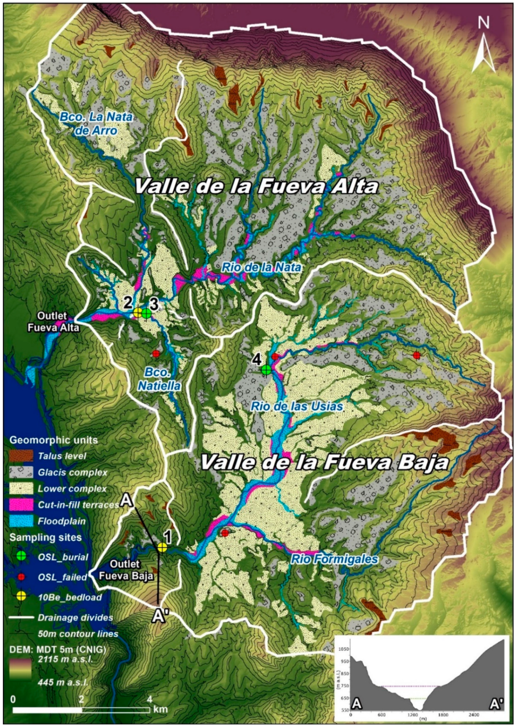
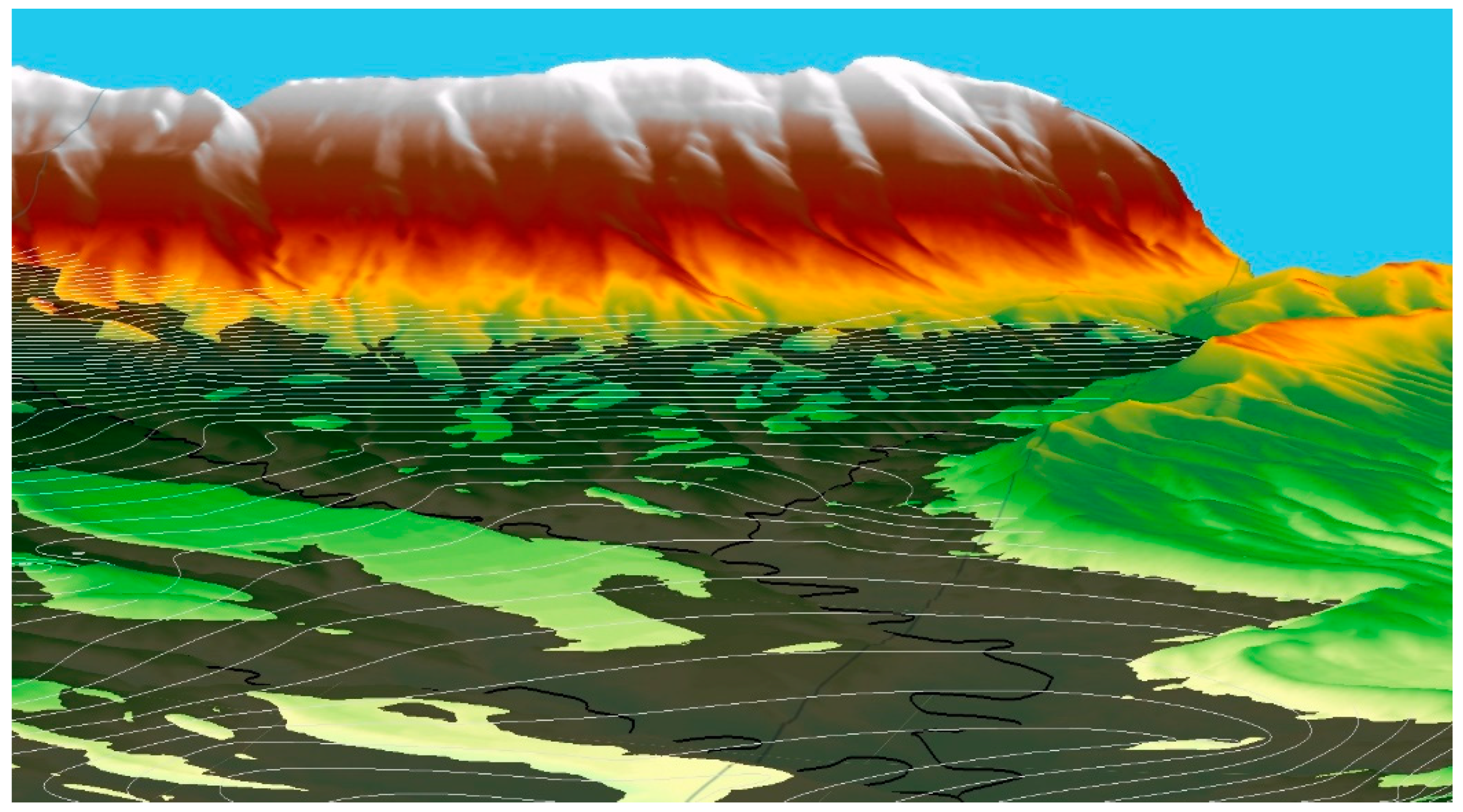
2. Settings
3. Methods
3.1. Digital Terrain Analysis
3.2. 10Be Catchment Erosion Rates
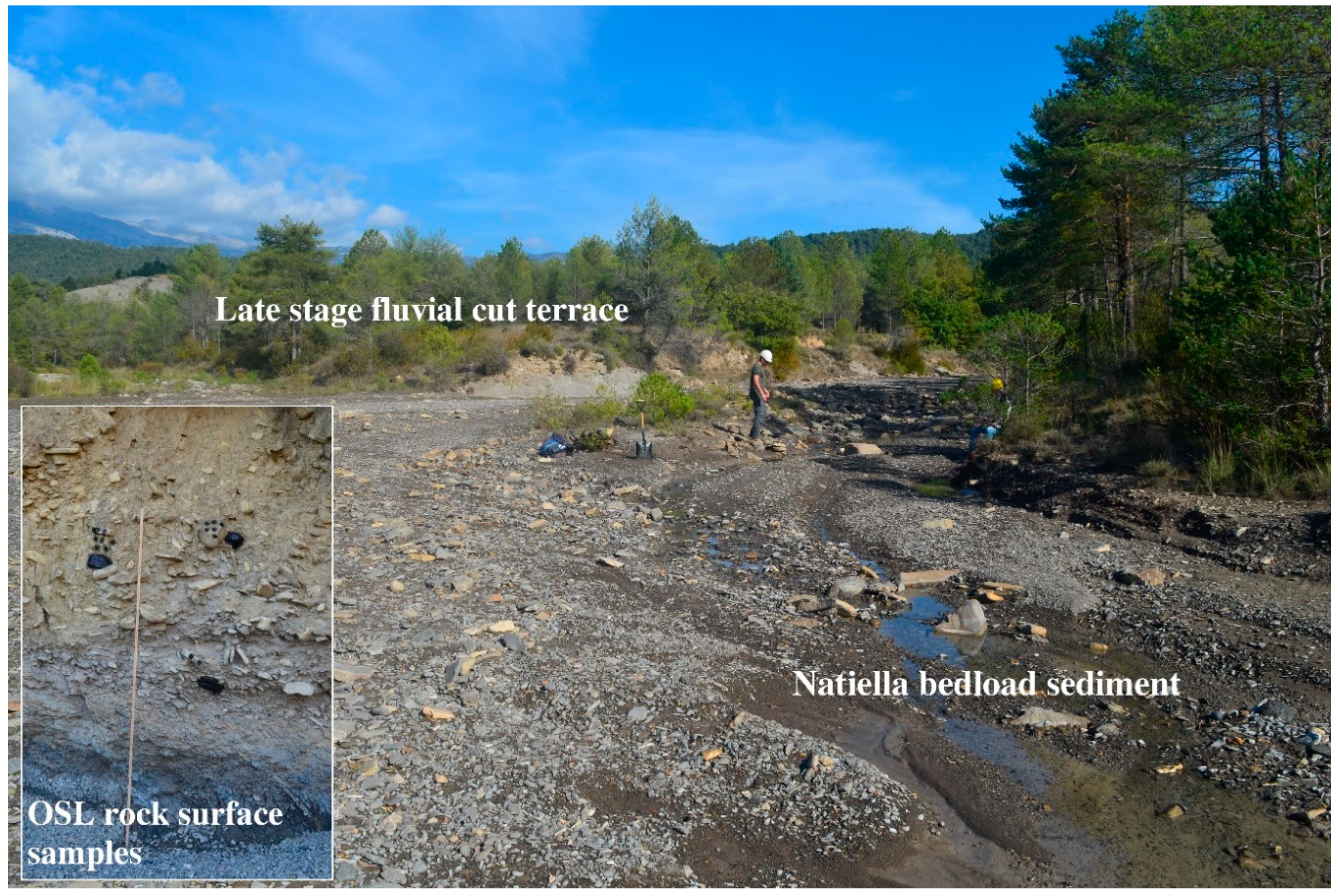
3.3. OSL Rock Surface Dating
4. Results
4.1. OSL Rock Surface Dating
4.2. TCN Catchment Erosion Rates
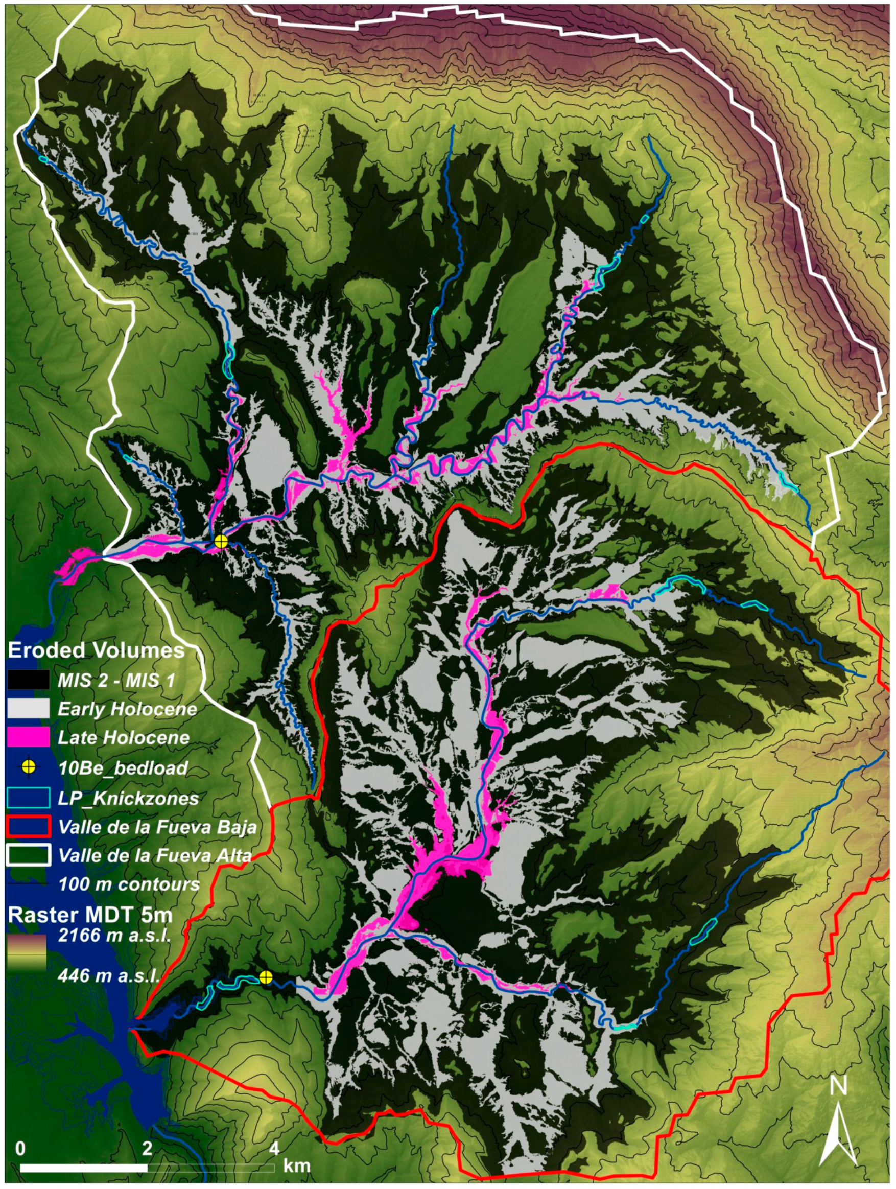
4.3. Eroded Sediment Volumes
5. Discussion
6. Conclusions
Author Contributions
Funding
Acknowledgments
Conflicts of Interest
References
- Vandenberghe, J. Timescales, climate and river development. Quat. Sci. Rev. 1995, 14, 631–638. [Google Scholar] [CrossRef]
- Vandenberghe, J. The relation between climate and river processes, landforms and deposits during the Quaternary. Quat. Int. 2002, 91, 17–23. [Google Scholar] [CrossRef]
- Maddy, D.; Bridgland, D.; Westaway, R. Uplift-driven valley incision and climate controlled river terrace development in the Thames Valley, UK. Quat. Int. 2001, 79, 23–36. [Google Scholar] [CrossRef]
- Tucker, G.E. Drainage basin sensitivity to tectonic and climatic forcing: Implications of a stochastic model for the role of entrainment and erosion thresholds. Earth Surf. Proc. Landf. 2004, 29, 185–205. [Google Scholar] [CrossRef]
- Merritts, D.J. Fluvial Environments | Terrace Sequences. In Encyclopedia of Quaternary Science; Elsevier: Amsterdam, The Netherlands, 2007; pp. 694–704. [Google Scholar]
- Bridgland, D.; Westaway, R. Climatically controlled river terrace staircases: A worldwide Quaternary phenomenon. Geomorphology 2008, 98, 285–315. [Google Scholar] [CrossRef] [Green Version]
- Garcia-Castellanos, D.; Vergés, J.; Gaspar-Escribano, J.; Cloetingh, S. Interplay between tectonics, climate and fluvial transport during the Cenozoic evolution of the Ebro Basin (NE Iberia). J. Geophys. Res. 2003, 108, 2347–2364. [Google Scholar] [CrossRef]
- Stange, K.M.; Van Balen, R.T.; Garcia-Castellanos, D. Numerical modelling of terrace staircase formation in the Quaternary drainage system of the southern Pyrenees, Ebro basin, NE Iberia. Basin Res. 2014, 28, 124–146. [Google Scholar] [CrossRef]
- Cordier, S.; Briant, B.; Bridgland, D.; Herget, J.; Maddy, D.; Mather, A.; Vandenberghe, J. The Fluvial Archives Group: 20 years of research connecting fluvial geomorphology and palaeoenvironments. Quat. Sci. Rev. 2017, 166, 1–9. [Google Scholar] [CrossRef] [Green Version]
- Cordier, S.; Adamson, K.; Delmas, M.; Calvet, M.; Harmand, D. Of ice and water: Quaternary fluvial response to glacial forcing. Quat. Sci. Rev. 2017, 166, 57–73. [Google Scholar] [CrossRef]
- Merritts, D.J.; Vincent, K.R.; Wohl, E.E. Long river profiles, tectonism, and eustasy: A guide to interpreting fluvial terraces. J. Geophys. Res. 1994, 99, 14031–14050. [Google Scholar]
- Cheetham, M.D.; Bush, R.T.; Keene, A.F.; Erskine, W.D. Nonsynchronous, episodic incision: Evidence of threshold exceedance and complex response as controls of terrace formation. Geomorphology 2010, 123, 320–329. [Google Scholar] [CrossRef]
- Temme, A.J.A.M.; Keiler, M.; Karssenberg, D.; Lang, A. Complexity and non-linearity in earth surface processes—Concepts, methods and applications. ESEX Commentary. Earth Surf. Proc. Landf. 2015, 40, 1270–1274. [Google Scholar] [CrossRef]
- Mather, A.E. Impact of headwater river capture on alluvial system development: An example from the Plio-Pleistocene of the Sorbas Basin, SE Spain. J. Geol. Soc. 2000, 157, 957–966. [Google Scholar] [CrossRef]
- Mather, A.E.; Stokes, M. Bedrock structural control on catchment-scale connectivity and alluvial fan processes, High Atlas Mountains, Morocco. In Geology and Geomorphology of Alluvial and Fluvial Fans: Terrestrial and Planetary Perspectives; Ventra, D., Clarke, L.E., Eds.; Geological Society Special Pub: London, UK, 2018; p. 440. [Google Scholar]
- López-Tarazón, J.A.; Batalla, R.J.; Vericat, D.; Francke, T. The sediment budget of a highly dynamic mesoscale catchment: The River Isábena. Geomorphology 2012, 138, 15–28. [Google Scholar] [CrossRef]
- Francke, T.; Werb, S.; Sommerer, E.; López-Tarazón, J.A. Analysis of runoff, sediment dynamics and sediment yield of subcatchments in the highly erodible Isábena catchment, Central Pyrenees. J. Soils Sediments 2014, 14, 1909–1920. [Google Scholar] [CrossRef]
- Stange, K.M.; Midtkandal, I.; Nystuen, J.P.; Kuss, H.-J.; Spiegel, C. Direct response of small non-glaciated headwater catchments to Late Quaternary climate change: The Valle de la Fueva, southern Pyrenees. Geomorphology 2018, 318, 187–202. [Google Scholar] [CrossRef]
- Lewis, C.J.; McDonald, E.V.; Sancho, C.; Peña, J.L.; Rhodes, E.J. Climatic implications of correlated upper Pleistocene glacial and fluvial deposits on the Cinca and Gállego Rivers (NE Spain) based on OSL dating and soil stratigraphy. Glob. Planet. Chang. 2009, 67, 141–152. [Google Scholar] [CrossRef]
- Calvet, M.; Delmas, M.; Gunnel, Y.; Braucher, R.; Bourlès, D. Recent advances in research on Quaternary glaciations in the Pyrenees. In Quaternary Glaciations, Extent and Chronology. Part IV: A Closer Look; Ehlers, J., Gibbard, P.L., Eds.; Elsevier: Amsterdam, The Netherlands, 2011; pp. 127–139. [Google Scholar]
- Hughes, P.D.; Gibbard, P.L.; Woodward, J.C. Quaternary glacial history of the Mediterranean Mountains. Prog. Phys. Geogr. 2006, 30, 334–364. [Google Scholar] [CrossRef]
- Woodward, J.C.; Hamlin, R.H.B.; Macklin, M.G.; Hughes, P.D.; Lewin, J. Glacial activity and catchment dynamics in northwest Greece: Longterm river behaviour and the slackwater sediment record for the last glacial to interglacial transition. Geomorphology 2008, 101, 44–67. [Google Scholar] [CrossRef]
- Wenzens, E.; Wenzens, G. The influence of tectonics, sea-level fluctuations and river capture on the Quaternary morphogenesis of the semi-arid Pulpi Basin (southeast Spain). Catena 1997, 30, 283–293. [Google Scholar] [CrossRef]
- Stokes, M.; Mather, A.E.; Belfoul, M.; Faik, F.; Bouzid, S.; Geach, M.R.; Cunha, P.P.; Bouton, S.J.; Thiel, C. Controls on dryland mountain landscape development along NW Saharan desert margins: Insights from Quaternary river terrace sequences (Dadès River, south-central High Atlas, Morocco). Quat. Sci. Rev. 2017, 166, 363–379. [Google Scholar] [CrossRef]
- Cloetingh, S.; Willet, S.D. TOPO-EUROPE: Understanding of the coupling between the deep Earth and continental topography. Tectonophysics 2013, 602, 1–14. [Google Scholar] [CrossRef]
- Braucher, R.; Blard, P.-H.; Benedetti, L.; Bourlès, D.L. Extending 10Be applications to carbonate-rich and mafic environments. In In Situ–Produced Cosmogenic Nuclides and Quantifi cation of Geological Processes; Siame, L., Bourlès, D.L., Brown, E.T., Eds.; Geological Society of America: Bolder, CO, USA, 2006; pp. 17–28. [Google Scholar] [CrossRef]
- Dunai, T.J. Cosmogenic nuclides. In Principles, Concepts and Applications in the Earth Surface Sciences; Cambridge University Press: Cambridge, UK, 2010. [Google Scholar]
- Portenga, E.W.; Bierman, P.R.; Duncan, C.; Corbett, L.B.; Kehrwald, N.M.; Hood, D.H. Erosion rates of the Bhutanese Himalaya determined using in situ-produced 10Be. Geomorphology 2015, 233, 112–126. [Google Scholar] [CrossRef]
- Murray, A.S.; Olley, J.M. Precision and accuracy in the optically stimulated luminescence dating of sedimentary quartz: a status review. Geochronometria 2002, 21, 1–16. [Google Scholar]
- Cordier, S. Optically stimulated luminescence dating: Procedures and applications to geomorphological research in France. Géomorphol. Relief Proc. Environ. 2010, 16, 21–40. [Google Scholar] [CrossRef]
- Sohbati, R.; Murray, A.S.; Porat, N.; Jain, M.; Avner, U. Age of a prehistoric “Rodedian” cult site constrained by sediment and rock surface luminescence dating techniques. Quat. Geochronol. 2015, 30, 90–99. [Google Scholar] [CrossRef] [Green Version]
- De Long, S.B.; Arnold, L.J. Dating alluvial deposits with optically stimulated luminescence, AMS 14C and cosmogenic techniques, western Transvers Ranges, California, USA. Quat. Geochronol. 2007, 2, 129–136. [Google Scholar] [CrossRef]
- Pallàs, R.; Rodés, A.; Braucher, R.; Bourlès, D.; Delmas, M.; Calvet, M.; Gunnel, Y. Small, isolated catchments as priority targets for cosmogenic surface exposure dating of Pleistocene climate fluctuations, south-eastern Pyrenees. Geology 2010, 38, 891–894. [Google Scholar] [CrossRef]
- Demoulin, A.; Mather, A.; Whittaker, A. Fluvial archives, a valuable record of vertical crustal deformation. Quat. Sci. Rev. 2016, 166, 10–37. [Google Scholar] [CrossRef]
- Puigdefábregas, C.; Muñoz, J.A.; Marzo, M. Thrust belt development in the eastern Pyrenees and related depositional sequences in the southern foreland basin. In Foreland Basins. International Association of Sedimentologists Series; Allen, P., Homewood, P., Eds.; Wiley: London, UK, 1986; pp. 229–246. [Google Scholar]
- Pickering, K.T.; Bayliss, N.J. Deconvolving tectono-climatic signals in deep-marine siliciclastics, Eocene Ainsa basin, Spanish Pyrenees: Seesaw tectonics versus eustasy. Geology 2009, 37, 203–206. [Google Scholar] [CrossRef]
- Michael, N.A.; Whittaker, A.C.; Carter, A.; Allen, P.A. Volumetric budget and grain-size fractionation of a geological sediment routing system: Eocene Escanilla Formation, South–Central Pyrenees. Geolog. Soc. Am. Bull. 2014, 126, 585–599. [Google Scholar] [CrossRef]
- Muñoz, J.A.; Arbués, P.; McClay, K.; Butillé, M. Structural Evolution of the Ainsa Deep Water Fold and Thrust Belt in the Central Pyrenees and Syn-Tectonic Evolution of the Related Sedimentary Systems; Society of Exploration Geophysicists: Tulsa, OK, USA, 2015. [Google Scholar]
- Muñoz, J.-A.; Beamud, E.; Fernández, O.; Arbués, P.; Dinarès-Turell, J.; Poblet, J. The Ainsa Fold and thrust oblique zone of the central Pyrenees: Kinematics of a curved contractional system from paleomagnetic and structural data. Tectonics 2013, 32, 1142–1175. [Google Scholar] [CrossRef] [Green Version]
- Peña, J.L. La Conca de Tremp y Sierras Prepirenaicas comprendidas entre los Ríos Segre y Noguera Ribagorzana: Estudio Geomorfologico; Instituto de Estudios ILerdenses Diputacion Provincial de Lerida: Lerida, Spain, 1983. [Google Scholar]
- Gosse, J.C.; Phillips, F.M. Terrestrial in situ cosmogenic nuclides: theory and application. Quat. Sci. Rev. 2001, 20, 1475–1560. [Google Scholar] [CrossRef] [Green Version]
- Balco, G.; Rovey, C.W. An isochron method for cosmogenic nuclide dating of buried soils and sediments. Am. J. Sci. 2008, 308, 1083–1114. [Google Scholar] [CrossRef]
- Lal, D. Cosmic ray labeling of erosion surfaces: In situ nuclide production rates and erosion models. Earth Planet. Sci. Lett. 1991, 104, 424–439. [Google Scholar] [CrossRef]
- Blanckenburg, F.V. The control mechanisms of erosion and weathering at basin scale from cosmogenic nuclides in river sediment. Earth Planet. Sci. Lett. 2005, 237, 462–479. [Google Scholar] [CrossRef]
- Ahnert, F. Functional relationships between denudation, relief, and uplift in large mid-latitude drainage basins. Am. J. Sci. 1970, 268, 243–263. [Google Scholar] [CrossRef]
- Brown, E.T.; Stallard, R.F.; Larsen, M.C.; Raisbeck, G.M.; Yiou, F. Denudation rates determined from the accumulation of in situ produced 10Be in the Luquillo Experimental forest, Puerto Rico. Earth Planet. Sci. Lett. 1995, 129, 193–202. [Google Scholar] [CrossRef]
- Granger, D.E.; Kirchner, J.W.; Finkel, R. Spatially averaged long-term erosion rates measured from in-situ produced cosmogenic nuclides in alluvial sediment. J. Geol. 1996, 104, 249–257. [Google Scholar] [CrossRef]
- Binnie, S.A.; Dunai, T.J.; Voronina, E.; Goral, T.S.; Dewald, A. Separation of Be and Al for AMS using single-step column chromatography. Nucl. Inst. Methods Phys. Res. B 2015, 361, 397–401. [Google Scholar] [CrossRef] [Green Version]
- Chmeleff, J.; Blanckenburg, F.; Kossert, K.; Jakob, D. Determination of the 10Be half-life by multicollector ICP-MS and liquid scintillation counting. Nucl. Instr. Meth. Phys. Res. Sect. B Beam Interact. Mater. Atoms 2010, 268, 192–199. [Google Scholar] [CrossRef]
- Korschinek, G.; Bergmaier, A.; Faestermann, T.; Gerstmann, U.C.; Knie, K.; Rugel, G.; Wallner, A.; Dillmann, I.; Dollinger, G.; Lierse Von Gostomski, C.; et al. A new value for the half-life of 10Be by heavy-ion elastic recoil detection and liquid scintillation counting. Nucl. Inst. Meth. Phys. Res. B 2010, 268, 187–191. [Google Scholar] [CrossRef]
- Stone, J.O. Air pressure and cosmogenic isotope production. J. Geophys. Res. 2000, 105, 23753–23759. [Google Scholar] [CrossRef] [Green Version]
- Balco, G.; Stone, J.O.; Lifton, N.A.; Dunai, T.J. A complete and easily accessible means of calculating surface exposure ages or erosion rates from 10Be and 26Al measurements. Quat. Geochronol. 2008, 3, 174–195. [Google Scholar] [CrossRef]
- Dehnert, A.; Schlüchter, C. Sediment burial dating using terrestrial cosmogenic nuclides. Quat. Sci. J. 2008, 57, 210–225. [Google Scholar]
- Sohbati, R. Luminescence, rock surfaces. In Encyclopedia of Scientific Dating Methods; Springer: Berlin, Germany, 2015; pp. 485–488. [Google Scholar]
- Murray, A.; Marten, R.; Johnston, A.; Martin, P. Analysis for naturally occuring radionuclides at environmental concentrations by gamma spectrometry. J. Radioanal. Nucl. Chem. 1987, 115, 263–288. [Google Scholar] [CrossRef]
- Murray, A.S.; Helsted, L.M.; Autzen, M.; Jain, M.; Buylaert, J.P. Measurement of natural radioactivity: Calibration and performance of a high-resolution gamma spectrometry facility. Radiat. Meas. 2018, 120, 215–220. [Google Scholar] [CrossRef]
- Bøtter-Jensen, L.; Thomsen, K.J.; Jain, M. Review of optically stimulated luminescence (OSL) instrumental developments for retrospective dosimetry. Radiat. Meas. 2010, 45, 253–257. [Google Scholar] [CrossRef]
- Guérin, G.; Mercier, N.; Adamiec, G. Dose-rate conversion factors: Update. Ancient TL 2011, 29, 5–8. [Google Scholar]
- Aitken, M.J.; Mejdahl, V. Thermoluminescence Dating; Academic Press: London, UK, 1985; p. 359. [Google Scholar]
- Prescott, J.R.; Hutton, J.T. Cosmic ray contributions to dose rates for luminescence and ESR dating: Large depths and long-term time variations. Radiat. Meas. 1994, 23, 497–500. [Google Scholar] [CrossRef]
- Murray, A.S.; Wintle, A.G. Luminescence dating of quartz using an improved single-aliquot regenerative-dose protocol. Radiat. Meas. 2000, 32, 57–73. [Google Scholar] [CrossRef]
- Wallinga, J.; Murray, A.; Wintle, A. The single-aliquot regenerative-dose (SAR) protocol applied to coarse-grain feldspar. Radiat. Meas. 2000, 32, 529–533. [Google Scholar] [CrossRef]
- Rades, E.F.; Sohbati, R.; Lüthgens, C.; Jain, M.; Murray, A.S. First luminescence-depth profiles from boulders from moraine deposits: Insights into glaciation chronology and transport dynamics in Malta valley, Austria. Radiat. Meas. 2018, 120, 281–289. [Google Scholar] [CrossRef]
- Sohbati, R.; Murray, A.; Buylaert, J.; Almeida, N.; Cunha, P.N.D. Optically stimulated luminescence (OSL) dating of quartzite cobbles from the Tapada do Montinho archaeological site (east-central Portugal). Boreas 2012, 41, 452–462. [Google Scholar] [CrossRef]
- Freiesleben, T.; Sohbati, R.; Murray, A.; Jain, M.; Khasawneh, S.; Hvidt, S.; Jakobsen, B. Mathematical model quantifies multiple daylight exposure and burial events for rock surfaces using luminescence dating. Radiat. Meas. 2015, 81, 16–22. [Google Scholar] [CrossRef]
- Bellin, N.; Vanacker, V.; Kubik, P.W. Denudation rates and tectonic geomorphology of the Spanish Betic Cordillera. Earth Plan. Sci. Lett. 2014, 390, 19–30. [Google Scholar] [CrossRef]
- Portenga, E.W.; Bierman, P. Understanding Earth’s eroding surface with 10Be. GSA Today 2011, 21, 8. [Google Scholar] [CrossRef]
- Jalut, G.; Montserrat Martí, J.; Fontugne, M.; Delibrias, G.; Vilaplana, J.M.; Julià, R. Glacial to interglacial vegetation changes in the northern and southern Pyrenees: Deglaciation, vegetation cover and chronology. Quat. Sci. Rev. 1992, 11, 449–480. [Google Scholar] [CrossRef]
- Suc, J.-P.; Popescu, S.-M. Pollen Records and Climatic Cycles in the North Mediterranean Region Since 2.7 Ma; Geology Society: London, UK, 2005; pp. 147–158. [Google Scholar]
- Gonzáles-Sampériz, P.; Aranbarri, J.; Pérez-Sanz, A.; Gil-Romera, G.; Moreno, A.; Leunda, M.; Gallejo, M.S.; Corella, J.P.; Morellon, M.; Oliva, B.; et al. Environmental and climate change in the southern Central Pyrenees since the last glacial maximum: A view from the lake records. Catena 2016, 149, 668–688. [Google Scholar] [CrossRef]
- Pérez-Sanz, A.; González-Sampériz, P.; Moreno, A.; Garces, V.B.; Romera, G.G.; Rieradevall, M.; Tarrats, P.; Alvarez, L.L.; Morellon, M.; Belmonte, A.; et al. Holocene climate variability, vegetation dynamics and fire regime in the central Pyrenees: The Basa de la Mora sequence (NE Spain). Quat. Sci. Rev. 2013, 73, 149–169. [Google Scholar] [CrossRef]
- Vannière, B.; Power, M.J.; Roberts, N.; Tinner, W.; Carrion, J.; Magny, M.; Bartlein, P.; Colombaroli, D.; Daniau, A.L.; Finsinger, W.; et al. Circum-Mediterranean fire activity and climate changes during the mid-Holocene environmental transition (8500-2500 cal. BP). Holocene 2011, 21, 53–73. [Google Scholar] [CrossRef]
- Benito, G.; Macklin, M.G.; Panin, A.; Machado, M.J.; Fontana, A.; Jones, F.A.; Machado, M.J.; Matlakhova, E.; Mozzi, P.; Zielhofer, C. Recurring flood distribution patterns related to short-term Holocene climatic variability. Nat. Sci. Rep. 2015, 5, 16398. [Google Scholar] [CrossRef] [Green Version]
- García-Ruiz, J.M.; Sanjuán, Y.; Gil-Romera, G.; Samperiz, G.P.; Begueria, S.; Arnaez, J.; Perez, C.A.; Villar, A.G.; Martinez, J.A.; Renault, L.N.; et al. Mid and late Holocene forest fires and deforestation in the subalpine belt of the Iberian range, northern Spain. J. Mount. Sci. 2016, 13, 1760–1772. [Google Scholar] [CrossRef] [Green Version]
- Molliex, S.; Rabineau, M.; Leroux, E.; Bourlès, D.L.; Authemayou, C.; Aslanian, D.; Chavet, F.; Civet, F.; Jouët, G. Multi-approach quantification of denudation rates in the Gulf of Lion source-to-sink system (SE France). Earth Plan. Sci. Lett. 2016, 444, 101–115. [Google Scholar] [CrossRef]


| Sample ID | Sampling Site | Catchment | Mean Latitude [dec. deg.] | Mean Longitude [dec. deg.] | Mean Elevation [m a.s.l.] |
|---|---|---|---|---|---|
| S-45 | 2408/2409 | Fueva Baja | 42.36124 | 0.27722 | 805 |
| S-48 | 3303 | Natiella | 42.38569 | 0.23082 | 714 |
| Step | Treatment | Measurement |
|---|---|---|
| 1 | Give regenerative dose, Di | - |
| 2 | Preheat to 250 °C for 100 s | - |
| 3 | Stimulate at 50 °C with IR for 200 s | Li |
| 4 | Give fixed test dose, DT | - |
| 5 | Preheat to 250 °C for 100 s | - |
| 6 | Stimulate at 50 °C with IR for 200 s | Ti |
| 7 | Stimulate at 290 °C for 200 s | - |
| 8 | Return to step 1 | - |
| Sample Code | 238U Bq/kg | 226Ra Bq/kg | 232Th Bq/kg | 40K Bq/kg | β Dose Rate, Gy/ka | γ Dose Rate, Gy/ka |
|---|---|---|---|---|---|---|
| 3304-02 | 10 ± 1 | 11.9 ± 0.2 | 12.28 ± 0.16 | 84 ± 2 | 0.430 ± 0.010 | 0.314 ± 0.010 |
| 3304-06 | 19 ± 1 | 19.3 ± 0.2 | 5.57 ± 0.13 | 52 ± 2 | 0.387 ± 0.014 | 0.273 ± 0.016 |
| 3305-05 | 4 ± 3 | 7.3 ± 0.3 | 7.3 ± 0.3 | 180 ± 6 | 0.586 ± 0.016 | 0.291 ± 0.009 |
| Sed 4 | 22 ± 5 | 20.9 ± 0.4 | 25.1 ± 0.5 | 373 ± 9 | 1.319 ± 0.027 | 0.735 ± 0.020 |
| Sed 5 | 14 ± 4 | 17.6 ± 0.3 | 18.4 ± 0.3 | 221 ± 6 | 0.858 ± 0.019 | 0.514 ± 0.016 |
| Sample Code | Depth [cm] | Dose [Gy] | n * | Apparent Age [ka] | Dose Rate ** [Gy/ka] | Age Correction Factor *** | Corrected Age [ka] |
|---|---|---|---|---|---|---|---|
| 3304-02 top | 275 | 6.2 ± 0.3 | 12 | 2.8 ± 0.2 | 2.24 ± 0.08 | 0.75 | 3.7 ± 0.2 |
| 3304-02 bottom | 275 | 7.4 ± 0.3 | 10 | 3.3 ± 0.2 | 2.24 ± 0.08 | 0.82 | 4 ± 0.2 |
| 3304-06 top | 275 | 5.8 ± 0.3 | 6 | 2.4 ± 0.2 | 2.44 ± 0.09 | 0.89 | 2.6 ± 0.2 |
| 3304-06 side | 275 | 34 ± 9 | 3 | 14 ± 4 | 2.44 ± 0.09 | 0.87 | 16 ± 4 |
| 3305-05 top | 275 | 164 ± 11 | 14 | 74 ± 6 | 2.22 ± 0.08 | 0.75 | 96 ± 7 |
| Sample ID | Qtz. Mass Dissolved [g] | Mass 9Be Carrier [g] | 10Be/9Be | Conc. 10Be [at g−1] | Uncert. 10Be [at g−1] | Erosion Rate [g cm−2 yr−1] | Erosion Rate [mm kyr−1] | Uncert. [mm kyr−1] |
|---|---|---|---|---|---|---|---|---|
| S-45 | 11.8056 | 3.022 × 10⁻⁴ | 6.975 × 10⁻¹⁴ | 116,762.7 | 5044.15 | 0.00947 | 47.35 | 4.42 |
| S-48 | 8.9154 | 3.022 × 10⁻⁴ | 2.744 × 10⁻¹⁴ | 59,118.64 | 3440.70 | 0.01920 | 96.02 | 9.79 |
© 2019 by the authors. Licensee MDPI, Basel, Switzerland. This article is an open access article distributed under the terms and conditions of the Creative Commons Attribution (CC BY) license (http://creativecommons.org/licenses/by/4.0/).
Share and Cite
Stange, K.M.; Midtkandal, I.; Nystuen, J.P.; Murray, A.; Sohbati, R.; Thompson, W.; Spiegel, C.; Kuss, H.-J. Erosive Response of Non-Glaciated Pyrenean Headwater Catchments to the Last Major Climate Transition and Establishing Interglacial Conditions. Quaternary 2019, 2, 17. https://0-doi-org.brum.beds.ac.uk/10.3390/quat2020017
Stange KM, Midtkandal I, Nystuen JP, Murray A, Sohbati R, Thompson W, Spiegel C, Kuss H-J. Erosive Response of Non-Glaciated Pyrenean Headwater Catchments to the Last Major Climate Transition and Establishing Interglacial Conditions. Quaternary. 2019; 2(2):17. https://0-doi-org.brum.beds.ac.uk/10.3390/quat2020017
Chicago/Turabian StyleStange, Kurt Martin, Ivar Midtkandal, Johan Petter Nystuen, Andrew Murray, Reza Sohbati, Warren Thompson, Cornelia Spiegel, and Hans-Joachim Kuss. 2019. "Erosive Response of Non-Glaciated Pyrenean Headwater Catchments to the Last Major Climate Transition and Establishing Interglacial Conditions" Quaternary 2, no. 2: 17. https://0-doi-org.brum.beds.ac.uk/10.3390/quat2020017