Natural and Geomorphological Response of the Small Lowland River Valley for Anthropogenic Transformation


Abstract
:1. Introduction
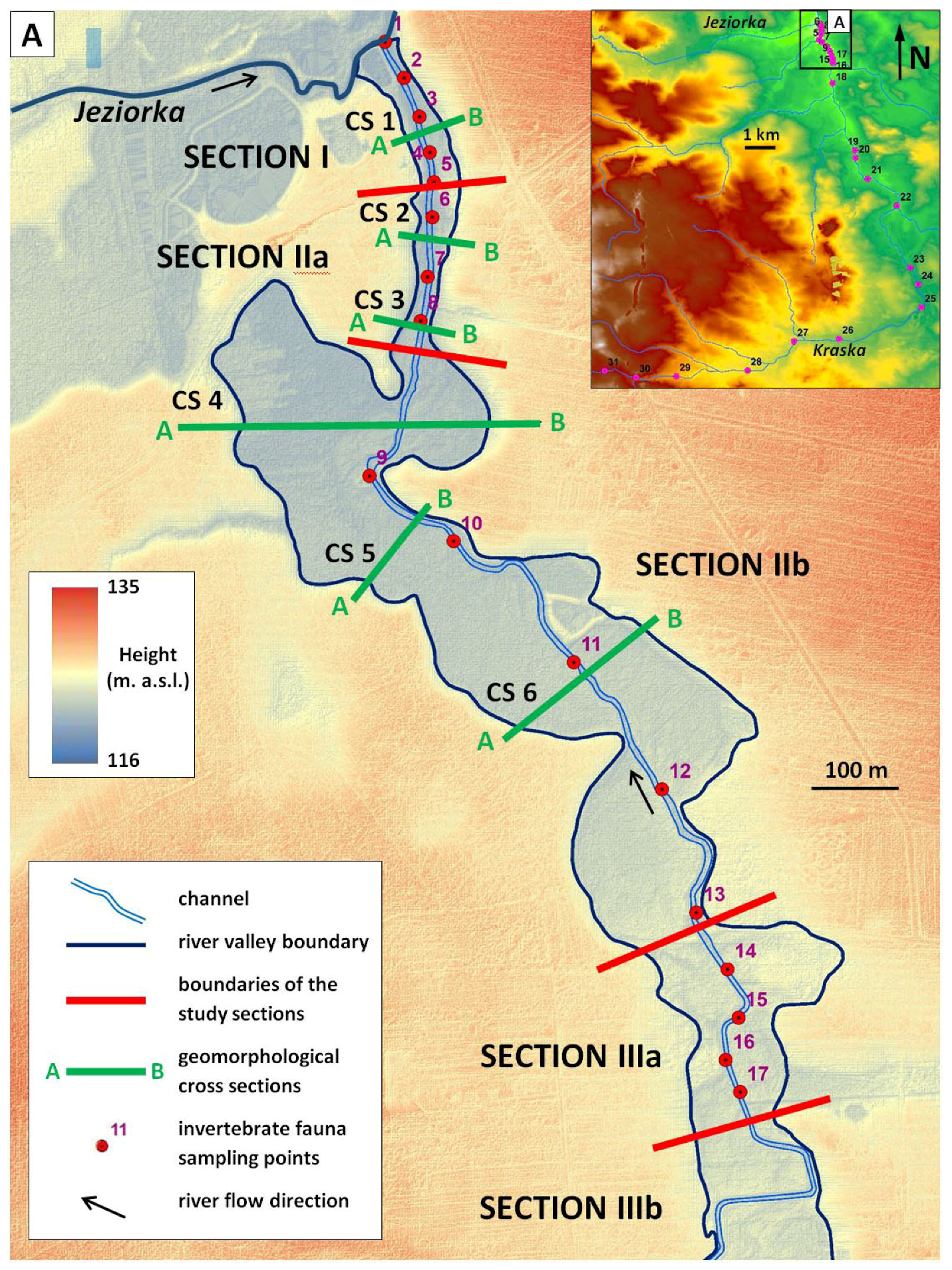
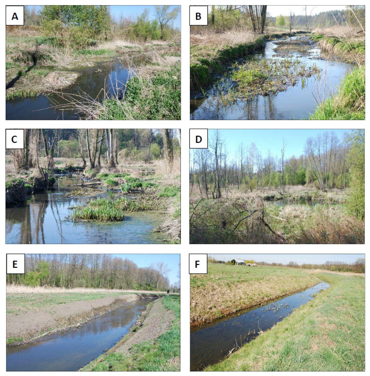
2. Study Area
3. Methods
3.1. Division of the Valley into Research Sections
3.2. Studies on Invertebrate Riverbed Fauna
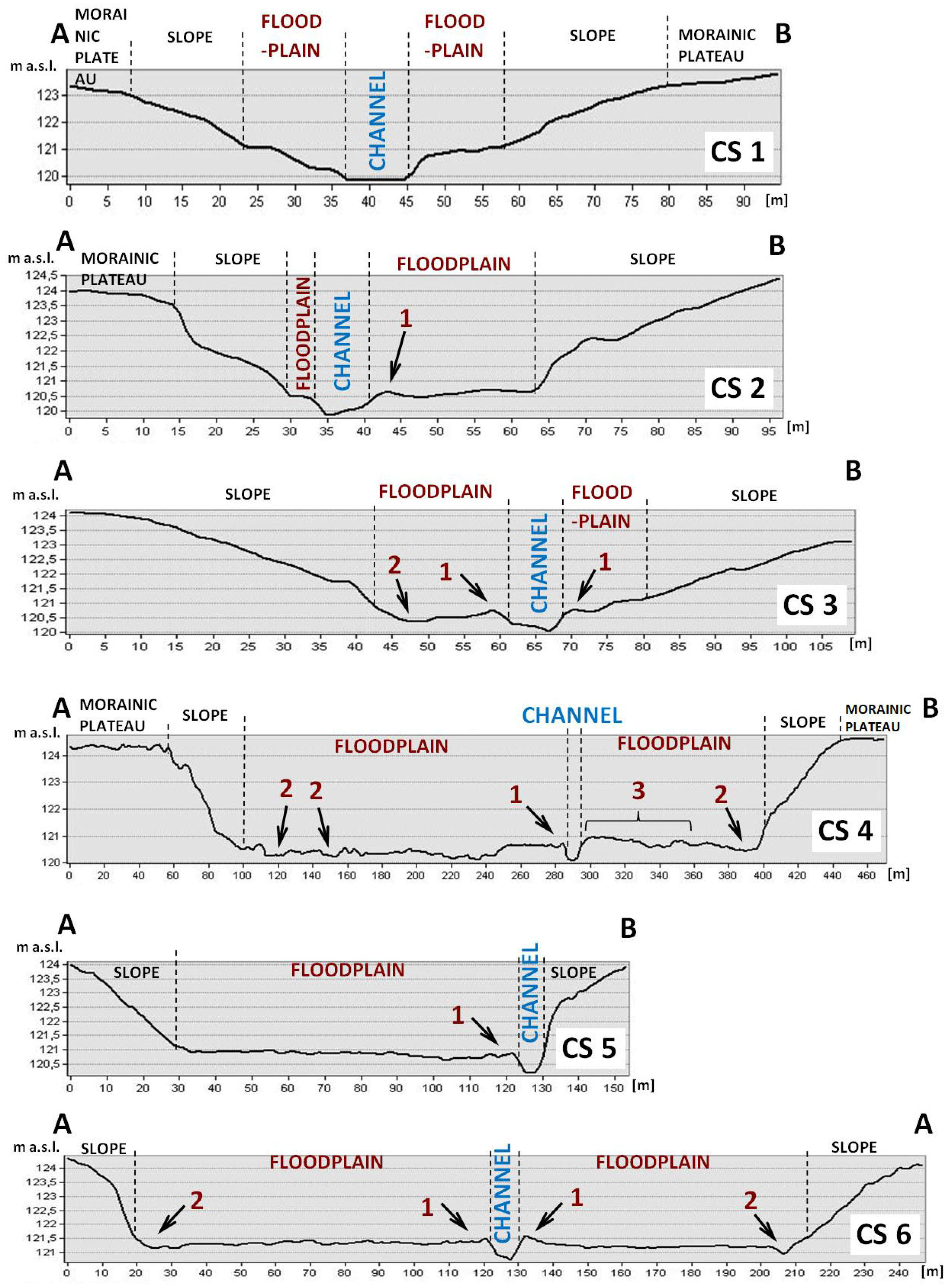
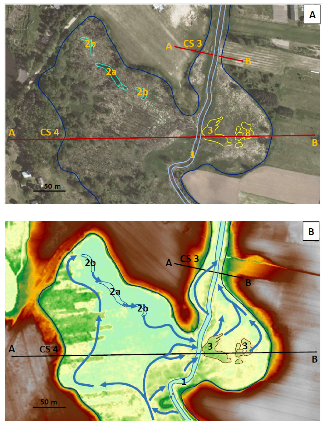
3.3. Analysis of the River Valley Bottom Relief
4. Results
4.1. The Valley Floor Relief
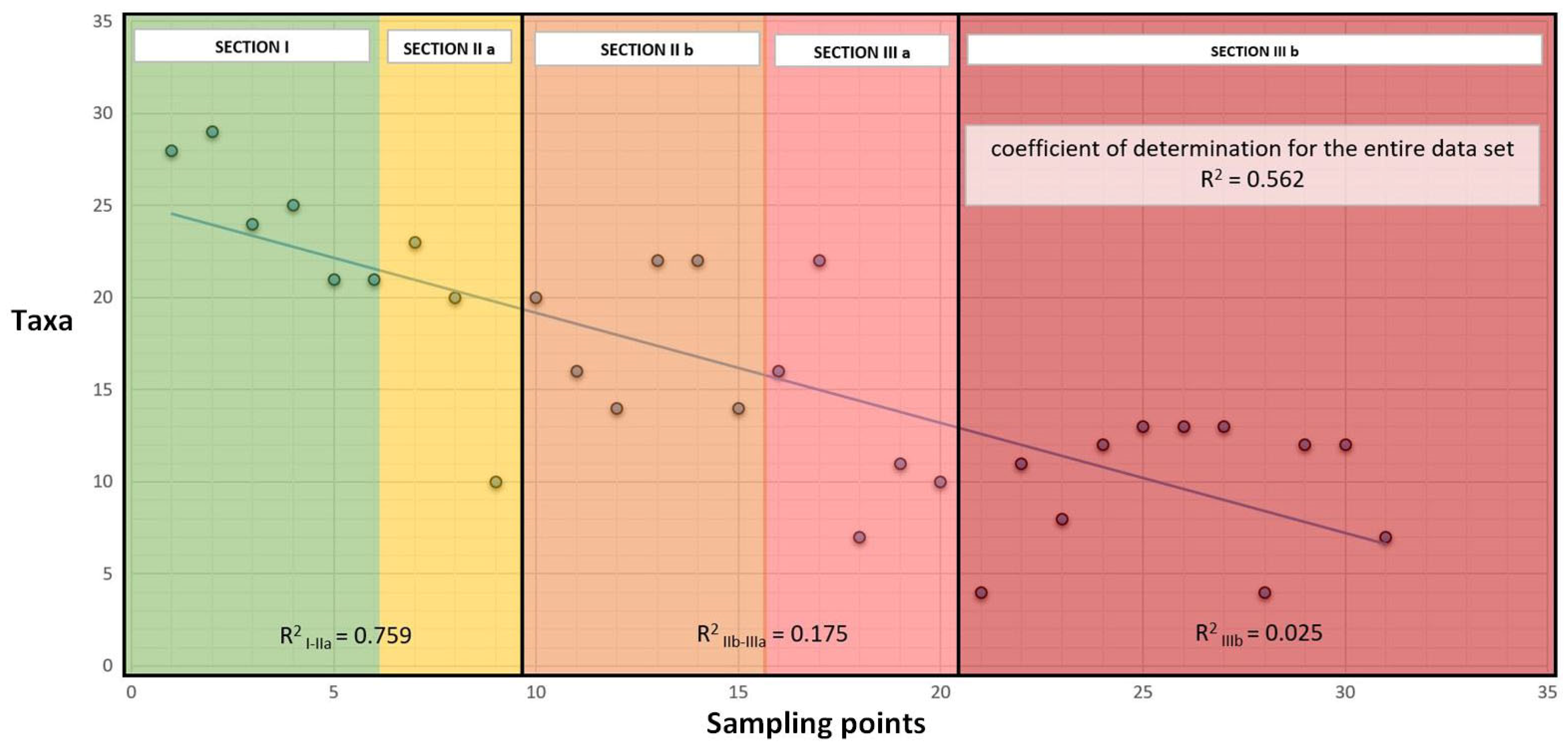
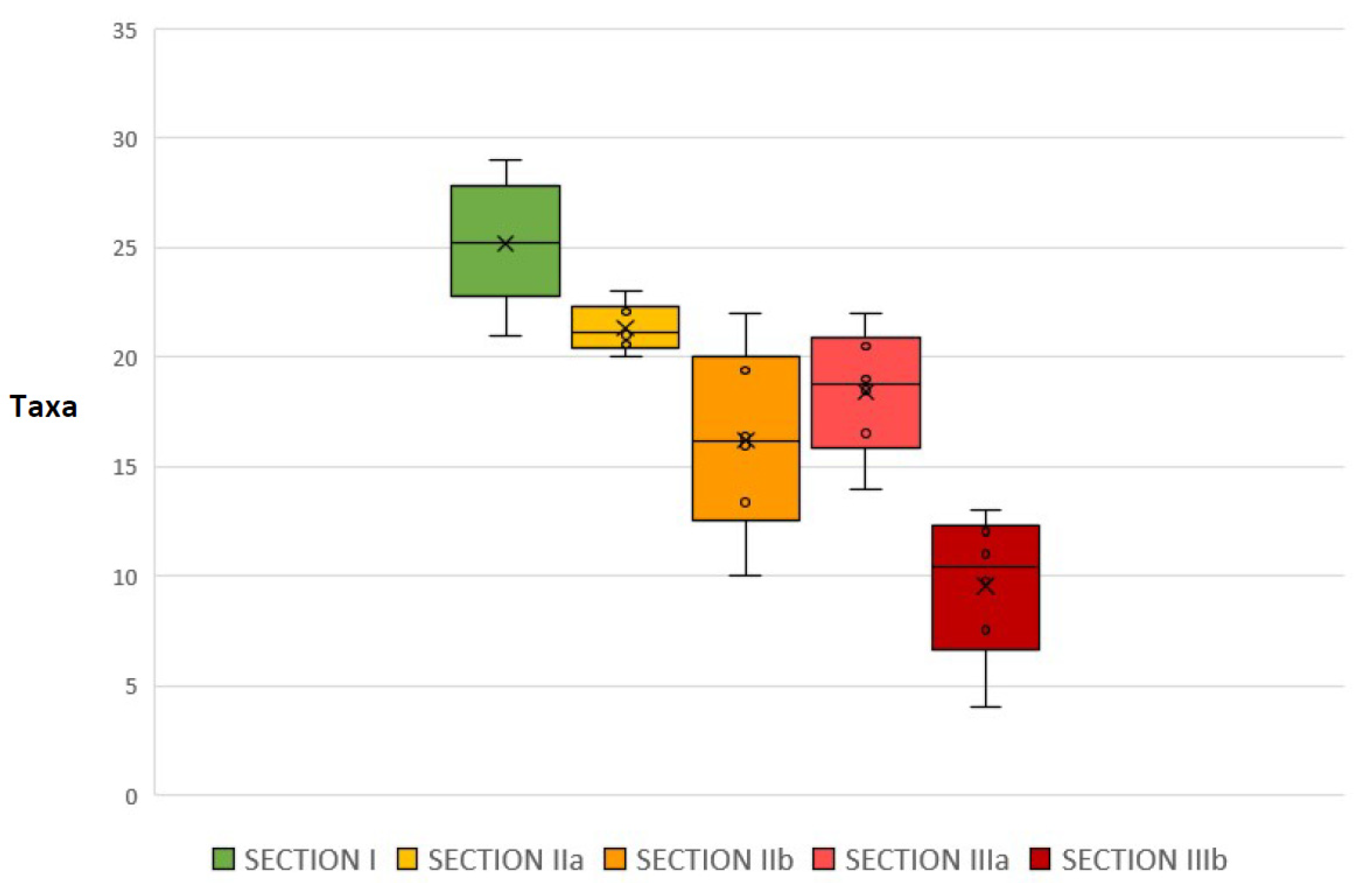
4.2. The Invertebrate Fauna of the Riverbed
5. Discussion
6. Conclusions
- In the regulated sections of Kraska, natural forms of relief in the channel zone and the proximal part of the floodplain were destroyed, which caused the destruction of most of the habitats. The samplings of protozoan and invertebrate fauna confirmed that these sections significantly reduced their biological diversity. The regulation not only significantly worsened the ecological condition of the river but made it practically impossible for it to act as a corridor for free migration.
- The results of the investigations gained in some sections of the river showed the ability for spontaneous self-recovery of the aquatic ecosystem about 18 years from the completion of the regulatory work. The reason for this is probably the cyclical congestion characteristic of the Polish Lowland rivers and the associated long-lasting extra-corridor flows.
- The studies of the Kraska River point out the mass regulation of small watercourses in the Central European Lowlands that may lead to drastic biological impoverishment of these areas.
- The analysis of relief changes in the Kraska River valley indicates that the regulation of small watercourses, especially in the case of less expensive technologies, is not able to counteract the natural morphodynamics of the valley floor. This makes costly maintenance work necessary. This factor should be taken into account when assessing the advisability of carrying out the river regulation and planning of maintenance works, versus possible, wise restoration and management of aquatic ecosystems.
Author Contributions
Funding
Acknowledgments
Conflicts of Interest
References
- Council of the European Communities. Directive 2000/60/EC of the European Parliament and of the Council of 23 October 2000 establishing a framework for Community action in the field of water policy. Off. J. 2000, 327, 1–72. [Google Scholar]
- Rinaldo, A.; Gatto, M.; Rodriguez-Iturbe, I. River networks as ecological corridors: A coherent ecohydrological perspective. Adv. Water Resour. 2018, 112, 27–58. [Google Scholar] [CrossRef]
- Beisel, J.N.; Usseglio-Polatera, P.; Thomas, P.S.; Moreteau, J.-C. Stream community structure in relation to spatial variation: The influence of mesohabitat characteristics. Hydrobiologia 1998, 389, 73–88. [Google Scholar] [CrossRef]
- Sender, J.; Maślanka, W. Natural Values of the Urban River Valley and the Possibilities of its Development – Bystrzyca River Valley Study Case (Poland). J. Lucian Braga Univ. Sibiu 2018, 20, 85–102. [Google Scholar] [CrossRef] [Green Version]
- Callow, P.; Petts, G. The Rivers Handobook; Blackwell Scientific Publications: Oxford, UK, 1992; Volume 1. [Google Scholar]
- Paisley, M.F.; Walley, W.J.; Trigg, D.J. Identification of macro-invertebrate taxa as indicators of nutrient enrichment in rivers. Ecol. Inform. 2011, 6, 399–406. [Google Scholar] [CrossRef]
- Bączyk, A.; Wagner, M.; Okruszko, T.; Grygoruk, M. Influence of technical maintenance measures on ecological status of agricultural lowland rivers—Systematic review and implications for the river management. Sci. Total Environ. 2018, 627, 189–199. [Google Scholar] [CrossRef]
- Hachol, J.; Hämmerling, M.; Bondar-Nowakowska, E. Applying the Analytical Hierarchy Process (AHP) into the effects assessment of river training works. J. Water Land Dev. 2017, 35. [Google Scholar] [CrossRef] [Green Version]
- Hachol, J.; Bodnar-Nowakowska, E.; Hachaj, P.S. Application of Game Theory against Nature in the Assessment of Technical Solutions Used in River Regulation in the Context of Aquatic Plant Protection. Sustainability 2019, 11, 1260. [Google Scholar] [CrossRef] [Green Version]
- Beisel, J.N.; Usseglio-Polatera, P.; Moreteau, J.C. The spatial heterogeneity of a river bottom: A key factor determining macroinvertebrate communities. Hydrobiologia 2000, 422, 163–171. [Google Scholar] [CrossRef]
- Florek, W.; Zwoliński, Z.; Andrzejewski, L.; Kostrzewski, A.; Smolska, E.; Szmańda, J. Współczesne procesy kształtujące rzeźbę dolin rzecznych. In Współczesne Przemiany Rzeźby Polski; Starkel, L., Kostrzewski, A., Kotarba, A., Krzemień, K., Eds.; IGiGP UJ: Kraków, Poland, 2008; pp. 292–305. [Google Scholar]
- Falkowski, T.; Ostrowski, P. Relief of the Pilica river valley between Inowłódz and Domaniewice and its relationship with the geological structure of alluvia basement. In Infrastruktura i Ekologia Terenów Wiejskich; Polska Akademia Nauk: Kraków, Poland, 2010; pp. 53–63. [Google Scholar]
- Ostrowski, P.; Utratna, M. The hydrological conditions of the morphogenesis in relation to the selected erosional landforms on the floodplain of the Bug river valley. Sci. Rev.–Eng. Environ. Sci. 2018, 27, 57–70. [Google Scholar] [CrossRef] [Green Version]
- Ostrowski, P.; Falkowski, T.; Utratna-Żukowska, M. The Effect of Geological Channel Structures on Floodplain Morphodynamics of Lowland Rivers: A Case Study from the Bug River, Poland. CATENA 2021, 202, 105209, ISSN 0341-8162. [Google Scholar] [CrossRef]
- Cogerino, L.; Cellot, B.; Bournard, M. Microhabitat diversity and associated macroinvertebrates in aquatic banks of a large European river. Hydrobiologia 1995, 304, 103–115. [Google Scholar] [CrossRef]
- Oglęcki, P.; Pachuta, K. The effect of chosen riverbed parameters on different biological elements of lowland Wkra River Eco-systems. Ann. Wars. Agric. Univ.—SGGW. Land Reclam. 2005, 36, 47–53. [Google Scholar]
- Verdonschot, P.F.M.; Nijboer, R.C. Testing the European stream typology of the Water Framework Directive for macroinvertebrates. Hydrobiologia 2004, 516, 35–54. [Google Scholar] [CrossRef]
- Naiman, R.J.; Rogers, K.H. Large animals and system-level characteristics in river corridors. BioScience 1997, 47, 521–529. [Google Scholar] [CrossRef] [Green Version]
- Rodriguez-Iturbe, I.; Muneepeerakul, R.; Bertuzzo, E.; Levin, S.; Rinaldo, A. River networks as ecological corridors: A complex systems perspective for integrating hydrologic, geomorphologic, and ecologic dynamics. Water Resour. Res. 2009, 45, 1–22. [Google Scholar] [CrossRef]
- Andrzejewski, L.; Krzemień, K.; Zwoliński, Z. Zarys przyrodniczych i antropogenicznych uwarunkowań rozwoju systemów dolinnych i korytowych w Polsce. Landf. Anal. 2018, 37, 17–51. [Google Scholar] [CrossRef]
- Kaszowski, L.; Krzemień, K. Classification systems of mountain river channels. In River Channels Pattern, Structure and Dynamics; Krzemień, K., Ed.; Prace Geograficzne Instytutu Geografii UJ; IGiGP UJ: Kraków, Poland, 1999; Volume 104, pp. 27–40. [Google Scholar]
- Falkowski, T.; Ostrowski, P.; Bogucki, M.; Karczmarz, D. The trends in the main thalweg path of selected reaches of the Middle Vistula River, and their relationships to the geological structure of river channel zone. Open Geosci. 2018, 10, 554–564. [Google Scholar] [CrossRef]
- Larsen, S.; Ormerod, S.J. Combined effects of habitat modification on trait composition and species nestedness in river invertebrates. Biol. Conserv. 2010, 143, 2638–2646. [Google Scholar] [CrossRef]
- Romanowski, J.; Matuszkiewicz, J.; Kowalczyk, K.; Kowalska, A.; Kozłowska, A.; Solon, J.M.; Middendorp, H.; Reijnen, R.; Rozemeijer, R.; van der Slums, T. Evaluation of Ecological Consequences of Development Scenarios for the Vistula River Valley; Vistula Econet Development and Implementation VEDI: Warszawa/Wageningen/Utrecht, Poland, 2005. [Google Scholar]
- Plit, J. Zarządzanie krajobrazem dolin rzecznych. In Zarządzanie Krajobrazem Kulturowym; Prace Komisji Krajobrazu Kulturowego Nr 10, 230–240; Komisja Krajobrazu Kulturowego PTG: Sosnowiec, Poland, 2008. [Google Scholar]
- Żelazo, J.; Popek, Z. Podstawy Renaturyzacji Rzek; SGGW: Warszawa, Poland, 2002. [Google Scholar]
- Szałkiewicz, E.; Sucholas, J.; Grygoruk, M. Feeding the Future with the Past: Incorporating Local Ecological Knowledge in River Restoration. Resources 2020, 9, 47. [Google Scholar] [CrossRef]
- Gacka–Grzesikiewicz, E.; Cichocki, Z. The Programme of the River Valleys Protection in Poland; The Institute of Environmental Protection: Warsaw, Poland, 2001. [Google Scholar]
- Orłow-Gozdowska, Ł. Program for the Protection and Development of Water Resources in the Mazowieckie Voivodeship in the Field of Rivers Improvement for Bi-Environmental Fish—Project; Department of Agriculture and Modernization of Rural Areas Office of the Marshal of the Mazowieckie Voivodeship: Warsaw, Poland, 2005. [Google Scholar]
- Jagiełło, J. The Jeziorka River, the Świder River, the Wilga River, the Okrzejka River and their Tributaries; Wydawnictwo Ciekawe Miejsca: Warsaw, Poland, 2014. [Google Scholar]
- McCafferty, W.P. Aquatic Entomology: The Fisherman’s and Ecologist’s Illustrated Guide to Insects; Jones and Bartlett Publishers: Boston, MA, USA, 1983; p. 448. [Google Scholar]
- Kołodziejczyk, A.; Koperski, P. Bezkregowce Słodkowodne Polski. Klucz do oznaczania oraz podstawy biologii i ekologii. In Freshwater Invertebrates in Poland: Key to the Identification and Principles of Biology and Ecology; Warsaw University Press: Warsaw, Poland, 2000. [Google Scholar]
- Ostrowski, P.; Falkowski, T. Application of Remote Sensing Methods to Study the Relief of Lowland River Valleys with a Complex Geological Structure—A Case Study of the Bug River. Water 2020, 12, 487. [Google Scholar] [CrossRef] [Green Version]
- Bujakowski, F.; Falkowski, T.; Podlasek, A. Geomorphological immaturity as a factorconditioning the dynamics of channel processes in Rządza River. Open Geosci. 2021, 27–38. [Google Scholar] [CrossRef]
- National Geo-Portal. Digital Terrain Model, Information Layer Hypsometry (WMS). Available online: https://mapy.geoportal.gov.pl/imap/Imgp_2.html?locale=pl&gui=new&sessionID=566557 (accessed on 20 May 2021).
- Oglęcki, P. Invertebrate and fish environment al preferences as the key factor for lowland riverbed biodiversity. Ann. Wars. Univ. Life Sci.-SGGW Land Reclam. 2008, 40, 125–130. [Google Scholar] [CrossRef]
- Aczel, A.D.; Sounderpandian, J. Complete Business Statistics, 2nd ed.; Wydawnictwo Naukowe PWN: Warsaw, Poland, 2018. [Google Scholar]
- Sheldon, F.; Boulton, A.J.; Puckridge, J.T. Conservation value of variable connectivity: Aquatic invertebrate assemblages of channel and floodplain habitats of a central Australian arid-zone river, Cooper Creek. Biol. Conserv. 2002, 103, 13–31. [Google Scholar] [CrossRef]
- Cairns, J.; Pratt, J.R. A History of Biological Monitoring Using Benthic Macroinvertebrates. In Freshwater Biomonitoring and Benthic Macroinvertebrates; Rosenberg, D.M., Resh, V.H., Eds.; Chapman and Hall: New York, NY, USA, 1993. [Google Scholar]
- Almeida, D.; Merino-Aguirre, R.; Angeler, D.G. Benthic invertebrate communities in regulated Mediterranean streams and least-impacted tributaries. Limnol.—Ecol. Manag. Inland Waters 2013, 43, 34–42. [Google Scholar] [CrossRef]
- Strayer, D.L.; Dudgeon, D. Freshwater biodiversity conservation: Recent progress and future challenges. J. N. Am. Benthol. Soc. 2010, 29, 344–358. [Google Scholar] [CrossRef] [Green Version]
- Bunn, S.E.; Arthington, A.H. Basic Principles and Ecological Consequences of Altered Flow Regimes for Aquatic Biodiversity. Environ. Manag. 2002, 30, 492–507. [Google Scholar] [CrossRef] [Green Version]
- Finlayson, C.M. Wetland management and restoration: Summary. In Proc. Workshop: Wetland Management and Restoration; Finlayson, C.M., Larsson, T., Eds.; Report 3992; Swedish Environ. Protection Agency: Stockholm, Sweden, 1991; pp. 174–179. [Google Scholar]
- Brookes, A. Channelized Rivers: Perspectives for Environmental Management; John Wiley & Sons, Chichester: Hoboken, NJ, USA, 1988. [Google Scholar]
- Zwoliński, Z. Sedimentology and geomorphology of overbank flows on meandering river floodplains. Geomorphology 1992, 4, 367–379. [Google Scholar] [CrossRef]
- Wierzbicki, G.; Ostrowski, P.; Mazgajski, M.; Bujakowski, F. Using VHR multispectral remote sensing and LIDAR data to determine the geomorphological effects of overbank flow on a floodplain (the Vistula River, Poland). Geomorphology 2013, 183, 73–81. [Google Scholar] [CrossRef]
- Wierzbicki, G.; Ostrowski, P.; Falkowski, T.; Mazgajski, M. Geological setting control of flood dynamics in lowland rivers. Sci. Total Environ. 2018, 636, 367–382. [Google Scholar] [CrossRef]
- Wierzbicki, G.; Ostrowski, P.; Falkowski, T. Applying floodplain geomorphology and flood management in the Lower Vistula River upstream from Plock. Open Geosci. 2020, 12, 1003–1016, ISSN 2391-5447. [Google Scholar] [CrossRef]


| Sections | The Length (km) | The Section Characteristics | The Scope of Conservation Works | The Amount/Number of the Invertebrate Sampling Points |
|---|---|---|---|---|
| I | 0.2 | close to natural; narrow floodplain approximately 40 m wide; large number of natural elements in the channel zone | unregulated | 5/1–5 |
| IIa | 0.2 | transitional; narrow floodplain zone approximately 40 m wide; large number of natural elements in the channel zone | regulated in the years 2002/2003 | 3/6–8 |
| IIb | 0.9 | transitional; wide floodplain zone up to 300 m wide with traces of meandering (paleomeanders, oxbow lakes) | 4/10–13 | |
| IIIa | 0.2 | channelized; floodplain zone up to 200 m wide; the channel with few natural elements | regulated in the years 2014–2019 | 4/14–17 |
| IIIb | 27.3 | completely channelized, without any natural structures, the only elements differentiating the channel are of anthropogenic origin | 14/18–31 |
| Taxa | Section I | Section II A | Section IIb | Section IIIa | Section IIIb | ||||||||||||||||||||||||||
|---|---|---|---|---|---|---|---|---|---|---|---|---|---|---|---|---|---|---|---|---|---|---|---|---|---|---|---|---|---|---|---|
| 1 | 2 | 3 | 4 | 5 | 6 | 7 | 8 | 9 | 10 | 11 | 12 | 13 | 14 | 15 | 16 | 17 | 18 | 19 | 20 | 21 | 22 | 23 | 24 | 25 | 26 | 27 | 28 | 29 | 30 | 31 | |
| Protozoa Amoeba proteus | + | + | + | + | + | + | + | + | + | + | + | + | + | + | + | + | + | + | + | + | + | + | + | + | + | + | + | + | + | + | + |
| Codonella cratera | + | + | |||||||||||||||||||||||||||||
| Stentor sp. | + | + | + | + | + | + | + | + | + | + | |||||||||||||||||||||
| Spongiaria Euspongilla lacustris | + | + | + | + | + | + | + | + | |||||||||||||||||||||||
| Ephydatia fluviatilis | + | + | + | + | |||||||||||||||||||||||||||
| Hydrozoa Hydra sp. | + | + | + | + | + | + | + | + | + | + | + | + | + | + | + | + | + | + | + | + | + | ||||||||||
| Turbellaria Dendrocoelum lacteum | + | + | + | + | + | ||||||||||||||||||||||||||
| Dugesia sp. | + | + | + | + | + | + | + | + | + | + | + | + | + | ||||||||||||||||||
| Planaria torva | + | + | + | + | + | + | + | ||||||||||||||||||||||||
| Nematoda | + | + | + | + | + | + | + | + | + | + | + | + | + | + | + | + | + | + | + | + | + | + | + | + | + | + | + | + | |||
| Oligochaeta Lumbricus sp. | + | + | + | + | + | + | + | + | + | + | + | + | + | ||||||||||||||||||
| Tubifex sp. | + | + | + | + | + | + | + | + | + | + | |||||||||||||||||||||
| Hirudinea Erpobdella nigricollis | + | + | + | + | + | ||||||||||||||||||||||||||
| Erpobdella octooculata | + | + | + | + | |||||||||||||||||||||||||||
| Glossiphonia complanata | + | + | + | + | |||||||||||||||||||||||||||
| Haemopis sanguisuga | + | ||||||||||||||||||||||||||||||
| Piscicola geometra | + | + | + | + | + | + | + | + | + | + | + | + | + | + | |||||||||||||||||
| Crustacea Asellus aquaticus | + | + | + | ||||||||||||||||||||||||||||
| Orconectes limosus | + | ||||||||||||||||||||||||||||||
| Daphnia sp. | + | + | + | + | + | + | + | + | + | + | + | + | + | + | + | + | + | + | + | + | + | + | + | + | + | + | + | ||||
| Gammarus sp. | + | + | |||||||||||||||||||||||||||||
| Odonata Aeschna grandis | + | + | + | + | + | + | |||||||||||||||||||||||||
| Anax imperator | + | + | + | ||||||||||||||||||||||||||||
| Agrion sp. | + | + | + | ||||||||||||||||||||||||||||
| Ephemeroptera Ephemera vulgata | + | + | + | + | + | + | |||||||||||||||||||||||||
| Leptophlebia marginata | + | + | + | + | + | + | |||||||||||||||||||||||||
| Coleoptera Dytiscus marginalis | + | + | + | + | + | ||||||||||||||||||||||||||
| Hydrobius fuscipes | + | + | + | + | + | + | + | + | |||||||||||||||||||||||
| Hydrophillus caraboides | + | + | |||||||||||||||||||||||||||||
| Gyrinus sp. | + | + | + | + | + | + | + | + | + | + | + | ||||||||||||||||||||
| Donacia crassipes | + | + | |||||||||||||||||||||||||||||
| Trichopetra Hydropsyche lepida | + | + | + | + | + | + | + | + | + | + | + | + | + | + | + | + | + | + | + | + | + | + | + | ||||||||
| Polycentropus flavomaculatus | + | + | + | ||||||||||||||||||||||||||||
| Anabolia nervosa | + | + | + | + | + | ||||||||||||||||||||||||||
| Hemiptera Gerris sp. | + | + | + | + | + | + | + | + | + | + | + | + | + | + | + | + | + | + | + | + | + | + | + | + | + | + | + | + | + | ||
| Microvelia sp. | + | + | + | ||||||||||||||||||||||||||||
| Nepa cinerea | + | + | |||||||||||||||||||||||||||||
| Ranatra linearis | + | ||||||||||||||||||||||||||||||
| Velia sp. | + | + | + | + | |||||||||||||||||||||||||||
| Diptera Culex sp. | + | + | + | + | + | + | + | + | + | + | + | + | + | + | + | + | |||||||||||||||
| Dixa amphibia | + | + | + | + | + | + | |||||||||||||||||||||||||
| Chironomus sp. | + | + | + | + | + | + | + | + | + | + | + | + | |||||||||||||||||||
| Simulium sp. | + | + | + | + | + | ||||||||||||||||||||||||||
| Pericoma sp. | + | + | + | + | + | + | + | + | + | + | + | ||||||||||||||||||||
| Tipula sp. | + | + | + | + | + | ||||||||||||||||||||||||||
| Tabanus sp. | + | + | + | + | + | + | + | + | + | + | + | + | + | + | + | + | + | + | + | + | + | + | + | + | + | + | |||||
| Arachnida Argyroneta aquatica | + | ||||||||||||||||||||||||||||||
| Gastropoda Bithynia tentaculata | + | + | + | + | + | + | + | + | + | + | + | ||||||||||||||||||||
| Lymnaea stagnalis | + | + | + | + | + | + | + | + | + | + | + | + | + | + | + | ||||||||||||||||
| Physa fontinalis | + | + | |||||||||||||||||||||||||||||
| Section | I | IIa | IIb | IIa + IIb | IIIa | IIIb | IIIa + IIIb |
|---|---|---|---|---|---|---|---|
| Total number of taxa | 55 | 38 | 34 | 44 | 37 | 33 | 41 |
| Average number of taxa at sampling point | 25.4 | 21.3 | 16.4 | 18.25 | 18.5 | 9.8 | 11.7 |
Publisher’s Note: MDPI stays neutral with regard to jurisdictional claims in published maps and institutional affiliations. |
© 2021 by the authors. Licensee MDPI, Basel, Switzerland. This article is an open access article distributed under the terms and conditions of the Creative Commons Attribution (CC BY) license (https://creativecommons.org/licenses/by/4.0/).
Share and Cite
Oglęcki, P.; Ostrowski, P.S.; Utratna-Żukowska, M. Natural and Geomorphological Response of the Small Lowland River Valley for Anthropogenic Transformation. Resources 2021, 10, 97. https://0-doi-org.brum.beds.ac.uk/10.3390/resources10100097
Oglęcki P, Ostrowski PS, Utratna-Żukowska M. Natural and Geomorphological Response of the Small Lowland River Valley for Anthropogenic Transformation. Resources. 2021; 10(10):97. https://0-doi-org.brum.beds.ac.uk/10.3390/resources10100097
Chicago/Turabian StyleOglęcki, Paweł, Piotr Sebastian Ostrowski, and Marta Utratna-Żukowska. 2021. "Natural and Geomorphological Response of the Small Lowland River Valley for Anthropogenic Transformation" Resources 10, no. 10: 97. https://0-doi-org.brum.beds.ac.uk/10.3390/resources10100097