Article

DMBLC: An Indirect Urban Impervious Surface Area Extraction Approach by Detecting and Masking Background Land Cover on Google Earth Image

1
State Key Laboratory of Information Engineering in Surveying, Mapping, and Remote Sensing, Wuhan University, No. 129 Luoyu Road, Wuhan 430079, China
2
Collaborative Innovation Center of Geospatial Technology, Wuhan University, No. 129 Luoyu Road, Wuhan 430079, China
3
School of Remote Sensing and Information Engineering, Wuhan University, No. 129 Luoyu Road, Wuhan 430079, China
*
Author to whom correspondence should be addressed.
Submission received: 3 April 2018 / Revised: 8 May 2018 / Accepted: 13 May 2018 / Published: 16 May 2018

Abstract

:
Implying the prosperity and development of the city, impervious surface area (ISA) is playing an increasingly important role in ecological processes, microclimate, material and energy flows, and urban flood. The free sub-meter resolution Google Earth image, which is integrated by several high spatial resolution data, appears to have potential for high-resolution ISA extraction, where present study is rare and performances remain to be improved. Due to the high spatial and spectral variation of the urban environment as well as confusion between ISA and soil, the accurate delineating of ISA with traditional (direct) methods can be costly and time-consuming, which is in a word resource-intensive. However, this paper presents a novel indirect ISA extraction conceptual model and a new detecting and masking background land cover (DMBLC) approach that: uses a freely available, high-resolution dataset; requires a reduced set of training samples; and consists of relatively simple, common, and feasible image processing steps. The key characteristic of DMBLC is to detect the background of ISA (vegetation, soil, and water) accurately and obtain the ISA by masking the background. The approach relies on background detection to avoid the predicaments of direct ISA extraction. Water can be directly gained by water body vector data, in DMBLC; mixture tuned matched filtering (MTMF) is exploited to detect vegetation and soil, image segmentation is used to mitigate the spectral variation problem within the same land cover, and segment rectangularity reduces the confusion between ISA and soil. From experiments in a core area of Fuzhou, China, the DMBLC approach reached high performance and outperformed the powerful traditional support vector machines (SVM) method (overall accuracy of 94.45% and Kappa coefficient of 0.8885, compared to 86.44% and 0.7329, respectively). From the comparison of different levels of complexity within the inner processing steps, it is confirmed that the DMBLC approach is a powerful and flexible changed framework for indirect ISA extraction, which can be improved by using more advanced inner methods.

Graphical Abstract

1. Introduction

Impervious surface area (ISA) is usually defined as anthropogenic ground surfaces that prevent water infiltrating into soil, for example, building roofs, roads, parking lots, and sidewalks [1]. Implying the prosperity and development of the city, ISA becomes an important indicator of urbanization. Unlike natural ground surfaces, ISA has altered water, heat, soil and other material and energy flows, engendering a unique urban ecosystem [2,3,4,5]. An increase of ISA makes the natural runoff process change with urban characteristics, reduces the replenishment of rainwater to the groundwater, speeds up the velocity and intensity of the surface runoff, reduces the duration of surface transpiration, and exacerbates the urban heat island, resulting in the aggravation of flood and waterlogging, thus giving rise to the urgent need for high-resolution accurate ISA mapping [5,6,7,8,9,10].
With the development of remote sensing technology, especially satellite imagery with high spatial resolution technology, remote sensing images have become a fast and reliable way for monitoring urban surface environments [11,12,13]. The most direct way to obtain high spatial resolution ISA is to extract from high spatial resolution remote sensing images (less than 10 m) [14,15,16]. Nevertheless, high spatial resolution remote sensing images are generally costly, which hampers the research and application opportunities. However, Google Earth image is an integration of very high spatial resolution images and is free, while its resolutions can achieve up to sub-meter levels [17]. Google Earth images have only three bands: red, green, and blue (RGB). Owing to the poor spectral information, there have not been too many ISA or land-cover mapping studies based on Google Earth image, as they are mainly used for small object detection, such as village buildings [18], scattered shrubs [19], ships [20], and qanat shafts [21]. As a free high spatial resolution image data source, Google Earth has a high potential for high resolution ISA mapping. Thus, more ISA extraction approaches should be explored based on Google Earth images.
There are two methodological steps to extract ISA from high spatial resolution images. The first is to choose a conceptual model of the components in urban land cover, which decides how many kinds of objects or types of land cover need to be taken into consideration. The second is to select a method to extract ISA based on the chosen conceptual model in the first step. As for the components in urban land cover, there are several conceptual models for remote sensing analysis, including the vegetation-impervious surface-soil (V-I-S) model [22], vegetation-high albedo-low albedo-soil (V-H-L-S) model [23], and other expanded four-element, five-element, and six-element models based on different combinations of green vegetation, non-photosynthetic vegetation, dark soil, light soil, impervious surfaces, water, light shadows, and dark shadows [24,25]. The V-I-S and V-H-L-S models are the most classic and widely used models for urban land cover classification and ISA study [12,23,25,26,27,28]. The V-H-L-S model and other models are derived from the V-I-S model in various component-subdivided degrees. In this study, the V-I-S model was used as the fundamental conceptual model for the design of a novel indirect ISA conceptual computing model.
As for the methods for ISA mapping, the existing methods are the almost direct ISA extraction method, which is based on the spectral or spatial characteristics of ISA [12,14,15,29]. The main methods are index-based, spectral mixture analysis (SMA), decision tree, and classification-based [12,27]. For RGB Google Earth images, a lack of enough spectral band makes it hard to extract ISA from a spectral index, such as the normalized difference built-up index (NDBI) [30] and normalized difference impervious surface index (NDISI) [31]. For the same reason, the SMA method has not been exploited in Google Earth images. There have been few related studies that utilize the decision tree and classification-based methods, or an integration of the two, for ISA extractions based on Google Earth images. In object-based image analysis, the method is integrated with decision rules constructed by spectral brightness, length, and area; both the producer’s accuracy (PA) and user’s accuracy (UA) of ISA are less than 80% [32]. The main hampers in direct ISA classification are the heterogeneous spectral responses within impervious materials [33], the confusion between ISA and other land cover such as bare soil [27], and the difficulty in obtaining a large ISA training dataset. In a word, the performances of direct ISA extraction methods on high-resolution RGB Google Earth images are not very high; thus, there arises a need for an accurate ISA extraction method driven by a few easily-selected training samples.
Due to high spectral variation and too many subclasses in high-resolution RGB Google Earth images, it is hard to directly extract ISA as a coarse target. Whereas, for non-ISA, such as vegetation and soil in the V-I-S model, the spectral variations are much lower, implying capabilities to be more easily directly recognized. Thus, an indirect ISA extraction conceptual model was proposed in this study, where urban land was divided into ISA and background land cover. Background land cover includes vegetation, soil, and water. Derived from the indirect ISA extraction conceptual model, an indirect ISA extraction approach, called detecting and masking background land cover (DMBLC), was proposed to detect the background land cover directly, and then mask the background land cover, so as to indirectly obtain the ISA. In this study, an integration of the mixture tuned matched filtering (MTMF) method, image segmentation, and segment rectangularity were utilized for vegetation and soil detection in the DMBLC approach. Driven by only vegetation and soil training samples, MTMF was adopted to detect vegetation and soil targets. Image segmentation was exploited to mitigate spectral variation problems within the same land cover. As anthropogenic buildings present an obvious regularity of shapes, segment rectangularity was employed to reduce the confusion between ISA and soil. By masking detected vegetation and soil, as well as water from water body vector data in the total area, the ISA was extracted indirectly from high-resolution Google Earth images.

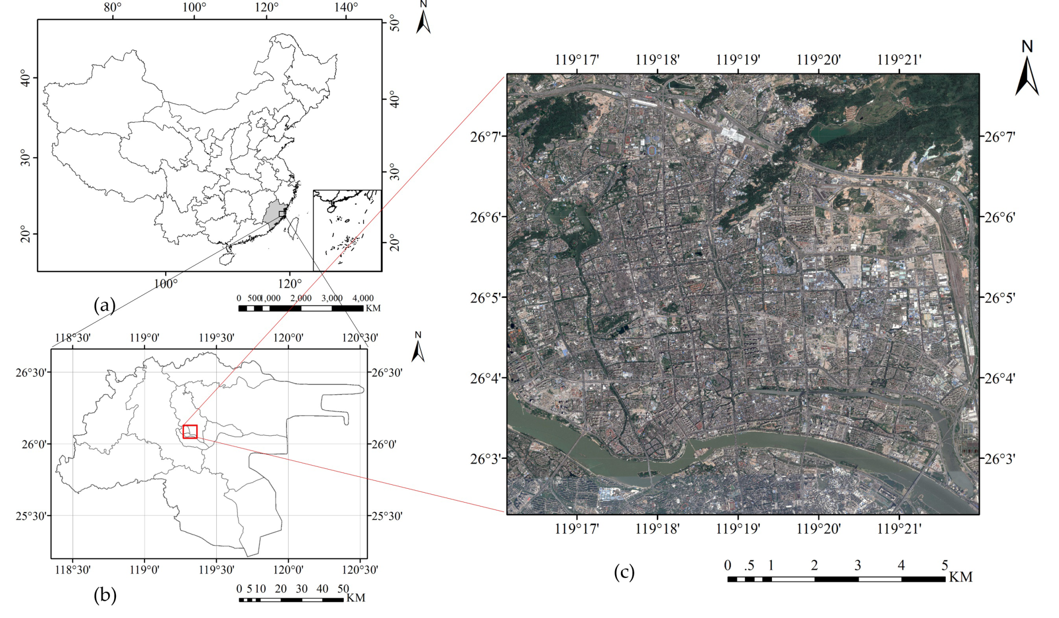
2. Study Area and Data

Located in the coastal region of southeastern China, Fuzhou City is the capital city of the Fujian province. The approximate geographic position of the central city is (26.08°N, 119.3°E). Under the subtropical maritime monsoon climate, it has four distinctive seasons, where the average annual temperature is 19.7 °C and the average annual precipitation is 1348.8 mm. The build-up area of Fuzhou was 265 km2, the population was 7.57 million, and the urbanization rate was 68.5% at the end of 2016. It is also the center city of the Silk Road economic belt and 21st Century Maritime Silk Road. A core area of Fuzhou was selected to explore the performance of the proposed approach. The experiment zone is a rectangular area that has an extent of 10 km both in the east–west and the south–north directions, as shown as Figure 1.
Google Earth played a role as the source of the image data in this research. Up to a sub-meter resolution level, Google Earth provides integrated high-resolution imagery derived from multiple sensors and several platforms, such as QuickBird and WorldView satellites. With 0.6-m spatial resolution, level 18 Google Earth images were downloaded via free software called LocaSpaceViewer (http://www.locaspace.cn/). As the seasonal effect of vegetation growth brings uncertainty for ISA mapping, images from seasons with exuberant vegetation is better for ISA extraction [15]. The experimental image data within the study area was acquired in October 2017. The experimental images were obtained by mosaicking 5254 tiles of level-18 Google Earth images, where each tile was a 256 × 256-pixel picture. The total size of this image was about 985 Megabytes. Under the WGS 1984 Web Mercator coordinate system, this image was cloud-free with three spectral bands (red, green, and blue).
Additionally, the water body vector data was also employed in this study. Obtained from an artificial survey by the Fuzhou Investigation and Surveying Institute, the water body vector data was regarded as ground-truth data for the water.

3. The Proposed Approach

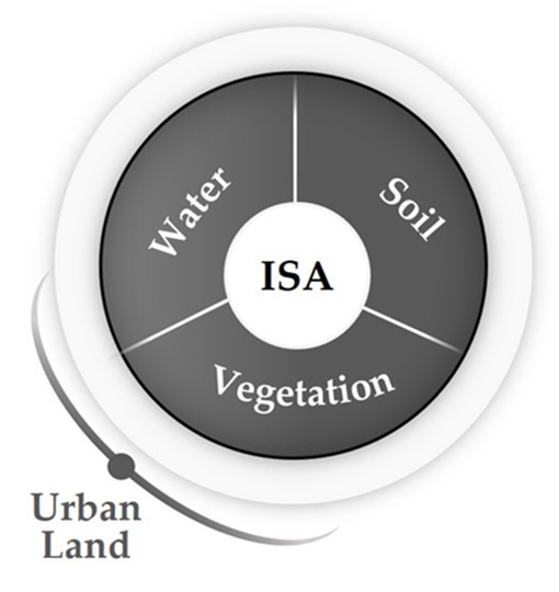
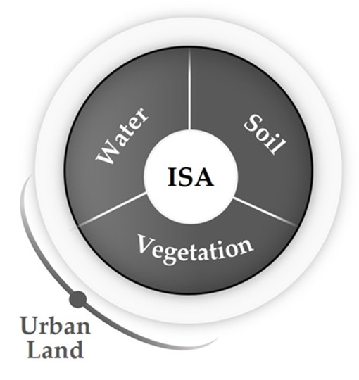
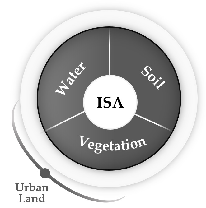
3.1. Proposed Indirect ISA Extraction Conceptual Model

To extract ISA, the urban surface can be divided into target (ISA) and background (non-ISA) from the point of view of target recognition. Thus, the conceptual models for the components of urban land cover that were mentioned in Section 1 can be summarized as ISA and background land cover. In a direct ISA extraction study, the characteristics of ISA should be analyzed. The typical land-cover types of ISA include residential areas, service areas, office areas, and roads. From the perspective of spatial heterogeneity and the spectral variation of urban land cover in high spatial resolution images, the variations of ISA among paint colors, surface types, building materials, geometrical forms, and the illumination-viewing effect are large, which results in obstructions for ISA direct extraction [33]. However, the spectral variations for background land cover, such as vegetation and soil in the V-I-S model, are much lower than for ISA, implying that the background (vegetation and soil) has a higher potential for direct extraction.
As a coarse target, the ISA is difficult to be extracted directly, while the background is easier to be recognized directly. Thus, an indirect ISA extraction conceptual model was proposed based on the direct extracted potential analysis above. This proposed conceptual model was shown graphically as Figure 2. ISA is indirectly extracted by dislodging the background from the total urban land area, as described in Equation (1). The content of the background land cover is shown in Equation (2). In this indirect model, the core of ISA extraction has been transformed to each background land cover, rather than the ISA. In this way, the complexities of direct ISA extraction are evaded.
ISA indirect = UL   B .
where UL refers to urban land, consisting of ISA and background land cover, and B is the background land cover.
B = {   V ,   S ,   W   }
where B is composed of vegetation, soil, and water; and V, S, and W refer to vegetation, soil, and water, respectively.

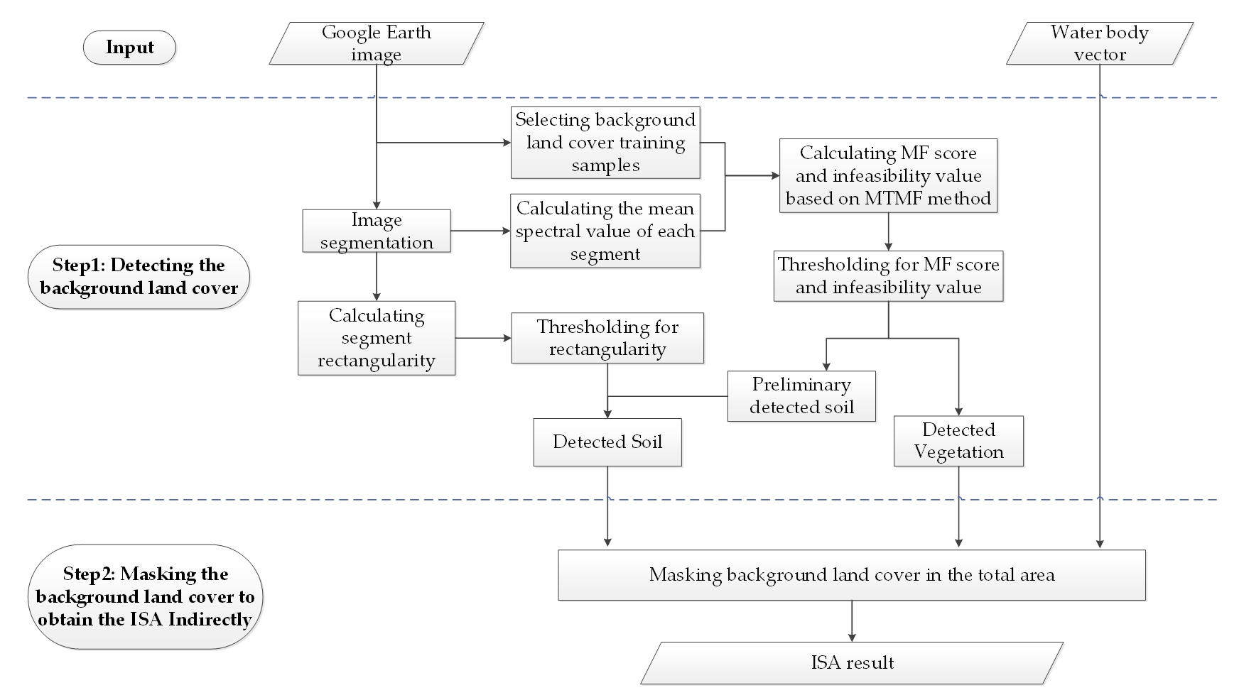
3.2. Proposed Detecting and Masking Background Land Cover Approach

The proposed DMBLC approach was derived from the proposed indirect ISA extraction conceptual model. There are two steps in this approach: (1) detecting the background land cover; and (2) masking the background land cover to obtain the ISA indirectly. The center of DMBLC is to detect the background land cover (water, vegetation, and soil) as accurately as possible. In principle, any data, method, knowledge, or feature with a high potential to detect background land cover can be integrated into DMBLC. In the ideal situation where each background land cover is identified perfectly (for example, by artificial survey), there is no doubt that the ISA can be extracted indirectly perfectly. However, the ideal situation incurs high cost, which is always hard to achieve. Thus, a multi-method integrated instance framework of DMBLC is designed, which is shown in Figure 3.
To deal with the high spatial and spectral variability, as well as confusion in relation to soil within ISA extraction, water body vector data, image segmentation, MTMF, and segment rectangularity are exploited to identify background land cover. This approach firstly utilizes image segmentation, MTMF, and segment rectangularity to detect vegetation and soil. Vegetation is extracted after thresholding the MF score and infeasibility values from MTMF. Soil is detected by thresholding the MF score and infeasibility values from MTMF, and segment rectangularity. Water is directly obtained by water body vector data. Then, by masking the background land cover in the total area, the ISA result is finally produced from this indirect approach. More details are described as follows.

3.2.1. Detecting the Background Land Cover

The performance of the indirect ISA extraction conceptual model and DMBLC approach relies on the accuracy of each background land cover detection. The key of DMBLC is to identify the background land cover using spectral similarity or other features with the corresponding methods and thresholds. As water directly gained from water body vector data, the background land cover that needs to be detected includes the vegetation and soil, based on the proposed indirect ISA extraction conceptual model. In this approach to detecting the background land cover, image segmentation, the MTMF target detection method, and segment rectangularity are utilized in DMBLC to detect vegetation and soil. MTMF is exploited to detect the vegetation and soil targets, while image segmentation is used to mitigate spectral variation problems within the same land cover, and segment rectangularity is used to reduce the confusion between ISA and soil.

Image Segmentation

Since the high spectral variation problem within the same land cover exists in per-pixel based methods, image segmentation is a good choice to mitigate this problem [15]. Image segmentation segments the input image into small homogeneous regions, and has been extensively used for high spatial resolution image classification [34]. Based on the Environment for Visualizing Images (ENVI) software, the edge-based segmentation method is used to produce a preliminary segmentation image that is based on the Google Earth image. To avoid over-segmentation, a full lambda-schedule algorithm [35] is utilized to merge small segments in the textured areas of the preliminary segmentation image [36]. As an indicator of segments’ integrated degree, a merge scale is applied to determine how similar the nearby small segments are in order to merge them into one new bigger segment. In this part, the thresholds for edge-based segmentation scale and merge scale need to be chosen and artificially adjusted in order to obtain a segmentation result with high performance.

Vegetation and Soil Target Detection by MTMF

Driven by only vegetation and soil training samples, MTMF can be implemented to detect the vegetation and soil without other auxiliary information. MTMF is a target detection method that is based on the decomposition of mixed pixels; it consists of two parts: matched filtering (MF) and mixture tuning (MT) [37]. On the one hand, MF calculates the spectral similarity between the undetermined pixel and known target spectrum [38], and produces a result called the MF score to describe their similarity qualitatively. On the other hand, MT reduces the false positive problem in MF processing [39], and produces a result called the infeasibility value to describe the false positivity qualitatively. Thus, undetermined pixels or segments with a high MF score and a low infeasibility value can be identified as targets. In this study, MTMF detection is implemented on the mean spectral value of each segment after image segmentation. Through the thresholding of the MF score and the infeasibility value, the detected vegetation and preliminary detected soil are obtained.

Reducing the Confusion between ISA and Soil by Segment Rectangularity

As numerous ISAs are made from rock, sand, or clayish soil, which are also the main materials of soil, there exists great spectral confusion between ISA and soil in remote sensing images [27]. Due to the spectral confusion between ISA and soil, preliminary soil detection from spectral similarity is not very accurate. Typical, ISAs such as residential areas and office buildings usually have an obvious regularity of shape; for this reason, many researchers use geometric indexes for building extraction [40]. In this study, rectangularity is utilized to improve soil detection performance. Rectangularity refers to the percentage of the segment lying within its minimum bounding rectangle (MBR), and it is a quantitative evaluation indicator that estimates the rectangular fitness of the segment from the aspect of geometric features. It can be obtained by calculating the percentage of the segment’s area that fits within its MBR area. The formula that is used to compute rectangularity is shown in Equation (3) [41]. The segments with high rectangularity are more likely to be ISAs rather than soil. After rectangularity thresholding, only those segments with low rectangularity, which are also preliminary detected soil segments from MTMF, can be identified as the final detected soil. In this part, a threshold of rectangularity needs to be chosen and artificially adjusted in order to achieve a high performance for the detected soil result.
Rectangularity   = Area seg Area MBR × 100 %

3.2.2. Masking the Background Land Cover to Obtain the ISA Indirectly

As described in the proposed indirect ISA extraction conceptual model, all of the background land cover is attained by merging the detected vegetation and soil results from the first step, which involved detecting the background land cover and water from the water body vector data. Through masking the background land cover in the total area, the ISA result is finally obtained indirectly.

4. Experiment and Results Comparison

An experiment was carried out to validate the performance of proposed indirect ISA extraction conceptual model and DMBLC approach. The experiment was performed according to the method and the framework proposed in Section 3.
To compare the performance of the proposed approach, a comparable method needed to be chosen for direct ISA classification. As a supervised classification method derived from statistical learning theory, support vector machines (SVM) [42] has been proved as a powerful and widely used method for its high level of classification accuracy, with even small training samples [43,44]. It was pointed out that SVM should be utilized to explore the performance of urban land and ISA classification in Google Earth images [45]. Nevertheless, for ISA, the pattern of manifestation is so multifarious that if ISA is only regarded as a single class, the performance of SVM would be low. Thus, the SVM with multiple ISA subclasses was utilized as the compared method in this study.
The experiments of the proposed and compared method were implemented by ENVI 5.3 and ArcGIS 10.2 software in the study area, using the data of Section 2. The experiment process, results, and comparisons are shown as follows.

4.1. Experiment Process

4.1.1. Training Samples Selection

Typical training samples were needed for each land cover type in order to drive the proposed and compared method. With the help of the water body vector data, water can be directly obtained. ISA, vegetation, and soil are three coarse land-cover types needed to be extracted or classified in this research. After an overview of the Google Earth images of the study area, eight training samples were selected manually, which included vegetation, soil, and six typical ISA subclasses. Each training sample was the average of several samples that were chosen in the same corresponding land-cover type. The training sample colors were averaged RGB colors from the sample sets, as shown as Table 1. Due to the high separability of training samples, both the Jeffries–Matusita (JM) distance [46] and the transformed divergence (TD) distance [47] of any two samples in Table 1 are more than 1.9.
What is worth mentioning is that the proposed method only needs two background training samples (vegetation and soil in Table 1). The compared method (SVM) needs up to eight training samples (vegetation, soil, and ISA1~ISA6 in Table 1).

4.1.2. Image Segmentation and Rectangularity Calculation

In producing the segmentation image from the Google Earth image, it is important to choose suitable threshold for the edge-based segmentation scale and the merge scale. Therefore, different thresholds ranging from 30, 40, and 50 to 60 for edge detection, and different merge scales ranging from 80, 85, and 90 to 95, were examined in the Google Earth image. Based on the visual examination of the segmentation images, an edge-based segmentation scale of 40 and a merge scale of 90 were finally used in this research. By converting the segmentation image into a vector format, the MBR of each segment could be created, and the rectangularity could be calculated per segment. For each segment, a mean spectral value in each band was calculated for background land cover detection.

4.1.3. Background Land Cover Detection

Based on the vegetation and soil training samples in Table 1, MTMF was implemented in the mean spectral value segmentation image. Each segment had corresponding MF scores and infeasibility values for both vegetation and soil. After thresholding, only if each segment’s MF score (vegetation or soil) was bigger 0.5 and its infeasibility value (vegetation or soil) was less than 20% could it be judged as a target (vegetation or soil). Then, the detected vegetation targets from MTMF were the final detected vegetation results, while the detected soil targets were only the preliminary detected soil.
With the help of segment rectangularity, the rectangular similarity of a segment was quantitatively evaluated. Then, the preliminary detected soil segments from MTMF could be identified as final soil targets only if their rectangularity were less than a threshold. After examining different thresholds ranging from 50% to 70% for rectangularity, a rectangularity detection threshold of 60% was utilized for identifying soil targets.

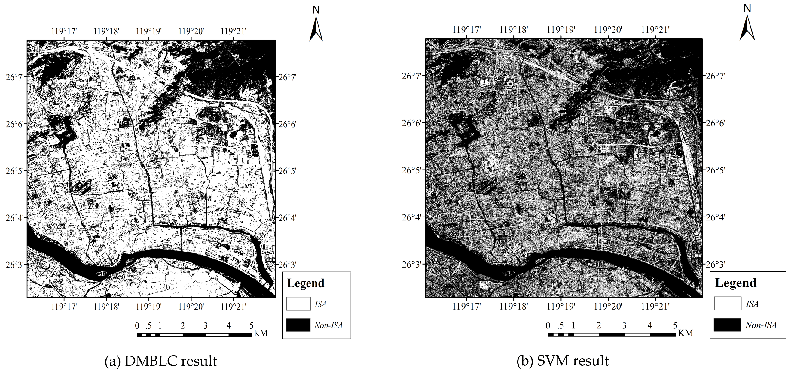
4.2. Result of Proposed and Compared Method for ISA Extraction

The DMBLC-extracted ISA was obtained by masking the water from the water body vector data and identifying the vegetation and soil from the background land cover detection experiment that was described above. The SVM-extracted ISA was achieved by combing the ISA1~ISA6 classification results of SVM. Figure 4 shows the result of the extracted ISA distributions from the proposed DMBLC method compared with the SVM method. Overall, the ISA spatial distributions from both methods are similar for urban land. However, in the core urban areas, the SVM-extracted ISA (Figure 4b) had many more ‘salt-and-pepper’ pixels than those from the DMBLC (Figure 4a), indicating the overestimation of small-size ISA in these areas.

4.3. Performance Comparison between the Proposed and Compared Method

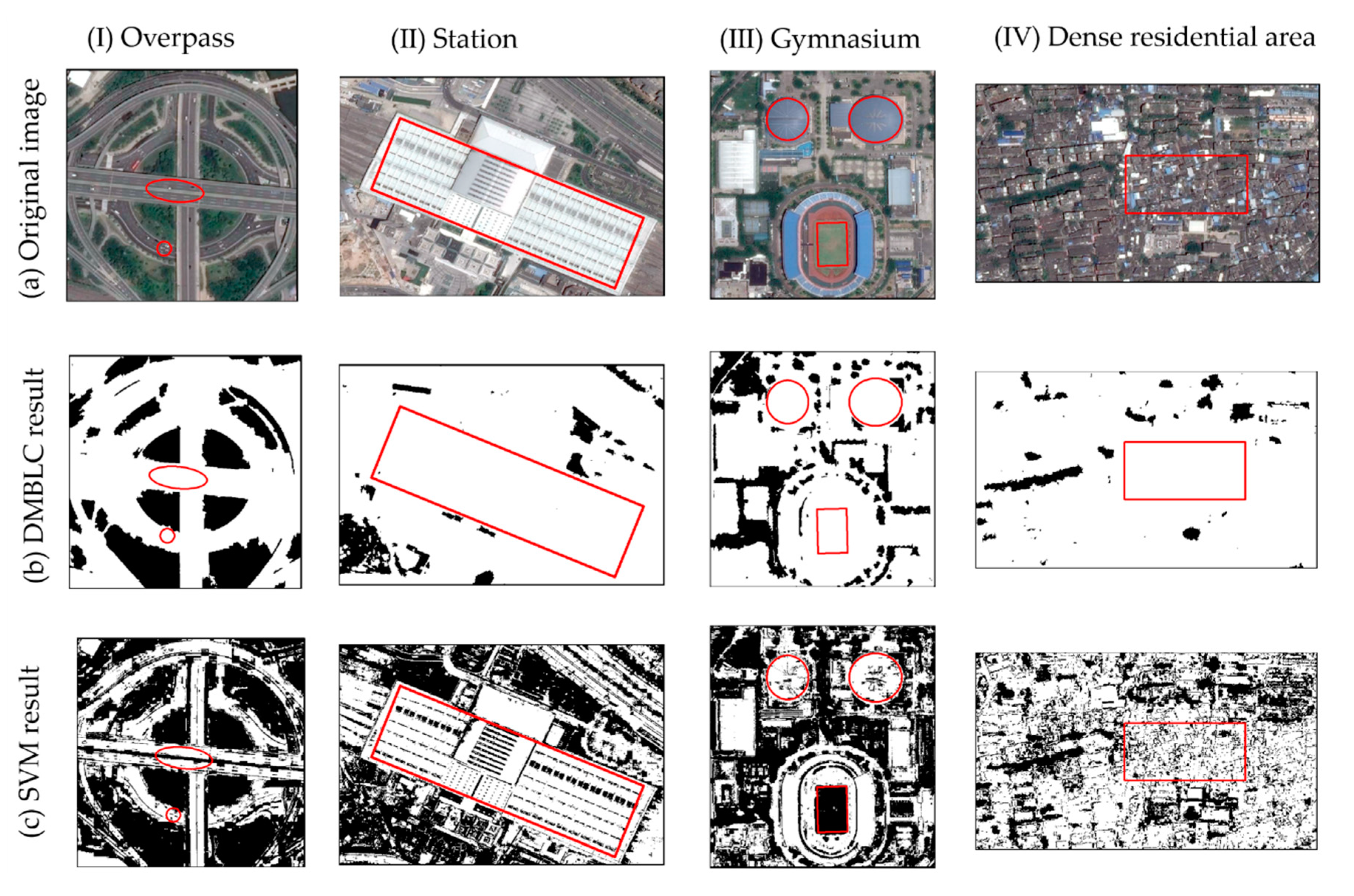
4.3.1. Visual Comparison

Four subsets of representative ISA are selected to compare the effectiveness of the two methods with the original Google Earth image (Figure 5): an overpass, a station, a gymnasium, and a dense residential area. Road infrastructures such as overpasses and highways are a significant component of urban ISA (Figure 5I). The DMBLC method fairly extracted both the agglomerated ISA clusters and the road network in the neighborhood (Figure 5I-b). In contrast, the SVM-extracted ISA (Figure 5I-c) was disturbed by other objects, such as cars on the road. Due to too many characteristics and the spectral variation of the large buildings (Figure 5II-a,III-a), ISA was misclassed in both the DMBLC (Figure 5II-b,III-b) and the SVM methods (Figure 5II-c,III-c). However, there were many more misclassified small details within station in the SVM method (Figure 5II-c) than in the DMBLC method (Figure 5II-b). The football field grass was misclassified as an ISA in the DMBLC method in Figure 5III-b, showing its low performance in low-density vegetation. In the dense residential area (Figure 5IV-a), almost all of the pixels are ISA except for a few areas of vegetation. The noisy, salt-and-pepper appearance in the SVM result (Figure 5IV-c) revealed its underestimation of the ISA and overestimation of the vegetation. Similarly, the DMBLC results showed more accurate ISA distributions than the SVM. Given the 0.6-m resolution of the Google Earth images, the features are so delicate that the SVM-extracted result (Figure 5c) at first appears much more ‘detailed’, but upon examination has more misclassified salt-and-pepper areas. In the visual comparison of both the total and subsets of the study area, the ISA was better delineated from the DMBLC method than the SVM method.

4.3.2. Quantitative Comparison Based on ISA Extraction Accuracy

To qualitatively evaluate the performance of the above methods, the producer’s accuracy (PA), user’s accuracy (UA), overall accuracy (OA), and Kappa coefficient (KC) are calculated from the confusion matrix between the detected result and the artificially selected ground truth in the validation areas [48]. The aim of the ISA extraction study is to extract ISA. Thus, there are only two types of land cover in the final result: ISA and non-ISA. The OA and KC evaluate from a total perspective, while KC is more objective for balancing the inhomogeneity of validation samples by using probability. Higher OA and KC values indicate a better performance in urban ISA extraction.
Accuracy assessment was achieved based on validation samples with ground-truth labels. A 5 × 5-pixel size was adopted for the size of the validation samples, which meant that each sample would cover a quadrate area consisting of 5 × 5 pixels. Under the 0.6-m image spatial resolution, each pixel only covered an area as big as 0.36 m2, which is exquisite for urban surface feature recognition. Located in the homogeneous area, each 5 × 5 pixel sample would only belong to one pure class: ISA, vegetation, or soil. Validation samples were picked from the study area that obeyed randomness and uniformity. Firstly, 400 preliminary samples were auto-selected randomly from the total study area by ArcGIS 10.2. Since the distribution and percentage of soil were much less than that of ISA and vegetation in the study area (which is also common in other urban areas), 200 ISA, 100 vegetation, and 60 soil samples were artificially chosen from the preliminary auto-selected samples except for the samples in water. With artificial recognition of the true land cover type of each sample, the validation samples comprised 200 ISA samples, 100 vegetation samples, and 60 soil samples. The 100 vegetation samples and 60 soil samples were combined as 160 non-ISA samples for calculating the accuracy of ISA extraction. To express the validation samples obviously in Figure 6, each sample had been exaggerated purposely, and magnified a hundred times its original area size.
For the validation samples, the four accuracy measures (PA, UA, OA, and OK) were calculated and compared between the ISA outputs of the proposed DMBLC method and the SVM method from the 0.6-m Google Earth image, as shown in Table 2. For the ISA and non-ISA values of the DMBLC method, the PA and UA were more than 90%, which contributed to its high ISA extraction accuracy. As for SVM, the low PA of its ISA and UA of its non-ISA result in a lower accuracy. Table 2 confirms the qualitatively superior performance of the DMBLC method, with its OA equaling 94.45% and KC equaling 0.8885, respectively.

5. Discussion

This section discusses the merits of the proposed method, as well as its limitations and opportunities for future research.

5.1. Merits of DMBLC

5.1.1. Low Requirement for Training Samples

Under the proposed indirect ISA extraction conceptual model, the attention of the DMBLC method is focused on how to identify the background land cover accurately. The training samples that are needed for DMBLC rely on how many kinds of background land cover need to be detected. As water can be detected directly from water body vector data, two types of training samples are needed to drive MTMF: vegetation and soil. However, the direct method (SVM) needs eight kinds of training samples, as mentioned in Section 4.1.1 and Table 1. In a word, the required number of training samples for the DMBLC method is lower.

5.1.2. High Accuracy of Background Detection and ISA Extraction

The high ISA extraction accuracy of the proposed DMBLC method was outlined in Section 4.3. As seen in Table 2, the OA and KC by MTMF in the DMBLC method equaled 89.71% and 0.7941, respectively, which indicated its superior performance for background land cover detection and ISA indirect extraction compared to the SVM method. To discuss the land cover detection performance between the proposed and compared method in relation to ISA extraction in further detail, this ISA extraction study was transformed into a V-I-S treble land cover classification. In this situation, the V-I-S treble classification result of the DMBLC method consisted of ISA, detected vegetation, and soil targets, while the V-I-S treble classification result of the SVM method was composed of the combined ISA from six subclasses, as well as vegetation and soil targets. The four accuracy measures (PA, UA, OA and OK) of three kinds of land cover were calculated and compared for the three class validation samples in Figure 6, and the results are shown in Table 3. The PA and UA of ISA, and the OA in Table 3 are the same as those in Table 2. Nonetheless, unlike Table 2, the KC in Table 3 refers to an accuracy indicator for V-I-S classification. The vegetation and soil targets in Table 3 are subdivided from the non-ISA values in Table 2. The PA and UA values of vegetation for both the DMBLC and SVM methods were very high, implying the high performance of both methods for vegetation classification. A PA value that was nearly as high, and its much higher UA value for soil in the DMBLC method indicated its high accuracy for soil detection. Although its UA value was nearly as high, the SVM’s lower PA value for ISA showed its lower capability for direct ISA extraction. The OA and KC values of the DMBLC were 8% and 0.12, respectively, which were more than the SVM values, and also confirm the higher potential of indirect ISA extraction (DMBLC) than direct extraction (SVM).
The high spectral similarity between ISA and soil is a constant obstacle in ISA extraction research. As numerous ISAs are made from a similar material as soil, there exists a great spectral similarity between soil and ISA, which results in a much higher misclassification rate for soil than vegetation [27]. That was also proved by calculating the separability of ISA and two kinds of background land cover in 360 validation samples (Figure 6) from the original Google Earth image, as shown in Table 4. Unlike the training samples, which were only selected from the several typical land cover samples, these 360 randomly selected validation samples can more accurately characterize the global situation of the study area. Table 4 shows the spectral separability between the ISA and the background land covers from the global perspective of the total study area. Both the JM and TD distances of soil are lower than those of vegetation. The JM distance of soil is much less than 1.8, which indicates the high degree of spectral mixing between ISA and soil. Under the high spectral similarity between ISA and soil, the OA and KC values of the DMBLC method that are shown in tables 2 and 3 are unexpectedly high, signifying the powerful capability of the indirect DMBLC approach for ISA extraction.

5.1.3. Extensible Capability of the Inner Methods Adopted in DMBLC

Under the proposed indirect ISA extraction conceptual model, the key point of the DMBLC method is to detect background land cover accurately, no matter what kind of method or information is exploited. Thus, from the perspective of the DMBLC’s original design, the inner methods adopted in the DMBLC are extensible, and can be replaced by a more powerful method to detect the background land cover as accurately as possible. In this applied DMBLC approach, the MTMF target detection method, image segmentation, and segment rectangularity were employed. In order to explore the effectiveness and extensive capability of the inner methods that were adopted in the DMBLC method, a comparison of three gradually extended integrations of the methods were implemented: (1) only MTMF; (2) MTMF with image segmentation; and (3) MTMF with image segmentation and rectangularity. A comparison of the ISA extraction performance of these three options is shown in Table 5.
Table 5 reveals that by gradually extended its effective methods or features, the OA and KC of the DMBLC method was further improved. By integrating image segmentation, the high spectral variation within the same land cover was depressed, and the OA and KC improved by 3.01% and 0.0617, respectively. With the further cooperation of rectangularity, the perspective of geometric features alleviated the confusion between ISA and soil, and the OA and KC improved by 1.66% and 0.0327, respectively. The comparison indicates how the inner process of DMBLC improved, and also confirms the effectiveness of the three methods used in the DMBLC framework. The exploration of the gradually increased integration of three methods demonstrates that DMBLC is an extensible integrated indirect ISA extraction strategy with multiple data, methods, knowledge, and features. When other more powerful and available methods or features are made available, such as artificial intelligence techniques and textural features, the inner methods that have been adopted in the present DMBLC model can be replaced or reintegrated to build a new DMBLC approach with better performance.

5.2. Limitations and Future Work

There are several statements and limitations in the design and implementation of the current DMBLC method:
  • As only background land cover needed to be detected in the DMBLC method, the background would be overestimated to a certain degree, especially for soil. Although this kind of overestimation was reduced by rectangularity in this study, the accuracy of soil (PA of 98.00% and UA of 81.29%) in Table 3 indicates the method’s remaining improvement space for soil detection.
  • The DMBLC method’s low performance in low vegetation was shown in Figure 5III-b. The DMBLC method detects background land cover from typical training samples. Thus, the training sample selection is important for accurate land cover detection. The spectral information of the training samples is the average color of the sample sets in the experiment. However, in the study area, the percentage of high vegetation area is much greater than that of the low vegetation area. Thus, when selecting vegetation sample sets, the sample amount of high vegetation is much more than that of low vegetation; as a result, the vegetation training sample in Table 1 is more likely to be high vegetation. So, the vegetation detected by the DMBLC method is more likely to high vegetation.
  • Since the image is not orthorectified, the perspective distortion of the image results in the surrounding areas being overlapped and shadowed by high buildings. This problem is not considered in the proposed indirect ISA extraction conceptual model and DMBLC approach, which would cause an overestimation of ISA.
  • The thresholds for MF score, infeasibility value, and rectangularity of the segment were not auto-selected; instead, they were artificially chosen by changing the values and comparing the performance of the background land cover detection. Thus, the thresholds should be different for other areas. For selecting the best values in other areas, the thresholds for the MF score must be positive, for the infeasibility value reaching about 20%, and for the rectangularity suitability to be more than 50%.
Those problems are hopefully solved by integrating more powerful auxiliary data, knowledge, methods, and features into the DMBLC approach. Future work can focus on the following aspects:
  • Artificial intelligence techniques, such as deep learning, have shown a high performance of vegetation detection in high-resolution images [19]. Other geometric and textural features can also help reduce the confusion between ISA and soil.
  • The free 0.6-m Google Earth image that was used only had three bands, which hinders accuracy improvement. Integration with other resolution optical remote sensing data with more optical band information, synthetic aperture radar (SAR) data with information in the microwave band, and urban digital surface models (DSM) with height information have potential in urban land cover classification [49,50,51]. Integration with information from more optical bands, such as the near-infrared band, can produce powerful remote sensing indices. For example, normalized difference Vegetation Index (NDVI) is a widely recognized vegetation index that is calculated by the red and near-infrared band, and can help detect low vegetation. If the integrated image has enough spectral bands, all of the background land cover (water, vegetation, and soil) can be detected from index-based, SMA and other supervised or unsupervised classification methods. With the help of DSM, the image can be orthorectified, and the height information may further reduce the misclassification between ISA (buildings) and soil.
  • To improve the performance of background land cover detection, the proposed indirect ISA extraction conceptual model can be extended by subdividing the components in the background land cover. This method is similar to the V-H-L-S model, which is extended from the V-I-S model. To strengthen the performance of vegetation detection in areas with low vegetation, the vegetation (in the proposed indirect ISA extraction conceptual model) can be divided into high vegetation and low vegetation. That means that low vegetation will be a new kind of background land cover in the conceptual model, and thus requires a low vegetation training sample to drive the DMBLC method. In the same way, the soil can be divided into dark soil and light soil in order to enhance its soil detection performance.
  • For selecting thresholds for the MF score, the infeasibility value, and the rectangularity of the segment, an auto-selected method needs to be explored in order to widen the application of the DMBLC method.
  • The high performance of the DMBLC approach when using free Google Earth image suggests its usefulness for other high spatial resolution images. Although the DMBLC approach was utilized in high resolution image in this study, it is not limited to other spatial resolution images in the design. DMBLC could also be exploited in free medium spatial resolution remote sensing images, such as Landsat, Sentinel 2, and GaoFen-1.

6. Conclusions

In summary, an indirect ISA extraction conceptual model and a novel indirect ISA extraction approach called DMBLC were proposed for high-resolution, accurate ISA extraction based on freely available high spatial resolution RGB Google Earth images. In the indirect ISA extraction conceptual model, the focus transfers from ISA to background land cover (vegetation, soil, and water) to evade the complexities of direct ISA extraction. In the DMBLC approach, the ISA was indirectly extracted by detecting the background land cover directly, and then masking the background land cover in the total area. The performance of the DMBLC approach relies on the effectiveness of the data, methods, or features that are adopted for background land cover detection. As water can be directly gained by water body vector data, an integration of the MTMF method, image segmentation, and segment rectangularity were utilized for vegetation and soil detection in this study. Using a 0.6-m Google Earth image, the proposed method and a comparison method were tested on a core area of Fuzhou, China. Four findings were drawn from the experimental results and discussion, which are summarized as follows:
  • DMBLC is a powerful indirect ISA extraction approach with a low training samples requirement. DMBLC was driven by background land cover training samples.
  • DMBLC achieved high performance of ISA extraction, with OA equaling 94.45% and KC equaling 0.8885, respectively. The OA and KC of DMBLC were 8% and 0.12 more than those for the SVM method, respectively, revealing the higher accuracy of indirect ISA extraction (DMBLC) than direct extraction (SVM).
  • Demonstration of the gradual extended integration of the three methods within the DMBLC approach showed that based on the high performance of MTMF, image segmentation depressed the high spectral variation within the same land cover, and rectangularity alleviated the confusion between ISA and soil. A comparison of the different levels of complexity in the inner processing steps also confirmed the efficiency and extensibility of the approach.
  • DMBLC is an extensible integrated indirect ISA extraction strategy with multiple data, methods, knowledge, and features. Given other available data, methods or features, the inner methods of DMBLC can be replaced or reintegrated to build a new DMBLC approach that will hopefully achieve better performance.

Author Contributions

M.H., N.C., W.D., Z.C. and J.G. conceived and designed the method and experiments; M.H. performed the experiments, analyzed the data, and wrote the paper; N.C., W.D., Z.C. and J.G. reviewed and commented on the manuscript.

Acknowledgments

This work was supported by the National Key Research and Development Program of China (No. 2017YFB0503803), the Innovation group of natural science fund of Hubei Province (2016 CFA003), the National Nature Science Foundation of China program (Nos. 41771422, 41301441), the Nature Science Foundation of Hubei Province (No. 2017CFB616), the fundamental research funds for the central universities (No. 2042017kf0211), the China Postdoctoral Science Foundation Project (No. 2017M622502), and the LIESMARS Special Research Funding.

Conflicts of Interest

The authors declare no conflict of interest.

References

  1. Slonecker, E.T.; Jennings, D.B.; Garofalo, D. Remote sensing of impervious surfaces: A review. Remote Sens. Rev. 2001, 20, 227–255. [Google Scholar] [CrossRef]
  2. Yan, Y.; Kuang, W.H.; Zhang, C.; Chen, C.B. Impacts of impervious surface expansion on soil organic carbon—A spatially explicit study. Sci. Rep. 2015, 5. [Google Scholar] [CrossRef] [PubMed]
  3. Xu, H.Q.; Lin, D.F.; Tang, F. The impact of impervious surface development on land surface temperature in a subtropical city: Xiamen, china. Int. J. Climatol. 2013, 33, 1873–1883. [Google Scholar] [CrossRef]
  4. Sterling, S.M.; Ducharne, A.; Polcher, J. The impact of global land-cover change on the terrestrial water cycle. Nat. Clim. Chang. 2013, 3, 385–390. [Google Scholar] [CrossRef]
  5. Lepeska, T. The impact of impervious surfaces on ecohydrology and health in urban ecosystems of banska bystrica (slovakia). Soil Water Res. 2016, 11, 29–36. [Google Scholar] [CrossRef]
  6. Shuster, W.D.; Bonta, J.; Thurston, H.; Warnemuende, E.; Smith, D. Impacts of impervious surface on watershed hydrology: A review. Urban Water J. 2005, 2, 263–275. [Google Scholar] [CrossRef]
  7. Du, J.K.; Qian, L.; Rui, H.Y.; Zuo, T.H.; Zheng, D.P.; Xu, Y.P.; Xu, C.Y. Assessing the effects of urbanization on annual runoff and flood events using an integrated hydrological modeling system for qinhuai river basin, china. J. Hydrol. 2012, 464, 127–139. [Google Scholar] [CrossRef]
  8. Du, S.Q.; Shi, P.J.; Van Rompaey, A.; Wen, J.H. Quantifying the impact of impervious surface location on flood peak discharge in urban areas. Nat. Hazards 2015, 76, 1457–1471. [Google Scholar] [CrossRef]
  9. Noori, N.; Kalin, L.; Sen, S.; Srivastava, P.; Lebleu, C. Identifying areas sensitive to land use/land cover change for downstream flooding in a coastal alabama watershed. Reg. Environ. Chang. 2016, 16, 1833–1845. [Google Scholar] [CrossRef]
  10. Kim, H.; Jeong, H.; Jeon, J.; Bae, S. The impact of impervious surface on water quality and its threshold in Korea. Water 2016, 8, 111. [Google Scholar] [CrossRef]
  11. Liu, D.D.; Chen, N.C. Satellite monitoring of urban land change in the middle yangtze river basin urban agglomeration, china between 2000 and 2016. Remote Sens. 2017, 9, 1086. [Google Scholar] [CrossRef]
  12. Weng, Q.H. Remote sensing of impervious surfaces in the urban areas: Requirements, methods, and trends. Remote Sens. Environ. 2012, 117, 34–49. [Google Scholar] [CrossRef]
  13. Schneider, A. Monitoring land cover change in urban and pen-urban areas using dense time stacks of landsat satellite data and a data mining approach. Remote Sens. Environ. 2012, 124, 689–704. [Google Scholar] [CrossRef]
  14. Lu, D.S.; Weng, Q.H. Extraction of urban impervious surfaces from an ikonos image. Int. J. Remote Sens. 2009, 30, 1297–1311. [Google Scholar] [CrossRef]
  15. Lu, D.S.; Hetrick, S.; Moran, E. Impervious surface mapping with quickbird imagery. Int. J. Remote Sens. 2011, 32, 2519–2533. [Google Scholar] [CrossRef] [PubMed]
  16. Yang, J.; He, Y.H. Automated mapping of impervious surfaces in urban and suburban areas: Linear spectral unmixing of high spatial resolution imagery. Int. J. Appl. Earth Obs. 2017, 54, 53–64. [Google Scholar] [CrossRef]
  17. Mering, C.; Baro, J.; Upegui, E. Retrieving urban areas on google earth images: Application to towns of West Africa. Int. J. Remote Sens. 2010, 31, 5867–5877. [Google Scholar] [CrossRef]
  18. Guo, Z.L.; Shao, X.W.; Xu, Y.W.; Miyazaki, H.; Ohira, W.; Shibasaki, R. Identification of village building via google earth images and supervised machine learning methods. Remote Sens. 2016, 8, 271. [Google Scholar] [CrossRef]
  19. Guirado, E.; Tabik, S.; Alcaraz-Segura, D.; Cabello, J.; Herrera, F. Deep-learning versus obia for scattered shrub detection with google earth imagery: Ziziphus lotus as case study. Remote Sens. 2017, 9, 1220. [Google Scholar] [CrossRef]
  20. Yang, X.; Sun, H.; Fu, K.; Yang, J.R.; Sun, X.; Yan, M.L.; Guo, Z. Automatic ship detection in remote sensing images from google earth of complex scenes based on multiscale rotation dense feature pyramid networks. Remote Sens. 2018, 10, 132. [Google Scholar] [CrossRef]
  21. Luo, L.; Wang, X.Y.; Guo, H.D.; Liu, C.S.; Liu, J.; Li, L.; Du, X.C.; Qian, G.Q. Automated extraction of the archaeological tops of qanat shafts from vhr imagery in google earth. Remote Sens. 2014, 6, 11956–11976. [Google Scholar] [CrossRef]
  22. Ridd, M.K. Exploring a v-i-s (vegetation-impervious surface-soil) model for urban ecosystem analysis through remote-sensing—Comparative anatomy for cities. Int. J. Remote Sens. 1995, 16, 2165–2185. [Google Scholar] [CrossRef]
  23. Wu, C.S.; Murray, A.T. Estimating impervious surface distribution by spectral mixture analysis. Remote Sens. Environ. 2003, 84, 493–505. [Google Scholar] [CrossRef]
  24. Xiao, J.F.; Moody, A. A comparison of methods for estimating fractional green vegetation cover within a desert-to-upland transition zone in central New Mexico, USA. Remote Sens. Environ. 2005, 98, 237–250. [Google Scholar] [CrossRef]
  25. Lu, D.S.; Weng, Q.H. Spectral mixture analysis of the urban landscape in indianapolis with landsat etm plus imagery. Photogramm. Eng. Remote Sens. 2004, 70, 1053–1062. [Google Scholar] [CrossRef]
  26. Phinn, S.; Stanford, M.; Scarth, P.; Murray, A.T.; Shyy, P.T. Monitoring the composition of urban environments based on the vegetation-impervious surface-soil (vis) model by subpixel analysis techniques. Int. J. Remote Sens. 2002, 23, 4131–4153. [Google Scholar] [CrossRef]
  27. Xu, H.; Wang, M. Remote sensing-based retrieval of ground impervious surfaces. J. Remote Sens. 2016, 20, 1270–1289. [Google Scholar]
  28. Guo, H.D.; Huang, Q.N.; Li, X.W.; Sun, Z.C.; Zhang, Y. Spatiotemporal analysis of urban environment based on the vegetation-impervious surface-soil model. J. Appl. Remote Sens. 2013, 8. [Google Scholar] [CrossRef]
  29. Xu, R.; Zhang, H.S.; Wang, T.; Lin, H. Using pan-sharpened high resolution satellite data to improve impervious surfaces estimation. Int. J. Appl. Earth Obs. 2017, 57, 177–189. [Google Scholar] [CrossRef]
  30. Zha, Y.; Gao, J.; Ni, S. Use of normalized difference built-up index in automatically mapping urban areas from tm imagery. Int. J. Remote Sens. 2003, 24, 583–594. [Google Scholar] [CrossRef]
  31. Xu, H.Q. Analysis of impervious surface and its impact on urban heat environment using the normalized difference impervious surface index (ndisi). Photogramm. Eng. Remote Sens. 2010, 76, 557–565. [Google Scholar] [CrossRef]
  32. Hu, Q.; Wu, W.B.; Xia, T.; Yu, Q.Y.; Yang, P.; Li, Z.G.; Song, Q. Exploring the use of google earth imagery and object-based methods in land use/cover mapping. Remote Sens. 2013, 5, 6026–6042. [Google Scholar] [CrossRef]
  33. Moreira, R.C.; Galvao, L.S. Variation in spectral shape of urban materials. Remote Sens. Lett. 2010, 1, 149–158. [Google Scholar] [CrossRef]
  34. Mallinis, G.; Koutsias, N.; Tsakiri-Strati, M.; Karteris, M. Object-based classification using quickbird imagery for delineating forest vegetation polygons in a mediterranean test site. ISPRS J. Photogramm. 2008, 63, 237–250. [Google Scholar] [CrossRef]
  35. Robinson, D.J.; Redding, N.J.; Crisp, D.J. Implementation of a Fast Algorithm for Segmenting SAR Imagery. In Scientific and Technical Report 2002; Defense Science and Technology Organization: Edinburgh, Australia, 2002; pp. 1–34. [Google Scholar]
  36. Liu, L.M.; Wen, X.F.; Gonzalez, A.; Tan, D.B.; Du, J.; Liang, Y.T.; Li, W.; Fan, D.K.; Sun, K.M.; Dong, P.; et al. An object-oriented daytime land-fog-detection approach based on the mean-shift and full lambda-schedule algorithms using eos/modis data. Int. J. Remote Sens. 2011, 32, 4769–4785. [Google Scholar] [CrossRef]
  37. Boardman, J.W. Leveraging the high dimensionality of AVIRIS data for improved sub-pixel target unmixing and rejection of false positives: Mixture tuned matched filtering. In Proceedings of the Summaries of the 7th JPL Airborne Geoscience Workshop, Pasadena, CA, USA, 12–16 January 1998; p. 55. [Google Scholar]
  38. Akhter, M.A.; Heylen, R.; Scheunders, P. A geometric matched filter for hyperspectral target detection and partial unmixing. IEEE Geosci. Remote Sens. 2015, 12, 661–665. [Google Scholar] [CrossRef]
  39. Boardman, J.W.; Kruse, F.A. Analysis of imaging spectrometer data using n-dimensional geometry and a mixture-tuned matched filtering approach. IEEE Trans. Geosci. Remote Sens. 2011, 49, 4138–4152. [Google Scholar] [CrossRef]
  40. Huertas, A.; Nevatia, R. Detecting buildings in aerial images. Comput. Vis. Graph 1988, 41, 131–152. [Google Scholar] [CrossRef]
  41. Chen, R.; Li, X.; Li, J. Object-based features for house detection from rgb high-resolution images. Remote Sens. 2018, 10, 451. [Google Scholar] [CrossRef]
  42. Burges, C.J.C. A tutorial on support vector machines for pattern recognition. Data Min. Knowl. Discov. 1998, 2, 121–167. [Google Scholar] [CrossRef]
  43. Pal, M.; Mather, P.M. Support vector machines for classification in remote sensing. Int. J. Remote Sens. 2005, 26, 1007–1011. [Google Scholar] [CrossRef]
  44. Mountrakis, G.; Im, J.; Ogole, C. Support vector machines in remote sensing: A review. ISPRS J. Photogramm. 2011, 66, 247–259. [Google Scholar] [CrossRef]
  45. Bernabe, S.; Plaza, A.; Marpu, P.R.; Benediktsson, J.A. A new parallel tool for classification of remotely sensed imagery. Comput. Geosci. 2012, 46, 208–218. [Google Scholar] [CrossRef]
  46. Bruzzone, L.; Roli, F.; Serpico, S.B. An extension of the jeffreys-matusita distance to multiclass cases for feature selection. IEEE Trans. Geosci. Remote Sens. 1995, 33, 1318–1321. [Google Scholar] [CrossRef]
  47. Richards, J.A.; Jia, X. Remote Sensing Digital Image Analysis: An Introduction, 4th ed.; Springer: Berlin, Germany, 2006. [Google Scholar]
  48. Foody, G.M. Status of land cover classification accuracy assessment. Remote Sens. Environ. 2002, 80, 185–201. [Google Scholar] [CrossRef]
  49. Im, J.; Lu, Z.Y.; Rhee, J.; Quackenbush, L.J. Impervious surface quantification using a synthesis of artificial immune networks and decision/regression trees from multi-sensor data. Remote Sens. Environ. 2012, 117, 102–113. [Google Scholar] [CrossRef]
  50. Zhang, Y.Z.; Zhang, H.S.; Lin, H. Improving the impervious surface estimation with combined use of optical and sar remote sensing images. Remote Sens. Environ. 2014, 141, 155–167. [Google Scholar] [CrossRef]
  51. Huang, X.; Chen, H.J.; Gong, J.Y. Angular difference feature extraction for urban scene classification using zy-3 multi-angle high-resolution satellite imagery. ISPRS J. Photogramm. 2018, 135, 127–141. [Google Scholar] [CrossRef]
Figure 1. The location of the study area: (a) Fuzhou city in China; (b) the study area in Fuzhou city; (c) Google Earth image in the study area.
Remotesensing 10 00766 g001
Figure 2. The diagram of the proposed indirect impervious surface area (ISA) extraction conceptual model. To extract the center white area (ISA) indirectly is to detect and mask the surrounding dark area (background land cover, including vegetation, soil, and water) in the total urban land area.
Remotesensing 10 00766 g002
Figure 3. The framework of the proposed detecting and masking background land cover (DMBLC) approach.
Remotesensing 10 00766 g003
Figure 4. The ISA extraction result using: (a) the DMBLC; and (b) the support vector machines (SVM) method based on 0.6-m spatial resolution Google Earth images. Pixels in white indicate ISA, and pixels in black indicate non-ISA.
Remotesensing 10 00766 g004
Figure 5. The ISA result in four subsets of the study area: (I) Overpass; (II) Station; (III) Gymnasium; and (IV) Dense residential area. The rows are: (a) the original Google Earth image; (b) the DMBLC-extracted ISA result; and (c) the SVM-extracted ISA result. In row (b, c), white pixels indicate ISA, and black pixels indicate non-ISA.
Remotesensing 10 00766 g005
Figure 6. The distribution of the 360 validation samples in study area. Validation samples are indicated in red and comprised 200 ISA samples, 100 vegetation samples, and 60 soil samples.
Remotesensing 10 00766 g006
Table 1. Training samples of each land-cover type.
Land CoverTraining Sample
Vegetation Remotesensing 10 00766 i001
Soil Remotesensing 10 00766 i002
ISA1 Remotesensing 10 00766 i003
ISA2 Remotesensing 10 00766 i004
ISA3 Remotesensing 10 00766 i005
ISA4 Remotesensing 10 00766 i006
ISA5 Remotesensing 10 00766 i007
ISA6 Remotesensing 10 00766 i008
Table 2. Accuracy comparison of the DMBLC and SVM methods for ISA extraction. PA: producer’s accuracy, UA: user’s accuracy, OA: overall accuracy, KC: Kappa coefficient.
MethodLand CoverPA (%)UA (%)OA (%)KC
DMBLCISA92.6797.1494.450.8885
Non-ISA96.6591.47
SVMISA76.2798.8886.440.7329
Non-ISA98.9477.22
Non-ISA in Table 2 refers to vegetation and soil.
Table 3. Accuracy comparison between the DMBLC and SVM methods for classification of ISA, vegetation, and soil.
MethodLand CoverPA (%)UA (%)OA (%)KC
DMBLCISA89.8397.6594.450.9072
Vegetation97.5596.27
Soil98.0081.29
SVMISA76.2798.8886.440.7859
Vegetation98.5788.51
Soil99.5763.67
Table 4. Separability between ISA and background land cover in validation samples. JM: Jeffries–Matusita, TD: transformed divergence.
Background Land CoverJM DistanceTD Distance
Vegetation1.871.99
Soil1.441.85
Table 5. ISA extraction accuracy comparisons of the three gradually extended integrations of the methods that were adopted for the DMBLC method. MTMF: mixture tuned matched filtering.
MethodOA (%)KCOA Improved (%)KC Improved
MTMF89.710.7941
+3.01+0.0617
MTMF + Image segmentation92.790.8558
+1.66+0.0327
MTMF + Image segmentation + Rectangularity94.450.8885

