
Estimation of Boreal Forest Growing Stock Volume in Russia from Sentinel-2 MSI and Land Cover Classification


Abstract
:
1. Introduction
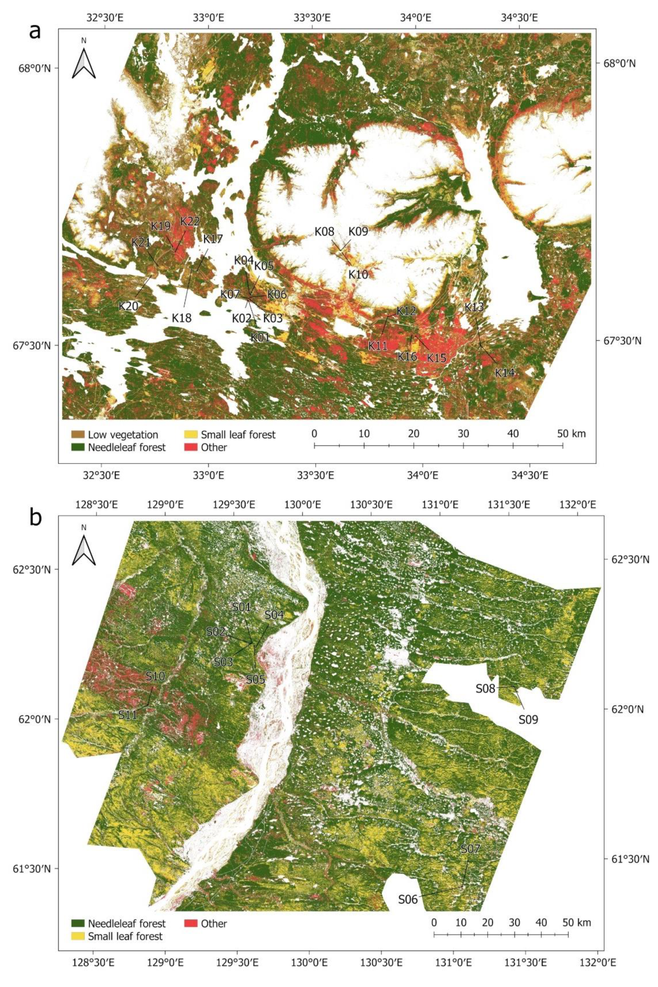
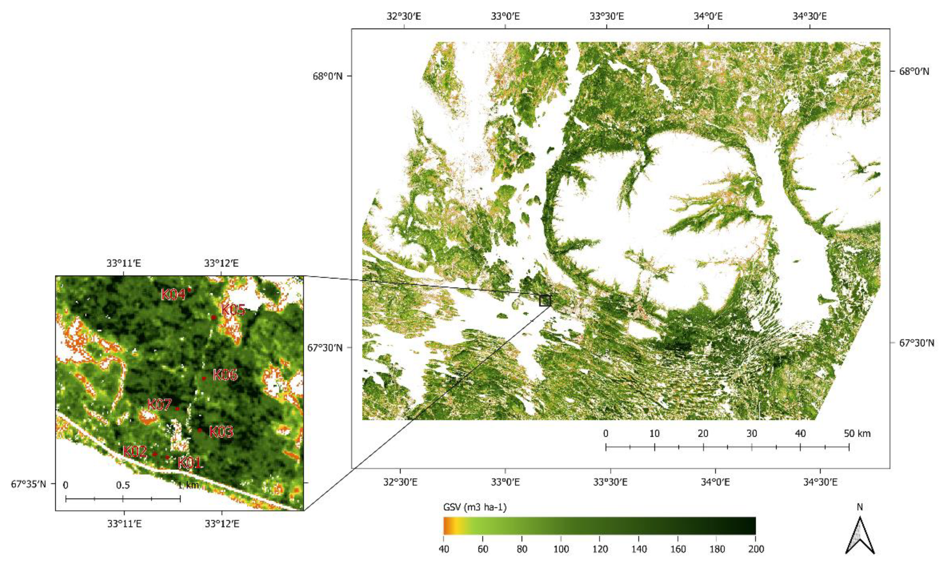
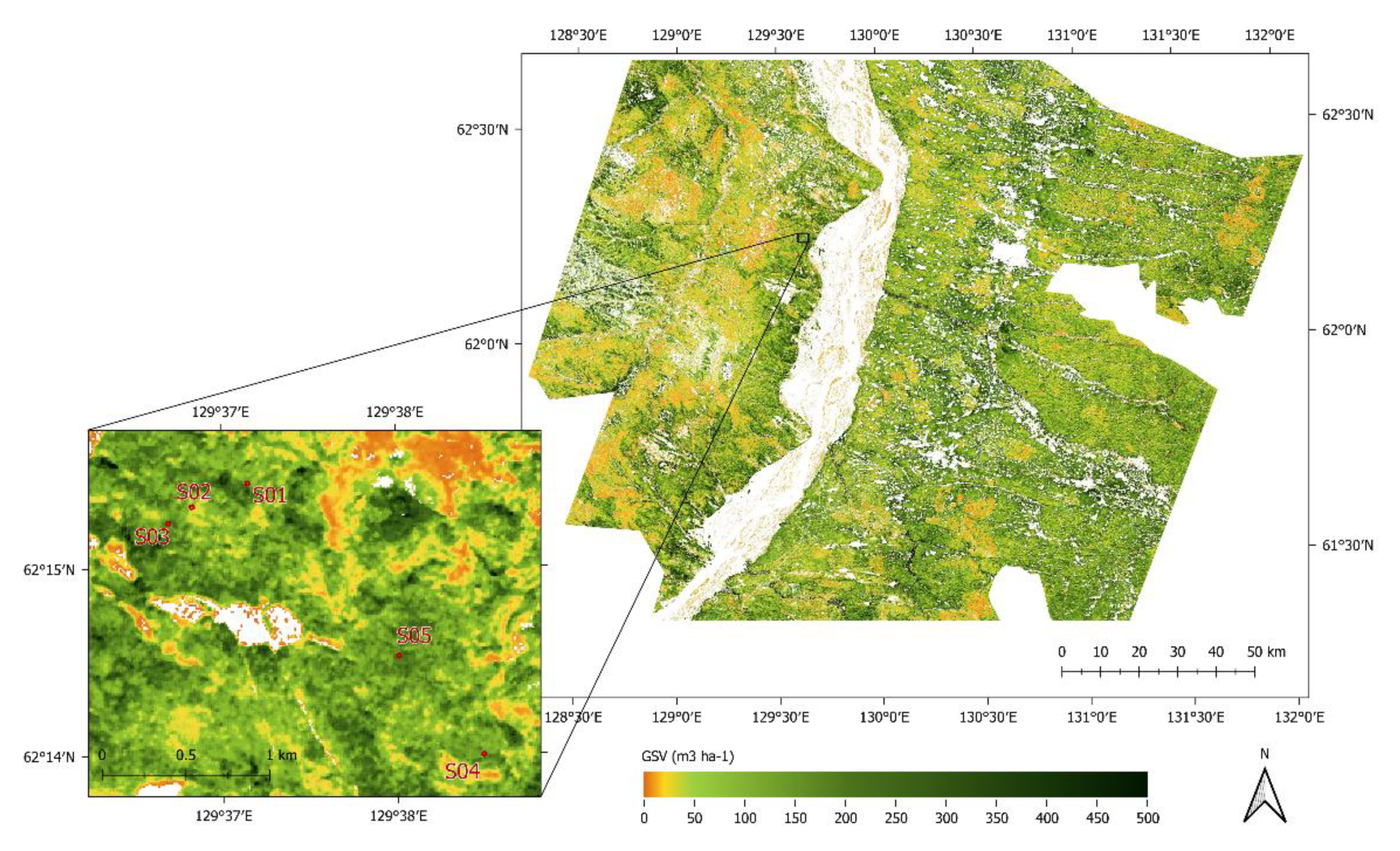
2. Materials and Methods
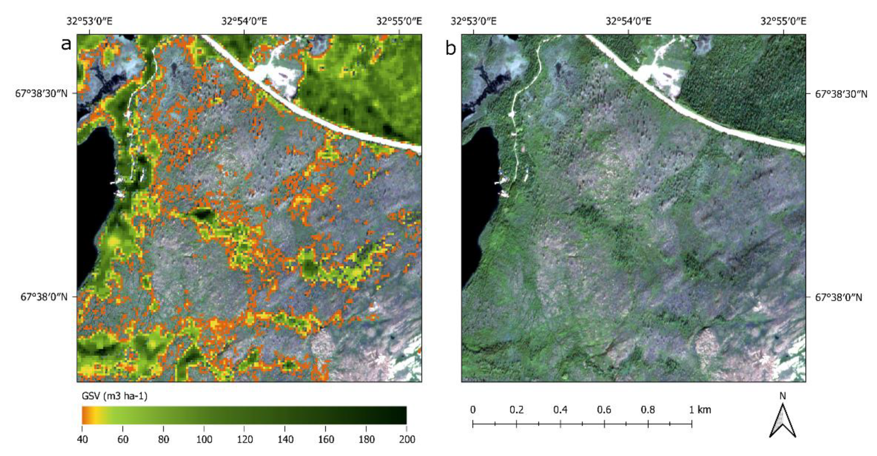
3. Results
4. Discussion
5. Conclusions
Author Contributions
Funding
Data Availability Statement
Acknowledgments
Conflicts of Interest
References
- Santoro, M.; Beer, C.; Cartus, O.; Schmullius, C.; Shvidenko, A.; McCallum, I.; Wegmueller, U.; Wiesmann, A. Retrieval of Growing Stock Volume in Boreal Forest Using Hyper-Temporal Series of Envisat ASAR ScanSAR Backscatter Measurements. Remote Sens. Environ. 2011, 115, 490–507. [Google Scholar] [CrossRef]
- Venäläinen, A.; Lehtonen, I.; Laapas, M.; Ruosteenoja, K.; Tikkanen, O.-P.; Viiri, H.; Ikonen, V.-P.; Peltola, H. Climate Change Induces Multiple Risks to Boreal Forests and Forestry in Finland: A Literature Review. Glob. Chang. Biol. 2020, 26, 4178–4196. [Google Scholar] [CrossRef]
- Seidl, R.; Schelhaas, M.-J.; Rammer, W.; Verkerk, P.J. Increasing Forest Disturbances in Europe and Their Impact on Carbon Storage. Nat. Clim. Chang. 2014, 4, 806–810. [Google Scholar] [CrossRef] [PubMed] [Green Version]
- Dahy, B.; Issa, S.; Ksiksi, T.; Saleous, N. Geospatial Technology Methods for Carbon Stock Assessment: A Comprehensive Review. In 10th Igrsm International Conference and Exhibition on Geospatial & Remote Sensing; Omar, H., Shariff, A.R.M., Sathyamoorthy, D., Mat, R.C., Tarmidi, Z., Ismail, M.H., Eds.; IOP Publishing: Bristol, UK, 2020; Volume 540, p. 012036. [Google Scholar]
- Kaasalainen, S.; Holopainen, M.; Karjalainen, M.; Vastaranta, M.; Kankare, V.; Karila, K.; Osmanoglu, B. Combining Lidar and Synthetic Aperture Radar Data to Estimate Forest Biomass: Status and Prospects. Forests 2015, 6, 252–270. [Google Scholar] [CrossRef]
- Lu, D. The Potential and Challenge of Remote Sensing-based Biomass Estimation. Int. J. Remote Sens. 2006, 27, 1297–1328. [Google Scholar] [CrossRef]
- Lu, D.; Chen, Q.; Wang, G.; Liu, L.; Li, G.; Moran, E. A Survey of Remote Sensing-Based Aboveground Biomass Estimation Methods in Forest Ecosystems. Int. J. Digit. Earth 2016, 9, 63–105. [Google Scholar] [CrossRef]
- Lucas, R.M.; Mitchell, A.L.; Armston, J. Measurement of Forest Above-Ground Biomass Using Active and Passive Remote Sensing at Large (Subnational to Global) Scales. Curr. For. Rep. 2015, 1, 162–177. [Google Scholar] [CrossRef] [Green Version]
- Rodríguez-Veiga, P.; Wheeler, J.; Louis, V.; Tansey, K.; Balzter, H. Quantifying Forest Biomass Carbon Stocks From Space. Curr. For. Rep. 2017, 3, 1–18. [Google Scholar] [CrossRef] [Green Version]
- Villard, L.; Toan, T.L.; Minh, D.H.T.; Mermoz, S.; Bouvet, A. Forest Biomass from Radar Remote Sensing; Baghdadi, N., Zribi, M., Eds.; Elsevier: Amsterdam, The Netherlands, 2016; pp. 363–425. ISBN 978-0-08-101183-6. [Google Scholar]
- Astola, H.; Häme, T.; Sirro, L.; Molinier, M.; Kilpi, J. Comparison of Sentinel-2 and Landsat 8 Imagery for Forest Variable Prediction in Boreal Region. Remote Sens. Environ. 2019, 223, 257–273. [Google Scholar] [CrossRef]
- Chrysafis, I.; Mallinis, G.; Siachalou, S.; Patias, P. Assessing the Relationships between Growing Stock Volume and Sentinel-2 Imagery in a Mediterranean Forest Ecosystem. Remote Sens. Lett. 2017, 8, 508–517. [Google Scholar] [CrossRef]
- Hu, Y.; Xu, X.; Wu, F.; Sun, Z.; Xia, H.; Meng, Q.; Huang, W.; Zhou, H.; Gao, J.; Li, W.; et al. Estimating Forest Stock Volume in Hunan Province, China, by Integrating In Situ Plot Data, Sentinel-2 Images, and Linear and Machine Learning Regression Models. Remote Sens. 2020, 12, 186. [Google Scholar] [CrossRef] [Green Version]
- Jiang, F.; Kutia, M.; Sarkissian, A.J.; Lin, H.; Long, J.; Sun, H.; Wang, G. Estimating the Growing Stem Volume of Coniferous Plantations Based on Random Forest Using an Optimized Variable Selection Method. Sensors 2020, 20, 7248. [Google Scholar] [CrossRef]
- Lovynska, V.; Buchavyi, Y.; Lakyda, P.; Sytnyk, S.; Gritzan, Y.; Sendziuk, R. Assessment of Pine Aboveground Biomass within Northern Steppe of Ukraine Using Sentinel-2 Data. J. For. Sci. 2020, 66, 339–348. [Google Scholar] [CrossRef]
- Mura, M.; Bottalico, F.; Giannetti, F.; Bertani, R.; Giannini, R.; Mancini, M.; Orlandini, S.; Travaglini, D.; Chirici, G. Exploiting the Capabilities of the Sentinel-2 Multi Spectral Instrument for Predicting Growing Stock Volume in Forest Ecosystems. Int. J. Appl. Earth Obs. Geoinf. 2018, 66, 126–134. [Google Scholar] [CrossRef]
- Zheng, S.; Cao, C.; Dang, Y.; Xiang, H.; Zhao, J.; Zhang, Y.; Wang, X.; Guo, H. Retrieval of Forest Growing Stock Volume by Two Different Methods Using Landsat TM Images. Int. J. Remote Sens. 2014, 35, 29–43. [Google Scholar] [CrossRef]
- Le Maire, G.; Marsden, C.; Nouvellon, Y.; Grinand, C.; Hakamada, R.; Stape, J.-L.; Laclau, J.-P. MODIS NDVI Time-Series Allow the Monitoring of Eucalyptus Plantation Biomass. Remote Sens. Environ. 2011, 115, 2613–2625. [Google Scholar] [CrossRef]
- Obata, S.; Cieszewski, C.J.; Lowe, R.C.; Bettinger, P. Random Forest Regression Model for Estimation of the Growing Stock Volumes in Georgia, USA, Using Dense Landsat Time Series and FIA Dataset. Remote Sens. 2021, 13, 218. [Google Scholar] [CrossRef]
- Sanchez-Ruiz, S.; Moreno-Martinez, A.; Izquierdo-Verdiguier, E.; Chiesi, M.; Maselli, F.; Amparo Gilabert, M. Growing Stock Volume from Multi-Temporal Landsat Imagery through Google Earth Engine. Int. J. Appl. Earth Obs. Geoinf. 2019, 83, 101913. [Google Scholar] [CrossRef]
- Wittke, S.; Yu, X.; Karjalainen, M.; Hyyppa, J.; Puttonen, E. Comparison of Two-Dimensional Multitemporal Sentinel-2 Data with Three-Dimensional Remote Sensing Data Sources for Forest Inventory Parameter Estimation over a Boreal Forest. Int. J. Appl. Earth Obs. Geoinf. 2019, 76, 167–178. [Google Scholar] [CrossRef]
- Chrysafis, I.; Mallinis, G.; Tsakiri, M.; Patias, P. Evaluation of Single-Date and Multi-Seasonal Spatial and Spectral Information of Sentinel-2 Imagery to Assess Growing Stock Volume of a Mediterranean Forest. Int. J. Appl. Earth Obs. Geoinf. 2019, 77, 1–14. [Google Scholar] [CrossRef]
- Ataide Goncalves, A.F.; de Moura Fernandes, M.R.; Martins Silva, J.P.; da Silva, G.F.; de Almeida, A.Q.; Cordeiro, N.G.; Caldas da Silva, L.D.; Soares Scolforo, J.R. Wood Volume Estimation in a Semidecidual Seasonal Forest Using MSI and SRTM Data. Floresta E Ambiente 2019, 26, e20180379. [Google Scholar] [CrossRef] [Green Version]
- Hawryło, P.; Francini, S.; Chirici, G.; Giannetti, F.; Parkitna, K.; Krok, G.; Mitelsztedt, K.; Lisańczuk, M.; Stereńczak, K.; Ciesielski, M.; et al. The Use of Remotely Sensed Data and Polish NFI Plots for Prediction of Growing Stock Volume Using Different Predictive Methods. Remote Sens. 2020, 12, 3331. [Google Scholar] [CrossRef]
- Hawrylo, P.; Wezyk, P. Predicting Growing Stock Volume of Scots Pine Stands Using Sentinel-2 Satellite Imagery and Airborne Image-Derived Point Clouds. Forests 2018, 9, 274. [Google Scholar] [CrossRef] [Green Version]
- Maselli, F.; Chiesi, M.; Montaghi, A.; Pranzini, E. Use of ETM plus Images to Extend Stem Volume Estimates Obtained from LiDAR Data. ISPRS J. Photogramm. Remote Sens. 2011, 66, 662–671. [Google Scholar] [CrossRef]
- Puliti, S.; Saarela, S.; Gobakken, T.; Ståhl, G.; Næsset, E. Combining UAV and Sentinel-2 Auxiliary Data for Forest Growing Stock Volume Estimation through Hierarchical Model-Based Inference. Remote Sens. Environ. 2018, 204, 485–497. [Google Scholar] [CrossRef]
- Schumacher, J.; Rattay, M.; Kirchhoefer, M.; Adler, P.; Kaendler, G. Combination of Multi-Temporal Sentinel 2 Images and Aerial Image Based Canopy Height Models for Timber Volume Modelling. Forests 2019, 10, 746. [Google Scholar] [CrossRef] [Green Version]
- Tonolli, S.; Dalponte, M.; Neteler, M.; Rodeghiero, M.; Vescovo, L.; Gianelle, D. Fusion of Airborne LiDAR and Satellite Multispectral Data for the Estimation of Timber Volume in the Southern Alps. Remote Sens. Environ. 2011, 115, 2486–2498. [Google Scholar] [CrossRef]
- Xie, B.; Cao, C.; Xu, M.; Bashir, B.; Singh, R.P.; Huang, Z.; Lin, X. Regional Forest Volume Estimation by Expanding LiDAR Samples Using Multi-Sensor Satellite Data. Remote Sens. 2020, 12, 360. [Google Scholar] [CrossRef] [Green Version]
- Fassnacht, F.E.; Mangold, D.; Schaefer, J.; Immitzer, M.; Kattenborn, T.; Koch, B.; Latifi, H. Estimating Stand Density, Biomass and Tree Species from Very High Resolution Stereo-Imagery—Towards an All-in-One Sensor for Forestry Applications? Forestry 2017, 90, 613–631. [Google Scholar] [CrossRef]
- Immitzer, M.; Stepper, C.; Boeck, S.; Straub, C.; Atzberger, C. Use of WorldView-2 Stereo Imagery and National Forest Inventory Data for Wall-to-Wall Mapping of Growing Stock. For. Ecol. Manag. 2016, 359, 232–246. [Google Scholar] [CrossRef]
- Antropov, O.; Rauste, Y.; Häme, T.; Praks, J. Polarimetric ALOS PALSAR Time Series in Mapping Biomass of Boreal Forests. Remote Sens. 2017, 9, 999. [Google Scholar] [CrossRef] [Green Version]
- Chowdhury, T.A.; Thiel, C.; Schmullius, C. Growing Stock Volume Estimation from L-Band ALOS PALSAR Polarimetric Coherence in Siberian Forest. Remote Sens. Environ. 2014, 155, 129–144. [Google Scholar] [CrossRef]
- Eriksson, L.E.B.; Santoro, M.; Wiesmann, A.; Schmullius, C.C. Multitemporal JERS Repeat-Pass Coherence for Growing-Stock Volume Estimation of Siberian Forest. IEEE Trans. Geosci. Remote Sens. 2003, 41, 1561–1570. [Google Scholar] [CrossRef]
- Gaveau, D.L.A.; Balzter, H.; Plummer, S. Forest Woody Biomass Classification with Satellite-Based Radar Coherence over 900 000 Km(2) in Central Siberia. For. Ecol. Manag. 2003, 174, 65–75. [Google Scholar] [CrossRef]
- Ge, S.; Tomppo, E.; Rauste, Y.; Su, W.; Gu, H.; Praks, J.; Antropov, O. Predicting Growing Stock Volume of Boreal Forests Using Very Long Time Series of Sentinel-1 Data. In Proceedings of the IGARSS 2020—2020 IEEE International Geoscience and Remote Sensing Symposium, Waikoloa, HI, USA, 26 September–2 October 2020; pp. 4509–4512. [Google Scholar]
- Kumar, S.; Garg, R.D.; Govil, H.; Kushwaha, S.P.S. PolSAR-Decomposition-Based Extended Water Cloud Modeling for Forest Aboveground Biomass Estimation. Remote Sens. 2019, 11, 2287. [Google Scholar] [CrossRef] [Green Version]
- Peregon, A.; Yamagata, Y. The Use of ALOS/PALSAR Backscatter to Estimate above-Ground Forest Biomass: A Case Study in Western Siberia. Remote Sens. Environ. 2013, 137, 139–146. [Google Scholar] [CrossRef]
- Persson, H.J.; Olsson, H.; Soja, M.J.; Ulander, L.M.H.; Fransson, J.E.S. Experiences from Large-Scale Forest Mapping of Sweden Using TanDEM-X Data. Remote Sens. 2017, 9, 1253. [Google Scholar] [CrossRef] [Green Version]
- Santoro, M.; Wegmueller, U.; Askne, J. Forest Stem Volume Estimation Using C-Band Interferometric SAR Coherence Data of the ERS-1 Mission 3-Days Repeat-Interval Phase. Remote Sens. Environ. 2018, 216, 684–696. [Google Scholar] [CrossRef]
- Santoro, M.; Beaudoin, A.; Beer, C.; Cartus, O.; Fransson, J.E.S.; Hall, R.J.; Pathe, C.; Schmullius, C.; Schepaschenko, D.; Shvidenko, A.; et al. Forest Growing Stock Volume of the Northern Hemisphere: Spatially Explicit Estimates for 2010 Derived from Envisat ASAR. Remote Sens. Environ. 2015, 168, 316–334. [Google Scholar] [CrossRef]
- Stelmaszczuk-Gorska, M.A.; Rodriguez-Veiga, P.; Ackermann, N.; Thiel, C.; Balzter, H.; Schmullius, C. Non-Parametric Retrieval of Aboveground Biomass in Siberian Boreal Forests with ALOS PALSAR Interferometric Coherence and Backscatter Intensity. J. Imaging 2016, 2, 1. [Google Scholar] [CrossRef] [Green Version]
- Tansey, K.J.; Luckman, A.J.; Skinner, L.; Balzter, H.; Strozzi, T.; Wagner, W. Classification of Forest Volume Resources Using ERS Tandem Coherence and JERS Backscatter Data. Int. J. Remote Sens. 2004, 25, 751–768. [Google Scholar] [CrossRef]
- Wagner, W.; Luckman, A.; Vietmeier, J.; Tansey, K.; Balzter, H.; Schmullius, C.; Davidson, M.; Gaveau, D.; Gluck, M.; Toan, T.T.; et al. Large-Scale Mapping of Boreal Forest in SIBERIA Using ERS Tandem Coherence and JERS Backscatter Data. Remote Sens. Environ. 2003, 85, 125–144. [Google Scholar] [CrossRef]
- Wilhelm, S.; Huettich, C.; Korets, M.; Schmullius, C. Large Area Mapping of Boreal Growing Stock Volume on an Annual and Multi-Temporal Level Using PALSAR L-Band Backscatter Mosaics. Forests 2014, 5, 1999–2015. [Google Scholar] [CrossRef] [Green Version]
- Chen, L.; Ren, C.; Zhang, B.; Wang, Z. Multi-Sensor Prediction of Stand Volume by a Hybrid Model of Support Vector Machine for Regression Kriging. Forests 2020, 11, 296. [Google Scholar] [CrossRef] [Green Version]
- Gao, T.; Zhu, J.; Deng, S.; Zheng, X.; Zhang, J.; Shang, G.; Huang, L. Timber Production Assessment of a Plantation Forest: An Integrated Framework with Field-Based Inventory, Multi-Source Remote Sensing Data and Forest Management History. Int. J. Appl. Earth Obs. Geoinf. 2016, 52, 155–165. [Google Scholar] [CrossRef]
- Ismail, R.; Kassier, H.; Chauke, M.; Holecz, F.; Hattingh, N. Assessing the Utility of ALOS PALSAR and SPOT 4 to Predict Timber Volumes in Even-Aged Eucalyptus Plantations Located in Zululand, South Africa. South. For. 2015, 77, 203–211. [Google Scholar] [CrossRef]
- Mauya, E.W.; Koskinen, J.; Tegel, K.; Hamalainen, J.; Kauranne, T.; Kayhko, N. Modelling and Predicting the Growing Stock Volume in Small-Scale Plantation Forests of Tanzania Using Multi-Sensor Image Synergy. Forests 2019, 10, 279. [Google Scholar] [CrossRef] [Green Version]
- Safari, A.; Sohrabi, H. Integration of Synthetic Aperture Radar and Multispectral Data for Aboveground Biomass Retrieval in Zagros Oak Forests, Iran: An Attempt on Sentinel Imagery. Int. J. Remote Sens. 2020, 41, 8069–8095. [Google Scholar] [CrossRef]
- Urbazaev, M.; Thiel, C.; Cremer, F.; Dubayah, R.; Migliavacca, M.; Reichstein, M.; Schmullius, C. Estimation of Forest Aboveground Biomass and Uncertainties by Integration of Field Measurements, Airborne LiDAR, and SAR and Optical Satellite Data in Mexico. Carbon Balance Manag. 2018, 13, 5. [Google Scholar] [CrossRef] [Green Version]
- Vafaei, S.; Soosani, J.; Adeli, K.; Fadaei, H.; Naghavi, H.; Pham, T.D.; Tien Bui, D. Improving Accuracy Estimation of Forest Aboveground Biomass Based on Incorporation of ALOS-2 PALSAR-2 and Sentinel-2A Imagery and Machine Learning: A Case Study of the Hyrcanian Forest Area (Iran). Remote Sens. 2018, 10, 172. [Google Scholar] [CrossRef] [Green Version]
- Sanchez-Ruiz, S.; Chiesi, M.; Maselli, F.; Gilabert, M.A. Mapping growing stock at 1-km spatial resolution for Spanish areas from ground forest inventory data and GLAS canopy height. In Earth Resources and Environmental Remote Sensing/Gis Applications Vii; Michel, U., Schulz, K., Ehlers, M., Nikolakopoulos, K.G., Civco, D., Eds.; International Society for Optics and Photonics: Bellingham, WA, USA, 2016; Volume 10005, p. 8. ISBN 978-1-5106-0414-8. [Google Scholar]
- Maselli, F. Combination of Optical and LiDAR Satellite Imagery with Forest Inventory Data to Improve Wall-to-Wall Assessment of Growing Stock in Italy. Int. J. Appl. Earth Obs. Geoinf. 2014, 26, 377–386. [Google Scholar] [CrossRef]
- Huettich, C.; Korets, M.; Bartalev, S.; Zharko, V.; Schepaschenko, D.; Shvidenko, A.; Schmullius, C. Exploiting Growing Stock Volume Maps for Large Scale Forest Resource Assessment: Cross-Comparisons of ASAR- and PALSAR-Based GSV Estimates with Forest Inventory in Central Siberia. Forests 2014, 5, 1753–1776. [Google Scholar] [CrossRef] [Green Version]
- Zharko, V.O.; Bartalev, S.A.; Sidorenkov, V.M. Forest Growing Stock Volume Estimation Using Optical Remote Sensing over Snow-Covered Ground: A Case Study for Sentinel-2 Data and the Russian Southern Taiga Region. Remote Sens. Lett. 2020, 11, 677–686. [Google Scholar] [CrossRef]
- Jarnstedt, J.; Pekkarinen, A.; Tuominen, S.; Ginzler, C.; Holopainen, M.; Viitala, R. Forest Variable Estimation Using a High-Resolution Digital Surface Model. ISPRS J. Photogramm. Remote Sens. 2012, 74, 78–84. [Google Scholar] [CrossRef]
- Strunk, J.; Packalen, P.; Gould, P.; Gatziolis, D.; Maki, C.; Andersen, H.-E.; McGaughey, R.J. Large Area Forest Yield Estimation with Pushbroom Digital Aerial Photogrammetry. Forests 2019, 10, 397. [Google Scholar] [CrossRef] [Green Version]
- Zhou, J.; Zhou, Z.; Zhao, Q.; Han, Z.; Wang, P.; Xu, J.; Dian, Y. Evaluation of Different Algorithms for Estimating the Growing Stock Volume of Pinus Massoniana Plantations Using Spectral and Spatial Information from a SPOT6 Image. Forests 2020, 11, 540. [Google Scholar] [CrossRef]
- Schepaschenko, D.; Moltchanova, E.; Fedorov, S.; Karminov, V.; Ontikov, P.; Santoro, M.; See, L.; Kositsyn, V.; Shvidenko, A.; Romanovskaya, A.; et al. Russian Forest Sequesters Substantially More Carbon than Previously Reported. Sci. Rep. 2021, 11, 12825. [Google Scholar] [CrossRef] [PubMed]
- Rees, W.G.; Hofgaard, A.; Boudreau, S.; Cairns, D.M.; Harper, K.; Mamet, S.; Mathisen, I.; Swirad, Z.; Tutubalina, O. Is Subarctic Forest Advance Able to Keep Pace with Climate Change? Glob. Chang. Biol. 2020, 26, 3965–3977. [Google Scholar] [CrossRef] [PubMed] [Green Version]
- FAO. Global Forest Resources Assessment 2015: How Are the World’s Forests Changing? Food and Agriculture Organisation of the United Nations: Rome, Italy, 2016; p. 54. [Google Scholar]
- Rees, W.G.; Golubeva, E.I.; Tutubalina, O.V.; Zimin, M.V.; Derkacheva, A.A. Relation between Leaf Area Index and NDVI for Subarctic Deciduous Vegetation. Int. J. Remote Sens. 2020, 41, 8573–8589. [Google Scholar] [CrossRef]
- Alekseev, A.; Tomppo, E.; McRoberts, R.E.; von Gadow, K. A Constructive Review of the State Forest Inventory in the Russian Federation. For. Ecosyst. 2019, 6, 9. [Google Scholar] [CrossRef] [Green Version]
- Vikulina, M.A.; Vashchalova, T.V.; Tutubalina, O.V.; Rees, W.G.; Zaika, Y.V. Moscow University’s Field Station in the Khibiny Mountains, Russian Arctic: A 70-Year History to the Present Day. Polar Rec. 2021, 57, e10. [Google Scholar] [CrossRef]
- Stone, T.A.; Schlesinger, P. RLC Forest Cover Map of the Former Soviet Union, 1990; ORNL DAAC: Oak Ridge, TN, USA, 2004. [CrossRef]
- Isaev, A.S. Forest Map of the USSR at Scale 1:2500000 Moscow; Central Administration for Geodesy and Cartography (GUGK): Moscow, Russia, 1990. [Google Scholar]
- Zianis, D.; Muukkonen, P.; Mäkipää, R.; Mencuccini, M. Biomass and Stem Volume Equations for Tree Species in Europe; Silva Fennica Monographs; Finnish Society of Forest Science: Tampere, Finland, 2005. [Google Scholar]
- Eaton, J.; Bateman, D.; Hauberg, S.; Wehbring, R. GNU Octave Version 4.0.0 Manual: A High-Level Interactive Language for Numerical Computations. Available online: http://www.gnu.org/software/octave/doc/interpreter/ (accessed on 5 November 2021).
- Congedo, L. Semi-Automatic Classification Plugin Documentation Release 7.0.0.1 Luca Congedo. 2020. Available online: https://www.researchgate.net/publication/344876862_Semi-Automatic_Classification_Plugin_Documentation_Release_7971 (accessed on 5 November 2021).
- QGIS Development Team. QGIS Geographic Information System; QGIS Association. 2021. Available online: https://www.qgis.org/en/site/ (accessed on 5 November 2021).
- Bartalev, S.; Egorov, V.; Zharko, V.; Loupian, E.; Plotnikov, D.; Khvostikov, S.; Shabanov, N. Land Cover Mapping over Russia Using Earth Observation Data; Russian Academy of Sciences’ Space Research Institute: Moscow, Russia, 2016. (In Russian) [Google Scholar]
- Bartalev, S.; Egorov, V.; Erhsov, D.; Isaev, A.; Loupian, E.; Plotnikov, D.; Uvarov, A. Mapping of Russia’s Vegetation Cover Using MODIS Satellite Spectroradiometer Data. Sovrem. Probl. Distantsionnogo Zondirovaniya Zemli Iz Kosm. [Curr. Probl. Remote Sens. Earth Space] 2011, 8, 285–302. (In Russian) [Google Scholar]
- Balashov, I.; Bartalev, S.; Burtsev, M.; Vorushilov, I.; Egorov, V.; Kashnitskii, A.; Khovratovich, T.; Khvostikov, S.A.; Kobets, D.; Loupian, E.; et al. Vega-Les Information System. Actual Features and Future Evolution. IOP Conf. Ser. Earth Environ. Sci. 2020, 507, 012002. [Google Scholar] [CrossRef]
- McFeeters, S.K. The Use of the Normalized Difference Water Index (NDWI) in the Delineation of Open Water Features. Int. J. Remote Sens. 1996, 17, 1425–1432. [Google Scholar] [CrossRef]
- Rees, W. Comparing the Spatial Content of Thematic Maps. Int. J. Remote Sens. 2008, 29, 3833–3844. [Google Scholar] [CrossRef]
- Wang, J.A.; Baccini, A.; Farina, M.; Randerson, J.T.; Friedl, M.A. Disturbance Suppresses the Aboveground Carbon Sink in North American Boreal Forests. Nat. Clim. Chang. 2021, 11, 435–441. [Google Scholar] [CrossRef]
- Hansen, M.C.; Potapov, P.V.; Moore, R.; Hancher, M.; Turubanova, S.A.; Tyukavina, A.; Thau, D.; Stehman, S.V.; Goetz, S.J.; Loveland, T.R.; et al. High-Resolution Global Maps of 21st-Century Forest Cover Change. Science 2013, 342, 850. [Google Scholar] [CrossRef] [Green Version]
- Sexton, J.O.; Song, X.-P.; Feng, M.; Noojipady, P.; Anand, A.; Huang, C.; Kim, D.-H.; Collins, K.M.; Channan, S.; DiMiceli, C.; et al. Global, 30-m Resolution Continuous Fields of Tree Cover: Landsat-Based Rescaling of MODIS Vegetation Continuous Fields with Lidar-Based Estimates of Error. Int. J. Digit. Earth 2013, 6, 427–448. [Google Scholar] [CrossRef] [Green Version]


| Study Area | Image Date | Processing Level | Cloud Cover (%) |
|---|---|---|---|
| Khibiny | 2018.04.17 | 1C | 0 |
| 2018.07.02 | 1C | 0.35 | |
| Sakha | 2019.04.02 | 1C | 1.03 |
| 2019.07.24 | 2A | 0.93 [13.29] |
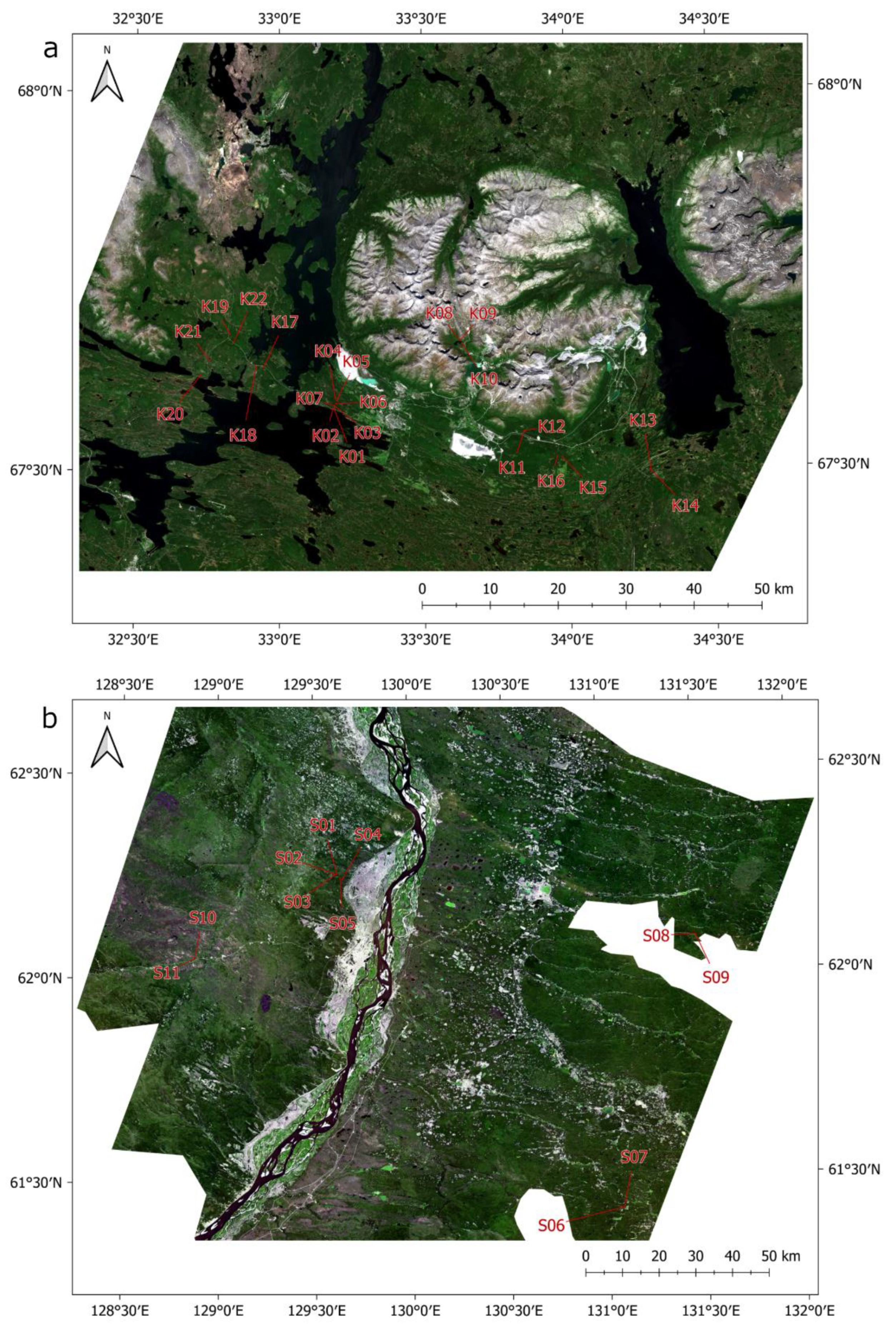
| Site No | Centre Coordinates | All Trees, per ha | Mean | Percentage V, per Genus | ||||||
|---|---|---|---|---|---|---|---|---|---|---|
| Lat | Long | n | a (m2) | V (m3) | H (m) | Betula | Picea | Pinus | Other | |
| K01 | 67.58203 | 33.18883 | 1575 | 21.9 | 94.2 | 7.0 | 68 | 10 | 22 | 0 |
| K02 | 67.58228 | 33.18628 | 200 | 5.3 | 36.9 | 9.2 | 13 | 87 | 0 | 0 |
| K03 | 67.58414 | 33.19546 | 1500 | 23.1 | 187.0 | 14.2 | 1 | 0 | 99 | 0 |
| K04 | 67.59514 | 33.19341 | 16,800 | 28.9 | 96.9 | 5.8 | 93 | 0 | 4 | 2 |
| K05 | 67.59296 | 33.19844 | 8000 | 69.6 | 444.4 | 10.5 | 11 | 0 | 88 | 1 |
| K06 | 67.58821 | 33.19638 | 2700 | 29.6 | 136.5 | 7.1 | 14 | 0 | 84 | 2 |
| K07 | 67.58583 | 33.19092 | 1900 | 21.8 | 119.7 | 7.9 | 13 | 0 | 85 | 2 |
| K08 | 67.67161 | 33.62433 | 975 | 18.0 | 125.6 | 8.6 | 26 | 71 | 0 | 3 |
| K09 | 67.67110 | 33.62790 | 900 | 7.4 | 24.7 | 5.8 | 95 | 0 | 0 | 5 |
| K10 | 67.66619 | 33.63556 | 1550 | 5.1 | 14.7 | 4.1 | 100 | 0 | 0 | 0 |
| K11 | 67.55072 | 33.84543 | 2000 | 38.5 | 198.6 | 8.6 | 11 | 89 | 0 | 0 |
| K12 | 67.55111 | 33.84805 | 4900 | 44.8 | 227.7 | 9.0 | 48 | 49 | 0 | 2 |
| K13 | 67.49549 | 34.28193 | 2500 | 41.8 | 226.1 | 8.4 | 10 | 10 | 80 | 0 |
| K14 | 67.49772 | 34.27876 | 1450 | 13.5 | 56.2 | 7.8 | 73 | 27 | 0 | 0 |
| K15 | 67.51534 | 33.97614 | 3200 | 31.2 | 163.3 | 8.5 | 16 | 84 | 0 | 0 |
| K16 | 67.51642 | 33.95854 | 1100 | 18.3 | 90.9 | 8.2 | 13 | 87 | 0 | 0 |
| K17 | 67.63669 | 32.94625 | 800 | 17.2 | 81.7 | 9.8 | 47 | 53 | 0 | 0 |
| K18 * | 67.63816 | 32.91997 | 400 | 0.6 | 1.4 | 2.7 | 92 | 0 | 0 | 8 |
| K19 | 67.67987 | 32.82885 | 850 | 19.4 | 112.4 | 9.0 | 5 | 95 | 0 | 0 |
| K20 | 67.62647 | 32.72848 | 875 | 13.4 | 73.9 | 6.4 | 8 | 20 | 71 | 2 |
| K21 | 67.64500 | 32.75837 | 1600 | 9.0 | 32.6 | 5.2 | 10 | 0 | 67 | 23 |
| K22 | 67.66966 | 32.84158 | 2400 | 20.7 | 94.0 | 7.4 | 47 | 49 | 0 | 4 |
| Site No | Centre Coordinates | All Trees, per ha | Mean | Percentage V, per Genus | ||||||
|---|---|---|---|---|---|---|---|---|---|---|
| Lat | Long | n | a (m2) | V (m3) | H (m) | Betula | Larix | Pinus | Other | |
| S01 | 62.25452 | 129.62300 | 1800 | 26.6 | 207.5 | 10.2 | 1 | 99 | 0 | 0 |
| S02 | 62.25328 | 129.61670 | 2400 | 9.5 | 47.1 | 8.7 | 87 | 11 | 0 | 2 |
| S03 | 62.25242 | 129.61390 | 2800 | 16.3 | 100.7 | 10.0 | 38 | 60 | 1 | 0 |
| S04 | 62.23995 | 129.64990 | 3550 | 18.2 | 93.5 | 5.3 | 0 | 3 | 97 | 0 |
| S05 | 62.24525 | 129.64030 | 3250 | 23.4 | 191.7 | 7.4 | 4 | 95 | 0 | 1 |
| S06 | 61.42577 | 131.07350 | 5000 | 21.0 | 155.8 | 12.9 | 100 | 0 | 0 | 0 |
| S07 | 61.42620 | 131.07630 | 3275 | 30.0 | 231.8 | 12.1 | 30 | 70 | 0 | 0 |
| S08 | 62.08837 | 131.48700 | 6900 | 15.1 | 74.4 | 6.3 | 16 | 84 | 0 | 0 |
| S09 | 62.08819 | 131.49170 | 3100 | 26.1 | 212.3 | 12.4 | 0 | 100 | 0 | 0 |
| S10 | 62.05120 | 128.87790 | 375 | 1.6 | 8.7 | 3.6 | 2 | 98 | 0 | 0 |
| S11 | 62.04870 | 128.87580 | 825 | 10.6 | 62.2 | 7.7 | 0 | 0 | 100 | 0 |
| Study Area | VEGA Land Cover Classification | Generalisation |
|---|---|---|
| Khibiny | Shrub tundra | Low vegetation |
| peatlands | ||
| Evergreen dark needleleaf forest | Needleleaf forest | |
| Evergreen light needleleaf forest | ||
| Broadleaf shrubs | Small-leaf forest | |
| Humid grassland | ||
| Mixed with needleleaf majority | other | |
| Broadleaf forest | ||
| Sakha | Deciduous needleleaf forest | Needleleaf forest |
| Evergreen light needleleaf forest | ||
| Broadleaf forest | Small-leaf forest | |
| Mixed with needleleaf majority | other | |
| Recent burns |
| Study Area | Parameter | Coefficient | r2 | ΔlnG |
|---|---|---|---|---|
| Khibiny | 10.823 | 0.679 | 0.53 | |
| MSI3 | 8.752 × 10⁻³ | |||
| Low vegetation | 0.2209 | |||
| Needleleaf forest | −0.0903 | |||
| Sakha | 11.963 | 0.787 | 0.34 | |
| MSI2 | 0.01129 | |||
| MSI3 | −0.02274 | |||
| Needleleaf forest | 0.11192 |
Publisher’s Note: MDPI stays neutral with regard to jurisdictional claims in published maps and institutional affiliations. |
© 2021 by the authors. Licensee MDPI, Basel, Switzerland. This article is an open access article distributed under the terms and conditions of the Creative Commons Attribution (CC BY) license (https://creativecommons.org/licenses/by/4.0/).
Share and Cite
Rees, W.G.; Tomaney, J.; Tutubalina, O.; Zharko, V.; Bartalev, S. Estimation of Boreal Forest Growing Stock Volume in Russia from Sentinel-2 MSI and Land Cover Classification. Remote Sens. 2021, 13, 4483. https://0-doi-org.brum.beds.ac.uk/10.3390/rs13214483
Rees WG, Tomaney J, Tutubalina O, Zharko V, Bartalev S. Estimation of Boreal Forest Growing Stock Volume in Russia from Sentinel-2 MSI and Land Cover Classification. Remote Sensing. 2021; 13(21):4483. https://0-doi-org.brum.beds.ac.uk/10.3390/rs13214483
Chicago/Turabian StyleRees, W. Gareth, Jack Tomaney, Olga Tutubalina, Vasily Zharko, and Sergey Bartalev. 2021. "Estimation of Boreal Forest Growing Stock Volume in Russia from Sentinel-2 MSI and Land Cover Classification" Remote Sensing 13, no. 21: 4483. https://0-doi-org.brum.beds.ac.uk/10.3390/rs13214483