
Monitoring and Analyzing Yield Gap in Africa through Soil Attribute Best Management Using Remote Sensing Approaches: A Review

 ,
,  , and
, and
Abstract
:1. Introduction
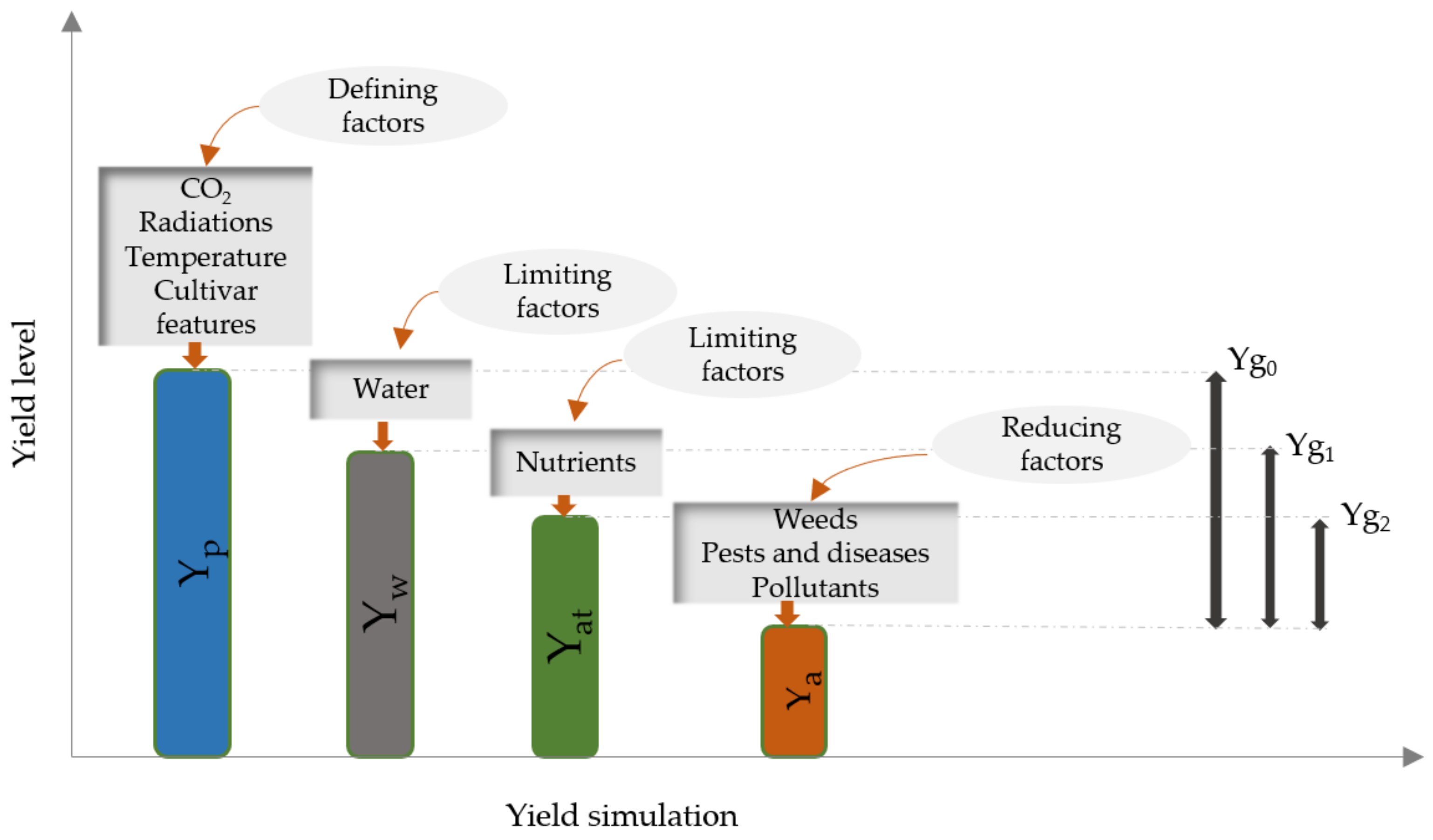
2. Overview of Yield Gap Analysis Techniques
2.1. Remote Sensing
2.2. Modeling
2.3. Boundary Functions
2.4. Studies Combining Remote Sensing-Based Soil Properties Mapping and Advanced Modeling Approaches for Yield Gap Estimation
3. Methodology
- (TITLE-ABS-KEY (“yield gap”) AND TITLE-ABS-KEY (country) AND TITLE-AB S-KEY (yield OR field OR scale OR production OR approach)).
- (TITLE-ABS-KEY (“yield gap”) AND TITLE-ABS-KEY (“soil properties” OR “soil attributes” OR calcium OR potassium OR ph OR clay OR silt OR sand OR “soil organic carbon” OR “ soil texture” OR nutrient* OR cec) AND TITLE-ABS-KEY (yield OR field OR scale OR production OR approach) AND TITLE-ABS-KEY (Ghana));
- (TITLE-ABS-KEY (landsat) AND TITLE-ABS-KEY (Morocco OR Senegal OR Tunisia OR “Cote d’Ivoire” OR Kenya OR “South Africa” OR Ethiopia OR Cameroon OR “Burkina Faso” OR Rwanda OR Ghana OR Tanzania) AND TITLE (“soil properties” OR “soil attributes” OR calcium OR potassium OR ph OR clay OR silt OR sand OR “soil organic carbon” OR “ soil texture” OR nutrient* OR cec OR production OR yield) AND NOT TITLE-ABS-KEY (erosion) AND NOT TITLE-ABS-KEY (alteration) AND NOT TITLE-ABS-KEY (moisture) AND NOT TITLE-ABS-KEY (degradation) AND NOT TITLE-ABS-KEY (dune*)).
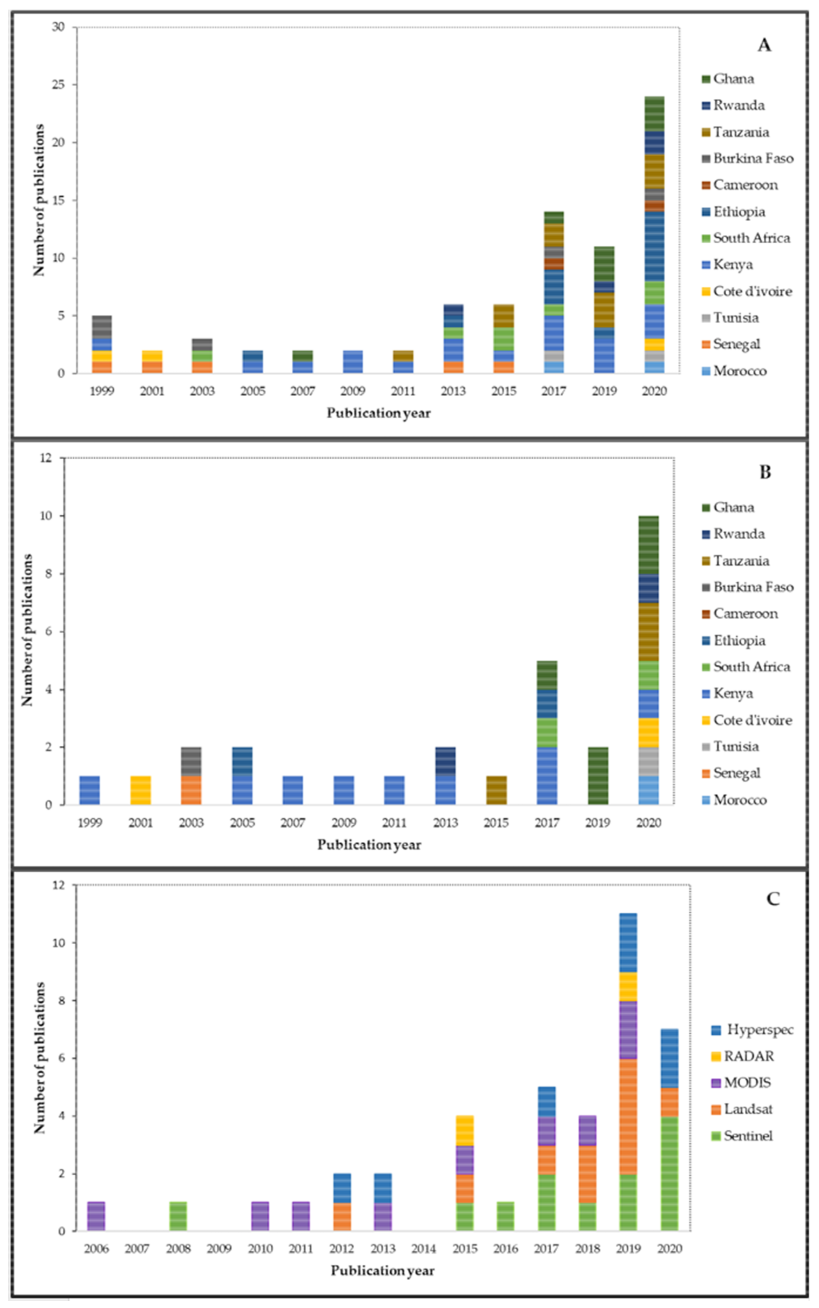
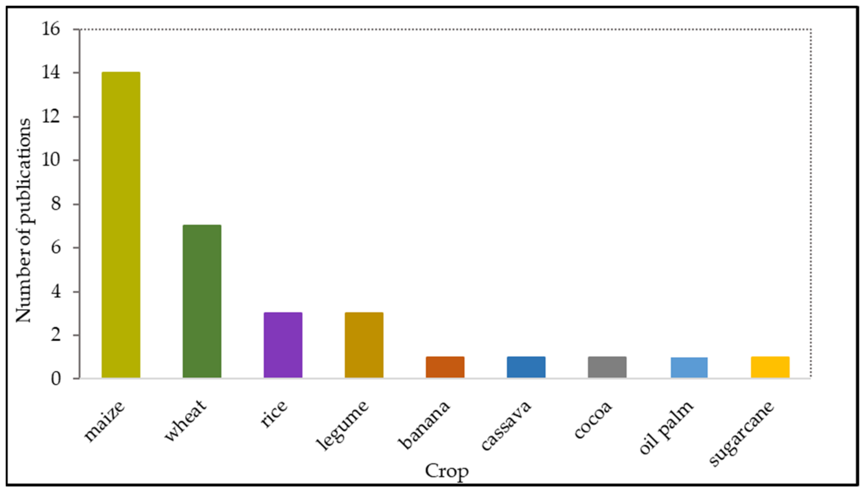
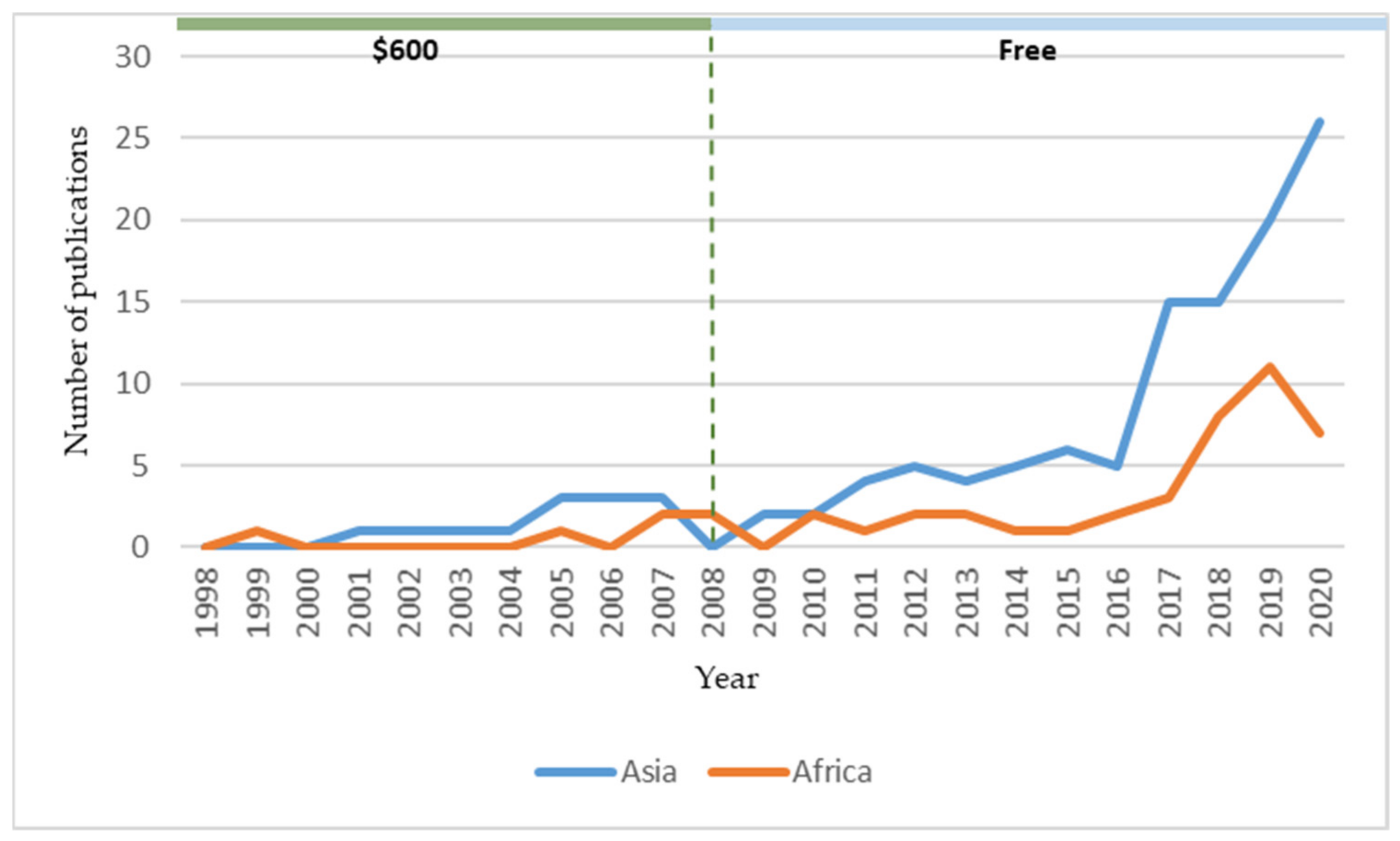
4. Results

| Publication Year | Study Area/Country | Remote Sensing (RS) Data | Study Crop/Soil Properties | RS Data Analysis Techniques | Reference |
|---|---|---|---|---|---|
| 2012 | Senegal | Landsat | SOC | Unsupervised Classification (USC) | [53] |
| 2013 | Tunisia | Hyperspectral imagery | Soil properties | Supervised Classification (SC), Random Forest (RF) | [89] |
| 2015 | Morocco, Madagascar, Burkina Faso, and South Africa | Landsat | Crops | SVM Decision trees (DT) Gradient boosted trees (GBT), RF | [90] |
| 2016 | Cameroon | Sentinel | Maize | Principal component analysis (PCA) | [91] |
| 2017 | Kenya | Sentinel | Maize | Simple linear regression model | [26] |
| 2017 | Burkina Faso | Landsat | Soil texture, cation exchange capacity (CEC), SOC, and N | MLR, RF, SVM | [42] |
| 2018 | Ghana | Landsat | Sugarcane | USC | [92] |
| 2018 | Cameroon | Sentinel | Soil properties | Redundancy analysis (RDA) | [40] |
| 2019 | Kenya | Landsat | Wheat and maize | Multivariate Decision Tree (MDT) | [93] |
| 2019 | Kenya | Landsat | Maize | Neighborhood’s function | [94] |
| 2019 | Morocco | MODIS | Wheat | Stepwise regression approach | [95] |
| 2019 | Tunisia | ASTER multispectral data | Soil clay content | MLR | [96] |
| 2020 | South Africa | Landsat | SOC | RF | [97] |
| 2020 | Burkina Faso | Sentinel | Tomato, Onion, Green bean | RF | [98] |
| 2020 | Tunisia | Sentinel | Durum wheat | Maximum likelihood method | [27] |
5. Discussion
6. Conclusions
Author Contributions
Funding
Data Availability Statement
Acknowledgments
Conflicts of Interest
References
- Sadras, V.O.; Cassman, K.G.; Grassini, P.; Hall, A.J.; Bastiaanssen, W.G.M.; Laborte, A.G.; Milne, A.E.; Sileshi, G.; Steduto, P. Yield Gap Analysis of Field Crops: Methods and Case Studies; FAO Water Reports; FAO: Rome, Italy, 2015; Volume 14, ISBN 978-92-5-108813-5. [Google Scholar]
- Dzanku, F.M.; Jirström, M.; Marstorp, H. Yield Gap-Based Poverty Gaps in Rural Sub-Saharan Africa. World Dev. 2015, 67, 336–362. [Google Scholar] [CrossRef]
- Stuch, B.; Alcamo, J.; Schaldach, R. Projected climate change impacts on mean and year-to-year variability of yield of key smallholder crops in Sub-Saharan Africa. Clim. Dev. 2020, 13, 268–282. [Google Scholar] [CrossRef]
- Lowder, S.K.; Skoet, J.; Raney, T. The Number, Size, and Distribution of Farms, Smallholder Farms, and Family Farms Worldwide. World Dev. 2016, 87, 16–29. [Google Scholar] [CrossRef] [Green Version]
- Tittonell, P.; Giller, K. When yield gaps are poverty traps: The paradigm of ecological intensification in African smallholder agriculture. Field Crop. Res. 2012, 143, 76–90. [Google Scholar] [CrossRef] [Green Version]
- Charudattan, R. Biological control of weeds by means of plant pathogens: Significance for integrated weed management in modern agro-ecology. BioControl 2001, 46, 229–260. [Google Scholar] [CrossRef]
- Van Ittersum, M.; Cassman, K.G.; Grassini, P.; Wolf, J.; Tittonell, P.; Hochman, Z. Yield gap analysis with local to global relevance—A review. Field Crop. Res. 2013, 143, 4–17. [Google Scholar] [CrossRef] [Green Version]
- Cassman, K. What do we need to know about global food security? Glob. Food Secur. 2012, 1, 81–82. [Google Scholar] [CrossRef]
- Hochman, Z.; Gobbett, D.; Horan, H.; Garcia, F.J.N. Data rich yield gap analysis of wheat in Australia. Field Crop. Res. 2016, 197, 97–106. [Google Scholar] [CrossRef]
- Lobell, D.B.; Cassman, K.G.; Field, C.B. Crop yield gaps: Their importance, magnitudes, and causes. Annu. Rev. Environ. Resour. 2009, 34, 179–204. [Google Scholar] [CrossRef] [Green Version]
- Dehkordi, P.A.; Nehbandani, A.; Hassanpour-bourkheili, S.; Kamkar, B. Yield Gap Analysis Using Remote Sensing and Modelling Approaches: Wheat in the Northwest of Iran. Int. J. Plant Prod. 2020, 14, 443–452. [Google Scholar] [CrossRef]
- Burke, M.; Lobell, D.B. Satellite-Based Assessment of Yield Variation and Its Determinants in Smallholder African Systems. Proc. Natl. Acad. Sci. USA 2017, 114, 2189–2194. [Google Scholar] [CrossRef] [Green Version]
- Zhao, B.; Duan, A.; Ata-Ul-Karim, S.T.; Liu, Z.; Chen, Z.; Gong, Z.; Zhang, J.; Xiao, J.; Liu, Z.; Qin, A.; et al. Exploring new spectral bands and vegetation indices for estimating nitrogen nutrition index of summer maize. Eur. J. Agron. 2018, 93, 113–125. [Google Scholar] [CrossRef]
- Wang, Y.; Zhang, Z.; Feng, L.; Ma, Y.; Du, Q. A new attention-based CNN approach for crop mapping using time series Sentinel-2 images. Comput. Electron. Agric. 2021, 184, 106090. [Google Scholar] [CrossRef]
- Knox, N.; Skidmore, A.K.; Prins, H.H.; Heitkönig, I.M.; Slotow, R.; van der Waal, C.; de Boer, W.F. Remote sensing of forage nutrients: Combining ecological and spectral absorption feature data. ISPRS J. Photogramm. Remote Sens. 2012, 72, 27–35. [Google Scholar] [CrossRef]
- Abdel-Rahman, E.M.; Mutanga, O.; Odindi, J.; Adam, E.; Odindo, A.; Ismail, R. Estimating Swiss chard foliar macro- and micronutrient concentrations under different irrigation water sources using ground-based hyperspectral data and four partial least squares (PLS)-based (PLS1, PLS2, SPLS1 and SPLS2) regression algorithms. Comput. Electron. Agric. 2017, 132, 21–33. [Google Scholar] [CrossRef]
- Hengl, T.; Leenaars, J.G.B.; Shepherd, K.D.; Walsh, M.G.; Heuvelink, G.B.M.; Mamo, T.; Tilahun, H.; Berkhout, E.; Cooper, M.; Fegraus, E.; et al. Soil nutrient maps of Sub-Saharan Africa: Assessment of soil nutrient content at 250 m spatial resolution using machine learning. Nutr. Cycl. Agroecosystems 2017, 109, 77–102. [Google Scholar] [CrossRef] [Green Version]
- Hengl, T.; Miller, M.A.E.; Križan, J.; Shepherd, K.D.; Sila, A.; Kilibarda, M.; Antonijević, O.; Glušica, L.; Dobermann, A.; Haefele, S.M.; et al. African soil properties and nutrients mapped at 30 m spatial resolution using two-scale ensemble machine learning. Sci. Rep. 2021, 11, 6130. [Google Scholar] [CrossRef] [PubMed]
- Govender, M.; Chetty, K.; Bulcock, H. A review of hyperspectral remote sensing and its application in vegetation and water resource studies. Water SA 2007, 33, 145–151. [Google Scholar] [CrossRef] [Green Version]
- Lobell, D. The use of satellite data for crop yield gap analysis. Field Crop. Res. 2013, 143, 56–64. [Google Scholar] [CrossRef] [Green Version]
- Hay, R.K.M. Harvest index: A review of its use in plant breeding and crop physiology. Ann. Appl. Biol. 1995, 126, 197–216. [Google Scholar] [CrossRef]
- Lobell, D.B.; Asner, G.; Ortiz-Monasterio, J.; Benning, T.L. Remote sensing of regional crop production in the Yaqui Valley, Mexico: Estimates and uncertainties. Agric. Ecosyst. Environ. 2003, 94, 205–220. [Google Scholar] [CrossRef] [Green Version]
- Van Dam, J.C.; Malik, R.S. Water productivity of irrigated crops in Sirsa district, India. In INTEGRATION of Remote Sensing, Crop and Soil Models and Geographical Information Systems; WATPRO Final Report, Including CD-ROM; Haryana Agricultural University/IWMI/Water Watch: Wageningen, The Netherlands, 2003; pp. 41–58. ISBN 90-6464-864-6. [Google Scholar]
- Beyene, A.N.; Zeng, H.; Wu, B.; Zhu, L.; Gebremicael, T.G.; Zhang, M.; Bezabh, T. Coupling remote sensing and crop growth model to estimate national wheat yield in Ethiopia. Big Earth Data 2021, 1–18. [Google Scholar] [CrossRef]
- Van Diepen, C.; Wolf, J.; van Keulen, H.; Rappoldt, C. WOFOST: A simulation model of crop production. Soil Use Manag. 1989, 5, 16–24. [Google Scholar] [CrossRef]
- Jin, Z.; Azzari, G.; Burke, M.; Aston, S.; Lobell, D.B. Mapping Smallholder Yield Heterogeneity at Multiple Scales in Eastern Africa. Remote Sens. 2017, 9, 931. [Google Scholar] [CrossRef] [Green Version]
- Mehdaoui, R.; Anane, M. Exploitation of the red-edge bands of Sentinel 2 to improve the estimation of durum wheat yield in Grombalia region (Northeastern Tunisia). Int. J. Remote Sens. 2020, 41, 8986–9008. [Google Scholar] [CrossRef]
- Dash, J.; Curran, P. The MERIS terrestrial chlorophyll index. Int. J. Remote Sens. 2004, 25, 5403–5413. [Google Scholar] [CrossRef]
- Rouse, J.W.; Deering, D.W.; Haas, R.H.; Schell, J.A. Monitoring Vegetation Systems in the Great Plains with ERTS. Available online: https://repository.exst.jaxa.jp/dspace/handle/a-is/570457 (accessed on 20 September 2021).
- Huete, A.R.; Liu, H.Q.; Batchily, K.; van Leeuwen, W. A comparison of vegetation indices over a global set of TM images for EOS-MODIS. Remote Sens. Environ. 1997, 59, 440–451. [Google Scholar] [CrossRef]
- Gitelson, A.A. Wide Dynamic Range Vegetation Index for Remote Quantification of Biophysical Characteristics of Vegetation. J. Plant Physiol. 2004, 161, 165–173. [Google Scholar] [CrossRef] [Green Version]
- Kwesiga, J.; Grotelüschen, K.; Senthilkumar, K.; Neuhoff, D.; Döring, T.F.; Becker, M. Rice Yield Gaps in Smallholder Systems of the Kilombero Floodplain in Tanzania. Agronomy 2020, 10, 1135. [Google Scholar] [CrossRef]
- Tittonell, P.; Vanlauwe, B.; Corbeels, M.; Giller, K. Yield gaps, nutrient use efficiencies and response to fertilisers by maize across heterogeneous smallholder farms of western Kenya. Plant Soil 2008, 313, 19–37. [Google Scholar] [CrossRef] [Green Version]
- Witt, C.; Dobermann, A.; Abdulrachman, S.; Gines, H.; Guanghuo, W.; Nagarajan, R.; Satawatananont, S.; Son, T.T.; Tan, P.S.; Van Tiem, L.; et al. Internal nutrient efficiencies of irrigated lowland rice in tropical and subtropical Asia. Field Crop. Res. 1999, 63, 113–138. [Google Scholar] [CrossRef]
- Pathak, H.; Prasad, S.; Bhatia, A.; Singh, S.; Kumar, S.; Singh, J.; Jain, M.C. Methane emission from rice-wheat cropping system in the Indo-Gangetic plain in relation to irrigation, farmyard manure and dicyandiamide application. Agric. Ecosyst. Environ. 2003, 97, 309–316. [Google Scholar] [CrossRef]
- Smaling, E.; Janssen, B. Calibration of quefts, a model predicting nutrient uptake and yields from chemical soil fertility indices. Geoderma 1993, 59, 21–44. [Google Scholar] [CrossRef]
- Webb, R. Use of the Boundary Line in the analysis of biological data. J. Hortic. Sci. 1972, 47, 309–319. [Google Scholar] [CrossRef]
- Fermont, A.; van Asten, P.; Tittonell, P.; van Wijk, M.; Giller, K. Closing the cassava yield gap: An analysis from smallholder farms in East Africa. Field Crop. Res. 2009, 112, 24–36. [Google Scholar] [CrossRef]
- Mantel, S.; Engelen, V.W.P.V. Assessment of the impact of water erosion on productivity of maize in Kenya: An integrated modelling approach. Land Degrad. Dev. 1999, 10, 577–592. [Google Scholar] [CrossRef]
- Takoutsing, B.; Weber, J.C.; Martin, J.A.R.; Shepherd, K.; Aynekulu, E.; Sila, A. An assessment of the variation of soil properties with landscape attributes in the highlands of Cameroon. Land Degrad. Dev. 2018, 29, 2496–2505. [Google Scholar] [CrossRef]
- Breiman, L. Random Forests. Mach. Learn. 2001, 45, 5–32. [Google Scholar] [CrossRef] [Green Version]
- Forkuor, G.; Hounkpatin, O.K.L.; Welp, G.; Thiel, M. High Resolution Mapping of Soil Properties Using Remote Sensing Variables in South-Western Burkina Faso: A Comparison of Machine Learning and Multiple Linear Regression Models. PLoS ONE 2017, 12, e0170478. [Google Scholar] [CrossRef]
- Beck, H.E.; Zimmermann, N.E.; McVicar, T.R.; Vergopolan, N.; Berg, A.; Wood, E.F. Present and future Köppen-Geiger climate classification maps at 1-km resolution. Sci. Data 2018, 5, 180214. [Google Scholar] [CrossRef] [Green Version]
- Evans, L.T.; Fischer, R.A. Yield Potential: Its Definition, Measurement, and Significance. Crop. Sci. 1999, 39, 1544–1551. [Google Scholar] [CrossRef]
- Daba, S. Note on effects of soil surface crust on the grain yield of sorghum (Sorghum bicolor) in the Sahel. Field Crop. Res. 1999, 61, 193–199. [Google Scholar] [CrossRef]
- Becker, M.; Johnson, D. Cropping intensity effects on upland rice yield and sustainability in West Africa. Nutr. Cycl. Agroecosystems 2001, 59, 107–117. [Google Scholar] [CrossRef]
- Poussin, J.; Wopereis, M.; Debouzie, D.; Maeght, J.-L. Determinants of irrigated rice yield in the Senegal River valley. Eur. J. Agron. 2003, 19, 341–356. [Google Scholar] [CrossRef]
- Erkossa, T.; Stahr, K.; Gaiser, T. Effect of different methods of land preparation on runoff, soil and nutrient losses from a Vertisol in the Ethiopian highlands. Soil Use Manag. 2005, 21, 253–259. [Google Scholar] [CrossRef]
- Fensholt, R.; Sandholt, I.; Rasmussen, M.S.; Stisen, S.; Diouf, A. Evaluation of satellite based primary production modelling in the semi-arid Sahel. Remote Sens. Environ. 2006, 105, 173–188. [Google Scholar] [CrossRef]
- Verdoodt, A.; Van Ranst, E. Environmental assessment tools for multi-scale land resources information systems: A case study of Rwanda. Agric. Ecosyst. Environ. 2006, 114, 170–184. [Google Scholar] [CrossRef]
- Okumu, M.; Van Asten, P.; Kahangi, E.; Okech, S.; Jefwa, J.; Vanlauwe, B. Production gradients in smallholder banana (cv. Giant Cavendish) farms in Central Kenya. Sci. Hortic. 2010, 127, 475–481. [Google Scholar] [CrossRef]
- Mulder, V.; de Bruin, S.; Schaepman, M. Representing major soil variability at regional scale by constrained Latin Hypercube Sampling of remote sensing data. Int. J. Appl. Earth Obs. Geoinf. 2012, 21, 301–310. [Google Scholar] [CrossRef]
- Dieye, A.M.; Roy, D.P.; Hanan, N.; Liu, S.; Hansen, M.; Touré, A. Sensitivity analysis of the GEMS soil organic carbon model to land cover land use classification uncertainties under different climate scenarios in senegal. Biogeosciences 2012, 9, 631–648. [Google Scholar] [CrossRef] [Green Version]
- Yengoh, G.T. Determinants of yield differences in small-scale food crop farming systems in Cameroon. Agric. Food Secur. 2012, 1, 19. [Google Scholar] [CrossRef] [Green Version]
- Ngome, A.; Becker, M.; Mtei, M.; Mussgnug, F. Maize productivity and nutrient use efficiency in Western Kenya as affected by soil type and crop management. Int. J. Plant Prod. Sci. 2013, 7, 517–536. [Google Scholar] [CrossRef]
- Mulianga, B.; Bégué, A.; Simoes, M.; Todoroff, P. Forecasting Regional Sugarcane Yield Based on Time Integral and Spatial Aggregation of MODIS NDVI. Remote Sens. 2013, 5, 2184–2199. [Google Scholar] [CrossRef] [Green Version]
- Bucagu, C.; Vanlauwe, B.; van Wijk, M.; Giller, K. Resource use and food self-sufficiency at farm scale within two agroecological zones of Rwanda. Food Secur. 2014, 6, 609–628. [Google Scholar] [CrossRef]
- Yengoh, G.T.; Ardö, J. Crop Yield Gaps in Cameroon. Ambio 2013, 43, 175–190. [Google Scholar] [CrossRef] [Green Version]
- Yengoh, G.T.; Brogaard, S. Explaining low yields and low food production in Cameroon: A farmers’ perspective. GeoJournal 2013, 79, 279–295. [Google Scholar] [CrossRef]
- Tadesse, T.; Senay, G.B.; Berhan, G.; Regassa, T.; Beyene, S. Evaluating a satellite-based seasonal evapotranspiration product and identifying its relationship with other satellite-derived products and crop yield: A case study for Ethiopia. Int. J. Appl. Earth Obs. Geoinf. 2015, 40, 39–54. [Google Scholar] [CrossRef] [Green Version]
- Kihara, J.; Tamene, L.; Massawe, P.; Bekunda, M. Agronomic survey to assess crop yield, controlling factors and management implications: A case-study of Babati in northern Tanzania. Nutr. Cycl. Agroecosystems 2014, 102, 5–16. [Google Scholar] [CrossRef] [Green Version]
- Mourice, S.K.; Tumbo, S.D.; Nyambilila, A.; Rweyemamu, C.L. Modeling potential rain-fed maize productivity and yield gaps in the Wami River sub-basin, Tanzania. Acta Agric. Scand. Sect. B-Plant Soil Sci. 2014, 65, 132–140. [Google Scholar] [CrossRef]
- Diarisso, T.; Corbeels, M.; Andrieu, N.; Djamen, P.; Douzet, J.-M.; Tittonell, P. Soil variability and crop yield gaps in two village landscapes of Burkina Faso. Nutr. Cycl. Agroecosystems 2015, 105, 199–216. [Google Scholar] [CrossRef]
- Henderson, B.; Godde, C.; Medina-Hidalgo, D.; van Wijk, M.; Silvestri, S.; Douxchamps, S.; Stephenson, E.; Power, B.; Rigolot, C.; Cacho, O.; et al. Closing system-wide yield gaps to increase food production and mitigate GHGs among mixed crop–livestock smallholders in Sub-Saharan Africa. Agric. Syst. 2015, 143, 106–113. [Google Scholar] [CrossRef] [PubMed]
- Steyn, J.; Franke, A.; van der Waals, J.; Haverkort, A. Resource use efficiencies as indicators of ecological sustainability in potato production: A South African case study. Field Crop. Res. 2016, 199, 136–149. [Google Scholar] [CrossRef] [Green Version]
- Getnet, M.; Van Ittersum, M.; Hengsdijk, H.; Descheemaeker, K. Yield gaps and resource use across farming zones in the central rift valley of Ethiopia. Exp. Agric. 2015, 52, 493–517. [Google Scholar] [CrossRef]
- Sosibo, N.Z.; Muchaonyerwa, P.; Visser, L.; Barnard, A.; Dube, E.; Tsilo, T.J. Soil fertility constraints and yield gaps of irrigation wheat in South Africa. S. Afr. J. Sci. 2017, 113, 9. [Google Scholar] [CrossRef] [Green Version]
- Njoroge, R.; Otinga, A.N.; Okalebo, J.R.; Pepela, M.; Merckx, R. Occurrence of poorly responsive soils in western Kenya and associated nutrient imbalances in maize (Zea mays L.). Field Crop. Res. 2017, 210, 162–174. [Google Scholar] [CrossRef]
- Mashaba, Z.; Chirima, G.; Botai, J.O.; Combrinck, L.; Munghemezulu, C.; Dube, E. Forecasting winter wheat yields using MODIS NDVI data for the Central Free State region. S. Afr. J. Sci. 2017, 113, 1–6. [Google Scholar] [CrossRef]
- Sekiya, N.; Tomitaka, M.; Oizumi, N.; Pyuza, A.G.; Shayo, R.J.; Assenga, A.N.; Iemoto, T.; Ishido, K.; Saiki, Y.; Tamura, K.; et al. Importance of basic cultivation techniques to increase irrigated rice yields in Tanzania. Paddy Water Environ. 2017, 15, 847–859. [Google Scholar] [CrossRef]
- Van Dijk, M.; Morley, T.; Jongeneel, R.; van Ittersum, M.; Reidsma, P.; Ruben, R. Disentangling agronomic and economic yield gaps: An integrated framework and application. Agric. Syst. 2017, 154, 90–99. [Google Scholar] [CrossRef]
- Senthilkumar, K.; Tesha, B.J.; Mghase, J.; Rodenburg, J. Increasing paddy yields and improving farm management: Results from participatory experiments with good agricultural practices (GAP) in Tanzania. Paddy Water Environ. 2018, 16, 749–766. [Google Scholar] [CrossRef] [Green Version]
- Henderson, B.; Cacho, O.; Thornton, P.; van Wijk, M.; Herrero, M. The economic potential of residue management and fertilizer use to address climate change impacts on mixed smallholder farmers in Burkina Faso. Agric. Syst. 2018, 167, 195–205. [Google Scholar] [CrossRef]
- Samasse, K.; Hanan, N.P.; Tappan, G.; Diallo, Y. Assessing Cropland Area in West Africa for Agricultural Yield Analysis. Remote Sens. 2018, 10, 1785. [Google Scholar] [CrossRef] [Green Version]
- Van Loon, M.P.; Deng, N.; Grassini, P.; Edreira, J.I.R.; Wolde-Meskel, E.; Baijukya, F.; Marrou, H.; van Ittersum, M.K. Prospect for increasing grain legume crop production in East Africa. Eur. J. Agron. 2018, 101, 140–148. [Google Scholar] [CrossRef]
- Nyombi, K. Soil data importance in guiding maize intensification and yield gap estimations in East Africa. Arch. Agron. Soil Sci. 2018, 65, 809–821. [Google Scholar] [CrossRef]
- Baudron, F.; Ndoli, A.; Habarurema, I.; Silva, J.V. How to increase the productivity and profitability of smallholder rainfed wheat in the Eastern African highlands? Northern Rwanda as a case study. Field Crop. Res. 2019, 236, 121–131. [Google Scholar] [CrossRef]
- Lagacherie, P.; Arrouays, D.; Bourennane, H.; Gomez, C.; Martin, M.; Saby, N.P. How far can the uncertainty on a Digital Soil Map be known? A numerical experiment using pseudo values of clay content obtained from Vis-SWIR hyperspectral imagery. Geoderma 2018, 337, 1320–1328. [Google Scholar] [CrossRef]
- Andersson Djurfeldt, A.; Djurfeldt, G.; Hillbom, E.; Isinika, A.C.; Joshua, M.D.K.; Kaleng’a, W.C.; Kalindi, A.; Msuya, E.; Mulwafu, W.; Wamulume, M. Is there such a thing as sustainable agricultural intensification in smallholder-based farming in sub-Saharan Africa? Understanding yield differences in relation to gender in Malawi, Tanzania and Zambia. Dev. Stud. Res. 2019, 6, 62–75. [Google Scholar] [CrossRef] [Green Version]
- Bucagu, C.; Ndoli, A.; Cyamweshi, A.R.; Nabahungu, L.N.; Mukuralinda, A.; Smethurst, P. Determining and managing maize yield gaps in Rwanda. Food Secur. 2020, 12, 1269–1282. [Google Scholar] [CrossRef]
- Abdulai, I.; Hoffmann, M.P.; Jassogne, L.; Asare, R.; Graefe, S.; Tao, H.-H.; Muilerman, S.; Vaast, P.; Van Asten, P.; Läderach, P.; et al. Variations in yield gaps of smallholder cocoa systems and the main determining factors along a climate gradient in Ghana. Agric. Syst. 2020, 181, 102812. [Google Scholar] [CrossRef]
- Kihara, J.; Kizito, F.; Jumbo, M.; Kinyua, M.; Bekunda, M. Unlocking maize crop productivity through improved management practices in northern tanzania. Afr. J. Food Agric. Nutr. Dev. 2020, 20, 17095–17112. [Google Scholar] [CrossRef]
- Devkota, M.; Yigezu, Y.A. Explaining yield and gross margin gaps for sustainable intensification of the wheat-based systems in a Mediterranean climate. Agric. Syst. 2020, 185, 102946. [Google Scholar] [CrossRef]
- Munialo, S.; Dahlin, A.S.; Onyango, M.C.; Oluoch-Kosura, W.; Marstorp, H.; Öborn, I. Soil and management-related factors contributing to maize yield gaps in western Kenya. Food Energy Secur. 2020, 9, e189. [Google Scholar] [CrossRef]
- Franke, A.C.; Sekoboane, I.E. Exploring Variability in Resource Use Efficiencies among Smallholder Potato Growers in South Africa. Potato Res. 2020, 64, 213–228. [Google Scholar] [CrossRef]
- Dossou-Yovo, E.R.; Vandamme, E.; Dieng, I.; Johnson, J.-M.; Saito, K. Decomposing rice yield gaps into efficiency, resource and technology yield gaps in sub-Saharan Africa. Field Crop. Res. 2020, 258, 107963. [Google Scholar] [CrossRef]
- Senthilkumar, K.; Rodenburg, J.; Dieng, I.; Vandamme, E.; Sillo, F.S.; Johnson, J.; Rajaona, A.; Ramarolahy, J.A.; Gasore, R.; Abera, B.B.; et al. Quantifying rice yield gaps and their causes in Eastern and Southern Africa. J. Agron. Crop. Sci. 2020, 206, 478–490. [Google Scholar] [CrossRef]
- Laamrani, A.; Berg, A.A.; Voroney, P.; Feilhauer, H.; Blackburn, L.; March, M.; Dao, P.D.; He, Y.; Martin, R.C. Ensemble Identification of Spectral Bands Related to Soil Organic Carbon Levels over an Agricultural Field in Southern Ontario, Canada. Remote Sens. 2019, 11, 1298. [Google Scholar] [CrossRef] [Green Version]
- Lagacherie, P.; Sneep, A.-R.; Gomez, C.; Bacha, S.; Coulouma, G.; Hamrouni, M.H.; Mekki, I. Combining Vis–NIR hyperspectral imagery and legacy measured soil profiles to map subsurface soil properties in a Mediterranean area (Cap-Bon, Tunisia). Geoderma 2013, 209–210, 168–176. [Google Scholar] [CrossRef]
- Inglada, J.; Arias, M.; Tardy, B.; Hagolle, O.; Valero, S.; Morin, D.; Dedieu, G.; Sepulcre, G.; Bontemps, S.; Defourny, P.; et al. Assessment of an Operational System for Crop Type Map Production Using High Temporal and Spatial Resolution Satellite Optical Imagery. Remote Sens. 2015, 7, 12356–12379. [Google Scholar] [CrossRef] [Green Version]
- Takoutsing, B.; Weber, J.; Aynekulu, E.; Martin, J.A.R.; Shepherd, K.; Sila, A.; Tchoundjeu, Z.; Diby, L. Assessment of soil health indicators for sustainable production of maize in smallholder farming systems in the highlands of Cameroon. Geoderma 2016, 276, 64–73. [Google Scholar] [CrossRef]
- Yawson, D.O.; Adu, M.O.; Osei, K.N. Spatial assessment of sugarcane (Saccharurn spp. L.) production to feed the Komenda Sugar Factory, Ghana. Heliyon 2018, 4, e00903. [Google Scholar] [CrossRef] [PubMed] [Green Version]
- Luciani, R.; Laneve, G.; Jahjah, M. Agricultural Monitoring, an Automatic Procedure for Crop Mapping and Yield Estimation: The Great Rift Valley of Kenya Case. IEEE J. Sel. Top. Appl. Earth Obs. Remote Sens. 2019, 12, 2196–2208. [Google Scholar] [CrossRef]
- Sussy, M.; Ola, H.; Maria, F.A.B.; Niklas, B.-O.; Cecilia, O.M.; Willis, O.-K.; Håkan, M.; Djurfeldt, G. Micro-Spatial Analysis of Maize Yield Gap Variability and Production Factors on Smallholder Farms. Agriculture 2019, 9, 219. [Google Scholar] [CrossRef] [Green Version]
- Benabdelouahab, T.; Lebrini, Y.; Boudhar, A.; Hadria, R.; Htitiou, A.; Lionboui, H. Monitoring spatial variability and trends of wheat grain yield over the main cereal regions in Morocco: A remote-based tool for planning and adjusting policies. Geocarto Int. 2021, 36, 2303–2322. [Google Scholar] [CrossRef]
- Gasmi, A.; Gomez, C.; Lagacherie, P.; Zouari, H. Surface soil clay content mapping at large scales using multispectral (VNIR–SWIR) ASTER data. Int. J. Remote Sens. 2018, 40, 1506–1533. [Google Scholar] [CrossRef]
- Odebiri, O.; Mutanga, O.; Odindi, J.; Peerbhay, K.; Dovey, S. Predicting soil organic carbon stocks under commercial forest plantations in KwaZulu-Natal province, South Africa using remotely sensed data. GIScience Remote Sens. 2020, 57, 450–463. [Google Scholar] [CrossRef]
- Ouattara, B.; Forkuor, G.; Zoungrana, B.J.-B.; Dimobe, K.; Danumah, J.; Saley, B.; Tondoh, J.E. Crops monitoring and yield estimation using sentinel products in semi-arid smallholder irrigation schemes. Int. J. Remote Sens. 2020, 41, 6527–6549. [Google Scholar] [CrossRef]
- Zhu, Z.; Wulder, M.; Roy, D.P.; Woodcock, C.E.; Hansen, M.C.; Radeloff, V.C.; Healey, S.P.; Schaaf, C.; Hostert, P.; Strobl, P.; et al. Benefits of the free and open Landsat data policy. Remote Sens. Environ. 2019, 224, 382–385. [Google Scholar] [CrossRef]
- Roy, Y.; Banville, H.; Albuquerque, I.; Gramfort, A.; Falk, T.H.; Faubert, J. Deep learning-based electroencephalography analysis: A systematic review. J. Neural Eng. 2019, 16, 051001. [Google Scholar] [CrossRef]
- Wulder, M.; Coops, N. Satellites: Make Earth observations open access. Nature 2014, 513, 30–31. [Google Scholar] [CrossRef]
- Wahab, I.; Hall, O.; Jirström, M. Remote Sensing of Yields: Application of UAV Imagery-Derived NDVI for Estimating Maize Vigor and Yields in Complex Farming Systems in Sub-Saharan Africa. Drones 2018, 2, 28. [Google Scholar] [CrossRef] [Green Version]


| Country | Climate * | Main Climate Classification Code ‡ | Main Crop ** | Average Yield (t/ha) | Agricultural Land % † |
|---|---|---|---|---|---|
| Morocco | Temperate, Arid, Cold | Csa, BWh, BSh, BWk, Dsb | Bread wheat | 2.3 | 67 |
| Senegal | Arid, Tropical | BWh, BSh, Aw | Groundnuts | 0.8 | 23 |
| Tunisia | Temperate, Arid | Csa, BSk, BSh, BWh | Durum wheat | 3.9 | 38 |
| Ivory Coast | Tropical | AW | Yams | 6 | 20.5 |
| South Africa | Arid, Temperate | BSh, BSk, BWh, BWk, Cwb | Maize | 2.5 | 79 |
| Ethiopia | Arid, Tropical | BWh, BSh, Aw | Maize | 4 | 34 |
| Kenya | Arid, Tropical | BWh, BSh, Aw | Maize | 2 | 8 |
| Burkina Faso | Arid, Tropical | BWh, BSh, Aw | Sorghum | 1 | 16 |
| Tanzania | Arid, Tropical | BSh, Aw | Maize | 1.6 | 39 |
| Ghana | Tropical | Aw | Cassava | 19 | 62 |
| Rwanda | Tropical, Arid | Aw, BSk | Cassava | 20 | 69 |
| Cameroon | Arid, Tropical | BWh, BSh, Aw, Am | Cassava | 15 | 21 |
| Country | Studied Crops | Publication Year | Publication Topic | Reference |
|---|---|---|---|---|
| Burkina Faso | Sorghum | 1999 | Effects of soil surface crust on the grain yield of Sorghum in the Sahel | [45] |
| Ivory Coast | Rice | 2001 | Cropping intensity effects on upland rice yield and sustainability in West Africa | [46] |
| Senegal | Rice | 2003 | Determinants of irrigated rice yield in the Senegal River valley | [47] |
| Ethiopia | Multiple Crops (MC) | 2005 | Effects of different methods of land preparation on runoff, soil and nutrient losses | [48] |
| Senegal | MC | 2006 | Evaluation of satellitebased primary production modelling in the semi-arid Sahel | [49] |
| Rwanda | MC | 2006 | Environmental assessment tools for multi-scale land resources information systems: A case study of Rwanda | [50] |
| Kenya | Maize | 2008 | Yield gaps, nutrient use efficiencies and response to fertilizers by maize across heterogeneous smallholder farms of western Kenya | [33] |
| Kenya | Cassava | 2009 | Closing the cassava yield gap: An analysis from smallholder farms in East Africa | [38] |
| Kenya | Banana | 2011 | Production gradients in smallholder banana (cv. Giant Cavendish) farms in Central Kenya | [51] |
| Morocco | Cereal | 2012 | Representing major soil variability at regional scale by constrained Latin Hypercube Sampling of remote sensing data | [52] |
| Senegal | Vegetables | 2012 | Sensitivity analysis of the GEMS soil organic carbon model to land cover land use classification uncertainties under different climate scenarios in Senegal | [53] |
| Sub-Saharan Africa | MC | 2012 | Determinants of yield differences in small-scale food crop farming systems in Cameroon | [54] |
| Kenya | Maize | 2013 | Maize productivity and nutrient use efficiency in Western Kenya as affected by soil type and crop management | [55] |
| Kenya | Sugarcane | 2013 | Forecasting regional sugarcane yield based on time integral and spatial aggregation of MODIS NDVI | [56] |
| Rwanda | Maize | 2014 | Resource use and food self-sufficiency at farm scale within two agro-ecological zones of Rwanda | [57] |
| Cameroon | MC | 2014 | Crop yield gaps in Cameroon | [58] |
| Cameroon | MC | 2014 | Explaining low yields and low food production in Cameroon: A farmers’ perspective | [59] |
| Ethiopia | Cereal | 2015 | Evaluating a satellite-based seasonal evapotranspiration product and identifying its relationship with other satellite-derived products and crop yield: A case study for Ethiopia | [60] |
| Tanzania | Maize | 2015 | Agronomic survey to assess crop yield, controlling factors and management implications: a case-study of Babati in northern Tanzania | [61] |
| Tanzania | Maize | 2015 | Modeling potential rain-fed maize productivity and yield gaps in the Wami River sub-basin, Tanzania | [62] |
| Burkina Faso | Wheat | 2016 | Soil variability and crop yield gaps in two village landscapes of Burkina Faso | [63] |
| Sub-Saharan Africa | MC | 2016 | Closing system-wide yield gaps to increase food production and mitigate GHGs among mixed crop-livestock smallholders in Sub-Saharan Africa | [64] |
| South Africa | Potato | 2016 | Resource use efficiencies as indicators of ecological sustainability in potato production: A South African case study | [65] |
| Ethiopia | Cereal | 2016 | Yield gaps and resource use across farming zones in the central rift valley of Ethiopia | [66] |
| Southa Africa | Wheat | 2017 | Soil fertility constraints and yield gaps of irrigation wheat in South Africa | [67] |
| Kenya | Maize | 2017 | Occurrence of poorly responsive soils in western Kenya and associated nutrient imbalances in maize (Zea mays L.) | [68] |
| South Africa | Wheat | 2017 | Forecasting winter wheat yields using MODIS NDVI data for the Central Free State region | [69] |
| Tanzania | Rice | 2017 | Importance of basic cultivation techniques to increase irrigated rice yields in Tanzania | [70] |
| Tanzania | Maize | 2017 | Disentangling agronomic and economic yield gaps: An integrated framework and application | [71] |
| Tanzania | Rice | 2018 | Increasing paddy yields and improving farm management: results from participatory experiments with good agricultural practices (GAP) in Tanzania | [72] |
| Burkina Faso | MC | 2018 | The economic potential of residue management and fertilizer use to address climate change impacts on mixed smallholder farmers in Burkina Faso | [73] |
| West Africa | MC | 2018 | Assessing cropland area in West Africa for agricultural yield analysis | [74] |
| East Africa | Legume | 2018 | Prospect for increasing grain legume crop production in East Africa | [75] |
| East Africa | Maize | 2019 | Soil data importance in guiding maize intensification and yield gap estimations in East Africa | [76] |
| Rwanda | Wheat | 2019 | How to increase the productivity and profitability of smallholder rainfed wheat in the Eastern African highlands? Northern Rwanda as a case study | [77] |
| Tunisia | Wheat | 2019 | How far can the uncertainty on a Digital Soil Map be known? A numerical experiment using pseudo values of clay content obtained from Vis-SWIR hyperspectral imagery | [78] |
| Tanzania | Maize | 2019 | Is There Such a Thing as Sustainable Agricultural Intensification in Smallholder-Based Farming in Sub-Saharan Africa? Understanding yield differences in relation to gender in Malawi, Tanzania and Zambia | [79] |
| Rwanda | Maize | 2020 | Determining and managing maize yield gaps in Rwanda | [80] |
| Ghana | Cocoa | 2020 | Variations in yield gaps of smallholder cocoa systems and the main determining factors along a climate gradient in Ghana | [81] |
| Tanzania | Rice | 2020 | Rice yield gaps in smallholder systems of the kilombero floodplain in Tanzania | [32] |
| Tanzania | Maize | 2020 | Unlocking maize crop productivity through improved management practices in northern Tanzania | [82] |
| Morocco | Wheat | 2020 | Explaining yield and gross margin gaps for sustainable intensification of the wheat-based systems in a Mediterranean climate | [83] |
| Kenya | Maize | 2020 | Soil and management-related factors contributing to maize yield gaps in western Kenya | [84] |
| South Africa | Potato | 2020 | Exploring Variability in Resource Use Efficiencies Among Smallholder Potato Growers in South Africa | [85] |
| Sub-Saharan Africa | Rice | 2020 | Decomposing rice yield gaps into efficiency, resource and technology yield gaps in sub-Saharan Africa | [86] |
| E and S Africa | Rice | 2020 | Quantifying rice yield gaps and their causes in Eastern and Southern Africa | [87] |
Publisher’s Note: MDPI stays neutral with regard to jurisdictional claims in published maps and institutional affiliations. |
© 2021 by the authors. Licensee MDPI, Basel, Switzerland. This article is an open access article distributed under the terms and conditions of the Creative Commons Attribution (CC BY) license (https://creativecommons.org/licenses/by/4.0/).
Share and Cite
Khechba, K.; Laamrani, A.; Dhiba, D.; Misbah, K.; Chehbouni, A. Monitoring and Analyzing Yield Gap in Africa through Soil Attribute Best Management Using Remote Sensing Approaches: A Review. Remote Sens. 2021, 13, 4602. https://0-doi-org.brum.beds.ac.uk/10.3390/rs13224602
Khechba K, Laamrani A, Dhiba D, Misbah K, Chehbouni A. Monitoring and Analyzing Yield Gap in Africa through Soil Attribute Best Management Using Remote Sensing Approaches: A Review. Remote Sensing. 2021; 13(22):4602. https://0-doi-org.brum.beds.ac.uk/10.3390/rs13224602
Chicago/Turabian StyleKhechba, Keltoum, Ahmed Laamrani, Driss Dhiba, Khalil Misbah, and Abdelghani Chehbouni. 2021. "Monitoring and Analyzing Yield Gap in Africa through Soil Attribute Best Management Using Remote Sensing Approaches: A Review" Remote Sensing 13, no. 22: 4602. https://0-doi-org.brum.beds.ac.uk/10.3390/rs13224602