
Seasonal Land Cover Dynamics in Beijing Derived from Landsat 8 Data Using a Spatio-Temporal Contextual Approach


Abstract
:
1. Introduction
2. Study Area and Data
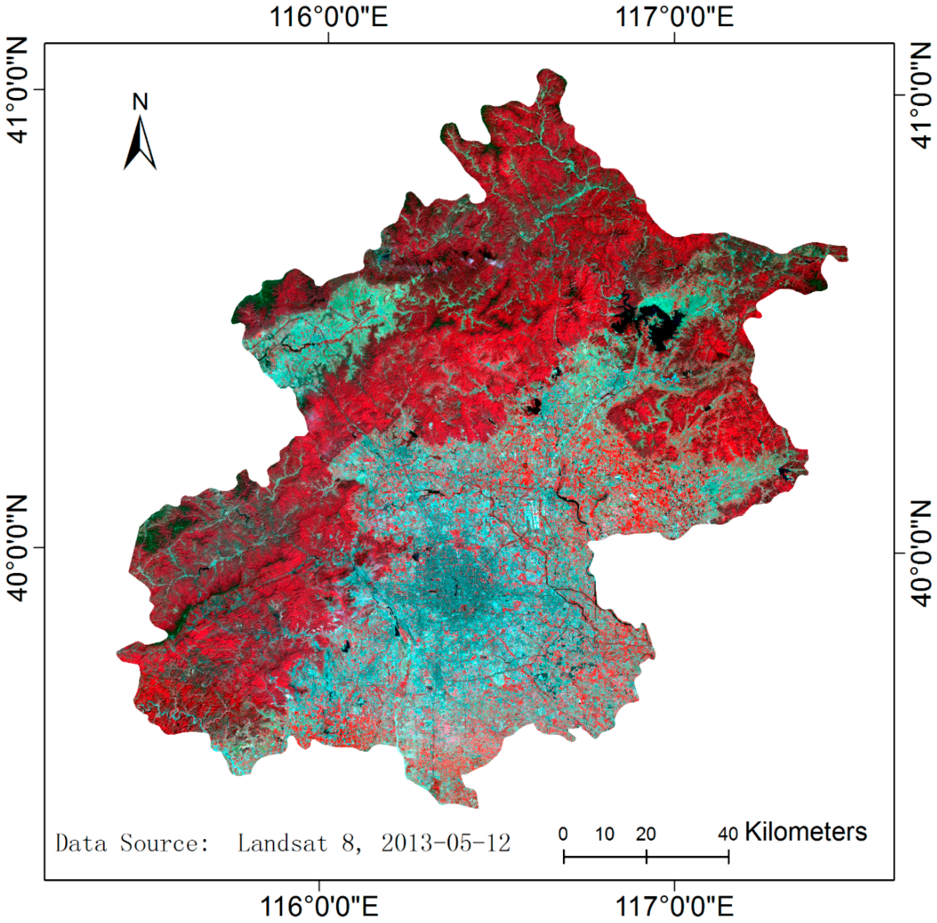
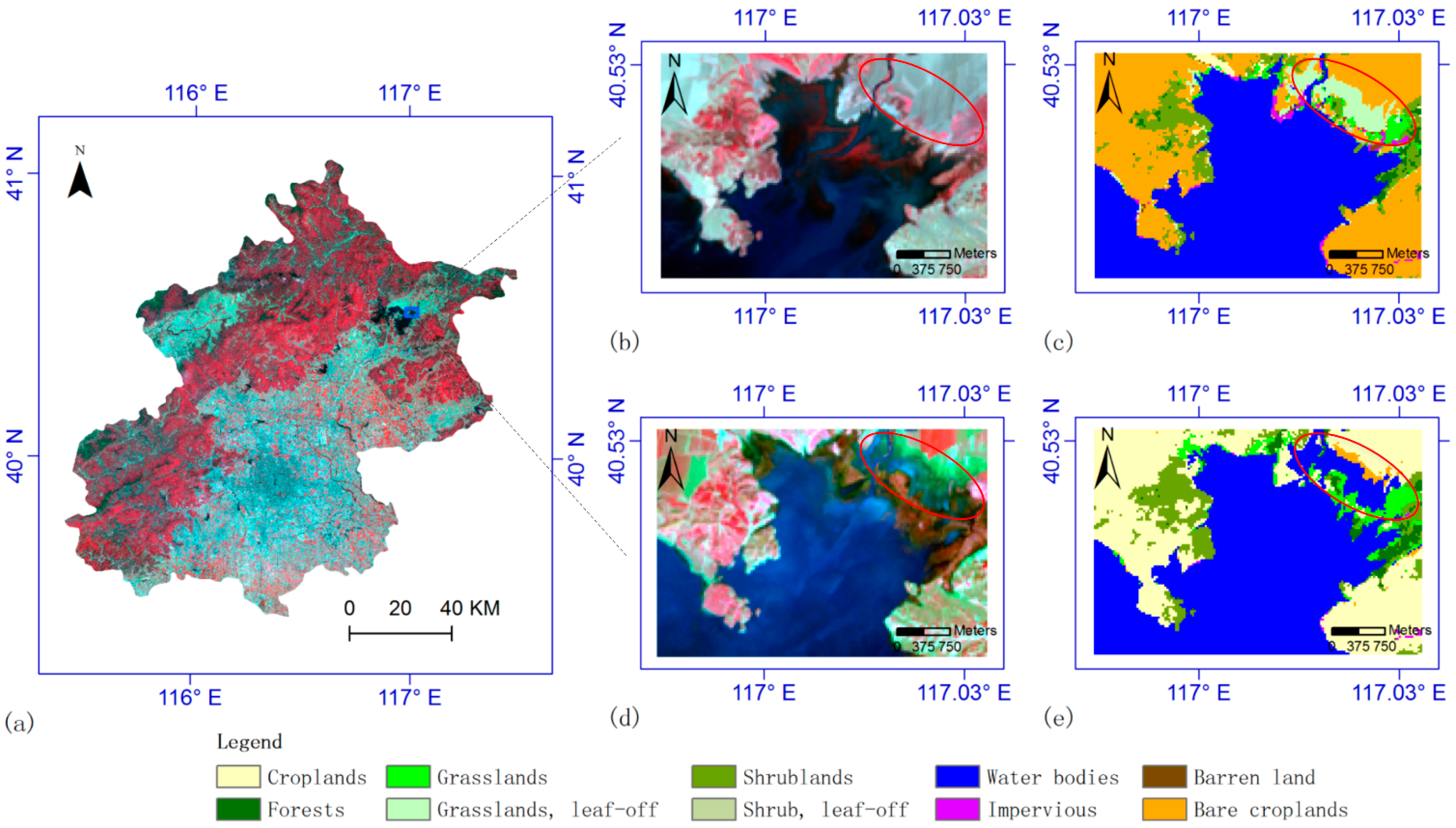
2.1. Study Area

2.2. Landsat Data

| Path-Row | DOY (the Last One Is in 2014, Others Are in 2013) | ||||||||
|---|---|---|---|---|---|---|---|---|---|
| 132 | 164 | 212 | 244 | 276 | 308 | 324 | 340 | 39 | |
| 123-32 | 0.00 | 0.12 | 0.17 | 0.02 | 0.06 | 0.01 | 0.08 | 0.21 | 0.37 |
| 123-33 | 0.01 | 0.13 | 0.53 | 0.00 | 0.12 | 0.03 | 0.36 | 0.60 | 0.58 |
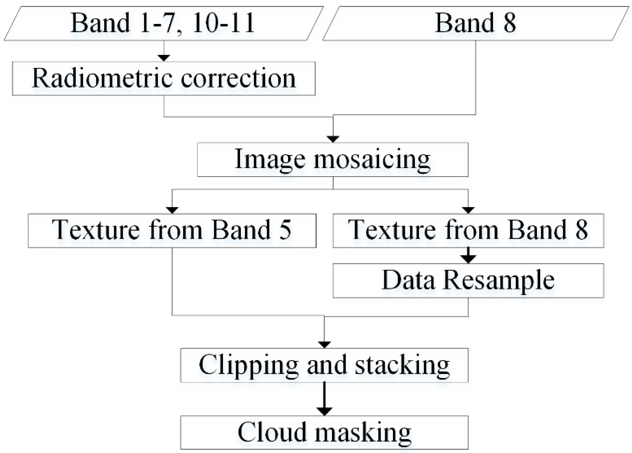
2.3. Data Preprocessing

3. Mapping Dynamic Land Cover Types
3.1. Classification System
| 1 | 2 | 3 | 4 | 5 | 6 |
| Croplands | Forests | Grasslands | Shrublands | Water bodies | Impervious |
| 7 | 8 | 9 | 10 | 11 | 12 |
| Barren lands | Snow/ice | Bare croplands | Forests, leaf-off | Grasslands, leaf-off | Shrubs, leaf-off |
3.2. Validation and Training Samples
3.3. Methodology
3.3.1. Random Forest and Markov Random Fields
3.3.2. Expanding Training Samples
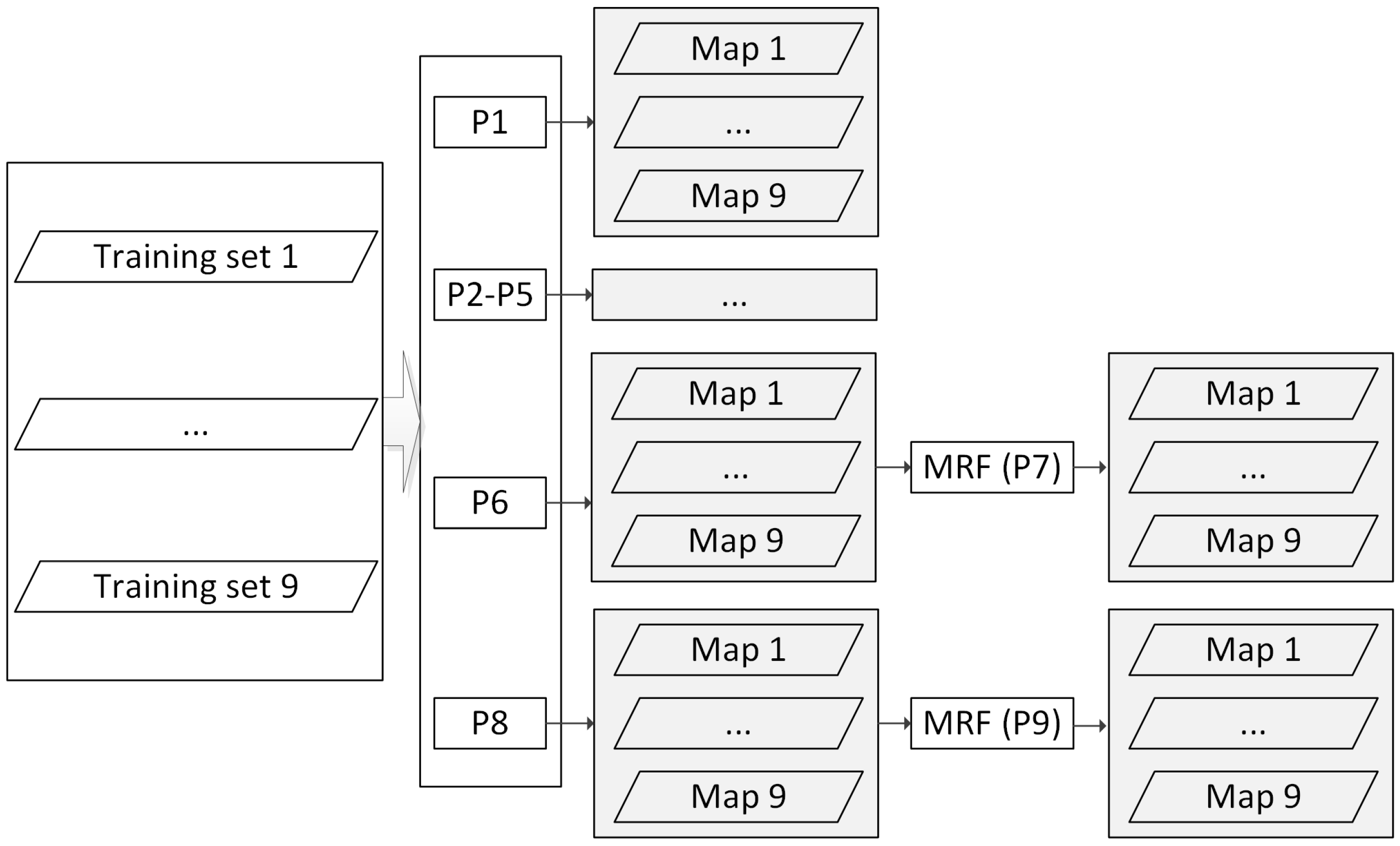
3.3.3. Classification Experiments

| Process | Features | Process | Features |
|---|---|---|---|
| P1 | OLI band 1–7 | P6 | OLI + NDVI + Textures + TIRS |
| P2 | OLI + Texture | P7 | Probabilities and map results from P6 |
| P3 | OLI + NDVI | P8 | Time series of OLI + NDVI + Textures + TIRS |
| P4 | OLI + TIRS | P9 | Probabilities and map results from P8 |
| P5 | OLI + NDVI + Texture |
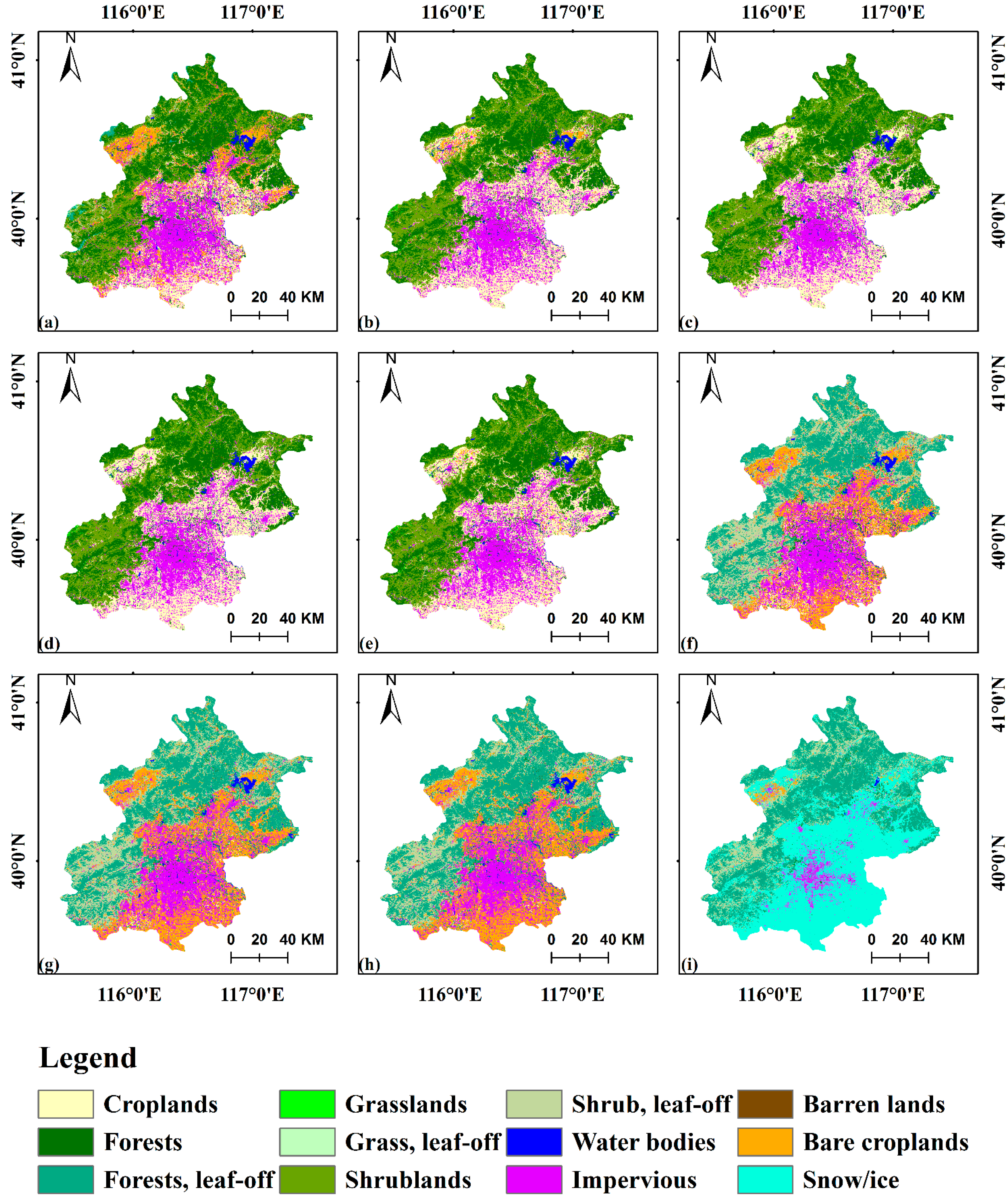
4. Results
| DOY | P1 (%) | P2 (%) | P3 (%) | P4 (%) | P5 (%) | P6 (%) | P7 (%) | P8 (%) | P9 (%) |
|---|---|---|---|---|---|---|---|---|---|
| 132 | 66.27 | 65.79 | 62.20 | 64.83 | 66.99 | 65.79 | 70.81 | 77.51 | 75.12 |
| 164 | 59.75 | 63.46 | 59.51 | 62.96 | 64.69 | 64.69 | 68.64 | 74.57 | 75.31 |
| 212 | 60.83 | 59.12 | 63.75 | 63.75 | 61.31 | 65.21 | 76.64 | 82.73 | 85.16 |
| 244 | 66.25 | 67.00 | 66.25 | 69.23 | 67.74 | 71.46 | 77.67 | 82.63 | 85.61 |
| 276 | 61.81 | 67.06 | 63.48 | 67.06 | 68.26 | 71.36 | 79.24 | 79.47 | 80.43 |
| 308 | 59.45 | 61.69 | 60.95 | 62.69 | 62.94 | 66.92 | 71.14 | 75.62 | 74.38 |
| 324 | 57.89 | 61.90 | 57.89 | 61.40 | 65.66 | 67.42 | 72.18 | 77.69 | 76.19 |
| 340 | 58.64 | 56.02 | 58.64 | 58.12 | 61.26 | 66.23 | 68.85 | 79.06 | 76.44 |
| 39 | 69.51 | 70.03 | 71.32 | 72.35 | 72.09 | 74.16 | 75.71 | 77.00 | 78.29 |
| Average | 62.27 | 63.56 | 62.67 | 64.71 | 65.66 | 68.14 | 73.43 | 78.48 | 78.55 |

| DOY | 132 | 164 | 212 | 244 | 276 | 308 | 324 | 340 | 39 | Average |
|---|---|---|---|---|---|---|---|---|---|---|
| OA(%) | 68.17 | 67.87 | 76.71 | 77.40 | 72.34 | 67.88 | 70.24 | 71.45 | 64.83 | 70.77 |
| Name | CR | BCR | FR | GR | SHR | WB | IMP | BL | UA (%) |
|---|---|---|---|---|---|---|---|---|---|
| CR | 101 | 2 | 4 | 4 | 1 | 0 | 6 | 0 | 85.59 |
| BCR | 0 | 0 | 0 | 0 | 0 | 0 | 0 | 0 | 0.00 |
| FR | 1 | 0 | 101 | 0 | 3 | 0 | 0 | 0 | 96.19 |
| GR | 0 | 0 | 0 | 0 | 0 | 0 | 0 | 0 | 0.00 |
| SHR | 7 | 0 | 23 | 0 | 68 | 0 | 0 | 0 | 69.39 |
| WB | 0 | 0 | 0 | 0 | 0 | 9 | 0 | 0 | 100.00 |
| IMP | 0 | 1 | 0 | 3 | 0 | 0 | 64 | 3 | 90.14 |
| BL | 0 | 0 | 0 | 0 | 0 | 0 | 0 | 2 | 100.00 |
| PA (%) | 92.66 | 0.00 | 78.91 | 0.00 | 94.44 | 100.00 | 91.43 | 40.00 | 85.61 |
| Name | CR | BCR | FR | FRN | SHR | SHRN | WB | IMP | OTH | UA (%) |
|---|---|---|---|---|---|---|---|---|---|---|
| CR | 10 | 14 | 0 | 0 | 0 | 0 | 0 | 0 | 4 | 35.71 |
| BCR | 9 | 64 | 1 | 0 | 0 | 0 | 0 | 2 | 3 | 81.01 |
| FR | 4 | 1 | 8 | 1 | 0 | 0 | 0 | 0 | 0 | 57.14 |
| FRN | 0 | 0 | 14 | 72 | 0 | 8 | 0 | 0 | 0 | 76.6 |
| SHR | 0 | 0 | 0 | 0 | 0 | 0 | 0 | 0 | 0 | 0 |
| SHRN | 1 | 5 | 6 | 15 | 1 | 67 | 0 | 0 | 0 | 70.53 |
| WB | 0 | 0 | 0 | 0 | 0 | 0 | 10 | 0 | 0 | 100 |
| IMP | 0 | 4 | 0 | 0 | 0 | 0 | 0 | 71 | 4 | 89.87 |
| OTH | 0 | 1 | 0 | 0 | 0 | 0 | 0 | 0 | 2 | 66.67 |
| PA (%) | 41.67 | 71.91 | 27.59 | 81.82 | 0 | 89.33 | 100 | 97.26 | 15.38 | 75.62 |
5. Discussion


6. Conclusions
Acknowledgements
Author Contributions
Conflicts of Interest
References
- Feddema, J.J.; Oleson, K.W.; Bonan, G.B.; Mearns, L.O.; Buja, L.E.; Meehl, G.A.; Washington, W.M. The importance of land-cover change in simulating future climates. Science 2005, 310, 1674–1678. [Google Scholar] [CrossRef] [PubMed]
- Moss, R.H.; Edmonds, J.A.; Hibbard, K.A.; Manning, M.R.; Rose, S.K.; van Vuuren, D.P.; Carter, T.R.; Emori, S.; Kainuma, M.; Kram, T.; et al. The next generation of scenarios for climate change research and assessment. Nature 2010, 463, 747–756. [Google Scholar] [CrossRef] [PubMed]
- Bontemps, S.; Herold, M.; Kooistra, L.; van Groenestijn, A.; Hartley, A.; Arino, O.; Moreau, I.; Defourny, P. Revisiting land cover observation to address the needs of the climate modeling community. Biogeosciences 2012, 9, 2145–2157. [Google Scholar] [CrossRef] [Green Version]
- Yang, J.; Gong, P.; Fu, R.; Zhang, M.; Chen, J.; Liang, S.; Xu, B.; Shi, J.; Dickinson, R. The role of satellite remote sensing in climate change studies. Nat. Clim. Change 2013, 3, 875–883. [Google Scholar] [CrossRef]
- Friedl, M.A.; McIver, D.K.; Hodges, J.C.F.; Zhang, X.Y.; Muchoney, D.; Strahler, A.H.; Woodcock, C.E.; Gopal, S.; Schneider, A.; Cooper, A.; et al. Global land cover mapping from MODIS: Algorithms and early results. Remote Sens. Environ. 2002, 83, 287–302. [Google Scholar] [CrossRef]
- Friedl, M.A.; Sulla-Menashe, D.; Tan, B.; Schneider, A.; Ramankutty, N.; Sibley, A.; Huang, X. MODIS Collection 5 global land cover: Algorithm refinements and characterization of new datasets. Remote Sens. Environ. 2010, 114, 168–182. [Google Scholar] [CrossRef]
- Arino, O.; Bicheron, P.; Achard, F.; Latham, J.; Witt, R.; Weber, J.L. GlobCover the Most Detailed Portrait of Earth. Available online: http://www.esa.int/esapub/bulletin/bulletin136/bul136d_arino.pdf (accessed on 16 November 2014).
- Arino, O.; Ramos, J.; Kalogirou, V.; Defourny, P.; Achard, F. Globcover 2009. In Proceedings of the Living Planet Symposium, Bergen, Norway, 28 June–2 July 2010.
- Gong, P.; Wang, J.; Yu, L.; Zhao, Y.C.; Zhao, Y.Y.; Liang, L.; Niu, Z.G.; Huang, X.M.; Fu, H.H.; Liu, S.; et al. Finer resolution observation and monitoring of global land cover: First mapping results with Landsat TM and ETM+ data. Int. J. Remote Sens. 2013, 34, 2607–2654. [Google Scholar] [CrossRef]
- Sexton, J.O.; Song, X.-P.; Feng, M.; Noojipady, P.; Anand, A.; Huang, C.; Kim, D.-H.; Collins, K.M.; Channan, S.; DiMiceli, C.; et al. Global, 30-m resolution continuous fields of tree cover: Landsat-based rescaling of MODIS vegetation continuous fields with LiDAR-based estimates of error. Int. J. Digit. Earth 2013, 6, 427–448. [Google Scholar] [CrossRef]
- Hansen, M.C.; Potapov, P.V.; Moore, R.; Hancher, M.; Turubanova, S.A.; Tyukavina, A.; Thau, D.; Stehman, S.V.; Goetz, S.J.; Loveland, T.R.; et al. High-resolution global maps of 21st-century forest cover change. Science 2013, 342, 850–853. [Google Scholar] [CrossRef] [PubMed]
- Kennedy, R.E.; Yang, Z.G.; Cohen, W.B. Detecting trends in forest disturbance and recovery using yearly Landsat time series: 1. Landtrendr—Temporal segmentation algorithms. Remote Sens. Environ. 2010, 114, 2897–2910. [Google Scholar] [CrossRef]
- Huang, C.Q.; Coward, S.N.; Masek, J.G.; Thomas, N.; Zhu, Z.L.; Vogelmann, J.E. An automated approach for reconstructing recent forest disturbance history using dense Landsat time series stacks. Remote Sens. Environ. 2010, 114, 183–198. [Google Scholar] [CrossRef]
- Sexton, J.O.; Urban, D.L.; Donohue, M.J.; Song, C.H. Long-term land cover dynamics by multi-temporal classification across the landsat-5 record. Remote Sens. Environ. 2013, 128, 246–258. [Google Scholar] [CrossRef]
- Zhu, Z.; Woodcock, C.E.; Olofsson, P. Continuous monitoring of forest disturbance using all available Landsat imagery. Remote Sens. Environ. 2012, 122, 75–91. [Google Scholar] [CrossRef]
- Zhu, Z.; Woodcock, C.E. Continuous change detection and classification of land cover using all available Landsat data. Remote Sens. Environ. 2014, 144, 152–171. [Google Scholar] [CrossRef]
- Verbesselt, J.; Hyndman, R.; Newnham, G.; Culvenor, D. Detecting trend and seasonal changes in satellite image time series. Remote Sens. Environ. 2010, 114, 106–115. [Google Scholar] [CrossRef]
- Sun, F.D.; Zhao, Y.Y.; Gong, P.; Ma, R.H.; Dai, Y.J. Monitoring dynamic changes of global land cover types: Fluctuations of major lakes in China every 8 days during 2000–2010. Chin. Sci. Bull. 2014, 59, 171–189. [Google Scholar] [CrossRef]
- Loth, B.; Graf, H.F.; Oberhuber, J.M. Snow cover model for global climate simulations. J. Geophys. Res. Atmos. 1993, 98, 10451–10464. [Google Scholar] [CrossRef]
- Roy, D.P.; Wulder, M.A.; Loveland, T.R.; Woodcock, C.E.; Allen, R.G.; Anderson, M.C.; Helder, D.; Irons, J.R.; Johnson, D.M.; Kennedy, R.; et al. Landsat-8: Science and product vision for terrestrial global change research. Remote Sens. Environ. 2014, 145, 154–172. [Google Scholar] [CrossRef]
- Rouse, J.W.; Haas, R.H.; Deering, D.W.; Schell, J.A.; Harlan, J.C. Monitoring the Vernal Advancement and Retrogradation (Green Wave Effect) of Natural Vegetation; Type III Final Report; NASA/GSFC: Greenbelt, MD, USA, 1974. [Google Scholar]
- Haralick, R.M.; Shanmuga, K.; Dinstein, I. Textural features for image classification. IEEE Syst. Man Cy. Soc. 1973, Smc3, 610–621. [Google Scholar] [CrossRef]
- Gong, P.; Marceau, D.J.; Howarth, P.J. A comparison of spatial feature-extraction algorithms for land-use classification with SPOT HRV data. Remote Sens. Environ. 1992, 40, 137–151. [Google Scholar] [CrossRef]
- Caridade, C.M.R.; Marcal, A.R.S.; Mendonca, T. The use of texture for image classification of black & white air photographs. Int. J. Remote Sens. 2008, 29, 593–607. [Google Scholar] [CrossRef]
- Breiman, L. Random forests. Mach. Learn. 2001, 45, 5–32. [Google Scholar] [CrossRef]
- Rodriguez-Galiano, V.F.; Ghimire, B.; Rogan, J.; Chica-Olmo, M.; Rigol-Sanchez, J.P. An assessment of the effectiveness of a random forest classifier for land-cover classification. ISPRS J. Photogramm. Remote Sens. 2012, 67, 93–104. [Google Scholar] [CrossRef]
- Li, C.; Wang, J.; Wang, L.; Hu, L.; Gong, P. Comparison of classification algorithms and training sample sizes in urban land classification with Landsat thematic mapper imagery. Remote Sens. 2014, 6, 964–983. [Google Scholar] [CrossRef]
- Rodriguez-Galiano, V.F.; Chica-Olmo, M.; Abarca-Hernandez, F.; Atkinson, P.M.; Jeganathan, C. Random forest classification of mediterranean land cover using multi-seasonal imagery and multi-seasonal texture. Remote Sens. Environ. 2012, 121, 93–107. [Google Scholar] [CrossRef]
- Liu, D.; Cai, S. A spatial-temporal modeling approach to reconstructing land-cover change trajectories from multi-temporal satellite imagery. Ann. Assoc. Am. Geogr. 2012, 102, 1329–1347. [Google Scholar] [CrossRef]
- Wang, J.; Zhao, Y.; Li, C.; Yu, L.; Liu, D.; Gong, P. Mapping global land cover in 2001 and 2010 with spatial-temporal consistency at 250 m resolution. ISPRS J. Photogramm. Remote Sens. 2014, in press. [Google Scholar]
- Liu, D.; Kelly, M.; Gong, P. A spatial-temporal approach to monitoring forest disease spread using multi-temporal high spatial resolution imagery. Remote Sens. Environ. 2006, 101, 167–180. [Google Scholar] [CrossRef]
- Liu, D.; Song, K.; Townshend, J.R.G.; Gong, P. Using local transition probability models in markov random fields for forest change detection. Remote Sens. Environ. 2008, 112, 2222–2231. [Google Scholar] [CrossRef]
- Besag, J. On the statistical-analysis of dirty pictures. J. Roy. Stat. Soc. B Met. 1986, 48, 259–302. [Google Scholar]
- Tuia, D.; Volpi, M.; Copa, L.; Kanevski, M.; Munoz-Mari, J. A survey of active learning algorithms for supervised remote sensing image classification. IEEE J. Sel. Top. Signal Process. 2011, 5, 606–617. [Google Scholar] [CrossRef]
- Huang, H.B.; Li, Z.; Gong, P.; Cheng, X.A.; Clinton, N.; Cao, C.X.; Ni, W.J.; Wang, L. Automated methods for measuring DBH and tree heights with a commercial scanning LiDAR. Photogramm Eng. Remote Sens. 2011, 77, 219–227. [Google Scholar] [CrossRef]
- Zhu, X.L.; Liu, D.S. Map-MRF approach to Landsat ETM plus SLC-off image classification. IEEE Trans. Geosci. Remote Sens. 2014, 52, 1131–1141. [Google Scholar] [CrossRef]
- Bolin, D.; Lindstrom, J.; Eklundh, L.; Lindgren, F. Fast estimation of spatially dependent temporal vegetation trends using gaussian markov random fields. Comput. Stat. Data Anal. 2009, 53, 2885–2896. [Google Scholar] [CrossRef] [Green Version]
© 2015 by the authors; licensee MDPI, Basel, Switzerland. This article is an open access article distributed under the terms and conditions of the Creative Commons Attribution license (http://creativecommons.org/licenses/by/4.0/).
Share and Cite
Wang, J.; Li, C.; Hu, L.; Zhao, Y.; Huang, H.; Gong, P. Seasonal Land Cover Dynamics in Beijing Derived from Landsat 8 Data Using a Spatio-Temporal Contextual Approach. Remote Sens. 2015, 7, 865-881. https://0-doi-org.brum.beds.ac.uk/10.3390/rs70100865
Wang J, Li C, Hu L, Zhao Y, Huang H, Gong P. Seasonal Land Cover Dynamics in Beijing Derived from Landsat 8 Data Using a Spatio-Temporal Contextual Approach. Remote Sensing. 2015; 7(1):865-881. https://0-doi-org.brum.beds.ac.uk/10.3390/rs70100865
Chicago/Turabian StyleWang, Jie, Congcong Li, Luanyun Hu, Yuanyuan Zhao, Huabing Huang, and Peng Gong. 2015. "Seasonal Land Cover Dynamics in Beijing Derived from Landsat 8 Data Using a Spatio-Temporal Contextual Approach" Remote Sensing 7, no. 1: 865-881. https://0-doi-org.brum.beds.ac.uk/10.3390/rs70100865