1. Introduction
Due to the importance of land surface albedo, in recent years a great deal of research has been carried out on obtaining land surface albedo at moderate to low scales of spatio-temporal resolution by using several types of remote sensing data obtained from different sensors [
1,
2,
3,
4,
5,
6]. However, the low spatio-temporal resolution of these albedo data restricts the high-frequency monitoring of land surface changes caused by natural and social events operating at local scales. Thus, retrieval of land surface albedo with better spatio-temporal resolution has been a subject of increasing research attention, and a number of related studies have been conducted. Liang
et al. made use of radiative transfer simulation to construct the empirical relation between reflectance and albedo based on a land cover spectral library [
7,
8]. Recently, an improved empirical algorithm introduced the Polarization and Directionality of Earth’s Reflectances Bidirectional Reflectance Distribution Function (BRDF) as prior knowledge to consider land surface reflective anisotropy [
9]; using this method, topographic effects have been considered [
10]. Additionally, Shuai
et al. (2011) fused Landsat 5 30-m reflectance and MODerate Resolution Imaging Spectroradiometer (MODIS) BRDF at 500-m resolution to retrieve 30-m LANDSAT albedo for a snow-free area [
11]. Franch
et al. (2014) proposed a method to derive the Landsat surface albedo using known BRDF parameters from the MODIS Climate Modeling Grid product using the VJB method [
12]. Another study retrieving daily MODIS land surface albedo based on the improved VJB method was performed by Franch
et al. (2014) [
12,
13]. In addition, some research has focused on fusing albedo products to improve the spatio-temporal resolution [
14]. These studies improved only the spatial or the temporal resolution of albedo. To acquire albedo data with better spatio-temporal resolution, our previous work combined the reflectance observed by HJ-1A/B at a spatio-temporal resolution of 30 m and 2–4 days with MODIS BRDF at a spatio-temporal resolution of 8 days and 500 m to obtain albedo data at a spatio-temporal resolution of 30 m and 2–4 days [
15]. Compared to other previous studies, that work retrieved albedo data with an improved spatio-temporal resolution, however, the albedo spatio-temporal resolution was still limited by the spatio-temporal resolution of the HJ-1A/B data used. All of these studies retrieved an image of albedo based on an image of reflectance using the assumption that the BRDF of a single land cover classification is stable.
In general, the spatio-temporal resolution of the albedo data retrieved by the above methods is restricted by the spatio-temporal resolution of the input reflectance data. Improvements to the spatio-temporal resolution of albedo are limited unless reflectance data with better spatio-temporal resolution can be obtained. Downscaling technology provides an opportunity for acquiring reflectance data with better spatio-temporal resolution.
Recently, downscaling of remote sensing data has been the focus of many research studies, particularly for coarse-resolution satellite data [
16]. These include studies of precipitation [
17,
18,
19,
20], soil moisture [
20,
21], and land surface temperature [
22,
23]. Sorooshian
et al. (2011) demonstrated the use of downscaling as a key technology in the application of satellite data [
24]. For downscaling land surface reflectance, Gao
et al. (2006) proposed a spatial and temporal adaptive reflectance fusion model (STARFM) which fuses MODIS reflectance and Landsat reflectance to predict daily Landsat reflectance by considering spectral weight, distance weight, and temporal weight [
25]. Enhanced STARFM was used to improve the algorithm for predicting daily Landsat reflectance in heterogeneous regions based on STARFM. Song and Huang (2013) combined MODIS data and Landsat data by using high-pass modulation [
26].
The method of downscaling reflectance (e.g., Gao and Song methods) and the empirical method of retrieving albedo (e.g., Shuai and Franch methods) have not yet been combined to obtain an albedo product with higher spatial and higher temporal resolution than the currently available albedo products [
11,
12,
25,
26]. To address this issue, this study describes a new method to retrieve daily land surface albedo from space at 30-m resolution by fusing HJ-1A/B and MODIS. The proposed method first downscales Terra MODIS reflectance (MOD09GA) to HJ-1A/B spatial resolution based on HJ-1A/B BRDF, which includes corrections for illuminating and viewing geometry. Thus, albedo data with higher spatio-temporal resolution are retrieved by downscaled reflectance, which is similar to Shuai’s method. Compared to other methods of downscaling reflectance, the proposed method possesses two improvements. Firstly, the proposed method initially converts reflectance from narrowband to shortwave broadband (NTOB) for the MODIS and HJ-1A/B data, which theoretically eliminates the error from the band mismatch between MODIS and HJ-1A/B. Secondly, an empirical relation is constructed between MODIS reflectance and HJ-1A/B reflectance with the same illuminating and viewing geometry as MODIS based on HJ-1A/B BRDF, which effectively eliminates the error resulting from illuminating and viewing geometry mismatches between MODIS and HJ-1A/B. The proposed method also has several differences from the Shuai and Franch methods [
11,
12] for retrieving albedo: firstly, pre-processing of the NTOB reflectance of MODIS and HJ-1A/B data effectively corrects the error resulting from band mismatch between sensors; secondly, the proposed method combines the methods of downscaling reflectance and retrieving albedo based on prior knowledge and, thus, can retrieve albedo data with better spatio-temporal resolution than the Shuai or Franch methods.
Using the empirical method from Shuai’s work, we use downscaled land surface reflectance and MODIS BRDF data to derive the daily 30-m land surface albedo.
Section 2 and
Section 3 introduce the theoretical basis of and describe the procedure for deriving daily 30-m albedo based on downscaled reflectance data and prior MODIS BRDF.
Section 4 provides an overview of the study area and experimental data.
Section 5 validates these results and describes the evaluation of accuracy.
Section 6 lists the conclusions and outlines the disadvantages of the proposed method.
3. Method
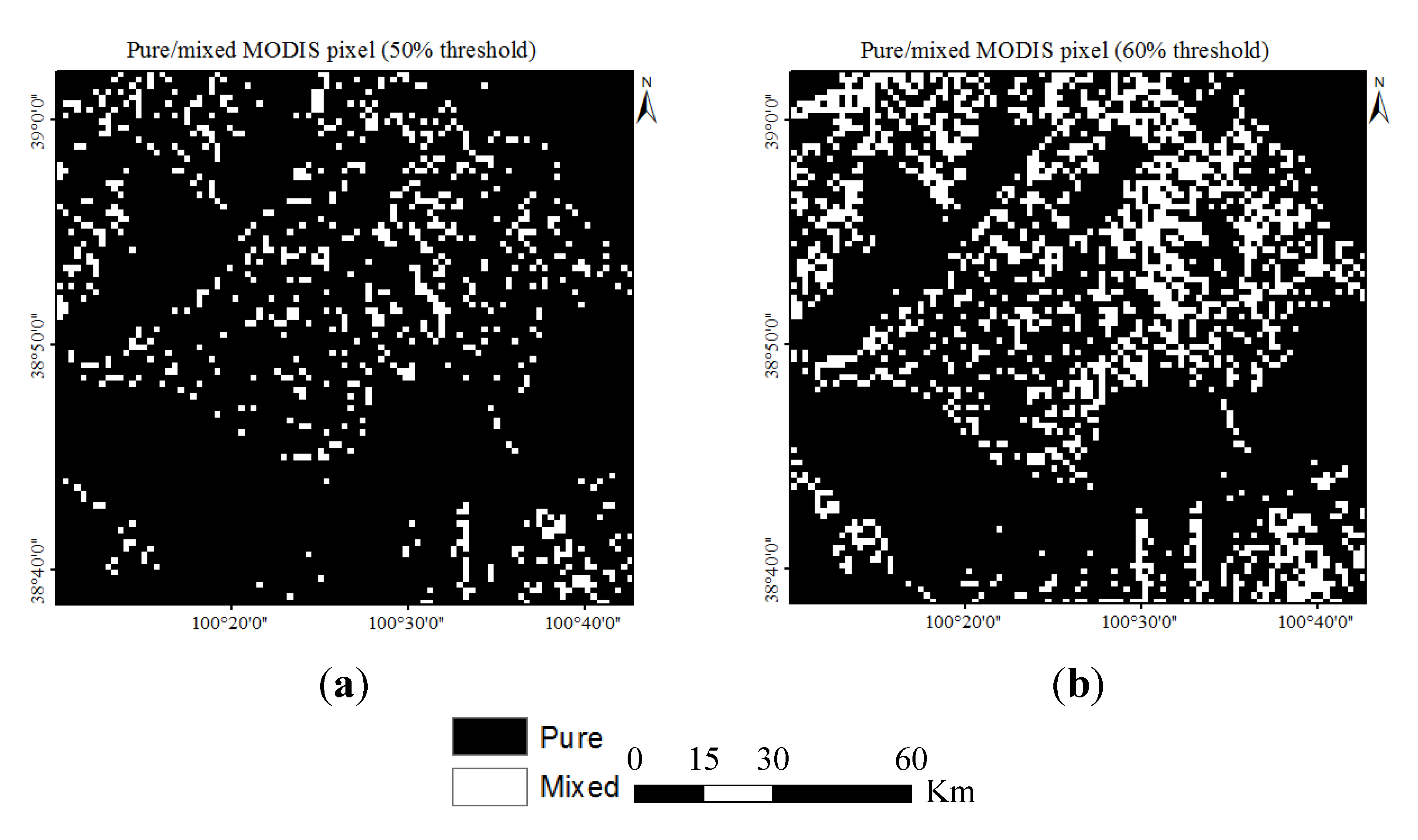
Based on
Section 2.1, downscaling land surface reflectance by fusing MODIS and HJ-1A/B data ensures that daily 30-m land surface reflectance for use as input data can be acquired after atmospheric correction and the conversion of narrowband to broadband (NTOB) shortwave surface reflectance [
7,
19,
30,
31]. Then, incorporating the classification of MODIS pixels as pure or mixed, two empirical methods were adopted to combine the downscaled reflectance and MODIS BRDF and, thus, retrieve daily 30-m albedo data [
15]. Within the MODIS pure pixel, the albedo is first derived based on the downscaled reflectance and MODIS BRDF; the derived albedo and the corresponding downscaled reflectance are introduced into a lookup table (LUT) to construct the ratio of the downscaled reflectance and albedo to be derived in the MODIS mixed pixel. From HJ-1A/B 30-m land cover data, some classifications occupy more or less than 60% of a MODIS 500-m pixel, these MODIS pixels are regarded as pure or mixed pixels, respectively. In our previous study [
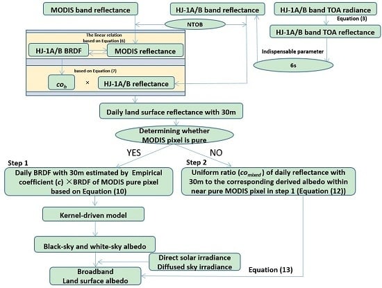
15], a specific discussion of the thresholds was carried out to demonstrate that 60% is a reasonable threshold value. A flowchart for data retrieval is provided in
Figure 1.
Figure 1.
Flowchart describing retrieval of daily 30-m land surface albedo data.
Figure 1.
Flowchart describing retrieval of daily 30-m land surface albedo data.
3.1. NTOB Reflectance
For HJ-1A/B observations at the top of the atmosphere (TOA), an atmospheric correction must be performed based on Second Simulation of a Satellite Signal in the Solar Spectrum (6S). Due to the lack of information on corresponding atmospheric parameters (e.g., aerosol optical depth and water vapor), cloud masking is initially carried out using the four band thresholds of HJ-1A/B based on the prior knowledge, to ensure that the reflectance at TOA with no cloud was selected for further processing. Subsequently, 6S runs were carried out based on the HJ-1A/B parameters (e.g., spectral response function and illuminating and viewing geometry) and the empirical atmospheric parameters for the atmospheric correction for HJ-1A/B band reflectance.
After atmospheric correction, the spectral difference of data from different sensors must be considered. Spectral difference hinders fusing of data of different sensors, which could introduce errors in the course of multi-source application. Thus, the reflectance of different sensors must be normalized before running the algorithm to retrieve albedo.
Table 1 shows the spectral differences between MODIS and HJ-1A/B.
Table 1.
Spectral distributions of MODIS and HJ-1A/B CCD.
Table 1.
Spectral distributions of MODIS and HJ-1A/B CCD.
| Band | 1 (nm) | 2 (nm) | 3 (nm) | 4 (nm) | 5 (nm) | 6 (nm) | 7 (nm) |
|---|
| MODIS | 620–670 | 841–876 | 459–479 | 545–565 | 1230–1250 | 1628–1652 | 2105–2155 |
| HJ-1A/B | 430–520 | 520–600 | 630–690 | 760–900 | - | - | - |
Considering the spectral range of a sensor, it is possible to obtain the shortwave albedo from the band albedo:
where
wl is the band weight and
l is the number of bands.
Table 2 and
Table 3 list the weights used to convert band to shortwave albedo for HJ-1A/B data. In MODIS official products (MCD43B1), the shortwave BRDF/albedo can be calculated by weighting the band BRDF/albedo using the weights for converting band albedo to shortwave albedo. Thus, in this study, the weights converting HJ-1 band albedo to shortwave albedo are used for converting HJ-1 band reflectance to shortwave reflectance (
Table 2); the weights for NTOB MODIS are used for NTOB MODIS reflectance (
Table 3).
Table 2.
Weights used for NTOB HJ-1 reflectance (referencing to Liu (2012)) [
32].
Table 2.
Weights used for NTOB HJ-1 reflectance (referencing to Liu (2012)) [32].
| Band | 1 | 2 | 3 | 4 |
|---|
| HJ1ACCD1 | −0.5878 | 0.6543 | 0.4183 | 0.3891 |
| HJ1ACCD2 | −0.5138 | 0.5175 | 0.4838 | 0.3865 |
| HJ1BCCD1 | −0.6066 | 0.6175 | 0.4703 | 0.3925 |
| HJ1BCCD2 | −0.5149 | 0.5403 | 0.4592 | 0.3898 |
Table 3.
Weights used for NTOB MODIS reflectance (referencing to Liang
et al. (1999)) [
7].
Table 3.
Weights used for NTOB MODIS reflectance (referencing to Liang et al. (1999)) [7].
| Band | 1 | 2 | 3 | 4 | 5 | 6 | 7 | Const |
|---|
| MODIS | 0.3973 | 0.2382 | 0.3489 | −0.2655 | 0.1604 | −0.0138 | 0.0682 | 0.0036 |
3.2. Downscaling Reflectance by Fusing MODIS and HJ-1A/B Data
The spatio-temporal resolution of the derived albedo depends on the resolution of the remote sensing data that are used for obtaining the albedo. The intended use of the proposed method is to derive the daily 30-m land surface albedo, which requires information about the daily 30-m land surface reflectance. However, current remote sensing products do not possess 30-m spatial resolution and 1-day temporal resolution. Thus, obtaining daily 30-m land surface reflectance is essential for the proposed method. The proposed method solves this problem by fusing high-scale spatial data (HJ-1A/B reflectance) and high-scale temporal data (MODIS reflectance) to downscale land surface reflectance.
We assume that land use type is unchanged over an 8-day period. The unchanged land use means that the BRDF shape of the land surface is unchanged, and the BRDF for a single location shows only a shift in magnitude over an 8-day period. Therefore, there must be one image of the HJ-1A/B reflectance
Rhj/BRDF
BRDFhj that is the closest time and location to each image of MODIS reflectance
Rmodis over an 8-day period. For each MODIS reflectance image, the corresponding HJ-1A/B BRDF at 30 m is used to calculate the HJ-1A/B reflectance with the same illuminating and viewing geometry as the corresponding MODIS based on Equation (5). Subsequently, within a MODIS pixel, a coefficient is calculated that is the ratio of the MODIS reflectance to the average value of the corresponding HJ-1A/B reflectance derived from HJ-1A/B BRDF: this coefficient has the same spatio-temporal resolution as the MODIS reflectance (based on Equation (6)). The daily 30-m land surface reflectance
Rh is calculated from the coefficient multiplied by the corresponding reflectance (Equation (7)). The equation for
Rh is:
where
Rmodis is the reflectance observed by MODIS at the illuminating and viewing geometry (θ
i, θ
vmodis, Фvmodis, Фi, Tmodis);
BRDFhj is the known HJ-1A/B BRDF in the 30-m subpixel of
Rmodis;
thj is the time when
Rhj is obtained;
Tmodis is the time when
Rmodis is observed and
n denotes the number of HJ-1A/B pixels within the MODIS pixel.
3.3. Retrieving Daily 30-m Land Surface Albedo for Pure MODIS Pixels
Within a MODIS pure pixel, the MODIS BRDF parameters and the downscaled daily 30-m land surface reflectance have the same land surface reflective distribution shape, except for some shifts in magnitude caused by the optical differences between the products from different sensors over the 8-day measurement period (the temporal resolution of the MODIS BRDF product). Within one MODIS pixel, the MODIS BRDF provides the BRDF shape of every 30-m pixel during these eight days, but cannot provide information on the magnitude of the shift. Thus, for a HJ-1A/B pixel within a pure MODIS pixel, the fitted linear relation between the MODIS BRDF and the daily land surface BRDF in the pixel is given by Equation (10):
where
Rh is the downscaled daily 30-m land surface reflectance;
BRDFm is the calculated reflectance that is the value of the MODIS BRDF at (θ
i, θ
vh,
Фvh,
Фi) and is the same as
Rh;
Tm indicates the 8-day period of the MODIS BRDF product and
th is the frequency of HJ-1A/B observations during
Tm. Thus, the daily 30-m BRDF can be calculated using the following equation:
After the daily BRDF for each 30-m pixel has been retrieved, BRDFh is integrated to derive the daily 30-m albedo on the basis of Equation (1).
3.4. Retrieving the Daily 30-m Land Surface Albedo for Mixed MODIS Pixels
The LUT is constructed on the basis of retrieved daily 30-m albedo data and the corresponding downscaled daily 30-m reflectance data within the pure MODIS pixel, which is used for deriving the daily 30-m albedo within mixed MODIS pixels. For every 30-m pixel in a mixed MODIS pixel, a window (3 × 3 km) is delimited around the 30-m pixel, and all retrieved values of the albedo and the corresponding reflectance of the 30-m pixels with the same land cover as the target 30-m pixel in this image subset are extracted to construct the LUT. In the LUT, every pair of values for retrieved albedo and corresponding land surface reflectance can be assigned a ratio,
con, from Liang
et al. [
8].
For eliminating error from a singular value, averaging all
con in LUT can provide a uniform ratio
comixed:
As the daily 30-m reflectance
rhj and the corresponding
comixed are known, the albedo
Albedo_HJ for a 30-m pixel within a mixed MODIS pixel is:
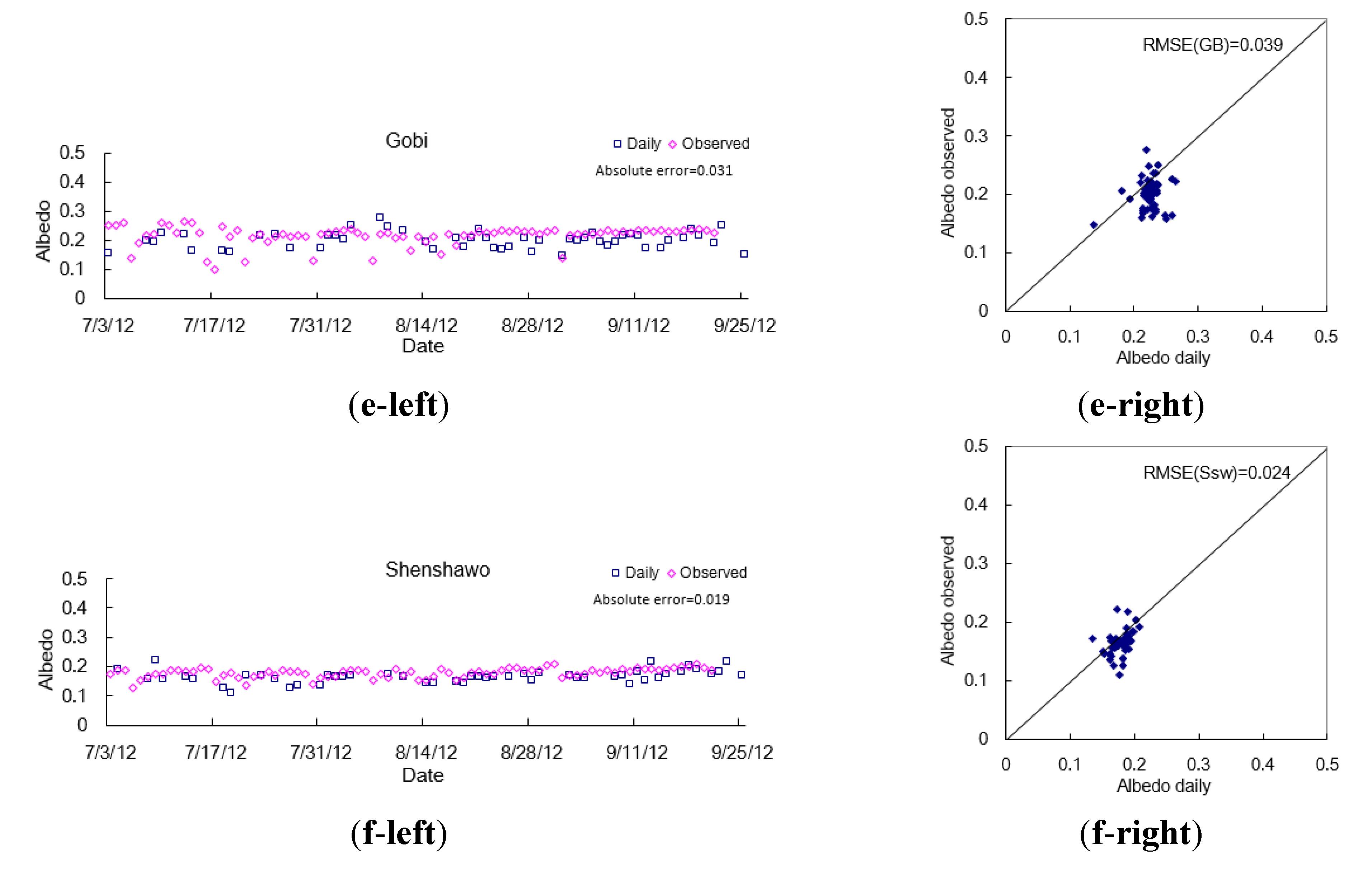
6. Conclusions
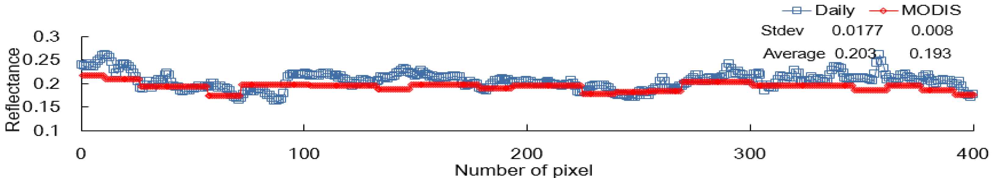
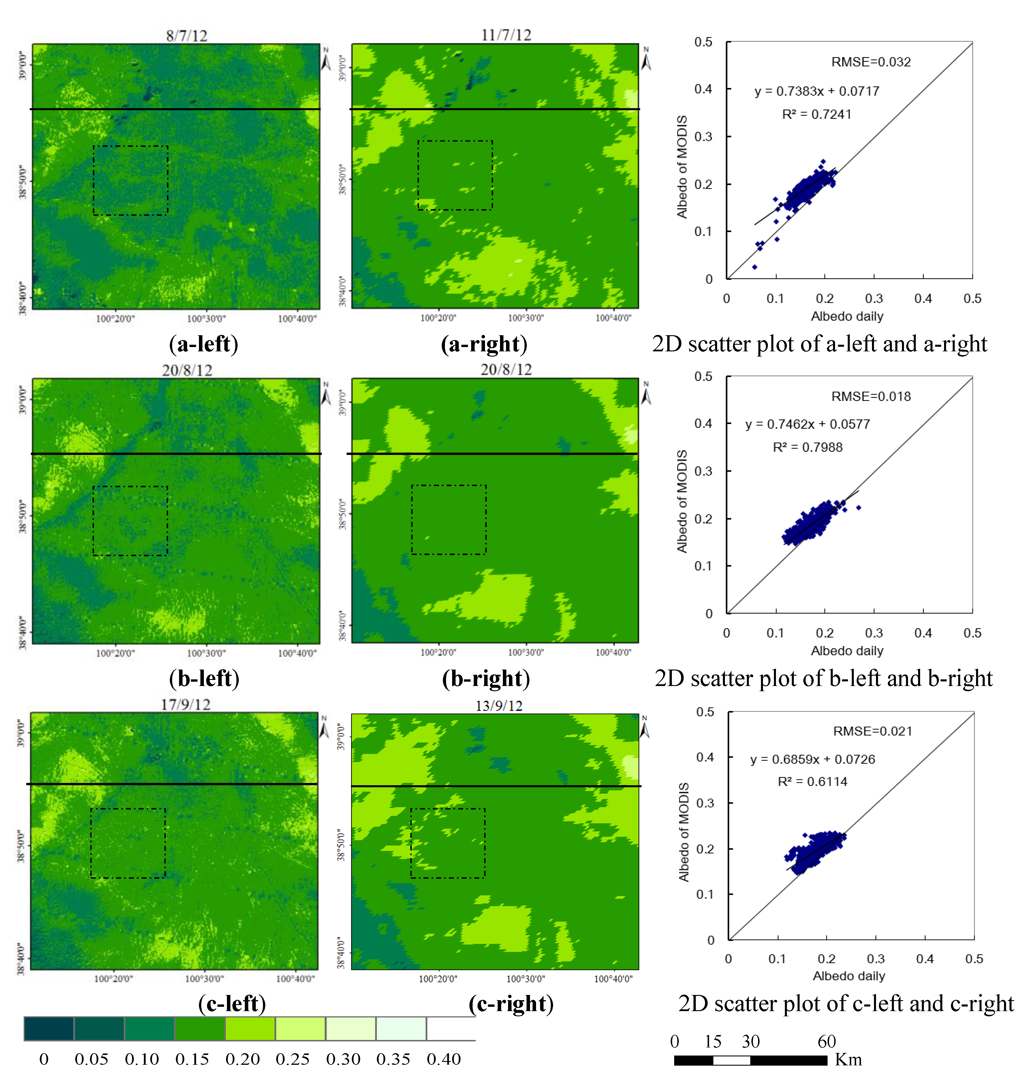
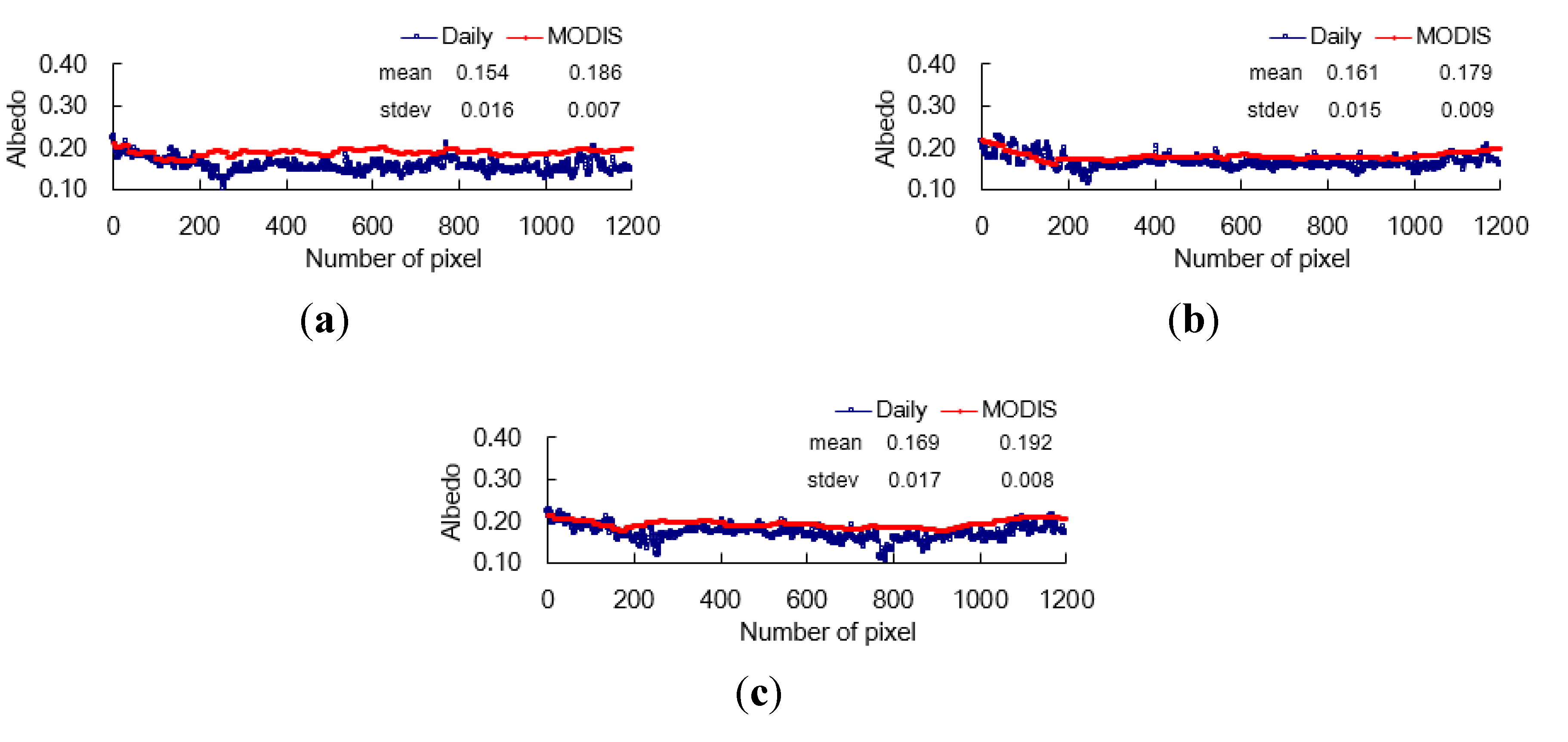
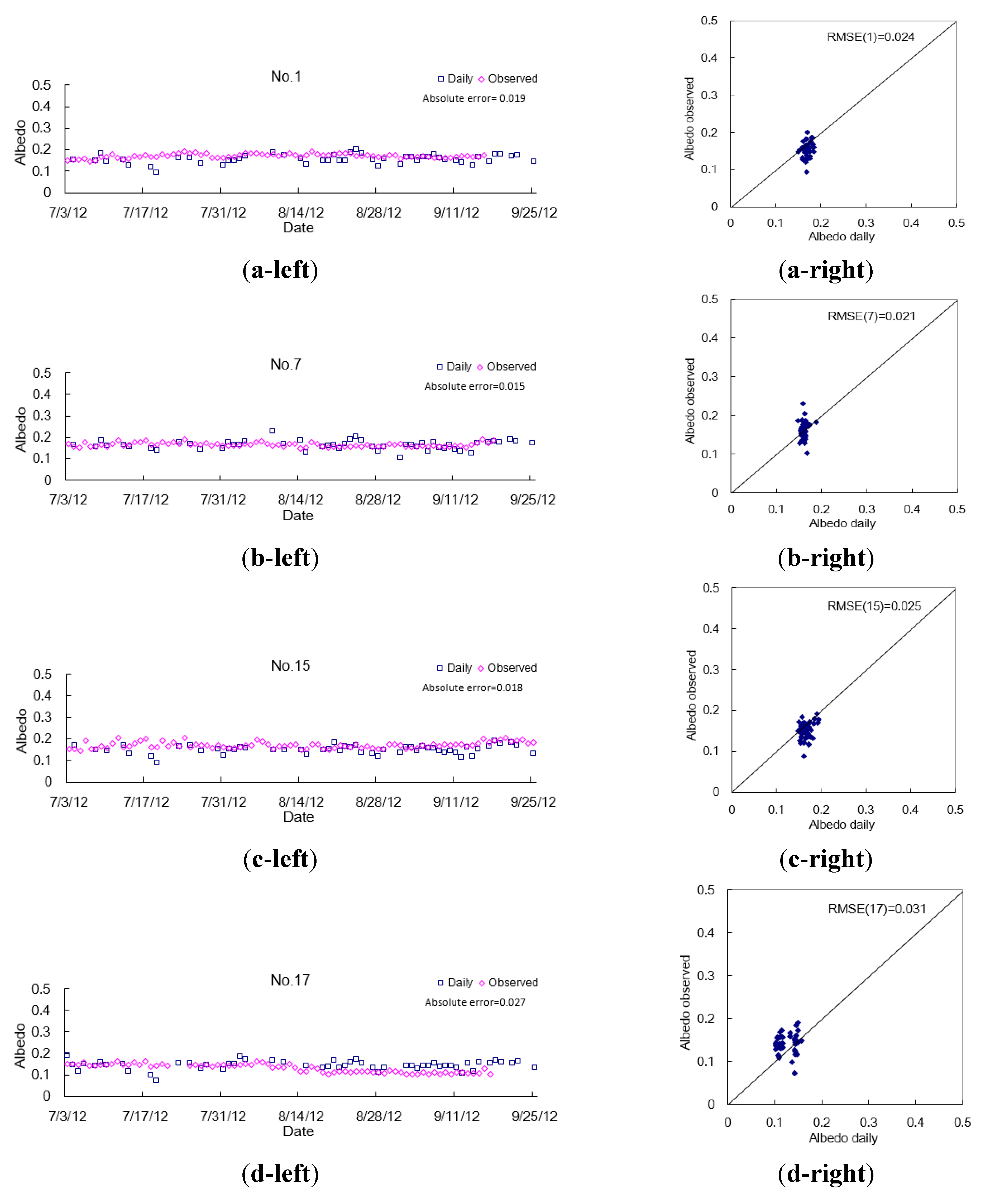
The proposed algorithm makes use of downscaling technology to acquire daily 30-m land surface reflectance with good spatio-temporal resolution that cannot be acquired by any single-sensor observation. The downscaled daily 30-m land surface reflectance and MODIS BRDF data are combined empirically to first derive the daily 30-m land surface albedo. The proposed method of albedo retrieval first introduces the downscaling technology and the idea of data fusion, and improves the retrieval accuracy and the spatio-temporal resolution of albedo data. The accuracy of the derived daily 30-m albedo is comparable to or better than those of existing methods and has better spatio-temporal resolution than the currently available data. The newly developed method is of practical use and is, thus, likely to be adopted. In general, the proposed method combines downscaling of reflectance and empirical retrieval albedo, which provides albedo data with a reasonable precision and a higher spatio-temporal resolution than other methods.
Although the proposed method effectively improves the spatio-temporal resolution and accuracy of albedo, there are still some deficiencies. As well as inaccurate atmospheric correction caused by a lack of, and inaccuracy in, atmospheric parameters (e.g., aerosol optical depth and water vapour), uncertainties due to the temporal-scale mismatch of the MODIS BRDF (8-day scale) and HJ data (2–4-day scale) may introduce error. In the course of downscaling the land surface reflectance, HJ-1A/B BRDF and reflectance data may not capture the variation of land cover for every day because of the 2–4-day temporal resolution, but the daily MODIS reflectance can achieve this. When natural and social emergencies occur, albedo may change rapidly. In this situation, the HJ-1A/B and MODIS information may be inconsistent, possibly causing errors.
In conclusion, the proposed method first retrieves the daily albedo at 30 m, but some work needs to be done to further improve the proposed method in the future; one is how to acquire the atmospheric parameters corresponding to the HJ-1A/B data for atmospheric correction; another one is how to eliminate the error from the temporal mismatch among the multisource data (e.g., HJ-1A/B data, MODIS reflectance, MODIS BRDF).


