Assessing Mismatches in the Provision of Urban Ecosystem Services to Support Spatial Planning: A Case Study on Recreation and Food Supply in Havana, Cuba


Abstract
:1. Introduction
2. Case Study Area and Selected Ecosystem Services
3. Materials and Methods
3.1. Mapping Service Providing and Service Demanding Areas
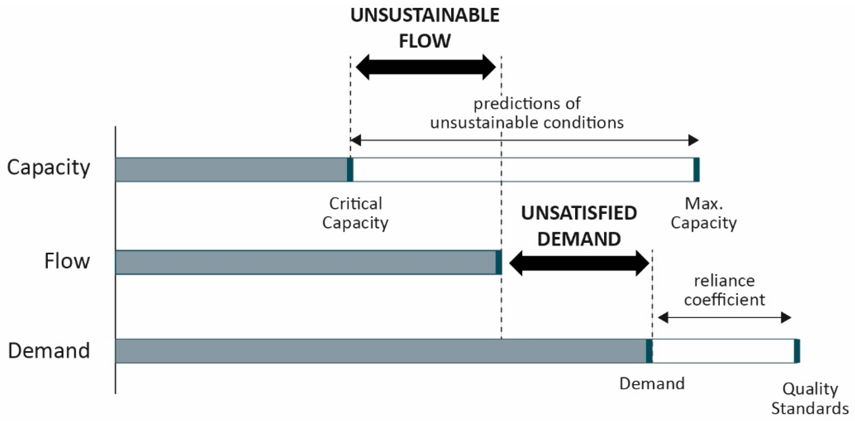
3.2. Quantifying and Mapping “Unsustainable Flow” and “Unsatisfied Demand” Mismatches
4. Results
4.1. Service Providing and Service Demanding Areas
4.2. Quantifying and Mapping Mismatches
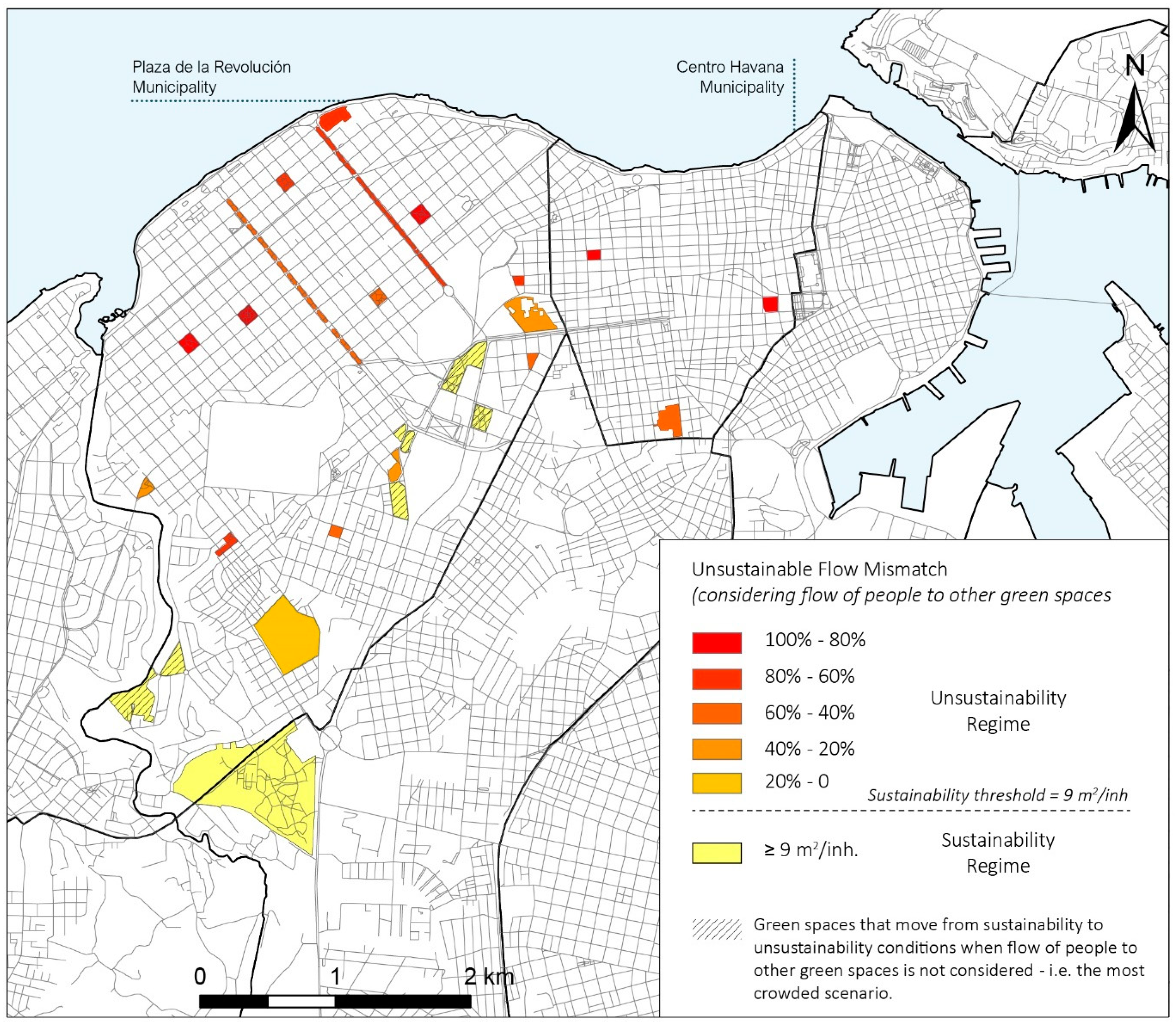
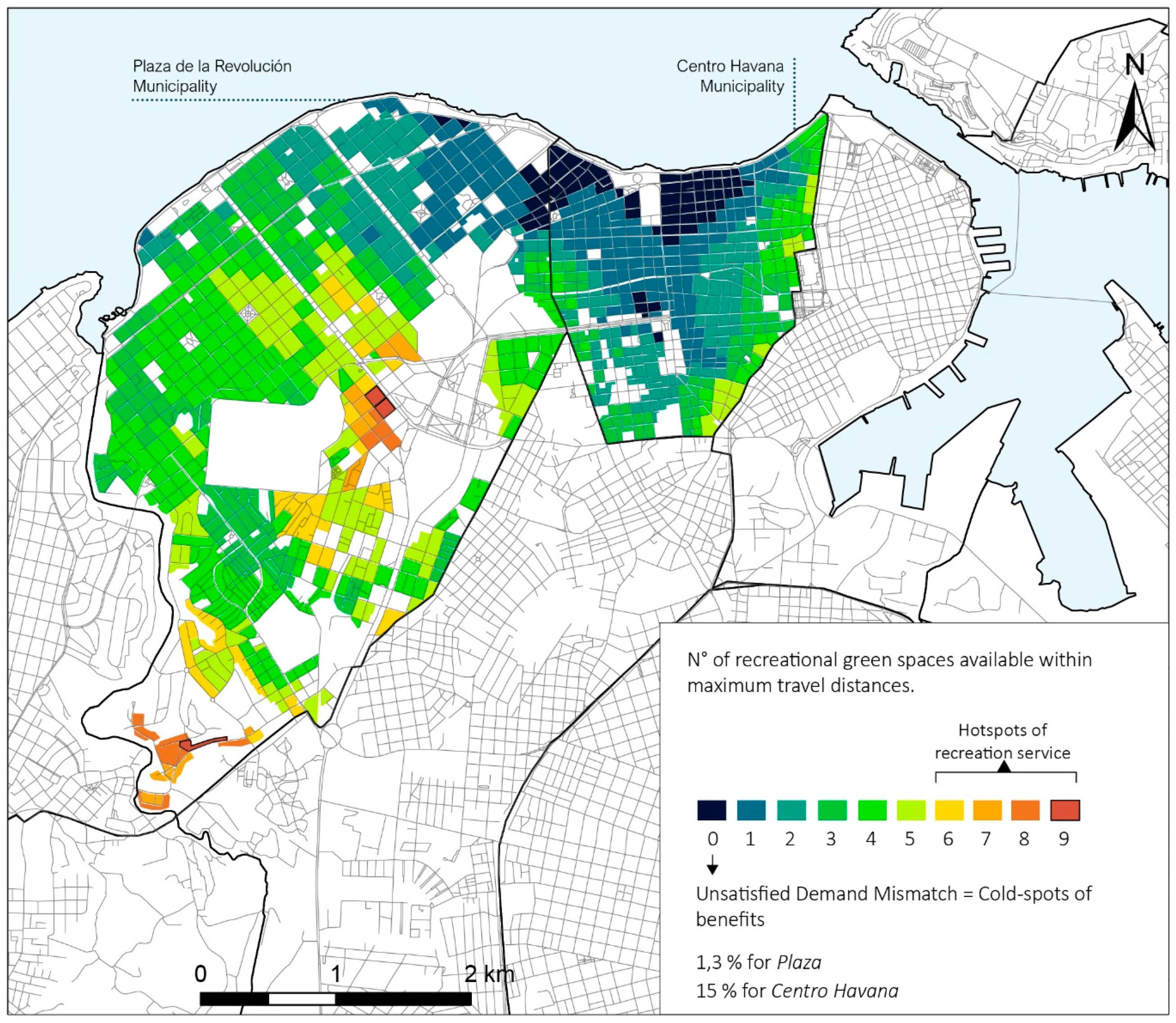
4.2.1. Recreation
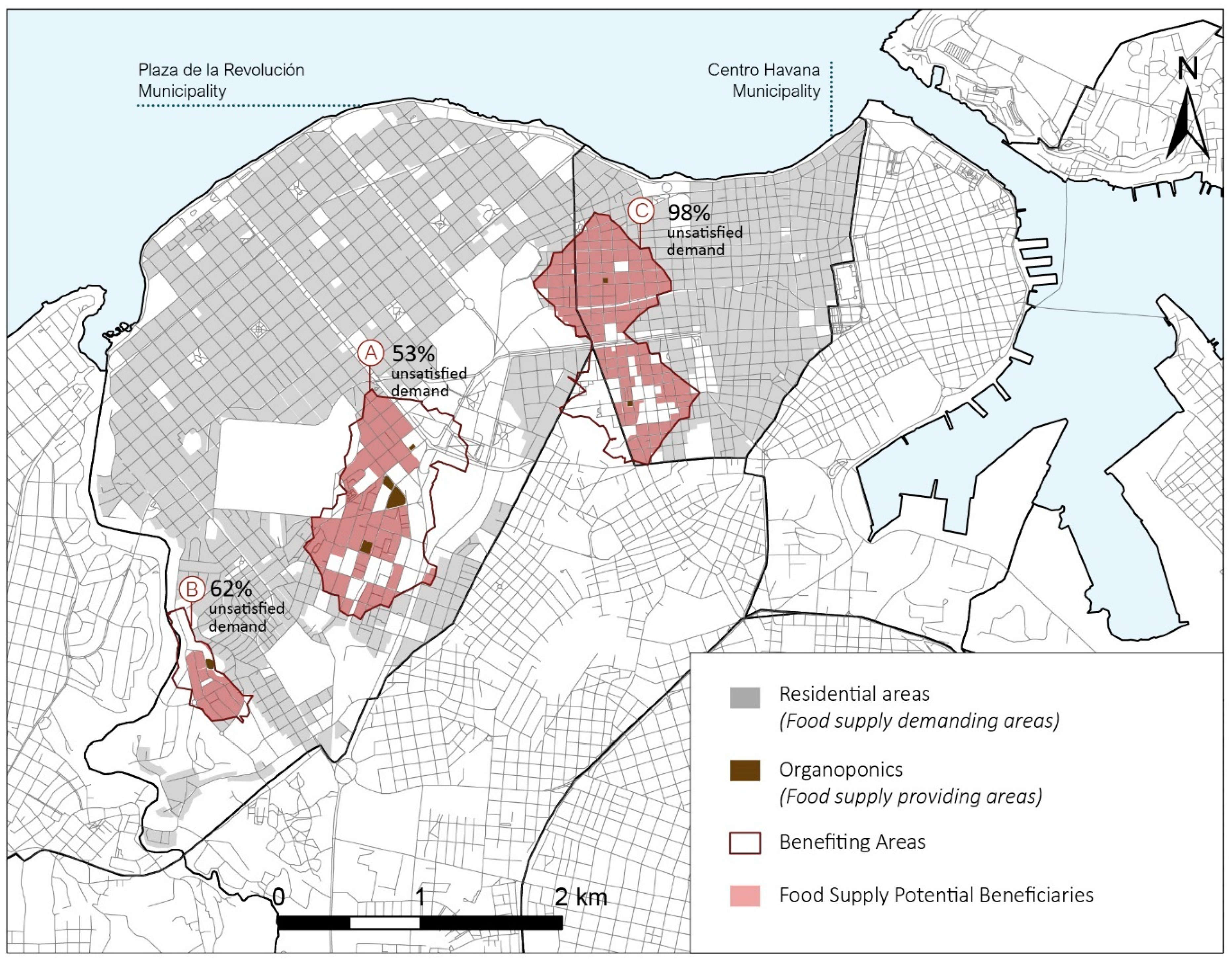
4.2.2. Food Supply
5. Discussion
5.1. Unsustainable Flow and Unsatisfied Demand Mismatches in the Case Study
5.2. Challenges of Assesing Mismatches and Insights for Future Research
5.3. How Can Mismatch Assessment Support Spatial Planning?
6. Conclusions
Author Contributions
Funding
Acknowledgments
Conflicts of Interest
References
- Daily, G.C. Nature’s Services: Societal Dependence on Natural Ecosystems; Island Press: Washington, DC, USA, 1997. [Google Scholar]
- Haines-Young, R.; Potschin, M. The links between biodiversity, ecosystem services and human well-being. In Ecosystem Ecology: A New Synthesis; Cambridge University Press: Cambridge, UK, 2010; pp. 110–139. ISBN 9780511750458. [Google Scholar]
- Burkhard, B.; Kandziora, M.; Hou, Y.; Müller, F. Ecosystem service potentials, flows and demands-concepts for spatial localisation, indication and quantification. Landsc. Online 2014, 34, 1–32. [Google Scholar] [CrossRef]
- Boyd, J.; Banzhaf, S. What are ecosystem services? The need for standardized environmental accounting units. Ecol. Econ. 2007, 63, 616–626. [Google Scholar] [CrossRef]
- Elmqvist, T.; Fragkias, M.; Goodness, J.; Güneralp, B.; Marcotullio, P.J.; McDonald, R.I.; Parnell, S.; Schewenius, M.; Sendstad, M.; Seto, K.C.; et al. Urbanization, Biodiversity and Ecosystem Services: Challenges and Opportunities; Springer: Dordrecht, The Netherlands, 2013; ISBN 9789400770874. [Google Scholar]
- Gómez-Baggethun, E.; Barton, D.N. Classifying and valuing ecosystem services for urban planning. Ecol. Econ. 2013, 86, 235–245. [Google Scholar] [CrossRef]
- Luederitz, C.; Brink, E.; Gralla, F.; Hermelingmeier, V.; Meyer, M.; Niven, L.; Panzer, L.; Partelow, S.; Rau, A.L.; Sasaki, R.; et al. A review of urban ecosystem services: Six key challenges for future research. Ecosyst. Serv. 2015, 14, 98–112. [Google Scholar] [CrossRef]
- Cvejić, R.; Eler, K.; Pintar, M.; Železnikar, Š.; Haase, D.; Kabisch, N.; Strohbach, M. A Typology of Urban Green Spaces, Eco-System Services Provisioning Services and Demands. 2015. Available online: https://greensurge.eu/workingpackages/wp3/files/D3.1_Typology_of_urban_green_spaces_1_.pdf/D3.1_Typology_of_urban_green_spaces_v2_.pdf (accessed on 22 June 2018).
- United Nations. New Urban Agenda; United Nations: New York, NY, USA, 2017. [Google Scholar]
- Millennium Ecosystem Assessment. Ecosystems and Human Well-Being: Synthesis; Island Press: Washington, DC, USA, 2005. [Google Scholar]
- Calderón-Contreras, R.; Quiroz-Rosas, L.E. Analysing scale, quality and diversity of green infrastructure and the provision of Urban Ecosystem Services: A case from Mexico City. Ecosyst. Serv. 2017, 23, 127–137. [Google Scholar] [CrossRef]
- Zardo, L.; Geneletti, D.; Pérez-soba, M.; Eupen, M.V. Estimating the cooling capacity of green infrastructures to support urban planning. Ecosyst. Serv. 2017, 26, 225–235. [Google Scholar] [CrossRef] [Green Version]
- Baró, F.; Palomo, I.; Zulian, G.; Vizcaino, P.; Haase, D.; Gómez-baggethun, E. Mapping ecosystem service capacity, flow and demand for landscape and urban planning: A case study in the Barcelona metropolitan region. Land Use Policy 2016, 57, 405–417. [Google Scholar] [CrossRef]
- Syrbe, R.-U.; Walz, U. Spatial indicators for the assessment of ecosystem services: Providing, benefiting and connecting areas and landscape metrics. Ecol. Indic. 2012, 21, 80–88. [Google Scholar] [CrossRef]
- Geneletti, D.; Zardo, L. Ecosystem-based adaptation in cities: An analysis of European urban climate adaptation plans. Land Use Policy 2016, 50, 38–47. [Google Scholar] [CrossRef]
- Geneletti, D.; Zardo, L.; Cortinovis, C. Promoting Nature-Based Solutions for Climate Adaptation in Cities through Impact Assessment. In Handbook on Biodiversity and Ecosystem Services in Impact Assessment; Edward Elgar Publishing: Cheltenham, UK, 2016; pp. 428–452. ISBN 9781783478989. [Google Scholar]
- Cortinovis, C.; Geneletti, D. Ecosystem services in urban plans: What is there, and what is still needed for better decisions. Land Use Policy 2018, 70, 298–312. [Google Scholar] [CrossRef]
- Groot, d.R.S.; Alkemade, R.; Braat, L.; Hein, L.; Willemen, L. Challenges in integrating the concept of ecosystem services and values in landscape planning, management and decision making. Ecol. Complex. 2010, 7, 260–272. [Google Scholar] [CrossRef]
- Berbés-blázquez, M.; Bunch, M.J.; Mulvihill, P.R.; Peterson, G.D.; Van Wendel, B.; Joode, B.v.W.d. Understanding how access shapes the transformation of ecosystem services to human well-being with an example from Costa Rica. Ecosyst. Serv. 2017, 28, 320–327. [Google Scholar] [CrossRef]
- Kabisch, N.; Haase, D. Green justice or just green? Provision of urban green spaces in Berlin, Germany. Landsc. Urban Plan. 2014, 122, 129–139. [Google Scholar] [CrossRef]
- Ernstson, H. The social production of ecosystem services: A framework for studying environmental justice and ecological complexity in urbanized landscapes. Landsc. Urban Plan. 2013, 109, 7–17. [Google Scholar] [CrossRef]
- Villamagna, A.M.; Angermeier, P.L.; Bennett, E.M. Capacity, pressure, demand, and flow: A conceptual framework for analyzing ecosystem service provision and delivery. Ecol. Complex. 2013, 15, 114–121. [Google Scholar] [CrossRef]
- Geijzendorffer, I.R.; Martín-López, B.; Roche, P.K. Improving the identification of mismatches in ecosystem services assessments. Ecol. Indic. 2015, 52, 320–331. [Google Scholar] [CrossRef]
- Schröter, M.; Barton, D.N.; Remme, R.P.; Hein, L. Accounting for capacity and flow of ecosystem services: A conceptual model and a case study for Telemark, Norway. Ecol. Indic. 2014, 36, 539–551. [Google Scholar] [CrossRef]
- Costanza, R. Ecosystem health and ecological engineering. Ecol. Eng. 2012, 45, 24–29. [Google Scholar] [CrossRef]
- Baró, F.; Haase, D.; Gómez-Baggethun, E.; Frantzeskaki, N. Mismatches between ecosystem services supply and demand in urban areas: A quantitative assessment in five European cities. Ecol. Indic. 2015, 55, 146–158. [Google Scholar] [CrossRef]
- Fisher, B.; Turner, R.K.; Morling, P. Defining and classifying ecosystem services for decision making. Ecol. Econ. 2009, 68, 643–653. [Google Scholar] [CrossRef] [Green Version]
- Costanza, R. Ecosystem services: Multiple classification systems are needed. Biol. Conserv. 2008, 4, 350–352. [Google Scholar] [CrossRef]
- Colantonio, A.; Potter, R.B. City profile Havana. Cities 2006, 23, 63–78. [Google Scholar] [CrossRef]
- Holt, A.R.; Mears, M.; Maltby, L.; Warren, P. Understanding spatial patterns in the production of multiple urban ecosystem services. Ecosyst. Serv. 2015, 16, 33–46. [Google Scholar] [CrossRef]
- Sambrico, C.; Segre, R. Arquitectura en La Ciudad de La Habana; Electa: Stockholm, Sweden, 2000. [Google Scholar]
- Coyula, M.; Hamberg, J. Urban Slums Reports: The Case of Havana, Cuba; Yumpu: Diepoldsau, Switzerland, 2003. [Google Scholar]
- UN-HABITAT. The Challenge of Slums–Global Report on Human Settlements 2003; UN-Habitat: Nairobi, Kenya, 2003. [Google Scholar]
- Oficina Nacional de Estadística e Información (ONEI). Anuario Estadístico de La Habana 2015. 2016. Available online: http://www.one.cu/aed2015/23La%20Habana/00La%20Habana.pdf (accessed on 22 June 2018).
- Haase, D.; Larondelle, N.; Andersson, E.; Artmann, M.; Borgström, S.; Breuste, J.; Gomez-Baggethun, E.; Gren, Å.; Hamstead, Z.; Hansen, R.; et al. A quantitative review of urban ecosystem service assessments: Concepts, models, and implementation. Ambio 2014, 43, 413–433. [Google Scholar] [CrossRef] [PubMed]
- Sreetheran, M.; Nielsen, B.A.; Maaruthaveeran, S.; Konijnendijk, C. Benefits of Urban Parks: A Systematic Review. IFPRA: Copenhagen and Alnarp, 2013. Available online: https://worldurbanparks.org/images/Newsletters/IfpraBenefitsOfUrbanParks.pdf (accessed on 22 June 2018).
- Chee, A.; Lee, K.; Jordan, H.C.; Horsley, J. Value of urban green spaces in promoting healthy living and wellbeing: Prospects for planning. Risk Manag. Healthc. Policy 2015, 8, 131–137. [Google Scholar]
- Wilhelm, J.A.; Smith, R.G. Ecosystem services and land sparing potential of urban and peri-urban agriculture: A review. Renew. Agric. Food Syst. 2017, 1–14. [Google Scholar] [CrossRef]
- Hoornweg, D.; Munro-Faure, P. Urban Agriculture for Sustainable Development, Poverty Alleviation and Food Security; Food and Agriculture Organization: Rome, Italy, 2008. [Google Scholar]
- Altieri, M.A.; Companioni, N.; Cañizares, K.; Murphy, C.; Rosset, P.; Bourque, M.; Nicholls, C.I.; Miguel, A. The greening of the “barrios”: Urban agriculture for food security in Cuba. Agric. Hum. Values 1999, 16, 131–140. [Google Scholar] [CrossRef]
- Buchmann, C. Cuban home gardens and their role in social-ecological resilience. Hum. Ecol. 2009, 37, 705–721. [Google Scholar] [CrossRef]
- Bourque, M.; Cañizares, K. Agricultura Urbana en La Habana, Cuba: Producción de alimentos en la comunidad, por la comunidad y para la comunidad. Rev. Agric. Urbana 2001, 1. Available online: http://www.actaf.co.cu/revistas/revista_au_1-18/rau1/AUarticulo9.pdf (accessed on 22 June 2018).
- Van Herzele, A.; Wiedemann, T. A monitoring tool for the provision of accessible and attractive urban green spaces. Landsc. Urban Plan. 2003, 63, 109–126. [Google Scholar] [CrossRef]
- Grunewald, K.; Richter, B.; Meinel, G.; Herold, H.; Syrbe, R. Proposal of indicators regarding the provision and accessibility of green spaces for assessing the ecosystem service “recreation in the city” in Germany. Int. J. Biodivers. Sci. Ecosyst. Serv. Manag. 2017, 13, 26–39. [Google Scholar] [CrossRef]
- Hara, Y.; Tsuchiya, K.; Matsuda, H. Quantitative assessment of the Japanese “local production for local consumption” movement: A case study of growth of vegetables in the Osaka city region. Sustain. Sci. 2013, 8, 515–527. [Google Scholar] [CrossRef]
- Paetzold, A.; Warren, P.H.; Maltby, L.L. A framework for assessing ecological quality based on ecosystem services. Ecol. Complex. 2010, 7, 273–281. [Google Scholar] [CrossRef]
- World Health Organization; Food and Agriculture Organization. Diet, Nutrition and the Prevention of Chronic Diseases: Report of a Joint WHO/FAO Expert Consultation; WHO: Geneva, Switzerland; FAO: Rome, Italy, 2003. [Google Scholar]
- Li, F.; Liu, X.; Zhang, X.; Zhao, D.; Liu, H.; Zhou, C.; Wang, R. Urban ecological infrastructure: An integrated network for ecosystem services and sustainable urban systems. J. Clean. Prod. 2017, 163, S12–S18. [Google Scholar] [CrossRef]
- Liquete, C.; Udias, A.; Conte, G.; Grizzetti, B.; Masi, F. Integrated valuation of a nature-based solution for water pollution control. Highlighting hidden benefits. Ecosyst. Serv. 2016, 22, 392–401. [Google Scholar] [CrossRef] [Green Version]
- Morris, R.L.; Konlechner, T.M.; Ghisalberti, M.; Swearer, S.E. From grey to green: Efficacy of eco-engineering solutions for nature-based coastal defence. Glob. Chang. Biol. 2018, 24, 1827–1842. [Google Scholar] [CrossRef] [PubMed]
- OpenStreetMap Contributors Planet Dump Retrieved from https://planet.osm.org. Available online: https://www.openstreetmap.org (accessed on 1 April 2017).
- Giles-corti, B.; Broomhall, M.H.; Knuiman, M.; Collins, C.; Douglas, K.; Ng, K.; Lange, A.; Hon, B.A.; Donovan, R.J. How Important Is Distance to, Attractiveness, and Size of Public Open Space? Am. J. Prev. Med. 2005, 28, 169–176. [Google Scholar] [CrossRef] [PubMed]
- Schipperijn, J.; Bentsen, P.; Troelsen, J.; Toftager, M.; Stigsdotter, U.K. Associations between physical activity and characteristics of urban green space. Urban For. Urban Green. 2013, 12, 109–116. [Google Scholar] [CrossRef]
- Lee, A.C.K.; Maheswaran, R. The health benefits of urban green spaces: A review of the evidence. J. Public Health (Bangkok) 2010, 33, 212–222. [Google Scholar] [CrossRef] [PubMed]
- Jim, C.Y. Green-space preservation and allocation for sustainable greening of compact cities. Cities 2004, 21, 311–320. [Google Scholar] [CrossRef]
- Haaland, C.; Bosch, C.K. Van Den Challenges and strategies for urban green-space planning in cities undergoing densification: A review. Urban For. Urban Green. 2015, 14, 760–771. [Google Scholar] [CrossRef]
- Dills, J.E.; Rutt, C.D.; Mumford, K.G. Objectively Measuring Route-To-Park Walkability in Atlanta, Georgia. Environ. Behav. 2012, 44, 841–860. [Google Scholar] [CrossRef]
- Peschardt, K.K.; Schipperijn, J.; Stigsdotter, U.K.; Forestry, U.; Greening, U. Use of small public urban green spaces (SPUGS). Urban For. Urban Green. 2012, 11, 235–244. [Google Scholar] [CrossRef]
- Kaczynski, A.T.; Henderson, K.A. Parks and Recreation Settings and Active Living: A Review of Associations with Physical Activity Function and Intensity. J. Phys. Act. Health 2008, 5, 619–632. [Google Scholar] [CrossRef] [PubMed]
- Hubert, D.B.; Laurent, P.; Paule, M.; De Bon, H.; Parrot, L.; Moustier, P.; Hubert, D.B.; Laurent, P.; Paule, M. Review article Sustainable urban agriculture in developing countries. A review. Agron. Sustain. Dev. 2010, 30, 21–32. [Google Scholar] [CrossRef]
- Hirsch, D.; Meyer, C.; Klement, J. Urban Agriculture and Food Systems Dynamics in the German Bonn/Rhein-Sieg Region. J. Food Syst. 2016, 7, 406–419. [Google Scholar] [CrossRef]
- Orsini, F.; Gasperi, D.; Marchetti, L.; Piovene, C.; Draghetti, S.; Ramazzotti, S.; Bazzocchi, G.; Gianquinto, G. Exploring the production capacity of rooftop gardens (RTGs) in urban agriculture: The potential impact on food and nutrition security, biodiversity and other ecosystem services in the city of Bologna. Food Secur. 2014, 6, 781–792. [Google Scholar] [CrossRef]
- Cortinovis, C.; Geneletti, D. Mapping and assessing ecosystem services to support urban planning: A case study on brownfield regeneration. One Ecosyst. 2018, in press. [Google Scholar]
- Antognelli, S.; Vizzari, M.; Schulp, C.J.E. Integrating ecosystem and urban services in policy-making at the local scale: The SOFA framework. Sustainability 2018, 10, 1017. [Google Scholar] [CrossRef]
- Giles-corti, B.; Donovan, R.J. The relative influence of individual, social and physical environment determinants of physical activity. Soc. Sci. Med. 2002, 54, 1793–1812. [Google Scholar] [CrossRef]
- Mccormack, G.R.; Rock, M.; Toohey, A.M.; Hignell, D. Characteristics of urban parks associated with park use and physical activity: A review of qualitative research. Health Place 2010, 16, 712–726. [Google Scholar] [CrossRef] [PubMed]
- Syrbe, R.-U.; Grunewald, K. Ecosystem service supply and demand–the challenge to balance spatial mismatches. Int. J. Biodivers. Sci. Ecosyst. Serv. Manag. 2017, 13, 148–161. [Google Scholar] [CrossRef]
- Bagstad, K.J.; Johnson, G.W.; Voigt, B.; Villa, F. Spatial dynamics of ecosystem service flows: A comprehensive approach to quantifying actual services. Ecosyst. Serv. 2013, 4, 117–125. [Google Scholar] [CrossRef]
- Geneletti, D. A Conceptual Approach to Promote the Integration of Ecosystem Services in Strategic Environmental Assessment. J. Environ. Assess. Policy Manag. 2015, 17, 1550035. [Google Scholar] [CrossRef]
- Tallis, H.; Polasky, S. Mapping and Valuing Ecosystem Services as an Approach for Conservation and Natural-Resource Management. Ann. N. Y. Acad. Sci. 2009, 1162, 265–283. [Google Scholar] [CrossRef] [PubMed]
- Wolch, J.R.; Byrne, J.; Newell, J.P. Urban green space, public health, and environmental justice: The challenge of making cities ‘just green enough’. Landsc. Urban Plan. 2014, 125, 234–244. [Google Scholar] [CrossRef] [Green Version]
- Geneletti, D. Reasons and options for integrating ecosystem services in strategic environmental assessment of spatial planning. Int. J. Biodivers. Sci. Ecosyst. Serv. Manag. 2011, 7, 143–149. [Google Scholar] [CrossRef] [Green Version]


| Municipality | Area | Density 1 | Green Space Per Capita |
|---|---|---|---|
| Plaza de la Revolución | 12.3 km2 | 11,936.4 inhab./km2 | 8 m2/inhab. |
| Centro Havana | 3.42 km2 | 40,710.2 inhab./km2 | 0.64 m2/inhab. |
| Ecosystem Services | Urban Green Space Size | Maximum Travel Distance | References |
|---|---|---|---|
| Recreation | 0.5 ha–1 ha | 400 m | [43] |
| 1–5 ha | 800 m | ||
| 5–10 ha | 1600 m | ||
| 10–60 ha | 3200 m | ||
| Food Supply | - | 500 m | [45] |
| Environmental Features and Facilities | Description |
|---|---|
| Play set | The combination of two or more distinct pieces of playground equipment |
| Trail | A route used for walking, biking, running, etc. |
| Open space | It's not obstructed by man-made objects and natural elements. It must be able to be functional for recreation, generally larger than 15 × 15 m. |
| Water bodies | Include ponds, lakes, streams, swimming pools, beach areas and fountains. |
| Sport facilities | Include baseball fields, basketball courts, football fields, miniature golf, tennis courts, volleyball courts, etc. |
| Coverage -shade | Whether trees or other natural elements provide shade to users to get out of the sun. (>30% of tree cover) |
| Shelters, Pavilions | - |
| Resting features | Include benches, tables and seat walls. |
| Wildlife area | Where animals are put there by park personnel versus being there on their own volition. Must be able to see the respective animals. |
| Annual Crop Yield | Local Level—Benefiting Residential Areas | Municipality Level |
|---|---|---|
| 22 kg/m2 |
| Plaza 94% Centro Havana 99.4% |
| 18 kg/m2 |
| Plaza 95% Centro Havana 99.5% |
| 7.6 kg/m2 |
| Plaza 98% Centro Havana 99.8% |
© 2018 by the authors. Licensee MDPI, Basel, Switzerland. This article is an open access article distributed under the terms and conditions of the Creative Commons Attribution (CC BY) license (http://creativecommons.org/licenses/by/4.0/).
Share and Cite
Orta Ortiz, M.S.; Geneletti, D. Assessing Mismatches in the Provision of Urban Ecosystem Services to Support Spatial Planning: A Case Study on Recreation and Food Supply in Havana, Cuba. Sustainability 2018, 10, 2165. https://0-doi-org.brum.beds.ac.uk/10.3390/su10072165
Orta Ortiz MS, Geneletti D. Assessing Mismatches in the Provision of Urban Ecosystem Services to Support Spatial Planning: A Case Study on Recreation and Food Supply in Havana, Cuba. Sustainability. 2018; 10(7):2165. https://0-doi-org.brum.beds.ac.uk/10.3390/su10072165
Chicago/Turabian StyleOrta Ortiz, Maria Susana, and Davide Geneletti. 2018. "Assessing Mismatches in the Provision of Urban Ecosystem Services to Support Spatial Planning: A Case Study on Recreation and Food Supply in Havana, Cuba" Sustainability 10, no. 7: 2165. https://0-doi-org.brum.beds.ac.uk/10.3390/su10072165