1. Introduction
This paper describes how an Australian construction company sustainably redeveloped a coastal environmentally degraded sand-mined and former landfill site. The site is in an expanding urban area, within 1.5 hours drive from Sydney.
The coastal site is exposed to major storms, strong winds and the possible effects of predicted sea level rises. Sandy beaches and dunes form part of the natural defence against storm waves [
1]. Restoration of the natural dune was fundamental to protection of the built assets, remnant significant vegetation and sensitive estuarine ecosystems, and thus the sustainability of the project.
1.1. Location, Environment and Issues
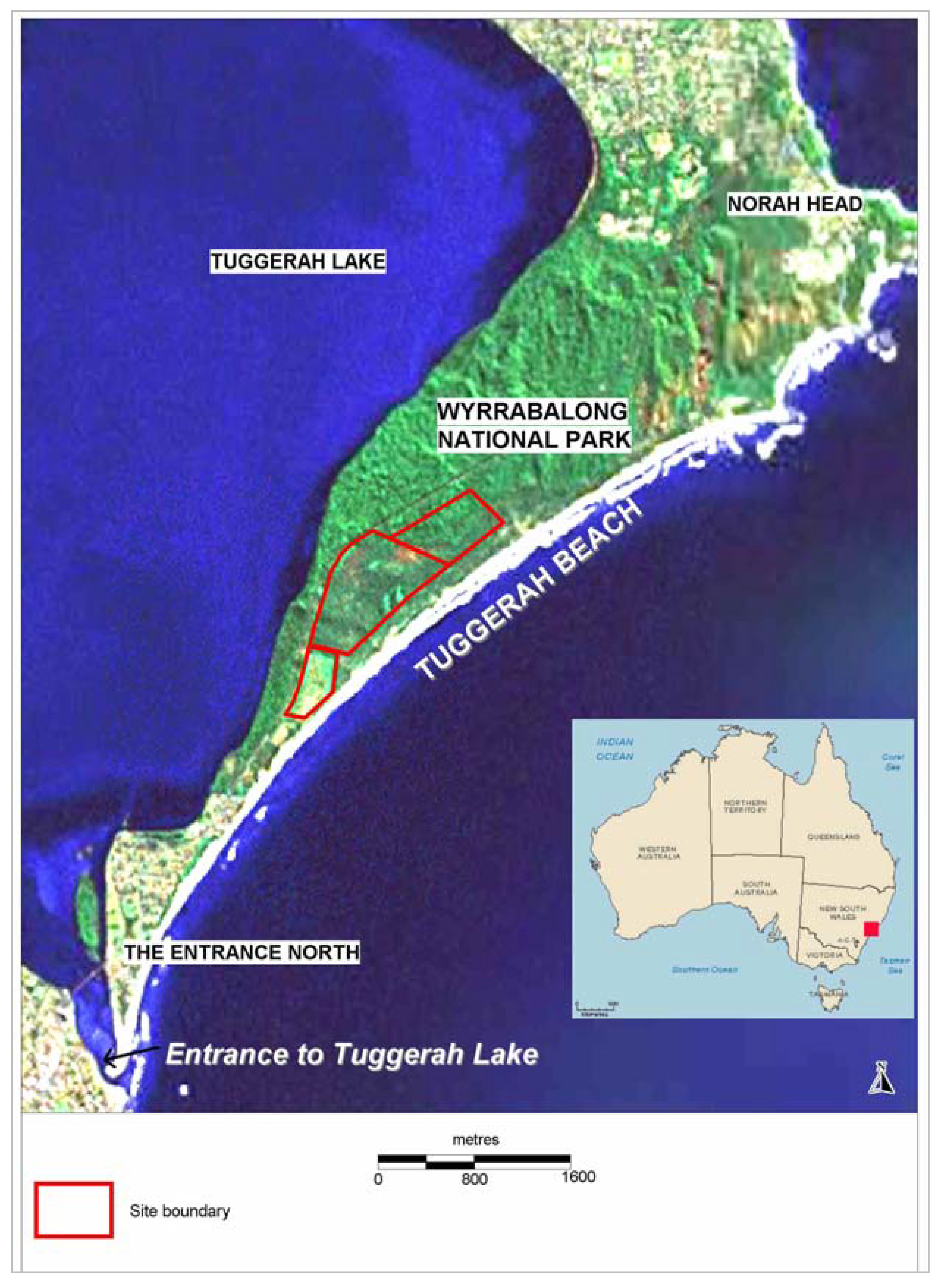
The 100 ha Magenta Shores development is situated east of Wyrrabalong National Park and the estuarine Tuggerah Lakes complex; north of the township of The Entrance and natural opening of Tuggerah Lakes; west of a 40 ha strip of Coastal Protection Zone adjoining Tuggerah Beach; and south of the National Park and Norah Head (
Figure 1). The site is on land purchased from Darkinjung Local Aboriginal Land Council.
Figure 1.
Site location overlaid on Google Earth image.
Figure 1.
Site location overlaid on Google Earth image.
In the National Park and on the site, there is remnant littoral rainforest supporting Syzygium paniculatum (magenta lilly pilly) and banksia woodland/eucalypt forest providing habitat for Squirrel Glider (Petaurus norfolcensis). Syzygium paniculatum is listed as a vulnerable flora species under Australian National and State legislation and the squirrel glider is listed as a vulnerable fauna species under State legislation.
1.2. Coastal Sand System
Australian coastal planning aims to avoid conflict with natural coastal evolution. Therefore it has to rely on a solid understanding of the mechanism of land-sea interactions [
2]. The approximately 7.5 km south-east facing Tuggerah Beach is exposed to strong winds and storm events. The northern part at Pelican Point is partly sheltered by an offshore reef. The southern part at the North Entrance receives some protection from reefs which extend off the entrance to Tuggerah Lake (
Figure 1). The entire beach is backed by a sand barrier system which is 300 m wide in the south, broadening northward to a 2 km width at Pelican Point [
3]. This sand barrier system protects Tuggerah Lake from ocean swells.
Tuggerah Beach is affected by surf swell, resulting in a wave height averaging 1.6 m. This maintains a double bar system running the length of the beach with the inner bar usually detached from the beach [
3].
Tuggerah Beach is a “zeta” beach, typical of New South Wales coastal embayments [
4,
5]. In embayments, sand is deposited as a series of stabilised foredunes from offshore sands [
6,
7]. Provided there is sufficient vegetation growth to limit wind blown sand movement of the foredune, a dune system consisting of a series of parallel beach ridges will be formed [
4]. During storm events, sand is returned to offshore sands from truncation of foredunes [
8]. Associated with the marine deposition process, there is sorting of the sands with bands of high concentration of heavy mineral sands laid down in the coastal dunes [
3].
One of the characteristics of open fronted beaches (microtidal environments) [
9], such as Tuggerah Beach, is erosion during storm events. At Tuggerah Beach, decades of mineral sand mining and removal of native vegetation has exacerbated erosion.
1.3. Environmental History and Its Consequences
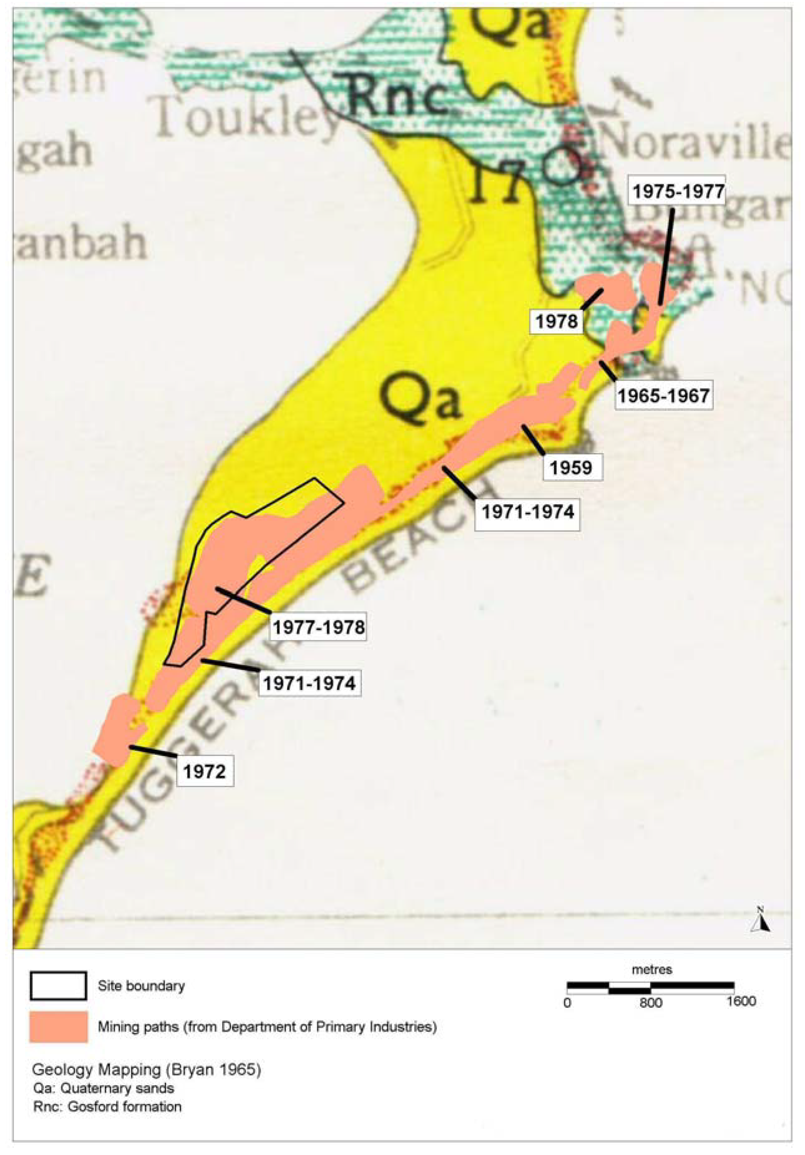
The entire length of the beach dunes of Tuggerah Beach were mined for mineral sands between 1959 and 1978, with the Magenta Shores site being extensively mined between 1971 and 1978 (
Figure 2). Under natural conditions, incipient dunes are eroded approximately every 5 years and foredunes every 10 years, but extraction of mineral sands is known to initiate erosion on previously stable or prograding beaches [
10].
Following the mining, the South African dune plant
Chrysanthemoides monilifera (bitou bush) was widely planted along the Australian east coast to stabilise and revegetate coastal sand dunes [
11]. The consequence was highly erodible steep faced sand slopes, covered largely by monostands of bitou bush. Bitou bush alters soil properties through increased litter, impairing establishment of native species [
12] and possibly lowering
Rhizobium soil-fungi levels [
13]. Fungi form hyphal matrices which bind sand particles [
14].
Figure 2.
Geology and sand mining paths.
Figure 2.
Geology and sand mining paths.
Tuggerah Beach is exposed to wave attack and storm bite erosion [
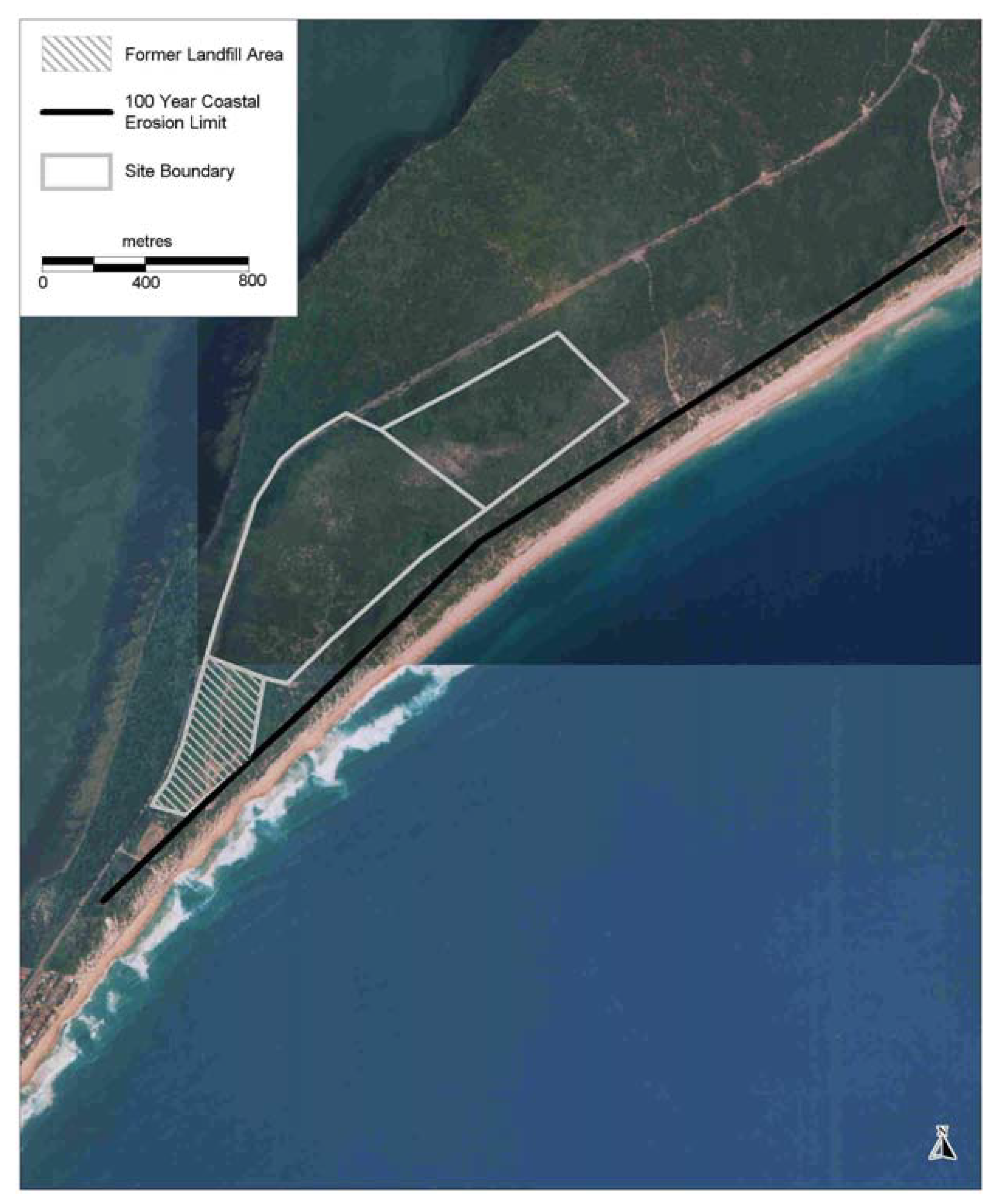
15] along the majority of its length. Heavy mineral sand mining with sand stripping, loss of native vegetation, establishment of exotic cover species and reduction of soil binding fungi increases soil mobility in storm events. Historical beach movements, knowledge of the sand transport behaviour of the area and the presence of offshore reefs indicated that any long term beach recession would be minor in comparison to any potential storm erosion impacts. Erosion from a 1 in 100 year storm event was estimated to be up to 300 cubic metres of sand loss per metre length of Tuggerah Beach. At the Magenta Shores development site, this level of sand loss would expose the content of a former landfill site in the south. The former 1980s and 1990s landfill operation is approximately 100 m from the beachfront (
Figure 3).
Figure 3.
Estimated 100 year coastal erosion limit and location of former landfill.
Figure 3.
Estimated 100 year coastal erosion limit and location of former landfill.
1.4. Vegetation Post Mining and Prior to Development
In 2004, thirty years post mining, the native vegetation was restricted to a narrow band of
Spinifex sericeus (Spinifex) on the incipient foredune. This is consistent with Spinifex seed being deposited by springtides [
16]. In the south, Bitou Bush dominated the foredunes (landward of the incipient foredune), resulting in a highly erodible steep landform. Towards the north, there was a greater native component, a more even gradient and a wider incipient foredune (
Figure 4).
Figure 4.
Difference in north and south related to vegetation composition in 2004.
Figure 4.
Difference in north and south related to vegetation composition in 2004.
In the development area, the mined sand had been colonised by the native
Leptospermum laevigatum (coastal tea-tree) and bitou bush. Dense swards of coastal tea-tree are characteristic following disturbance by sand mining [
17]. West of the previously mined area on the site, there was a narrow band of littoral rainforest and banksia woodland /eucalypt forest. This unmined vegetation was bounded by the main road to the west and flattened previously mined land to the east. The band of unmined vegetation was affected by edge disturbances and exposure to coastal salt spray.
2. Development of Effective Integrated Management Strategy and Ongoing Implementation
2.1. Planning
Following development approval in February 2004, all components of the development had to be synchronized. Senior staff, principal engineers, scientists, the golf course designer and architects met and communicated regularly for six months to plan the project and its operation.
As the development progressed to construction phase, integrated management meetings intensified to weekly and included contractors and supervisors. At the initial meeting, the colour magenta was assigned to all “no go” conservation areas. Before the next week’s meeting, an onsite Global Positioning System (GPS) base station was becoming operational. Ecologists and surveyors had clearly recorded “no go” areas on the centralized construction plan and identified the areas on ground with magenta coloured survey tape. All staff and contractors were fully aware of the meaning of magenta tape, which reduced the risk of accidental incursion into conservation areas. All persons onsite signed induction forms and were reminded in specific weekly toolbox talks of significance of the “no go” areas. Large machinery was also equipped with 3-D GPS systems programmed with boundary alarms.
During planning, waste streams and resource assets were carefully assessed to minimise new material used onsite and material leaving the development site. Throughout the planning and construction phase, recyclables and any waste were accurately calculated. Contractors submitted reports detailing type, quantity and destinations of materials. Dedicated plastic, paper, glass, metal and gyprock bins with colour coding and signage, approved by the handling company, were kept close to the specific construction task locations. There were incentives such as weekly barbecues if waste targets were achieved and penalties if subcontractors were found to be entering conservation areas or mixing waste.
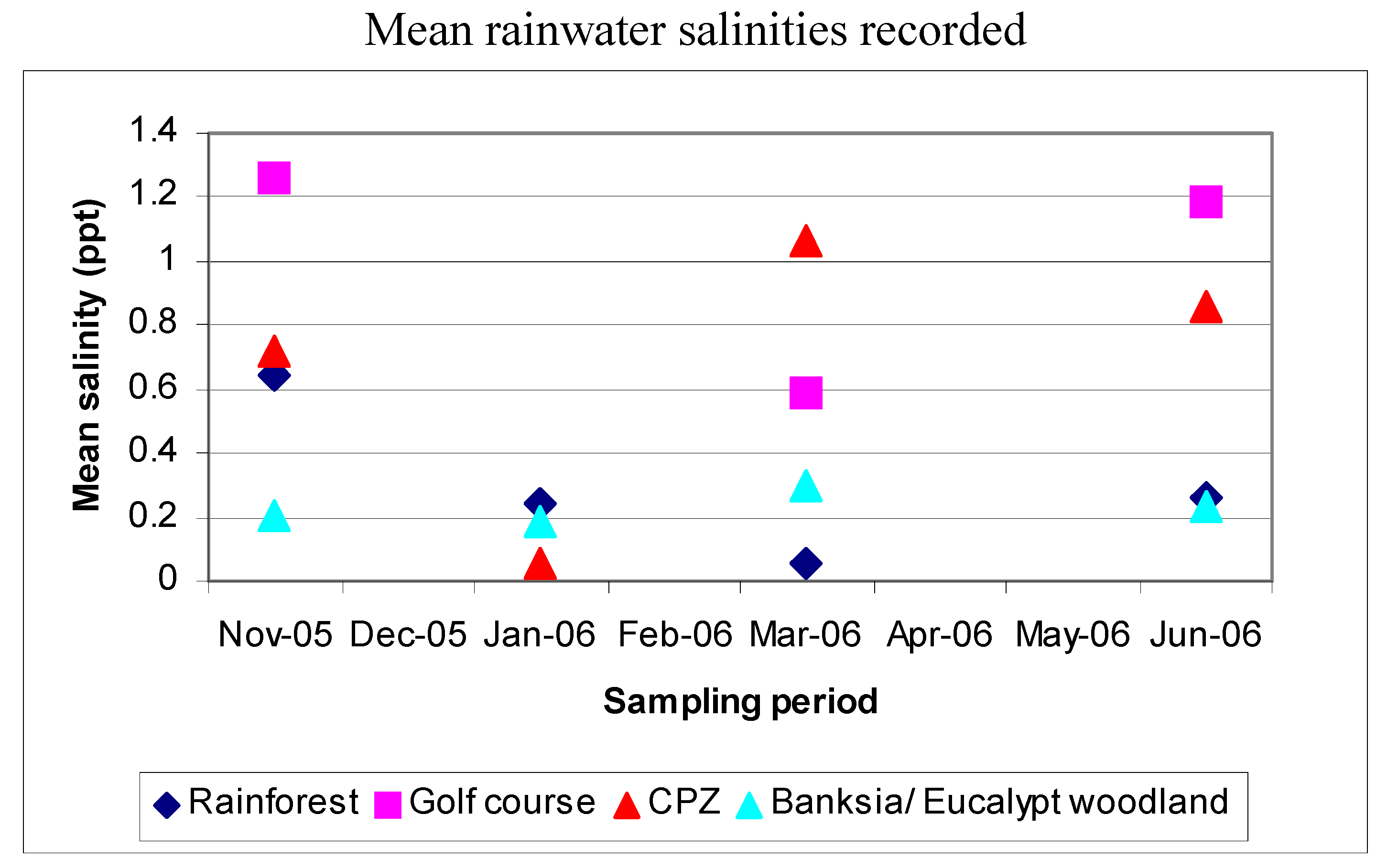
2.3. Monitoring Impact of Salt Spray
To test the extent of wind-borne sea spray, rainwater collectors were positioned along five long transects across the site. The rainwater salinity was monitored between November 2005 and June 2006. The site is subject to coastal winds [
18].
The extent of rainfall had little impact on the rainwater salinity recorded (
Figure 5). The highest salinity readings were recorded in the open areas of the CPZ and golf course, with rainwater salinity equivalent to about 3% of seawater salinity. Lower readings were recorded in the banksia woodland/ eucalypt forest and littoral rainforest which are protected by the re-constructed landform (
Figure 5).
Figure 5.
Rainfall during the sampling period and mean salinity of rainwater at monitoring locations.
Rainfall recorded
| | Nov 2005 | Dec 2005 | Jan 2006 | Feb 2006 | Mar 2006 | April 2006 | May 2006 | Jun 2006 |
|---|
| Rainfall (mm) | 77.2 | 49.4 | 72.4 | 35.0 | 69.6 | 45.8 | 109.8 | 224.6 |
Figure 5.
Rainfall during the sampling period and mean salinity of rainwater at monitoring locations.
Rainfall recorded
| | Nov 2005 | Dec 2005 | Jan 2006 | Feb 2006 | Mar 2006 | April 2006 | May 2006 | Jun 2006 |
|---|
| Rainfall (mm) | 77.2 | 49.4 | 72.4 | 35.0 | 69.6 | 45.8 | 109.8 | 224.6 |
2.4. Additional Sediment Fencing
As a consequence of the retention of the pre-development crest heights, a high mound, an artifact of the sand mining in the northern section of the reconstructed dune, was not reshaped. This high area was allowed to naturally wind erode. In February 2006, a minor blowout began to form as sand moved off this mound. To lessen the slope and aid in the regeneration process, it was necessary to create additional sand trapping. One kilometre of organic jute fabric, 600 mm high, fastened to wooden stakes, was placed in a series of rows approximately parallel to the beach (
Figure 6).
Figure 6.
Placement of jute fencing.
Figure 6.
Placement of jute fencing.
The 200 g/m2 jute fabric with 40 percent porosity was chosen to capture sand both in front and behind the fence. To minimise blow outs forming, the jute was overlapped in a triangular shape with no sharp defining edge at the ends of each fence. These fences assisted in retaining sand volume in the reconstructed dunes.
2.5. Reuse of Existing Natural and Introduced Waste-Stream Materials
Reuse of vegetation
More than 50,000 cubic metres of bitou bush, from approximately two thirds of the 2.3 km long by 30 m wide beach dune in the Coastal Protection Zone, were to be removed. An even greater volume of bitou bush and coastal tea-tree were to be cleared for the development. This volume of organic material exceeded the local landfill capacity. As golf courses are largely artificial environments requiring intensive resource input and maintenance [
19], including control of dicots, the re-use of bitou bush as an organic additive to golf course soils was investigated.
Fresh bitou bush was chopped up into fragments of less than 5 cm length and added to beach sand, on a percent by volume basis. Four bitou bush mulch volumes (0%, 5%, 10%, 20%) were tested using three grass types, each with 5 replicates. The grasses trialled were those being considered for the Magenta golf course. Two
Cynodon dactylon (Couch) turf varieties ‘Windsor green’ and ‘Conquest’ were planted as 5 cm length stolons in a grid pattern with 10 cm intervals.
Festuca spp. seed mixture of 1:1 Hard Fescue and Sheep Fescue was planted at a density of approximately 30 g/m
2. Fertilizer (2.5 g sulfate of ammonium) was added to each pot four times during the two month trial period. The planting medium was kept moist continuously for the first two weeks and then decreased to 2-3 short waterings per day. Final grass percent cover was estimated from photographs and analysed using a Two-way ANOVA. Although seed mix trial pots had a higher final percent cover, the trials demonstrated that the increased cover achieved was correlated with increasing Bitou Bush volume for all grass types (
Table 1).
Table 1.
Results of adding bitou mulch to three golf grass types.
Table 1.
Results of adding bitou mulch to three golf grass types.
| Mean grass percent cover by percent Bitou mulch added |
Individual 95% CIs For Mean Based on Pooled StDev
Percentbitou Mean -----+---------+---------+---------+----
0 60.3333 (----*----)
5 77.2000 (----*----)
10 83.6667 (----*----)
20 89.4667 (----*----)
---+---------+---------+---------+------
60 72 84 96 |
| Mean grass percent cover by grass type |
Individual 95% CIs For Mean Based on Pooled StDev
Grasstype Mean ---+---------+---------+---------+------
Windsor 62.0 (----*---)
Conquest 72.1 (---*---)
Fescue 98.9 (---*----)
---+---------+---------+---------+------
60 72 84 96 |
Bitou bush was readily incorporated as fine mulch into the golf course soil using a mechanical tritter. This enhanced the growth of the golf grasses by increasing organic soil content and soil moisture retention; hence reducing sand erosion risk and irrigation demands. Due to its low fibre content and potential to limit establishment of native flora [
12] and sand binding fungal hyphae [
13], bitou bush was not used on the reconstructed dune.
With its high fibre content and low break-down rate [
20], coastal tea-tree was used to trap wind blown sand and native seed on the dune reconstruction [
21]. This method departs from standard erosion control measures used in Australia, of woven synthetic cloth attached to wire strained between steel/treated pine supports at right angles to the prevailing wind [
22]. In New Zealand, tea tree branches are woven between stakes driven into the ground [
20]. Similarly, timber slat fencing with 50 percent porosity aligned parallel to the beach is used in the United States [
1].
Figure 7.
Coastal tea-tree being placed on the reconstructed dune crest.
Figure 7.
Coastal tea-tree being placed on the reconstructed dune crest.
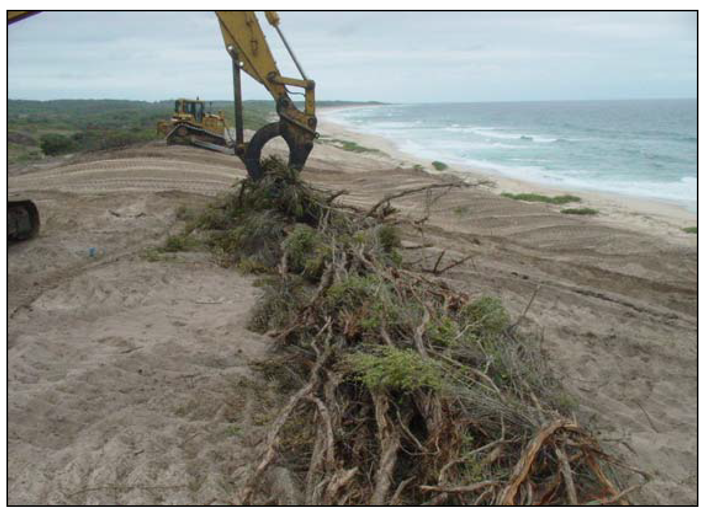
At Magenta, the coastal tea-tree cleared for the golf course was formed into two loosely packed porous windrows along approximately 1.2 km of the re-shaped outer dune. The windrows were placed about 10 m apart in similar locations to existing crests, 20-30 m upslope of existing Spinifex cover on the incipient dune (
Figure 7). This provided calmer microclimatic conditions on the wind exposed beach foredune, mimicking the natural vegetation cover for colonizing native dune species.
Groundwater
Investigation of groundwater in 2000 revealed that ammonia levels, exceeding ANZECC freshwater quality criteria, was probably migrating off-site from the former landfill area toward Tuggerah Lakes and the ocean. The nutrient rich water from the landfill leachate and from the local sewerage works are viewed as valuable assets for the development. The landfill leachate in the groundwater is intercepted and pumped to an aeration pond for golf course use, reducing the risk of nutrient movement to Tuggerah Lake and remnant unmined vegetation. Following the upgrade of the local sewerage works, recycled treated water supplies irrigation water for the course. A dual pipe system in the residences and the resort complex allows non-potable water to be used for gardens and flushing toilets. The water management system saves approximately 400 million litres of potable water a year on the Magenta Shores site alone [
23]. The extension of the dual pipe system provides non-potable water to nearby towns, lessening the local water demand for landscape use.
2.6. Ongoing Implementation
To prevent degradation of the dune system by beach users, a public carpark and a dedicated access way of timber slats, capable of supporting emergency vehicles, were constructed. Access ways reduce the risk of sand disturbance and compaction, allow for natural dune ecosystem development and provide community access to the beach.
With the completion of final phases, walking tracks with educational signs have been established in restored areas. Manuals promoting best practice ecological environmental and sustainable development are given to owners of the houses and villas.
3. Results
3.1. Sand Volume
In June 2007, there was an east coast low with wind speeds up to 135 km/hr [
24] and a monthly rainfall of 574.6 mm (more than four times the monthly average) [
24]. This major storm event resulted in beach erosion along the coast, including the formation of a 10 m deep sand cliff adjoining homes fronting Tuggerah Beach at North Entrance. At Magenta, the incipient dune was maintained and the re-constructed landward foredunes have increased in volume (
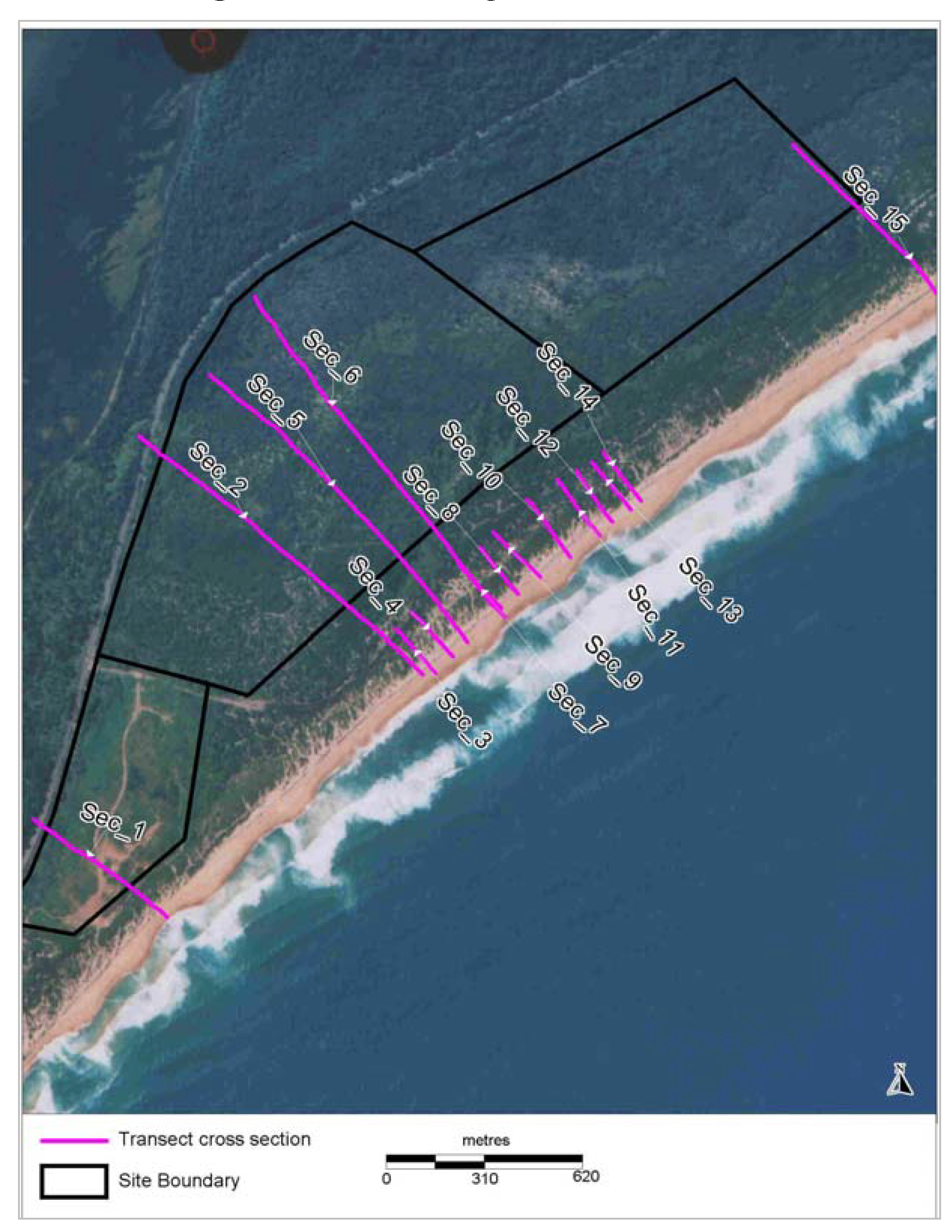
Figure 8). The volume of sand is being monitored annually using a series of long transects (
Figure 9). From the regular monitoring, there has been progressive stabilisation of the parallel beach ridge landform (
Figure 8).
Figure 8.
Changes in sand heights recorded from representative cross-sections at northern boundary, midway and southern end of site.
Figure 8.
Changes in sand heights recorded from representative cross-sections at northern boundary, midway and southern end of site.
Figure 9.
Monitoring transect locations.
Figure 9.
Monitoring transect locations.
3.2. Groundwater
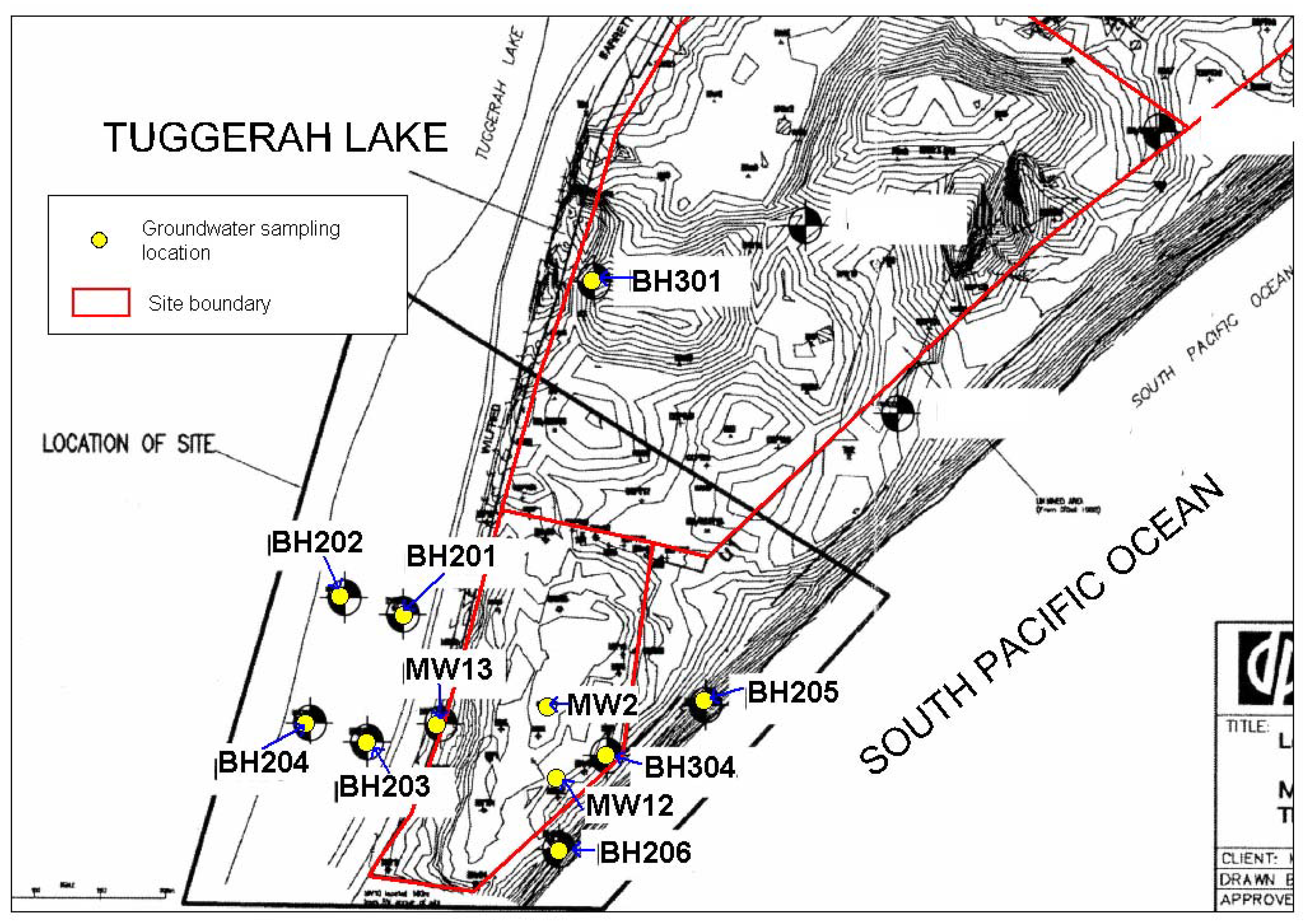
In 2000, the area of the former landfill had levels of ammonia between 2.6 and 14.33 mg/L above the ANZECC freshwater quality criteria of 1.49 mg/L (sampled in MW2, MW12, MW13 shown in
Figure 10). A leachate drain was installed in February 2005 to catch groundwater from the landfill. Water from the leachate drain is pumped to a holding pond to be mixed with irrigation water for the golf course.
Groundwater has been monitored since September 2004, from boreholes located in the former landfill area (BH304), the leachate drain (MW13 sampled as boundary of landfill prior to February 2005), near Tuggerah Lake (BH201, BH202, BH203, BH204), the littoral rainforest (BH301) and the ocean (BH205, BH206) (
Figure 10).
Figure 10.
Southern area of site boundary and groundwater sampling locations overlaid on borehole location map provided by Douglas Partners Pty Ltd.
Figure 10.
Southern area of site boundary and groundwater sampling locations overlaid on borehole location map provided by Douglas Partners Pty Ltd.
In the months immediately following installation of the leachate drain, ammonia levels recorded at MW13 rose rapidly (59 mg NH3/L in March 2005 and 120 mg NH3/L in July 2005). As this water was pumped out of the drain, ammonia levels in groundwater recorded near Tuggerah Lake fell to less than 1 mg/L. However, in August 2006 ammonia levels began to rise again (17 mg/L at BH203). Investigation found that the leachate pump was not being operated. When pumping resumed, levels recorded at MW13 fell back to 0.63 mg/L and have remained at less than 8 mg/L, with 3.5 mg/L recorded in August 2008. Ammonia recorded in groundwater near Tuggerah Lake had fallen to 1 mg/L in March 2008. As long as the water from the leachate drain continues to be diverted into irrigation water and the leachate drain is working as intended, the risk of nitrogen pollution moving towards Tuggerah Lake is reduced.
4. Conclusions
Magenta Shores, on the New South Wales central coast fronting 2.3 km of Tuggerah Beach, was environmentally degraded from former sand-mining and use as a landfill site. The sustainability challenges of the project were met through clear identification of existing environmental risks, application of scientific research, integrated team management and stakeholders’ cooperation.
From analysis of historical beach movements, the expected storm bite from a 1 in 100 year storm event on Tuggerah Beach was up to 300 cubic metres of sand per linear metre of beach. To increase the natural defence against storm waves, the incipient foredune was retained and a parallel beach ridge landform, typical of a coastal Quaternary sand system, was re-established by mimicking natural processes. Sand in the Coastal Protection Zone was wind deposited into the protected micro-environment of coastal tea-tree windrows placed on the re-constructed crests and slowed by colonising native dune species. In the development area on the previously mined landform, sand was reshaped to mimic a parallel dune ridge landform. The result is an increased stabilised sand volume enhancing storm and wind protection to built assets, remnant littoral rainforest and the banksia woodland/ eucalypt forest and Tuggerah Lake estuarine complex. Continued review of dune profiles and sand volumes from annual surveys of long transects allowed early detection of sand movements and implementation of additional erosion controls.
The coordinated large scale onsite recycling and waste management program during construction saved on landfill, transportation and natural resources. It also addressed the existing environmental risks of contamination to Tuggerah Lake. From the bitou bush and grass trial, bitou bush removed from the Coastal Protection Zone was successfully trittered into golf course soils to improve grass growth. Water and fertilizer demands were reduced by intercepting leachate from the landfill, upgrading the local sewer treatment plant and installing a dual pipe system for non-potable use of recycled water on site and in nearby towns. Continued groundwater monitoring is vital to ensure that the leachate drain continues to divert contaminated water away from Tuggerah Lake.
The benefits to the stakeholders from the Magenta Shores development included upgrading of the local sewer treatment plant; a reliable customer for non-potable recycled water; construction of a public pipeline servicing the adjoining township; development assets in the form of low energy and water demanding housing and resort accommodation, a world class golf course, and improved beach amenities and accessibility; as well as ongoing employment for locals.
Without the development and subsequent management requirements, contaminated groundwater leachate would continue to move to Tuggerah Lake and sand would continue to erode and threaten the integrity of littoral rainforest and banksia woodland on the site and in the adjoining National Park, as well as the Tuggerah Lake estuarine complex.
The challenges of the ecological sustainable development of Magenta Shores were met as a result of communication between all stakeholders and application of engineering and scientific research, which enabled implementation of environmentally aware practices and integrated management strategies.
Acknowledgements
We especially wish to thank the Mirvac development team for their commitment to the project, including the Development Director Gavin Tonnet, Senior Development Manager Graham Cooper, Construction Manager Gavin Rea, Services Coordinator Wayne Moenting, Development Manager Kathy Arici, Golf Course Superintendent Kenton Boyd and golf course designer Ross Watson; Dave Pross of Darkinjung Local Aboriginal Land Council, staff of Wyong Council including Garon Staines, Adam Mularczyk and Garry Mclachlan, Johnson Partners surveyors for sand height monitoring; Douglas Partners for groundwater monitoring; Webb, McKeown & Associates for detailed analysis of sand movement on Tuggerah Beach, Daracon especially Site Project Manager Gerard Morton, Foreman Rod Lang and dozer driver Carl Schubert, Environmental Officer Julia Olsen, Erica and Allan Platt of Tharwa Nursery for assistance with the grass and bitou bush trial; Margaret Donald for statistical advice, Ashleigh Keast for analysis of the grass cover photographs, Emma Laxton for collection and analysis of rainwater samples, Polly Simmonds, Jane Rodd and the reviewers for comments on the draft; and every person who has contributed to the success of the project.
References
- Mclachlan, A.; Brown, A.C. Ecology of sandy shores; Academic Press: Liverpool, Merseyside, UK, 2006. [Google Scholar]
- Dronkers, J. Dynamics of coastal systems. In Advanced Series on Ocean Engineering; World Scientific: Leidschendam, The Netherlands, 2005. [Google Scholar]
- Short, A. Beaches of the New South Wales Coast. A guide to their nature, character, surf and safety, 2nd ed.; Sydney University Press: Sydney, Australia, 2007. [Google Scholar]
- Thom, B.G. Late Quaternary coastal morphology of the Port Stephens-Myall Lakes area, New South Wales. J. Proc. R. Soc. N. S. W. 1965, 98, 23–36. [Google Scholar]
- Haslett, S.K. Coastal Systems; Routledge: New York, USA, 2000. [Google Scholar]
- Sale, M.; Sale, C. World, Water and the Environment; Shakespeare Press: Sydney, Australia, 1967. [Google Scholar]
- Short, A.D. Beach systems; definitions and global perspective. In Handbook of beach and shoreface morphodynamics; Short, A.D., Ed.; John Wiley & Sons Ltd: Chichester, UK, 1999. [Google Scholar]
- Bristow, C.S.; Pucillo, K. Quantifying rates of coastal progradation from sediment volume using GPR and OSL: the Holocene fill of Guichen Bay, south-east South Australia. Sedimentology 2006, 53, 769–787. [Google Scholar] [CrossRef]
- Van Rijn, L. Principles of coastal morphology; Aqua Publications: Amsterdam, The Netherlands, 1998. [Google Scholar]
- Bird, E.F.C. Bird. In Submerging Coasts; John Wiley & Sons: Brisbane, Australia, 1993. [Google Scholar]
- Barr, D.A. Restoration of coastal dunes after beach mining. J. Soil Conserv. Serv. N. S. W. 1965, 21, 199–209, cited in Department of Environment and Conservation. Approved Threat Abatement Plan for Invasion of Native Plant Communities by Bitou bush/Boneseed (Chrysanthemoides monilifera). Department of Environment and Conservation, Hurstville, 2006. [Google Scholar]
- Lindsay, E.A.; French, K. Litterfall and nitrogen cycling following invasion by Chrysanthemoides monilifera ssp. rotundata in coastal Australia. J. Appl. Ecol. 2005, 42, 556–566. [Google Scholar] [CrossRef]
- Vranjic, J.A.; Woods, M.J.; Barnard, J. Soil-mediated effects on germination and seedling growth of coastal wattle (Acacia sophorae) by the environmental weed, bitou bush (Chrysanthemoides monilifera ssp. rotundata). Austral Ecol. 2000, 25, 445–453. [Google Scholar] [CrossRef]
- Jehne, W.; Thompson, C.H. Endomycorrhizae in plant colonisation on coastal sand dunes at Cooloola, Queensland. Aust. J. Ecol. 1981, 6, 221–230. [Google Scholar] [CrossRef]
- Nielsen, A.F.; Adamantidis, C.A. Defining the storm erosion hazard for beaches. Aust. J. Civ. Eng. 2007, 3, 1. [Google Scholar]
- Hesp, P. The formation of sand “beach ridges” and foredunes. Search 1984, 15, 289–291. [Google Scholar]
- Burrell, J.P. Invasion of Coastal Heaths of Victoria by Leptospermum leavigatum (J. Gaertn.) F. Muell. Aust. J. Bot. 1981, 29, 747–764. [Google Scholar] [CrossRef]
- Bureau of Meteorology. In Climate statistics for Australian locations NORAH HEAD AWS, Site number 61366, Commonwealth of Australia. Available online: http://www.bom.gov.au/climate/averages (accessed 1 June 2009).
- Geary, J. Maintaining a golf course in an environmentally sustainable manner. In Proceedings of Environmental Issues for Turf, National Conference, March 1997; Australian Turf Research Institute: Concord West, Australia, 1997. [Google Scholar]
- Ramsay, D. Managing and adapting to coastal erosion on the west coast: Granity; Prepared for West Coast Regional Council; National Institute of Water and Atmospheric Research Ltd: Hamilton, New Zealand, October 2006. [Google Scholar]
- Hazelton, P.A.; Clements, A. Soil and landform reconstruction and re-establishment of coastal sand dune vegetation using natural resources. In Extended abstracts Soils 2008 Soil –The Living Skin of Planet Earth; Massey University: Palmerston North, New Zealand, Dec 1-5 2008. [Google Scholar]
- New South Wales Department of Land and Water Conservation. Coastal dune management, A manual of coastal dune management and rehabilitation technique, Coastal Unit: DLWC, Newcastle, 2001.
- Mirvac. Leadership in Urban Water Management: Magenta Shores. Available online: http://www.mirvac.com.au (accessed 3 August 2008).
- Bureau of Meteorology. In June 2007 East Coast Lows, Commonwealth of Australia; 2009. Available online: http://www.bom.gov.au/weather/nsw/sevwx/facts/events/june-07-ecl/index.shtml (accessed 1 June 2009).
© 2009 by the authors; licensee Molecular Diversity Preservation International, Basel, Switzerland. This article is an open-access article distributed under the terms and conditions of the Creative Commons Attribution license (http://creativecommons.org/licenses/by/3.0/).


