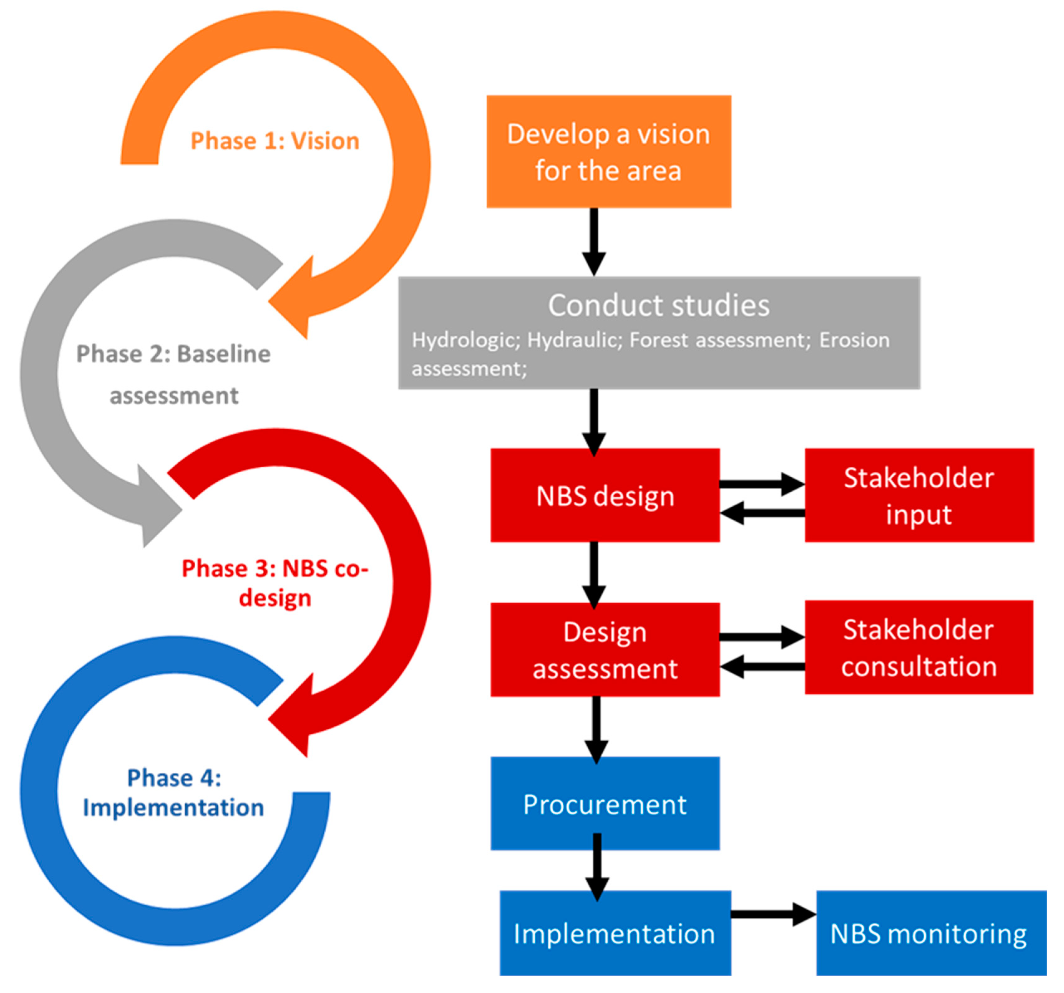
3.1. Vision Phase
Koiliaris CZO (a member of the LTER Europe Network) was established as an observatory by the Technical University of Crete in 2004. Since then, many graduate students and post docs from the Technical University of Crete and other institutions from Europe, the USA, and China have been conducting research on water and soil management. Results have been published in over 40 peer-reviewed journal publications [
21]. Funding from several European and Greek funding agencies (EU Projects: SoilTrec, SoilCritZone, eLTER, adv_eLTER, eLTER-PLUS, eLTER-PPP; Greek Projects: CyberManagement, Thallis-Cybersensors, EEA Aquaman and the present project funded by the Region of Crete) have provided the resources to a) establish the necessary monitoring stations and equipment to collect long-term data, b) develop a comprehensive understanding of the hydrologic and geochemical functioning of the watershed, and c) develop tools and methodologies for the sustainable management of water and soil resources that would lead to sustainable agricultural development for the area.
For 15 years the presence of the Technical University of Crete in the area has been continuous. We have been in constant contact with the local stakeholders, from the Mayor of the Municipality of Apokoronas to the local farmers and to Regional Officials. In addition, the economic crisis in Greece of the past 10 years and the three austerity programs created the underlying conditions to initiate a grassroots discussion for agricultural development. We have made many presentations in gathering with farmers discussing issues of agricultural development, soil sustainability and water management. The Technical University of Crete has become a well-accepted local “Institution” that guides public opinion on the issues of water resources and climate change adaptation and mitigation.
With this as a background, these local town hall meetings have shaped the vision for sustainable agricultural development that is closely linked with the karstic springs of White Mountains and Koiliaris River. The ecological quality of Koiliaris River based on the aquatic monitoring by the Ministry of the Environment is high. In addition, the riparian forest and the river is tightly connected with the agricultural, touristic and recreational activities of the area.
However, agricultural expansion to the river has resulted in cutting down the trees of the riparian forest and cultivating the area with olive trees, citrus and avocado plantations, minimizing the extent of the riparian forest and its benefits. For this reason, during the past 20 years, significant bank erosion is taking place of the lower tributaries and the main course of Koiliaris River and the riparian forest has been reduced to a single line of trees by the river bank.
The significance of the problem in the Koiliaris River was identified after the spring of 2004 flood that caused major bank erosion, resulting in the over-topping of the riparian trees and the overall degradation of the river ecosystem in the area. The Municipality at that time partially restored the areas eroded in order to protect the remaining trees, but since then, no erosion protection works occurred.
We have raised the issue of the degradation of the riparian forest and the urgent need for restoration since the early years of the establishment of the observatory. Restoration of the riparian forest entailed, in this case, converting agricultural land (private property) to forest, and the socio-economic situation was not favorable toward initiating such a project.
There are multiple drivers that affect governmental decisions to tackle the issue of flood protection in Greece at various levels, the most important of which is public pressure and intense media scrutiny after an extreme event. It is well accepted in Greece that climate change and extreme events increase the number and magnitude of natural disasters. Such extreme events, in addition to property loss, often have human fatalities and become the primary cause for grass root movements that accelerate decision making and bypass bureaucratic procedures and governmental inactivity. Recent examples in Greece are the extreme floods in 2017 and the fires in 2018 in Attica, where many people died and property was destroyed. These events reinforce the need for protection from natural disasters. Greece, until recently, delayed the implementation of the flood management plans that are designed to develop the overall strategy for mitigating the impacts of extreme events as well as identifying the areas vulnerable to flooding; therefore, major, much-needed flood protection projects were not under consideration.
The unfortunate cases of 2017 and 2018 mobilized the regional government and the municipalities in seeking funding for flood protection projects and initiating appropriate studies. Finally, an extreme flood occurring in October 2017 in the KRB, with more than 2.2 million cubic meters of water being transported in 12 h, caused additional damage in the area and deteriorated the riparian forest, necessitating the study of its restoration. The conditions matured for the funding of the project. Locals and regional decision-makers were persuaded and agreed with the importance of the problem and, since then, they have had to identify the funding mechanism, write the specifications of the study, and follow the procurement mechanism.
The vision of the project was to develop bank erosion protection and flood protection using NBS and restore the extent of the riparian forest to 20 m on both sides of the river, creating a 5-km riparian forest corridor that will become the trade mark for the agricultural development of the area. The farmers giving up prime agricultural land to re-establish the extent of the riparian forest will send a message that “we care for sustainable land management” and that “we care to produce quality agricultural products”. This vision has kept the idea of the riparian forest restoration alive for the past 15 years until the right conditions materialized for its implementation.
3.2. Baseline Assessment Phase
3.2.1. Hydrologic Study
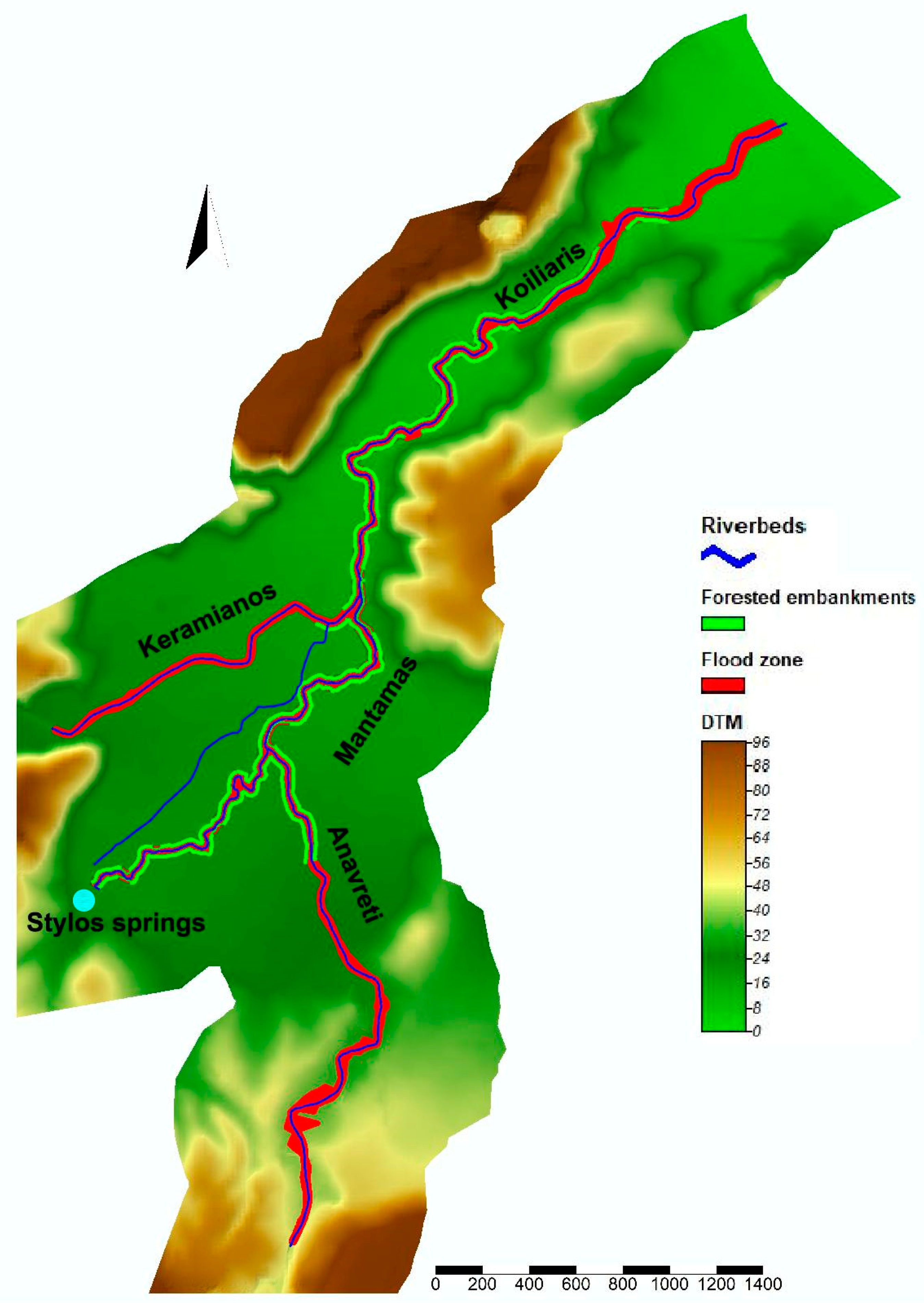
The KRB is a watershed with karstic formations. Like many Mediterranean watersheds, the hydrologic pathways of KRB is complex, consisting of a combination of surface runoff and karstic flow, originating from a system of karstic springs. The modelling of such watersheds demands the use of developed, operational models which can capture the variability of the complex flow. A variety of models have been introduced during the past 10 years to accomplish this task [
19,
22,
23]. In the context of this study, the Karst-SWAT model [
23] is used to model the flow of the surface and karstic springs of KRB, using observed flow data from hydrological stations.
More specifically, surface runoff in the watershed is formed by two main intermittent streams: Keramianos and Anavreti. Data for the simulation of surface flow are provided by a hydrometric station, situated along the Keramianos tributary. The classic SWAT approach is used for the determination of the surface runoff using the station located at Keramianos. Another hydrometric station, situated at the basin exit, supplies high frequency flow data which constitute a combination of surface and karstic flow. This station is used for the calibration of total flow at the basin exit, simulated using the Karst-SWAT model. All springs are modeled as one, based on the karstic two-reservoir model, developed by Nikolaidis et al. [
23], which is incorporated in the Karst-SWAT model.
However, two types of karstic springs can be identified in the KRB: the Stylos springs and the Anavreti spring. The Anavreti spring has 8 m higher elevation than the Stylos springs. Therefore, although defined by the same karstic system, they present different responses. The Stylos springs have permanent flow during the year, whereas the spring of Anavreti runs only when the springs flow exceeds 4 m3/s; this occurs during specific months, usually between December and March. We used historical data of the Stylos and Avavreti flows to develop the relationship that would apportion the total flow of the karst simulated by the model to the individual flows of the two springs.
The hydrologic study has the advantage of providing flow simulations for every point in the watershed as well as for both Stylos and Anavreti springs. These values can further be used for the determination of the design flow and the subsequent flood frequency and hydraulic analysis for each point of interest.
3.2.2. Hydraulic Study
The objective of the hydraulic study was to identify the 50-year return flood (Q50) for every stream segment and for each of the springs. A detailed assessment of flood frequency was conducted, separating the surface from the groundwater flow, as well as the individual surface flows of each stream and karstic flows of each spring. An analysis of extreme hydrological events was performed based on the annual maximum flow values of the 58-year simulated time series (1961–2018). The daily flows from 1961 to 2018 were processed using the statistical techniques of Gumbel and Log Pearson Type 3. The maximum annual flow for each cross section of the river was selected, based on the statistical analysis of the two methods.
The results showed that the Gumbel method presented smaller correlation errors and a greater regression coefficient, ranging from 0.85 to 0.98. The design flow was calculated 10.5 m3/s, 32.4 m3/s, 43.7 m3/s, 16.1 m3/s, and 55.5 m3/s for the Stylos spring, Anavreti tributary, Mantamas, Keramianos and Agios Georgios station, respectively.
For the hydraulic simulation of the system, it is important to convert the daily design flows with a 50-year return period determined from the statistical evaluation of the simulated data to hourly design flow. To do that, observed flood flow data from the hydrometric station at the basin exit (Agios Georgios) were used, in conjunction with the daily design flow estimated by the SWAT model. The 12 most significant flood episodes observed during the period 2007–2019 were examined and normalized flood frequency distribution curves were developed for each flood. Two of the floods had a duration of 24 h and the remaining ten a duration of 12 h. The most adverse flood, i.e., the flood which has the largest ratio of maximum hourly to total flow, was the one that took place on October 27th, 2017 and its frequency distribution was selected to convert the daily design flow to hourly. The daily estimated design flow (Q50) derived from the SWAT model for the main stream of Koiliaris (55.5 m3/s at the basin exit) was converted to hourly flow, using the hourly normalized distribution of the latter flood event. The maximum hourly flow was 19.0% of the total daily volume of water of the flood and this corresponds to an hourly design flow of 127.5 m3/s. Therefore, a safety factor of 2.3 was included in the design. Using the same safety factor, the design hourly flows for the Anavreti, Keramianos, Stylos, and Madamas were estimated to be 74.5 m3/s, 37.0 m3/s, 24.2 m3/s, and 100.5 m3/s, respectively.
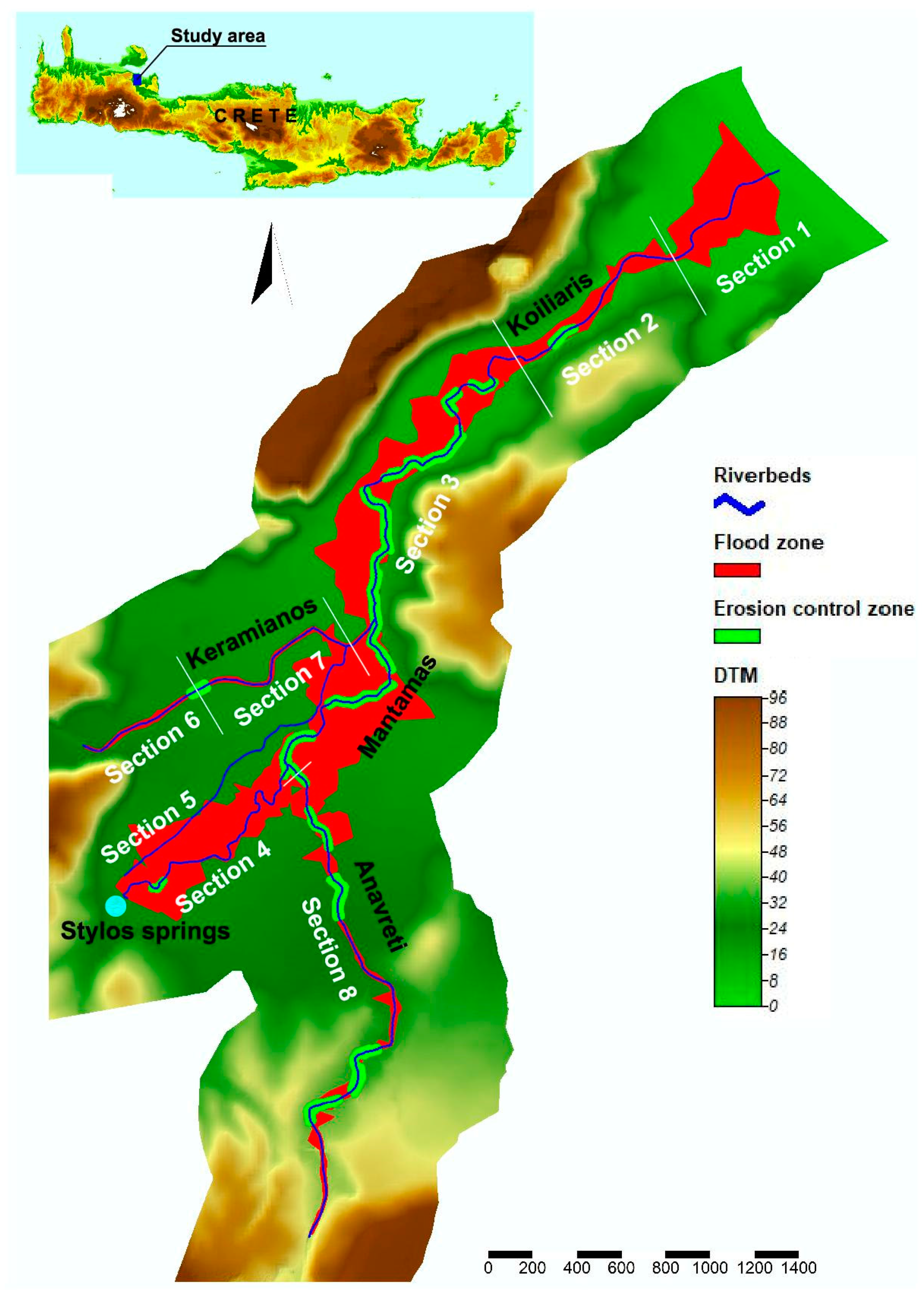
Having the design flows, the HEC-RAS model [
24] was used to determine the floodplain of Koiliaris River for the 50-year return flood. The model is one-dimensional and covers all types of flow for open streams. The data of the detailed surveying of the river and the surrounding area, were used for the determination of the critical water surface elevation. The flood routing was determined for all tributaries of Koiliaris. The floodplain was defined as the dashed lines connecting the intersection points of the water surface in a series of cross sections with the natural or landscaped terrain in the same cross sections (
Figure 2).
The flow in the beds is assumed to be non-uniform, due to the constant change in the shape of the cross-section and the bottom slope. Hydraulic calculation of permanent non-uniform flow is achieved by using the Energy Equation and a Manning value equal to 0.05 (natural stream). The input data include the geometrical data of each bed and the peak flood flow, as calculated above for each stream branch. A uniform flow depth upstream and downstream of each bed section was obtained as a boundary condition. Floodplains with flood lines were constructed for all streams. As it is obvious from
Figure 2, the width of the flood is higher downstream of the Stylos (average width of 65.0 m) and Anavreti (30.6 m) springs, and continues to be significant throughout the Koiliaris main stream (75.2 m with a maximum of 127 m). The Keramianos tributary and the Anavreti stream, on the other hand, present lower flood widths (25.5 and 30.6 m, respectively). Anavreti has a higher contribution to the flood of the main stream of Koiliaris compared to Keramianos.
3.2.3. Erosion Assessment Study
The objective of the erosion study was to conduct an analysis of bank erosion and bank failure assessment. It was conducted after the floods of February 2019. The assessment consisted of a three-prong approach: 1) Field surveys for the identification of the cross sections of the bank and riverbed that have been eroded or are prone to erosion. 2) Soil samples collection for the characterization of the soil composition of the banks. 3) Bank erosion and failure risk estimation using the Bank Stability and Toe Erosion Model (BSTEM). BSTEM is integrated in version 5.0.6 of the HEC-RAS model.
Figure 1 presents the cross sections that have been identified from the field survey that have been eroded or that are prone to erosion. Out of a total 268 sections of the river, 80 were determined as those needing restoration and protection measures in one or both banks. These are cross sections located mostly in river bends and have degraded vegetation. By degraded vegetation we mean that the existing vegetation does not have the rooting system to keep the soil from erosion. An example is a field where the orange trees had replaced the indigenous vegetation of plane and willows trees.
The characterization of soil samples was conducted based on particle size distribution and the limits of A.S.T.M. The soil samples analyzed by means of sieves had a mass-median-diameter (D50) ranging between 0.07mm and 0.75mm and were characterized as “very fine sand” to “coarse sand”. The diameters D10, D30 and D60 for these samples were calculated 0.052 ± 0.022, 0.136 ± 0.097, and 0.396 ± 0.279 mm, respectively. The uniformity coefficient (Cu) ranged between 1.83 and 18.41, indicating that the majority of the samples were well graded. The coefficient of curvature (Cc) was calculated between 0.03 and 1.86. Analyses of the samples collected from the Koiliaris River showed that the composition of the riverbanks was sandy soils. The characterization of soil texture was a necessary input for the BSTEM model.
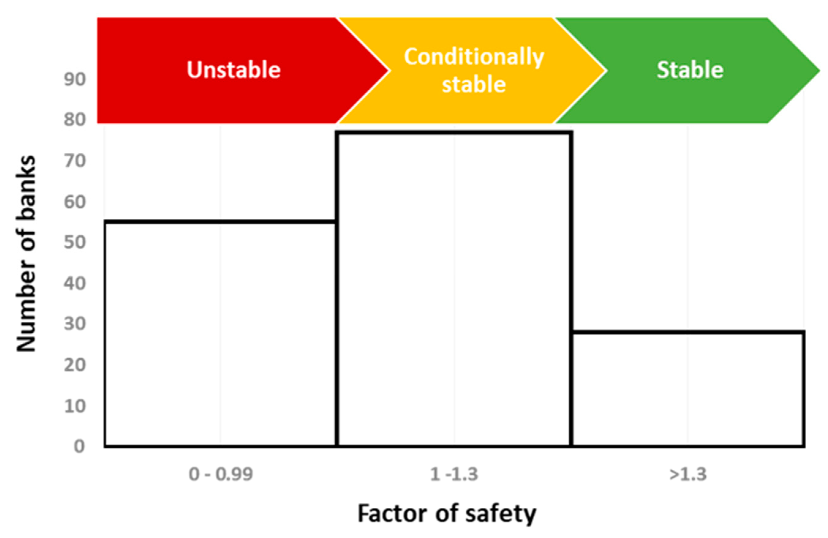
The simulation of bank erosion and the determination of the factor of safety (Fs) was conducted for the 80 cross sections (both for the right and left banks or 160 banks) that were prone to erosion (identified from the field survey).
The results showed that the Fs for 55 of the total 160 river sections studied, was between 0–0.99, suggesting unstable banks. The Fs for 77 banks calculated between 1–1.3, suggesting conditionally stable banks, i.e., stable but with little safety margin. The Fs for 28 banks was greater than 1.3 suggesting stable banks (
Figure 3). For each of the 132 banks found to be unstable or conditionally stable, measures for flood protection and for the restoration of riparian forest were proposed, as will be discussed later in this manuscript. These measures were vegetated stone walls and vegetated rip-raps. The proposed restored cross sections were simulated with the model to ensure that the measures will be effective and the banks stable.
3.2.4. Forest Assessment
For the forest assessment, field surveys were carried out to identify the existing woody vegetation (both upper and lower levels in terms of the presence of native, indigenous and alien species. The whole length of riparian vegetation was divided into eight sections (
Figure 2), and the main vegetation types recorded in each section are presented in
Table 1. Section 1 refers to the estuary section of the river, Sections 2, 3 and 4 to the main river, Section 5 is an artificial irrigation channel, Sections 6 and 7 refer to the Keramianos tributary, and Section 8 to the Anavreti tributary. The vegetation types were matched with the habitat types, which were classified according to the European Nature Information System (EUNIS).
The riparian natural vegetation of the Koiliaris River is basically composed of a few species with a dominant presence of
Arundo donax and Platanus orientalis, or many point sites such as
Tamarix spp., Vitex agnuscactus, Salix alba, Ricinus communis, Hedera helix (
Table 1), which gradually alternate as we move from the estuary to the main river segment. At the lower part of the river (Section 1) the vegetation consists of beds of
Phragmites australis and
Arundo donax. At Section 2, White Willows (
Salix alba) and Oriental Plane trees (
Platanus orientalis) appear, at the beginning sporadically, until they gradually dominate, eventually forming a riparian forest. Τhe forest assumes its typical form in Section 3. In this section, the presence of numerous climbing plants (mainly
Hedera helix and
Vitis vinifera) is characteristic. However, the forest is restricted near the banks of the river. Section 4 is characterized by the presence of Oriental Planes and White Willows which occur either solitary or in lines along the river. Very often the cultivated fields reach the banks, but in other parts of this section there is some space for natural vegetation. Section 5 is of no interest in terms of natural vegetation as it is an artificial irrigation channel. In Section 6, the absence of constant flow inhibits the development of a riparian forest. The upper part of Keramianos tributary comes into contact with zonal vegetation, so many species that are not typical elements of riparian vegetation occur there (e.g.,
Quercus coccifera and
Phillyrea latifolia). At the central part of this section, the vegetation is a riparian scrub of
Vitex agnus-castus,
Nerium oleander, Tamarix parviflora, Arundo donax and
Platanus orientalis which gives place to Provence cane (
Arundo donax) beds at its lowest part. In Section 7, the vegetation is transitional between Provence cane beds and riparian forest of White Willows and Oriental Plane trees. In Section 8, which corresponds to the tributary of Anavreti, a riparian vegetation of Oriental Plane is developed (the White Willow is absent in this section). The riparian natural vegetation is not continuous, but it is often interrupted by adjacent cultivated fields. Although the vegetation is not as developed as in the central part of Koiliaris River, at least at some parts could be characterized as a riparian forest.
The main pressure to the forest is the cultivation of fields that are very close to the banks. Taking into consideration that the floodplain is quite large, we can conclude that the natural boundaries of the riparian forest could extend several meters to each side of the river. The partial recovery of fluvial free space could be the solution for both sustainable existence of the forest and reducing to the minimum the effects of bank erosion. What we proposed is a three-zone model similar to that mentioned by Welsch [
25] for Sections 2, 3 and 4 of the river, and a two-zone model for the all other sections except Section 5. The three-zone model consists of a zone of undisturbed forest (10 m in width), a 15 m width zone of managed forest (where disturbance is allowed) and a 6 m width zone of cultivated fields that are under special management (e.g., agrochemicals and plowing are not allowed). The two-zone model, is similar but lacks the second zone of the three-zone model as described above. In that case undisturbed vegetation is not always a forest (depending on the site).
3.3. NBS Design Phase
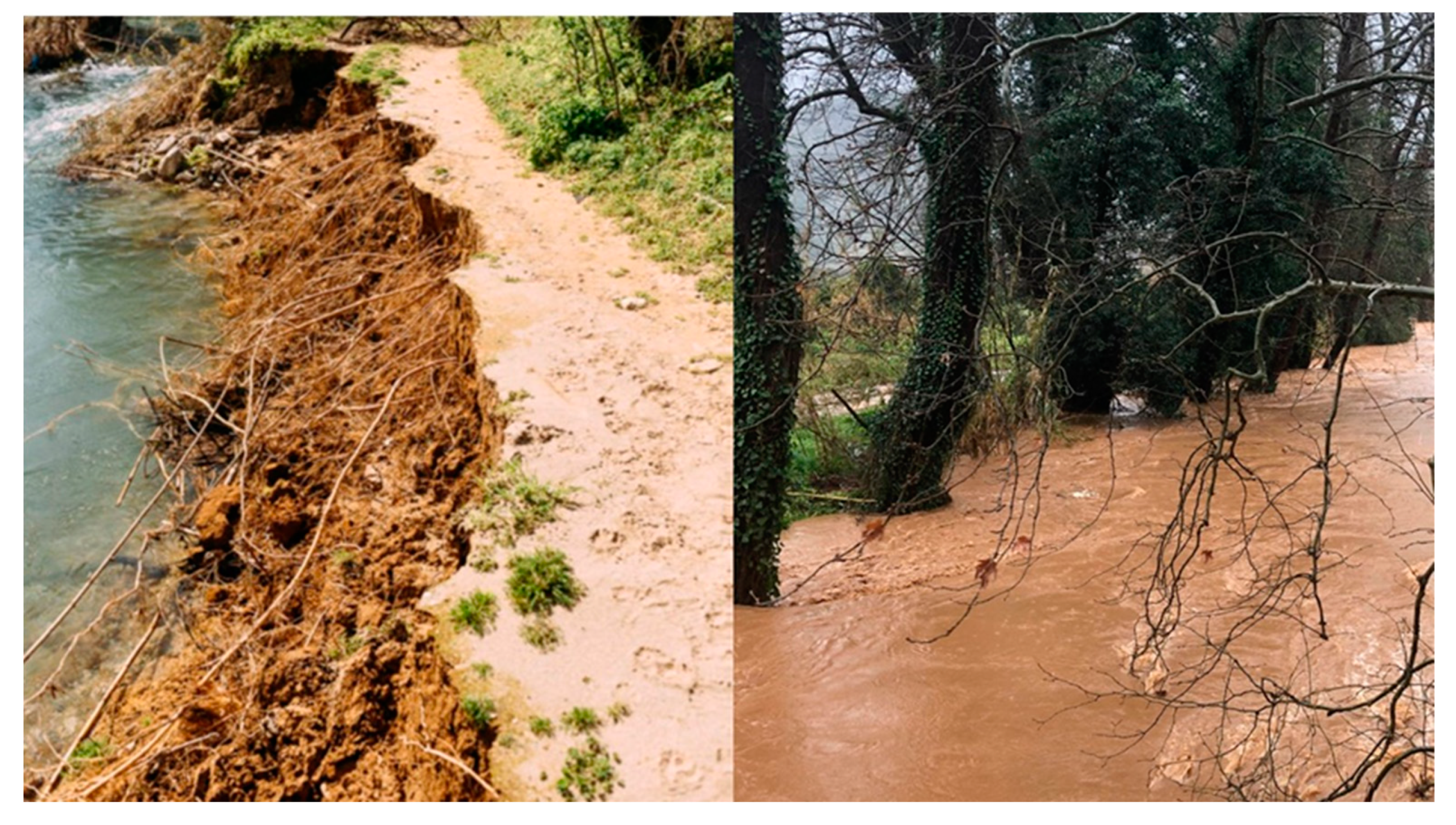
Our working hypothesis was that the ultimate, most effective solution to river bank erosion is the restoration of the riparian forest.
Figure 4 illustrates the effectiveness of native, riparian vegetation in protecting from river bank erosion. The left photo is from an eroded area where the orange grove was planted next to the river and the native vegetation was removed. The right photo is a non-eroded area with dense (single line) Oriental planes and other native species. The root density of the orange trees (an alien species that normally does not occur in riparian vegetation) does not create the conditions to consolidate the soil and protect it from erosion.
Recreating the riparian forest with native and indigenous species is the NBS answer to solving the river bank erosion of the Koiliaris River. However, the initial stages of reforestation are not very effective for erosion control. Therefore, additional action needs to be taken for the immediate protection of the eroded and prone to erosion river banks. This immediate action is the protection of the river bank with vegetated stone walls and vegetated rip-rap, as well as revegetated banks depending on the bank slope, erosion potential and existing vegetation.
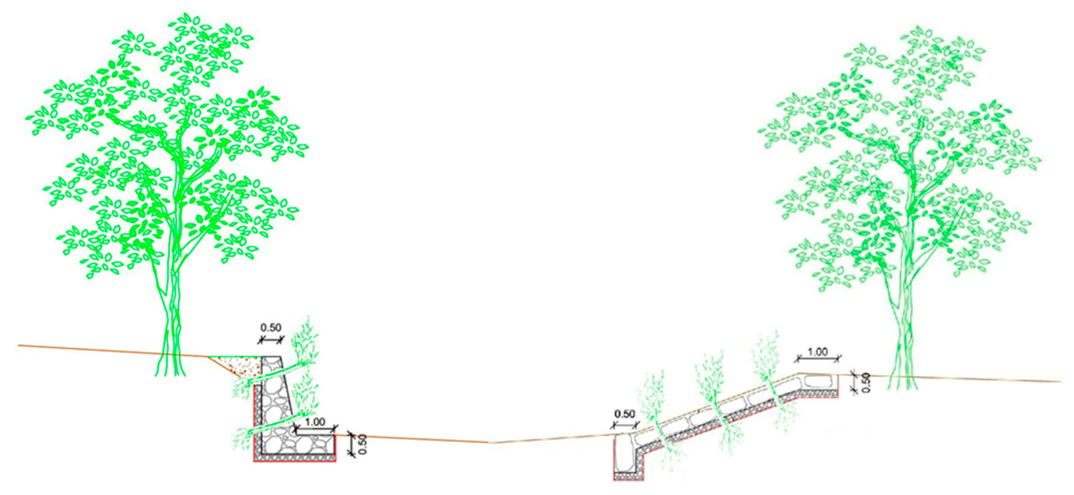
The proposed NBS was the restoration of the eroded banks with vegetated walls and rip-raps (
Figure 5) together with the restoration of the riparian forest. The latter means that we proposed to restore not only the last tree-row next to the river, but also to reclaim the riparian forest area from agriculture. This is a traditional NBS with multiple benefits for the stability of the banks from erosion as well as for the ecosystem of the river.
The proposal for the restoration of the forest can be divided into two parts. One part for the banks of the river and the other for the rest of the adjacent fields. In the first case, the restoration would take place by implementing soil bioengineering methods. The proposed bioengineering methods were live staking, vegetated riprap stone paving and vegetated stone walls (
Figure 5). These could provide both streambank protection and riparian forest restoration. For the rest of the restored riparian areas, the proposed restoration method was by creating a forest in a zone of 25 m in conjunction with the cultivated fields, by ball-planting Oriental Planes, White Willows and other native trees of the area.
Once the basic concept of the design was developed, we moved into the next phase of fine tuning it with the input of the local and regional stakeholders. These participatory activities allowed effective stakeholder involvement for NBS co-design. Stakeholder involvement in the co-design of the final solutions helped overcome the barriers and the conflicting objectives that usually arise in the implementation phase. The stakeholders involved in the processes were representatives in different roles who are related to local and regional governments as well as the local farmers and land owners. The local government was represented from the Mayor of Apokoronas and the Municipality Council that includes all parties and representatives from all villages. The Regional government was represented in the Monitoring Committee of the project, consisting of representatives of the Directorate of the Water Management of the Region, the Regional Unit of Chania, The Municipality of Apokoronas, the Directorate for Technical Services and the Technical University of Crete. The Forestry Directorate of the Region was also invited to the Committee meeting because they are essential players regarding the ultimate approval process in the implementation phase. The Monitoring Committee of the project had regular meetings in order to discuss the NBS design and approve the deliverables of the studies conducted in the Baseline assessment phase. The Directorate for Technical Services had an important role in the process as it was responsible for the prior approval of the design. Finally, the local farmers and land owners, and in general, the general public were the third type of stakeholders that their input was obtained through town hall meetings.
The proposed initial design raised multi-dimensional legislative, socio-economic, technical and personal conflicts that appeared during the consultation process. The most significant socio-economic conflict was the area extent of the flood. A land owner near the river, in order to transfer or sell the property, has to perform a flood delineation and show that the property is outside the flood plain. According the current legislation, flood-susceptible areas cannot be legally transferred, even within the family. The proposed flood plain has a maximum width of 127 m on both side of the river and many land-owners will be affected.
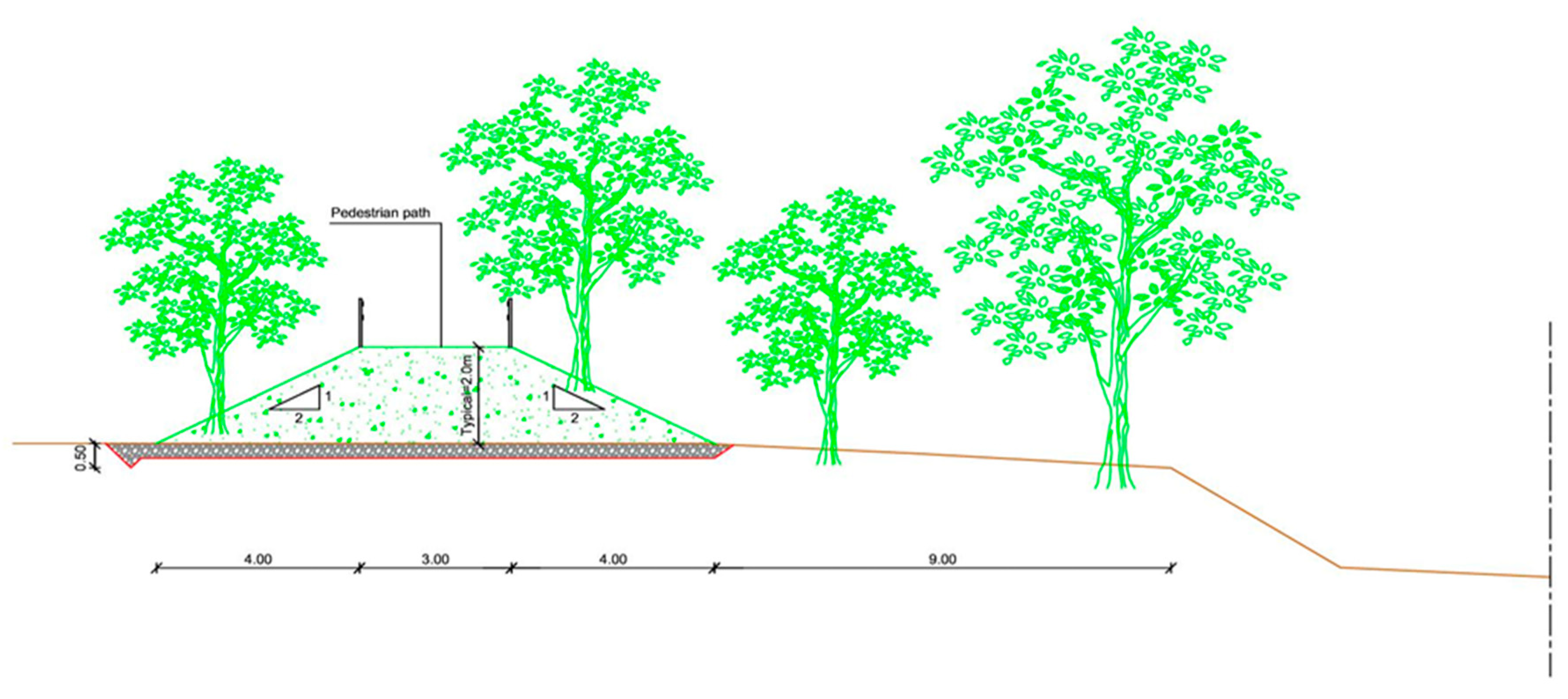
From the regional perspective, the conflict arose with the riparian forest pedestrian path that runs next to the river. Since the path runs with the floodplain, the Region will be responsible for protecting people by preventing them from walking along the path during a flood event. Given that this is a major responsibility which can be prone to mishaps, the Regional representatives, and especially the Technical Services, were suggesting a redesign that would include flood control and an alternative design of the path. Reduction in the flood plain width was also suggested by the Municipal authorities as a way to gain the acceptability of the local stakeholders.
The golden solution to overcome these conflicts was to reduce the flood plain to 20 m on either side of the river by creating a forested levee that would run from the Stylos springs to the Koiliaris River estuary, a distance close to 5 Km. Therefore, the 20 m of riparian forest will comprise a 10-m section and then 10 m for the forested levee. The levee will be about 2 m in height. There will be a 3-m walking path at the top of the levee and trees will be planted on the slopes following the original design. In this way, we can achieve river bank erosion protection, with the creation of 20 m on each side for 5 km riparian forest as well as flood control (
Figure 6). The land owners will give up 20 m of their property; however, the remaining property will increase in value significantly since it could be transferred or sold.
Figure 7 presents the flood zone after the restoration of the riparian forest and the flood protection measures.
The final design was presented to the Municipality Council and the Mayor and had the full support of all the parties. Finally, two open local stakeholder meetings were carried out during the NBS design phase, where all stakeholders participated in order to discuss the final solution and present all the dimensions and issues of the proposed solutions.
3.4. Implementation Phase
The final phase of the decision-making methodology is the implementation step, which includes obtaining approvals from various Departments of the Decentralized Administration of Crete, securing funding, and the continuous assessment and evaluation of the NBS proposed in the design phase.
Regarding governmental approvals, the Environmental Impact Assessment with the proposed design has been submitted to the Department of Environment and Spatial Planning of the Decentralized Administration of Crete to approve and to establish the environmental requirements for the project. The Department will request opinions from the following Departments: Water Division and Forestry of the Decentralized Administration, Ephorate of Antiquities of Chania (Ministry of Culture and Sports), Municipality of Apokoronas Council, and the Environmental and Water Resources Unit of the Regional Unit of Chania. The Department of Environment and Spatial Planning will forward the request and the recommendation to the Regional Council for final approval. Upon approval, the procurement details with the estimated cost will be prepared for the tender.
The second phase of implementation is to secure the funding for the project which is estimated to be around EUR 3 to 3.5 million. The alternative funding mechanisms are the following: a) the project to be included in the funding of the structural funds, or b) to obtain national funding that have been allocated to various Ministries or the Region of Crete. In addition, funding from last year’s emergency disaster funds can be used to complete the project. The Municipality of Apokoronas will work together with Region of Crete to resolve the issue.
Finally, the third phase involves the continuous assessment and evaluation of the NBS by using Key Performance Indicators (KPIs). In order to determine the KPIs that are necessary for the continuous assessment, maintenance and evaluation of the NBS, we need to classify the proposed NBS and determine the NBS approach used, the NBS challenges addressed and the ecosystem services provided. The NBS used in Koiliaris CZO was classified according to the NBS classification scheme which was a result of a synthesis conducted from a literature review and stakeholder consultation and discussion on the ThinkNature platform (
https://platform.think-nature.eu), following four distinct approaches that together identify the uniqueness and usefulness of the NBS [
12]. The NBS used in Koiliaris CZO, according to the degree of intervention and the level of engineering, was classified to the 3rd Type—design and management of new ecosystems, and specifically in the category of the ecological restoration of degraded terrestrial ecosystems. The NBS were further classified into the following NBS types:
Systems for erosion control
Soil and slope revegetation
Plant trees/ hedges/perennial grass strips to intercept surface run-off
Use of pre-existing vegetation
In addition,
Table 2 presents a list of NBS approaches, challenges to be solved and ecosystem services provided related to the NBS proposed for the bank and riparian forest restoration of Koiliaris River. Based on this classification and characterization of the NBS following the ThinkNature project classification, we propose eight indicators for the future monitoring of the NBS performance, that are related to five NBS challenges and are presented in
Table 3.
The project is expected to increase the carbon storage in the area by about 1–2%, reduce the flood up to a maximum hourly flow of 127 m
3/s, increase public health and well-being, as well as provide economic potential and green jobs. The present-day participation of stakeholder involvement is considered exceptional and is expected to be maintained in the future (
Table 3).
The proposed NBS solution offers the following co-benefits:
Protection of the river in a sustainable way.
Improvement of the biodiversity of the river and the riparian area.
Improving the water quality of the river.
Creation of a park of high ecological value.
Improving the quality of life of the local people and social cohesion.
Opportunity for tourism and agriculture cooperation and the creation of new jobs.
Creation of a riparian forest which will be a reference point for the development of unique and high-quality agricultural products and can be used as a marketing tool for their promotion.
It is an exemplary example of a functional ecosystem restoration that can be used for flood and erosion protection in many parts of the world.
The project highlights the determination of the local community and the Municipality of Apokoronas to show that they:
Believe in the sustainable development of the area.
Respect and protect nature.
Demonstrate commitment to sustainable land management and the production of quality products.

 ,
, 


