
The Impact Assessment of Increasing Population Density on Jeddah Road Transportation Using Spatial-Temporal Analysis


Department of Urban and Regional Planning, Faculty of Architecture and Planning, King Abdulaziz University, Jeddah 21589, Saudi Arabia
Sustainability 2021, 13(3), 1455; https://0-doi-org.brum.beds.ac.uk/10.3390/su13031455
Submission received: 8 December 2020
/
Revised: 22 January 2021
/
Accepted: 27 January 2021
/
Published: 30 January 2021
(This article belongs to the Special Issue Rethinking Urban Population Density and Sustainable Cities)
Abstract
:This paper aimed to measure and analyze the impact of temporal population density changes on transportation in Jeddah, a fast-growing city in Saudi Arabia. Local cooperative interpretation is first used to quantify the temporal population density and transportation changes for three sample districts in Jeddah from 2007 to 2014. Three temporal indicators were developed to measure the impact of increasing population density on transportation: (1) District Road Density Index (DRDI); (2) District Parking Index (DPI); and (3) District Trip Index (DTI). Then, a statistical analysis was conducted to examine the temporal relationship between population density and transportation for the years 2007 and 2014, by performing a Pearson correlation analysis, a paired t-test and a bootstrap for paired samples test. The results of temporal indicators revealed a significant change in population density in Jeddah from 2007 to 2014, which seems to indicate intensified demand for transportation infrastructure. The Pearson correlation analysis indicated a strong positive relationship between population density variables and temporal impact indicators. Both a paired t-test and a bootstrap for paired samples test results indicated the effect of population density changes on transportation changes in Jeddah as a result of population density regulation changes in Jeddah from 2007 to 2014. This study presents sophisticated tools to study the impact of temporal population density change on transportation in a fast-growing city, which will facilitate the measurement and evaluation of urban sustainability.
1. Introduction
Cities have been recognized as growth engines for a long time [1]. Rapid urban population growth and the expansion of cities affect other urban systems. Changes in land use policies and, in particular, the increased population density in these cities, undeniably affect other systems such as transportation, as transportation is strongly related to land use [2]. In fact, transportation is among the most significant infrastructures [3] in large cities, and insufficient infrastructure, along with growing population density, might cause serious consequences including the deterioration of existing transportation infrastructure, prolonged traffic, problems with parking, and higher rates of carbon emissions. All of these factors cumulatively result in compromised human and environmental health on the one hand, and economic and social shortfalls on the other. However, the transportation system is also one of the main driving factors behind rapid spatial expansion and urban sprawl, which influence the patterns of urban land use and level of activities’ accessibility [2].
To contain rapid urban expansion in fast-growing cities, changes in the densification of urban areas is one of the main strategies. Undeniably, these strategies will impact on other urban systems, including transportation. Population density has a strong relationship with transportation [4,5,6]. Therefore, the impact of such strategies on transportation must be quantified and analyzed [7]. In fact, there is a lack of research on the temporal effects of population density changes on transportation, particularly in the context of fast-developing and car-dependent cities.
Saudi Arabia is one of the world’s most highly urbanized countries, with more than 80% of people residing in cities [8]. Cities in Saudi Arabia have demonstrated a rapid rate of urbanization due to the high urban population growth. The city of Jeddah has been at the forefront of urban growth. It is a fast-growing polycentric city [2], but its development area has been constrained by several factors including topography, demography, culture, and climate. Perhaps the limitations to urban expansion and compulsion to accommodate more people have compelled urban administrators to change policies in favor of high-rise developments. These limitations on urban expansion in Jeddah have attracted solutions in the form of redevelopment or the renewal of the low-rise. A recent study has assessed the role of large urban development projects as a driving force in land development in Jeddah, in which high-rise, mixed-use development is anticipated [9]. However, considerable changes to urban land development policies are appropriate for accommodating more people in the city fabric, though if the increased density is not matched by increased infrastructure and amenities, this may cause problems.
This paper attempted to measure and analyze the impact of temporal population density change on transportation in Jeddah, a fast-growing and car-dependent city in Saudi Arabia. It strived to examine the impact of vertical growth—because of the decision to change the building code, resulting in increased building heights—on the transportation set-up in Jeddah. This paper is arranged in four subsections that deal with land use and transportation interactions, the challenges of transportation in Saudi Arabian cities, and the scenario in Jeddah pertaining to urban density and transportation. In Section 2, a review of the relevant literature is presented. In Section 3, the data and methods used in this study are described. Section 4 contains the results, and Section 5 discusses the main findings from this research.
2. Literature Review
2.1. Land Use Transport Interactions and Urban Sustainability
Land use and transportation are reciprocally interactive. Many previous studies have proved that land use and transport systems are strongly linked [2,10,11,12]. Land use changes induce significant changes in travel demands and patterns while transportation systems influence patterns of urban land use and the level activities’ accessibility. This reciprocal link is complicated, hence diverse interactions occur on temporal scales and involve variety of factors [13]. It is also a dynamic process that includes spatial and temporal changes between the land use and transportation systems [14]. Urban sustainability is central in land use and transportation interaction. It ensures that cities’ land use and transportation systems are planned in consideration of their environmental, economic and social impacts [15,16]. Thus, it is important to understand the interactions between the land use and transport systems and the environmental, economic and social systems [15]. This is particularly important in cities with high share of the private car mode, which causes high transport usage [17]. In fact, the transport sector is a major driving force of carbon emissions and cannot be isolated from urban development [18].
The comfort level of city residents in terms of residential amenities, including mobility, is an indicator of livability, as has been concluded by studies conducted in many cities around the globe [19,20]. Mobility in a city can be measured by the ease of daily trips related to work or nonwork activities. An upsurge in the demand for housing might also be translated into rising mobility demand in a city. In countries where high-density residential development has been supported by mass transit amenities, urban planning and development will be more sustainable [21]. High-rise buildings are anticipated to be an alternative to urban sprawl; thus, sprawl might be effectively controlled through a space‒transport integrated strategy [22].
An integrated land use and transport system is in urgent need to guarantee a higher level of livability and sustainability [23,24]; this plan should also be consistent with the regional economic development plan [25]. Moreover, by calculating land use and transportation interactions, the impact of land use and transport planning on travel patterns might be predicted [26,27]. The outcomes of land use and transport modeling encourage proactive sustainable planning [28]. Each change in the land use pattern affects the transportation system, and vice versa. Therefore, attention should be paid to patterns of mutual confluence [29], aiming to develop a comprehensive approach to attaining the targets of a sustainable transportation agenda [30].
2.2. Transportation Issues in Saudi Cities
Saudi Arabia has witnessed dramatic economic and urban growth because of the oil boom; the revenue from oil has notably increased and has significantly improved the income and lifestyle of Saudi families [31]. The economic growth consequently caused a massive expansion of urban communities and urban centers. Urban expansion was further translated into increased reliance on private cars for commuting in urban areas to accomplish daily work and nonwork activities. Thus, the share of private cars in daily travel is large in Saudi cities.
In essence, a few decades ago, there was no problem with space for parking cars in Saudi cities; however, it has since become a grave challenge for officials working in the transport department as a result of the continuous rapid population growth and private car dependency. Currently, car parking has become a major part of urban transportation planning challenges in Saudi Arabian cities. The lack of car parking integration with the zoning regulations and land use planning has stimulated transportation problems in Saudi cities [32]. The absence of an effective public transport system is also a major issue in Saudi cities [33]. Except for Riyadh, which has an underdeveloped public transport system, major cities, such as Jeddah and Dammam, have totally undeveloped public transport systems in terms of coverage, comfort, and acceptability [34]. Undeniably, this must be addressed when considering high-density urban expansion.
2.3. The Urban Density and Transportation in Jeddah
Saudi cities face traffic congestion and emission challenges [35] because of the failure of policy to address increased population density when planning transportation infrastructure. Jeddah, which is the second-largest city in the kingdom, is no exception.
The urban planning of Jeddah can be classified into three phases, as follows:
- The traditional walled city existed until 1947.
- Unplanned urban development (1947‒1960).
- Planned urban development (1960 until the present).
It is believed that during the first phase, the city was more pedestrian friendly, while the activities of residents were limited to the walled territory; thus, challenges of transportation were limited. The second phase of urban development was a result of the oil boom, which boosted the city’s development but resulted in urban sprawl. The dramatic change in per capita income made Jeddah a center of employment, attracting significant internal and external migration. It has also increased residents’ dependence on cars for mobility; however, in this phase, public transportation was adequately available [31,36].
The real issues started in the third phase of urban development, when most of the road infrastructure was built, some districts started to encounter vertical growth, and public transport amenities deteriorated. As noted earlier, the fast development of the city was a result of the rapid population growth, which also accelerated the growth of the economy. Though the constraints of the development area negatively affected the supply of land for residential needs, increased density tends to affect the quality of mobility across the city.
Therefore, during the past four or more decades, urban planners and policymakers in Jeddah have ineffectively coped with mobility challenges such as the mismatch between urban growth, transportation amenities and growing traffic [37]. Unfortunately, the absence of a rapid mass public transport system in Jeddah is the most persistent problem hampering sustainable development in the city [38]. In fact, Jeddah transport and mobility are characterized by a high level of car dependency, in which 93% of daily trips are commuted by car, while only 7% commuted by public transport, walking, and cycling trips—accumulatively [2]. According to Smith [39], there are some other factors that stimulate the increased density of urban areas, including the age of the city, its historical evolution, the physical setting, and the culture, economy, and transport technology. The extreme climatic conditions in Jeddah prevent high-density development; consequently, brownfield development was not an integrated part of urban growth policies until 2000. However, a local plan in 2007 paved the way to increase the height of existing buildings.
At present, the residential density in Jeddah has been increasing because of the conversion of low-rise buildings into high-rise buildings; in particular, apartments are the center of attention. Experience from fast-growing global cities suggests that any such development aimed at increasing density (vertical growth by increasing the height of residential buildings) should be supported by an efficient and reliable transportation infrastructure, including an appropriate volume of roads, parking lots, road quality, and a mass rapid public transport system [40]. Accordingly, this paper attempted to analyze the temporal population density change’s impact on transportation in Jeddah.
3. Materials and Methods
3.1. Study Area
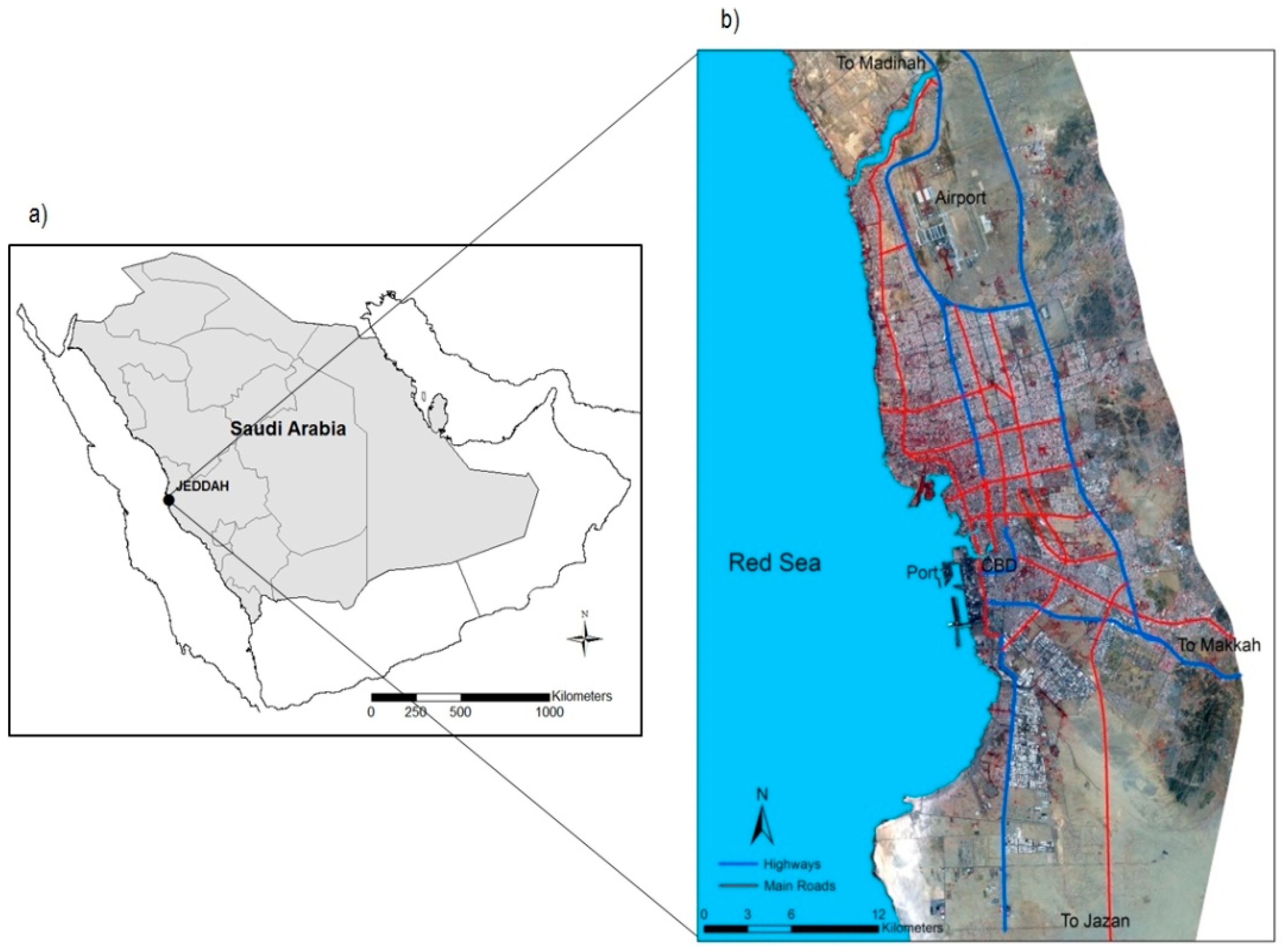
Known as the “Bride of the Red Sea” [39], Jeddah is the second largest and most cosmopolitan city of the Kingdom of Saudi Arabia; the city is in Makkah province, located on the coast of the Red Sea (see Figure 1). The city of Jeddah serves as the gateway to the holy city of Makkah, where millions of Muslim pilgrims from the whole world come every year to perform Hajj and Umrah. The city has 3.4 million inhabitants (as of 2014), spread over a geographical area of 748 km2 [41]. The city is well known for its strategic importance and diverse culture, and as a hub for educational, commercial, and health services. Additionally, Jeddah is well connected to most of the world through King Abdul-Aziz International Airport (the headquarters of Saudi Arabian Airlines) and Jeddah Islamic Port.
3.2. Temporal Data Quantification
3.2.1. Data Acquisition and Collection
Many previous urban studies have considered population density as crucial in analyzing spatial and temporal urban growth and transportation interaction [6,42,43]. This reflects the pattern and characteristics of this interaction and calculated as the total population to the total area. This study incorporated several types of spatial and temporal data for quantifying the temporal population density and transportation changes. Two spot satellite images for Jeddah in 2007 and 2014 were used in conjunction with the time-lapse feature in Google Earth Pro. In addition, secondary data were collected to facilitate the analysis of temporal population density and transportation changes in Jeddah from 2007 to 2014. These data include master plans, census data, zoning, policies, and local guideline documents.
3.2.2. Local Cooperative Visual Interpretation
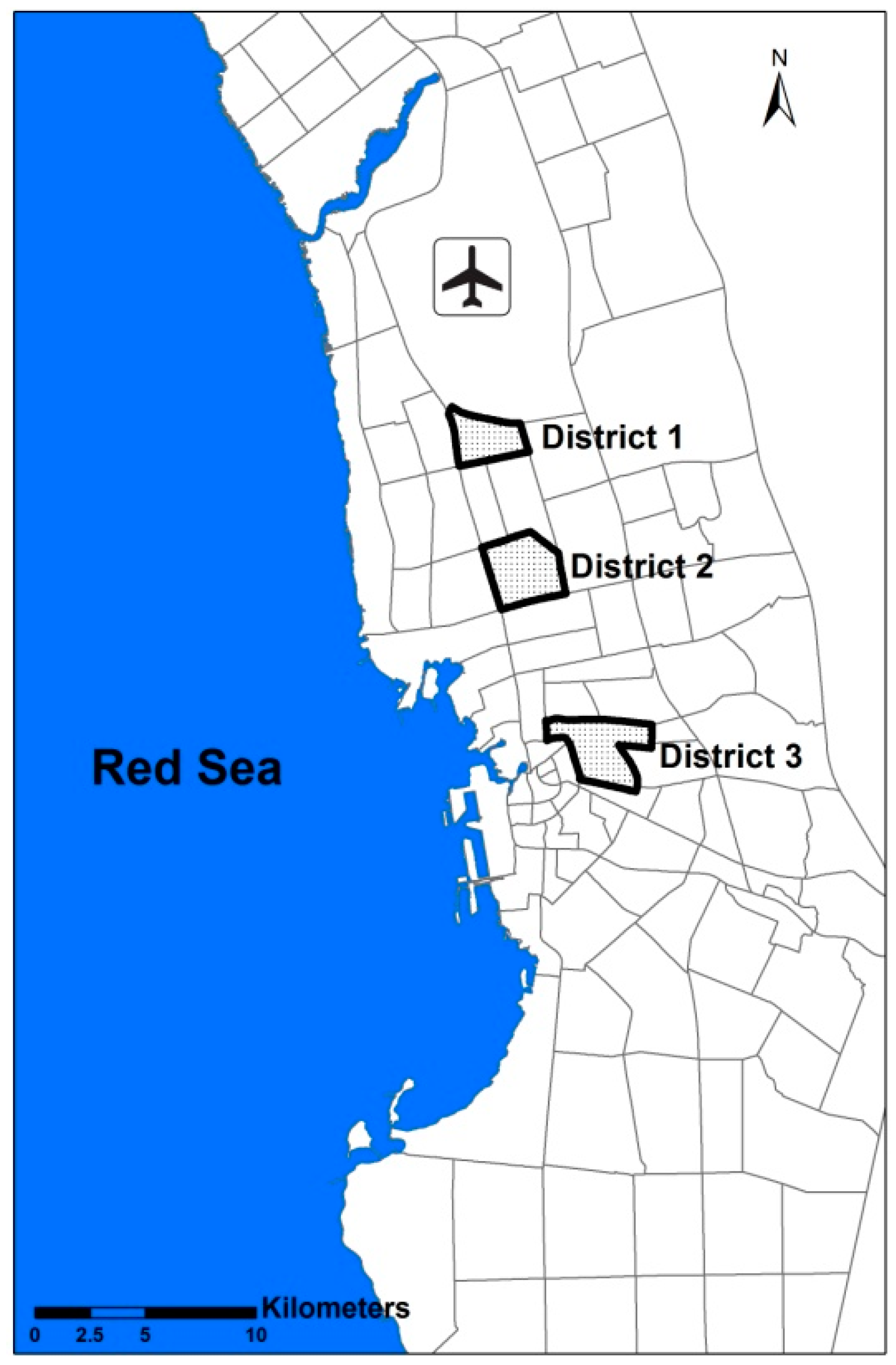
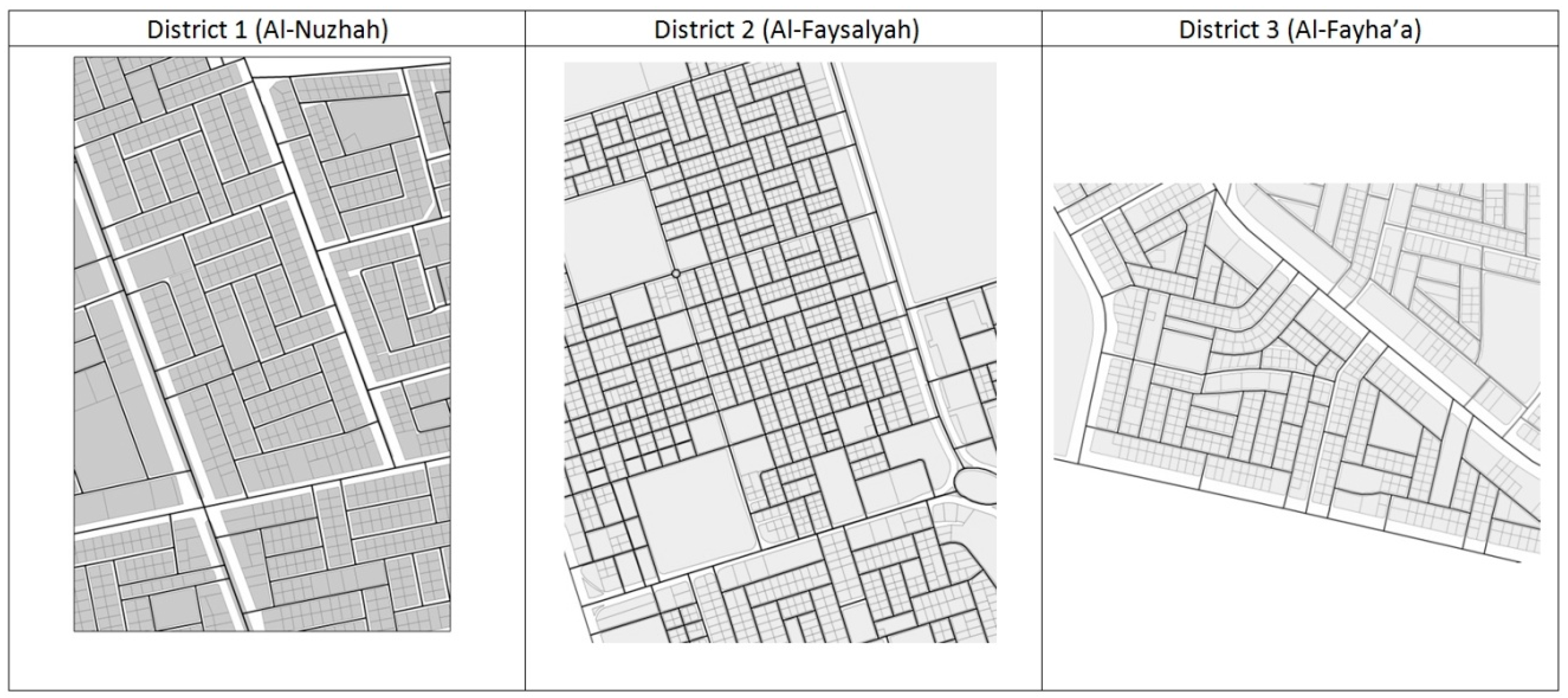
To identify temporal density changes, three sample districts where low-rise buildings were expanded into high-rise buildings over the past seven years were initially selected (Figure 2). These sample districts were selected based on variation in density and locations to ensure reasonable representation. District 1 is Al-Nuzhah district, located in north Jeddah with medium to high population density. It is characterized by rectangular blocks with a straight street pattern (Figure 3). District 2 is Al-Faysalyah district, located in the middle of Jeddah, with a moderate population density and which is characterized by a square-shaped grid street pattern with a high number of intersections, as depicted in Figure 3. On the contrary, District 3 is Al-Fahya’a district, which comprises quite a low population density and is characterized by organic lengthy building blocks with a curved street pattern, and a low number of intersections (Figure 3).
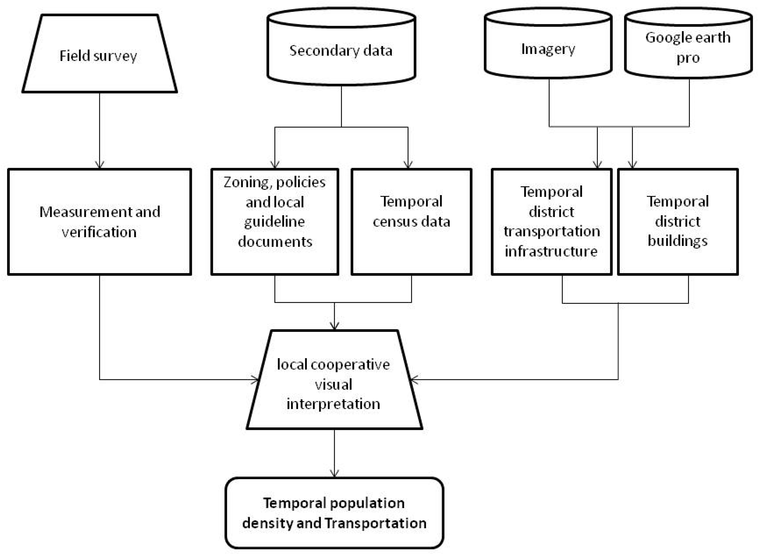
Then, local cooperative visual interpretation (Figure 4) was utilized to quantify the temporal population density and transportation changes in these districts from 2007 to 2014. Cooperative interpretation is a method whereby experts work with computers to interpret remote sensing imagery data [44]. This method combines the computer’s automatic interpretation, secondary data, and human experience [45]. It has been widely used in urban applications with high accuracy [44,45]. Remote sensing data can be interpreted either visually by human experts or automatically by digital image processing and pattern recognition methods [46]. However, combining human knowledge and computer processing will be more conducive to the extraction of information from remote sensing data [45].
The local cooperative visual interpretation started with the extraction of subset images of each district from the two spot satellite images for Jeddah in 2007 and 2014. Then, built-up and non-built-up areas were defined in conjunction with Google Earth. After that, secondary data on population density and transportation were integrated with the built-up and non-built-up area findings, using the overlay function in ArcGIS. This coincided with a field survey and verification. Consequently, a final local interpretation was conducted, incorporating all the aforementioned processes in ArcGIS v10.3 using on-screen digitizing, overlay tools, and area of interest (AOI) functionality. Accordingly, population density and transportation infrastructure maps and data for the three districts were obtained for 2007 and 2014 as follows: residential buildings for 2007 and 2014, population for 2007 and 2014, population density for 2007 and 2014, transportation infrastructure for 2007 and 2014, and average residential buildings heights for 2007 and 2014.
3.3. Temporal Indicators
Indicators are effective tools to measure and analyze the impact of population growth and density increase on transportation. Accordingly, three indicators were developed in this study to measure the impact of increasing population density on transportation.
3.3.1. District Road Density Index
The road density index is needed to study the deficiencies in road infrastructure compared with the population [2]. This index has been adopted to measure the length of roads per number of inhabitants over each district and is defined as follows:
where (m/person) is the district road density index for district a; . is the total road length in m for district ; and UPa is the total population of district .
2.3.2. District Parking Index
The district parking index was developed to measure the effects of increased building heights on parking. It calculates the total residential floor area per district in relation to the required number of parking spaces per district and is defined as follows:
where (parking) is the district parking index for district ; is the total residential floor area (in m2) for district ; is the municipality standard for parking in district residential houses; is the average height (number of floors) of residential houses for district ; and is the average floor area of residential houses for district .
The average height (number of floors) of residential houses in the three districts was observed during the field survey and calculated based on the observed built-up ratio of several residential houses samples per district multiplied by the total residential parcels per district, which was collected through secondary data from a geographic information system (GIS). Finally, the municipality standard for parking by district residential houses was considered to be one parking space per 150 square m on the basis of the Jeddah city local plan [47].
3.3.3. District Trip Index
The district trip index was developed to measure the effects of increased population density on travel demand. It calculates the total residential floor area per district and number of generated trips per district, defined as follows:
where (trips) is the district trip index for district ; is the total residential floor area (in square m) for district ; and is the trip production rate of district residential houses.
The total residential floors areas (in square m) are the same as those that have been calculated in DPI. The trip production rate for residential houses was adopted from the Trip Generation Manual for Riyadh [48]. The rate is 0.73 trips per 100 square meters of residential houses for morning peak hours and 0.77 trips per 100 square m of residential houses for evening peak hours, as indicated by the manual [48].
3.4. Statistical Analysis
To examine the temporal relationship between population density and transportation for two years—2007 and 2014—statistical analysis was conducted in SPSS. Population density is defined using four variables: population growth, population density, total residential floor area (m2), and average building height. Conversely, transportation is defined by the temporal impact indicators. First, a Pearson correlation analysis was performed to determine the relationship between population density and transportation. Population density variables and temporal indicators for the three districts were combined for two years (2007 and 2014) to determine the relationship between population density indicators and transportation indicators.
Second, a paired t-test was performed on the combined population density variables and temporal impact indicators for two years (2007 and 2014) to examine the temporal effects of the change in Jeddah’s population density regulation on the district’s transportation. Prior to that, paired sampled correlations were investigated to ensure the significance of the paired samples. This test was considered to understand whether changes in population density variables and temporal indicator differences from 2007 and 2014 were statically significant.
Finally, a bootstrap for a paired samples test based on 1000 bootstrap samples was performed on the combined population density variables and temporal impact indicators for two years (2007 and 2014) to further examine the temporal impact of Jeddah’s population density regulation changes on the district’s transportation. This test is a computer-based resampling method which has higher statistical capabilities [49,50]. It is easy to understand and free of the restrictive assumption regarding the normality of sample data [51]. It has been applied to many previous studies of spatial and temporal analysis [52] and in urban and transport [50].
4. Results
4.1. Temporal Changes
The results indicate that during the period 2007‒2014, the population density in the three districts witnessed significant change. Table 1 reveals that, in all three sampled districts, the number of floors increased from 3 to 6‒7. An upsurge in building height has changed the skyline of these districts and increased the population density in all three sampled districts. The results also indicate that the population density has changed drastically in all the sampled districts. Districts 1 and 2 have witnessed an approximately 28% increase in population density, whereas District 3 witnessed an increase of approximately 24%. The results indicate a significant change in population density in the three districts over a short period of time. This has been triggered by the change in the Jeddah city local plan in 2007 in which it paved the way to increase the height of existing buildings.
4.2. Temporal Indicators
4.2.1. District Road Density Index (DRDI)
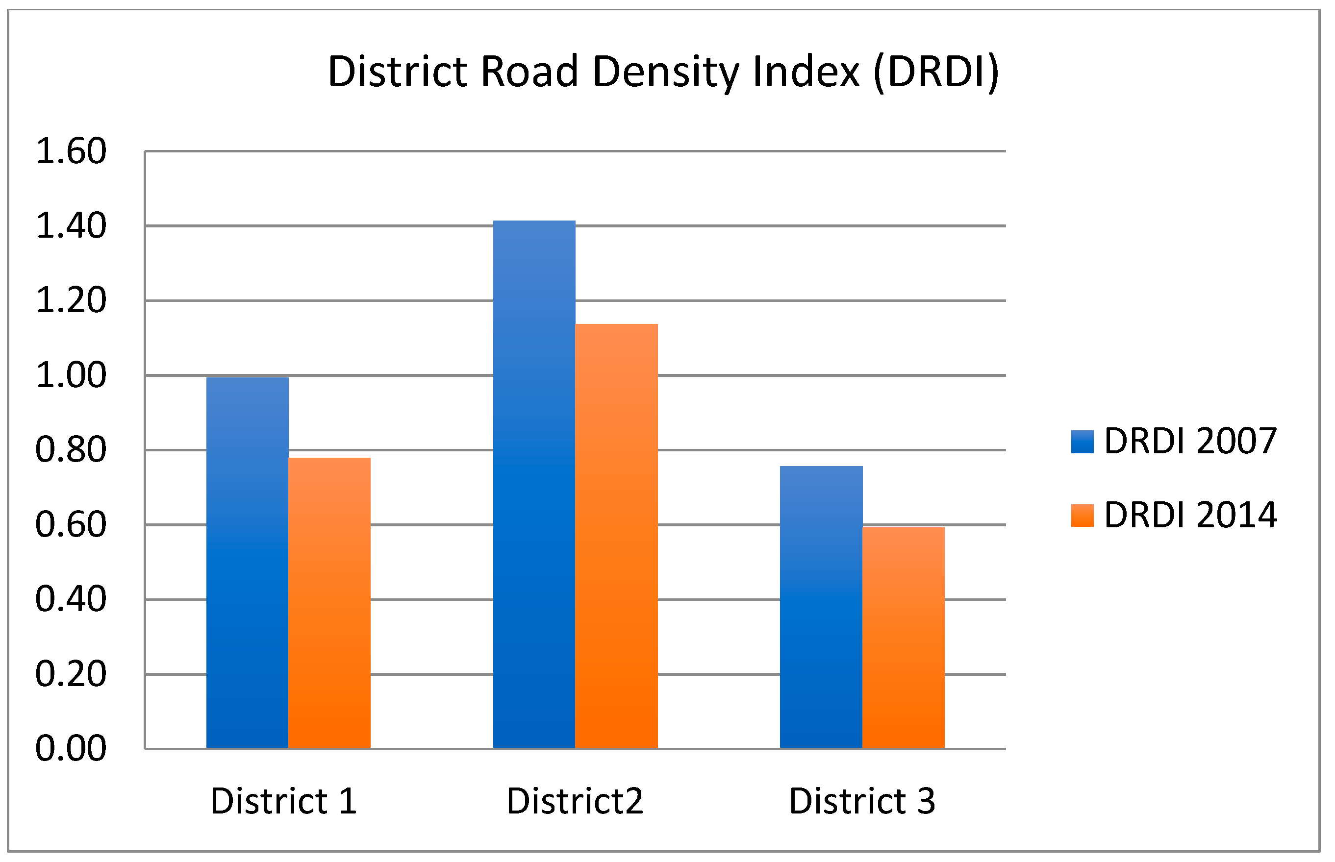
Table 2 and Figure 5 depict the results of the district road density index. In general, the district road density index reveals a decrease in the three districts as a result of population growth because of the density increase. It is noticed that the District 1 road density index declined from 0.99 m/person in 2007 to 0.78 m/person in 2014, a −21.7% change. The District 3 road density index declined from 0.76 m/person in 2007 to 0.59 m/person in 2014, a similar change to District 1, whereas the District 2 road density index declined from 1.41 m/person in 2007 to 1.14 m/person in 2014, a −19.6% change.
Interestingly, there seems to be a general trend of road density decline with a similar percentage of change. This seems to be catalyzed by the increase in population in these districts as a result of the change in building heights regulation as approved in the Jeddah city local plan in 2007. As a result, the designed road infrastructure capacity for these districts for 2007 and before witnessed a significant change which certainly will affect its performance. This is notable given the dominance of the share of private vehicle in daily trips in Jeddah city and the absence of efficient public transportation in Jeddah.
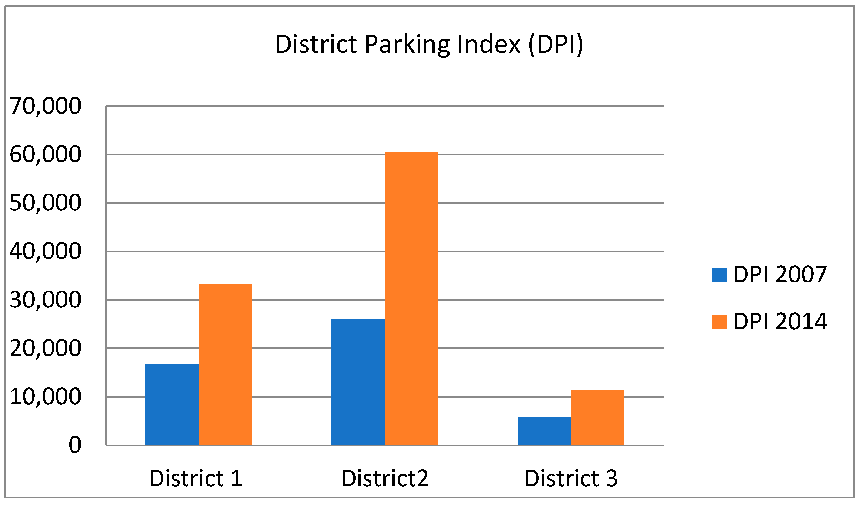
4.2.2. District Parking Index (DPI)
Table 3 and Figure 6 show the results of the district parking index. Generally, the district parking index indicates a high increase for the three districts as a result of population growth and increased density. It is noted that the District 2 parking index dramatically increased from 25,921 parking spaces in 2007 to 60,482 parking spaces in 2019, a 133% change. This district represents the highest change in this index. Table 3 and Figure 6 reveal that the District 1 parking index also notably increased, from 16,638 parking spaces in 2007 to 33,276 parking spaces in 2019, a 100% change. The District 3 parking index also significantly increased, from 5713 parking spaces in 2007 to 11,426 parking spaces in 2019, a similar change (100%) to District 1.
This index highlights the high impact of population growth and density increase on transportation. Parking has a central role in transportation system. Demand for parking in the three districts seems to be notably increased from 2007 to 2014. This coincided with the lack of notable parking interventions in the three districts. Hence, parking management and integration with the zoning regulations in Jeddah city local plan in 2007 are lacking. Undeniably, the lack of the efficient management of parking demand considerably contributes to urban congestion [53].
4.2.3. District Trip Index (DTI)
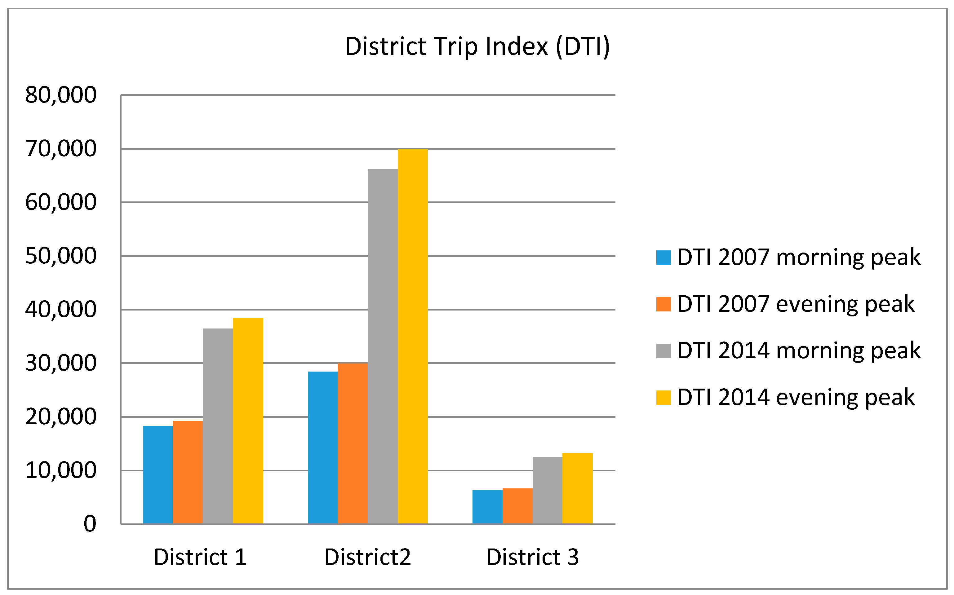
Table 4 and Figure 7 illustrate the results of the district trip index. This index indicates a high increase in the estimated trip productions for the three districts as a result of population growth and density increase. Notably, District 2 represents the highest change in this index as the estimated trip productions of morning peak trips increased from 28,383 trips in 2007 to 66,228 trips in 2019, a 133% change, and the estimated trip productions of evening peaks trips increased from 29,939 in 2007 to 69,857 in 2019, the same percentage of change. The District 1 and District 3 trip indexes also significantly increased, with a 100% increase in the estimated morning and evening peak trip productions alike, as depicted in Table 4 and Figure 7.
Interestingly, this index points to the high impact of population growth and density increase on transportation. The large increase in both morning peak and evening peak estimated trip productions indicates the increased travel demand, which seemed to cause a large increase in traffic pressure on the transportation infrastructure in the three districts. This also coincided with a high dependency on private cars as the main mode of transport in the three districts.
4.3. Statistical Analysis
4.3.1. Pearson Correlation Analysis
The results indicate a strong correlation between population density variables and temporal impact indicators (see Table 5). In general, a significantly positive relationship was found. The population and total residential floor area variables seem to have a strong correlation with temporal indicators, where DRDI, DPI, DTIa, and DTIb had a 0.646, 0.888, 0.894, and 0.888 correlation coefficient with the population variable, respectively. Also, DPI, DTIa, and DTIb had 1.00, 0.99, and 1.00 correlation coefficients with the total residential floor area variable. Conversely, the population density and average building height variables seem to have a moderate relationship with DPI, DTIa, and DTIb and a lower relationship with DRDI.
4.3.2. Paired t-Test
A paired t-test was conducted to the compare the population densities variables and temporal indicators in 2007 before the implementation of the Jeddah city 2007 local plan and in 2014, after the implementation of the plan. Results indicated significant changes for Pair 4 and Pair 5 of (p = 0.010) and (p = 0.018), respectively, as indicated in Table 6. This indicates that the population density regulation changes in Jeddah from 2007 to 2014 seemed to match the change in building height. This also seems to indicate that the change in population density regulations notably affected the transportation infrastructure in the three districts, as indicated by the significant change in DRDI (p = 0.018) from 2007 to 2014.
4.3.3. Bootstrap for Paired Samples Test
The bootstrap for a paired samples test based on 1000 bootstrap samples indicated significant changes for Pair 3, Pair 4, Pair 5, and Pair 7, as indicated in Table 7. A notable change in DRDI and DTIa (p = 0.001) from 2007 to 2014 was found after the implementation of the Jeddah city 2007 local plan. This coincided with a notable change in population density and average building height (p = 0.001 and p = 0.002, respectively) from 2007 to 2014. Interestingly, the increased sampling seemed to confirm the significant impact of population density regulation changes in Jeddah from 2007 to 2014 on temporal indicators and thus seemed to reveal the effect of population density changes on transportation changes in Jeddah.
5. Discussion
Temporal indicators result indicated a significant change in population density in Jeddah from 2007 to 2014. This change seems to amplify demands for transportation infrastructure as DRDI indicates a significant decline in the three districts, whereas DTI indicates a large increase. The district parking index also seems to indicate a large increase in parking demand as a result of population density changes.
Statistical analysis results also indicate an interaction between population density changes and transportation. A strong positive relationship between population density variables and temporal indicators is indicated by the Pearson correlation analysis (Table 5). Paired t-test results (Table 6) also reveal that the change in population density regulations after the implementation of the Jeddah city 2007 local plan has notably affected transportation infrastructure in the three districts, as indicated by the significant change in DRDI from 2007 to 2014. The bootstrap for the paired samples test based on 1000 bootstrap samples (Table 7) also revealed an interaction between population density and transportation in the three districts. A notable change in DRDI and DTIa from 2007 to 2014 was found and coincided with the notable changes in population density and average building height from 2007 to 2014. It is observed that increased sampling seems to emphasize the significant impact of population density regulation changes in Jeddah from 2007 to 2014 on temporal indicators. Thus, an effect of population density changes on transportation changes in Jeddah is revealed.
The results of this study reveal that changes in population density significantly affect transportation. Therefore, transportation planning should not be overlooked while making decisions on changes in population density. In fact, the impact of population density changes on transportation must be studied and analyzed [7,54], particularly in fast-growing cities where effective public transportation is absent and cars are prevalent, as in Jeddah. The negative impacts of the use of private vehicles are well known worldwide, but in Jeddah, car ownership has continued to increase rapidly. Cars have become an indispensable part of city life in Jeddah. It has been widely argued that cars’ domination of the city is in existence due to the absence of a rapid mass public transportation system. Experience from the fast-growing global cities suggests that any such development aimed at increasing density (vertical growth by increasing the heights of residential buildings) should be supported by an efficient and reliable transportation infrastructure inclusive of the appropriate volume of roads, parking lots, road quality, and a mass rapid public transport system [40] that will create haphazard issues neither for city livability or sustainability. Previous studies pointed out that cities with a high population density will have a lower congestion if the public transport infrastructure per person ration is high [55]. Accordingly, it is crucial to establish an efficient, affordable and comfortable mass rapid public transport system in Jeddah city by espousing the integrated approach to planning, in which land use and transportation both are well synchronized. This will eliminate the negative impact of the implementation of the Jeddah city 2007 local plan and ensure sustainable and livable urban environment.
This study shows that local cooperative interpretation, temporal impact indicators, and statistical analysis are sophisticated tools to study the temporal population density change’s impact on transportation in the case of a fast-growing and car-dependent city. These tools were able to identify and analyze the temporal impact of population density change on transportation. Undeniably, this enriches our insight and extends the knowledge of the temporal effects of population density changes on transportation, particularly in the context of fast-developing and car-dependent cities. In fact, in the process of urban sustainability assessment, there is a need for measurable indicators [56]. The developed temporal indicators in this study facilitate the measurement of population densities change impact on transportation. It can inform the urban and transportation planner with issues and concerns regarding the consequences of new local plans and policies. However, a temporal analysis of the factors driving urban growth, such as population density, and their potential effects on transportation, is crucial to predict future changes and mitigate future consequences [2,57].
This study provides urban and transportation planners with a new practical approach to analyze the complex temporal population density change policy in rapidly growing cities and to evaluate urban sustainability. In essence, urban planners and policy makers require a simple measure to understand land use-transport policy implications [2]. The ability of this approach to measure the impact of the implementation of local plans that encourage population density change facilitates the understanding and evaluation of the complex land use transportation interactions and urban sustainability. This approach can be utilized in early planning stages which can eliminate the gap between land use and transportation plans and policies and facilities by integrating policies and plans which in turn provide a sustainable and livable urban environment [58,59].
6. Conclusions
Jeddah city has witnessed a dramatic change in population densities as a result of the implementation of the Jeddah city 2007 local plan. This has resulted in a significant temporal change of population densities in the three sampled districts from 2007 to 2014 and seems to have caused a significant change in transportation after 2007. Statistical analysis results depict an interaction between population densities changes and transportation. A strong positive relationship between population densities variables and temporal indicators was revealed. It was found that change in population density regulations after the implementation of the Jeddah city 2007 local plan has notably affected transportation infrastructure in the three sampled districts.
This study indicates the unsustainable land use and transportation planning practice in Jeddah, wherein the Jeddah city 2007 local plan was implemented in isolation from any transportation intervention. In conjunction with this, Jeddah is a highly car-dependent city which lacks an effective public transport system. Accordingly, urban sustainability is disrupted in Jeddah. To address these issues, urban and transportation planners in Jeddah require a practical and simple measurement of urban sustainability that can be used to evaluate the consequences of new local plans and policies in early planning stages. This study introduced sophisticated tools to study the impact of the temporal change in population densities impact on transportation and a new practical approach to evaluate urban sustainability.
Although the study approach provided significant information about the temporal impact of population density change on transportation, further studies are highly recommended to validate this approach in other districts in Jeddah city and to include recent data with more temporal lag. It is also recommended to investigate this approach in other fast-growing cities with an efficient public transportation system. Furthermore, the analysis of further relevant population densities variables and impact indicators must be considered.
Funding
This project was funded by the Deanship of Scientific Research (DSR), King Abdulaziz University, Jeddah, under grant no. (DF-827-137-1441). The author, therefore, gratefully acknowledges DSR’s technical and financial support.
Institutional Review Board Statement
Not applicable
Informed Consent Statement
Not applicable
Data Availability Statement
Data sharing is not applicable to this article.
Conflicts of Interest
The author declares no conflict of interest.
References
- World Bank. World Development Report 2000/2001: Attacking Poverty; World Bank Group: Washington, DC, USA, 2000; Available online: http://ina.bnu.edu.cn/docs/20140606092223219839.pdf (accessed on 10 October 2019).
- Aljoufie, M. Toward integrated land use and transport planning in fast growing cities: Case of Jeddah city, Saudi Arabia. Habitat Int. J. 2014, 41, 205–215. [Google Scholar] [CrossRef]
- Kaewunruen, S.; Sussman, J.M.; Matsumoto, A. Grand challenges in transportation and transit systems. Front. Buil. Environ. 2016, 2, 4. [Google Scholar] [CrossRef] [Green Version]
- Handy, S.; Mokhtarian, P. Which comes first: The neighborhood or the walking? Spring: New York City, NY, USA, 2005. [Google Scholar]
- Brownstone, D.; Golob, T.F. The impact of residential density on vehicle usage and energy consumption. J. Urban Econ. 2009, 65, 91–98. [Google Scholar] [CrossRef] [Green Version]
- Aljoufie, M.; Zuidgeest, M.; Brussel, M.; Van Maarseveen, M. Spatial–temporal analysis of urban growth and transportation in Jeddah City, Saudi Arabia. Cities 2013, 31, 57–68. [Google Scholar] [CrossRef]
- Palm, M.; Gregor, B.; Wang, H.; McMullen, B.S. The trade-offs between population density and households׳ transportation-housing costs. Transp. Policy 2014, 36, 160–172. [Google Scholar] [CrossRef]
- United Nations Human Settlements Programme. The State of the Arab cities 2012: Challenges of Urban Transition. United Nations Human Settlements Programme-Flagship Report 2012. Available online: http://unhabitat.org/books/the-state-of-arab-cities-2012-challenges-of-urban-transition/ (accessed on 10 October 2019).
- Abdulaal, W.A. Large urban developments as the new driver for land development in Jeddah. Habitat Int. 2012, 36, 36–46. [Google Scholar] [CrossRef]
- Harris, B. Science in planning: Past, present, future. J. Am. Plan. Assoc. 1994, 60, 31–34. [Google Scholar] [CrossRef]
- Wegener, M. Overview of land-use transport models. In Handbook of Transport Geography and Spatial Systems; Emerald Publishing Limited: Bingley, UK, 2004. [Google Scholar]
- Alonso, A.; Monzón, A.; Wang, Y. Modelling Land Use and Transport Policies to Measure Their Contribution to Urban Challenges: The Case of Madrid. Sustainability 2017, 9, 378. [Google Scholar] [CrossRef] [Green Version]
- Chang, J.S. Models of the Relationship between Transport and Land-use: A Review. Transp. Rev. 2006, 26, 325–350. [Google Scholar] [CrossRef]
- Shaw, S.-L.; Xin, X. Integrated land use and transportation interaction: A temporal GIS exploratory data analysis approach. J. Transp. Geogr. 2003, 11, 103–115. [Google Scholar] [CrossRef]
- Geurs, K.T.; Wee, B.V. Land-use/transport Interaction Models as Tools for Sustainability Impact Assessment of Transport Investments: Review and Research Perspectives. Eur. J. Transp. Infrastruct. Res. 2004, 4, 333–355. [Google Scholar]
- United Nations. The Sustainable Development Goals Report; UN: New York, NY, USA, 2016. [Google Scholar]
- Dingil, A.E.; Schweizer, J.; Rupi, F.; Stasiskiene, Z. Updated Models of Passenger Transport Related Energy Consumption of Urban Areas. Sustainability 2019, 11, 4060. [Google Scholar] [CrossRef] [Green Version]
- Zhao, J.; Xiao, L.; Tang, L.; Shi, L.; Su, X.; Wang, H.; Song, Y.; Shao, G. Effects of spatial form on urban commute for major cities in China. Int. J. Sustain. Dev. World Ecol. 2014, 21, 361–368. [Google Scholar] [CrossRef]
- Black, J. Higher Density Housing and Transport in Australian Cities. In Transport, Land-Use and the Environment. Transportation Research, Economics and Policy; Hayashi, Y., Roy, J., Eds.; Springer: Boston, MA, USA, 1996; pp. 50–80. [Google Scholar]
- Kemeny, J. Comparative housing and welfare: Theorising the relationship. J. Hous. Built Enviorn. 2001, 16, 53–70. [Google Scholar] [CrossRef]
- Smith, W.S. Mass transport for high-rise high-density living. J. Transp. Eng. 1984, 110, 521–535. [Google Scholar] [CrossRef]
- Lasmini, A.; Verhaeghe, R.; Pel, A.J.; van Arem, B. Controlling Urban Sprawl with Integrated Approach of Space-transport Development Strategies. Procedia-Social and Behavioral Sciences. Procd. Soc. Behv. 2014, 138, 679–694. [Google Scholar]
- Badoe, D.A.; Miller, E.J. Transportation–land-use interaction: Empirical findings in North America, and their implications for modeling. Transp. Res. D Tr. E 2000, 5, 235–263. [Google Scholar] [CrossRef]
- Wegener, M. Land-use transport interaction models. In Handbook of Regional Science, 1st ed.; Fischer, M.M., Nijkamp, P., Eds.; Springer: Berlin/Heidelberg, Germany, 2014; pp. 741–758. [Google Scholar]
- Beimborn, E.; Horowitz, A.; Vijayan, S.; Bordewin, M. An Overview: Land Use and Economic Development in Statewide Transportation Planning, Center for Urban Transportation Studies; University of Wisconsin: Milwaukee, WI, USA, 1999. [Google Scholar]
- Chatman, D.G. Estimating the effect of land use and transportation planning on travel patterns: Three problems in controlling for residential self-selection. J. Transp. Land Use 2014, 7, 47–56. [Google Scholar] [CrossRef] [Green Version]
- De Vos, J. The influence of land use and mobility policy on travel behavior: A comparative case study of Flanders and the Netherlands. J. Transp. Land Use 2015, 8, 171–190. [Google Scholar] [CrossRef] [Green Version]
- Nijkamp, N.; Borzacchiello, M.; Ciuffo, B.; Torrieri, F. Sustainable Urban Land Use and Transportation Planning: A Cognitive Decision Support System for the Naples Metropolitan Area. Int. J. Sustain. Transp. 2007, 1, 91–114. [Google Scholar] [CrossRef]
- Onsted, J.A.; Chowdhury, R.R. Does zoning matter? A comparative analysis of landscape change in Redland, Florida using cellular automata. Landsc. Urban Plan. 2014, 121, 1–18. [Google Scholar] [CrossRef]
- Mattioli, G. Where Sustainable Transport and Social Exclusion Meet: Households Without Cars and Car Dependence in Great Britain. J. Environ. Pol. Plan. 2014, 16, 379–400. [Google Scholar] [CrossRef] [Green Version]
- Al-Hathloul, S.; Mughal, M.A. Urban growth management-the Saudi experience. Habitat Int. 2004, 28, 609–623. [Google Scholar] [CrossRef]
- Al-Fouzan, S.A. Using car parking requirements to promote sustainable transport development in the Kingdom of Saudi Arabia. Cities 2012, 29, 201–211. [Google Scholar] [CrossRef]
- Aljoufie, M.; Tiwari, A. Exploring Housing and Transportation Affordability in Jeddah. Hous. Policy Debate 2020. [Google Scholar] [CrossRef]
- Alotaibi, O.; Potoglou, D. Introducing public transport and relevant strategies in Riyadh City, Saudi Arabia: A stakeholders’ perspective, Urban. Plan. Transp. Res. 2018, 6, 35–53. [Google Scholar] [CrossRef]
- Rahman, S.M.; Khondaker, A.N.; Hasan, M.A.; Reza, I. Greenhouse gas emissions from road transportation in Saudi Arabia-a challenging frontier. Renew. Sust. Energ. Rev. 2017, 69, 812–821. [Google Scholar] [CrossRef]
- Daghistani, A.M.I. Urban growth management in Jeddah. Plan. Out. 1991, 34, 2–9. [Google Scholar] [CrossRef]
- Aljoufie, M.; Brussel, M.; Zuidgeest, M.; van Delden, H.; van Maarseveen, M. Integrated analysis of land-use and transport policy interventions. Transport. Plan. Techn. 2016, 39, 329–357. [Google Scholar] [CrossRef]
- Shaker, A. The Feasibility of Implementing Public Transportation in Jeddah. Master’s Thesis, Ball State University, Muncie, IN, USA, 2014. [Google Scholar]
- Smith, G.R.; Umar al Zayla’i, A. Bride of the Red Sea: A 10th/16th century account of Jeddah. Working Paper, University of Durham, Centre for Middle Eastern and Islamic Studies, Durham 1984. Available online: http://dro.dur.ac.uk/139/1/22CMEIS.pdf (accessed on 15 May 2020).
- Fouracre, P.; Dunkerley, C.; Gardner, G. Mass rapid transit systems for cities in the developing world. Transport. Rev. 2003, 23, 299–310. [Google Scholar] [CrossRef]
- Aljoufie, M.; Tiwari, A. Valuing ‘green infrastructure’ in Jeddah: A city lost in ‘grey’ infrastructure. J. Arch. Urb. 2015, 39, 248–259. [Google Scholar] [CrossRef]
- Zhang, Y.; Guindon, B. Using satellite remote sensing to survey transport-related urban sustainability. Int. J. Appl. Earth Obs. Geoinf. 2006, 8, 149–164. [Google Scholar] [CrossRef]
- Feng, L. Applying remote sensing and GIS on monitoring and measuring urban sprawl. A case study of China. Rev. Int. Sostenibilidad Tecnol. y Humanismo 2004, 4, 47–56. [Google Scholar]
- Liu, Y.; Chen, D. Cooperative Interpretation of Land Use; The International Archives of the Photogrammetry, Remote Sensing and Spatial Information Sciences: Beijing, China, 2008; Volume XXXVII, Part B7. [Google Scholar]
- Aljoufie, M.; Brussel, M.; Zuidgeest, M.; van Maarseveen, M. Urban growth and transport infrastructure interaction in Jeddah between 1980 and 2007. Int. J. Appl. Earth Obs. Geoinf. 2013, 21, 493–505. [Google Scholar] [CrossRef]
- Jensen, J.R. Remote Sensing of the Environment: An Earth Resource Perspective; Prentice Hall: Upper Saddle River, NJ, USA, 2000. [Google Scholar]
- Jeddah Municipality. Jeddah Local Plan; Jeddah Municipality: Jeddah, Saudi Arabia, 2009; Unpublished. [Google Scholar]
- Ministry of Municipal and Rural Affairs: Trip Generation Manual for Riyadh City, Saudi Arabia; Ministry of Municipal and Rural Affairs: Riyadh, Saudi Arabia, 2006; Unpublished.
- Hayes, A.F. Introduction to Mediation, Moderation, and Conditional Process Analysis: A Regression-based Approach; Guilford Publications: New York, NY, USA, 2013. [Google Scholar]
- Lu, X.; Kang, J.; Zhu, P.; Cai, J.; Guo, F.; Zhang, Y. Influence of urban road characteristics on traffic noise. Transp. Res. Part D Transp. Environ. 2019, 75, 136–155. [Google Scholar] [CrossRef]
- Simon, J.L.; Bruce, P. Resampling: A Tool for Everyday Statistical Work. CHANCE 1991, 4, 22–32. [Google Scholar] [CrossRef]
- Arai, E.; Shimabukuro, Y.E.; Pereira, G.; Vijaykumar, N.L. A Multi-Resolution Multi-Temporal Technique for Detecting and Mapping Deforestation in the Brazilian Amazon Rainforest. Remote Sens. 2011, 3, 1943–1956. [Google Scholar] [CrossRef] [Green Version]
- Calthrop, E.; Proost, S.; van Dender, K. Parking Policies and Road Pricing. Urban Stud. 2000, 37, 63–76. [Google Scholar] [CrossRef]
- Valle, H.D.; Niemeier, G.D. CO2 emissions: Are land-use changes enough for California to reduce VMT? Specification of a two-part model within stru- mental variables. Transp. Res. Part. 2011, B45, 150–161. [Google Scholar] [CrossRef]
- Dingil, A.E.; Schweizer, J.; Rupi, F.; Stasiskiene, Z. Transport indicator analysis and comparison of 151 urban areas, based on open source data. Eur. Transp. Res. Rev. 2018, 10, 58. [Google Scholar] [CrossRef] [Green Version]
- Shen, L.-Y.; Jorge Ochoa, J.; Shah, M.N.; Zhang, X. The application of urban sustainability indicators—A comparison between various practices. Habitat Int. 2011, 35, 17–29. [Google Scholar] [CrossRef]
- Aguayo, M.; Azocar, G.; Wiegand, T.; Wiegand, K.; Vega, C. Revealing driving forces of mid-cities urban growth patterns using spatial modeling: A case study of Los Ángeles (Chile). Ecol. Soc. 2007, 12, 13. [Google Scholar] [CrossRef]
- Te Brommelstroet, M.; Bertolini, L. Developing Land use and Transport PSS. Meaningful information through a dialogue between modelers and planners. Transp. Policy 2008, 15, 251–259. [Google Scholar] [CrossRef]
- Waddell, P. Integrated Land Use and Transportation Planning and Modelling: Addressing Challenges in Research and Practice. Transp. Rev. 2011, 31, 209–229. [Google Scholar] [CrossRef]
Figure 1.
Geographical context: (a) Jeddah in Saudi Arabia; and (b) Jeddah city.

Figure 2.
Location of the three selected districts.

Figure 3.
Spatial pattern of the three selected districts.

Figure 4.
Local cooperative visual interpretation.

Figure 5.
Comparison of the district road density index (DRDI) for the three districts.

Figure 6.
Comparison of the district parking index (DPI) for the three districts.

Figure 7.
Comparison of the district trip index (DTI) for the three districts.


Table 1.
Temporal changes, 2007‒2014.
| District | Area (Ha) | Average Height in 2007 and before | Average Height in 2014 | Population in 2007 | Population in 2014 | Density in 2007 (P/Ha) | Density in 2014 | Change (%) |
|---|---|---|---|---|---|---|---|---|
| District 1 | 587.28 | 3 floors | 6 floors | 80,145 | 102,308 | 136.47 | 174.21 | 27.65 |
| District 2 | 888.49 | 3 floors | 7 floors | 95,185 | 118,380 | 107.13 | 133.24 | 24.37 |
| District 3 | 949.15 | 3 floors | 6 floors | 34,181 | 43,634 | 36.01 | 45.97 | 27.66 |
Table 2.
District road density index (DRDI).
| District | Total Road Length (m) | Population in 2007 | Population in 2014 | DRDI in 2007 | DRDI in 2014 | Change (%) |
|---|---|---|---|---|---|---|
| District 1 | 79,672 | 80,145 | 102,308 | 0.99 | 0.78 | –21.7 |
| District 2 | 134,632 | 95,185 | 118,380 | 1.41 | 1.14 | –19.6 |
| District 3 | 25,880 | 34,181 | 43,634 | 0.76 | 0.59 | –21.7 |
Table 3.
District parking index (DPI).
| District | Total Residential Floor Area in 2007 (m2) | Total Residential Floor Area in 2014 (m2) | Parking Standard (Parking Spaces/m2) | DPI in 2007 | DPI in 2014 | Change (%) |
|---|---|---|---|---|---|---|
| District 1 | 2,495,688 | 4,991,376 | 150 | 16,638 | 33,276 | 100 |
| District 2 | 3,888,118 | 9,072,275 | 150 | 25,921 | 60,482 | 133 |
| District 3 | 856,983 | 1,713,967 | 150 | 5713 | 11,426 | 100 |
Table 4.
District trip index (DTI).
| District | Total Residential Floor Area in 2007 (m2) | Total Residential Floor Area in 2014 (m2) | Morning Peak Trip Production Rate (Trips/100 m2) | Evening Peak Trip Production Rate (Trips/100 m2) | DTI 2007 Morning Peak | DTI 2007 Evening Peak | DTI 2014 Morning Peak | Change (%) | DTI 2014 Evening Peak | Change (%) |
|---|---|---|---|---|---|---|---|---|---|---|
| District 1 | 2,495,688 | 4,991,376 | 0.0073 | 0.0077 | 18,219 | 19,217 | 36,437 | 100 | 38,434 | 100 |
| District 2 | 3,888,118 | 9,072,275 | 0.0073 | 0.0077 | 28,383 | 29,939 | 66,228 | 133 | 69,857 | 133 |
| District 3 | 856,983 | 1,713,967 | 0.0073 | 0.0077 | 6256 | 6599 | 12,512 | 100 | 13,198 | 100 |
Table 5.
Correlations.
| Population | Total Residential Floor Area (m2) | Population Density (Persons/Hectare) | Average Building Height | DRDI | DPI | DTI a | DTI b | ||
|---|---|---|---|---|---|---|---|---|---|
| Population | Pearson Correlation | 1 | 0.888 * | 0.874 * | 0.390 | 0.646 | 0.888 * | 0.894 * | 0.888 * |
| Sig. (2-tailed) | 0.018 | 0.023 | 0.445 | 0.166 | 0.018 | 0.016 | 0.018 | ||
| N | 6 | 6 | 6 | 6 | 6 | 6 | 6 | 6 | |
| Total Residential Floor area (m2) | Pearson Correlation | 0.888 * | 1 | 0.640 | 0.654 | 0.475 | 1.000 ** | 0.999 ** | 1.000 ** |
| Sig. (2-tailed) | 0.018 | 0.171 | 0.159 | 0.341 | 0.000 | 0.000 | 0.000 | ||
| N | 6 | 6 | 6 | 6 | 6 | 6 | 6 | 6 | |
| Population Density (persons/hectare) | Pearson Correlation | 0.874 * | 0.640 | 1 | 0.273 | 0.372 | 0.640 | 0.658 | 0.640 |
| Sig. (2-tailed) | 0.023 | 0.171 | 0.601 | 0.467 | 0.171 | 0.155 | 0.171 | ||
| N | 6 | 6 | 6 | 6 | 6 | 6 | 6 | 6 | |
| Average Building Height | Pearson Correlation | 0.390 | 0.654 | 0.273 | 1 | ‒0.281 | 0.654 | 0.662 | 0.654 |
| Sig. (2-tailed) | 0.445 | 0.159 | 0.601 | 0.589 | 0.159 | 0.152 | 0.159 | ||
| N | 6 | 6 | 6 | 6 | 6 | 6 | 6 | 6 | |
| DRDI | Pearson Correlation | 0.646 | 0.475 | 0.372 | ‒0.281 | 1 | 0.475 | 0.461 | 0.475 |
| Sig. (2-tailed) | 0.166 | 0.341 | 0.467 | 0.589 | 0.341 | 0.357 | 0.341 | ||
| N | 6 | 6 | 6 | 6 | 6 | 6 | 6 | 6 | |
| DPI | Pearson Correlation | 0.888 * | 1.000 ** | 0.640 | 0.654 | 0.475 | 1 | 0.999 ** | 1.000 ** |
| Sig. (2-tailed) | 0.018 | 0.000 | 0.171 | 0.159 | 0.341 | 0.000 | 0.000 | ||
| N | 6 | 6 | 6 | 6 | 6 | 6 | 6 | 6 | |
| DTI a | Pearson Correlation | 0.894 * | 0.999 ** | 0.658 | 0.662 | 0.461 | 0.999 ** | 1 | 0.999 ** |
| Sig. (2-tailed) | 0.016 | 0.000 | 0.155 | 0.152 | 0.357 | 0.000 | 0.000 | ||
| N | 6 | 6 | 6 | 6 | 6 | 6 | 6 | 6 | |
| DTI b | Pearson Correlation | 0.888 * | 1.000 ** | 0.640 | 0.654 | 0.475 | 1.000 ** | 0.999 ** | 1 |
| Sig. (2-tailed) | 0.018 | 0.000 | 0.171 | 0.159 | 0.341 | 0.000 | 0.000 | ||
| N | 6 | 6 | 6 | 6 | 6 | 6 | 6 | 6 | |
* Correlation is significant at the 0.05 level (2-tailed). ** Correlation is significant at the 0.01 level (2-tailed).
Table 6.
Paired samples tests.
| Paired Differences | t | df | Sig. (2-tailed) | ||||||
|---|---|---|---|---|---|---|---|---|---|
| Mean | Std. Deviation | Std. Error Mean | 95% Confidence Interval of the Difference | ||||||
| Lower | Upper | ||||||||
| Pair 1 | Population in 2007–opulation in 2014 | ‒18,270.33333 | 7653.44898 | 4418.72083 | ‒37,282.55458 | 741.88791 | ‒4.135 | 2 | 0.054 |
| Pair 2 | Total residential floor area in 2007 (m2)– otal residential floor area in 2014 (m2) | ‒2,845,609.66667 | 2,184,706.03 | 1,261,340.61 | ‒8,272,720.29639 | 2,581,500.96 | ‒2.256 | 2 | 0.153 |
| Pair 3 | Population density (persons/hectare) in 2007–opulation density (persons/hectare) in 2014 | ‒24.60333 | 13.95115 | 8.0547 | ‒59.25992 | 10.05325 | ‒3.055 | 2 | 0.093 |
| Pair 4 | Average building height in 2007–verage building height in 2014 | ‒3.33333 | 0.57735 | 0.33333 | ‒4.76755 | ‒1.89912 | ‒10.000 | 2 | 0.01 |
| Pair 5 | DRDI-2007–RDI-2014 | 0.21667 | 0.05033 | 0.02906 | 0.09163 | 0.3417 | 7.456 | 2 | 0.018 |
| Pair 6 | DPI-2007–PI-2014 | ‒18,970.66667 | 14,564.78 | 8408.97886 | ‒55,151.58251 | 17,210.25 | ‒2.256 | 2 | 0.153 |
| Pair 7 | DTI a-2007–TI a-2014 | ‒21,438.66667 | 15,830.01 | 9139.46115 | ‒60,762.59413 | 17,885.26 | ‒2.346 | 2 | 0.144 |
| Pair 8 | DTI b-2007–TI b-2014 | ‒21,911.33333 | 16,822.11 | 9712.25196 | ‒63,699.78074 | 19,877.11 | ‒2.256 | 2 | 0.153 |
Note: The bold is to show significancy.
Table 7.
Bootstrap for the paired samples test.
| Mean | Bootstrap a | ||||||
|---|---|---|---|---|---|---|---|
| Bias | Std. Error | Sig. (2-Tailed) | 95% Confidence Interval | ||||
| Lower | Upper | ||||||
| Pair 1 | Population in 2007‒Population in 2014 | ‒18,270.33333 | 13.92568 b | 3117.93061 b | 0.247 b | ‒22,851.00000 b | ‒13,689.66667 b |
| Pair 2 | Total residential floor area in 2007 (m2) – otal residential floor area in 2014 (m2) | ‒2,845,609.66667 | 836.20233 b | 901,652.07649 b | 0.130 b | ‒4,288,000.66667 b | ‒1,403,218.66667 b |
| Pair 3 | Population density (persons/hectare) in 2007–opulation density (persons/hectare) in 2014 | ‒24.60333 | 0.03565 b | 5.68424 b | 0.001 b | ‒33.86333 b | ‒15.34333 b |
| Pair 4 | Average building height in 2007–verage building height in 2014 | ‒3.33333 | ‒0.11702 c | 0.15922 c | 0.002 c | ‒3.66667 c | ‒3.33333 c |
| Pair 5 | DRDI-2007–RDI-2014 | 0.21667 | ‒0.00002 b | 0.02076 b | 0.001 b | 0.18333 b | 0.25000 b |
| Pair 6 | DPI-2007–DPI-2014 | ‒18,970.66667 | 5.57508 b | 6011.04202 b | 0.130 b | ‒28,586.66667 b | ‒9354.66667 b |
| Pair 7 | DTI a-2007–DTI a-2014 | ‒21,438.66667 | 9.10173 b | 6521.03174 b | 0.001 b | ‒31,968.33333 b | ‒10,909.00000 b |
| Pair 8 | DTI b-2007–DTI b-2014 | ‒21,911.33333 | 6.43881 b | 6942.67000 b | 0.130 b | ‒33,017.66667 b | ‒10,805.00000 b |
a. Unless otherwise noted, bootstrap results are based on a—1000 bootstrap samples; b—based on 888 samples. c—based on 658 samples; The bold is to show significancy.
Publisher’s Note: MDPI stays neutral with regard to jurisdictional claims in published maps and institutional affiliations. |
© 2021 by the author. Licensee MDPI, Basel, Switzerland. This article is an open access article distributed under the terms and conditions of the Creative Commons Attribution (CC BY) license (http://creativecommons.org/licenses/by/4.0/).
Share and Cite
MDPI and ACS Style
Aljoufie, M. The Impact Assessment of Increasing Population Density on Jeddah Road Transportation Using Spatial-Temporal Analysis. Sustainability 2021, 13, 1455. https://0-doi-org.brum.beds.ac.uk/10.3390/su13031455
AMA Style
Aljoufie M. The Impact Assessment of Increasing Population Density on Jeddah Road Transportation Using Spatial-Temporal Analysis. Sustainability. 2021; 13(3):1455. https://0-doi-org.brum.beds.ac.uk/10.3390/su13031455
Chicago/Turabian StyleAljoufie, Mohammed. 2021. "The Impact Assessment of Increasing Population Density on Jeddah Road Transportation Using Spatial-Temporal Analysis" Sustainability 13, no. 3: 1455. https://0-doi-org.brum.beds.ac.uk/10.3390/su13031455
Note that from the first issue of 2016, this journal uses article numbers instead of page numbers. See further details here.