
Re-Naturing the City: Linking Urban Political Ecology and Cultural Ecosystem Services


Department of Economics and Management, IRIS—Interdisciplinary Research Institute on Sustainability, University of Brescia, 25122 Brescia, Italy
*
Author to whom correspondence should be addressed.
Sustainability 2021, 13(4), 1786; https://0-doi-org.brum.beds.ac.uk/10.3390/su13041786
Submission received: 11 December 2020
/
Revised: 28 January 2021
/
Accepted: 2 February 2021
/
Published: 7 February 2021
(This article belongs to the Collection Sustainability Challenges for Medium-Size Urban Systems)
Abstract
:In the last few decades European industrial cities have experienced major transformations which have implied the need to rethink the role of nature. Re-naturing the city, reconnecting urban planning and nature and enhancing sustainability, means taking into account ecosystems and biodiversity through a social approach to nature which reconsiders nature as a social product and re-examines city–nature relationships, the way Urban Political Ecology (UPE) suggests. This paper focuses on the Brescia Quarry Park, a suburban space that until just a few years ago was characterized by mining activities. This area has now been transformed into a re-naturalized area and is projected to become one of Europe’s largest re-naturalized protected urban areas. These transformations are signs of a profound change in the urban metabolism. In fact, the community has struggled for many years for the recognition of the value of the area in ecological and cultural terms. Therefore, an approach was adopted based on Urban Political Ecology, which is useful to study how the socio–natural relationships change and how an exploited and degraded land can become a relevant natural area from the local community’s point of view. This approach also allowed us to study conflicts due to unequal power relations and strategies developed by the community to reduce these conflicts. Particular interest was given to the participatory processes which have driven these transformations and to the role played by the different actors involved through top-down and bottom-up approaches. So, we decided to combine UPE and participatory action research—PAR and create a participatory map of the Cultural Ecosystem Services (CES) in the Park. Attention was given to understanding the practices of the stakeholders and benefits for the community. This involvement allowed us to represent the complexity of the re-naturalized urban landscape which was analyzed through the changes in natural, urban and rural features that emerged. During the process, the interaction between citizens and experts was fundamental in co-producing an analysis of the placemaking of urban landscapes and in revealing the socio–ecological interactions of the stakeholders with these places. The results of the mapping process represent a first step towards promoting sustainable environmental planning and management based on the involvement and empowerment of the local population.
1. Introduction
The 7th Environment Action Programme—EAP [1] which guides the European environment policy sets out a long-term vision according to which by 2050 the EU population will live well within the planet’s ecological limits. Some key objectives identified by the EAP refer to protection, conservation and enhancement of the EU’s natural capital and the safeguarding of its citizens from environmentally-related pressures and risks to health and wellbeing. In these ways, the European Union’s cities will be more sustainable. Among the different ways of achieving these goals, the creation of protected urban areas may play an important role because in addition to improving ecological conditions they also improve quality of life [2,3,4]. In many cases this is a long and complex transformation process implying the need to rethink urban planning towards higher levels of sustainability. In fact, since the eighties of the last century, European industrial cities have experienced profound transformations which have changed their socio–ecological models. These cities now include urban and suburban spaces that until some years ago were characterized by industrial activities and today have been transformed or are becoming protected re-naturalized areas. In these reshaping processes nature is claiming a central role in the urban landscape [5,6].
During the last century some urban theories considered the importance of reintroducing nature inside the city [7,8,9,10,11], and in industrial urban areas.
At the beginning of the twentieth century Ebenezer Howard [12] proposed a green solution of urbanization called garden urbanism, based on the regular distribution of rural–natural and urbanized areas in concentric rings linked by public transport lines. This proposal integrated natural elements into urban planning. However, until the eighties the evolution of cities and urban planning followed different drivers. The urban explosion during the second part of the century was based on functionalism in the city [13] according to which nature remained in the background and only had an aesthetical function. As a consequence, natural aspects were ignored in the development of the industrial city: mechanical and technological elements were the drivers of this urban model based on high-density in the city center and in residential suburbs which invaded rural and natural areas [7,8,9,11].
The problems generated by the industrial city and the ecological limits of this kind of urban development have emerged since the seventies. The first response to these issues in terms of sustainability was represented by the compact city, which aimed at planning a more compact urban model, with increased population density, activities and transports. The main goals were to preserve the countryside from urban sprawl and limit the impact of urbanization on nature [7]. Starting from the nineteen-eighties, there was a different approach called eco-urbanism that tried to integrate green design and sustainability in the city planning [7,8,9,10,14]. It attempted to take into account a broad range of environmental sustainability issues, such as renewable energy, waste recycling and rainwater reuse [15]. As Scott et al. [7] underlined, eco-urbanism comprises a number of theoretical interpretations and initiatives, focusing on different aspects of urban sustainability and producing a number of models: green city, eco-city (-town, -neighborhood, -village, -community), resilient city, sustainable city, transition town, etc. [16,17,18,19].
As proposed in the nineteen-nineties by UPE, the solution to overcome the dichotomy between city and nature, can be a social approach to urban nature by reconsidering human–nature relationships [20,21,22,23,24,25,26,27,28,29]. Starting from the perspective introduced by David Harvey [30] (p. 28), in the sentence there is “nothing unnatural about New York City”, the paper looks at the city as a socio–ecological system where society and nature co-create changes in the urban metabolism [27,29,31]. According to the UPE, urban metabolism consists of “a number of dynamic, interconnected, and mutually transformative physical and social processes” [31] that characterize the city in everyday practices and policies. Therefore, it implies studying the relationships between nature and social systems in the urban areas starting from the assumption that environmental and social changes co-determine each other [28] (pp 11–12) producing urban landscapes with new features. Another central aspect in the discussion developed in this paper refers to the fact that questions regarding socio–environmental relationships are fundamentally political questions. In fact, political ecology helps show who (or what) gains from and who pays for, who benefits from and who suffers (and in what ways) from the processes of metabolic change characterizing the area. Another important element is represented by the fact that the relationships analyzed also link distant places and ecosystems together and allow to relate local processes with wider socio–metabolic flows, networks, configurations, and dynamics.
In this paper the UPE approach was applied looking at a particular process of renaturalization that is taking place in cities and therefore transforming the urban industrial landscape. This approach allowed us to study how placemaking [32,33,34] has transformed the former suburban industrial areas. Looking in particular at brownfield regeneration [32] in European planning, the concept of placemaking was introduced by Healey [34]. It is based on the difference between the concept of space, as a neutral physical basis, and the concept of place, as a relational space where social practices of different actors take place. Following Lefebvre [35], placemaking is a collective practice in which social processes create their own particular places characterized by a material dimension (spatial practice), a social dimension (spaces of representation) and a semiotic dimension (representations of spaces). The physical spaces created are the material product of this interaction and the imagined spaces are the map or projects created for these places [32]. In the case study placemaking was investigated by the UPE approach with particular attention to conflicts and changes in socio–cultural relationships which characterize the re-naturalization of the brownfields. These areas include urban and suburban spaces that until some years ago were characterized by industrial activities and today have been transformed or are becoming protected re-naturalized areas. Re-naturalized brownfields are particularly interesting because the goal is not to return a degraded ecosystem back to its pre-human damaged state [2], but to metabolize “the natural environment through which both society and nature are transformed, changed, or altered and new socio–natural forms are produced” [36] (p. 446, emphasis added). Therefore, brownfields [32,37,38,39,40,41,42,43] within the city become spaces where ecological and social issues are important drivers for the reshaping of the urban landscape.
These processes interest many cities around the world [39,44,45,46]. Looking at European case studies there are many former industrial sites that have been regenerated, by public and/or private intervention and transformed into parks or green areas [32,42]. In particular, a number of networks have developed projects and actions focused on brownfields (among them the most relevant cases are CABERNET, RESCUE, CLARINET [47]). Considering the proposal shown by Franz et al. [42] (p. 139) to regenerate brownfields in a sustainable way, the main issues for planners and researchers regard: planning processes and methods for citizen participation, sustainable land use and urban design on brownfield sites, management and reuse of existing buildings and infrastructures, reuse of soil and debris and management of risk from contamination.
The UPE approach not only helps to reconnect city and nature but also serves as a way to study the evolution of socio–ecological relationships in the re-naturalization of brownfields. An approach based on UPE is useful to study how this exploited and degraded land has become a relevant natural area from the local community’s point of view and identifying ways to improve processes to reconnect the city and nature that would be useful in similar European cities. The main research question addressed in this paper is: how is it possible to reconstruct the evolution of the socio–ecological relationships in a re-naturalized area through the contribution of the local community in determining socio–cultural value? We hypothesized that to properly study how the process of renaturing quarries transforms socio–ecological relationships, the UPE approach and Cultural Ecosystem Services must be combined. We tested this hypothesis by comparing experiences related to the renaturing of brownfields that focus on quarries [48,49,50,51,52] to this case study.
2. Materials and Methods
The methodological approach aims at promoting environmental planning based on community engagement and local knowledge to enhance the participatory management of a re-naturalized former industrial urban area, the Quarries Park, in the city of Brescia. The method used focuses on the identification of places inside these areas to which the local community recognizes cultural and ecological values. The participatory mapping of CES based on UPE purposes is able to capture the evolution of human–ecosystem relationships. Our research group worked for a decade together with the local environmental associations to study the transformation processes which characterized the area. After this long period of collaboration, we decided to co-produce a map of the changing cultural and ecological values of the area. To co-produce this map from a community point of view, there was a need to involve the community and study the local knowledge. McLain et al. [53] (p. 653) suggest “collaboratively developing a research design with a trained professional and the local community, by gathering and analyzing data, validating maps with the community, and writing a report”. Following their suggestions, the study promoted a research process based on analysis, mapping and public discussion of CES.
2.1. The Brescia Quarry Park: Physical Features and Activism of the Local Community
The city of Brescia is located between the lowlands and the Prealps of the Lombardy region and covers an area of 90 km2, of which 7% is covered with green urban areas, 19% are forests, 23.5% are agricultural areas, and 1.6% are rivers and lakes. It has about 200,000 inhabitants and is considered one of the most industrialized cities in Northern Italy.
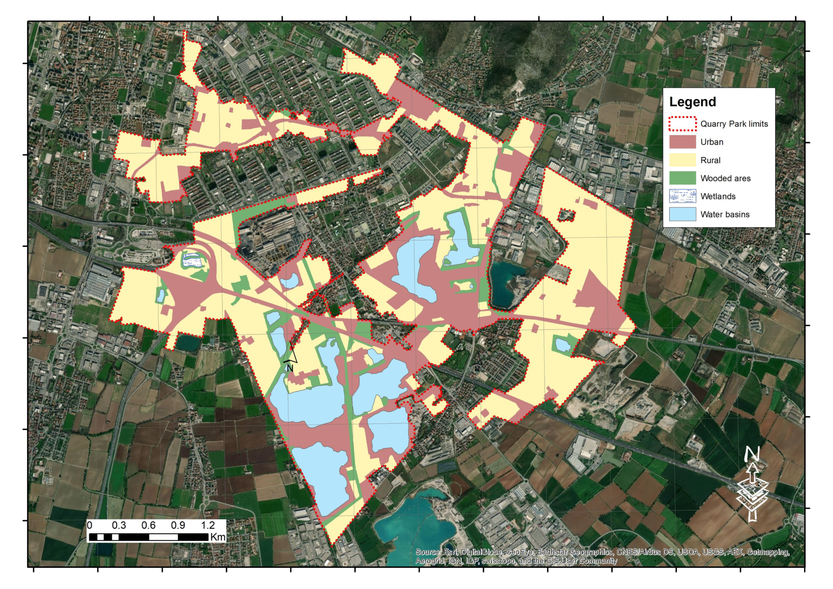
The Quarry Park is located in the suburban spaces in the southeastern part of the city. It covers 960 ha and is projected to become one of the largest European protected urban areas and in particular one of the largest re-naturalized protected urban areas involving some municipalities of the hinterland (Borgosatollo, Castenedolo, Rezzato) that have the same characteristic quarry lakes. Until a few years ago the area was characterized by the exploitation of gravel mining. Excavation activities ceased for economic reasons: they were near exhaustion and the cost to exploit sand and gravel increased. Some years ago there was also a drop in demand due to the construction crisis. The area comprises different land use types (Figure 1 (data source: http://www.geoportale.regione.lombardia.it/metadati?p_p_id=PublishedMetadata_WAR_geoportalemetadataportlet&p_p_lifecycle=0&p_p_state=maximized&p_p_mode=view&_PublishedMetadata_WAR_geoportalemetadataportlet_view=editPublishedMetadata&_PublishedMetadata_WAR_geoportalemetadataportlet_uuid={18EE7CDC-E51B-4DFB-99F8-3CF416FC3C70}&_PublishedMetadata_WAR_geoportalemetadataportlet_editType=view&_PublishedMetadata_WAR_geoportalemetadataportlet_fromAsset=true&rid=local) (accessed on 6 February 2021)). In particular, the urbanized area is 20.7% of the park and the infrastructure, such as highways, railways, metro lines makes up 7.7%. The rural area (49%) is another important element of the landscape [54]. The wooded areas (9.3%) and the wetlands (0.2%) are not very large but are important for their ecological biodiversity. The water basins (13.1%), with their banks, are another representative feature of the new park and planners are creating pedestrian and bike paths around them.
In the early 2000s the local community grouped into local committees and environmental associations began to use the re-naturalized area by organizing various types of events as well as presenting requests and proposals to the Local Administration. Next to this need for empowerment, issues referred to environmental justice in terms of conflicts of interest regarding both the transformation process and the range of possible new land uses emerged. In particular, the population was well aware of the risk that the area could be transformed into a landfill or be affected by new big urbanization projects. Trying to establish a dialogue with local committees and associations as well as with scientific and naturalistic groups, between 2014 and 2015 the Local Administration promoted the participatory planning process “Signs on the water”. The general aim of the process was to encourage a debate on the redevelopment of the south-eastern area of the city. In the postwar period this territory experienced the most extensive urban sprawl, a great increase in the main infrastructure networks (ring roads, highways, railways) and in production settlements. The specific aim of the process was to focus on the area of former extractive basins of sand and gravel, considering the environmental and landscape recomposition and the restitution to the local community of the area that has been conventionally called “Parco delle Cave” for forty years. Participants helped the Administration to localize and define the perimeter and specific interventions of renaturing and environmental protection. They contributed to identify the vocations of the Park, by asking for a transformation which favors the naturalistic, didactic and recreational activities (also looking at some sports like canoeing, nordic walking, biking and running). The local community also contributed to define the mobility inside the area looking in particular at the pedestrian and cycle path system. The 2016 Land Management Plan of the Brescia Municipality (Piano di Governo del Territorio—PGT) translated the strengths, weaknesses, needs, and demands highlighted by the local community during the participatory project into a strategy. The perimeter and the vocations of the area were also defined. In the same period the Administration began acquiring the quarry lakes and the neighboring agricultural lands. At present the public property owned area is about 114 ha. The Administration also started the environmental requalification works. The protected area was formally instituted in 2018 by the Municipality of Brescia through the Local Park of Supra-municipal Interest of the Buffalora and San Polo Quarries (PLIS of Buffalora and San Polo). The PLIS aims first at promoting the conservation of biodiversity and ecosystems (e.g., through reforestation plans) and protecting agricultural landscapes that have natural, historical and cultural value, also with the support of educational activities. The PLIS also takes into account degradation and pollution problems, by trying to transform these issues into potentials for the local development. In particular, the presence of the lakes created by excavation activities represents the most important element that valorizes this urban landscape, as defined in Section 4 [5,55,56,57]. The long-term goal of the PLIS is to transform this “open and permeable” area into “a real oasis” for fauna and flora as well as for people.
2.2. The Urban Political Ecology of Cultural Ecosystem Services
Ecosystem Services (ES) are benefits obtained from ecosystems [58]. The Millennium Ecosystem Assessment (MEA) [58] describes four categories of ecosystem functions, further detailed in four ecosystem services: supporting, provisioning, regulating and cultural services. Supporting services consist of the regulation of basic ecological functions and processes that are necessary for the provision of all other ecosystem services, e.g., production of oxygen, photosynthesis, nutrient cycling, capture of solar energy, decomposition and recycling of organic waste. It is difficult to demonstrate their relationship to human needs because it is mainly indirect and complex. Provisioning services are the products people obtain from ecosystems, e.g., food, fresh water, provision of biotic materials or fuel, so they are widely recognized as essential for meeting human needs. Regulating services are the benefits obtained from the regulation of natural processes, e.g., regulation of the composition of the atmosphere, climate regulation, regulation of the water cycle, water purification, air quality maintenance, crop pollination, biological control of disease and pests, land stabilization and control of soil erosion. Their relationship to human needs is complex to understand but they have been brought to public attention by looking at climate change and natural disasters. Services of the first three categories provide material benefits. On the other hand, Cultural Ecosystem Services are mainly non material benefits arising from human–ecosystem relationships in terms of “cultural diversity, spiritual and religious values, knowledge systems, educational values, inspiration, aesthetic values, social relations, sense of place, cultural heritage values, recreation and ecotourism” [58]. It clearly appears that life-enriching contributions to human well-being from most cultural services are directly experienced and intuitively appreciated. A key point is that the recognition of cultural services strongly depends on the perceptions and expectations of the different stakeholders. So, they cannot be considered as a priori products of nature that people use for a particular benefit to their well-being but rather as relational processes that people actively create, express and also transform through interactions with ecosystems [59].
Following a political ecology framework, Kull et al. [60] presented a critical analysis where they investigated: the origin of the ecosystem services idea, how it works, how it is used and misused, also considering environmental planning and policies. They analyzed the impacts of the ES concept for different parts of society and different components of the environment looking at winners and losers in terms of environmental management, the power structures and discursive frameworks that facilitate such outcomes. Further analyzing the critical issues, they argued that “a variety of scholars critique the ES concept from both internal and external perspectives” [60] (p. 123). From an ecological perspective, the concept is criticized for obscuring ecological functions [61] or leading to unjustified simplifications [62,63]. From a strategic perspective, some see the concept as too broad, and easily confused with others [64], “while others critique its political efficacy” [60] (p. 123), [65]. Looking at the UPE, there are particularly interesting studies that criticize how the concept allows us to avoid considering relevant social, political and context-specific elements [66,67,68] and it reflects and promotes certain market-based models of society. For instance, Gomez-Baggethum et al. [69] argue that even if the concept in itself shows a number of benefits, “its reinforcement of a neoclassical economic model reproduces the market logic and its underlying ideology” [60] (p. 123). In fact, critical scholars insert ES among the tools used by neoliberal approaches to the environment “that commodify nature and create new sites for capital accumulation largely in the hands of a global elite” [60] (p. 123), [70,71,72,73].
The research approach adopted in this paper used the UPE and looked at a particular category of ES, namely the cultural one, and analyzed the social and power factors related to re-naturing the city. Taking into account the critiques to ES, the participatory methodology used did not quantify CES in monetary terms and did not have the aim of promoting an eco-management of the area, but it investigated the socioecological relationships that changed the area. The participatory process analyzed the places characterized by the presence of CES, involving the local community and studying interrelations and conflicts between nature and society. The mapped places identified through the participatory mapping of CES revealed the perception of the local community and placemaking processes. The use of CES aimed at studying more sustainable solutions in environmental planning based on the knowledge and empowerment of local communities [53].
2.3. Cultural Ecosystem Services through a Participatory Mapping Process
Before creating the participatory mapping process of CES, the power relations and conflicts regarding the Park were investigated for ten years through participant observation. This methodology was based on the direct involvement of researchers [74] who actively collaborated with local associations and groups by creating projects and initiatives to promote sustainability in the city of Brescia. Through these activities the complex top-down and bottom-up relationships among the Local Municipality, associations and stakeholders have emerged as fundamental elements in the process of the institution of the Park.
The academic literature recognizes two antithetical ways to enhance participation and citizen empowerment. The first approach based on consensus and top-down processes [75,76,77] requires adoption of a procedure which is close to that of institutions and involves a search for consensus on choices that are controlled from above. The second type of empowerment is a radical bottom-up approach which involves balancing differing visions based on dissent [77,78] as a form of democratic change. An integration of the two approaches allows the active involvement of the community in the co-creation of planning knowledge that improves its political empowerment. According to UPE, civic participation can help create a discussion about citizen needs related to urban environmental governance and can identify a number of strategies for a more equitable distribution of social power and more inclusive models of urban environmental policy [20,21,28,79,80]. Looking at the transformation process of these areas formerly characterized by mining activities into protected re-naturalized areas, both top-down and bottom-up approaches are represented. In the different steps one method can prevail over the other or coexist. UPE helped comprehend these steps by revealing the strategies that underly the creation process of the Park adopted by stakeholders who produced a number of conflicts with consequences in terms of environmental justice.
Starting from these premises, the research group developed a CES participatory mapping process.
A useful approach to study CES in urban areas is based on mapping their presence [81,82] through the perception of the local community. In particular, participatory mapping processes, with the help of GIS (Geographic Information System) solutions, ask participants for the CES location, characteristics and perceptions. Another approach studies CES as attributes of urban parks or urban green areas, inside a city [83,84] or in different cities adopting a comparative viewpoint [85,86]. Looking at this second perspective, CES are considered in terms of features and functions of spaces emerging from the evaluation of users who spend time in different activities.
Our research project mapped the places where the local community assigned the presence of some CES, giving them a cultural value [87] using both approaches. Mapping the places that provide CES helps reconstruct the changes of the socio–natural relationships and the evolution of the socio–ecological value of the area. Our main goal was to give particular attention to the interaction with the community considering the needs and the expectations about the future development of the area. This could provide useful support in the first phases of the planning process. The participatory mapping of CES, looking at a qualitative approach from the beginning of the planning, is one of the elements which gave added value to our approach and distinguished it. The continuation of our study could be dedicated to analyzing its usefulness in greater terms also with regard to touristic functions and the perceptions of majority of users.
Considering participatory methods, the first step focused on the use of the Participatory action research (PAR) methodology [88,89]. This approach looks both at the quality of information generated and at the ways in which skills, knowledge and participants’ capacities are developed through the research experience [53,90,91]. This means looking at the transformation processes investigated in this paper, reflecting with the local community on the evolution of the landscape in the area from a personal and systemic-relational perspective, considering a range of alternative ways of thinking and acting to valorize the area. Thus, it is important to include different tools such as surveys, interviews, focus groups and laboratories in the participatory process [74,92]. This methodology provides an opportunity to make contact with people without limiting the dialogue only to the institutionalized groups. In this way it is possible to paint a more realistic picture of the reasons why the local community recognizes a cultural value in these kinds of re-naturalized areas. Moreover, strategies and tools to develop the environmental policy needed to protect and valorize the area can be proposed.
The next step consisted of linking PAR to a mapping process. This allows translation of acquired information and results of the participatory process on a digital map that can be shared with stakeholders, citizens and experts [93,94,95,96,97,98,99,100]. In fact, with participatory methods the map is conceived as a process which promotes a mutual exchange of information, opinions and knowledge among participants. On the one hand, for experts this means dealing with the local knowledge of the landscape for better planning and, on the other hand, for the local community it means promoting awareness of the cultural elements of the local landscape by strengthening social identity and community empowerment through active participation. Furthermore, producing a participatory map not only means drawing and shaping the results on it but also building a process that is part of this map by understanding how individuals or groups view the world [101]. Considering maps and looking at their performative qualities, one’s attention shifts from what maps represent to the process of map-making and explorations of how “a map becomes part of a story, to be created and enacted, rather than simply serving as a discourse for the powerful” [102] (p. 345). So, as McLain et al. [53] state, maps are tools that can be profitably used for identifying and representing human–environmental connections that have a spatial component and are often difficult to discern using non-spatial analytical techniques. As a result, when considering mapping as a social and political practice and not just a technical one [103,104], there are relevant consequences also in terms of integration between top-down and bottom-up participatory approaches. What is included or excluded on a map represents the values and beliefs of a community [105]. It has the power to affect who controls the use of the space [106], who has access to environmental resources [105] and whose values and interests influence decision making processes on natural resources [107]. If more powerful members seek to dominate the mapping process, one has to note that mapping processes are collaborative, adhere to internal and external power dynamics and minimize opportunities for powerful individuals, groups or communities to dominate mapping [108], altering power dynamics [103] between institutions and communities and within communities [53].
3. Involving the Community in the CES Participatory Mapping Process
Between early 2018 and early 2020 a new participatory process was developed. This was a bottom-up and interdisciplinary participatory project. “Parco delle Cave. Un cuore blu in città—Quarry Park. A blue heart in the city” was led by the local social cooperative Cauto and involved a number of partners: institutional partners like the Local Municipality, the University of Brescia, many schools, and the local community together with environmental and sports associations. It aimed first at increasing public awareness about the environmental and cultural values of the area through an active involvement of the local community. It also aimed at promoting a participatory management through the co-production of activities among the stakeholders involved.
In this participatory planning process our fieldwork lasted from April 2019 to February 2020, involving the local community and enhancing the co-creation of the local knowledge [53]. At the beginning of 2019 we wrote the questionnaires; the data collection and the validation process with the community lasted from May to December and in early 2020 we completed the work by examining the content and results of the interviews, focus groups and labs and processed the information and data. A very intense, time consuming approach was chosen to make contact with the local community, to promote an active involvement and to unveil the local knowledge. We proposed three steps.
The first step consisted of face-to-face interviews with the local historians about the beginning of the mining activity in the 1950s and the transformations of the landscape from rural to industrial and to post-industrial. Following Claval [109], landscapes can be read like a history book: by investigating how re-naturalized areas have been socially produced and re-produced through a variety of socio–ecological processes allows the creation of a picture of the evolution that has taken place in the area in the last few decades.
In the second step it was fundamental to involve local associations, groups and schools in some focus groups and laboratories of CES mapping to test the survey and co-produce a first open map about the places where people recognize cultural values. A close connection emerged between technical and participatory aspects that contributed to improve the potentials of the bottom-up perspective adopted by our research group. Among other things, there was the need to have a sample that could be considered large enough to ensure an adequate contribution of the different voices. So, stakeholders and all the other local environmental and sports groups who were involved participated in the project “Quarry Park. A Blue heart in the city”. Moreover, the use of a printed version, asking participants to mark locations on paper maps, aerial photos, or satellite images, allowed all the participants to reach a high level of involvement therefore avoiding problems related to a respondent’s ability to work with spatial attributes. Another interesting aspect that emerged during our fieldwork was offering the participants open questions, where they could identify problems and suggest solutions. So, we created a first opportunity to actively involve them in the planning process. We organized five focus groups, one in each neighborhood (San Polo Case, San Polo Cimabue, San Polo Parco, San Polino, Bettole-Buffalora), with the local groups and associations and the representatives of the neighborhood councils.
Looking at the topics, we investigated the value given to the places, characteristics, accessibility, CES use patterns (such as frequency of the visits, activities carried out) and attitudes towards the CES provision. Moreover, we dedicated a deep analysis to the perception of the CES in terms of improvement in well-being. We followed the framework proposed by Fish, Church and Winter [59] on the identification of places in which a community that takes part in certain practices can receive benefits, mainly intangible, in terms of cultural experience provided by CES. Therefore, people were asked to describe their interaction with these places and the cultural services they provide by considering the dimensions of well-being that are associated with cultural spaces and practices, into identities they help frame (e.g., belonging, sense of place, rootedness, spirituality, etc.), experiences they help enable (e.g., tranquility, inspiration, escape, discovery, etc.), capabilities they help equip (knowledge, health, judgement, etc.).
After a brief introduction of the interviewers about the meaning of CES and goals of this participatory mapping process, people were asked some open questions:
- -
- Which place do you want to indicate? Please briefly report anything that comes to mind (e.g., parks, gardens, reeds, fields, agricultural landscapes, streams, rivers, inhabited areas, old buildings, churches, etc.)
- -
- Can you localize it on this paper map?
- -
- Can you describe its characteristics?
- -
- How many times do you go to that place per month?
- -
- Is it accessible to everyone?
- -
- How many people do you meet?
- -
- What can be done in that place? What do you usually do in that place? What do people who frequent it do? (e.g., play or exercise, create or express yourself, producing something or taking care of something, collecting or consuming products)
- -
- What does that place offer, what kind of product or service does it produce? (looking at e.g., tourism, excursions, festivals or events, local food or drinks)
- -
- What benefits does that place give you, as an individual user and the community in terms of identity (e.g., belonging, sense of place, rootedness, spirituality, etc.), experiences (e.g., tranquility, inspiration, escape, discovery, etc.), capabilities (knowledge, health, judgement, etc.)?
The third step consisted of the involvement (with the help of local groups and associations, schools and Neighborhood Councils) of the local community in some public labs of CES mapping to complete the map and discuss different governance methods for the park. In the first meeting, after an introduction about the meaning of CES and the goals of this process, people were divided into a number of groups and were asked the same questions proposed in the previous step. Then, respondents were inspired to discuss the cultural and ecological value of the places chosen, the presence of different kinds of landscapes they create, and their evolution.
After that, we combined the information collected to enrich the first open map. Then, we organized other meetings in the form of focus groups and workshops with the local community to discuss the results, that revealed the placemaking processes and the transformations of the urban metabolism. In doing so, the co-creation of knowledge and the community empowerment were stimulated from the bottom involving all the local groups and the active citizenship as a whole. The results obtained represent the starting point of discussion for planning and management strategies and activities based on community involvement.
4. Results
The local community living near the Brescia Quarry Park has fought for many years to obtain the institution of a protected re-naturalized area and to avoid new exploitation forms like landfills. In this placemaking process the local community implicitly recognized the importance of the area from an ecological point of view because of the ecosystem services it provides, like food, water and other products, provisioning, temperature regulating (to contrast the urban heat island effect), air cleaning and biodiversity enhancing. The local community also recognized a number of Cultural Ecosystem Services with regard to the value of the human–ecosystem relationships characterizing the area [59], that are part of the processes that during the years have formed the complex landscape of the re-naturalized area. In particular, these interactions that combine natural, historical and cultural values, generate an individual and societal identity which provides experiences shared across generations [110]. According to the definition of the European Landscape Convention [111] landscapes are areas “as perceived by people, whose character is the result of the action and interaction of natural and/or human factors”. Moreover, by following the social approach to nature [112,113,114], the research process investigated the evolution of the landscape in terms of a co-produced outcome of the interactions between social and natural systems [57,115,116]. Our research aimed at introducing, in planning and management processes, the socio–ecological relationships between tangible characteristics, such as biophysical features and physical artifacts, and intangible attributes given by the community. These relationships that are inherited from past generations, have to be maintained in the present and improved for future generations.
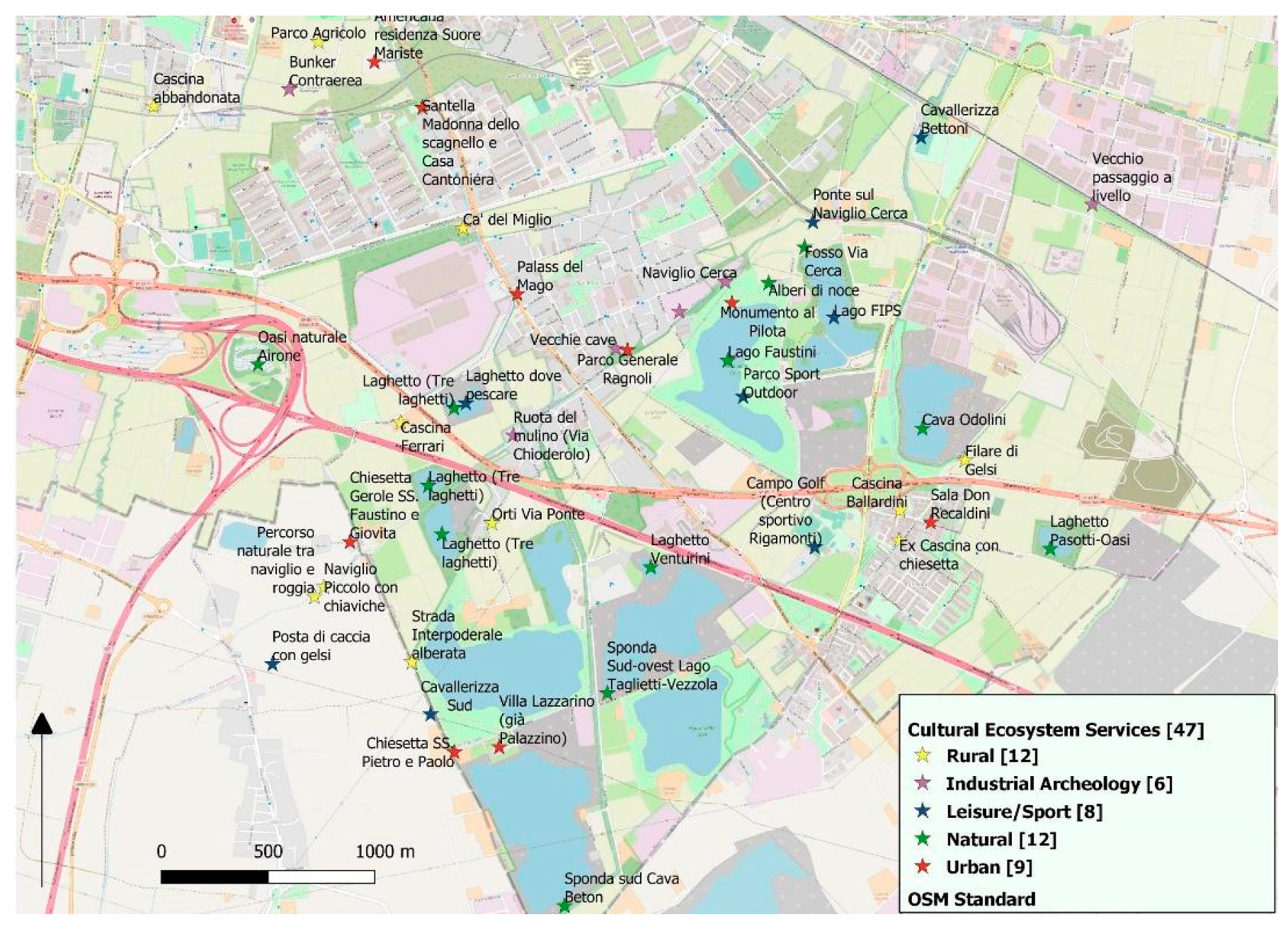
The points indicated in Figure 2 represent the places with a cultural value recognized by the community. The data and information collected in the mapping process showed the complexity of the urban nature that is stratified into different types of landscape. The artefacts containing memories and narratives important for local people [117], the socio–ecological relationships, the use patterns and benefits, shaped the mapped places. For every place indicated, we created a form containing the perceptions of the participants in terms of CES, on which we built an open map (Figure 2). Then, we categorized these places looking at what people do and what kind of benefits and/or products they obtain. This was possible through a preliminary qualitative analysis of the answers identifying some key concepts related to certain features: rural, urban, industrial, natural or linked to leisure.
The 47 places with CES identified and analyzed in the answers of the participants are categorized as follows:
- Rural landscape (12 points/places): crops, streams, trees along the streams, “cascine” —old buildings typical of the Lombard agricultural landscape (CES: production, sense of place, excursions).
- Urban landscape (nine points/places): green paths and gardens, ancient historical buildings, churches (CES: environmental education/knowledge, spirituality, sense of place).
- Leisure landscape (eight points/places): the re-generated places around the quarry lakes (CES: outdoor activities, sports, excursions).
- Natural landscape (12 points/places): lakes and wetlands and the associated biodiversity in terms of flora and fauna (CES: ecological knowledge, education, inspiration).
- Industrial landscape (six points/places): signs of excavation or other industrial activities such as a spinning mill or a water mill, with a value in terms of industrial archeology (CES: sense of place, knowledge, education).
This preliminary analysis of CES based on the answers of the local community and on its knowledge of the area, allowed us to identify specific landscape features that local stakeholders recognize as having a particular socio–ecological value answering the research question of the paper. The results are based on the interpretation of the responses received during the mapping process and on the discussion and evaluation done during the focus groups and workshops. Revealing the complexity of the area these results represent an important step forward compared to the PGT approved in 2016 in which the Local Administration established the Park recognizing the ecological values of the area. The local community placed the cultural and ecological relationships in the mapped CES. In this way, it suggested some places as elements of the different landscapes characterizing the Park. Assigning different uses and values, the places emerged in the mapping process also revealed the conflicts inside the area and suggested the need to examine unequal power relations through the UPE. Using only CES or only UPE could return a partial result, losing the contribution of the local ecological knowledge or undervaluing the power relations and conflicts. Taking into account how placemaking has transformed the characteristics, and also considering unequal power relations, conflicts and strategies inside the area, it can be very useful to co-produce environmental planning based on a socio–cultural approach. The presence of a broad range of CES, and as a consequence of different types of socio–ecological landscapes, could suggest different planning strategies starting from a strong attention to the biodiversity and protection of nature to the possibility of excursions and tourism activities.
Looking at future perspectives, there is a need for an in-depth study of the distribution of CES, integrating this qualitative analysis with quantitative methodologies, e.g., quantifying the surface of the different landscapes, looking at the relationships between CES and land use types, CES and visitors to the Park, CES and biodiversity, CES and environmental justice, etc. In terms of planning this participatory approach could contribute to the valorization of typical rural landscapes in the suburban area, the preservation of the rural and natural characteristics and the implementation of ecological networks.
5. Discussion
The UPE approach allowed us to understand how this exploited and degraded land became a relevant natural area from the local community’s point of view. In particular, the participatory mapping helped investigate the placemaking of the area by connecting physical, social and semiotic dimensions in the re-naturalization process. It helped analyze the new features as specific historical results of this process and therefore contributed to an increase in public awareness on the need to protect urban nature transformed by human–nature interactions. As Pagani [118] states, the future of these areas is mainly based on culturally verified transformation processes, whereby the awareness of their roots and the relationship between past and present can have important perspectives. The “old” signs of human–nature interaction, e.g., old buildings typical of the agricultural landscape, ancient historical buildings, typical crops, etc., full of meaning that until some decades ago were attentive to a dialogue with nature have to be recovered, valorized and reinserted as cornerstones of the local landscape. At the same time also “new” signs of human–nature interaction such as the quarry lakes created by excavation activities, together with the new grown flora and fauna, have to be inserted as key aspects of the landscape. Achieving these goals is hard due to the complexity of the re-naturalized area. Placemaking was investigated with particular attention to conflicts and changes that characterize the re-naturalization of the area and it shows a number of factors that refer to the urban metabolism which make it difficult to intervene: public and private properties, high demographic density, intensive agriculture, high concentration of industrial plants in particular manufacturing, high road infrastructure density, progressive loss of public space, increased overall ecological stress, etc. By using the participatory approach, the causes of this complexity looked clear. All the stakeholders involved, historians, local associations as well as some citizens, highlighted the divergences in the attribution of meaning and value of the area by local groups representing strong conflicts of interest [119] (p. 27). These conflicts of interest are well represented in the town planning and territorial government plans and in their revisions that have occurred over time for the enhancement of the neighboring road infrastructures and for the transformation of some internal as well as contiguous areas to the re-naturalized area into new structures e.g., residential, tertiary and industrial zones. Therefore, one of the main issues is that in the last decades economic interests have prevailed over the interests referred to the socio–ecological protection and valorization of the area. It demonstrates that the urban metabolism and more general questions of socio–environmental sustainability are fundamentally political questions with a number of winners (the economic sectors referred to the exploitation of resources) and losers (the citizens who suffered this exploitation) from the processes of metabolic change characterizing the area.
Results of the participatory approach for mapping the local community perceptions of Cultural Ecosystem Services in the UPE framework also provided a number of interesting insights for adopting active policies to valorize the re-naturalized area insisting on the need to pursue an innovative perspective. First of all, this area should no longer be considered as a constraint but as an opportunity for local development. Moreover, the area can play a strategic role in terms of socio–natural well-being improvement e.g., biodiversity, education, cultural and ecological knowledge, sense of place, recreation, tourism, etc. In particular, what emerges from the approach adopted is that local stakeholders first have to recognize the endogenous potentials of the area that cannot be reproduced elsewhere. Then, they also have to contribute to identifying lasting dynamic balances between humans and ecosystems [28,29] looking at multidimensional and multiscalar relationships, between the environmental and social and economic components.
Starting from the results of the local knowledge analysis, in order to recognize the socio–ecological value of the area and to examine the society–nature relationships in a multidimensional and multiscalar perspective the need emerges to simultaneously develop four lines of action in sustainable environmental planning:
- To recognize, protect and valorize the natural and cultural elements as well as the results of the transformation and re-transformation of city–nature relationships which co-determine each other [28] (pp. 11–12) and characterize the metabolism of the re-naturalized area. In line with Bieling et al. [120] (p. 28), our study reveals that “practices, activities, and experiences are closely related to perceived linkages between landscapes and well-being”. Re-naturing the city and in particular re-naturalizing this former industrial area produces benefits in terms of identities, experiences and capabilities.
- To consider the uneven power relations and the impact of the conflicts and strategies adopted by the local community and stakeholders. The renaturing process of the quarries began at the end of their exploitation and most quarry owners did not participate actively in the renaturalization. Therefore, the Local Municipality directly intervened in the transformation of these areas, which returned to being publicly owned, and in the monitoring of environmental conditions of soils and water lakes. Comparing this case study with the brownfield regeneration in Europe [42], it emerges that in our case the local community is the main actor in producing the socio–ecological transformation. The public intervention of the Local Administration characterized the following step and was based on the socio–ecological value of the area perceived by the local community. Now, citizens as well as local stakeholders such as farmers have to play a real role in achieving socio–ecological “sustainability” through a democratically controlled and organized process that identifies the strategies through which a more equitable distribution of social power and a reduction in impacts can be reached.
- To take into account the so-called “local networks” between what is inside and what is in the immediate vicinity. Sustainability is not to be found exclusively within the perimeter, but at the territory level as a whole. The logic behind the protection and valorization of the re-naturalized area is closely connected with the higher anthropogenic pressures implemented beyond the area’s borders [121] (pp. 127–128). The creation of a connective tissue of this green infrastructure [122] with the adjoining areas is therefore a good strategy to guarantee the survival and effectiveness of the protected area itself in terms of sustainability [123] (p. 13) and to maintain the capacity for self-reproduction of the entire territory.
- To take into account the so-called “global networks of ecosystems”: ecosystems exchange energy and material through a network of worldwide relationships [124,125]. In fact, the relationships analyzed link distant places and ecosystems together and allow us to relate local processes with wider socio–metabolic flows, networks, configurations, and dynamics. As Daniel et al. [110] underline, the ES framework allows to consider the full array of contributions that ecosystems provide for human well-being and it also allows recognition of the interconnectedness of ecosystems across the broad spatial scales over which ecosystems and humans interact. As Bieling et al. [120] state, even if CES are more spatially aggregated than other services, they also include synergies on a broader scale. In fact, when asked about linkages of mapped places to well-being, respondents frequently mentioned biophysical landscape features, that represent the basis of CES. As a consequence, the planning and management processes of this re-naturalized area have to take the ecosystem service categories into account as a whole.
These four lines of action can contribute to creating one of the largest European re-naturalized protected areas in such a complex medium-sized urban system. They also respond to the need of creating a broad ecological network.
6. Conclusions
“...In sum, the political-ecological examination of the urbanization process reveals the inherently contradictory nature of the process of metabolic circulatory change and teases out the inevitable conflicts (or the displacements thereof) that infuse socio-environmental change [...] The political programme, then, of political ecology is to enhance the democratic content of socio-environmental construction by means of identifying the strategies through which a more equitable distribution of social power and a more inclusive mode of the production of nature can be achieved” [28] (pp. 11–12)
The research project presented in the paper followed these suggestions to analyze the urban metabolism and the strategies and power relations characterizing the process of renaturalization. The participatory mapping of the local community’s perceptions of CES allowed us to understand the socio–ecological transformations of the last decades that have increased the complexity of the landscape. Our study captured changes in terms of pressures exerted and in terms of social relationships that underlie this particular socio–ecological system: until a few years ago the interests expressed by the excavation activities had prevailed and now the local community is reappropriating the area. However, many problems expressed by uneven power relations persist and as a result there are inevitable conflicts of interest. Moreover, the research helped us understand changes in the attribution of the socio–natural value which reflects how an exploited and degraded area can become a relevant place from the local community’s point of view. The community, which is struggling for the recognition of the value in ecological and cultural terms, plays a central role in the reshaping process. Now the perception has completely changed, and the protected area is fundamental for the human–nature well-being of the city and its surroundings. This suggests a profound change in planning and management, taking into account the relational terms on which values, and the benefits that people gain, are constructed.
To promote combining the CES mapping and UPE approach, we are now proposing the results of our research to the PLIS committees that manage the protected area. The participatory mapping process did not directly influence the decision of the Local Administration about the composition of these committees but showed the relevance of local knowledge and need of empowerment. The Management Committee is composed of the Director, the Councilor for the Environment of the Municipality, two representatives of the associations, one of the neighborhood councils and one of private donors. The environmental associations chose one researcher of our group as their representative in this committee. The Scientific Committee is composed of two members chosen by the Administration, two selected by the Management Committee and the coordinator who is a member of the Natural Science Museum of Brescia. These organisms have been defined throughout a top-down approach, but with the aim to promote an active involvement of all the local stakeholders from the bottom. So, powerful groups, institutionalized groups, decision makers, experts as well as associations, active minorities and the general public can have a say in the whole process, from recognizing the cultural–natural value of places to suggesting and implementing environmental strategies and tools. The integration between top-down and bottom-up approaches contributes to ensure adequate planning and management that is able to guarantee, in the long run, the respect and valorization of the peculiarities of the area, a more equitable distribution of social power as well as the consideration of the local and global networks. It also enables decision-makers to promote an effective connection between the needs of the community and the goals of environmental governance.
Author Contributions
Conceptualization, A.P., and M.T.; methodology, M.T. and A.P.; software, M.T.; validation, M.T.; formal analysis, M.T.; investigation, M.T. and A.P.; resources, M.T. and A.P.; data curation, M.T.; writing—original draft preparation, A.P.: Section 2.2, Section 2.3, Section 3, Section 5 and M.T.: Section 1, Section 2, Section 2.1, Section 4, Section 6; writing—review and editing, A.P.: Section 2.2, Section 2.3, Section 3, Section 5 and M.T.: Section 1, Section 2, Section 2.1, Section 4, Section 6; visualization, M.T. and A.P.; supervision, A.P.; project administration, A.P.; funding acquisition, A.P. All authors have read and agreed to the published version of the manuscript.
Funding
This research was partially funded by the scientific research project “Parco delle Cave. Un cuore blu in città—Quarry Park. A blue heart in the city” funded by the Cariplo Foundation.
Institutional Review Board Statement
Not applicable.
Informed Consent Statement
Informed consent was obtained from all subjects involved in the study.
Acknowledgments
We are grateful to the local community, the environmental and local associations, the Natural Science Museum of Brescia and the Management Committee of the Park for their crucial contribution in the various steps of our analysis.
Conflicts of Interest
The authors declare no conflict of interest. The funders had no role in the design of the study; in the collection, analyses, or interpretation of data; in the writing of the manuscript, or in the decision to publish the results.
References
- European Commission. Living Well, within the Limits of Our Planet: General Union Environment Action Programme to 2020; Europäische Kommission, Ed.; Publication Office of the European Union: Luxembourg, 2014; ISBN 978-92-79-34724-5. [Google Scholar]
- Liberman, P.B. (Re)Greening the City: Urban Park Restoration as a Spatial Fix. Geogr. Compass 2010, 4, 1392–1407. [Google Scholar] [CrossRef]
- Xu, Z.; Gao, X.; Wang, Z.; Fan, J. Big Data-Based Evaluation of Urban Parks: A Chinese Case Study. Sustainability 2019, 11, 2125. [Google Scholar] [CrossRef] [Green Version]
- Xie, Q.; Yue, Y.; Sun, Q.; Chen, S.; Lee, S.-B.; Kim, S.W. Assessment of Ecosystem Service Values of Urban Parks in Improving Air Quality: A Case Study of Wuhan, China. Sustainability 2019, 11, 6519. [Google Scholar] [CrossRef] [Green Version]
- Olwig, K.R. Landscape. In International Encyclopedia of the Social & Behavioral Sciences; Elsevier: Amsterdam, The Netherlands, 2015; pp. 224–230. ISBN 978-0-08-097087-5. [Google Scholar]
- Antrop, M. Landscape Change and the Urbanization Process in Europe. Landsc. Urban Plan. 2004, 67, 9–26. [Google Scholar] [CrossRef]
- Scott, M.; Lennon, M.; Haase, D.; Kazmierczak, A.; Clabby, G.; Beatley, T. Nature-Based Solutions for the Contemporary City/Re-Naturing the City/Reflections on Urban Landscapes, Ecosystems Services and Nature-Based Solutions in Cities/Multifunctional Green Infrastructure and Climate Change Adaptation: Brownfield Greening as an Adaptation Strategy for Vulnerable Communities?/Delivering Green Infrastructure through Planning: Insights from Practice in Fingal, Ireland/Planning for Biophilic Cities: From Theory to Practice. Plan. Theory Pract. 2016, 17, 267–300. [Google Scholar] [CrossRef] [Green Version]
- Beatley, T. Green Cities of Europe; Island Press/Center for Resource Economics: Washington, DC, USA, 2012; ISBN 978-1-59726-220-0. [Google Scholar]
- Beatley, T. Biophilic Cities: Integrating Nature into Urban Design and Planning; EBSCO Ebook Academic Collection; Island Press: Washington, DC, USA, 2010; ISBN 978-1-59726-986-5. [Google Scholar]
- Wheeler, S.M. Planning for Sustainability: Creating Livable, Equitable and Ecological Communities; Taylor & Francis: London, UK; New York, NY, USA, 2004; ISBN 978-1-134-35171-8. [Google Scholar]
- Wheeler, S.M.; Beatley, T. The Sustainable Urban Development Reader; Routledge urban reader series; Routledge: London, UK; New York, NY, USA, 2004; ISBN 978-0-415-31187-8. [Google Scholar]
- Howard, E. Garden Cities of To-Morrow: (Being the Second Edition of “To-Morrow: A Peaceful Path to Real Reform”); Garden City Association; S. Sonnenschein & Company, Limited: London, UK, 1902. [Google Scholar]
- Corbusier, L. The City of To-Morrow and Its Planning; J. Rodker: London, UK, 1929. [Google Scholar]
- Register, R. Ecocities: Building Cities in Balance with Nature; Berkeley Hills Books: Berkeley, CA, USA, 2002; ISBN 978-1-893163-37-9. [Google Scholar]
- Tsolakis, N.; Anthopoulos, L. Eco-Cities: An Integrated System Dynamics Framework and a Concise Research Taxonomy. Sustain. Cities Soc. 2015, 17, 1–14. [Google Scholar] [CrossRef]
- Antrobus, D. Smart Green Cities: From Modernization to Resilience? Urban Res. Pract. 2011, 4, 207–214. [Google Scholar] [CrossRef]
- Premalatha, M.; Tauseef, S.M.; Abbasi, T.; Abbasi, S.A. The Promise and the Performance of the World’s First Two Zero Carbon Eco-Cities. Renew. Sustain. Energy Rev. 2013, 25, 660–669. [Google Scholar] [CrossRef]
- Rapoport, E. Utopian Visions and Real Estate Dreams: The Eco-City Past, Present and Future: Utopian Visions and Real Estate Dreams. Geogr. Compass 2014, 8, 137–149. [Google Scholar] [CrossRef] [Green Version]
- Tomozeiu, D.; Joss, S.; Cowley, R. Eco-Cities—A Global Survey 2011: Eco-City Profiles; University of Westminster: London, UK, 2011; ISBN 978-0-9570527-0-3. [Google Scholar]
- Tzaninis, Y.; Mandler, T.; Kaika, M.; Keil, R. Moving Urban Political Ecology beyond the ‘Urbanization of Nature’. Prog. Hum. Geogr. 2020. [Google Scholar] [CrossRef] [Green Version]
- Connolly, C. Urban Political Ecology Beyond Methodological Cityism. Int. J. Urban Reg. Res. 2019, 43, 63–75. [Google Scholar] [CrossRef]
- Heynen, N. Urban Political Ecology III: The Feminist and Queer Century. Prog. Hum. Geogr. 2018, 42, 446–452. [Google Scholar] [CrossRef] [Green Version]
- Heynen, N. Urban Political Ecology II: The Abolitionist Century. Prog. Hum. Geogr. 2016, 40, 839–845. [Google Scholar] [CrossRef]
- Heynen, N. Urban Political Ecology I: The Urban Century. Prog. Hum. Geogr. 2014, 38, 598–604. [Google Scholar] [CrossRef]
- Kaika, M.; Swyngedouw, E. The Urbanization of Nature: Great Promises, Impasse, and New Beginnings. In The New Blackwell Companion to the City; Bridge, G., Watson, S., Eds.; Wiley-Blackwell: Oxford, UK, 2012; pp. 96–107. ISBN 978-1-4443-9510-5. [Google Scholar]
- Zimmer, A. Urban Political Ecology. Theoretical Concepts, Challenges, and Suggested Future Directions. Erdkunde 2010, 64, 343–354. [Google Scholar] [CrossRef]
- Swyngedouw, E.; Kaika, M. The Environment of the City… or the Urbanization of Nature. In A Companion to the City; Bridge, G., Watson, S., Eds.; John Wiley & Sons, Ltd.: Hoboken, NJ, USA, 2008; pp. 567–580. ISBN 978-0-470-69341-4. [Google Scholar]
- Heynen, N.; Kaika, M.; Swyngedouw, E. In the Nature of Cities: Urban Political Ecology and the Politics of Urban Metabolism; Taylor & Francis: London, UK; New York, NY, USA, 2006; ISBN 978-1-134-20646-9. [Google Scholar]
- Swyngedouw, E. The City as a Hybrid: On Nature, Society and Cyborg Urbanization. Capital. Nat. Soc. 1996, 7, 65–80. [Google Scholar] [CrossRef]
- Harvey, D. The Nature of Environment: Dialectics of Social and Environmental Change. In Social Register. Real Problems, False Solutions; Miliband, R., Panitch, L., Eds.; Merlin Press: London, UK, 1993; pp. 1–51. [Google Scholar]
- Swyngedouw, E. Circulations and Metabolisms: (Hybrid) Natures and (Cyborg) Cities. Sci. Cult. 2006, 15, 105–121. [Google Scholar] [CrossRef]
- Franz, M.; Güles, O.; Prey, G. Place-Making and “green” Reuses of Brownfields in the Ruhr. Tijdschrift Voor Economische en Sociale Geografie 2008, 99, 316–328. [Google Scholar] [CrossRef]
- Raco, M. Assessing the Discourses and Practices of Urban Regeneration in a Growing Region. Geoforum 2003, 34, 37–55. [Google Scholar] [CrossRef]
- Healey, P. Planning in Relational Space and Time: Responding to New Realities. In A Companion to the City; Bridge, G., Watson, S., Eds.; Blackwell: Hoboken, NJ, USA, 2000; pp. 517–530. [Google Scholar]
- Lefebvre, H. The Production of Space; Blackwell: Hoboken, NJ, USA, 1991; ISBN 978-0-631-18177-4. [Google Scholar]
- Swyngedouw, E. Modernity and Hybridity: Nature, Regeneracionismo, and the Production of the Spanish Waterscape, 1890–1930. Ann. Assoc. Am. Geogr. 1999, 89, 443–465. [Google Scholar] [CrossRef]
- Lin, H.; Zhu, Y.; Ahmad, N.; Han, Q. A Scientometric Analysis and Visualization of Global Research on Brownfields. Environ Sci. Pollut. Res. 2019, 26, 17666–17684. [Google Scholar] [CrossRef] [PubMed]
- Song, Y.; Kirkwood, N.; Maksimović, Č.; Zhen, X.; O’Connor, D.; Jin, Y.; Hou, D. Nature Based Solutions for Contaminated Land Remediation and Brownfield Redevelopment in Cities: A Review. Sci. Total Environ. 2019, 663, 568–579. [Google Scholar] [CrossRef] [PubMed]
- Cortinovis, C.; Geneletti, D. Mapping and Assessing Ecosystem Services to Support Urban Planning: A Case Study on Brownfield Regeneration in Trento, Italy. One Ecosyst. 2018, 3, e25477. [Google Scholar] [CrossRef]
- Hula, R. Reclaiming Brownfields. A Comparative Analysis of Adaptive Reuse of Contaminated Properties; Routledge: Abingdon, UK, 2012; ISBN 978-1-315-60390-2. [Google Scholar]
- Popescu, G.; Pǎtrǎşcoiu, R. Brownfield Sites—Between Abandonment and Redevelopment Case Study: Craiova City. Hum. Geogr. 2012, 6, 91–97. [Google Scholar] [CrossRef] [Green Version]
- Franz, M.; Pahlen, G.; Nathanail, P.; Okuniek, N.; Koj, A. Sustainable Development and Brownfield Regeneration. Environ. Sci. 2006, 3, 135–151. [Google Scholar] [CrossRef] [Green Version]
- Yount, K.R. What Are Brownfields? Finding a Conceptual Definition. Environ. Pract. 2003, 5, 25–33. [Google Scholar] [CrossRef]
- Rink, D.; Arndt, T. Investigating Perception of Green Structure Configuration for Afforestation in Urban Brownfield Development by Visual Methods-A Case Study in Leipzig, Germany. Urban For. Urban Green. 2016, 15, 65–74. [Google Scholar] [CrossRef]
- Harrison, C.; Davies, G. Conserving Biodiversity That Matters: Practitioners’ Perspectives on Brownfield Development and Urban Nature Conservation in London. J. Environ. Manag. 2002, 65, 95–108. [Google Scholar] [CrossRef]
- De Sousa, C. Brownfield Redevelopment versus Greenfield Development: A Private Sector Perspective on the Costs and Risks Associated with Brownfield Redevelopment in the Greater Toronto Area. J. Environ. Plan. Manag. 2000, 43, 831–853. [Google Scholar] [CrossRef]
- EU Regional Policy. EU Regional Policy Workshop on Re-Using Brownfield Sites and Buildings; EU Regional Policy: Luxembourg, 2010; Available online: https://ec.europa.eu/regional_policy/archive/conferences/sustainable-growth/doc/rfec_brownfield_en.pdf (accessed on 20 December 2020).
- Baczyńska, E.; Lorenc, M.W.; Kaźmierczak, U. The Landscape Attractiveness of Abandoned Quarries. Geoheritage 2018, 10, 271–285. [Google Scholar] [CrossRef] [Green Version]
- Vooslo, P. Post-Industrial Urban Quarries as Places of Recreation and the New Wilderness—A South African Perspective. Town Reg. Plan. 2018, 72. [Google Scholar] [CrossRef] [Green Version]
- Dal Sasso, P.; Ottolino, M.A.; Caliandro, L.P. Identification of Quarries Rehabilitation Scenarios: A Case Study Within the Metropolitan Area of Bari (Italy). Environ. Manag. 2012, 49, 1174–1191. [Google Scholar] [CrossRef]
- Lintukangas, M.; Suihkonen, A.; Salomäki, P.; Selonen, O. Post-Mining Solutions for Natural Stone Quarries. J. Min. Sci. 2012, 48, 123–134. [Google Scholar] [CrossRef]
- Damigos, D.; Kaliampakos, D. Assessing the Benefits of Reclaiming Urban Quarries: A CVM Analysis. Landsc. Urban Plan. 2003, 64, 249–258. [Google Scholar] [CrossRef]
- McLain, R.; Poe, M.; Biedenweg, K.; Cerveny, L.; Besser, D.; Blahna, D. Making Sense of Human Ecology Mapping: An Overview of Approaches to Integrating Socio-Spatial Data into Environmental Planning. Hum. Ecol. 2013, 41, 651–665. [Google Scholar] [CrossRef] [Green Version]
- Municipality of Brescia. Relazione Proposta Plis Cave Brescia; Piano di Governo del Territorio: Brescia, Italy, 2016. [Google Scholar]
- Ziyaee, M. Assessment of Urban Identity through a Matrix of Cultural Landscapes. Cities 2018, 74, 21–31. [Google Scholar] [CrossRef]
- Conzen, M.P. Cultural Landscape in Geography. In International Encyclopedia of the Social & Behavioral Sciences; Smelser, N.J., Baltes, P.B., Eds.; Pergamon: Oxford, UK, 2001; pp. 3086–3092. ISBN 978-0-08-043076-8. [Google Scholar]
- Cosgrove, D.E. Social Formation and Symbolic Landscape; Croom Helm historical geography series; Croom Helm: London, UK, 1984; ISBN 978-0-7099-0780-0. [Google Scholar]
- Millennium Ecosystem Assessment. Ecosystems and Human Well-Being: Synthesis; Millennium Ecosystem Assessment (Program), Ed.; Island Press: Washington, DC, USA, 2005; ISBN 978-1-59726-040-4. [Google Scholar]
- Fish, R.; Church, A.; Winter, M. Conceptualising Cultural Ecosystem Services: A Novel Framework for Research and Critical Engagement. Ecosyst. Serv. 2016, 21, 208–217. [Google Scholar] [CrossRef] [Green Version]
- Kull, C.A.; Arnauld de Sartre, X.; Castro-Larrañaga, M. The Political Ecology of Ecosystem Services. Geoforum 2015, 61, 122–134. [Google Scholar] [CrossRef] [Green Version]
- Peterson, M.J.; Hall, D.M.; Feldpausch-Parker, A.M.; Peterson, T.R. Obscuring Ecosystem Function with Application of the Ecosystem Services Concept. Conserv. Biol. 2010, 24, 113–119. [Google Scholar] [CrossRef]
- Norgaard, R.B. Ecosystem Services: From Eye-Opening Metaphor to Complexity Blinder. Ecol. Econ. 2010, 69, 1219–1227. [Google Scholar] [CrossRef]
- Swift, M.J.; Izac, A.-M.N.; Van Noordwijk, M. Biodiversity and Ecosystem Services in Agricultural Landscapes—Are We Asking the Right Questions? Agric. Ecosyst. Environ. 2004, 104, 113–134. [Google Scholar] [CrossRef]
- Lamarque, P.; Quétier, F.; Lavorel, S. The Diversity of the Ecosystem Services Concept and Its Implications for Their Assessment and Management. Comptes Rendus Biol. 2011, 334, 441–449. [Google Scholar] [CrossRef] [PubMed]
- Van Hecken, G.; Bastiaensen, J. Payments for Ecosystem Services: Justified or Not? A Political View. Environ. Sci. Policy 2010, 13, 785–792. [Google Scholar] [CrossRef]
- Corbera, E.; Brown, K.; Adger, N.W. The Equity and Legitimacy of Markets for Ecosystem Services. Dev. Change 2007, 38, 587–613. [Google Scholar] [CrossRef]
- Daw, T.; Brown, K.; Rosendo, S.; Pomeroy, R. Applying the Ecosystem Services Concept to Poverty Alleviation: The Need to Disaggregate Human Well-Being. Environ. Conserv. 2011, 38, 370–379. [Google Scholar] [CrossRef] [Green Version]
- Fairhead, J.; Leach, M.; Scoones, I. Green Grabbing: A New Appropriation of Nature? J. Peasant Stud. 2012, 39, 237–261. [Google Scholar] [CrossRef] [Green Version]
- Gómez-Baggethun, E.; de Groot, R.; Lomas, P.L.; Montes, C. The History of Ecosystem Services in Economic Theory and Practice: From Early Notions to Markets and Payment Schemes. Ecol. Econ. 2010, 69, 1209–1218. [Google Scholar] [CrossRef]
- Heynen, N.; Robbins, P. The Neoliberalization of Nature: Governance, Privatization, Enclosure and Valuation. Capital. Nat. Soc. 2005, 16, 5–8. [Google Scholar] [CrossRef]
- McAfee, K. Nature in the Market-World: Ecosystem Services and Inequality. Development 2012, 55, 25–33. [Google Scholar] [CrossRef]
- Mcafee, K. The Contradictory Logic of Global Ecosystem Services Markets. Dev. Chang. 2012, 43, 105–131. [Google Scholar] [CrossRef]
- McCarthy, J.; Prudham, S. Neoliberal Nature and the Nature of Neoliberalism. Geoforum 2004, 35, 275–283. [Google Scholar] [CrossRef]
- Laurier, E. Participant observation. In Key Methods in Geography; Clifford, N.J., French, S., Valentine, G., Eds.; Sage Publications: Thousand Oaks, CA, USA, 2010; pp. 116–130. ISBN 978-1-4129-3508-1. [Google Scholar]
- Blakeley, G. Governing Ourselves: Citizen Participation and Governance in Barcelona and Manchester. Int. J. Urban Reg. Res. 2010, 34, 130–145. [Google Scholar] [CrossRef]
- Guarneros-Meza, V.; Geddes, M. Local Governance and Participation under Neoliberalism: Comparative Perspectives. Int. J. Urban Reg. Res. 2010, 34, 115–129. [Google Scholar] [CrossRef]
- Silver, H.; Scott, A.; Kazepov, Y. Participation in Urban Contention and Deliberation. Int. J. Urban Reg. Res. 2010, 34, 453–477. [Google Scholar] [CrossRef] [Green Version]
- Swyngedouw, E. The Antinomies of the Postpolitical City: In Search of a Democratic Politics of Environmental Production. Int. J. Urban Reg. Res. 2009, 33, 601–620. [Google Scholar] [CrossRef]
- Tononi, M.; Pietta, A.; Bonati, S. Alternative Spaces of Urban Sustainability: Results of a First Integrative Approach in the Italian City of Brescia. Geogr. J. 2017, 183, 187–200. [Google Scholar] [CrossRef]
- Swyngedouw, E.; Heynen, N.C. Urban Political Ecology, Justice and the Politics of Scale. Antipode 2003, 35, 898–918. [Google Scholar] [CrossRef]
- Canedoli, C.; Bullock, C.; Collier, M.J.; Joyce, D.; Padoa-Schioppa, E. Public Participatory Mapping of Cultural Ecosystem Services: Citizen Perception and Park Management in the Parco Nord of Milan (Italy). Sustainability 2017, 9, 891. [Google Scholar] [CrossRef] [Green Version]
- Rall, E.; Bieling, C.; Zytynska, S.; Haase, D. Exploring City-Wide Patterns of Cultural Ecosystem Service Perceptions and Use. Ecol. Indic. 2017, 77, 80–95. [Google Scholar] [CrossRef]
- Buchel, S.; Frantzeskaki, N. Citizens’ Voice: A Case Study about Perceived Ecosystem Services by Urban Park Users in Rotterdam, The Netherlands. Ecosyst. Serv. 2015, 12, 169–177. [Google Scholar] [CrossRef]
- Langemeyer, J.; Baró, F.; Roebeling, P.; Gómez-Baggethun, E. Contrasting Values of Cultural Ecosystem Services in Urban Areas: The Case of Park Montjuïc in Barcelona. Ecosyst. Serv. 2015, 12, 178–186. [Google Scholar] [CrossRef]
- Zwierzchowska, I.; Hof, A.; Iojă, I.C.; Mueller, C.; Poniży, L.; Breuste, J.; Mizgajski, A. Multi-Scale Assessment of Cultural Ecosystem Services of Parks in Central European Cities. Urban For. Urban Green. 2018, 30, 84–97. [Google Scholar] [CrossRef]
- Bertram, C.; Rehdanz, K. Preferences for Cultural Urban Ecosystem Services: Comparing Attitudes, Perception, and Use. Ecosyst. Serv. 2015, 12, 187–199. [Google Scholar] [CrossRef]
- Tononi, M.; Pietta, A. Moving through the quarries park. The case of Brescia. In Pedestrians, Urban Spaces and Health, Proceedings of the XXIV International Conference on Living and Walking in Cities, Brescia, Italy, 12–13 September 2019; Tira, M., Pezzagno, M., Richiedei, A., Eds.; CRC Press: Boca Raton, FL, USA, 2020; pp. 186–190. ISBN 978-1-00-302737-9. [Google Scholar]
- Kindon, S.L.; Pain, R.; Kesby, M. Participatory Action Research Approaches and Methods: Connecting People, Participation and Place; Routledge: Abingdon, UK, 2007; ISBN 978-0-415-40550-8. [Google Scholar]
- Breitbart, M.M. Participatory research methods. In Key Methods in Geography; Clifford, N.J., French, S., Valentine, G., Eds.; Sage Publications: Thousand Oaks, CA, USA, 2010; pp. 141–156. ISBN 978-1-4129-3508-1. [Google Scholar]
- Cornwall, A.; Jewkes, R. What Is Participatory Research? Soc. Sci. Med. 2010, 1667–1676. [Google Scholar] [CrossRef]
- Kesby, M.; Kindon, S.L.; Pain, R. Participatory approaches and diagramming techniques. In Methods in Human Geography: A Guide for Students Doing a Research Project; Flowerdew, R., Martin, D.M., Eds.; Pearson Prentice Hall: London, UK, 2008; ISBN 978-1-315-83727-7. [Google Scholar]
- McLafferty, S.L. Conducting questionnaire surveys. In Key Methods in Geography; Clifford, N.J., French, S., Valentine, G., Eds.; Sage Publications: Thousand Oaks, CA, USA, 2010; pp. 77–88. ISBN 978-1-4129-3508-1. [Google Scholar]
- Burini, F. Cartografia Partecipativa. Mapping per La Governance Ambientale e Urbana; Nuove geografie; Franco Angeli: Milano, Italy, 2016; ISBN 978-88-917-4087-8. [Google Scholar]
- Casti, E. Reflexive Cartography: A New Perspective in Mapping; Elsevier Science: Amsterdam, The Netherlands, 2015; ISBN 978-0-12-803556-6. [Google Scholar]
- Brown, G.; Kyttä, M. Key Issues and Research Priorities for Public Participation GIS (PPGIS): A Synthesis Based on Empirical Research. Appl. Geogr. 2014, 46, 122–136. [Google Scholar] [CrossRef]
- Craig, W.J.; Harris, T.M.; Weiner, D. Community Participation and Geographical Information Systems; CRC Press: London, UK; New York, NY, USA, 2002; ISBN 978-0-203-46948-4. [Google Scholar]
- Elwood, S. Geographic Information Science: Emerging Research on the Societal Implications of the Geospatial Web. Prog. Hum. Geogr. 2010, 34, 349–357. [Google Scholar] [CrossRef]
- Brown, G. Public Participation GIS (PPGIS) for Regional and Environmental Planning: Reflections on a Decade of Empirical Research. URISA J. 2012, 25, 7–18. [Google Scholar]
- Capineri, C.; Haklay, M.; Huang, H.; Antoniou, V.; Kettunen, J.; Ostermann, F.; Purves, R. European Handbook of Crowdsourced Geographic Information; Ubiquity Press: London, UK, 2016; ISBN 978-1-909188-79-2. [Google Scholar]
- Goodchild, M.F. Citizens as Sensors: The World of Volunteered Geography. GeoJournal 2007, 69, 211–221. [Google Scholar] [CrossRef] [Green Version]
- Soini, K. Exploring Human Dimensions of Multifunctional Landscapes through Mapping and Map-Making. Landsc. Urban Plan. 2001, 57, 225–239. [Google Scholar] [CrossRef]
- Perkins, C. Cartography: Mapping Theory. Prog. Hum. Geogr. 2003, 27, 341–351. [Google Scholar] [CrossRef]
- Fox, J. Siam Mapped and Mapping in Cambodia: Boundaries, Sovereignty, and Indigenous Conceptions of Space. Soc. Nat. Resour. 2002, 15, 65–78. [Google Scholar] [CrossRef]
- Peluso, N.L. Whose Woods Are These? Counter-Mapping Forest Territories in Kalimantan, Indonesia. Antipode 1995, 27, 383–406. [Google Scholar] [CrossRef]
- Rundstrom, R.A. A Cultural Interpretation of Inuit Map Accuracy. Geogr. Rev. 1990, 80, 155–168. [Google Scholar] [CrossRef]
- Harley, J.B. Maps, Knowledge and power. In The Iconography of Landscape: Essays on the Symbolic Representation, Design and Use of Past Environments; Cosgrove, D.E., Daniels, S., Eds.; Cambridge University Press: Cambridge, UK, 1988; pp. 277–312. [Google Scholar]
- Bethel, M.B.; Brien, L.F.; Danielson, E.J.; Laska, S.B.; Troutman, J.P.; Boshart, W.M.; Giardino, M.J.; Phillips, M.A. Blending Geospatial Technology and Traditional Ecological Knowledge to Enhance Restoration Decision-Support Processes in Coastal Louisiana. J. Coast. Res. 2011, 27, 555–571. [Google Scholar] [CrossRef] [Green Version]
- Herlihy, P.H. Participatory Research Mapping of Indigenous Lands in Darién, Panama. Hum. Organ. 2003, 62, 315–331. [Google Scholar] [CrossRef]
- Claval, P. Reading the Rural Landscapes. Landsc. Urban Plan. 2005, 70, 9–19. [Google Scholar] [CrossRef]
- Daniel, T.C.; Muhar, A.; Arnberger, A.; Aznar, O.; Boyd, J.W.; Chan, K.M.A.; Costanza, R.; Elmqvist, T.; Flint, C.G.; Gobster, P.H.; et al. Contributions of Cultural Services to the Ecosystem Services Agenda. Proc. Natl. Acad. Sci. USA 2012, 109, 8812. [Google Scholar] [CrossRef] [Green Version]
- Council of Europe. European Landscape Convention; Council of Europe: Strasbourg, France, 2000. [Google Scholar]
- Castree, N. Nature; Key Ideas in Geography; Taylor & Francis: London, UK, 2005; ISBN 978-1-134-30216-1. [Google Scholar]
- Castree, N.; Braun, B. Social Nature: Theory, Practice and Politics; Blackwell: Oxford, UK, 2001; ISBN 978-0-631-21568-4. [Google Scholar]
- Castree, N.; Braun, B. Remaking Reality: Nature at the Millenium; Routledge: London, UK, 1998; ISBN 978-0-415-14493-3. [Google Scholar]
- Connolly, C. Landscape Political Ecologies of Urban "swiftlet Farming’ in George Town, Malaysia. Cult. Geogr. 2017, 24, 421–439. [Google Scholar] [CrossRef]
- Chan, K.M.A.; Goldstein, J.; Satterfield, T.; Hannahs, N.; Kikiloi, K.; Naidoo, R.; Vadeboncoeur, N.; Woodside, U. Cultural services and non-use values. In Natural Capital; Oxford University Press: Oxford, UK, 2011; ISBN 978-0-19-958899-2. [Google Scholar]
- Lowenthal, D. The Past Is a Foreign Country; Cambridge University Press: Cambridge, UK, 1985; ISBN 978-0-521-29480-5. [Google Scholar]
- Pagani, L. Il lago d’Iseo tra passato e presente. Note geografiche. In Atlante del Sebino e della Franciacorta: Uomini, Vicende, Paesi; Atlante bresciano; Grafo: Brescia, Italy, 1983; pp. 125–168. ISBN 978-88-7385-193-6. [Google Scholar]
- Dematteis, G. La Geografia Dei Beni Culturali Come Sapere Progettuale. Rivista Geografica Italiana 1998, 105, 25–35. [Google Scholar]
- Bieling, C.; Plieninger, T.; Pirker, H.; Vogl, C.R. Linkages between Landscapes and Human Well-Being: An Empirical Exploration with Short Interviews. Ecol. Econ. 2014, 105, 19–30. [Google Scholar] [CrossRef] [Green Version]
- Gambino, R.; Segre, A. Quadri ambientali e patrimonio culturale. In Geografia Politica delle Regioni Italiane; Coppola, P., Ed.; Biblioteca Einaudi; Einaudi: Torino, Italy, 1997; pp. 95–145. ISBN 978-88-06-14121-9. [Google Scholar]
- Petrişor, A.-I.; Andronache, I.C.; Petrişor, L.E.; Ciobotaru, A.-M.; Peptenatu, D. Assessing the Fragmentation of the Green Infrastructure in Romanian Cities Using Fractal Models and Numerical Taxonomy. Procedia Environ. Sci. 2016, 32, 110–123. [Google Scholar] [CrossRef] [Green Version]
- Ruocco, D. Beni Culturali e Geografia. Studi e Ricerche di Geografia 1979, 2, 1–16. [Google Scholar]
- Odum, E.P. Ecology: A Bridge Between Science and Society; Sinauer Associates: Sunderland, MA, USA, 1997; ISBN 978-0-87893-630-4. [Google Scholar]
- Volk, T. Gaia’s Body: Toward a Physiology of Earth; Copernicus Books/Springer-Verlag: New York, NY, USA, 1998; ISBN 978-0-387-98270-0. [Google Scholar]
Figure 1.
Land use in the Park area.

Figure 2.
Places indicated during the participatory mapping of Cultural Ecosystem Services in the Brescia Quarry Park.
Figure 2.
Places indicated during the participatory mapping of Cultural Ecosystem Services in the Brescia Quarry Park.

Publisher’s Note: MDPI stays neutral with regard to jurisdictional claims in published maps and institutional affiliations. |
© 2021 by the authors. Licensee MDPI, Basel, Switzerland. This article is an open access article distributed under the terms and conditions of the Creative Commons Attribution (CC BY) license (http://creativecommons.org/licenses/by/4.0/).
Share and Cite
MDPI and ACS Style
Pietta, A.; Tononi, M. Re-Naturing the City: Linking Urban Political Ecology and Cultural Ecosystem Services. Sustainability 2021, 13, 1786. https://0-doi-org.brum.beds.ac.uk/10.3390/su13041786
AMA Style
Pietta A, Tononi M. Re-Naturing the City: Linking Urban Political Ecology and Cultural Ecosystem Services. Sustainability. 2021; 13(4):1786. https://0-doi-org.brum.beds.ac.uk/10.3390/su13041786
Chicago/Turabian StylePietta, Antonella, and Marco Tononi. 2021. "Re-Naturing the City: Linking Urban Political Ecology and Cultural Ecosystem Services" Sustainability 13, no. 4: 1786. https://0-doi-org.brum.beds.ac.uk/10.3390/su13041786
Note that from the first issue of 2016, this journal uses article numbers instead of page numbers. See further details here.