
Community Assessment of Flood Risks and Early Warning System in Ratu Watershed, Koshi Basin, Nepal

 ,
,  ,
, 
Abstract
:1. Introduction
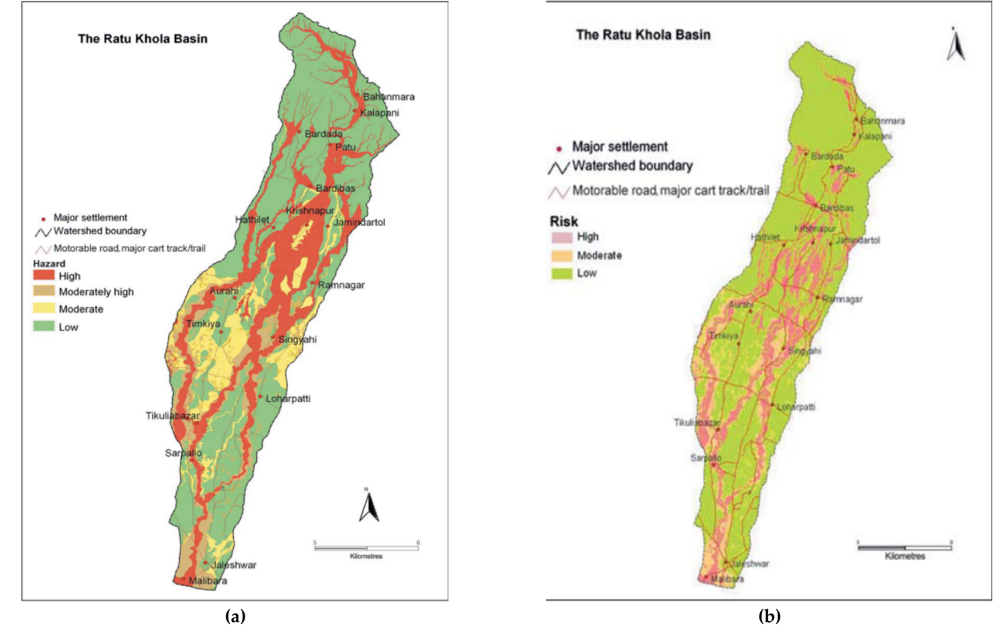
2. Study Area
3. Research Methodology
3.1. Literature Review
3.2. Overview Methodology for Flood Hazard and Risk Mapping
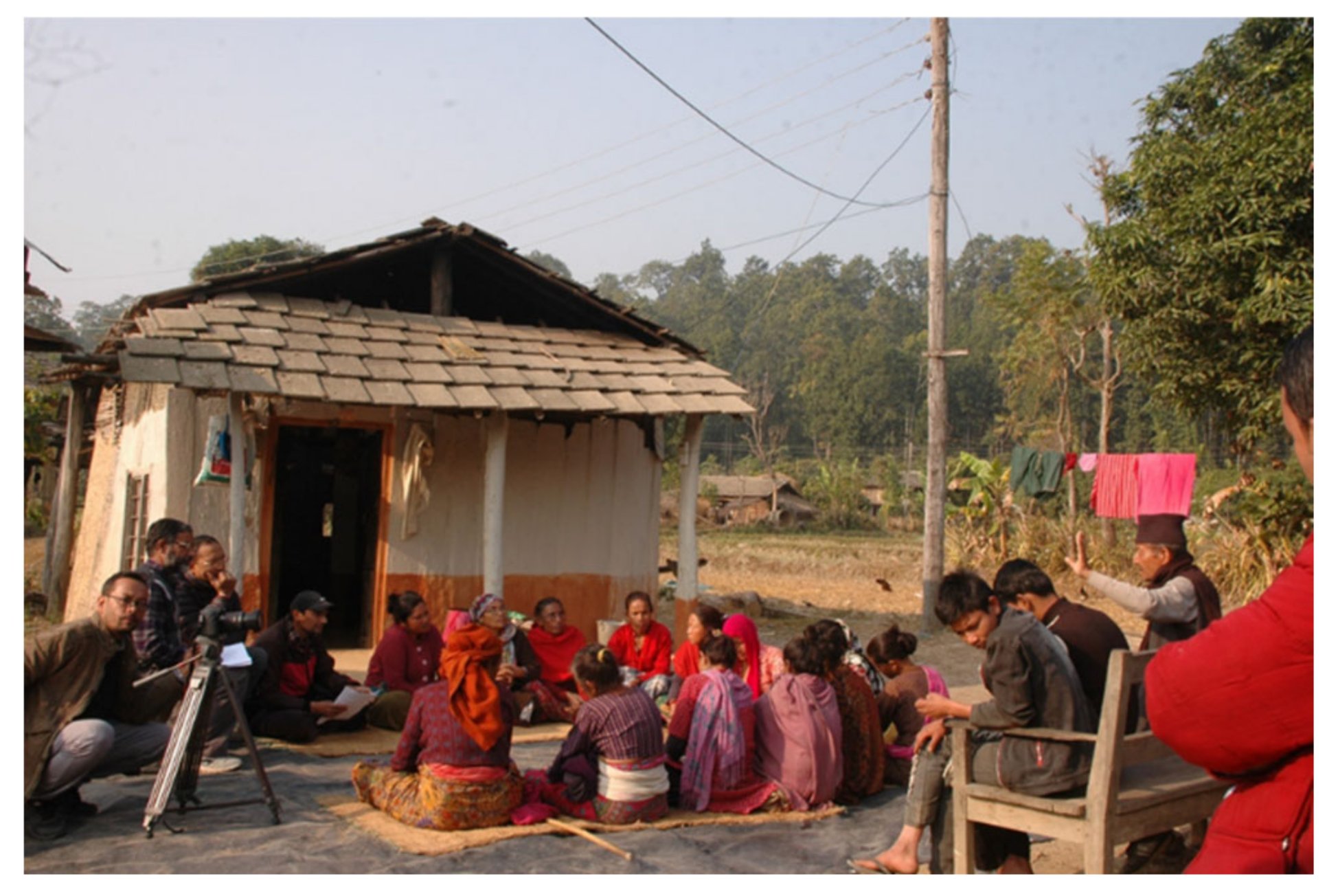
3.3. Primary Field Survey
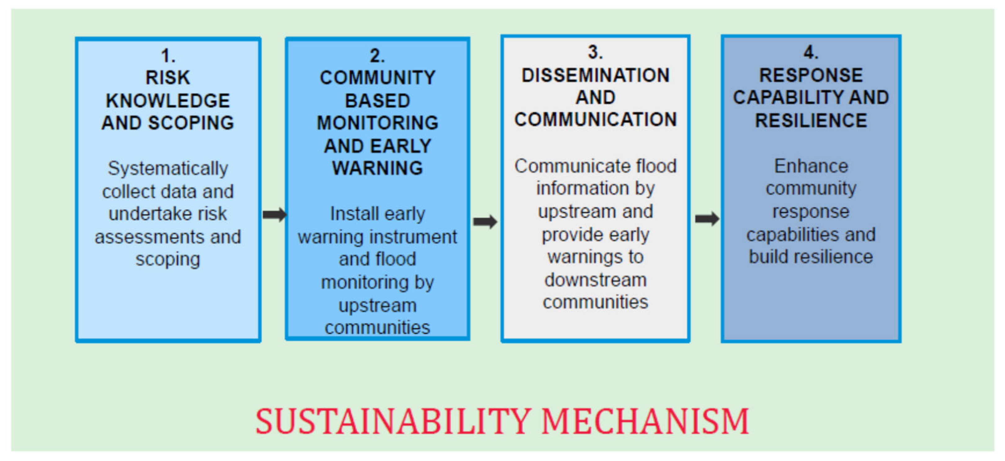
4. Community-Based Flood Early Warning System
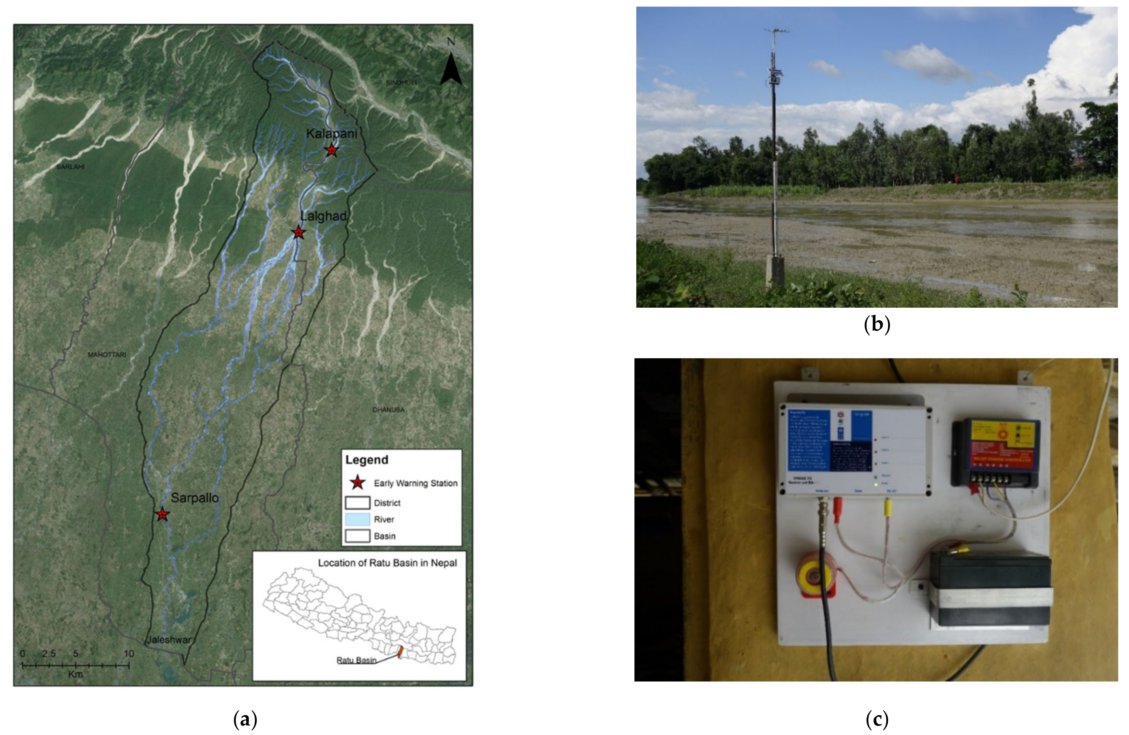
4.1. Intervention of CBFEWS in Ratu watershed
4.2. Mode of Operation
5. Results and Discussion
5.1. Community Risk Knowledge
5.2. Community-Based Monitoring and Early Warning
5.3. Dissemination and Communication
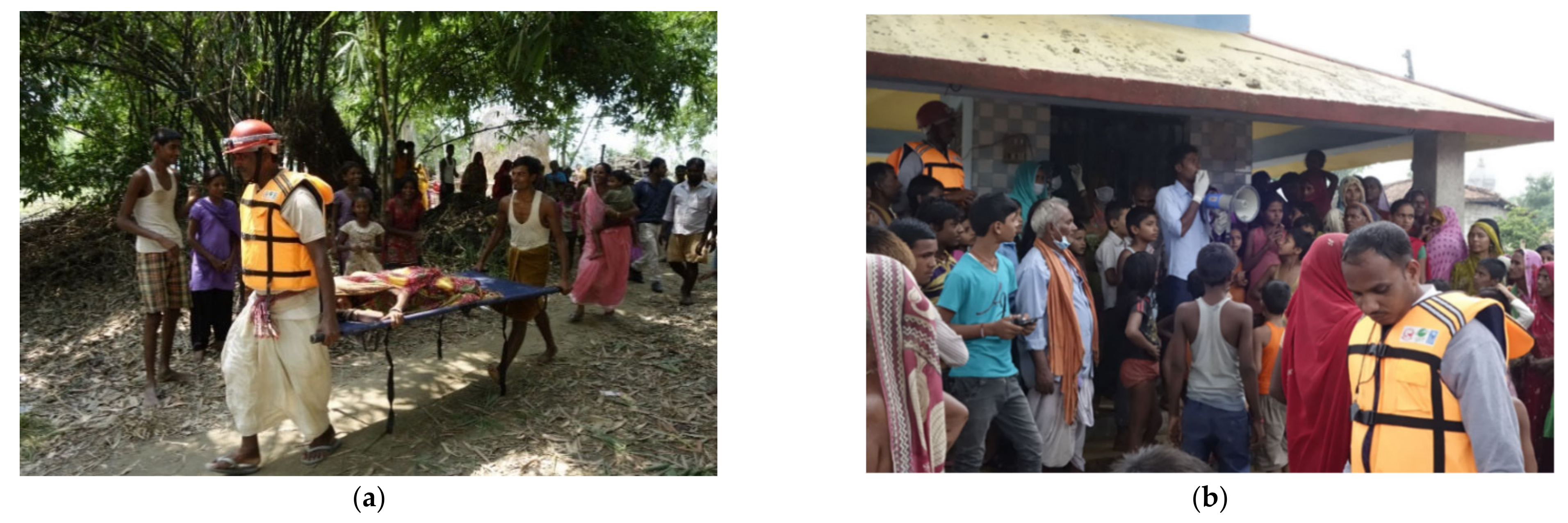
5.4. Response Capabilities and Building Resilience
6. Role of Institutions in Mitigating Flood Disaster
7. Conclusions
Author Contributions
Funding
Institutional Review Board Statement
Informed Consent Statement
Data Availability Statement
Acknowledgments
Conflicts of Interest
Abbreviations
| CBFEWS | Community-Based Flood Early Warning System |
| CBOs | Community-Based Organizations |
| CDMC | Community Disaster Management Committees |
| CFGORRP | Community-Based Flood and Glacial Lake Outburst Risk Reduction Project |
| DHM | Department of Hydrology and Meteorology |
| FA | First Aid |
| FGD | Focus Group Discussions |
| FRM | Flood Risk Management |
| GLoFAS | Global Flood Awareness System |
| GPS | Global Positioning System |
| ICIMOD | International Centre for Integrated Mountain Development |
| INGOs | International Nongovernmental Organizations |
| KIIs | Key Informant Interviews |
| LSAR | Light, Search and Rescue |
| MHz | MegaHertz |
| NGO | Nongovernment Organization |
| NPR | Nepali Rupees |
| NRRC | Nepal Risk Reduction Consortium |
| RFM | Radio Frequency Module |
| SDIP | Sustainable Development Investment Portfolio |
| SEE | Sustainable Eco Engineering |
| USD | United States Dollar |
| VDC | Village Development Committee |
| VDRMC | Village Disaster Risk Management Committee |
| WWLMS V3 | Wireless Water Level Monitoring System, Version 3 |
References
- Khanal, N.R.; Shrestha, M.; Ghimire, M. Preparing for Flood Disaster Mapping and Assessing Hazard in the Ratu Watershed; ICIMOD: Kathmandu, Nepal, 2007; pp. 1–102. Available online: https://lib.icimod.org/record/7514 (accessed on 25 January 2021).
- Baruwal, A.; Emergency and Disaster Reports, Disaster Profile of Nepal. Disaster Planning for Special Libraries. 2014, Volume 1. Available online: http://www.uniovi.net/uied/Emergency_and_Disaster_Reports/EDR_1_3_2014_Nepal.pdf (accessed on 29 January 2021).
- MoHA, DPNet. Ministry of Home and Nepal Disaster Preparedness Network-Nepal Nepal Disaster Report 2009: The Hazardscape and Vulnerability; Jagadamba Press: Kathmandu, Nepal, 2009; Available online: https://archnet.org/publications/8867 (accessed on 26 January 2021).
- MoHA. Nepal Disaster Report 2019. 2019; pp. 1–54. Available online: http://drrportal.gov.np/uploads/document/1594.pdf (accessed on 25 January 2021).
- Shrestha, A.B.; Bajracharya, S.R.; Sharma, A.R.; Duo, C.; Kulkarni, A. Observed trends and changes in daily temperature and precipitation extremes over the Koshi river basin 1975–2010. Int. J. Climatol. 2017, 37, 1066–1083. [Google Scholar] [CrossRef] [Green Version]
- MoPE. Synthesis of the Stocktaking Report for the National Adaptation Plan (NAP) Formulation Process in Nepal. 2017, pp. 1–88. Available online: https://www4.unfccc.int/sites/NAPC/Documents/Parties/Final%20Technical%20Synthesis%20Report.pdf (accessed on 25 January 2021).
- Wilby, R.L.; Keenan, R. Adapting to flood risk under climate change. Prog. Phys. Geogr. 2012, 36, 348–378. [Google Scholar] [CrossRef]
- Baidya, S.K.; Shrestha, M.L.; Sheikh, M.M. Trends in daily climatic extremes of Temperature and Precipitation in Nepal. J. Hydrol. Meteorol. 2008, 5, 38–51. [Google Scholar]
- Rajbhandari, R.; Shrestha, A.B.; Nepal, S.; Wahid, S.; Ren, G.Y. Extreme climate projections over the transboundary Koshi River Basin using a high resolution regional climate model. Adv. Clim. Chang. Res. 2017, 8, 199–211. [Google Scholar] [CrossRef]
- Bajracharya, S.R.; Shrestha, M.S.; Shrestha, A.B. Assessment of high-resolution satellite rainfall estimation products in a streamflow model for flood prediction in the Bagmati basin, Nepal. J. Flood Risk Manag. 2017, 10, 5–16. [Google Scholar] [CrossRef]
- Shrestha, M.S.; Artan, G.A.; Bajracharya, S.R.; Sharma, R.R. Applying satellite-based rainfall estimates for streamflow modelling in the Bagmati basin, Nepal. J. Flood Risk Manag. 2008, 1, 89–99. [Google Scholar] [CrossRef]
- Hoedjes, J.C.B.; Kooiman, A.; Maathuis, B.H.P.; Said, M.Y.; Becht, R.; Limo, A.; Mumo, M.; Nduhiu-Mathenge, J.; Shaka, A.; Su, Z. A Conceptual Flash Flood Early Warning System for Africa, Based on Terrestrial Microwave Links and Flash Flood Guidance. ISPRS Int. J. Geo-Inf. 2014, 3, 584–598. [Google Scholar] [CrossRef] [Green Version]
- Piacentini, T.; Carabella, C.; Boccabella, F.; Ferrante, S.; Gregori, C.; Mancinelli, V.; Pacione, A.; Pagliani, T.; Miccadei, E. Geomorphology-Based analysis of flood critical areas in small hilly catchments for civil protection purposes and earlywarning systems: The case of the feltrino stream and the Lanciano Urban Area (Abruzzo, Central Italy). Water 2020, 12, 2228. [Google Scholar] [CrossRef]
- Cools, J.; Innocenti, D.; O’Brien, S. Lessons from flood early warning systems. Environ. Sci. Policy 2016, 58, 117–122. [Google Scholar] [CrossRef]
- Lamb, R.; Keef, C.; Tawn, J.; Laeger, S.; Meadowcroft, I.; Surendran, S.; Dunning, P.; Batstone, C. A new method to assess the risk of local and widespread flooding on rivers and coasts. J. Flood Risk Manag. 2010, 3, 323–336. [Google Scholar] [CrossRef]
- Pezzoli, A.; Cartacho, D.L. Extreme Events Assessment Methodology Coupling Rainfall and Tidal Levels in the Coastal Flood Plain of the Sao Paulo North Coast (Brazil) for Engineering Projects Purposes. J. Climatol. Weather Forecast. 2013, 1, 1–5. [Google Scholar] [CrossRef] [Green Version]
- Apollonio, C.; Bruno, M.F.; Iemmolo, G.; Molfetta, M.G.; Pellicani, R. Flood Risk Evaluation in Ungauged Coastal Areas. Water 2020, 5, 1466. [Google Scholar] [CrossRef]
- Apollonio, C.; Balacco, G.; Gioia, A.; Iacobellis, V.; Piccinni, A.F. Flood Hazard Assessment of the Fortore River Downstream the Occhito Dam, in Southern Italy. In Constructive Side-Channel Analysis and Secure Design; Springer International Publishing: Berlin/Heidelberg, Germany, 2017; Volume 10405, pp. 201–216. [Google Scholar]
- Tarchiani, V.; Massazza, G.; Rosso, M.; Tiepolo, M.; Pezzoli, A.; Ibrahim, M.H.; Katiellou, G.L.; Tamagnone, P.; De Filippis, T.; Rocchi, L.; et al. Community and Impact Based Early Warning System for Flood Risk Preparedness: The Experience of the Sirba River in Niger. Sustainability 2020, 12, 1802. [Google Scholar] [CrossRef] [Green Version]
- Pradhan, N.S.; Bajracharya, N.; Bajracharya, S.R.; Rai, S.K.; Shakya, D. Community Based Flood Early Warning System for the Hindu Kush Himalaya-Resource Manual. 2016, pp. 1–39. Available online: https://lib.icimod.org/record/32318 (accessed on 25 January 2021).
- Pradhan, N.; Das, P.; Gupta, N.; Shrestha, A. Sustainable Management Options for Healthy Rivers in South Asia: The Case of Brahmaputra. Sustainability 2021, 13, 1087. [Google Scholar] [CrossRef]
- Smith, P.J.; Brown, S.; Dugar, S. Community-based early warning systems for flood risk mitigation in Nepal. Nat. Hazards Earth Syst. Sci. 2017, 17, 423–437. [Google Scholar] [CrossRef] [Green Version]
- Shrestha, M.S.; Kafle, S.K.; Gurung, M.B.; Nibanupudi, H.K.; Khadgi, V.R.; Rajkarnikar, G. Flood Early Warning Systems in Nepal; A Gendered Perspective; ICIMOD: Patan, Nepal, 2014. [Google Scholar]
- Basher, R.; Page, J.; Woo, J.; Davies, M.L.; Synolakis, C.E.; Farnsworth, A.F. Global early warning systems for natural hazards: Systematic and people-centred. Philos. Trans. R Soc. A Math. Phys. Eng. Sci. 2006, 364, 2167–2182. [Google Scholar] [CrossRef]
- Thielen, J.; Alfieri, L.; Burek, P.; Kalas, M.; Salamon, P.; Thiemig, V.; De Roo, A.; Muraro, D.; Pappenberger, F.; Dutra, E. The Global Flood Awareness System (GloFAS). Comprehensive Flood Risk Management; Klijn, F., Schweckendiek, T., Eds.; Taylor & Francis Group: London, UK, 2013. [Google Scholar] [CrossRef]
- Metz, B.; Meyer, L.; Bosch, P. Climate Change 2007 Mitigation of Climate Change. 2007, Volume 9780521880, pp. 1–861. Available online: https://www.ipcc.ch/site/assets/uploads/2018/03/ar4_wg3_full_report-1.pdf (accessed on 30 January 2021).
- UN/ISDR. Global Survey of Early Warning Systems: An Assessment of Capacities, Gaps and Opportunities toward Building a Comprehensive Global Early Warning System for All Natural Hazards; Platf Promot Early Warn (UNISDR—PPEW), UN: Geneva, Switzerland, 2006; p. 48. Available online: https://www.unisdr.org/2006/ppew/info-resources/ewc3/Global-Survey-of-Early-Warning-Systems.pdf (accessed on 25 January 2021).
- WECS (Water and Energy Commission Secretariat). Water Resources of Nepal in the Context of Climate Change; WECS (Water and Energy Commission Secretariat): Kathmandu, Nepal, 2011; p. 68. Available online: https://wwfeu.awsassets.panda.org/downloads/water_resources_of_nepal_final_press_design.pdf (accessed on 25 January 2021).
- Ministry of Health and Population Division. Nepal Population Report 2011; Ministry of Health and Population Division: Kathmandu, Nepal, 2011.
- Khandker, S.; Gayatri, S.; Hussain, K. Handbook on Impact Learning; 2009; Volume 1, p. 262. Available online: http://documents1.worldbank.org/curated/en/650951468335456749/pdf/520990PUB0EPI1101Official0Use0Only1.pdf (accessed on 25 January 2021). [CrossRef]
- Pomeranz, D. Impact Evaluation Methods in Public Economics: A Brief Introduction to Randomized Evaluations and Comparison with Other Methods. Public Financ. Rev. 2017, 45, 10–43. [Google Scholar] [CrossRef] [Green Version]
- Campbell, C.R.; Martinko, M.J. An integrative attributional perspective of empowerment and learned helplessness: A multimethod field study. J. Manag. 1998, 24, 173–200. [Google Scholar] [CrossRef]
- United Nations. Yokohama Stategy and Plan of Action for a Safer World; World Conf Disaster Reduct; United Nations: Geneva, Switzerland, 1994; pp. 23–27. [Google Scholar]
- United Nations. International Strategy for Disaster Reduction Hyogo Framework for Action 2005–2015: Building the Resilience of Nations; World Conf Disaster Reduct; United Nations: Geneva, Switzerland, 2005; p. 25. Available online: https://www.unisdr.org/files/1037_hyogoframeworkforactionenglish.pdf (accessed on 28 January 2021).
- Teitelbaum, L.; Ginsburg, M.L.; Hopkins, R.W. Cognitive and Behavioural Impairment among Elderly People in Institutions Providing Different Levels of Care. CMAJ 1991, 144, 169–173. [Google Scholar] [PubMed]
- UNISDR. Developing Early Warning Systems: A Checklist. Third Int Conf Early Warn; UN/ISDR: Bonn, Germany, 2006; pp. 1–13. Available online: https://www.unisdr.org/2006/ppew/info-resources/ewc3/checklist/English.pdf (accessed on 25 January 2021).
- Macherera, M.; Chimbari, M.J. A review of studies on community based early warning systems. J. Disaster Risk Stud. 2016, 8, 1–11. [Google Scholar] [CrossRef]
- Mercy Corps and Practical Action. Establishing Community-Based Early Warning System: Practitioner’s Handbook; Mercy Corps Nepal: Lalitpur, Nepal, 2010; pp. 1–69. Available online: https://answers.practicalaction.org/our-resources/item/establishing-community-based-early-warning-system-practitioner-s-handbook (accessed on 31 January 2021).
- Gautam, D.K.; Phaiju, A.G. Community Based Approach to Flood Early Warning in West Rapti River Basin of Nepal. J. Integr. Disaster Risk Manag. 2013, 3, 155–169. [Google Scholar] [CrossRef]
- Fakhruddin, S.; Kawasaki, A.; Babel, M.S. Community responses to flood early warning system: Case study in Kaijuri Union, Bangladesh. Int. J. Disaster Risk Reduct. 2015, 14, 323–331. [Google Scholar] [CrossRef]
- Koussis, A.D.; Lagouvardos, K.; Mazi, K.; Kotroni, V.; Sitzmann, D.; Lang, J.; Zaiss, H.; Buzzi, A.; Malguzzi, P. Flood Forecasts for Urban Basin with Integrated Hydro-Meteorological Model. J. Hydrol. Eng. 2003, 8, 1–11. [Google Scholar] [CrossRef]
- Agbola, B.S.; Ajayi, O.; Taiwo, O.J.; Wahab, B.W. The August 2011 flood in Ibadan, Nigeria: Anthropogenic causes and consequences. Int. J. Disaster Risk Sci. 2012, 3, 207–217. [Google Scholar] [CrossRef] [Green Version]
- Hajito, K.W.; Gesesew, H.A.; Bayu, N.B.; Tsehay, Y.E. Community awareness and perception on hazards in Southwest Ethiopia: A cross-sectional study. Int. J. Disaster Risk Reduct. 2015, 13, 350–357. [Google Scholar] [CrossRef]
- Singh, M.; Devkota, L.P. People’s Perspective on Flood Hazard and Adaptation Strategies in the Koshi River Basin of Nepal. IOSR J. Humanit. Soc. Sci. Ver. II. 2015, 20, 33–45. [Google Scholar]
- ICIMOD. Transforming River Basin Management: Stories from the Koshi Basin; ICIMOD: Kathmandu, Nepal, 2016; pp. 1–67. Available online: http://lib.icimod.org/record/31841 (accessed on 30 January 2021).
- Rogers, D.; Tsirkunov, V. Implementing Hazard Early Warning Systems; Global Facility for Disaster Reduction and Recovery: Washington DC, USA, 2011; Volume 11, pp. 1–47. Available online: http://www.preventionweb.net/files/24259_implementingearlywarningsystems1108.pdf (accessed on 25 January 2021).
- Oktari, R.S.; Munadi, K.; Ridha, M. Effectiveness of Dissemination and Communication Element of Tsunami Early Warning System in Aceh. Procedia Econ. Financ. 2014, 18, 136–142. [Google Scholar] [CrossRef] [Green Version]
- Nazli, N.N.N.N.; Sipon, S.; Radzi, H.M. Analysis of Training Needs in Disaster Preparedness. Procedia-Soc. Behav. Sci. 2014, 140, 576–580. [Google Scholar] [CrossRef] [Green Version]
- Madan, A.; Routray, J.K. Institutional framework for preparedness and response of disaster management institutions from national to local level in India with focus on Delhi. Int. J. Disaster Risk Reduct. 2015, 14, 545–555. [Google Scholar] [CrossRef]
- Driessen, P.P.J.; Hegger, D.L.T.; Bakker, M.H.N.; Van Rijswick, H.F.M.W.; Kundzewicz, Z.W. Toward more resilient flood risk governance. Ecol. Soc. 2016, 21, 53. [Google Scholar] [CrossRef]
- Scolobig, A.; Prior, T.; Schröter, D.; Jörin, J.; Patt, A.G. Towards people-centred approaches for effective disaster risk management: Balancing rhetoric with reality. Int. J. Disaster Risk Reduct. 2015, 12, 202–212. [Google Scholar] [CrossRef]


| Source of Information | Before (2015) | After (2016) | ||
|---|---|---|---|---|
| No of Household | % | No of Household | % | |
| Local government | 12 | 6.7 | 12 | 6.7 |
| National government | 2 | 1.1 | 18 | 10.0 |
| NGOs | 9 | 5.0 | 2 | 1.1 |
| Television/ FM radio | 39 | 21.7 | 11 | 6.1 |
| CBOs | 10 | 5.6 | 11 | 6.1 |
| Community workers | 19 | 10.6 | 47 | 26.1 |
| Village head | 4 | 2.2 | 3 | 1.7 |
| Newspaper | 1 | 0.6 | 3 | 1.7 |
| Caretaker (Mobile phone) | 0 | 0.0 | 30 | 16.7 |
| EW network | 0 | 0.0 | 68 | 37.8 |
| Response | 2015 | 2016 | ||
|---|---|---|---|---|
| No of Household | % | No. of Household | % | |
| Yes | 9 | 5.0 | 98 | 54.44 |
| No | 171 | 95.0 | 82 | 45.56 |
| Total | 180 | 100.0 | 180 | 100.0 |
| Method of Communication | Before (2015) | After (2016) | ||
|---|---|---|---|---|
| No of Household | % | No of Household | % | |
| Telephone | 9 | 5.0 | 1 | 0.6 |
| Wireless radio | 4 | 2.2 | 42 | 23.3 |
| Siren | 120 | 62.2 | 153 | 85.0 |
| Megaphones | 27 | 15.0 | 59 | 32.8 |
| SMS | 41 | 22.8 | 103 | 57.2 |
| Radio FM | 13 | 7.2 | 32 | 17.8 |
| TV | 0 | 0.0 | 1 | 0.6 |
Publisher’s Note: MDPI stays neutral with regard to jurisdictional claims in published maps and institutional affiliations. |
© 2021 by the authors. Licensee MDPI, Basel, Switzerland. This article is an open access article distributed under the terms and conditions of the Creative Commons Attribution (CC BY) license (http://creativecommons.org/licenses/by/4.0/).
Share and Cite
Bajracharya, S.R.; Khanal, N.R.; Nepal, P.; Rai, S.K.; Ghimire, P.K.; Pradhan, N.S. Community Assessment of Flood Risks and Early Warning System in Ratu Watershed, Koshi Basin, Nepal. Sustainability 2021, 13, 3577. https://0-doi-org.brum.beds.ac.uk/10.3390/su13063577
Bajracharya SR, Khanal NR, Nepal P, Rai SK, Ghimire PK, Pradhan NS. Community Assessment of Flood Risks and Early Warning System in Ratu Watershed, Koshi Basin, Nepal. Sustainability. 2021; 13(6):3577. https://0-doi-org.brum.beds.ac.uk/10.3390/su13063577
Chicago/Turabian StyleBajracharya, Sagar Ratna, Narendra Raj Khanal, Pashupati Nepal, Sundar Kumar Rai, Pawan Kumar Ghimire, and Neera Shrestha Pradhan. 2021. "Community Assessment of Flood Risks and Early Warning System in Ratu Watershed, Koshi Basin, Nepal" Sustainability 13, no. 6: 3577. https://0-doi-org.brum.beds.ac.uk/10.3390/su13063577