
Spatial Configurations and Walkability Potentials. Measuring Urban Compactness with Space Syntax


1
Department of Civil Engineering, Western Norway University of Applied Sciences, 5020 Bergen, Norway
2
Department of Urbanism, Faculty of Architecture, TU-Delft, 2628 BL Delft, The Netherlands
Sustainability 2021, 13(11), 5785; https://0-doi-org.brum.beds.ac.uk/10.3390/su13115785
Submission received: 5 March 2021
/
Revised: 26 April 2021
/
Accepted: 18 May 2021
/
Published: 21 May 2021
(This article belongs to the Special Issue Space Syntax and the Sustainable City: Theory, Methods and Applications)
Abstract
:This contribution demonstrates how space syntax methods on various scale levels can be used to identify and describe the spatial features of a compact city. Firstly, the term urban compactness is discussed. A short discussion of some writings on the compact city are elaborated. As it transpired, urban compactness can best be approached from a spatial topological point of view, since compactness is a topological property. Secondly, urban compactness will be reconsidered in spatial configurative terms through the use of space syntax and urban micro scale tools. Examples from car-, pedestrian-, and public transport-based centres in Oslo and Bergen will be used throughout this contribution. Discussions of the examples in this contribution are discussed with references to other space syntax research results. As the case studies show, enhancing compact neighbourhoods with good walkability potential from a spatial perspective relies on spatial interaccessibility on all scale levels. Accessibility depends on spatial configurative compactness. Seemingly, it depends on the following complex set of sufficient conditions: a spatially integrated street network on all scale levels, short urban blocks and streets with building entrances with windows and doors on the ground floor level.
1. Introduction—Conditions for Urban Compactness
This contribution attempts to answer how a spatial configurational approach of the built environment can contribute to identifying the spatial features of a compact city. The focus is on to reveal the spatial features of urban compactness—whether an urban centre or neighbourhood has walkability potential or not.
There exist several writings on the social, economic, political and environmental aspects of sustainable cities dating back to the 1990s. This led to the proposal of a set of 17 sustainability goals in September 2015 at the UN Sustainable Development Summit [1]. Relevant for urban studies are sustainability goals 3 (good health and well-being), 5 (gender equality), 7 (affordable and green energy), and 11 (to make cities and human settlements inclusive, safe, resilient and sustainable).
Regarding the physical aspects of built environments, there exist several pieces of writing on sustainable building materials, recycling processes, conditions for sustainable ways for heating or cooling of buildings, and so forth [2]. However, the spatial parameters (including the spaces shaped by physical objects such as buildings) are not always taken into account. This contribution aims to reveal the spatial parameters for generating walkable neighbourhoods and compact well-functioning vital local urban centres. How can these spatial parameters be measured and analysed? Proper analysis methods and knowledge gained from research are particularly necessary for evaluating urban planning and design proposals. The overall purpose is to discover to what extent these planning and design proposals can generate sustainable means of its users.
The focus of this contribution is specifically on a built environment’s walkability potentials. It is not enough to enhance a good public transport system to urban centres. The built environment has also to offer the spatial conditions for walking the last meters or kilometres towards the final destinations. Facilitating walkable cities does not only concern a provision of sidewalks. A wide range of other issues are also at stake, such as safe and gender-equal public spaces and streets, a natural variation of experiences on the way, and a wide range of urban functions and activities within a short distance.
The overall question is about how the space syntax method can describe the spatial properties of a compact city with high walkability potential. As presumed in most pieces of writing, a city is sustainable when the city is compact. For this, the conceptual framework regards compactness needs first to be discussed in relation to writings on compact cities. For this, the application of modal logics from George Henrik von Wright is applied. The focus is on the necessary conditions as to why something becomes possible, and on the sufficient conditions as to why something becomes necessary [3]. In the urbanism discipline, the largest current challenge is to enhance sustainable mobility means. The focus in this contribution is on the walkability potential, as the last meters from public transport stops and daily activities on a neighbourhood scale level influence to what extent one chooses to walk or to use a car.
Secondly, the next step is to discuss current space syntax theories and to show some space syntax examples of urban areas that are considered to be compact or not for the two Norwegian cities Oslo and Bergen. Both cities have large variations of urban areas, in line with other cities around the globe. In addition, private car ownership in Norway belongs currently to the top 24 countries in the world with 514 cars per 1000 people. Since 2016, there has been a shift in urban planning in Norway where the focus is on making city centers car-free [2]. As it turns out, the space syntax method is able to reveal with precision the spatial components of a compact city. In line with current space syntax theories, high building density and land use diversity depends on a compact, well-connected and spatially integrated street network and short topological distances between private and public space. At the end of this article, it will be discussed how these spatial conditions can enhance safe and vital streets attractive for walking.
2. Writings on Compact Cities
Since the 1990s, there have been several writings on sustainable cities. From the Millennium onwards, the term compact city has often been used. Some of these writings are discussed here in this section. Firstly, an introduction on urban sustainability and a definition of urban compactness is given. Secondly, an elaboration on sufficient and necessary conditions for walkability is applied to the relationship between walkability and urban compactness. Thirdly, some writings on compact cities are discussed. Finally, a shift is made towards the role of the mobility network and urban compactness. This will be discussed with regards to various space syntax theories at the end.
2.1. Sustainable Development, Urban Sustainability and Moving towards the Compact City Concept
The subject of sustainability was introduced for good reasons. Christian Patermann, the director of the Environmental and Sustainable Development research programme, noticed that during the 20th century, cities tended to put economic expansion on their agendas. They did so at the cost of social well-being and environmental equilibrium. The social effects are, for instance, placelessness, exclusion, insecurity, crime, and a loss of cultural identity. The environmental effects are, among others, poor air quality, pollution, and low-density urban sprawl. Furthermore, the effects of traffic congestion and deteriorating infrastructure and built environments have affected the locations of economic activities [4].
The Brundtland report of 1987 and the 1992 Earth Summit in Rio de Janeiro rightly predicted that in the beginning of this century more than 50% of the world’s population will live in urban areas [5]. During the last decades, increased energy use for transportation in urban areas contributed to the greenhouse effect and climate change. In these contexts, the concept of sustainable development was considered and became fashionable in the 1990s. After the millennium, several concrete policies were made in various countries for generating sustainable cities and communities [2,6]. However, most of them have a normative approach, based on thin descriptive knowledge.
There are numerous definitions of the term ‘sustainable development’. According to the 1992 Earth Summit in Rio de Janeiro, sustainable development is defined as a “development which meets present needs without compromising the ability of future generations to achieve their needs and aspirations” [7] (p. 233). A major problem in defining sustainability in this manner results from the term’s normative as well as descriptive aspects. From a normative point of view, questions of the following kind seem appropriate: Should something be sustainable and what should be done to guarantee its sustainability? In this case, the intentions are to assess a certain goal in terms of sustainability. The descriptive aspects of sustainability, however, concern what actually is sustainable. If intentions of future generations are taken into account at present, it is difficult to guarantee to what extent it will be sustainable in the future. Accessing whether scientists or politicians propose a normative or descriptive understanding of sustainability is difficult. For the suggestions proposed in the Brundtland Report concern the present as well as future needs, hence not just descriptive, but likewise normative matters.
At the millennium, various strategies and proposals on how to achieve a sustainable city were prioritized [1,8,9]. Yet, what is a sustainable city? Is it an object or a process? Sustainable, according to the quoted definitions, indicates that a city is not an object but a development or process. That is to say a development influenced by or consisting in human interaction. Urban sustainability is a particular case of sustainability. If sustainability is about processes, then the term ‘sustainable urban development’ is more appropriate than a ‘sustainable city’. Conversely, the concept ‘sustainable city’ or the more recently used ‘compact city’ is about the physical aspect of built environments. Here the city is treated as an object. A clear distinction between the city as a transformation process and an object is lacking in many recent writings about sustainable built environments. Moreover, the distinction between what is a sustainable city and what should be a sustainable city is not always clear. Probably, the concept ‘compact city’ was a first step to make a distinction between the city as an object and to distinguish it from sustainable urban processes.
Still, we have no clear ideas of what a sustainable city is and what a sustainable city would look like. Already in the 1990s, the concept of compact city was used. The idea behind it is that all urban functions are located at a walkable distance from each other for reducing energy use for transport per visitor and inhabitant. The more diverse functions and the higher density of the buildings within a short metrical distance, the more the neighbourhood enhances its walkability and can serve a public transport stop with a high frequency of services. Examples from traditional urban centres are used as examples of compact cities.
The compact city concept is in contrast with the green city concept. Johan Rådberg states that we have a density paradox. On the one hand, a compact city has high density of the built mass and short distances from the edges to the centres, implying short travel distances, less pollution, and less energy use and time for transport. On the other hand, the green city has available land for organic local waste, recycling, waste water infiltrations, and cultivations, implying urban sprawl into the countryside [10]. As Rådberg claims, we need operational methods for identifying the spatial parameters on an urban block level rather than on a city level, to be able to make operational densification strategies. Operational methods depend first and foremost on clear and well-defined definitions of the components that are at stake.
2.2. Definitions of the Compact City and its Conditions
There are numerous writings on urban areas and their sustainable development. Most of them set out as a criticism on Le Corbusier’s Radiant City model, Ebernezer Howard’s Garden City model, Frank Lloyd Wright’s individualistic dwelling model, and general post-war planning. These kinds of anti-urban city models and planning are recognised to contribute to a separation of functions and simplification of urban areas [7,8,9,11,12]. What all these authors search for is an understanding of the compact city model, which is recognised to encourage sustainable ways of living and low energy use for transportation. Generally speaking, urban sustainability is thus accounted for in terms of compactness. In one way or another, a city’s compactness is taken to condition a sustainable urban development. In essence, this contribution is intended to render this thesis somewhat more precise. At least the following features are recognised from recent writings to be essential to compact cities:
- Physical aspects: High density of the built mass in central areas and sub-centres, pedestrian-friendly streets, and clear demarcation of what is public and private space.
- Functional aspects: Dense location and mixed use of dwellings, work, services, retail and shops in urban areas, short movement routes between facilities, pedestrian-friendly, dense concentration of people, access to public transport, and an intensifying of human activities in the urban centres.
- Social aspects: Low crime, mixture of people of different class and race, healthy and good dwelling areas, safe streets, possibilities for social contact between inhabitants and visitors.
- Economic aspects: Vital centres and sub-centres and a mixture of small and large enterprises in urban areas.
- Environmental aspects: Reduction of energy use, new development on recycled land, and reduction of low-density urban sprawl in the countryside.
- Political aspects: The ways in which governments on the local, regional, and national level should act or not in order to encourage sustainable development rather than the opposite.
Is then the compact city a product of walkability? Or is walkability possible in terms of compactness? Initially, compactness is a topological property. In a very loose and scientific way of speaking, compact is what is closely and firmly united, pressed together, dense, fine-grained and packed into a small space [13]. In addition to quantitative aspects, the qualitative, economical, and aesthetic aspects of the term are thus mentioned.
What are then the spatial conditions for walkable urban areas? As von Wright claims, explaining cause–effect relations relies on identifying the particular sufficient condition as to why something became necessary. When there are several conditions involved, a complex set of necessary conditions are used. The explanation models used with regards to cause–effect relations pertain to the positivistic research tradition, and they are context-independent. The level of predictability is high, and these explanation models are used for theory building [3]. Conversely, understanding a phenomenon depends on identifying the necessary condition as to why something became possible. Where several conditions are involved, a complex set of sufficient conditions are used in these types of explanation models. Explanations models involving human intentions require a hermeneutic approach, where the aim is to understand a phenomenon [3]. The application of these explanation models is useful for testing out the explanatory power of various general statements and theories on built environments [14]. At least two hypotheses may be proposed regarding the compact city:
- A city is not walkable unless the city in question is compact. Thus, compactness of urban environments is a necessary condition for walkability.
- Compactness guarantees walkability. It is a sufficient condition for walkability.
Is then urban compactness a sufficient condition or a necessary condition for walkability? Or is it neither–nor? So far, it seems difficult to make general statements on the physical conditions for walkable cities because a concise definition of urban compactness is missing. Presumably, urban compactness can contribute to a certain kind of walkability, but in which way depends on what is meant by compactness. Here, a short briefing of some of the most influential writings on urban compactness might be helpful.
2.3. Influencial Writings Related to Compact Cities
Jane Jacobs’s book The Death and Life of Great American Cities introduces different ways than those of urban planners and architects for understanding cities in terms of the social behaviour in the city, the economic behaviour of cities, generally speaking, the way in which cities are used and function. Her main message is that life on streets makes the city lively. A well-used city and diversity in cities create safe streets [15] (p. 44). She makes the following suggestions for enhancing lively and safe cities: short urban blocks, a high mixture of various urban functions, eyes on the streets from adjacent buildings, and safe sidewalks. Her conclusions are based on observations in well-functioning traditional urban areas. Jacobs’ account of urban compactness illustrates methods in the qualitative social science. She does not rely on quantitative measures falsifying or confirming her observations. Her work consists of descriptions of essential spatial features. She offers some normative directions as to how things should be to ensure livable cities with a strong focus on the pedestrian.
A different kind of approach is offered by Christopher Alexander’s article A City is Not a Tree. It is a criticism of the modern planned structure of cities. Alexander discusses the structure of information processing of human beings in society. He does not set out from observations, but proposes a formal approach. Alexander tries to give an explanation as to why many cities do not fulfil the social task for which they were designed. Regarding their inner organisation, natural cities have the form of a ‘semi-lattice’, whereas artificial ones have a ‘tree structure’. According to Alexander, a city with a tree structure is divided into different zones. Each zone has a set of functions not relating to other zones [16] (p. 51). For Alexander, organising cities in the form of trees is a means of simplifying the spatial organisation of the complex environment. Cities with a semi-lattice structure usually dispose of a complex transportation network. The different zones overlap with each other and are well-integrated with one another. According to Alexander, this structure improves a city’s economic development, its safety and its liveliness.
Through Alexander’s work, urban compactness can be understood in terms of the complexity of the transportation network and the intertwined functions of the semi-lattice-structured cites. However, consequences regarding further improvements of urban compactness are not discussed in his work.
While the writings from the 1960s were concerned with the social, economic, and communicative aspects of the compact city, environmental issues and sustainability were explicitly taken into consideration in more recent writings. Richard Rogers’s approach to urban sustainability involves reinterpreting and reinventing the dense city model. It is defined to consist of anti-zoning, an increase in energy efficiency, consuming fewer resources, producing less pollution and avoiding sprawl into the countryside [8] (p. 33).
Like Jane Jacobs, Rogers discusses the compact and well-connected city. In a sense, he takes up principles introduced by Jane Jacobs. Rogers makes proposals on how a compact city should be designed. He does not specify how such a design is brought about, but makes normative statements on how things should be done to achieve a compact urban form. A comprehensive understanding of the economic and social behaviour of a compact city’s inhabitants and visitors is missing in Rogers’s books. As future human beings will have their own values and intentions, it is, in principle, difficult to guess or even know what their future will be.
Like Jacobs’ writings, Peter Calthorpe’s book, The Next American Metropolis emphasises the role of the pedestrian and the mixed usage of urban space in neighbourhoods. His concept of the pedestrian pocket accounts for the idea of an opportunity for walking distances for all kinds of people to all activities from home. Therefore, he introduces the ‘Transit Oriented Development’ concept in a word ‘TOD’. Calthorpe explains TOD as follows: “moderate and high-density housing, along with public uses, jobs, retail and services are concentrated in mixed-use developments at strategic points, along the regional transit system” [11] (p. 41). Like Rogers, this author promotes a normative approach. Calthorpe makes proposals as to what should be done to produce ecologically, economically and socially sustainable urban areas. However, what is missing is a genuine understanding of how the built environment and the generative power of the urban street network itself are working. Calthorpe’s proposals refer to the regional scale and to the scale of the urban block. However, the spatial organisation of a neighbourhood unit and its location in the city as a whole are not discussed at all.
Most writings on compact or sustainable cities describe the problems that built environments are facing today regarding sustainability. The various authors offer quick proposals on how to design or plan a compact city. But what is missing is a concise understanding of how compact cities function regarding their social and economic activities. Some recent attempts are made to write on the physical conditions of the built environment. Examples are Stephen Marchall’s street network and junction typologies [17], Nico Salingaros criticism on modernism based on CIAM’s principles from the 1933 [9], Caromona et al.’s approach to describe various spatial and morphological aspects of urban areas [12], and Rådberg’s classification system on building density and typology [10] which was later named Spacematrix [14,18,19,20].
2.4. The Mobility Network and Urban Compactness
According to the Brundtland report, one of the basic environmental problems of modern cities is high energy use for transportation—generally speaking, car dependency [6]. Does this relate to the spatial structure of the mobility network? Public spaces between buildings are potential movement routes from everywhere to everywhere else [21]. The way in which the functions in an urban street network are dispersed must, to a substantial extent, result from potential movement routes through these public spaces. First and foremost, density and a mixture of activities depend on the spatial structure of an urban street and road network [18,19,20]. Car dependency is one of the issues illustrating the technological complexity debates on urban sustainability. The subsequent account of compactness will reckon with this precondition.
On the other hand, cultural interaction, perception on street safety, and physical movement certainly shape a built environment [21,22,23]. There is interdependence between the physical built environment and economical as well as socially motivated movement. Thus, physical form and how human beings behave in it influence each other. Urban compactness thus should be understood in terms of movement and interaction and their relationship to urban space.
How is it possible to find out whether compactness is a necessary or sufficient condition for walkability given that concepts of urban compactness are imprecise? Even though the writings above indicate to some extent what a compact city might be, the concept of density is still vague and the concept of the spatial structure of a street network is unclear. If compactness is basically a topological property, it certainly makes sense to use a topological consideration to understand or explain urban compactness. The following subsection will set out to explore in which way a spatial configurative approach can offer a more concise account of urban compactness than most writings on this topic.
2.5. The Spatial Configurative Approach—Space Syntax
An account of compactness in spatial configurative terms has to be descriptive. It concerns both structural and social aspects. While Alexander concentrated on structural aspects and while Jacobs accounted for social aspects, a space syntax approach offers mathematical means to reconsider them jointly. Compactness is then understood in terms of urban space, and various ways to describe and measure the spatial properties of built environments that are recognised to be sustainable or the opposite.
First and foremost, an approach of this kind requires a concise definition of urban space. Regarding research on built environments, Bill Hillier distinguishes between intrinsic and extrinsic properties of space. Extrinsic ones determine how spatial units relate to one another, thus about the configurative laws of space. From this perspective, primarily topological issues become relevant. Extrinsic properties of space determine both built form and its possible function. While extrinsic properties of space consist in invisible, structural relationships, intrinsic properties relate to visible ones. They present themselves mostly through geometrical properties, pattern and texture. They account for the articulation of social meaning via built form [24].
The elements that all built environments have in common are extrinsic properties of space and functions occupying these spaces. Thus, from a spatial configurative point of view, a city is conceived as a set of spaces. Urban space is mostly linear. It consists in mostly streets, alleys, roads, boulevards, highways, which, in contrast with squares, are linear items. Spaces of these kinds can be represented as linear items such as axial sightlines or segment lines [25]. The axial and segment map is the basis for calculating the interrelationship of these lines, in particular their topological distance from one another. Topological distance is about calculating how every street is related to all others in terms of the total number of direction changes.
According to Hillier, economic and social activities are influenced by the spatial structure of a city as an object [25]. The kind of rationale behind economic activities in cities is that the predominant implicit intention is profit maximising. All cultures exhibit this feature [14]. In a free market, shops and retail owners choose the most optimal location to reach as many potential customers as possible. While the rationale behind economic activities is rather unambiguous, the rationale behind social activities depends on an understanding of society and cultures [14].
The Space Syntax method, developed by Bill Hillier and his colleagues at University College London, consists of calculating and describing spatial configurative inequalities in an urban street and road network. These calculations have been compared with the registration of human movement, social and anti-social behaviour and location patterns of shops, dwellings, social and cultural institutions. As world-wide research has shown, streets with the highest spatial integration have the highest flow of human movement and tend to be the economic centres in towns and cities [26,27]. There exist the following three space syntax theories with clear cause–effect relations [14]:
The theory of spatial combinatorics focuses on what happens with the level of spatial integration when blocking longer or shorter streets, or placing long or curled up buildings in urban space. The focus is on the city as an object. As various model studies show, the findings are in line with Jane Jacobs’s presumptions. Short urban blocks integrate spatially more than large urban blocks, which implies higher accessibility. Compact curled up buildings spatially integrate a neighbourhood more than long buildings, which implies higher permeability for pedestrians.
The theory of the natural movement or natural movement economic process states that the degree of spatial integration of the street and road network influence the flow of movement. Shops locate themselves along the highest integrated streets. Higher spatial integration leads to greater flow of movement. The theory does not state in what way the movement takes place, by car or by foot.
The theory of the natural urban transformation process states that the degree of spatial integration of the street and road network influences the degree of land use diversity and building density. The higher integration on the street and road network, the higher building density and the higher land use diversity. Low spatial integration on the street and road network contributes to low density monofunctional urban areas and to urban sprawl.
These theories have high levels of predictability, and pertains to sufficient conditions [14]. Only one new street link or blocking a street is a sufficient condition for a change in the spatial integration of the street network. If the spatial integration of an optimal location for shops is affected, shops will relocate themselves to another optimal location [29]. If the spatial integration of the street and road network increase, the accessibility to adjacent land increases, and so the attraction increases.
The success of the space syntax method and its theories is grounded in the precision of the spatial elements used, high level of falsifiability and testability and high levels of empirical support. Throughout the years, the calculations have been refined, applied on a large variety of built environments, and to strengthen and develop descriptive theories on urban space [30].
The next step is to discuss how these space syntax theories can contribute to the compact city debate. Results from previous space syntax studies are discussed with reference to the various space syntax analyses of Oslo and Bergen.
3. Materials and Methods
An axial map of Oslo and Bergen was drawn manually. In addition, some data are available for both cities regard energy use for transport, building density and degree of land use diversity. The location pattern of shops was registered manually.
Space syntax classical axial integration analyses consist of analysing how each axis relates to all others in terms of the total number of direction changes. The integration (I) of an axial line (i) is a function of its topological depth related to all other axes. The calculation behind the integration of an axial line is [31] (p. 64):
where n is the number of segments and dij is the shortest distance (least number of direction changes) between two segments i and j. The greater the number of direction changes or topological steps (dij) between street axes, the lower the integration values become. Conversely, the lower the number of the total number of direction changes to all other axis, the higher the spatial integration. Later, the axial map was broken up to segments at every junction. This makes it possible to add angular weighting between each segment into the calculations. The formula of angular choice C of a segment i is as follows [31] (p. 64):
where is the number of shortest paths between segment j and k containing i, and gjk is the number of all shortest paths between j and k. The angular choice shows the through-movement potentials for each street segment in relation to all others.
The formula for the angular integration (AI) of a segment x is:
where n is the number of segments and dθ the angle between any two segments on the shortest path on a segment x and when adding the length l of segments [31] (p. 66):
The angular integration analysis shows the potential to-movement potentials. Whereas the classical space syntax analyses show mostly the to-movement potentials on various scales based only on direction changes, the angular segment and angular choice analyses takes also angular weighting and metrical properties into account. In particular, the various local metrical radius, such as how integrated a street segment is within a radius of 500 m, are of interest in indicating the level of walkability of a neighbourhood.
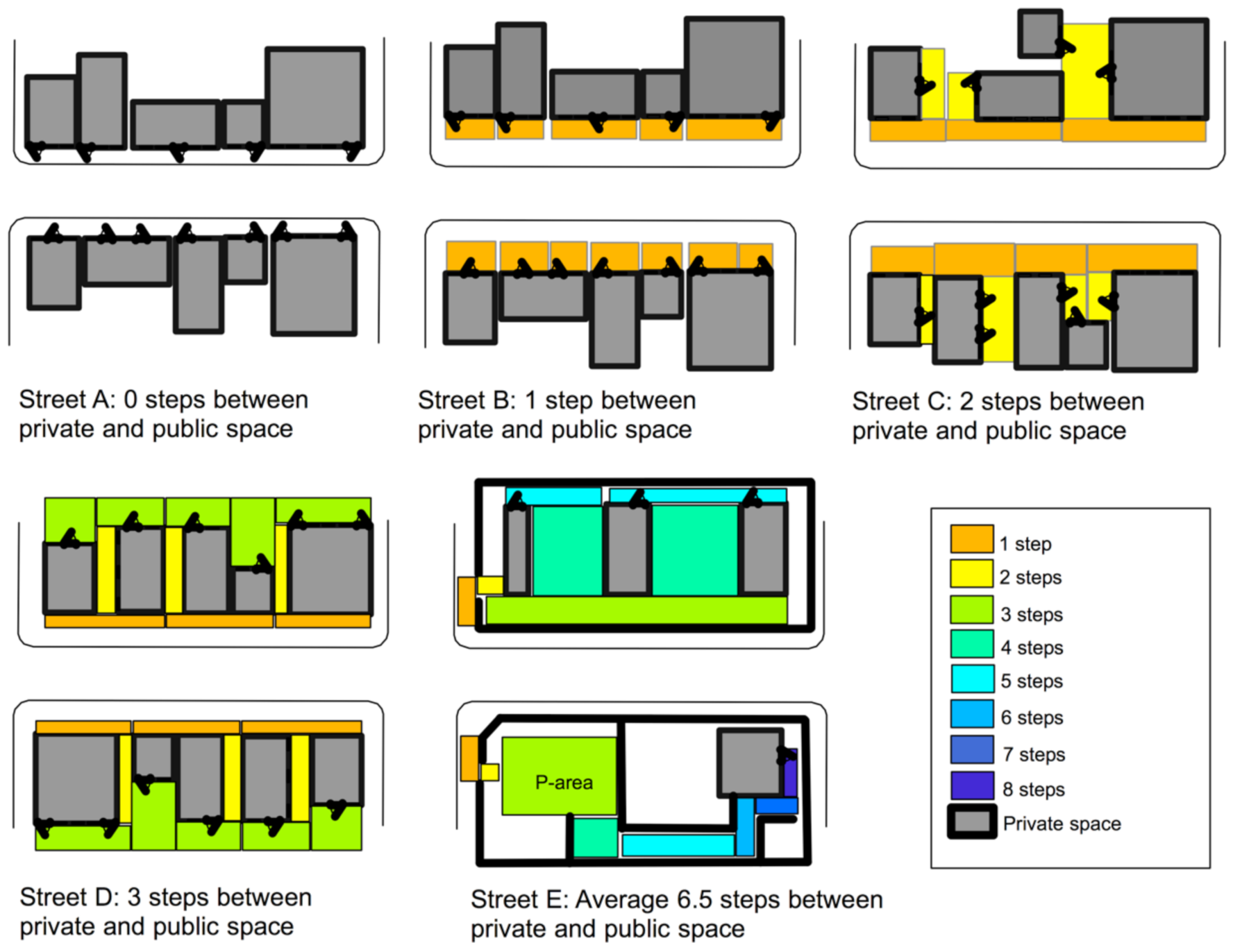
Later on, urban micro scale tools were developed by van Nes and López in a research project on space and crime in urban areas [32]. These micro scale tools are able to analyse the spatial relationships between private spaces inside buildings and the public streets. In the past, most space syntax research was conducted on either the spatial arrangements inside buildings or on neighbourhoods, city or metropolitan levels. The micro scale tools consist in to quantify to what extend a street segment is constituted by entrances with windows or not from adjacent buildings, to what extend adjacent buildings of a street segment have intervisible entrances with windows on ground floor level, and the number of semi-public spaces between the street and the private space inside buildings.
Figure 1 shows five different street segments with five different entrance situations. For each direction change in a semi-public or semi-private space, a topological step is taken. Often, after two topological steps, there is a lack of visibility from buildings towards the streets.
As the application of these tools in research has shown, the more direct the spatial accessibility and visibility is between buildings and streets, the more the streets are perceived to be safe [33], gender-balanced [21,23], and to enhance walkability [34]. Moreover, the lower the spatial integration of the street network, the more building entrances with windows on ground floor level are turned away from the street [32].
4. Results from the Spatial Analyses
Three aspects of spatial configuration can provide an understanding of lively urban areas and illustrate the configurational inequalities responsible for attractional inequalities in an urban street network: to-movement and through-movement potentials of the street and road network and the private–public interface of buildings. The next sub-sections will discuss these aspects more precisely in light of the question of urban compactness and urban vitality.
4.1. Spatial to-Movement & through-Movement Potentials and Their Influences on Economic Vital Urban Centres and Sustainable Mobility Means
If urban compactness consists of encouraging the location of a large variation of economic activities in city centres with short walking distances, the aim must then be to understand where the most optimal location is for shops and retail locations along a built environment’s street and road network. Research carried out by various space syntax researchers has shown the following results in line with the theory of the natural movement economic process: First of all, shops locate themselves in streets where most people move [29,35,36,37]. Evidently, shops tend to become attractors for people’s urban movement. Attractors and movement may influence each other, but they do not influence the spatial configuration of the urban street network. On the other hand, the street network seems to influence movement and attractors. The dispersal of global and local integration and connectivity is decisive [27] (p. 61). The next step is to identify the spatial properties of the street and road network that encourage sustainable mobility means or the opposite.
Figure 2 shows a global and local spatial integration analyses of Oslo’s street and road network. Here the degree of spatial integration is calculated in terms of the total number of direction changes from all streets to all others. The red and orange lines show the streets with the fewest total number of direction changes to all others, thus they are the spatially highest integrated streets. Global spatial integration indicates where the globally most integrated roads or streets are located in a city on a macro scale. In the case of Oslo, the most integrated roads are located on the outer ring road. At every junction, car-based shopping malls are located.
When calculating how integrated each street is within three times direction changes, the local integration can thus be calculated. Local integration indicates the various vital local pedestrian-based centres. In the case of Oslo, the pedestrian-based shopping areas are situated along the locally most integrated streets, while the car-based shopping centres are situated along the junctions of the globally most integrated streets [35] (p. 211). As the local integration analyses of Oslo show, a large number of direct connections from a shopping street to its vicinity within a short metrical distance influence the degree of walkability.
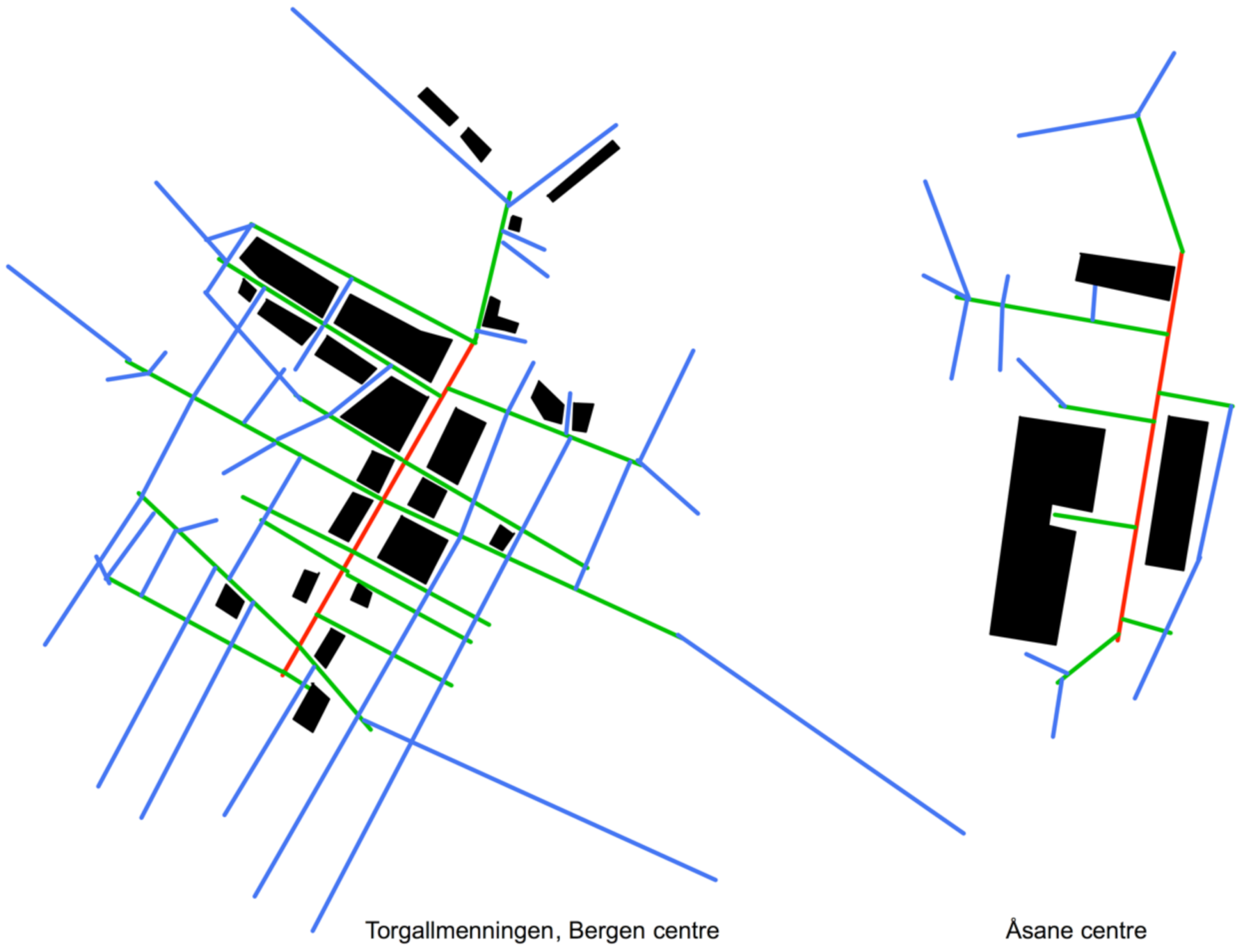
Figure 3 illustrates an example of two steps analyses for two different types of shopping streets in Bergen. The two steps analyses illustrate the degree of accessibility two direction changes away from a particular street. The image of the left shows the local catchment area of the shopping street Torgallmenningen in Bergen and the car-based shopping centre, Åsane, a suburb of Bergen. Most of the customers in Torgallmenningen do their shopping on foot, by bike or public transport, whereas a large number of customers in Åsane use a car. In comparison with Åsane, Torgallmenningen has a high density of the street network within a short metrical radius from the shopping street. The results are in line with earlier space syntax research. The more compact the lines are within a short metrical distance from the shopping street, the more attractive the shopping street is for pedestrians [33].
How can a street network’s spatial configuration influence how people move on foot or by car? High local spatial integration conditions the location of successful pedestrian-based shopping areas. It often is indicated by a dense structure on the street network within a short metrical distance in the vicinity of a shopping street. Shops have a linear location pattern along the most locally integrated streets, while they tend to be clustered at the junctions of the most globally integrated roads where the local integration is low. Thus, indication of a successful vital shopping and retail area which is pedestrian-based requires a strong local and global position in an urban street and road network. If urban growth changes the integrated core, either on a local or a global scale, the optimal location for profit maximising is affected.
In order to survive in a competitive environment, shop and retail owners will always search for the optimal location to reach potential customers. Thus, creating a vital city centre and sub-centres calls for an account of their global and local location in an urban street network and the respective degrees of connectivity to their vicinity. High density of the street network within a short metrical radius encourages human movement on foot. A globally integrated street network with poor connections to its vicinity and low density of the street network within a short metrical radius encourages private car use.
Recently, the angular weighting between street segment and metrical radius has been added into space syntax analyses [38]. Two types of refined space syntax analyses have emerged through testing on pedestrian flow data and the location of economic activities—to-movement and through-movement potentials. The angular segment integration analyses show the to-movement potentials and the results have similarities with the classic axial integration analyses discussed in Figure 2. Obviously, shops locate themselves along the highest spatially integrated streets, on different scale levels [14,35,36,37]. The angular choice analyses show the through-movement potentials on various scale levels. The results correlate with the flow of pedestrian and vehicle transport movement [38].
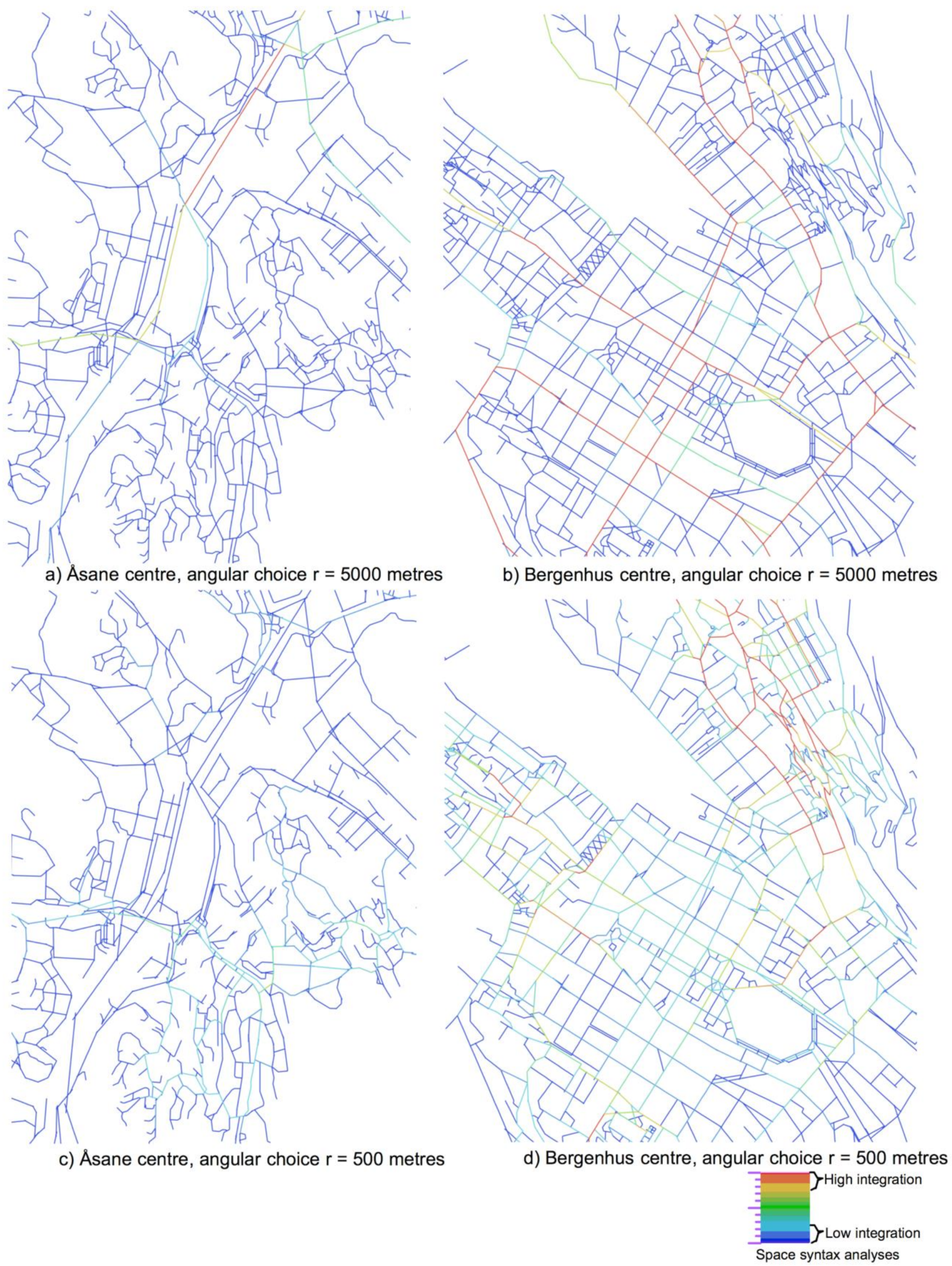
Figure 4 shows an angular choice analysis of the two different areas in Bergen surrounding the shopping streets analysed in Figure 3 with a radius of 5000 (top) and 500 (bottom) m. The analysis with the low metric radius indicates the through movement potentials for pedestrians, whereas the high metric radius indicates the through movement potentials for cars and bicycles. Bergen has two modern and one historic shopping centre. Åsane was a separate municipality that became a part of Bergen municipality in 1972. During the last 50 years, Åsane has offered space for providing housing for the population growth in Bergen [20]. The current centre of Åsane contains one of Bergen’s two large car-based shopping malls. The historic shopping area in Bergen centre, named Bergenhus, is located on the peninsula between seven mountains. The current street pattern dates back to the end of 1700, after some large city fires.
The streets in the historic centre have high values (coloured in red and yellow) in the analyses with a radius of 500 m. An integrated main route runs through the centre with the radius of 5000 m. Mostly public transport busses are using this integrated main route. The historic city centre is very popular for shopping on foot. Conversely, the values of the streets are low in the analyses with the 500 m radius in the modern shopping centre, whereas it is high in the analysis with the 5000 m radius. This modern shopping centre in Åsane enhances private cars usage. The shopping centre is surrounded by parking lots for cars. At present, strategic plans are made for making a light rail connection between Bergen centre and Åsane centre. However, plans are missing for improving the walkability conditions in the vicinity of the proposed new light rail stops.
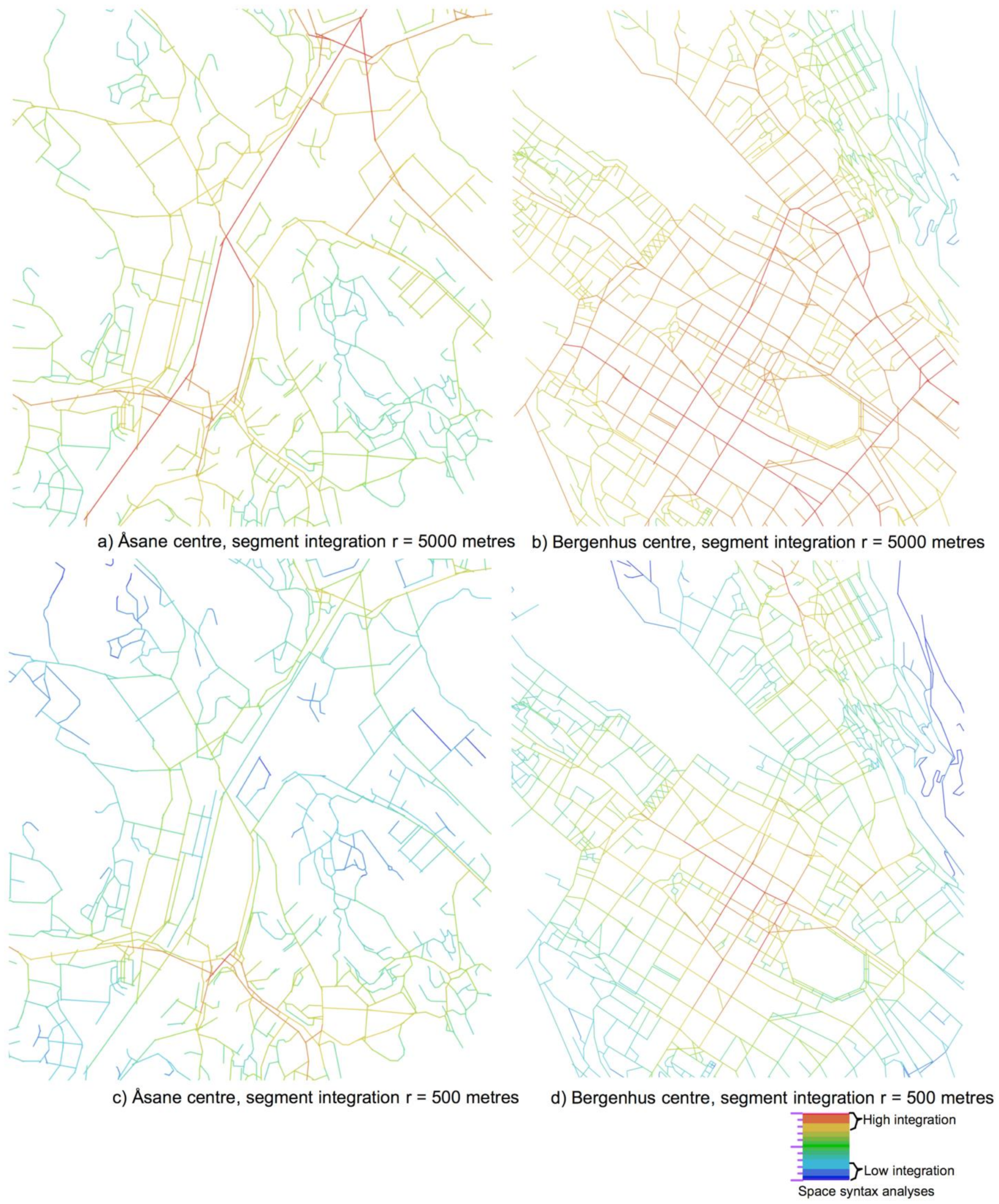
Figure 5 shows a segment integration analysis of the same shopping centres in Bergen with a radius of 5000 (a, b) and 500 (c, d) m. The small metric radius indicates the to-movement potentials for pedestrians, whereas the large metric radius indicates the to-movement potentials for cars and bicycles. As can be seen, the modern shopping centre has the highest to-movement potentials on a city scale, whereas the historic city centre has the highest to-movement potentials on a local scale. As the results of both the angular choice and segment analyses show, the vicinity of the modern shopping centre has a street network configuration that is less attractive for pedestrians.
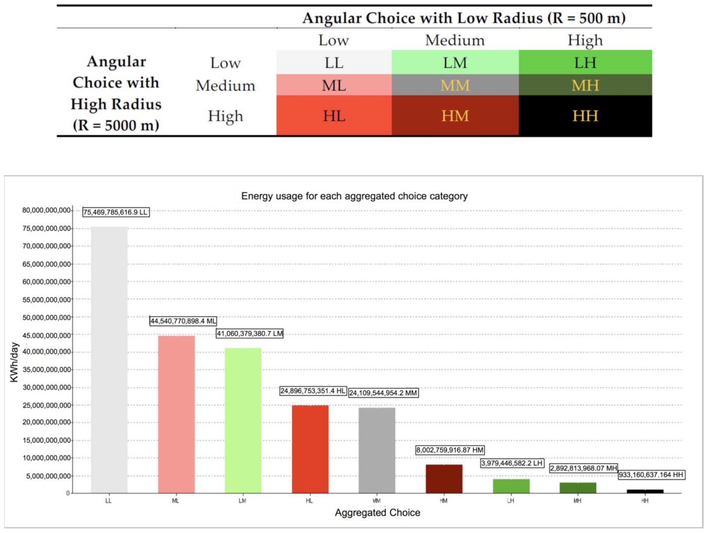
The angular choice analysis is applied in a research project on space and energy use for transport in Bergen and Zürich [5]. Here the angular choice analyses with a low and with a high metrical radius are applied. In other words, here we measure how integrated the various main routes are in terms of the fewest angular deviations within a radius of 500 m or 5000 m. As the results show, neighbourhoods with high values on the angular choice analyses with both a high (5000 m) and a low (500 m) metrical radius have low energy use for transport. The public transport lines tend to be located on the angular integrated main routes running through locally integrated neighbourhoods. The degree of walkability is high. Conversely, neighbourhoods with low values on the angular choice analyses with both a high and a low metrical radius have high energy use for transport [6].
Figure 6 shows a bar chart with a juxtaposition of the angular choice analyses with energy use for transport for Bergen. Here the numerical values from the angular choice analyses are juxtaposed with the energy data for transport. The higher the local angular choice integration values, the greater the degree of walkability [34]. As Jane Jacobs presumes, short urban blocks enhance short walking routes [7]. The same results on spatial configuration and energy use for transport are found in Zürich, too. Thus, the spatial structure of the street and road network on a local scale matters for understanding to what extent people use sustainable mobility means or not.
Seemingly, a well-integrated street network on a local scale within a short metrical distance enhances walkability. In addition, a highly integrated main route running through local areas with high local integration enhances the location of public transport means, because the walking distances to these lines tend to be short and easily orientable.
4.2. The Building–Street Interface and its Influence on Street Safety and Vitality in Urban Areas
As Rogers [8], Jacobs [15] and Calthorpe [11] suggest, one of the aims of repopulating city centres is to provide safe central areas where streets are free from anti-social behaviour. As mentioned earlier, neighbourhoods with a highly integrated street network on a local scale enhance walkability. However, if the streets lack intervisibility from adjacent buildings, people tend to avoid being in the streets and the streets are perceived to be unsafe [21,23,39].
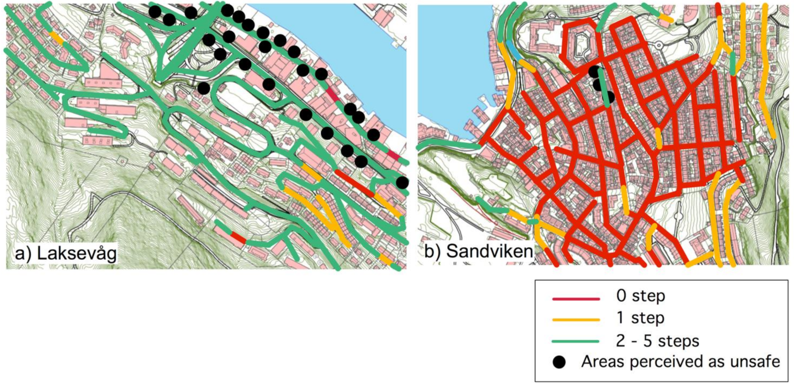
The topological relationship between private and public space matters for the perception of street safety in terms of eyes on the streets from adjacent buildings and the possibilities for social interaction between people on street and people inside buildings. Figure 7 shows a topological depth between private and public space analyses of two different neighbourhoods close to the city centre in Bergen, Norway. The black dots are areas pointed out by 200 respondents as ‘dodgy’ and perceived unsafe places [33]. In the Laksevåg neighbourhood, most of the streets have adjacent buildings that are turned away from them. The area is often perceived as unsafe to walk through. Conversely, in the Sandviken neighbourhood, most buildings have their entrances with windows located on ground floor level oriented towards the streets. The area is perceived to be lively and safe. Families with children prefer to live in this neighbourhood [20,40].
In a research project on space and crime, the position of building entrances influences also the risk of burglary, the perception of safety, the presence of women in streets, and sexual harassment rates. The more that building entrances are turned away from streets, the higher the risk of burglary [32], the streets are perceived to be unsafe [33], women avoid frequenting these streets [21], and the higher the risk of sexual harassment [23]. The design of urban space can thus affect the perception of safety and the use of space. This issue seems to touch upon the problem of architectural determinism. However, whether crime or social malaise will occur in spatially segregated areas with a lack of active building frontages or not naturally depends on the behaviour of their inhabitants and the local cultural context [14]. A space syntax approach, on the other hand, can identify the spatial features of the areas that have a high level of crime and social misuse. As research has shown so far, the means of a built environment are physical while its ends are functional—not vice versa as argued in many publications on the built environment [28].
4.3. Identifying Urban Compactness through Spatial Configurations
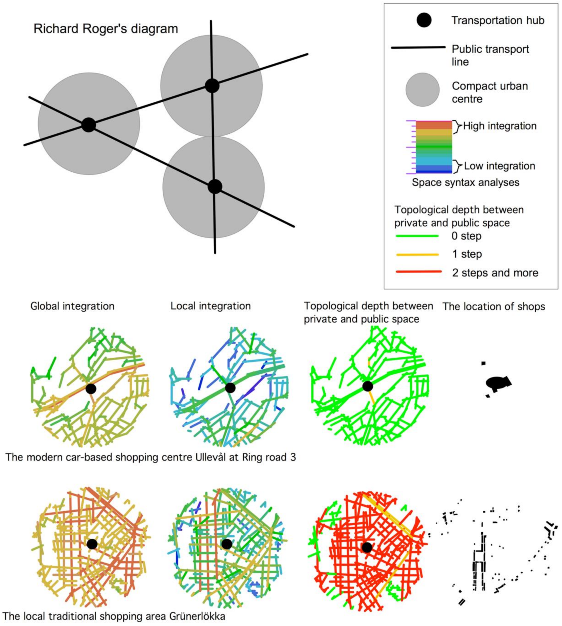
The following examples will demonstrate how the spatial features of a compact city can be described with a spatial configurative approach. Here again, we use Oslo as an example. Figure 8 (above) shows Rogers’ diagram where he tries to illustrate or clarify the relationship between a compact city centre and its compact sub-centres [8] (p. 53). The darkest colours indicate high density or high urban compactness. In what way these centres are compact is not clear. This diagram has much in common with Christaller’s model [41], proposed in the 1930s regarding the relationship between city centre and sub-centres. Models of this kind are often used in various policy and strategic planning documents. However, the finer spatial content inside the circles is missing. It does not say how these centres can function spatially, socially and economically in a sustainable manner. Likewise, a concise understanding of the way each centre relates to their surrounding areas and the whole city is lacking. In general, the fine-grained street network and its interconnectivity are not taken into consideration at all.
From a space syntax approach, Figure 8 (below) shows the results from the space syntax analyses of the street network of one car- and one pedestrian-based shopping area in Oslo within a radius of 1 km. Three scale levels are used—global integration addresses the city level, local integration for the neighbourhood level, and the topological depth between private and public space addresses the street-building level.
Both centres have high global integration values, whereas the car-based shopping centre has low local integration values. The pedestrian-based shopping area has high local integration, whereas it is low in the car-based shopping centre. The short urban blocks and the orthogonal street network in Grünerløkka contribute to these high local integration values. Regarding the spatial relationship between streets and adjacent buildings, most buildings in the vicinity are turned away from the street in the car-based shopping centre. Conversely, most buildings have entrances with windows on ground floor level oriented towards the streets in the pedestrian-based shopping area.
As the results from the spatial analyses on various scale levels indicate, most shops are clustered in a shopping mall in the car-based shopping area, whereas the shops have a linear location pattern located along the highest locally integrated streets in the pedestrian-based shopping area. Moreover, the Grünerløkka also has a large number of cafés and restaurants. These findings are in line with the theory of the natural movement economic process. However, pedestrian-based shopping areas depend on high local integration. City centres with low local integration and high global integration enhance car-based shopping malls.
On a micro scale, streets with building entrances and windows located directly towards streets enhance ‘eyes on the streets’, and thus have a high level of perceived safety and walkability. Conversely, streets where the buildings are turned away from streets enhance private car usage. Often, dwellers living close to the Ullevål shopping centre tend to use their car for the daily shopping, whereas dwellers in the Grünerløkka do their shopping on foot. The same accounts for Åsane and Bergenhus centres.
Most traditional urban shopping areas tend to obtain a dense street network within short metric distances. Moreover, often a high number of adjacent buildings tend to have windows and doors facing the streets. Seemingly, these spatial features are present in urban areas that are defined to be compact and sustainable. Conversely, most car-based shopping centres tend to have low local integration and low density of the street network. This does not encourage movement by foot. In addition, most buildings inside these areas are turned away from the streets, in terms of complex entrance situations and lack of windows on the ground floor. Urban areas with these kinds of spatial features do not enhance walkability and encourage private car usage [40,42,43].
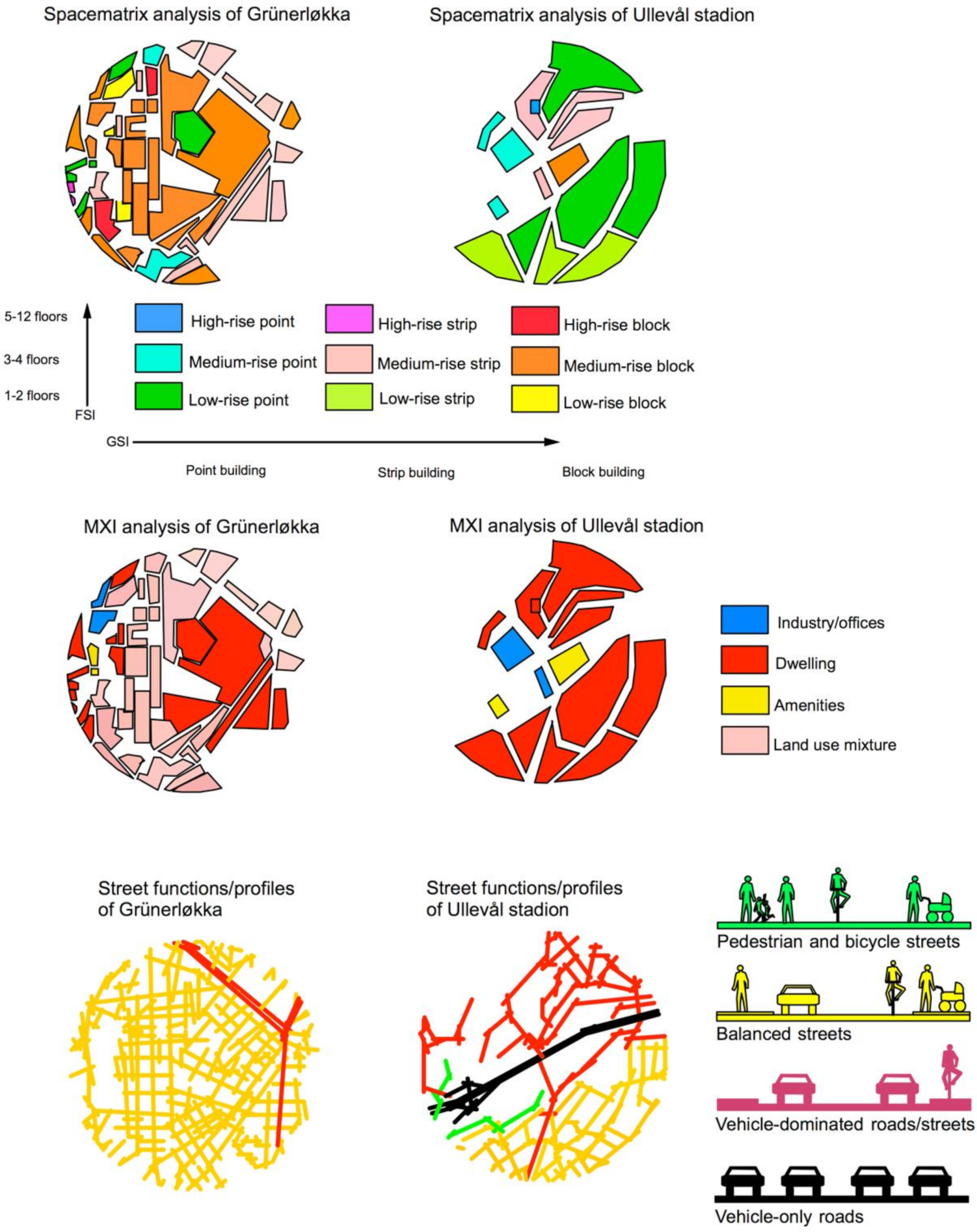
In order to add properties related to building density and land use diversity into Roger’s grey circles, spacematrix, function mixture (MXI) and street functions/profiles analyses methods were applied to Ullevål and Grünerløkka centres. Figure 9 shows the results of these analyses. The spacematrix analysis, originally developed by Johan Rådberg, is a method for quantifying buildings shapes based on correlating floor space index (FSI) with ground space index (GSI). The resolution of the urban blocks is used in the spacematrix analysis [10]. The MXI analysis consists of registering the percent of three main categories of land uses of buildings on the urban block resolution level. The categories for the functions are roughly divided into dwellings, working places and amenities [44]. In line with the theory of the natural urban transformation process, the degree of density and land use diversity depend on the spatial configuration of the street network [18,19]. The street function/profiles consist of classifying the street profiles in the following four groups: pedestrian and bicycles only streets, balanced streets, vehicle dominated roads and highways and vehicle only roads. The balanced streets tend to contain building entrances, and are found in most pre-War urban areas [44].
Ullevål has a low density of buildings and the area is mainly mono-functional, implying large travel distances between the various urban functions. Most building entrances are turned away from the streets, which reduces the attractiveness of walking as transportation mode. The area mostly consists of car-dominated roads, and the shopping centre is surrounded by parking lots. Conversely, Grünerløkka has high building density and a high degree of land use mixture of the buildings. That implies short and safe walking distances between various urban functions, supported by a highly integrated street network with buildings with doors and windows connected directly to the streets. Most streets in Grünerløkka have a balanced street profile. At present, Grünerløkka has become an attractive area for dwelling, to invest in, and to enjoy the urban street life. The findings are in line with the theory of the natural urban transformation process, where the street network configuration influences the degree of building density and land use diversity [19].
5. Conclusions: Spatial Conditions for Generating Walkability Potentials
How can these findings on street network integration, through-movement potentials and the building–street interface provide an understanding of urban compactness related to walkability potentials? Since the industrial revolution we have seen how comprehensive technical inventions affect the spatial structure of built environments and conversely its spatial product has affected social and economic behaviour. People are able to change their built environment and have purposes and intentions to do so. It is not always clear what the intentions are, but those concerning economic activities strive for profit maximising [14]. With the aim of creating urban areas and developing them in a sustainable way, we cannot ignore the behaviour of producers and consumers and the way the built environment influences them. However, the various spatial micro as well as macro scale conditions seems to affect the perception of safety regarding walking as transportation mode, in particular for women [23,42,43,45]. As research has shown, perceived unsafe streets encourage private car usage as a transportation mode [45].
From a spatial configurative point of view, understanding how urban compactness can affect walkability potentials depends on an account of the geometrical and topological structure of its street and road network and the topological relation between private and public spaces. Thus, a highly integrated street network on various scale levels is a sufficient condition for the location of economic activities. Likewise, a highly integrated street network with high angular choice values with both high and low metrical radii is a sufficient condition for high sustainable through-movement potentials in terms of high degrees of walkability.
High density of streets and their interconnectivity within a short metrical radius contributes to vital urban centres and dwelling areas. It is not enough to encourage high density of building volumes in neighbourhoods for reducing energy use for transport and encouraging walking. It is the density of the street network and its local and global position in the whole system that are the drivers for a natural urban transformation process towards a dense and multifunctional compact city. The same accounts for the degree of street–building interface on a building’s ground floor for making streets perceived to be safe for walking [23,43,45]. Lively well-functioning urban areas with a high density of buildings seem to be a by-product of the density of the urban street network, the dispersal of integration values on it [19], and short topological connections between private and public space [33,39,40].
My approach to the question of urban sustainability from a topological approach consists of a conceptual application of a spatial configurative approach to the compact city debate. What are the results? Is a compact city a necessary or sufficient condition for enhancing walkability? Here we need to break up the spatial parameters to several elements where each of them is one condition. von Wright operates with a complex set of sufficient or necessary conditions [3]. The findings from the space syntax analyses show that attractive walkable built environments need a complex set of sufficient conditions. The aim is to identify all these conditions for that to become possible. The complex set of necessary conditions can only be used for explaining how one spatial change, whether it is a road blockage or a new road link, changes the spatial configuration of a street network. It is enough that only one of the condition is present for that a change in the spatial variables occur [14].
If a compact city is conceived of as having a dense, well-connected street network, both on a local and metropolitan scale, and high intervisibility between buildings and streets, then urban compactness of this kind is a complex set of sufficient conditions for generating sustainable urban processes in terms of low energy use for transport. All these spatial parameters must be present for enhancing street safety and street life, in which enhance walkability. If a street has a high level of spatial integration but all buildings have their entrances and windows on ground floor level turned away from streets, the degree of walkability and perception of street safety will be affected. Blind walls and buildings turned away from streets are perceived to be unsafe and enhance avoidance. Thus, making attractive walkable cities requires more than making traffic safe and walking comfortable surfaces on pathways, pavements and sidewalks. The underlying drivers are the spatial configurative parameters which again contributes to a compact multifunctional urban neighbourhood, attractive for walking the last kilometre to and from public transport stops.
The challenge for further research is to build up a systematic empirical database for identifying all the spatial and physical conditions for shaping the opportunities for enhancing walkability. In particular, systematic registrations of people in streets at different time periods needs to be conducted for different types of urban centres. In addition, various cultural aspects, traditions, planning and organisational constraints need to be added into the research. In some cultures, planning cities for facilitating private car ownership is perceived as a part of the modernisation process, whereas in other cultures, the focus is now on pedestrianising the streets in city centres. Research of this kind requires context-dependent cases, where the aim is to understand the necessary conditions as to why something became possible for each specific case. At present, recent political decisions for making the three dense urban centres of Oslo car-free has been a necessary condition for improving the streetscapes of these centres. The current spatial conditions in these three highly locally integrated historic urban centres function as a complex set of sufficient conditions for enhancing walkability, and provide the suitable spatial framework for an easy implementation of these policies.
Seemingly, the spatial structure of the street network on various scale levels matters for achieving some of the United Nations’ sustainable development goals. Reduced energy use for transport touches upon parts from goal 7 (affordable and green energy) and goal 11 (sustainable cities and communities). Walkability touches upon parts from goal 11 and 3 (good health and well-being). Streets enhancing gender balance touches upon goal 5 (gender equality), whereas safe streets and possibilities for microeconomic activities touches upon goal 11. Compared with many other accounts of urban sustainability, a space syntax approach can offer specific concepts of spatial and functional aspects to explain or understand compact cities and their effects on economic and social behaviour—whether it turns out to enhance walkability or not.
Funding
This research received no external funding.
Institutional Review Board Statement
Not applicable.
Informed Consent Statement
Not applicable.
Data Availability Statement
Not applicable.
Conflicts of Interest
The authors declare no conflict of interest.
References
- United Nations (UN). Resolution Adopted by the General Assembly on 6 July 2017; A/RES/71/313; Seventy-First Session, NY, USA. 2017. Available online: https://undocs.org/A/RES/71/313 (accessed on 15 February 2021).
- Maiullari, D.; Mosteiro-Romero, M.; De Koning, R.E.; Van Timmeren, A.; Van Nes, A.; Schlüter, A. SPACERGY: Space-Energy Patterns for Smart Energy Infrastructures, Community Reciprocities and Related Governance; BK Books; TU-Delft: Delft, The Netherlands, 2019. [Google Scholar]
- Von Wright, G.H. Explanation and Understanding; Lowe & Brydone Ltd.: London, UK, 1971. [Google Scholar]
- Patermann, C. Sustainable Development in European Cities: How Research can Contribute. Available online: http://ess.co.at/SUTRA/susurbdev.html (accessed on 15 January 2021).
- The Brundland Commission. Our Common Future. World Commission of Environment and Development. 1987. Available online: http://www.un-documents.net/wced-ocf.htm (accessed on 15 January 2021).
- De Koning, R.E.; Tan, W.; Van Nes, A. Assessing spatial configurations and transport energy usage for planning sustainable communities. Sustainability 2020, 12, 8146. [Google Scholar] [CrossRef]
- Jenks, M.; Burton, E.; Williams, K. The Compact City. A sustainable Urban Form? E & FN Spon: New York, NY, USA, 1996. [Google Scholar]
- Rogers, R. Towards an Urban Renaissance; Urban Task Force; E & FN Spon: New York, NY, USA, 1999. [Google Scholar]
- Salingaros, N. Principles of Urban Structure; Techne Press: Delft, The Netherlands, 2005. [Google Scholar]
- Rådberg, J. Towards a theory of sustainability and urban quality; A new method for typological urban classification. In Proceedings of the 14th Conference of the International Association for People-Environment Studies, Stockholm, Sweden, 30 July–3 August 1996; pp. 384–392. [Google Scholar]
- Calthorpe, P. The Next American Metropolis. Ecology, Community, and the American Dream; Princeton Architectural Press: New York, NY, USA, 1993. [Google Scholar]
- Carmona, M.; Heath, T.; Oc, T.; Tiesdel, S. Public Places-Urban Spaces; Routledge: London, UK, 2012. [Google Scholar]
- A new survey of universal knowledge. In Encyclopaedia Britannica; Sorde-Texti, W. (Ed.) Benton Publishers: Chicago, IL, USA, 1955; Volume 21. [Google Scholar]
- Van Nes, A.; Yamu, C. Exploring challenges in space syntax theory building: The use of positivist and hermeneutic explanatory models. Sustainability 2020, 12, 7133. [Google Scholar] [CrossRef]
- Jacobs, J. The Death and Life of Great American Cities; Pimlico: London, UK, 2000. [Google Scholar]
- Alexander, C. A city Is Not a Tree; In Design Magazine, no; Routledge: London, UK, 1966; Volume 206, pp. 46–55. [Google Scholar]
- Marshall, S. Streets and Pattern; Spon Press: Oxon, UK, 2005. [Google Scholar]
- Van Nes, A.; Berghauser Pont, M.; Mashhoodi, B. Combination of space syntax with spacematrix and the mixed use index. In Proceedings of the 8th International Space Syntax Symposium, Santiago, Chile, 3–6 January 2012. [Google Scholar]
- Ye, Y.; Van Nes, A. Quantitative tools in urban morphology: Combining space syntax, spacematrix and mixed-use index in a GIS framework. Urban Morphol. 2014, 18, 97–118. [Google Scholar]
- De Koning, R.E.; Roald, H.J.; Van Nes, A. A scientific approach to the densification debate in Bergen centre in Norway. Sustainability 2020, 12, 9178. [Google Scholar] [CrossRef]
- Van Nes, A.; De Rooij, L. The perceived safety and spatial behaviour in three different neighbourhoods in Rotterdam. In Proceedings of the 10th International Space Syntax Symposium, London, UK, 13–17 July 2015; pp. 139:1–139:19. [Google Scholar]
- Van Nes, A.; Aghabeik, L. Ethnic groups and spatial behaviour in Rotterdam’s neighbourhoods. In Proceedings of the 10th International Space Syntax Symposium, London, UK, 13–17 July 2015; pp. 102:1–102:17. [Google Scholar]
- Miranda, J.; Van Nes, A. Sexual violence in the city: Space, gender, and the occurrence of sexual violence in Rotterdam. Sustainability 2020, 12, 7609. [Google Scholar] [CrossRef]
- Hillier, B. Space as Paradigm for understanding strongly relation systems. In Proceedings of the Space Syntax, 2nd International Symposium, Brazilia, Brazil, 29 March–2 April 1999. [Google Scholar]
- Hillier, B. The theory of the city as object or how spatial laws mediate the social construction of urban space. In Proceedings of the Space Syntax, 3rd International Symposium, Atlanta, GA, USA, 7–11 May 2001; Peponis, J., Wineman, J., Bafna, S., Eds.; Georgia Tech: Atlanta, GA, USA. [Google Scholar]
- Hillier, B.; Penn, A.; Hanson, J.; Grajewski, T.; Xu, J. Natural movement: Or, configuration and attraction in urban pedestrian movement. Environ. Plan. B 1993, 20, 29–66. [Google Scholar] [CrossRef] [Green Version]
- Penn, A.; Hillier, B.; Banister, D.; Xu, J. Configurational modelling of urban movement networks. Environ. Plan. B 1998, 25, 59–84. [Google Scholar] [CrossRef] [Green Version]
- Hillier, B. Space Is the Machine; Cambridge University Press: Cambridge, UK, 1996. [Google Scholar]
- Van Nes, A. The impact of the ring road on the location pattern of shops in town and city centres. A space syntax approach. Sustainability 2021, 13, 3927. [Google Scholar] [CrossRef]
- Yamu, C.; Van Nes, A.; Garau, C. Bill hillier’s legacy: Space syntax—A synopsis of basic concepts, measures, and empirical application. Sustainability 2021, 13, 3394. [Google Scholar] [CrossRef]
- Rashid, M. The Geometry of Urban Layouts; Springer: Berlin/Heidelberg, Germany, 2017. [Google Scholar]
- Van Nes, A.; López, M. Macro and micro scale spatial variables and the distribution of residential burglaries and theft from cars: An investigation of space and crime in the Dutch cities of Alkmaar and Gouda. J. Space Syntax. 2010, 1, 314. [Google Scholar]
- Rønneberg Nordhov, N.A.; Weebe Ritland, P.; Larsen, A.; Van Nes, A. The role of building entrances towards streets and the perception of safety in six neighbourhoods in Bergen. In Proceedings of the 12th International Space Syntax Symposium, Beijing, China, 8–12 July 2019. [Google Scholar]
- De Koning, R.E.; Van Nes, A. Urban space and energy usage. In Proceedings of the 12th International Space Syntax Symposium, Beijing, China, 8–12 July 2019. [Google Scholar]
- Van Nes, A. Road Building and Urban Change. Ph.D. Thesis, Department of Land Use and Landscape Planning, Agricultural University of Norway, Ås, Norway, 27 September 2002. [Google Scholar]
- Van Nes, A. Typologies of shopping areas in Amsterdam. In Proceedings of the 5th International Space Syntax Symposium, Delft, The Netherlands, 13–17 June 2005; Techne Press, TU-Delft: Delft, The Netherlands, 2005. [Google Scholar]
- Van Nes, A. Centrality and development in the Rijnland region. In Proceedings of the 6th International Space Syntax Symposium, Istanbul, Turkey, 12–15 June 2007. [Google Scholar]
- Hillier, B.; Yang, T.; Turner, A. Normalising least angle choice in depthmap and how it opens up new perspectives on the global and local analysis of city space. J. Space Syntax. 2012, 3, 155–193. [Google Scholar]
- Van Nes, A.; Lopez, M. Spatial-socio classification of deprived neighbourhoods in the Netherlands. Strategies for neighbourhood revitalization. In Proceedings of the 9th International Space Syntax Symposium, Seoul, Korea, 31 October–3 November 2013. [Google Scholar]
- Meinert, M.; Thomassen, S.T.; Van Nes, A.; Roald, H.J.; Skovsgaard, T.L. How children use urban space in two different neighbourhoods in Bergen, Norway. In Proceedings of the 12th International Space Syntax Symposium, Beijing, China, 8–12 July 2019. [Google Scholar]
- Christaller, W. How I discovered the theory of central places: A report about the origin of central places. In Man Space and Environment; Mayfield, R.C., Ed.; Oxford University Press: Oxford, UK, 1972; pp. 601–610. [Google Scholar]
- Hidayati, I.; Yamu, C.; Tan, W. The emergence of mobility inequality in greater Jakarta, Indonesia: A socio-spatial analysis of path dependences in transport—Lan use policies. Sustainability 2019, 11, 5115. [Google Scholar] [CrossRef] [Green Version]
- Hidayati, I.; Yamu, C.; Tan, W. Realised pedestrian accessibility of an informal settlement in Jakarta, Indonesia. J. Urban. Int. Res. Placemaking Urban Sustain. 2020. [Google Scholar] [CrossRef]
- Van Nes, A.; Yamu, C. Introduction to Space Syntax in Urban Studies; Springer Nature: Berlin/Heidelberg, Germany, 2021; Forthcoming. [Google Scholar]
- Hidayati, I.; Tan, W.; Yamu, C. How gender differences and perceptions of safety shape urban mobility in Southeast Asia. Transp. Res. Part F Traffic Psychol. Behav. 2020, 73, 155–173. [Google Scholar] [CrossRef]
Figure 1.
The principles of quantifying the topological depth between private and public space.

Figure 2.
Global (a) and local (b) axial integration of Oslo. The car-based shopping centres are located at the junctions along the highest globally integrated streets (the black circles).
Figure 2.
Global (a) and local (b) axial integration of Oslo. The car-based shopping centres are located at the junctions along the highest globally integrated streets (the black circles).

Figure 3.
Two steps analyses of two different types of shopping streets in Bergen.

Figure 4.
Angular choice analyses of two different centres in Bergen with the two different types of shopping areas with radius like 5000 m (a,b) and radius like 500 m (c,d).
Figure 4.
Angular choice analyses of two different centres in Bergen with the two different types of shopping areas with radius like 5000 m (a,b) and radius like 500 m (c,d).

Figure 5.
Angular segment integration analyses of two different centres in Bergen with the two different types of shopping areas with radius like 5000 m (a,b) and radius like 500 m (c,d).
Figure 5.
Angular segment integration analyses of two different centres in Bergen with the two different types of shopping areas with radius like 5000 m (a,b) and radius like 500 m (c,d).

Figure 6.
The juxtaposition between aggregated choice (combination of choice with a high and low metrical radius) and energy use for transport for Bergen.
Figure 6.
The juxtaposition between aggregated choice (combination of choice with a high and low metrical radius) and energy use for transport for Bergen.

Figure 7.
Topological depth analysis between private and public space with registrations of areas that are perceived as unsafe for the Laksevåg (a) and the Sandviken (b) neighbourhoods of Bergen, Norway.
Figure 7.
Topological depth analysis between private and public space with registrations of areas that are perceived as unsafe for the Laksevåg (a) and the Sandviken (b) neighbourhoods of Bergen, Norway.

Figure 8.
Using space syntax to demonstrate urban compactness in the pedestrian- and car- based shopping areas in Oslo.
Figure 8.
Using space syntax to demonstrate urban compactness in the pedestrian- and car- based shopping areas in Oslo.

Figure 9.
Using spacematrix, function mixture (MXI) and street functions/profiles analyses to demonstrate urban compactness in Grünerløkka and Ullevål areas in Oslo.
Figure 9.
Using spacematrix, function mixture (MXI) and street functions/profiles analyses to demonstrate urban compactness in Grünerløkka and Ullevål areas in Oslo.

Publisher’s Note: MDPI stays neutral with regard to jurisdictional claims in published maps and institutional affiliations. |
© 2021 by the author. Licensee MDPI, Basel, Switzerland. This article is an open access article distributed under the terms and conditions of the Creative Commons Attribution (CC BY) license (https://creativecommons.org/licenses/by/4.0/).
Share and Cite
MDPI and ACS Style
van Nes, A. Spatial Configurations and Walkability Potentials. Measuring Urban Compactness with Space Syntax. Sustainability 2021, 13, 5785. https://0-doi-org.brum.beds.ac.uk/10.3390/su13115785
AMA Style
van Nes A. Spatial Configurations and Walkability Potentials. Measuring Urban Compactness with Space Syntax. Sustainability. 2021; 13(11):5785. https://0-doi-org.brum.beds.ac.uk/10.3390/su13115785
Chicago/Turabian Stylevan Nes, Akkelies. 2021. "Spatial Configurations and Walkability Potentials. Measuring Urban Compactness with Space Syntax" Sustainability 13, no. 11: 5785. https://0-doi-org.brum.beds.ac.uk/10.3390/su13115785
Note that from the first issue of 2016, this journal uses article numbers instead of page numbers. See further details here.