Article

Dilemma of Geoconservation of Monogenetic Volcanic Sites under Fast Urbanization and Infrastructure Developments with Special Relevance to the Auckland Volcanic Field, New Zealand

1
School of Agriculture and Environment, Massey University, Palmerston North 4442, New Zealand
2
Institute of Earth Physics and Space Science, 9400 Sopron, Hungary
3
The Geoconservation Trust Aotearoa, 52 Hukutaia Road, Ōpōtiki 3122, New Zealand
*
Author to whom correspondence should be addressed.
Sustainability 2021, 13(12), 6549; https://0-doi-org.brum.beds.ac.uk/10.3390/su13126549
Submission received: 5 May 2021 / Revised: 6 June 2021 / Accepted: 7 June 2021 / Published: 8 June 2021
(This article belongs to the Special Issue Urban Disaster Risk Reduction)

Abstract

:
Geoheritage is an important aspect in developing workable strategies for natural hazard resilience. This is reflected in the UNESCO IGCP Project (# 692. Geoheritage for Geohazard Resilience) that continues to successfully develop global awareness of the multifaced aspects of geoheritage research. Geohazards form a great variety of natural phenomena that should be properly identified, and their importance communicated to all levels of society. This is especially the case in urban areas such as Auckland. The largest socio-economic urban center in New Zealand, Auckland faces potential volcanic hazards as it sits on an active Quaternary monogenetic volcanic field. Individual volcanic geosites of young eruptive products are considered to form the foundation of community outreach demonstrating causes and consequences of volcanism associated volcanism. However, in recent decades, rapid urban development has increased demand for raw materials and encroached on natural sites which would be ideal for such outreach. The dramatic loss of volcanic geoheritage of Auckland is alarming. Here we demonstrate that abandoned quarry sites (e.g., Wiri Mountain) could be used as key locations to serve these goals. We contrast the reality that Auckland sites are underutilized and fast diminishing, with positive examples known from similar but older volcanic regions, such as the Mio/Pliocene Bakony–Balaton UNESCO Global Geopark in Hungary.

1. Introduction

Intracontinental monogenetic volcanic fields are the most common on-land manifestation of volcanism on Earth [1]. For centuries societies have utilized volcanic landforms for resources, resulting in modified landscapes. Recently, abandoned quarry sites have become significant geosites, often featuring exposed magmatic plumbing systems of monogenetic volcanoes, easily accessible, and ready to be visited and utilized as geosites for volcano geology and hazard education [2,3,4,5,6,7,8,9,10,11,12,13,14]. The UNESCO IGCP Project (# 692. Geoheritage for Geohazard Resilience) promotes sites allowing complex volcanic processes to be engaged with and visualized by laypeople and scientists alike [15,16,17,18]. Though a promising new avenue for protection and utilization of abandoned quarries, high rates of urbanization and increasing economic value of geological commodities seen as necessary for local economic and development needs may override geoconservation policies and in some cases result in overexploitation [2,19,20,21,22,23,24,25,26,27,28,29,30,31]. Here we provide demonstrative case studies from two monogenetic volcanic fields and highlight the paradoxical situation whereby in an intact condition their inner structure remains hidden, while the destructive practice of quarrying can reveal the succession of eruptive phases and their geological components. Therefore, a balance must be defined between excavation and preservation, and when quarrying ceases added value must be recognized by activating educational areas and recreational paths. In this work we demonstrate this paradox unfolding in real time in a rapidly growing urban environment almost perfectly coinciding with the areal extent of the Quaternary Auckland Volcanic Field, considered to be an active volcanic field.
Auckland city, the largest in New Zealand, is built on a still active basaltic monogenetic volcanic field: the Auckland Volcanic Field [32] (Figure 1). Fourteen significant scoria cones within the Auckland City metropolitan boundaries are managed by the Tūpuna Maunga o Tāmaki Makaurau Authority (https://www.maunga.nz/, accessed 1 June 2021). This is a co-management framework between Auckland Council and indigenous groups with cultural ties to the scoria cones. While we acknowledge cultural and historical importance of these sites as significant population centers prior to European settlement [33,34], the potential of these sites for engagement in a geological context is not made explicit. In comparison to other sites in wider Auckland, geological outcrops are limited, due to centuries of human modification [35]. The level of protection for cultural and archaeological sites through the Maunga Authority, in addition to aspirations for these sites to be designated as a World Heritage site, means this is unlikely to change, and we do not argue otherwise.
South of the Auckland City boundaries, rapid urbanization and industrialization since the mid-20th Century has seen no protection afforded to sites as culturally significant and once as spectacular as those within Auckland City [36]. Demand for extractable scoria has led to the physical degradation of cones, and in some cases destruction. Lack of meaningful geoconservation policies sees this continue into the present. Geological outcrops exposed by quarrying, showing the internal structure of a scoria volcano, are located at an industrial park (marked with black rectangle on Figure 1) in Wiri, South Auckland. We document threats facing these geosites monitored through several visits over two years.
In western Hungary, 100 years of quarrying has left a legacy of exposed outcrops at monogenetic volcanoes (Figure 2). Though the Bakony–Balaton UNESCO Global Geopark manages some abandoned quarries, locations outside the boundaries of the geopark are not afforded the same protection or level of conservation management [32,33,34]. We highlight this at a 100-year-old abandoned basalt quarry that may be brought back into production, placing pressure on local communities who value the geoheritage and other environmental values. These two sites demonstrate the need to develop “ethical” guidance on geoconservation of significant sites in an industrial and urban context.

2. Materials and Methods

Here we provide geological observations of volcanic geoheritage sites within the urban region of the city of Auckland, New Zealand. These sites are listed in geopreservation inventories and appeared in various form of reports and books arguing for their geoheritage values from a semiquantitative way [35,36,37,38]. We demonstrate the under-utilization of the abandoned or still operating raw material quarry sites, in contrast to another region with similar volcanic geoheritage values in Central Europe, where such quarry sites are widely used for geoeducation purposes and in many cases fall under strong Geoconservation policies, especially those located within a UNESCO Global Geopark. First, we demonstrate the geological aspects of monogenetic volcanic fields by defining their meaning, geological values, and potential role in geohazard resilience programs. We provide some narrative comparative data to show the similarities between the Quaternary Auckland Volcanic Field and the Plio-Pleistocene volcanic fields in the western Pannonian Basin in Hungary. After establishing the case to explore the geoeducation potential of these volcanic fields, we locate the key sites and analyze the current utilization of the preserved geoheritage values in the context of volcanic geology. Subsequently, we use GoogleEarth Pro historic satellite imagery to identify the degree of geoheritage site losses through the last 25 years in contrast to their volcanic geoheritage values. In addition to using the semiquantitative method to define the degree of geoheritage loss, we provide direct records of field visits in the last five years demonstrating rapid degradation of sites subject to rapid urbanization, in particular the southern territory of the greater Auckland area (Figure 1). In conclusion, we emphasize the potential for abandoned quarries to provide information that could greatly enhance the communities’ understanding of volcanic processes and their hazards within the framework of volcanic fields.

3. Results

The two volcanic fields we explore are typical monogenetic volcanic fields within intracontinental settings. The key aspect of monogenetic volcanism is short and single-phase eruptions through simple volcanic conduits that source magma usually directly from the deep mantle region [1,39]. In recent years, numerous works have targeted the diversity of monogenetic volcanism and demonstrated the great variety of processes, time, and space scales over which they operate. While some monogenetic volcanoes may display some complexity, even the most complex monogenetic structures are simpler and smaller in volume than a typical polygenetic volcano such as a strato- or caldera volcano. The “monogenetic” nature of volcanism and the common formation of monogenetic volcanic fields that may include up to thousands of small volcanoes pose difficulties in assessing volcanic hazards, especially uncertainty in predicting future events within a volcanic field. While many volcanic fields, particularly Quaternary, display some recognizable patterns in eruption history, an equally large number display ambiguity in spatial and temporal evolution. To overcome this problem, volcanic hazards of such active volcanic fields are often dealt with by analyzing the full eruption spectrum of volcanic eruption types over the life of the volcanic field [40,41,42,43,44,45]. Geoheritage of monogenetic volcanic fields provides an invaluable asset in facilitating geoeducation in resilience to volcanic hazards. A common problem in geoeducation in young volcanic fields is geosites may be intact and potentially active volcanic geoforms [46,47,48]. Geological features may tell a “story” about the processes forming those volcanoes that may be subject to a lack of accessibility. This could be overcome by a network of geosites (e.g., various level of geoparks) interlinked within a volcanic field or across different volcanic fields, thereby representing a potentially vast spectrum of time. We demonstrate here that a young monogenetic volcanic field such as the Auckland Volcanic Field can have strong links to eroded Plio-Pleistocene volcanic fields of similar geotectonic settings such as those in Central Europe [49].

3.1. Volcanic Geoheritage Values of Monogenetic Volcanic Fields

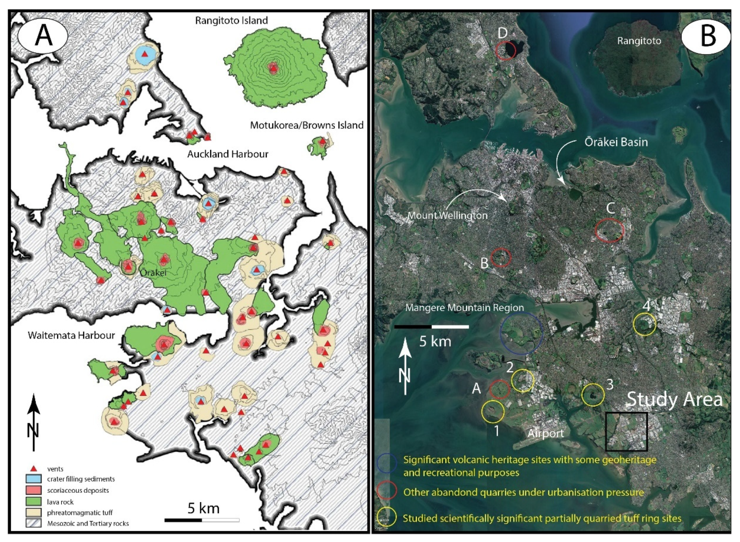
3.1.1. Auckland Volcanic Field

The Auckland Volcanic Field (AVF) is a Quaternary active monogenetic volcanic field that has at least 54 identified volcanic geoforms generated across a 250 ka time span [35,50,51]. The youngest eruptions took place from Rangitoto volcano, the largest volume eruptive center about 600 years ago (502+/−11; and 532+/−17 to 606+/−30), while the oldest known eruption measured date back to 260,000 +/−29,000 years from the Pupuke maar [51]. The eruption frequency shows that most of the eruptions took place in the 35 to 25 ky time-window [51]. Most of the volcanoes in this field commenced eruption with a brief explosive phreatomagmatic phase that formed a basalt tuff ring succession often capped by a magmatic unit of scoria and lava indicating the exhausted aquifers due to the progression of volcanic growth [52]. In the slightly elevated and central areas of the AVF which provided early settlement sites and the subsequent downtown area of Auckland, scoria cones are common (Figure 3A). These scoria cones are average in size, eruptive volume (e.g., Dense Rock Equivalent or DRE-~0.7–0.002 km3), and edifice geometry compared to other sites around the world [53] and served as important settlement sites for the indigenous Māori [54] (Figure 3A). In the present day, they are mostly protected as parks and recreational spaces well utilized by inhabitants of the city. However, they offer very little geologically unique aspects mostly due to the fact that they are grass covered with no exposures preserved or readily accessible [55,56,57]. In the southern part of the city, volcanoes are typically phreatomagmatic volcanoes, and explosion craters (shallow maars) surrounded by tuff rings are common [58]. A significant landmark in the region is Māngere Mountain (Te Pane o Mataoho), a complex elongated scoria and spatter cone complex with multiple craters (Figure 3B) associated with an extensive lava fields hosting some lave tubes. Māngere Mountain forms the basis of a recreational domain but also provides a unique example of geocultural aspects of scoria cones of the AVF and could be described as a “volcanic geology delight”. The volcano is the centerpiece of the Māngere Mountain Education Center (http://www.mangeremountain.co.nz/, accessed 1 June 2021), providing a study path and basic volcanic geology overviews for independent and group visitors, thereby playing an important role in geoeducation in the region (Figure 3C,D). Further south, in the low coastal plains of Auckland, monogenetic volcanoes display a dominant basal structure of a maar and tuff rings, with broad craters partially filled with lava lakes and scoria cone complexes, such as Maungataketake Mountain (Figure 3E). These locations are in a highly urbanized area of Auckland featuring large logistic centers, factories, and transportation hubs developed over the last decades. In fact, it is the geomorphology of this region known as the “Manukau Lowlands” that has made it ideal for rapid industrial expansion covering broad regions extending to the coast of the Manukau Harbor [59,60,61].
Currently, Auckland is undergoing rapid traditional sprawling suburbanization, bringing many negative effects and allowing little to no room for integration of ecosystem and geosystem services within the urban growth [61]. In addition, local development drives high demand for raw materials, resulting in significant modification of geosites, and in some cases outright destruction [54,62]. Some quarries continue to operate, while others have been repurposed as industrial and waste storage facilities for the fast-growing urban surrounds (Figure 3E). In the same region, volcanic geoheritage sites are also abundant, one of the most intact featuring an exposed cross section of tuff ring adjacent to a coastal exposure of ancient fossil forest with preserved tree trunks at Maungataketake [54,58] (Figure 3F,G). While these sites provide superb examples of eruptive products of a phreatomagmatic explosive eruption, the only locations where one could see into a monogenetic volcano interior are the already quarried sites. However, lack of public access and engagement with these sites, coupled with rapid urbanization and continued modification of sites risks permanent loss of geoeducation potential. Rapid urbanization of rural areas contiguous with the Auckland metropolis may also be in conflict with farming communities in rural south Auckland, which may also take place on landscapes with an important geological and cultural story to tell [63,64]. Based on our investigations, we recognize a need to reimagine Auckland as a complex multi-faceted ecosystem, underlain by a geoheritage and geoconservation framework which would sit at the center of a holistic and integrated conservation and urban development strategy [63,64].

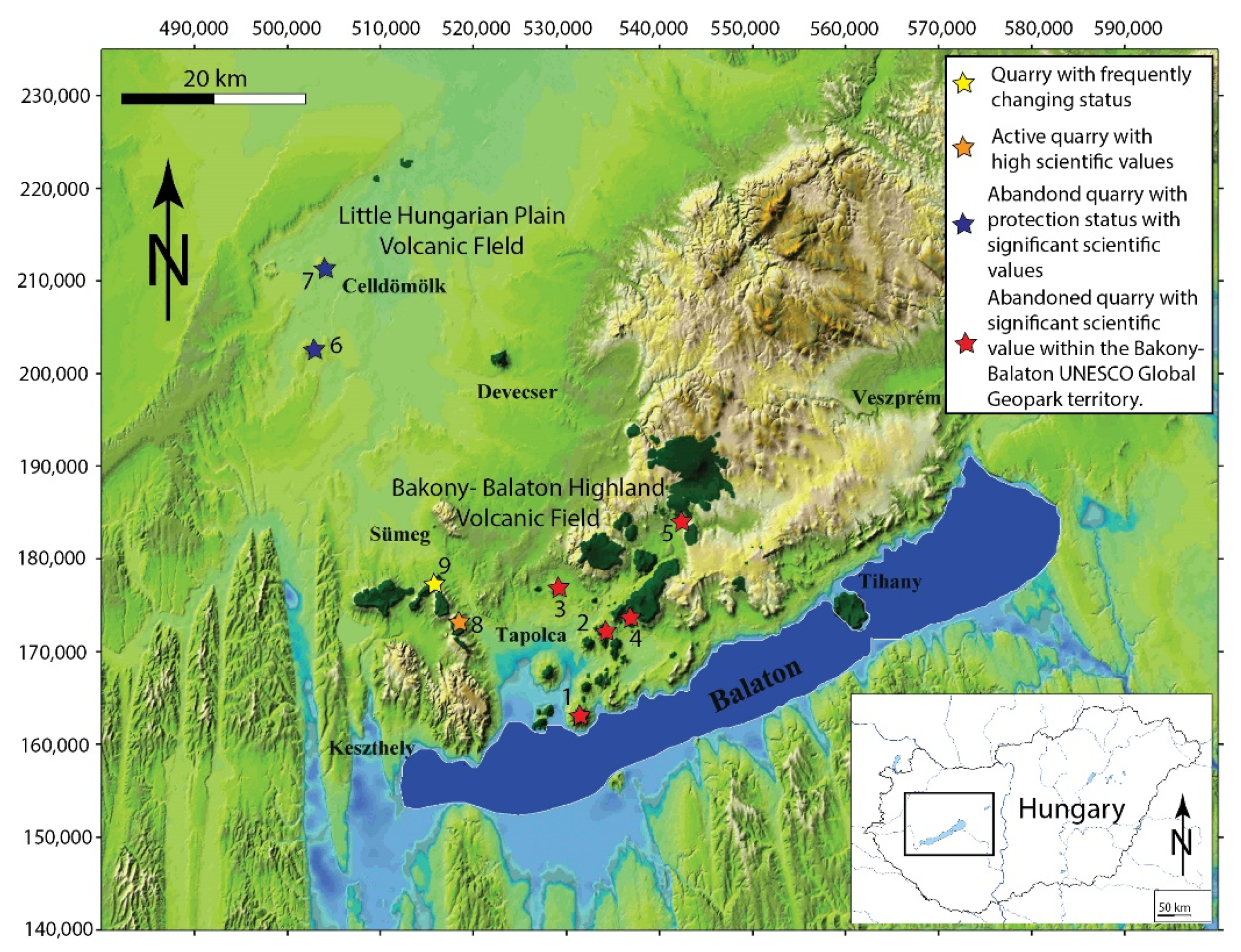
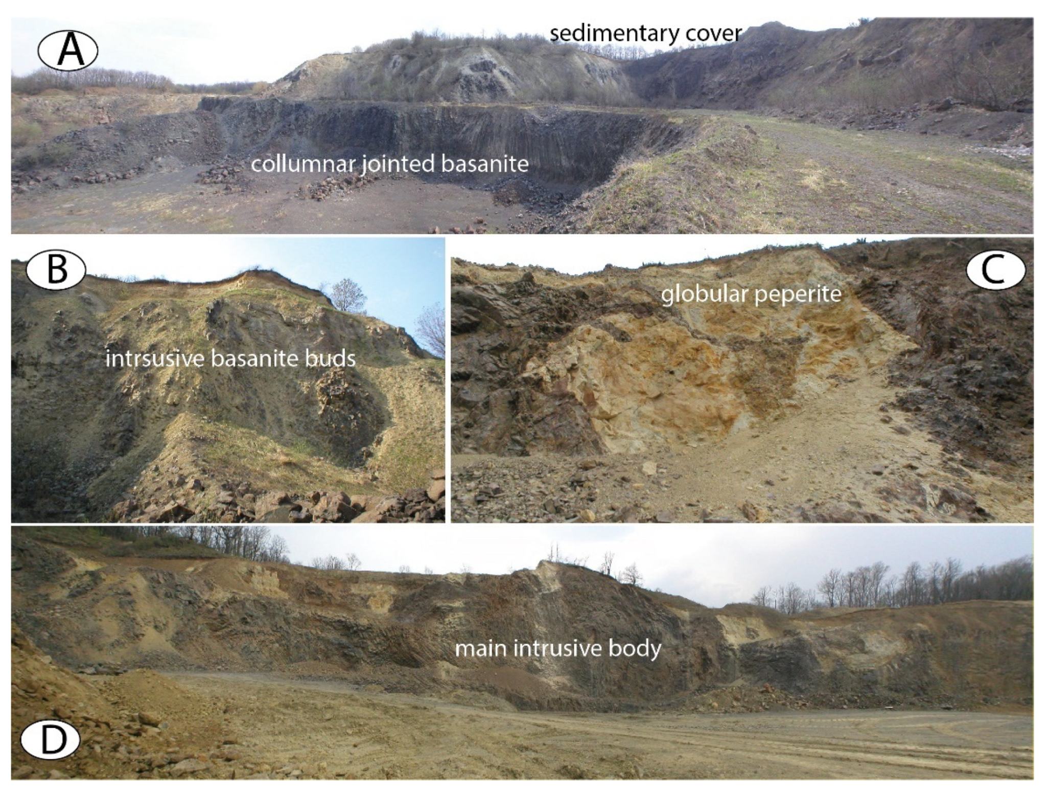
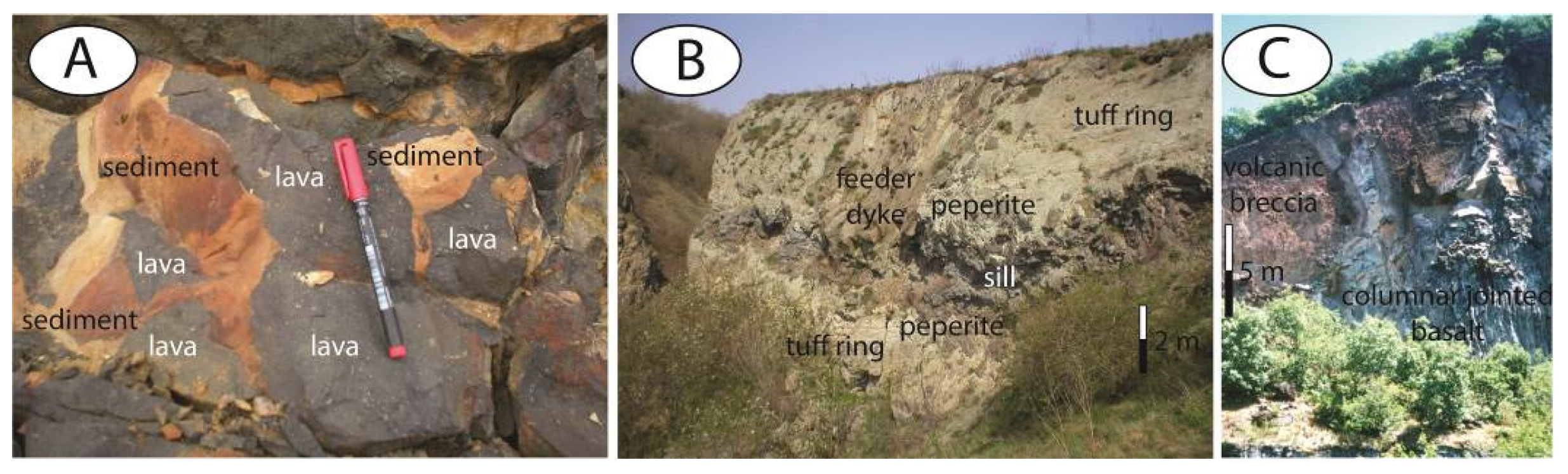
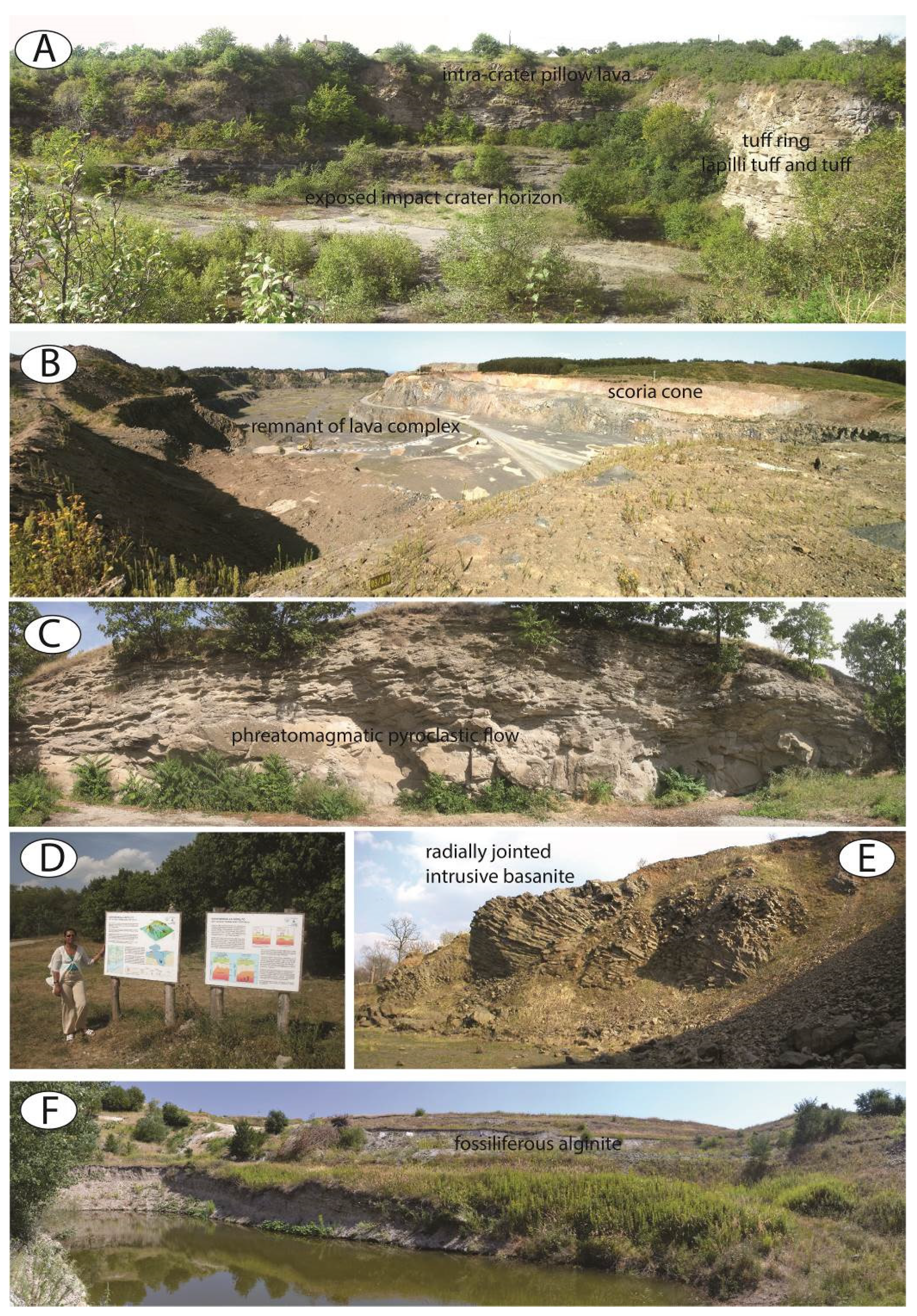
3.1.2. Western Hungary

In Western Hungary, two distinct monogenetic volcanic fields are recognized as Bakony–Balaton Highland and Little Hungarian Plain Volcanic Fields [65,66] (Figure 2). Both fields display a typical landscape formed by numerous eroded monogenetic volcanoes. Most of these volcanoes formed large phreatomagmatic edifices that were subsequently filled with various late magmatic infills like those in Auckland [49]. Hungarian locations are Plio-Pleistocene in age [67], in contrast to Auckland; hence, the volcanoes have been eroded back to their core of crater and upper conduit filling successions [68], with no preserved successions of former tuff ring or medial to distal parts of their original volcanic edifices preserved [69].
In addition, the high quality alkaline basaltic late magmatic infills, mostly solidified lava lakes, provided raw materials over 150 years, creating large, abandoned quarries with superbly exposed geological features of interiors of monogenetic volcanoes (Figure 4). Quarrying commonly exposed the subvolcanic magmatic bodies of columnar jointed basaltic intrusions (Figure 4A), showing fantastic variations of peperites and mixtures of coherent magma and host sediments (Figure 4B–D).
Peperites are so abundant in the abandoned western Hungarian basaltic quarry sites that they form a very solid base of scientific information on the formation of magma-sediment mingling textures as world class examples [70,71,72] (Figure 5). Various peperite textures such as blocky (Figure 5A) and globular (Figure 5B) as well as multiphase intrusive basaltic bodies are commonly exposed in large quarry walls that now fall under formal protection and function as key geosites to explain how magma and wet sediment can interact prior an explosive disruption.
As a result, numerous abandoned quarry sites in western Hungary have become key geosites, providing a unique view of monogenetic volcanism, as visitors can access the once violent volcanic conduit within the “frozen” interaction features that can be seen today (Figure 5). Many of these sites facilitate visualization of processes acting within a crater lake formed by captured fresh water subsequently invaded by lava, as seen at Kissomlyó in Western Hungary [73] (Figure 5A). While this site enjoys regional protection as a reserve, other locations such as Uzsa still function as an active quarry, resulting in continued removal of the interior of a former lava lake-filled tuff ring/scoria cone complex (Figure 5B).
While many of the abandoned quarries may not be considered visually attractive sites, their geological values are significant and relevant to various aspects of monogenetic volcanism (Figure 6A–E). Locations like the Pula abandoned alginate quarry (still functioning as local source of fertilizer) has limited protection status (Figure 6F). Pula is a Pliocene fossil “lagerstätte” (literal translation from German—“place of storage”, a lagerstätte is a sedimentary deposit that exhibits extraordinary fossils with exceptional preservation—sometimes including preserved soft tissues) formed within a deep maar crater that accumulated laminated crater lake sediments rich in micro and macro fossils over 100 m in thickness [74,75,76]. The site provides one of the most complete paleoenvironmental and paleontological records of terrestrial flora and fauna of Central Europe through the Pliocene. While the fossils are carefully guarded and transferred to collections, the low volume exploitation of the site mean new discoveries are inevitable due to the gradual extraction of raw material.
Overall, the western Hungarian monogenetic volcanoes provide older analogues for the core of young Auckland volcanoes; hence, the interconnection between such fields can be invaluable for volcanic hazard resilience and geoeducation.
Although Auckland has many abandoned quarry sites, there is little to no utilization of sites for volcanic geology education, as well as significant lack of promotion of potential connection of the AVF to similar fields elsewhere as a potential tool for broader geoeducation. This is particularly obvious in the southern part of the field where recent pressure of urbanization requiring a large volume of raw materials, leaving behind “scars” on the landscape that were once geo-culturally significant sites. While urbanization is viewed as inevitable in the greater Auckland area, modified sites that have “opened up” interiors of volcanic structures could function as key geosites in understanding eruption mechanisms of monogenetic volcanoes occurring in the future of this still active volcanic field underlying a city with a population of over 1.5 million inhabitants. Here we present a location where superb exposures associated with monogenetic volcanism have been documented as rapidly disappearing and are still threatened by seemingly unstoppable industrialization.

3.2. Volcanic Geoheritage Values of Auckland Volcanic Field

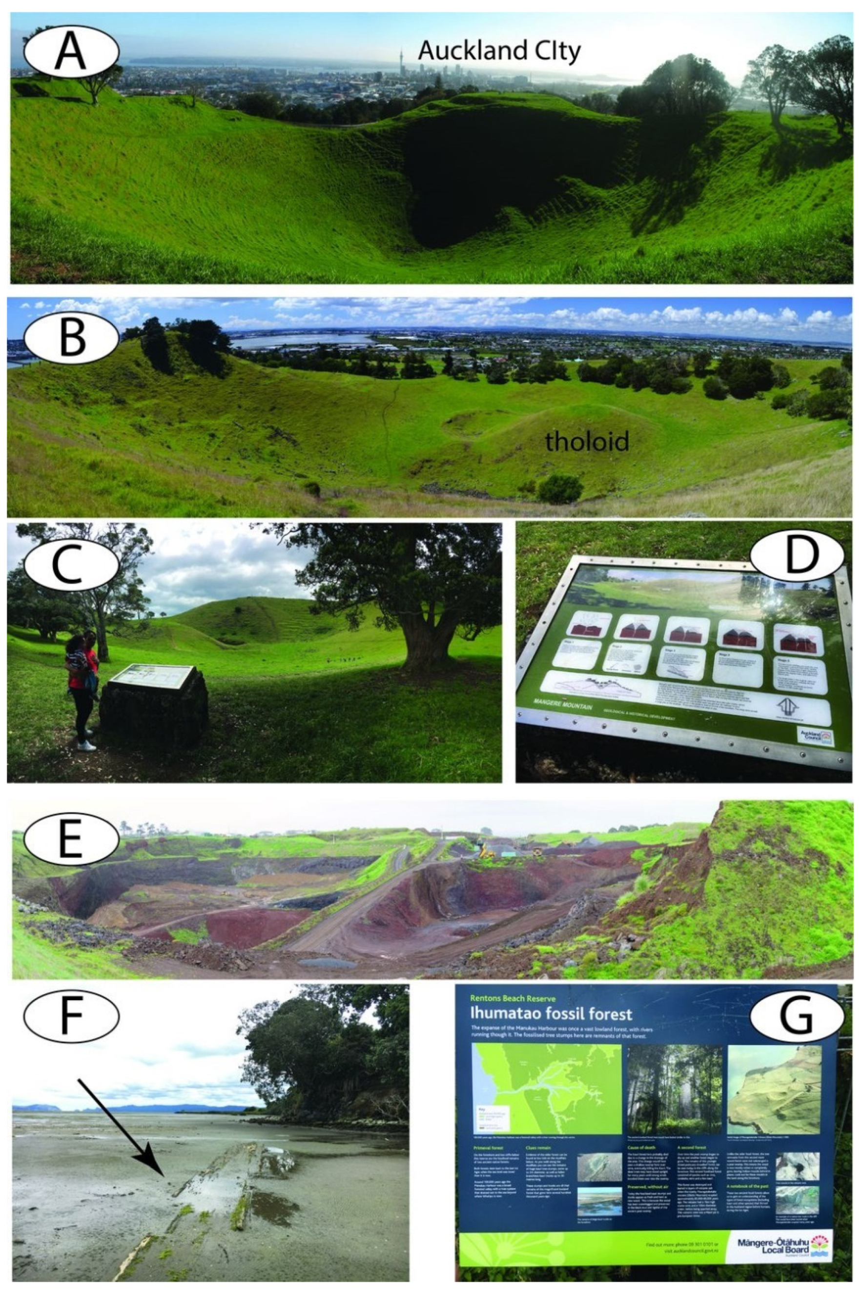
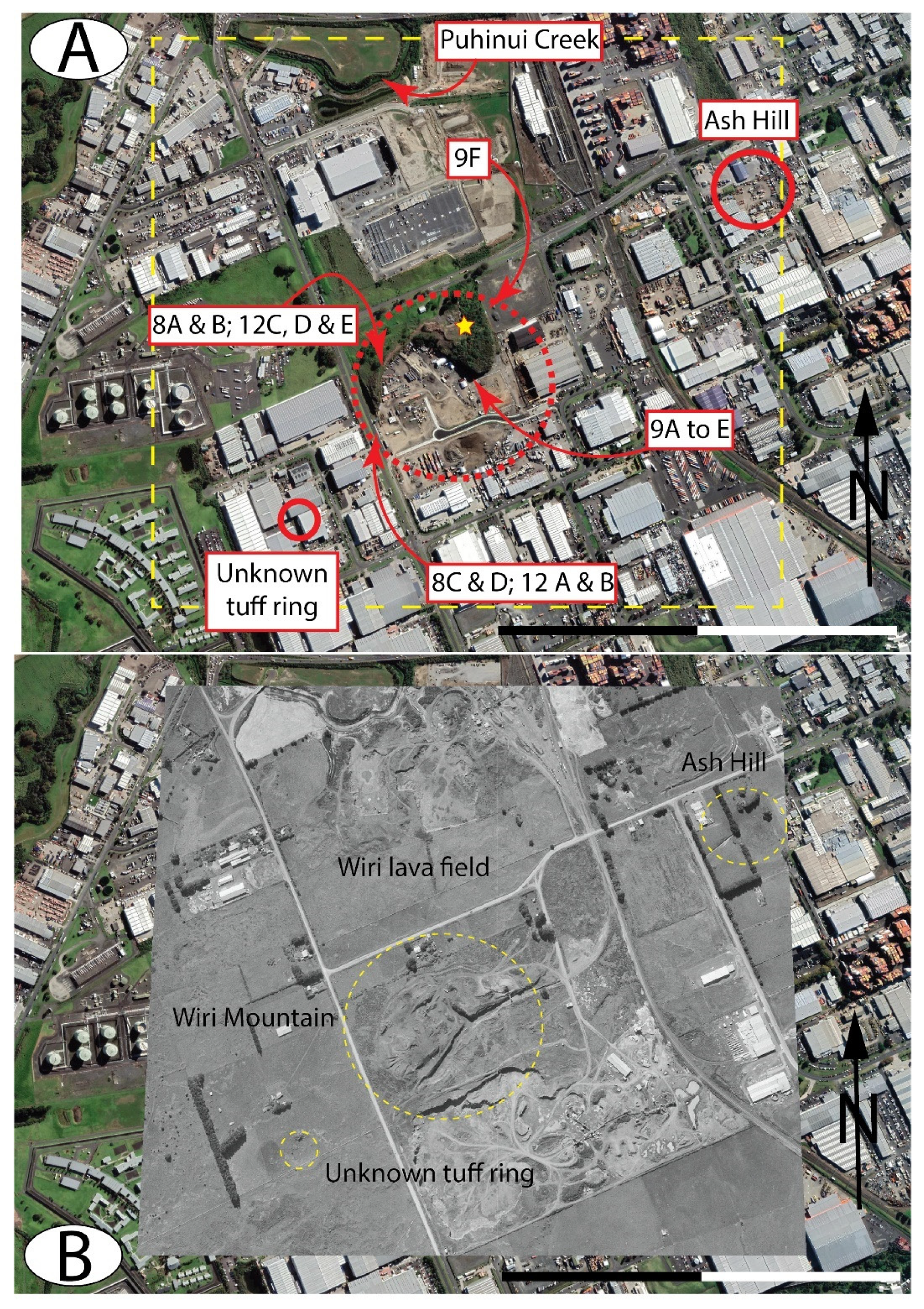
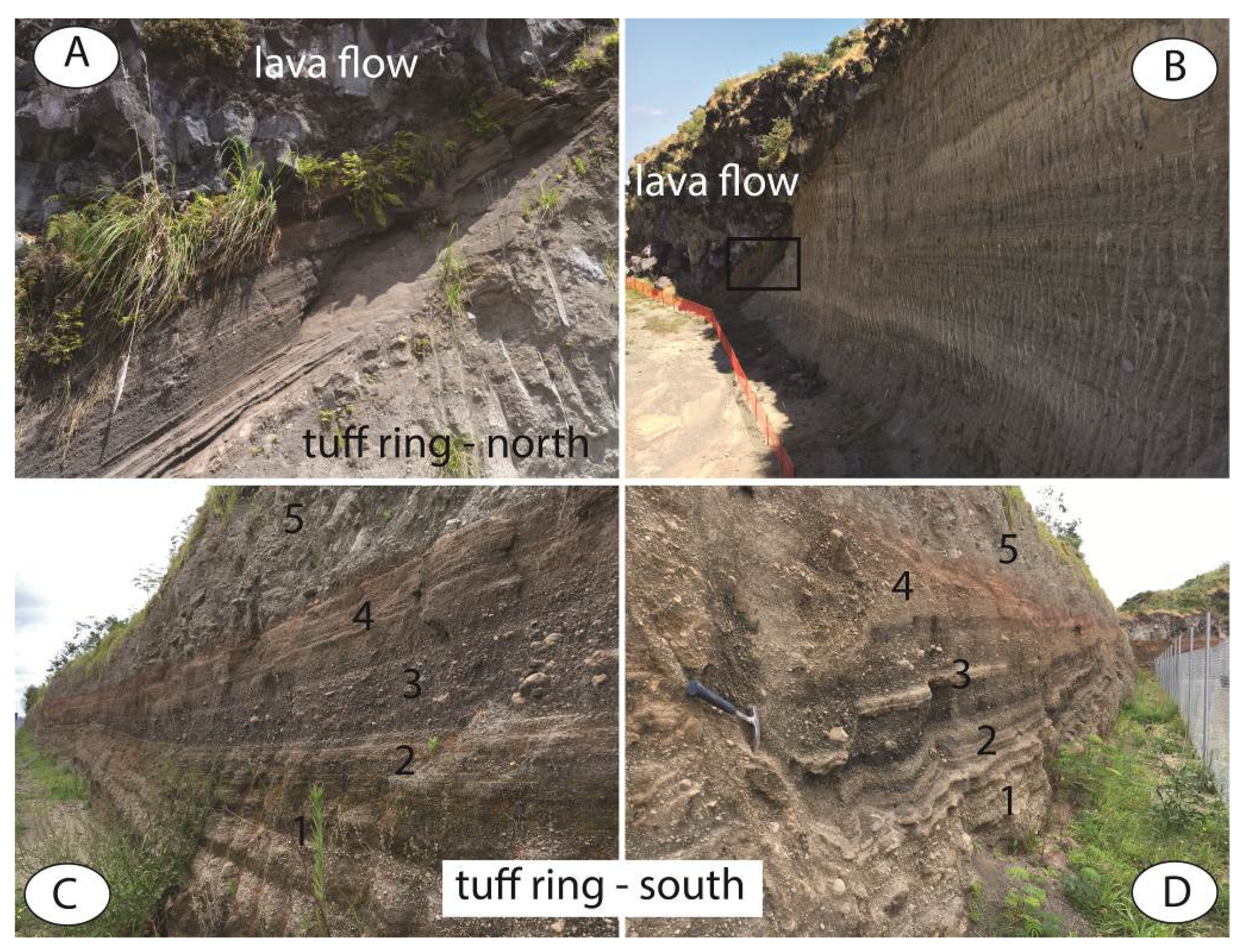
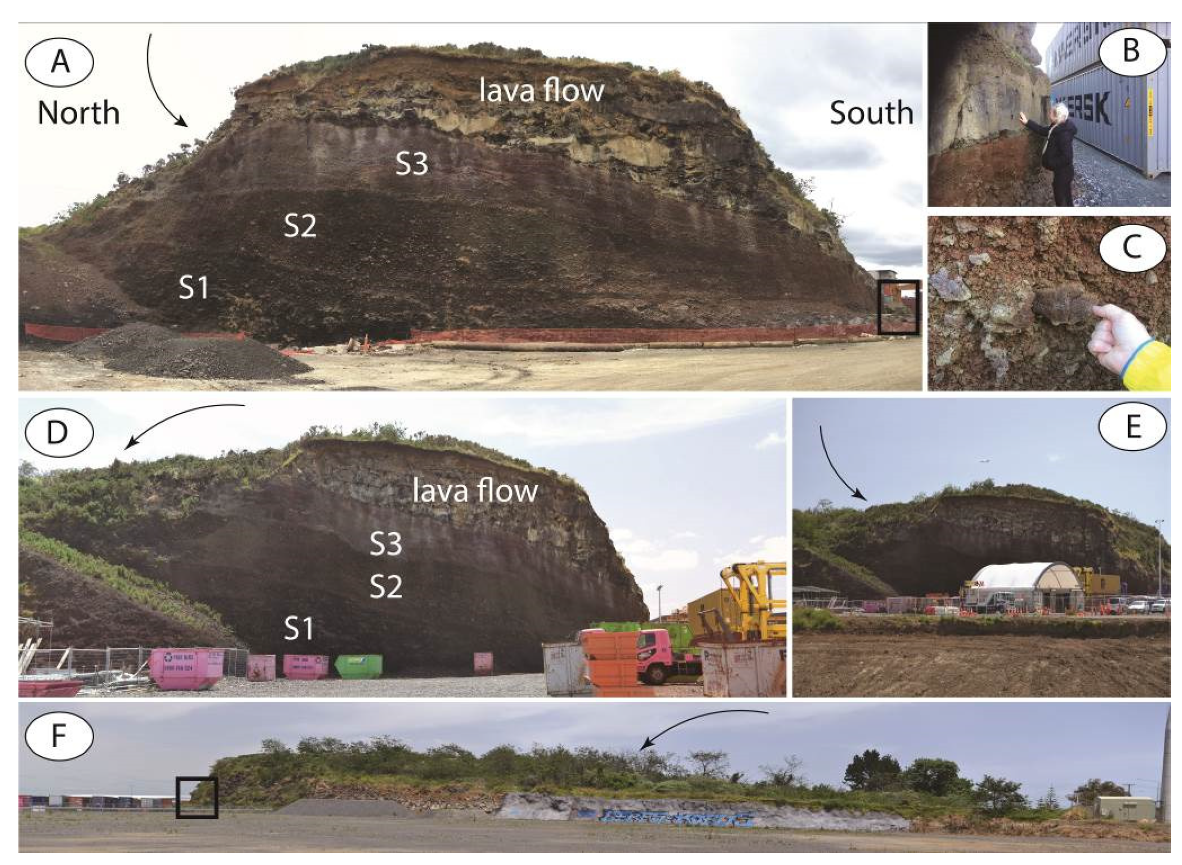
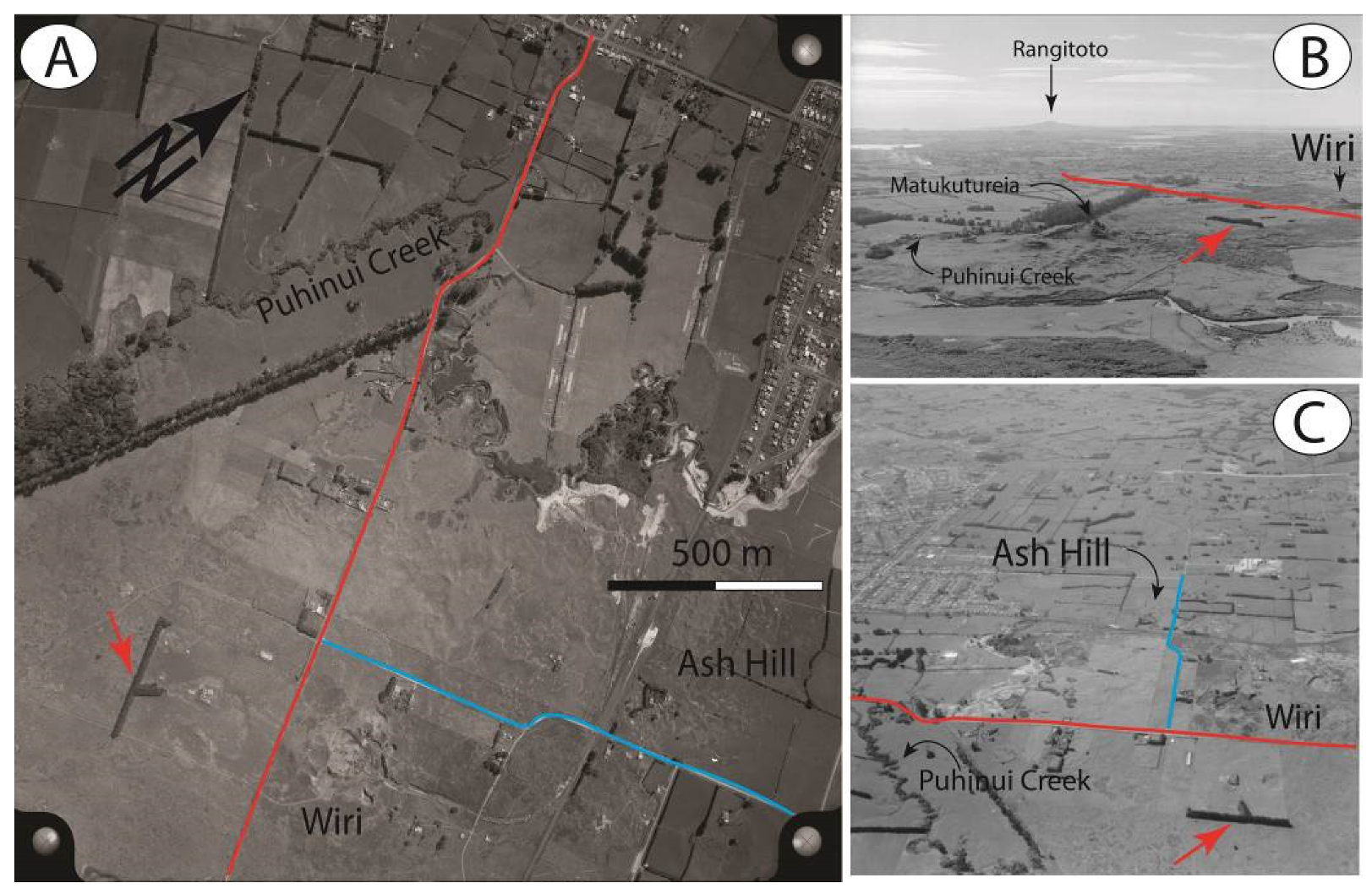
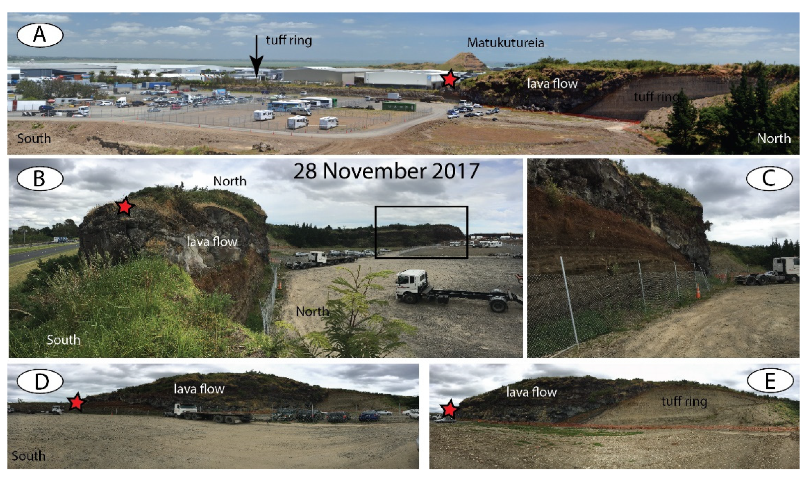
3.2.1. Wiri Mountain Region, South Auckland—A Complex Phreatomagmatic Volcano

Wiri Mountain (Matukutūruru) is part of a roughly NE-SW trending volcanic chain heavily altered by active quarrying and rapid urban expansion of South Auckland. Based on Ar-Ar and C14 geochronology and paleomagnetic data, Wiri Mountain very likely erupted in a time window between 32 and 34 ky, similarly to the nearby Ash Hill (32 ky) [51] (Figure 7).
Wiri Mountain is unique as it exposes continuous sections of a former basal tuff ring, including a 15 m thick proximal lapilli tuff succession. These features are typical of the initial explosive phreatomagmatic phase of tuff ring formation in the region (Figure 8A,B). This section exposes a transition zone of pyroclastic rocks covered by subsequent basaltic lava flows (Figure 8A). The transition zone indicates eruption style changes from purely phreatomagmatic to more magmatic explosive eruption-generated phases of the eruption. The lava flow appears to be part of a ponded lava lake that was exploited over 100 years of active quarrying, leaving behind a large crater in the ground. The main phreatomagmatic edifice is inferred to be in the northern part of the volcanic complex, while the southern regions feature distal phreatomagmatic pyroclastic successions. These more distal sections provide a nearly 200 m long and 2–4 m thick pile of pyroclastic rocks that could be accessed and studied to observe slight changes over this explosive stage of volcano growth. Within this pile of pyroclastic rocks, at least five distinct units were identified (Figure 8C,D), suggesting a very complex initial eruption history of the tuff ring growth phase of the volcano. This section has been gradually demolished prior to completion of scientific research on the rocks, preventing any future work on the site. In summary, the Wiri Mountain basal section is one of the best exposures in New Zealand of a near continuous succession of pyroclastic rocks typical of explosive phreatomagmatic eruptions of monogenetic volcanoes. Therefore, this provides valuable displays of products derived from the type of eruptions described. Detailed research and analysis of these rocks and volcanic features could be used to model a realistic eruption scenario that formed this volcano. This information could be utilized for geoeducation ventures related to volcanic hazard resilience of the population. As nearly all the volcanoes in the AVF have commenced eruption with explosive phreatomagmatic explosive processes forming a basal tuff ring, a near-continuous section both laterally and vertically has significant scientific value that should be preserved before modification causes further damage. While quarrying at these sites may have damaged the original geoform, exposing the near-vent tuff ring successions provides a great opportunity to preserve those remaining sections for scientific research and geoeducation.
Wiri Mountain also has a unique and complex magmatic capping unit forming the upper part of the volcanic succession (Figure 9). While the section itself is not significantly different from other complex and large volume monogenetic geoforms, the significance of the Wiri Mountain capping section lays in the fact that it is well exposed due to the quarrying, and displays a threefold pyroclastic unit indicating long lasting and gradually changing explosive phases in the final stage of the edifice growth (Figure 9A,B).
Scoria units can be seen having abruptly developed on the tuff ring succession (Figure 8A). The base of the section is more spatter dominated agglutinate with large cm-to-m-size bed flattened blobs of basalt (Figure 9A–C). This basal magmatic unit is covered by a more scoria lapilli-rich dark red unit with more distinct elongated lavas commonly exhibiting clastogenic texture (Figure 9B–D). The third unit is a more typical well packed scoria lapilli succession that is slightly bed-flattened. The entire magmatic cap is covered by a succession of lava flows that show clastogenic texture (Figure 9D–F) and some flattened and broken basalt lapilli (Figure 9C). The entire section is perfectly exposed by quarrying, allowing a unique view into the proximal half section of an evolving scoria cone that extruded lava out in its final eruptive phase (Figure 9D). On the far side (in the NE), the lava flows are also half sectioned by some long quarry cut surfaces, providing opportunities to observe the lava unit textural evolution up-section (Figure 9E). In this side of the former volcanic edifice, a long lava tube of (cave) about 200 m length is known to lie just a few meters below the surface. The urban development at the NE side of the remaining edifice is currently lies only a few tens of meters away from the location of the lava tube.

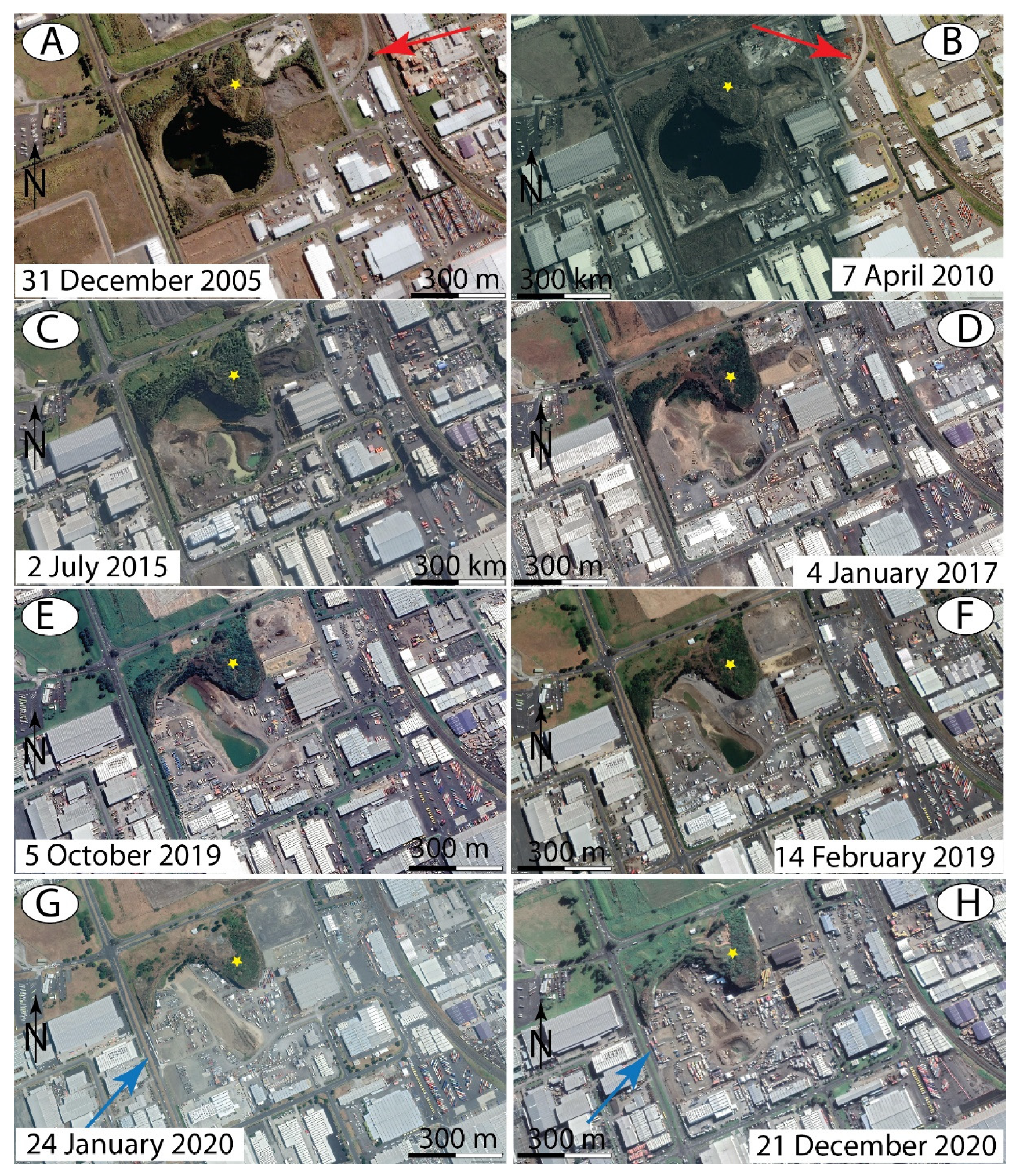
3.2.2. Urbanization and Quarrying at Wiri Mountain Region

Rapid urbanization and extraction of raw materials has had a significant impact on the Wiri Mountain region. This issue has been voiced through various blog posts (https://aotearoarocks.blogspot.com/2018/01/part-1-of-disappearing-maunga-of.html, accessed 1 June 2021; https://aotearoarocks.blogspot.com/2018/01/part-2-of-disappearing-maunga-of.html, accessed 1 June 2021). A visual narrative over the vanishing Wiri Mountain has also been published via web-based resources (https://aotearoarocks.blogspot.com/2018/08/guest-post-by-david-fraser-standing-up.html, accessed 1 June 2021). One of the most notable drivers of removal of these volcanoes is rapid expansion of the road and train network and the emergence of warehouses covering large surface areas. Through this process, large earthworks have cut and removed many volcanic sites. The north-easternmost eruption center in the volcanic chain that Wiri Mountain belongs to is Ash Hill. Once a small volcanic cone with a pronounced crater [78], by 2019 it had been completely removed and currently its remaining volcanic deposits lie under roading and large distribution warehouses (Figure 10). The former cone had a small, swampy crater section in its interior closely resembling a small tuff ring less than 200 m across its base. While the site has not been studied, photo records from 2005 show typical phreatomagmatic tuff breccia outcrops nearby [35], indicating that it was formed by what may have been the shortest eruption event of the AVF. What was the smallest tuff ring is now gone completely. Aerial photographs from the mi-20th century show a rural countryside (Figure 10) with a very low-density road network. Besides agricultural activity, the region had a low density of housing with natural vegetation along stream networks. Wiri Mountain was the main source of aggregate for the region, and the quarry could be accessed from the main north-south railway trunkline by a branch sideline (Figure 10A). As early quarrying exposed the interior of the volcano, it became evident that the edifice has some sort of low rimmed tuff ring filled with a magmatic cap and topped by a steep sided lava spatter-dominated cone with rugged lava flow surfaces. These features are typical of basaltic volcanoes erupting low viscosity magma over gradually steepened cone surfaces (Figure 10A). On the original and near-intact landscape, it is clearly visible that the Puhinui Creek followed the margin of the terminus of a lava flow field, likely formed as a combination of the effusive eruptions from the Wiri Mountain volcano chain (Figure 10B). In the SW end of the volcano chain, the McLaughlins (Matukutureia) volcano seems to form a similar volcanic massif as the Wiri Mountain itself (Figure 10B,C). While the center part of the McLaughlins Mountain has been heavily altered by quarrying, some morphological evidence suggests the presence of a single explosion crater in its SW extremity; however, no direct evidence through preserve pyroclastic successions is known from the region yet [35].
Following land coverage changes through the historic data set of GoogleEarth Pro since 2005), it becomes apparent that the Wiri Mountain complex went through dramatic changes (Figure 10). After complete removal of the capping scoria cone and proximal lava flows that filled the crater with high quality dense lava material, quarrying went on to exploit the core of the volcanic cone. As a result, the open pit quarry removed rock formed by the ponded and degassed lava, with a high economic value as dense (low vesicularity) basalts. This left behind the tuff ring and proximal magmatic explosive caping units (Figure 11). It is apparent that the quarry pit rapidly filled with water in the early 2010s, and subsequently filled with debris from the 2015s onward, creating land for an industrial storage yard. From 2017 onwards the quarry was transformed completely, continuing to function as a dumping area in its center but gradually expanding as a storage yard. From 2019, a significant activity can be observed to “tidy” up the site and develop it as suitable land for a shared storage facility for a range of vehicles and industrial equipment providers. Similar trends can be observed in other South Auckland former quarry sites. By early 2020, through this process of incremental encroachment and destruction, the main tuff ring section in the west had been nearly completely removed.

3.2.3. Loss of Volcanic Geoheritage in the Wiri Region

The loss of volcanic geoheritage at Wiri Mountain can be observed through satellite imagery and through direct on-ground observation. Two site visits occurring in 2017 (Figure 12) and 2019 (Figure 13) observed dramatic changes in the quarry walls. In 2017 it would have been possible to “rescue” the scientifically important tuff ring sections, contact exposure sections and the magmatic infill sections (Figure 12). However, by 2019 nothing remained of these features at these locations. On the image dated 28 November 2017, we can clearly see the long continuous tuff ring section forming a type of natural barrier between the quarry site and encroaching urban development (Figure 12A). However, by 2019 the same feature had been completely removed. Unfortunately, this would have been the best exposure of a proximal tuff ring succession of the active monogenetic volcanic field of Auckland. Thankfully, sampling was completed prior to removal, hence some data will likely be available soon, but it cannot be revisited, restudied, and, most importantly, used for geoeducation purposes. The remaining section can be accessed from a public road outside the quarry; however, outcrops are overgrown and not as well-exposed and self-explanatory as those accessed from the quarry garden direction (Figure 13).
In addition to the physical loss, the quarry has been used in a very intrusive way from 2019 onward as more and more businesses have taken advantage of the newly reclaimed land, utilizing the site as various “depot” or storage facility. As a result, in 2019, the site had been filled with a large number of containers, making it nearly impossible to access or clearly see the remaining geosites exposing the contact between the phreatomagmatic tuff ring succession, the transitional pyroclastic zone and the capping lava flows (Figure 13A–D).

3.2.4. Broader South Auckland Context

If we expand our observations across the broader region of South Auckland, we can observe losses occurring over the same time period (Figure 14). GoogleEarth Pro historic satellite imagery reveals that the Wiri Mountain volcanic chain has lost the majority of the key geosites. This is demonstrated by the complete removal of Ash Hill and rapid development at McLaughlins Mountain, resulting in a dramatic loss of volcanic geology information [35].

4. Discussion—Urbanization and Geoheritage Loss in the Greater Auckland Region

While Wiri Mountain is clearly at the frontline of urban development in South Auckland, similar losses of volcanic geoheritage can be seen elsewhere in critical sites of the Auckland Volcanic Field. We define critical sites in the context of Auckland volcanism as those that provide the most complex geological information and displaying the full spectrum of volcanic processes responsible for their formation. The AVF is a relatively young volcanic field where most of the geosites have been obscured, modified, or destroyed by urbanization occurring since the earliest days of European settlement. Accessible sites allowing observation of the full section of pyroclastic successions from the base to the top are rare. Most of these sites are associated with former or current quarry sites. While it may be inevitable that extraction of raw materials such as scoria and basalt will modify and damage original landscape features, we recognize these locations as providing invaluable opportunities to observe volcanic successions that would otherwise remain buried deep beneath our feet. This is particularly the case in young volcanic fields. Many young volcanic fields across Europe utilize their abandoned quarries of monogenetic volcanoes as their key geoeducation spots [79,80,81,82,83]. By interlinking young and old monogenetic volcanic fields and cross-communicating the information made accessible, we can maximize education and community engagement opportunities at these sites. In the case of Auckland, the greatest volcanic hazard is expected to be phreatomagmatic in nature. Although we may observe basal pyroclastic rocks formed during initial phreatomagmatic explosive phases at many locations in the AVF, the South Auckland region is the most complex in this respect, providing a wealth of locations readily accessible for research (Figure 15). In addition to Wiri Mountain, we define here four key locations clearly demonstrating the unstructured approach to mitigating effects of quarrying and preserving geoheritage value these sites may offer (Figure 15 and Figure 16).
One of the only still active quarries is located at Maungataketake (also known as Ellet’s Mountain), where a deep pit has clearly exposed the internal structure of a complex phreatomagmatic to magmatic explosive and effusive volcano (Figure 15A–D). From 2005 to 2020, development of the quarry pit is clearly visible, and once extraction of raw material was complete the pit was infilled with waste. The quarry remains inaccessible to visitors, including scientists, with all attempts at engagement with the owners to gain access unsuccessful. Although the site is one of the best exposed locations of the shallow subsurface architecture of a wet volcano, it has not been scientifically studied to any degree and remains unlikely to be in the near future. In contrast, a publicly accessible coastal site that is part of the same volcanic complex provides an excellent 1 km long tuff ring section where the visitor can follow the proximal to distal section of base surge dominated tuff ring succession. Being able to research these sites in parallel would result in a scientific overview of the growth of the volcano through proximal and crater-filling successions, as well as providing opportunities for education and engagement with visitors to the area.
A similar scenario has been played out at Crater Hill (Figure 15E–H), with a distinct difference that this site provided one of the first and best geochemical reference sites to document chemical variations occurring during the eruption of a small wet monogenetic volcano. After the quarry ceased active operations, key sites rapidly filled with waste. After a long-lasting Environmental Court action, an agreement was reached to restore the site to its original landscape appearance (similar to how some maar craters were recreated in the Vulkaneifel in Germany—http://www.globalgeopark.org/news/news/5934.htm, accessed 1 June 2021), recreating a tuff ring partially filled with scoria and spatter cones, and retaining a crater lake in its center. While we acknowledge this as a positive outcome from an aesthetic and geoform perspective, the fact that the key sites of scientific study of geochemical stratigraphy [84,85] have been destroyed, has resulted in an irreversible scientific loss. This situation also reflects an expensive and time-consuming legal strategy that is reactive and unlikely to be sustainable in the long-term against well-resourced commercial developers and landowners.
The third location is the Waitomokia (also known as Mount Gabriel) tuff ring complex, composed of a large tuff ring with a shallow maar crater that was partially occupied with at least three scoria cones and some short lava flows (Figure 15I–L). The site is now occupied by a winery operated by the Villa Maria Estate, which have made significant investments in making the site a recreational center based on food and wine. The Fourth International Maar Conference in 2012 hosted its conference dinner in the recreational facilities, with aspirations for future collaborations between the winery and the scientific community with the area acknowledged as the center of several volcanic geosites. While this idea remains to be fully realized, the site appears to have been subject to similar degradational processes as others in the area with little to no action taken on facilitating the necessary processes to make the aspiration a reality. Once-free access to key proximal phreatomagmatic explosion breccia exposures has become incorporated into a restricted operations area. Over time we have observed that once access is restricted by commercial operations, this process is highly unlikely to be reversed without significant and complex negotiations requiring time, effort, and financial input. Therefore, we can confidently say that the loss of public access to these sites facilitated by an active operating business is likely to be permanent.
The fourth location that demonstrates an ad hoc and reactive approach to acquiring geological information is Pukewairiki (Highbrook Park) (Figure 16). The location was well known as a tuff ring and appeared in the early geological maps; however, the lack of outcrops prevented acquisition of more detailed information about the volcano. The geoform was covered by grass and due to its location adjacent to the Tamaki Estuary escaped encroachment from urban expansion until 2005 (Figure 16A–D). From 2005 onwards, rapid construction of large warehouses and retail centers commenced in the region. During the initial development phase large warehouses were planned for the northern crater rim with earthworks likely to dissect the tuff ring and expose its interior. As expected, around 2007–2008 the tephra rings had been cross-cut in several locations, providing superb exposure of altered fine grained dune-bedded pyroclastic surge beds (Figure 16E,F). However, with development in the area complete, these exposures are now covered and inaccessible. They are lost for future research or utilization for geoeducation, in spite of their significant scientific value demonstrating a perfect longitudinal and cross-sectional view of pyroclastic surge deposits from one of most hazardous volcanic processes likely to occur in the future across the low lands of South Auckland [86].
Overall, if we compare the documented volcanic sites in Auckland for their geoheritage and geoeducation potential of what remains of volcanic features, the huge information loss and underutilization of these sites becomes obvious. In addition, urbanization is inevitable in a rapidly growing city like Auckland, especially during housing and transportation crises in a post-pandemic time. We note the seeming lack of vision for preservation of volcanic geoheritage and geoeducation in the context of volcanic hazard resilience. While scientific programs such as the Determining Volcanic Risk in Auckland (DEVORA) (https://www.devora.org.nz/, accessed 1 June 2021) have made a huge impact on linking end-users and the scientific community, and collating information to form a coherent model for understanding volcanic hazard of Auckland, it has had little direct impact on at least slowing rapid information loss or offering an alternative model to utilize these values.
The Bakony–Balaton UNESCO Global Geopark (http://www.geopark.hu/en/, accessed 1 June 2021), as a well-resourced and well-supported geopark, provides an example of the importance of volcanic geoheritage in regions where no active volcanism is recorded, and most of the geosites are coincident with or resulted from raw material exploitation. Such a trend is clear across the geopark programs in many regions, mostly in the continental Europe (such as the Vulcania volcano theme park in France—https://www.vulcania.com/en/, accessed 1 June 2021), and we suggest this as a potential model for Auckland in the future.
The Bakony–Balaton UNESCO Global Geopark to some extent similar (volcano type, geotectonic setting, eruption styles, number of volcanoes, etc.) to the Auckland Volcanic Field, could provide a model in terms of geoeducation and geoconservation of volcanic landscapes for Auckland. The Hungarian examples show clearly that volcanic geoheritage can play a main driving force to develop a sustainable geoconservation strategy. However, the Hungarian case may only indirectly be useful for modeling a solution for problems typical of the AVF such as rapidly accelerating urbanization and exploitation of volcanic geosites for short-term benefits. The foundation of a geopark with UNESCO status could be seen as the ultimate outcome reconciling conflicting and often opposing values and needs in terms of usage of volcanic landscapes. We suggest that such a concept needs to be researched and developed in Auckland urgently. In this concept, ideas such as the Vulcania volcano theme park in France might be a potential model for Auckland in the future. However, development of such geoeducational centers is unlikely to halt urbanization but could reduce it to a sustainable level and in parallel change local governments and community’s attitudes towards supporting conservation and accessibility of key geosites. We acknowledge these as hypothetical and largely aspirational ideas in the current socio-economic climate, underlain by a housing crisis, the COVID-19 pandemic, and growth of Auckland as the largest population center in the country. Nonetheless, we suggest that strategic planning to preserve significant abiotic aspects of the environment on an equal footing with its biotic aspects, is likely to be the only way forward for sustainable evolution of the wider Auckland region.
Overall, we have highlighted markers of insufficient care for the conservation of volcanic heritage in the Auckland area. We suggest an important area of research should address reasons behind the apparent lack of effective geopreservation policy in the largest urban center of New Zealand. Questions that remain unexplored and unanswered are: Is this only due to physical proximity to the city? How does Auckland compare with other cities with similar types of volcanic geoheritage? Could the relative ubiquity of volcanic geoforms in New Zealand contribute to bias within conservation strategies and general attitudes toward volcanic geoheritage? Attitudes to volcanic landforms in this country can be contrasted to Central Europe, where remnants of volcanism are considered special or even unique, in that regions in question have no active volcanism and active volcanoes are rare and may be considered “mystic” natural phenomena for most of the people. Such relative perspective might be the reason why various regions act differently toward geopreservation of their volcanic geoheritage.

5. Conclusions

In this semiquantitative study, we provided observation-based data from satellite imagery, historic photos, and direct observations on the rapid speed of geoheritage site loss in the greater Auckland urban area. We argued that geoheritage values of monogenetic volcanic fields are important in facilitating volcanic hazard resilience programs. This is especially important in regions like the active Quaternary Auckland Volcanic Field. We also acknowledged that raw material needs are increasing hence quarrying is inevitable in rapidly growing urban areas like Auckland. However, the resulting quarries could be used in a far more effective, logical, and visionary way for sustainable urban growth demonstrated through our case-studies. The examples we presented from western Hungary demonstrated general geoconservation aspects of abandoned quarries across continental Europe, which could provide viable links in developing programs within Auckland. The interlinking of volcanic fields composed of young and largely intact geoforms with those of similar origin but older, hence eroded, or intensively quarried and deeply exposed volcanic fields through geoheritage programs is considered a cost-effective and very natural program to follow, suggested here as valuable for the future development of geoconservation and geoheritage ventures in Auckland.

Author Contributions

Conceptualization, K.N. and I.G.; methodology, B.N. and K.N.; validation, K.N., I.G. and B.N.; investigation, K.N. and B.N.; resources, I.G. and B.N.; data curation, I.G.; writing—original draft preparation, K.N.; writing—review and editing, I.G. and K.N. All authors have read and agreed to the published version of the manuscript.

Funding

This research was funded by Earthquake Commission of New Zealand AND Auckland Regional Council titled as “DEVORA—Investigate how geoheritage values in Auckland may be incorporated in planning and public education”, grant number GNS-EQC00046.

Institutional Review Board Statement

Not applicable.

Informed Consent Statement

Not applicable.

Acknowledgments

The authors are thankful for the support provided by EQC–ARC–DEVORA to pursue this research. We are grateful for all the fruitful discussions with Peter Crossley (Lave Cave research and field work) and Bruce Hayward (Auckland geoheritage, Wiri Mountain, Crater Hill geopreservation). We also thank the four anonymous reviewers whose formal reviews improved the quality of the manuscript significantly.

Conflicts of Interest

The authors declare no conflict of interest.

References

  1. Smith, I.E.M.; Németh, K. Source to surface model of monogenetic volcanism: A critical review In Monogenetic Volcanism; Németh, K., Carrasco-Nuñez, G., Aranda-Gomez, J.J., Smith, I.E.M., Eds.; Geological Society of London Special Publications; The Geological Society Publishing House: Bath, UK, 2017; pp. 1–28. [Google Scholar]
  2. Guilbaud, M.-N.; del Pilar Ortega-Larrocea, M.; Cram, S.; de Vries, B.v.W. Xitle Volcano Geoheritage, Mexico City: Raising Awareness of Natural Hazards and Environmental Sustainability in Active Volcanic Areas. Geoheritage 2021, 13. [Google Scholar] [CrossRef]
  3. Mikhailenko, A.V.; Ruban, D.A.; Zorina, S.O.; Nikashin, K.I.; Yashalova, N.N. The human imprint on the unique geological landscape of the Western Caucasus. Geologos 2020, 26, 233–244. [Google Scholar] [CrossRef]
  4. Migon, P.; Pijet-Migon, E. Late Palaeozoic Volcanism in Central Europe-Geoheritage Significance and Use in Geotourism. Geoheritage 2020, 12. [Google Scholar] [CrossRef]
  5. Brzezinska-Wojcik, T.; Skowronek, E. Tangible Heritage of the Historical Stonework Center in Brusno Stare in the Roztocze Area (SE Poland) as an Opportunity for the Development of Geotourism. Geoheritage 2020, 12. [Google Scholar] [CrossRef] [Green Version]
  6. Sousa, L.; Lourenco, J.; Pereira, D. Suitable Re-Use of Abandoned Quarries for Restoration and Conservation of the Old City of Salamanca-World Heritage Site. Sustainability 2019, 11, 4352. [Google Scholar] [CrossRef] [Green Version]
  7. Prosser, C.D. Communities, Quarries and Geoheritage-Making the Connections. Geoheritage 2019, 11, 1277–1289. [Google Scholar] [CrossRef]
  8. Kubalikova, L.; Kirchner, K.; Kuda, F.; Machar, I. The Role of Anthropogenic Landforms in Sustainable Landscape Management. Sustainability 2019, 11, 4331. [Google Scholar] [CrossRef] [Green Version]
  9. Gajek, G.; Zglobicki, W.; Kolodynska-Gawrysiak, R. Geoeducational Value of Quarries Located Within the Malopolska Vistula River Gap (E Poland). Geoheritage 2019, 11, 1335–1351. [Google Scholar] [CrossRef] [Green Version]
  10. Comentale, B. Disused stone quarries in urban landscape, a feature of geoheritage: Case studies from Paris and Nantes. Physio-Geo 2019, 13, 1–24. [Google Scholar] [CrossRef]
  11. Careddu, N.; Grillo, S.M. “Trachytes” from Sardinia: Geoheritage and Current Use. Sustainability 2019, 11, 3706. [Google Scholar] [CrossRef] [Green Version]
  12. Brocx, M.; Semeniuk, V. Building Stones Can Be of Geoheritage Significance. Geoheritage 2019, 11, 133–149. [Google Scholar] [CrossRef]
  13. Prosser, C.D. Geoconservation, Quarrying and Mining: Opportunities and Challenges Illustrated Through Working in Partnership with the Mineral Extraction Industry in England. Geoheritage 2018, 10, 259–270. [Google Scholar] [CrossRef]
  14. Tom, H.; Gurli, M. Assessment of Ancient Stone Quarry Landscapes as Heritage Sites; Engineering Geology for Society and Territory; Berlin, Germany; Springer International Publishing, 2015; Volume 8, pp. 253–256. [Google Scholar]
  15. Guilbaud, M.N.; van Wyk de Vries, B.; Nemeth, K.; Vereb, V.; Hagos, M.; Manrique, N.; Fermet-Quinet, N.; Irapta, N.; Vargas, S.V.; Cortés, G.P.; et al. UNESCO IGCP Project 692. Geoheritage for geohazard resilience: A global initiative to share knowledge, raise awareness and communicate about natural hazards. In Proceedings of the Oxford Geoheritage Virtual Conference, Oxford, UK, 25 May 2020; pp. 67–68. [Google Scholar]
  16. Salazar, C.L.A.; Manrique, N.; Aguilar, R.; van Wyk de Vries, B. Geosite assessment in Arequipa City–Peru: UNESCO IGCP 692 project ‘Geoheritage for Geohazard Resilience’. In Proceedings of the EGU General Assembly 2021, Online, 19–30 April 2021. EGU21-8355. [Google Scholar] [CrossRef]
  17. Delage, E.; Van Wyk De Vries, B.; Philippe, M.; Conway, S.; Morino, C.; Llerena, N.M.; Contreras, R.A.; Soncco, Y.; Sæmundsson, Þ.; Helgason, J.K. Visualising and experiencing geological flows in Virtual Reality. In Proceedings of the EGU General Assembly 2021, Online, 19–30 April 2021. EGU21-8801. [Google Scholar] [CrossRef]
  18. Vörös, F.; Pál, M.; van Wyk de Vries, B.; Székely, B. Development of a New Type of Geodiversity System for the Scoria Cones of the Chaîne des Puys Based on Geomorphometric Studies. Geosciences 2021, 11, 58. [Google Scholar] [CrossRef]
  19. Fuertes-Gutierrez, I.; Garcia-Ortiz, E.; Fernandez-Martinez, E. Anthropic Threats to Geological Heritage: Characterization and Management: A Case Study in the Dinosaur Tracksites of La Rioja (Spain). Geoheritage 2016, 8, 135–153. [Google Scholar] [CrossRef]
  20. Stefano, M.; Paolo, S. Abandoned Quarries and Geotourism: An Opportunity for the Salento Quarry District (Apulia, Southern Italy). Geoheritage 2017, 9, 463–477. [Google Scholar] [CrossRef]
  21. Ruban, D.A.; Tiess, G.; Sallam, E.S.; Ponedelnik, A.A.; Yashalova, N.N. Combined mineral and geoheritage resources related to kaolin, phosphate, and cement production in Egypt: Conceptualization, assessment, and policy implications. Sustain. Environ. Res. 2018, 28, 454–461. [Google Scholar] [CrossRef]
  22. Marescotti, P.; Brancucci, G.; Sasso, G.; Solimano, M.; Marin, V.; Muzio, C.; Salmona, P. Geoheritage Values and Environmental Issues of Derelict Mines: Examples from the Sulfide Mines of Gromolo and Petronio Valleys (Eastern Liguria, Italy). Minerals 2018, 8, 229. [Google Scholar] [CrossRef] [Green Version]
  23. Coratza, P.; Vandelli, V.; Soldati, M. Environmental rehabilitation linking natural and industrial heritage: A Master Plan for dismissed quarry areas in the Emilia Apennines (Italy). Environ. Earth Sci. 2018, 77. [Google Scholar] [CrossRef]
  24. Redondo-Vega, J.M.; Gomez-Villar, A.; Santos-Gonzalez, J.; Gonzalez-Gutierrez, R.B.; Alvarez-Martinez, J. Changes in land use due to mining in the north-western mountains of Spain during the previous 50 years. Catena 2017, 149, 844–856. [Google Scholar] [CrossRef]
  25. Ferrero, E.; Giardino, M.; Lozar, F.; Giordano, E.; Belluso, E.; Perotti, L. Geodiversity action plans for the enhancement of geoheritage in the Piemonte region (North-Western Italy). Ann. Geophys. 2012, 55, 487–495. [Google Scholar] [CrossRef]
  26. Ruchkys, U.d.A.; Castro, P.d.T.A.; Ribeiro, S.M.C.; Alvarenga, L.J. Applying geoethics to the context of mining ferruginous geosystems: Case studies from the tailing dam breaks in Fundao and Corrego do Feirao, Minas Gerais-Brazil. Episodes 2020, 43, 981–990. [Google Scholar] [CrossRef]
  27. De Pascale, F.; Dattilo, V. The Geoethical Semiosis of the Anthropocene: The Peircean Triad for a Reconceptualization of the Relationship between Human Beings and Environment. Ann. Am. Assoc. Geogr. 2020, 111, 647–654. [Google Scholar] [CrossRef]
  28. Ruchkys, U.d.A.; Castro, P.d.T.A.; Miranda, M.P.S. Mining in Ferruginous Geosystems and Geoethics Issues: The case of the tailings dam rupture of Corrego do Feijao, Minas Gerais-Brazil. Confins-Revue Franco-Bresilienne De Geographie-Revista Franco-Brasileira De Geografia 2019, 40. Available online: http://journals.openedition.org/confins/19973 (accessed on 7 June 2021). [CrossRef]
  29. Gordon, J.E. Geoheritage, Geotourism and the Cultural Landscape: Enhancing the Visitor Experience and Promoting Geoconservation. Geosciences 2018, 8, 136. [Google Scholar] [CrossRef] [Green Version]
  30. Di Capua, G.; Peppoloni, S.; Bobrowsky, P.T. The Cape Town Statement on Geoethics. Ann. Geophys. 2017, 60. [Google Scholar] [CrossRef] [Green Version]
  31. Piedrabuena, M.A.P.; Molist, J.M.; Bergua, S.B.; Alfonso, J.L.M. The Deterioration of Geoheritage in the Central Spanish Volcanic Region by Open-Pit Mining. Geoheritage 2019, 11, 1903–1917. [Google Scholar] [CrossRef]
  32. Pal, M.; Albert, G. Examining the Spatial Variability of Geosite Assessment and Its Relevance in Geosite Management. Geoheritage 2021, 13. [Google Scholar] [CrossRef]
  33. Pal, M.; Albert, G. Identifying Outcrops for Geological Hiking Maps. In Proceedings of the 7th International Conference on Cartography and Gis, Vols 1 and 2, Sozopol, Bulgaria, 18–23 June 2018; International Conference on Cartography and GIS. Bandrova, T., Konecny, M., Eds.; Bulgarian Cartographic Association: Sozopol, Bulgaria, 2018; pp. 98–107. [Google Scholar]
  34. Horváth, G.; Lóczy, D. Geoheritage, Geoconservation, Geomorphosites in Hungary. In Landscapes and Landforms of Hungary; Volume World Geomorphological Landscapes; Lóczy, D., Ed.; Springer: Heidelberg, Germany, 2015. [Google Scholar] [CrossRef]
  35. Hayward, B.W. Volcanoes of Auckland: A Field Guide; Auckland University Press: Auckland, New Zealand, 2019; ISBN 9781869409012. [Google Scholar]
  36. Hayward, J.J.; Hayward, B.W. Fossil forests preserved in volcanic ash and lava at Ihumatao and Takapuna, Auckland. Tane 1995, 35, 127–142. [Google Scholar]
  37. Kenny, J.A.; Hayward, B.W. Inventory and Maps of Important Geological Sites and Landforms in the Auckland Region and Kermadec Islands; Geological Society of New Zealand: Lower Hutt, New Zealand, 1996; Volume 84, p. 59. [Google Scholar]
  38. Hayward, B.; Murdoch, G.; Maitland, G. Volcanoes of Auckland: The Essential Guide; Auckland University Press: Auckland, New Zealand, 2011; p. 234. [Google Scholar]
  39. Németh, K.; Kereszturi, G. Monogenetic volcanism: Personal views and discussion. Int. J. Earth Sci. 2015, 104, 2131–2146. [Google Scholar] [CrossRef]
  40. Agustin-Flores, J.; Siebe, C.; Ferres, D.; Sieron, K.; Gonzalez-Zuccolotto, K. Monogenetic volcanoes with initial phreatomagmatic phases in the Ceboruco graben, western Mexico: The cases of Potrerillo I, Potrerillo II, and San Juanito. J. Volcanol. Geotherm. Res. 2021, 412. [Google Scholar] [CrossRef]
  41. Ureta, G.; Nemeth, K.; Aguilera, F.; Gonzalez, R. Features That Favor the Prediction of the Emplacement Location of Maar Volcanoes: A Case Study in the Central Andes, Northern Chile. Geosciences 2020, 10, 507. [Google Scholar] [CrossRef]
  42. Ang, P.S.; Bebbington, M.S.; Lindsay, J.M.; Jenkins, S.F. From eruption scenarios to probabilistic volcanic hazard analysis: An example of the Auckland Volcanic Field, New Zealand. J. Volcanol. Geotherm. Res. 2020, 397. [Google Scholar] [CrossRef]
  43. Nieto-Torres, A.; Del Pozzo, A.L.M. Spatio-temporal hazard assessment of a monogenetic volcanic field, near Mexico City. J. Volcanol. Geotherm. Res. 2019, 371, 46–58. [Google Scholar] [CrossRef]
  44. Kereszturi, G.; Bebbington, M.; Nemeth, K. Forecasting transitions in monogenetic eruptions using the geologic record. Geology 2017, 45, 283–286. [Google Scholar] [CrossRef]
  45. Deligne, N.I.; Fitzgerald, R.H.; Blake, D.M.; Davies, A.J.; Hayes, J.L.; Stewart, C.; Wilson, G.; Wilson, T.M.; Castelino, R.; Kennedy, B.M.; et al. Investigating the consequences of urban volcanism using a scenario approach I: Development and application of a hypothetical eruption in the Auckland Volcanic Field, New Zealand. J. Volcanol. Geotherm. Res. 2017, 336, 192–208. [Google Scholar] [CrossRef]
  46. Nemeth, K.; Moufti, M.R. Geoheritage Values of a Mature Monogenetic Volcanic Field in Intra-continental Settings: Harrat Khaybar, Kingdom of Saudi Arabia. Geoheritage 2017, 9, 311–328. [Google Scholar] [CrossRef]
  47. Nemeth, K. Volcanic geoheritage values of monogenetic volcanic fields in the global scale and from New Zealand perspective. Geosci. Soc. N. Z. Misc. Publ. 2016, 145A, 59. [Google Scholar]
  48. Gao, W.; Li, J.; Mao, X.; Li, H. Geological and Geomorphological Value of the Monogenetic Volcanoes in Wudalianchi National Park, NE China. Geoheritage 2013, 5, 73–85. [Google Scholar] [CrossRef]
  49. Nemeth, K.; Cronin, S.J.; Haller, M.J.; Brenna, M.; Csillag, G. Modern analogues for Miocene to Pleistocene alkali basaltic phreatomagmatic fields in the Pannonian Basin: “soft-substrate” to “combined” aquifer controlled phreatomagmatism in intraplate volcanic fields. Cent. Eur. J. Geosci. 2010, 2, 339–361. [Google Scholar] [CrossRef] [Green Version]
  50. Hopkins, J.L.; Smid, E.R.; Eccles, J.D.; Hayes, J.L.; Hayward, B.W.; McGee, L.E.; van Wijk, K.; Wilson, T.M.; Cronin, S.J.; Leonard, G.S.; et al. Auckland Volcanic Field magmatism, volcanism, and hazard: A review. N. Z. J. Geol. Geophys. 2020, 1–22. [Google Scholar] [CrossRef]
  51. Lindsay, J.; Leonard, G.; Smid, E.; Hayward, B. Age of the Auckland Volcanic Field: A review of existing data. N. Z. J. Geol. Geophys. 2011, 54. [Google Scholar] [CrossRef]
  52. Kereszturi, G.; Németh, K.; Cronin, S.J.; Procter, J.; Agustin-Flores, J. Influences on the variability of eruption sequences and style transitions in the Auckland Volcanic Field, New Zealand. J. Volcanol. Geotherm. Res. 2014, 286, 101–115. [Google Scholar] [CrossRef]
  53. Kereszturi, G.; Nemeth, K. Sedimentology, eruptive mechanism and facies architecture of basaltic scoria cones from the Auckland Volcanic Field (New Zealand). J. Volcanol. Geotherm. Res. 2016, 324, 41–56. [Google Scholar] [CrossRef]
  54. Gravis, I.; Nemeth, K.; Procter, J.N. The Role of Cultural and Indigenous Values in Geosite Evaluations on a Quaternary Monogenetic Volcanic Landscape at IhumAtao, Auckland Volcanic Field, New Zealand. Geoheritage 2017, 9, 373–393. [Google Scholar] [CrossRef]
  55. Burns, B.R.; Dodd, M.B.; Hartnett, T. Auckland’s green volcanic heart: Groundcover vegetation and soils of the Auckland volcanic cone reserve network. J. R. Soc. N. Z. 2013, 43, 184–197. [Google Scholar] [CrossRef] [Green Version]
  56. Taylor, L.; Leckey, E.H.; Lead, P.J.; Hochuli, D.F. What Visitors Want From Urban Parks: Diversity, Utility, Serendipity. Front. Environ. Sci. 2020, 8. [Google Scholar] [CrossRef]
  57. Horrocks, M.; Nichol, S.L.; D’Costa, D.M.; Shane, P.; Prior, C. Palaeoenvironment and human impact in modifying vegetation at Mt St John, Auckland Isthmus, New Zealand. N. Z. J. Bot. 2005, 43, 211–221. [Google Scholar] [CrossRef] [Green Version]
  58. Agustin-Flores, J.; Nemeth, K.; Cronin, S.J.; Lindsay, J.M.; Kereszturi, G.; Brand, B.D.; Smith, I.E.M. Phreatomagmatic eruptions through unconsolidated coastal plain sequences, Maungataketake, Auckland Volcanic Field (New Zealand). J. Volcanol. Geotherm. Res. 2014, 276, 46–63. [Google Scholar] [CrossRef]
  59. Xu, T.; Gao, J.; Coco, G. Simulation of urban expansion via integrating artificial neural network with Markov chain-cellular automata. Int. J. Geogr. Inf. Sci. 2019, 33, 1960–1983. [Google Scholar] [CrossRef]
  60. Xu, T.; Gao, J. Directional multi-scale analysis and simulation of urban expansion in Auckland, New Zealand using logistic cellular automata. Comput. Environ. Urban Syst. 2019, 78. [Google Scholar] [CrossRef]
  61. Silva, C. Auckland’s Urban Sprawl, Policy Ambiguities and the Peri-Urbanisation to Pukekohe. Urban Sci. 2019, 3, 1. [Google Scholar] [CrossRef] [Green Version]
  62. Golson, J.; Fowlds, G. Auckland’s Volcanic Cones: A Report on Their Condition and a Plea for Their Preservation; Historic Auckland Society; Unity Press: Auckland, New Zealand, 1957; p. 32. [Google Scholar]
  63. Garcia, R.A.; Aschenbrenner, M.; Duerr, E.; Winder, G. Re-imagining cities as ecosystems: Environmental subject formation in Auckland and Mexico City. Urban Res. Pract. 2020. [Google Scholar] [CrossRef]
  64. Curran-Cournane, F.; Cain, T.; Greenhalgh, S.; Samarsinghe, O. Attitudes of a farming community towards urban growth and rural fragmentation-An Auckland case study. Land Use Policy 2016, 58, 241–250. [Google Scholar] [CrossRef] [Green Version]
  65. Martin, U.; Nemeth, K. Mio/Pliocene phreatomagmatic volcanism in the western Pannonian Basin. Geol. Hung. Ser. Geol. 2004, 26, 192. [Google Scholar]
  66. Németh, K. An Overview of the Monogenetic Volcanic Fields of the Western Pannonian Basin: Their Field Characteristics and Outlook for Future Research from a Global Perspective. In Updates in Volcanology-A Comprehensive Approach to Volcanological Problems; Stoppa, F., Ed.; InTech: Rijeka, Croatia, 2012; pp. 27–52. [Google Scholar]
  67. Wijbrans, J.; Nemeth, K.; Martin, U.; Balogh, K. ⁴⁰Ar/³⁹Ar geochronology of Neogene phreatomagmatic volcanism in the western Pannonian Basin, Hungary. J. Volcanol. Geotherm. Res. 2007, 164, 193–204. [Google Scholar] [CrossRef]
  68. Németh, K.; Csillag, G.; Martin, U. Lepusztult freatomagmás vulkáni kráter és kürtőkitörés-roncsok (diatrémák) a Bakony-Balaton-felvidék vulkáni területen. A Magyar Állami Földtani Intézet évi jelentése (2001) 2003, 83–99. Available online: https://mro.massey.ac.nz/bitstream/handle/10179/9637/viewcontent.pdf?sequence=1&isAllowed=y (accessed on 7 June 2021).
  69. Hencz, M.; Karátson, D.; Németh, K.; Biró, T. A Badacsony freatomagmás piroklasztitösszlete: Következtetések a monogenetikus bazaltvulkáni működés folyamataira és formáira = The phreatomagmatic pyroclastic sequence of the Badacsony Hill: Implications for the processes and landforms of monogenetic basaltic volcanism. Földtani közlöny 2017, 147, 297–310. [Google Scholar] [CrossRef] [Green Version]
  70. Martin, U.; Nemeth, K. Peperitic lava lake-fed sills at Sag-hegy, western Hungary: A complex interaction of a wet tephra ring and lava. In Physical Geology of High-Level Magmatic Systems; Breitkreuz, C., Petford, N., Eds.; Geological Society Special Publication: London, UK, 2004; Volume 234, pp. 33–50. [Google Scholar]
  71. Martin, U.; Németh, K. Blocky versus fluidal peperite textures developed in volcanic conduits, vents and crater lakes of phreatomagmatic volcanoes in Mio/Pliocene volcanic fields of Western Hungary. J. Volcanol. Geotherm. Res. 2007, 159, 164–178. [Google Scholar] [CrossRef]
  72. Nemeth, K.; Martin, U. Shallow sill and dyke complex in western Hungary as a possible feeding system of phreatomagmatic volcanoes in “soft-rock” environment. J. Volcanol. Geotherm. Res. 2007, 159, 138–152. [Google Scholar] [CrossRef]
  73. Martin, U.; Németh, K. Eruptive and depositional history of a Pliocene tuff ring that developed in a fluvio-lacustrine basin: Kissomlyó volcano (Western Hungary). J. Volcanol. Geotherm. Res. 2005, 147, 342–356. [Google Scholar] [CrossRef]
  74. Kovacs, J.; Nemeth, K.; Szabo, P.; Kocsis, L.; Kereszturi, G.; Ujvari, G.; Vennemann, T. Volcanism and paleoenvironment of the pula maar complex: A pliocene terrestrial fossil site in Central Europe (Hungary). Palaeogeogr. Palaeoclimatol. Palaeoecol. 2020, 537. [Google Scholar] [CrossRef]
  75. Nemeth, K.; Goth, K.; Martin, U.; Csillag, G.; Suhr, P. Reconstructing paleoenvironment, eruption mechanism and paleomorphology of the Pliocene Pula maar, (Hungary). J. Volcanol. Geotherm. Res. 2008, 177, 441–456. [Google Scholar] [CrossRef]
  76. Willis, K.J.; Kleczkowski, A.; Briggs, K.M.; Gilligan, C.A. The role of sub-Milankovitch climatic forcing in the initiation of the Northern Hemisphere glaciation. Science 1999, 285, 568–571. [Google Scholar] [CrossRef]
  77. Gravis, I.; Nemeth, K.; Twemlow, C.; Nemeth, B. The Case for Community-Led Geoheritage and Geoconservation Ventures in Mangere, South Auckland, and Central Otago, New Zealand. Geoheritage 2020, 12. [Google Scholar] [CrossRef]
  78. Hayward, B.W. Ash Hill Volcano, Wiri. Geocene 2008, 8–9. Available online: https://www.researchgate.net/publication/256767533_Ash_Hill_volcano_Wiri (accessed on 7 June 2021).
  79. Martí, J.; Planagumà, L. (Eds.) La Garrotxa Volcanic Field of Northeast. Spain; Springer: Heidelberg, Gemany, 2017; p. 136. [Google Scholar]
  80. Doniz-Paez, J.; Beltran-Yanes, E.; Becerra-Ramirez, R.; Perez, N.M.; Hernandez, P.A.; Hernandez, W. Diversity of Volcanic Geoheritage in the Canary Islands, Spain. Geosciences 2020, 10, 390. [Google Scholar] [CrossRef]
  81. Doniz-Paez, J.; Quintero Alonso, C. Urban geoturism rutes in Icod de Los Vinos (Tenerife, Canary Islands, Spain): A proposal. Cuad. Geogr. 2016, 55, 320–343. [Google Scholar]
  82. Doniz-Paez, J.; Becerra-Ramirez, R.; Gonzalez-Cardenas, E.; Guillen-Martin, C.; Escobar-Lahoz, E. Geomorphosites and geotourism in volcanic landscape: The example of La Corona del Lajial cinder cone (El Hierro, Canary Islands, Spain). Geoj. Tour. Geosites 2011, 8, 185–197. [Google Scholar]
  83. Planaguma, L.; Marti, J. Identification, cataloguing and preservation of outcrops of geological interest in monogenetic volcanic fields: The case of La Garrotxa Volcanic Zone Natural Park. Geoheritage 2020, 12. [Google Scholar] [CrossRef]
  84. Smith, I.E.M.; Blake, S.; Wilson, C.J.N.; Houghton, B.F. Deep-seated fractionation during the rise of a small-volume basalt magma batch: Crater Hill, Auckland, New Zealand. Contrib. Mineral. Petrol. 2008. [Google Scholar] [CrossRef]
  85. Houghton, B.F.; Wilson, C.J.N.; Rosenberg, M.D.; Smith, I.E.M.; Parker, R.J. Mixed deposits of complex magmatic and phreatomagmatic volcanism: An example from Crater Hill, Auckland, New Zealand. Bull. Volcanol. 1996, 58, 59–66. [Google Scholar] [CrossRef]
  86. Brand, B.D.; Gravley, D.M.; Clarke, A.B.; Lindsay, J.M.; Bloomberg, S.H.; Agustin-Flores, J.; Nemeth, K. A combined field and numerical approach to understanding dilute pyroclastic density current dynamics and hazard potential: Auckland Volcanic Field, New Zealand. J. Volcanol. Geotherm. Res. 2014, 276, 215–232. [Google Scholar] [CrossRef] [Green Version]
Figure 1. Auckland Volcanic Field (AVF) on a simplified geological map with the main volcano types (A) and the area in a GoogleEarth satellite image (B) marking major quarry sites host significant volcanic geoheritage sites and/or recreational facilities. The black rectangle shows the greater Wiri Mountain study area. Significant volcanic heritage sites with some geoheritage and recreational purposes are marked with blue circles. Other abandoned quarries under urbanization pressure are marked with red circles (A—Ōtuataua & Pukeiti; B—Te Tātua-a-Riukiuta/Three Kings; C—Maungarei/Mt Wellington; D—Pupuke). Yellow circles represent scientifically significant partially quarried tuff ring sites studied extensively (1—Maungataketake/Ellets Mountain; 2—Moerangi/Waitomokia/Mt Gabriel; 3—Crater Hill; 4—Pukewairiki/Highbrook Park).
Sustainability 13 06549 g001
Figure 2. Plio-Pleistocene monogenetic volcanic fields (Bakony–Balaton Highland and Little Hungarian Plain Volcanic Fields) in western Hungary showing the most important quarry sites with volcanic geoheritage values and variable protection status.
Sustainability 13 06549 g002
Figure 3. Significant volcanic geoheritage values of the Auckland Volcanic Field. (A) Mount Eden scoria cone with lookout to Auckland City; (B) Mangere Mountain scoria cone complex with a tholoid; (C) explanatory board within the Mangere Mountain scoria cone crater; (D) explanation board about the stages of scoria cone formation; (E) quarried interior of the Mangataketake tuff ring/scoria cone complex exposing the shallow sub-crater zone of a monogenetic volcano, unfortunately quickly quarried away with no public access; (F) Pleistocene forest under a tuff ring succession of the Maungataketake tuff ring; (G) explanation board to explain the origin of the fossil forest beneath the phreatomagmatic tuff succession of Maungateketake.
Sustainability 13 06549 g003
Figure 4. Older and partially eroded monogenetic volcanoes expose the sub-crater or shallow subvolcanic architecture of monogenetic volcanoes, demonstrating that quarry sites can have exceptional geoheritage values such as those in western Hungary. In the western part of the Bakony–Balaton Highland Volcanic Field, outside of the Bakony–Balaton UNESCO Global Geopark territory, active and semi-active quarries (A,B—Sümegprága, C,D—Bazsi) expose such intrusive bodies with peperite (C,D), indicating the role of intruding basalt melt and wet unconsolidated sediments.
Sustainability 13 06549 g004
Figure 5. Former quarries in western Hungary commonly became significant geosites showing the exposed interior of monogenetic volcanoes, including blocky peperite in Hajagos-hegy (A), globular peperitic sills in Ság-hegy (B), and complex interaction of lava and cone building pyroclastic rocks at Badacsony (C). For textural details, the reader is referred to the electronic version of the paper to “zoom” into the images.
Sustainability 13 06549 g005
Figure 6. Abandoned quarry sites of monogenetic volcanoes quickly became recreational and geoeducational sites such as Kissomlyó exposing a lava lake emplaced into a Pliocene tuff ring (A). Large active quarries such as Uzsa (B) allow visitors to see the changing quarry walls gradually exposing the interior of a large tuff ring–scoria cone complex. Abandoned quarry sites within the Bakony–Balaton UNESCO Global Geopark act as important geosites (C) with information boards about the geological features visible in the sites such as those of the hydroclastic flow of Szentbékkálla (D). Quarries such as those outside the territory of the protected areas, such as many abandoned quarries nearby Sümegprága (E), function as alternative geosites; however, their protection, due to demand for raw materials, can be problematic at times. An abandoned alginate quarry of a former maar lake at Pula (F) functions as an internationally significant geosite with exceptionally well-preserved fossil assemblages like those of Messel in Germany or Foulden Hill in Otago, New Zealand [77]. For textural details, the reader is referred to the electronic version of the paper to “zoom” into the images.
Sustainability 13 06549 g006
Figure 7. Wiri Mountain and its surrounding with the key sites mentioned in the paper, on GoogleEarth Pro Satellite image from 2021 (A). Historical aerial photography from 14 April 1972 (Source: https://retrolens.co.nz/map/#/, accessed 1 June 2021) fitted on the current GoogleEarth Pro 2021 satellite image to show the extent of urbanization in the region (B). Wiri Mountain, Ash Hill and a newly recognized “unknown tuff ring” are marked by yellow dashed ellipses in (B). Ash Hill and the newly recognized “unknown tuff ring” are marked by thick red ellipses in (A), showing the complete coverage of their geoforms under urban layers. The outline of the remains of Wiri Mountain is marked by dashed red ellipse in (A). The yellow star marks the entrance of the Wiri lava tube on (A). Scale is 1 km long in both (A,B). Arrows and associated numbers refer to the figure numbers showing features from the sites the arrows point.
Sustainability 13 06549 g007
Figure 8. Basalt quarrying at Wiri Mountain over a century has exposed superb quarry walls as key geosites valuable to understanding the evolution of volcanoes of Auckland. (A) Unconformity surfaces between phreatomagmatic tuff rings and capping magmatic pyroclastic and coherent lava flow units are important locations to depict geological conditions where such eruption style changes occurred. (B) Basalt tuff ring succession is informative for understanding the pyroclastic density current operating in that stage of the volcano growth. Note that the black rectangle corresponds to the field of view shown in Figure 8A. (C) Long, continuous outcrops exposed by quarrying are rare and important sites; however, urban expansion and high demand for raw materials threaten their preservation. (D) The numbers refer to distinct pyroclastic units: (1) lithic-rich pyroclastic density current deposited succession, (2) lithic-rich pyroclastic density current deposit with increasing amount of juvenile pyroclasts, (3) poorly sorted, massive pyroclastic density current deposited unit, (4) bedded, juvenile-rich pyroclastic density current deposit, and (5) coarse grained thickly bedded, massive pyroclastic density current deposited unit.
Sustainability 13 06549 g008
Figure 9. Wiri Mountain quarrying exposed the upper, magmatic capping successions of the former complex volcano, showing multiple layers of scoria and spatter successions marked as S1, S2, and S3 units below the capping lava flows (AD). Arrows on the (A,DF) mark the location of the entry point of the lava tube of Wiri Mountain. The exposed sections provide superb examples of magmatic explosive and effusive processes (B,C), but they are gradually diminishing due to urbanization and raw material needs (E,F). The black rectangles on (A,F) mark the same area shown in (B,C).
Sustainability 13 06549 g009
Figure 10. Wiri Mountain quarrying exposed the upper, magmatic capping successions of the former complex volcano, showing multiple layers of scoria and spatter successions. The exposed sections superb to explain the magmatic explosive and effusive processes but they are gradually diminishing due to the urbanization and raw material needs. In each frame, the red lines mark the same road for better orientation. In (A,C), blue lines also represent corresponding roads. In (A,B), Red arrows point to the same tree line on each image for better orientation. The base of the Wiri cone complex coincides roughly with the area captured by the blue and red roads on (A) and the disturbed (quarried) area that mark more or less the main part of the cone. Aerial photographs are from Auckland Museum collections.
Sustainability 13 06549 g010
Figure 11. Wiri Mountain outcrop changes over time due to quarrying. Images were captured from GoogleEarth Pro Historic Database. Blue arrows point to the same roads and red arrows to the same train tracks for better orientation. Yellow star marks the Wiri Mountain lava cave entry point. Image dates (day, month and year) are: (A)—31 December 2005; (B)—7 April 2010; (C)—22 July 2015; (D)—4 January 2017; (E)—5 October 2018; (F)—14 February 2019; (G)—24 January 2020; (H)—21 December 2020.
Sustainability 13 06549 g011
Figure 12. The changes of Wiri Mountain due to quarrying and damping activity shown well on these images taken on 28 November 2017.A section of a tuff ring is still preserved (A), exposing valuable contact between basal tuff ring and capping magmatic explosive and effusive units (B,C). The quarry wall was still accessible and clean, providing perfect locations for visitors (D,E). Red stars mark the same locations on (A,B,D,E).
Sustainability 13 06549 g012
Figure 13. By 22 November 2019, the majority of the tuff ring section was barricaded by container and car storage (A,B). The tuff ring section became difficult to access (BD) and a long section was removed completely in the south (E). Red stars in each frame represent the same location.
Sustainability 13 06549 g013
Figure 14. Historic GoogleEarth Pro images showing the dramatic pressure of urbanization on the broader Wiri Mountain region. In each frame, Wiri Mountain is marked by a red circle. Numbers in each frame (AH) show the situations from older to younger times. Time format is day, month and year in each frame.
Sustainability 13 06549 g014
Figure 15. Time frames from GoogleEarth Pro historic satellite imagery shows the dramatic changes of key geosites with high scientific values. (AD) show the Maungataketake tuff ring from the recent times back to 2005. (EH) frames show Crater Hill in roughly the same time slices as Maungataketake. (IL) show the landform changes of Pukewairiki/Highbrook Park.
Sustainability 13 06549 g015
Figure 16. Dramatic changes on the Pukewairiki/Highbrooks Park tuff ring due to urban development within a 15-year-long time frame. GoogleEarth Pro historic satellite imagery shows the situation from 2020 (A), 2017 (B), 2007 (C) and 2005 (D) situations. The dates on each image are in year, month, and day format. Red stars in (AD) mark the same location in each frame that is also captured in a temporarily opened outcrop of fantastic base surge dune beds (E). An impact sag in (E) is marked by a circle, suggesting transportation direction from the west. Base surge dunes (arrow) are well preserved despite that the pyroclastic rocks are altered. Yellow lines in (A) mark the view angle shown in (F).
Sustainability 13 06549 g016
Publisher’s Note: MDPI stays neutral with regard to jurisdictional claims in published maps and institutional affiliations.

