
Toward the Sustainable Metropolis: The Challenge of Planning Regulation


1
Department of Geography and Environmental Development, Ben-Gurion University of the Negev, Beersheba 8410501, Israel
2
Azrieli School of Architecture, Tel Aviv University, Tel Aviv 6997801, Israel
*
Author to whom correspondence should be addressed.
Sustainability 2021, 13(15), 8189; https://0-doi-org.brum.beds.ac.uk/10.3390/su13158189
Submission received: 17 June 2021
/
Revised: 12 July 2021
/
Accepted: 18 July 2021
/
Published: 22 July 2021
(This article belongs to the Special Issue Cultural, Legal and Political Dimensions of Public Norms in Sustainable Metropolitan Spaces)
Abstract
:Promoting urban sustainability and resilience is a demanding and challenging task. This paper focuses on the obstacles related to planning and regulation that stem from the structure of urban planning apparatuses and the substantial incompatibilities between them and common urban dynamics. Based on case studies from Tel Aviv-Jaffa, whose urban structure and municipal management appear to support the vision of urban sustainability and resilience, this paper presents three types of obstacles and concludes with four major challenges. The first obstacle relates to keeping urban infrastructure updated according to new technologies and knowledge. The second involves acknowledging the unintended consequences of planning actions, particularly those engaged with “green” policies. The third refers to confronting entrenched urban structures and processes. The practical obstacles include awareness of the widening social and spatial gaps that may result from uneven sustainability and resilience adaptation; the importance of keeping “open minds” about the required adaptation of plans and facilities to new knowledge and technologies; awareness of the fact that big plans require prolonged processes, which likely means timely adaptation of programs and means; and the need to facilitate communication between urban and governmental bodies and prepare for frequent coordination and consultation in various combinations.
1. Introduction
The lively academic discussion on urban sustainability and resilience depicts the characteristics of the (aspirational) sustainable and resilient city (SARC) in an ambiguous and sometimes contradictory manner. Both the definitions of terms and the solutions to the problems they represent appear to be contested [1,2]. Despite disagreements, the New Urbanist framework of a dense, diversified, and interconnected built environment is often presented as a preferable urban fabric for meeting the challenge by both international organizations (see: [3,4,5]) and scholars [6,7]. Particular attention is given to urban planning and regulation as the generator and control mechanism behind creating and maintaining a sustainable and resilient city. From the morphological perspective, planning policies and actions are expected to reduce sprawl and advance compact development [8]. Inside the city, planning is anticipated to improve connectivity, “green” urban transportation, and open spaces while enhancing diversity and mixed land use. These features are associated with reduced consumption and greenhouse gas emissions and create urban agents’ action capacity and knowledge accumulation [9]. From the dynamic point of view, planning is expected to advance the ideal of a highly adaptive built environment, one that is capable of and exercises short- and long-term changes at all scales. For example, cities adopt new, healthy solutions after pandemic outbreaks [10]. The anticipated model depicts a decentralized urban structure hosting various private, public, and administrative actors working for the sake of their interests yet in wide collaboration with each other. This image is associated with great openness toward emerging stipulations, technological innovations, and new knowledge instead of centralized and top-down urban management [11]. As Pizzo [1] stresses, the idea is not necessarily to choose between open, spontaneous, self-organizing dynamics and organized collective behavior, but to maneuver between them, and combine the dispersed activity with an inclusive point of view.
This paper deals with the obstacles faced by urban planning and regulation when trying to cope with this morphological and dynamic vision. The research shows that planning practice requires numerous adaptations in order to realize the aspired ideal. Focusing on Tel Aviv-Jaffa, Israel, whose urban fabric and diversified dynamics match the ideal framework, we point out the embedded obstacles. Tel Aviv-Jaffa was chosen because it exemplifies municipal engagement with environmental issues and is highly committed to advancing urban sustainability and resilience. From this starting point and looking at the urban–environment relationship as part of larger, open, complex systems of actions and reactions, we wonder how planning can practically synchronize the various scales to better fit with social and environmental needs. After a short review of the existing knowledge and concepts, we briefly present the methodology. The article then examines three cases, each representing one obstacle faced when attempting to achieve sustainability and resilience goals: the complexity of adapting relatively large urban infrastructure to new knowledge and policies; the difficulty of acknowledging the unintended consequences of beneficial planning actions and getting trapped in contradictory results; the obstacles created by entrenched, path-dependent processes and structures.
1.1. Planning for Sustainability and Resilience
Cities stand at the central point for reducing the human ecological footprint and enhancing humanity’s ability to survive extreme conditions [12,13,14]. The research regarding urban sustainability and resilience touches on numerous components of urban–environment reciprocity, including types and means of energy, water supply, solid waste, and sewage management methods, air and soil pollution reduction, and other derivatives. These issues were traditionally investigated separately, but recent approaches tend to develop a more holistic viewpoint, and look at sustainable, resilient urbanism patterns. An in-depth analysis of the academic literature on urban sustainability provided by [15] shows that while in the 1990s, the discussion focused mainly on isolated aspects of urban sustainability, since 2010 and especially since 2015, a more mature and holistic discourse was reached. The new discourse encompasses green urban dynamics, such as energy consumption and mitigating pollution, and places land-use issues, urban design, and decision making at the center. While planning was widely used for accomplishing specific interests [16], the role of planning in the production of a more sustainable and resilient urban structure, and its implications for the behavior and interests of urban agents are now widely acknowledged.
Focusing the attention on planning issues exposes the limited agreement and knowledge regarding the proper attitudes and solutions. The lack of a universally accepted definition for urban sustainability and resilience is considered a significant obstacle [6,17]. At the same time, it is easier to agree upon the spatial image of a SARC. Thus, the prevention of urban sprawl on one hand and urban congestion on the other, the enhancement of connectivity and diversity, mixing uses and building types, and the provision of adequate services are widely accepted as the leading features of a SARC. These features are expected to enable residents and workers to live their lives while using fewer resources and, at the same time, accumulating knowledge and devices and being in a constant state of preparedness to changes of various types and sizes [18]. The UN-Habitat report [3] adds that adopting this model offers additional benefits, such as promoting economic growth, reducing social injustice, and enhancing social inclusion. Others point to successful experiences with redevelopment of historical cities according to these lines of thought [19,20]. In practice, shifting existing policies to such compact development is not easy, primarily when low-density and car-oriented patterns are entrenched [17].
Williams and Dair [21] add that involved stakeholders often neglect sustainability and resilience measures because they are difficult to enforce or stand at odds with other efforts. For example, densification of the built environment may come at the cost of vegetation loss. Understanding the meaning of such degradation and its impact on air quality, urban heat, and urban noise is not necessarily accurate, particularly among non-professional residents and decision-makers. Planning is thus expected to raise the dilemma and offer solutions [22,23,24]. Therefore, adopting an agreeable and practically feasible policy advancing sustainability and resilience is a demanding challenge.
From the dynamic point of view, things are equally complicated. Sharifi and Yamagata [11] provide a concise review of the barriers in this respect. First, as they claim, scholars agree that statutory land-use plans are incompatible with integrating the urban sub-systems into coordinated routines. In their words, “Due to their rigidity, blueprint plans fail to capture dynamics and complexities of urban systems” [11] (p. 8). Second, it is agreed that the common top-down model of “predict and provide” [25,26] is inconsistent with the inherent unpredictability and ever-changing nature of the urban–environment encounter. Specifically, it is at odds with the growing tendency to achieve broad, sustainable public goals through public–private ventures and planning agreements with property and market actors [27,28,29,30]. Third, the authoritative “command and control” model in which central and local governments oversee policymaking and service provision is incompatible with the people-oriented urban planning approaches that assign active roles to residents and communities. Altogether, these points pose substantial challenges. The search for a new paradigm entails giving more space to local initiatives and trial-and-error processes while reaching a broad agreement over the leading principles and the framework rules [31].
The spatial distribution of environmental hazards is often socially and ethnically biased. Thus, minority groups and poor populations are exposed to greater environmental risks and suffer from lower levels of resilience while enjoying fewer resources and ecological amenities [32,33,34]. Furthermore, creating a better urban environment often leads to social and economic polarization and rising rents and housing costs as new, high-standard development [35] displaces many urban residents [36]. Advancing social justice, promoting equity, reducing social and economic gaps, and ensuring just distribution of adequate services are therefore inseparable from the pursuit of sustainability and resilience. The fair allocation of resources, mainly foods and energy, and having comparable efforts to reduce emissions and adopt new technologies are necessary for advancing sustainability and resilience and maintaining an organized and functioning society. Therefore, integrating socio-economic and environmental targets is an inevitable part of urban policies, as a distinct target and as part of SARC-oriented efforts [6,37,38]. Planning that reduces socio-racial and economic gaps and advances equal allocation of services and infrastructure is pro-sustainability and resilient, especially when these services and infrastructure are “green”.
The morphological and dynamic images of a SARC are two sides of the same coin: a diverse, well-connected urban fabric invites various actors to initiate, construct, and amend urban elements. At the same time, the diversity of private and institutional agents working in parallel enhances inner connectivity and adaptability. Both are expected to promote social justice and reduce spatial gaps.
1.2. Tel Aviv-Jaffa: A Green Haven?
With about 460,000 inhabitants, Tel Aviv-Jaffa is the center of Israel’s larger metropolitan area, hosting approximately 4 million people. It is also the country’s financial and cultural hub and home to the national hi-tech scene that attracts Israel’s youth. Thus, about 20% of the city’s population is 20–25 years old, compared to only 13% at the national level [39]. Tel Aviv-Jaffa’s population is wealthier on average than the rest of Israel; the average incomes and expenses of people in Tel Aviv-Jaffa are 50% and 65% higher than those of the average Israeli, respectively [39].
On the face of it, Tel Aviv-Jaffa appears to be the perfect place to adopt the principles of a SARC. In terms of urban structure, the city is an exception among Israeli cities. Before the establishment of the state, the city developed out of Jaffa in a relatively dense, diversified, and interconnected manner. Today, a lively mixture of residence, businesses, commerce, and leisure makes it “the city that never sleeps”, as the city styles itself. From the planning dynamics perspective as well, the ideal of a SARC appears to be valid: the city is home to numerous urban entrepreneurs of various sizes and interests, each operating for self-interest, yet all sharing motivation to promote the urban environment and keep it functioning and updated. Moreover, a recent master plan for the city, TA-5000 [40], enforces various environmental regulations in the entire cityscape. These background features match the idea of sustainable urbanism as defined in the literature by [6,11].
Tel Aviv-Jaffa’s municipal government has announced its devotion to sustainability and resilience and carries out numerous projects to reduce the city’s ecological footprint and enhance its resilience. Thus, the city collects sorted garbage, and recycled about 42% of its domestic waste in 2019 [39]. Thanks to increasing energy efficiency, urban electricity consumption has been reduced by 1–1.5% each year. Water consumption has also lowered over the years and has stabilized at around 65 cubic meters/person annually; slightly above the national average but reasonable, considering the number of visitors and tourists in the city. The municipality supports 49 community gardens throughout the city, while municipal inspectors lead the national average for enforcing national regulations regarding noise, smoke and air pollution, and non-ionizing radiation. In addition, Tel Aviv-Jaffa was the driving force behind the adoption of a sustainable, green building code by Forum 15 (An association of Israel’s fifteen self-governed cities, whose municipalities are fiscally autonomous and not dependent on national balancing or development grants (see http://forum15.org.il/en/, accessed on 20 July 2021), which became obligatory nationwide in 2021. Table 1 shows local rules and policies related to sustainability and resilience, all articulated and initiated by the municipality.
At the same time, the urban structure maintains a harsh separation between rich and poor quarters and populations. About 8.5% of the local households are ranked below the national poverty line (compared to 18% in Israel), and they mainly live in the southern and south-eastern urban quarters (Quarter 8–9) and in Jaffa (Quarter 7). This socio-spatial divide is shown in Figure 1, mapping the statistical socio-economic areas based on a grading (1–20 ladder) of 14 different parameters, including income, education, and property ownership.
This south–north divide is rooted in historical events and segregation between the socio-economic and ethnic groups. Scholars showed path-dependency in local planning and development failures to mitigate it and improving living conditions in the city’s southern regions [41,42]. Considering the centrality of social equity and justice in the SARC model, the long-lasting gaps weaken Tel Aviv-Jaffa’s suitability to the ideal framework. Path dependency is also evidenced in an ongoing planning and development tradition of large public–private ventures [43]. The locations of such projects follow the south–north divide with a planning preference for the central and northern parts [44].
Moreover, spot-zoning became the main planning pattern [45], meaning that for many decades until 2015 the city did not adopt a comprehensive outline plan for its built environment. Even the new master plan, TA-5000, is based on “soft” zoning. Land uses and building limitations are only indicated generally and left open for the Local Planning and Building Commission to interpret the regulations according to local agreements and public–private (PP) ventures. On the one hand, this planning dynamic fits with the critique of statutory long-term planning as unsuitable for sustainability and resilient causes [46]. On the other hand, it substantially reduces planning governmentality in Israel, particularly in Tel Aviv-Jaffa [47].
2. Methods
This paper focuses on three typical planning and regulation obstacles that planners face when promoting urban sustainability and resilience. Each obstacle is presented with the help of a case study from Tel Aviv-Jaffa. We chose this city because of its long-lasting commitment to the environment and resilience causes, and because this commitment is steadily presented through many urban policies. We were particularly interested in how the planning apparatus, because of its internal logic, structure, and routines, presents barriers and hinders implementing the dynamic idea of a SARC. We then discuss planners’ difficulty with overcoming the obstacles, even when they acknowledge them, and the adaptations required in planning practice.
Data was collected through analysis of formal plans and documentation extracted from national and municipal statistical, policy, and GIS platforms and newspaper coverage. In addition, we interviewed senior municipal planners, mainly to highlight our findings and interpret them. Based on these materials, we were able to define each obstacle and relate to the role played by planning and regulation.
In the following sections, we discuss the obstacles faced by planning and regulation through local case studies and analyze the performance of planning vis à vis the ideal dynamics of a SARC.
3. Obstacle #1: Planning and Building Green Infrastructure in Complex Institutional Settings
3.1. Green Infrastructure: The Case of Tel Aviv-Jaffa’s Network of Bicycle Lanes
Utilizing new knowledge and building green infrastructure usually lies entirely in the hands of the central and the local governments. As our test case shows, although constructing a bike lane network is a relatively easy task compared to heavier and more complicated infrastructure work, it presents the municipality with the same planning obstacles faced when “greening” other facilities. Analyzing the construction of Tel Aviv-Jaffa’s bike-lane network exposes three obstacles faced by the planning apparatus in this respect. First, producing large-scale infrastructure plans based on new knowledge often demands long and complex coordination with numerous urban and governmental agencies. Second, linear infrastructure is constructed one segment after the other, while extensive facilities may require an extended construction period. The need to further change and amend planning policies on the go, following the accumulation of knowledge, experience, and new technological developments, requires challenging regulatory maneuvering. Third, negotiating with various urban publics and agreeing on adequate infrastructure may also be challenging. As time passes, the planning and construction of bike land becomes easier. The first 20 to 30 years may indicate which obstacles might occur when initiating other green infrastructure plans.
For many decades, Tel Aviv-Jaffa and the entire metropolitan area has suffered from a lack of rail-based public transportation. A light rail system is still under construction and a metro is being planned; in the meantime, the entire metropolitan public transit system depends on buses. Transportation problems like traffic congestion, air pollution, and parking distress are an inevitable part of the urban routines [48,49]. Municipal investments in transportation safety have proven successful; from a peak of about 8500 vehicles involved in accidents in 1997, the number was gradually reduced to about 2000–2500 vehicles in the 2010s. Still, the process of reducing congestion is slow.
While several western countries employ bicycle riding as a central means of transportation [50], bicycling in Tel Aviv-Jaffa was never part of the transit system. Despite the convenient weather and topographical conditions, people in Tel Aviv-Jaffa bike mainly for sport and leisure. The intention to ease the traffic by promoting biking was proposed as early as the 1990s by an NGO, “Tel Aviv for Bike” [51]. Based on the international knowledge regarding the necessity of providing safe routes, Tel Aviv for Bike demanded that the municipality construct a safe, well-connected network of bicycle paths. Its members even prepared an initial program, exemplifying the possibilities embedded in this type of infrastructure. It took a few years, until 1996, for the municipal planning department to overcome the reluctant approach of city leaders and complete a plan for paving the network. Twenty-five years later, in 2021, about 140 km out of 310 km of planned bike lanes have been paved [52].
The project’s timeline (Figure 2) provides an insight into the three difficulties mentioned above. The information in this section was gathered from municipal documents and the city website. In addition, we interviewed the head of the Strategic Planning Unit in the years 1989–2013 and a planner who worked under her supervision to promote bike lane plans.
3.2. A Concise History of Developing Tel Aviv-Jaffa’s Bicycle Lanes
Infrastructure plans, including relatively simple ones like a network of bicycle lanes, involve numerous local and governmental institutions. Principally, dealing with a new, previously non-existent type of infrastructure requires the creation of a regulatory framework. A new bike planning team inaugurated in the planning department started coordinating the planning endeavor with other municipal and state institutions, most especially the Ministry of Transportation, which must authorize all changes in paved roads. In addition, it was necessary to coordinate with the Standards Institution of Israel, the National Road Safety Authority, and the municipal departments of education, infrastructure, water supply, drainage, environment, etc. Altogether, the team reached out to about twenty different governmental and municipal bodies to get their consent and articulation of policies, norms, instructions, and codes. For many years, urban and governmental bodies had been discussing the need to construct an underground metro transit and were slow to accept bicycles as a main means of transportation. Some, including the district supervisor of the Ministry of Transportation, opposed the idea. Since cooperation was necessary for approving the statutory plans, the initiators had to convince them they were basing the proposal on relevant knowledge applicable to Tel Aviv-Jaffa.
Choosing to develop the network of bicycle lanes in a piecemeal manner resulted from the necessity to maneuver between the statutory limits on one hand and the segmented nature of this network on the other. Following the initial debates, the Ministry of Transportation agreed that assigning part of the pedestrian area for biking is permitted and can be left to the city to regulate. Paving started on central boulevards, placing the lanes near wide pedestrian walks at the center of the roads, shaded by trees and vegetation. It served to introduce this new infrastructure to residents and visitors and test their reactions. Thus, bike lanes were paved as isolated segments, albeit long and impressive.
In 1998, a new mayor took office. Unlike his predecessor, Mayor Ron Huldai (still in office) and his professional staff fancied the bicycle-lane initiative. In search of ways to expand the bicycle paths with minimal disturbance to drivers and pedestrians, the municipal bike team planned and executed various models using a process of trial-and-error. Thus, on a few streets with heavy traffic, a bike lane was paved on the road, shifting the parking area 1.5 m into the road, narrowing car lanes and locating the bicycle lane between the parking and pedestrian areas. Bike lanes were also added to parks and open spaces. On main streets with wide lanes for traffic and pedestrians, the bicycle lanes were marked on the walkway. The trial-and-error mechanism and accumulated responses and results facilitated the testing and the evaluation of the utility and safety of various method and the development and enhancement of the statutory means and the administrative tools for planning and approval.
This process and the actual network developed gradually, adding 5–10 new kilometers each year. However, in 2009, for Tel Aviv-Jaffa’s 100th anniversary, the municipality announced a plan to complete 100 km of paved bicycle lanes. This celebrated project marked a change in the municipal attitude and was accompanied by declaring Tel Aviv-Jaffa as Israel’s first “bike city.” Soon afterward, in 2011, the city launched Tel-O-Fun, a municipal service offering bicycles for rent [53]. Meanwhile, the paving of new bicycle lanes continues at the rate of 5–15 km/year (Figure 3). In 2017, through Ayalon Highways, a governmental firm, the Ministry of Transportation finalized a metropolitan plan for the network of bicycle lanes. The construction began in 2019, with plans to complete it by 2025 and allow riders from the inner metro area to commute by bicycle. Thus, twenty-five years after first introducing the idea, bicycling is accepted as a means of transportation, while both the local and the central governments advance the required network. Still, as a result of the difficulties mentioned above, only half of the planned urban network is actually paved. Meanwhile, as the next paragraph shows, new obstacles have arisen.
3.3. Adapting Infrastructure to Technological Changes
The prolonged planning and construction of this infrastructure provides an opportunity to look at another aspect: parallel to the project’s construction, new technologies and devices were launched and adopted rapidly by the city’s inhabitants. Thus, besides the growing popularity of bicycles, people started acquiring electric bicycles, and electric scooters soon became popular. Municipal registration reports that as of 2018, 15.1% of the residents own electric bicycles, and 5.7% own electric scooters, compared to 5.7% and 3.3% at the national level, respectively [39].
At the same time, about 68% of the households still own at least one car. This is less than the national average, 72%, but many commuters to the city still cause heavy traffic. While the new, light devices are remarkably suitable for urban transportation, the lack of proper infrastructure has turned this innovation into a dangerous development. Electric bicycles and scooters have appeared on the roads and sidewalks, and many ride on them on the expanding bike network. Accidents between pedestrians and bicycle riders and between cars and bicycle riders have become frequent.
The incompatibility of the emerging infrastructure to new electric bicycles and scooters became a significant obstacle. The maximum speed permitted for using these vehicles in a bicycle lane is 25 km/h, while their actual velocity may reach 40 km/hour and more. Their involvement in growing numbers of accidents and severe casualties to riders and passers-by (Table 2) is the immediate result. Since 2011, the share of light vehicles in accidents has increased. Separating the categories shows that, since 2017, the percentage of electric devices account for nearly 8.5% of all accidents (5.1% for electric bicycles and 3.3% for electric scooters in the year 2019).
Adapting the existing infrastructure to the new technology is yet to be planned, let alone regulated. Integrating electric vehicles with the rest of motor transportation puts the (primarily young) riders in danger while permitting riding on the sidewalk endangers pedestrians. Our interviewees from the strategic planning unit explained that the problem lies in the riders of the electric devices, who do not obey the 25 km/h limit. As before, various alternative policies are considered, only this time very little can be learned from the experience of other places. Numerous institutions participate in thinking about solutions, and regulation is heavy. Despite unsuitability, the expansion of the bike network encourages riders, and the challenge of coordinating urban infrastructure with the abundance of institutions and professionals remains high.
4. Obstacle #2: Planning and the Complex Framework of Actions and (Unintended) Reactions
Urban Regeneration and the End of the “Garden City” Landscape
This section deals with another trap: facing the unintended consequences of beneficial planning actions. The complexity and multifaceted nature of urban and environmental dynamics can sometimes mean that planners find themselves trapped in a series of contradictory results. As an example, we discuss a major urban regeneration plan—known as TAMA38—and how its property-led implementation in Tel Aviv-Jaffa jeopardizes urban resilience.
The nationwide TAMA38 plan was initiated by the Israeli government in 2005 as a means to increase urban resilience. It incentivizes the reinforcement of multi-story apartment buildings against earthquake damages and collapse [54]. The plan now combines this aim with other meaningful sustainability ends, including urban regeneration and densification [55]. It also follows sustainability logic and directs accumulative and adaptive urban shifts, involving many “ordinary” citizens in lot-scale projects [55,56,57]. However, our analysis shows that achieving these goals was coupled with unintended environmental compromises.
TAMA38 targets all apartment owners in buildings erected before Israel’s earthquake protection code was enacted in 1980 and incentivizes them to reinforce their structures by allocating additional development rights and tax deductions. Eligible owners can contract with a developer, who finances the reinforcement, adds floors with new apartments, enlarges existing apartments, and builds amenities such as elevators. The idea was that the sale of the new apartment(s) would fully finance the construction expenses and assure developers’ profits. However, the initial incentives (addition of 1.5 floors) did not lead to meaningful market activity. As a result, the state revised the plan a few times, added development rights (up to 3.5 floors), and allowed a complete demolition of the old buildings and the construction of new, larger buildings instead [58]. Following the latest revisions (in 2013 and 2016), an accumulation of TAMA38 projects might double the residential density in many locations.
However, the feasibility of projects is conditioned by market prices of the for-sale apartments, and the plan only promotes projects in central cities with high land values [54,59,60]. This contrasts with the plans’ aims, as many peripheral towns are located in areas along the Great Rift Valley that face earthquake risks. Moreover, these cities are less affluent and in greater need of urban regeneration and densification [58]. We found that such a process also occurs inside Tel Aviv-Jaffa: overall TAMA38 activity is high, but more projects are advanced in the affluent inner-urban northern parts, quarters 4 & 3 (the sub-urban northern quarters 1 & 2 are less dense, with large areas of newer buildings, and many low rises, hence the activity is less intensive). In these areas, project completion enhances relatively affluent apartment owners’ assets, while activity in the southern, older yet poorer part is much less vibrant (Figure 4). The case thus highlights a link between the failure of land-use plans to mitigate earthquake hazards [28,61,62,63,64] and the tendency of entrepreneurial property-based mechanisms to deepen existing socio-spatial distinctions [58,65,66,67].
At the same time, unfortunate environmental implications crop up. First, in the ‘busy’ areas, most projects are for complete demolition and new construction. This development route is more profitable than the reinforcement of old buildings; developers and property owners prefer it. Still, the accumulated demolitions generate massive amounts of construction waste that affect people’s health and works against renewable and sustainable urban development [68,69]. Second, the same projects necessitate the massive extraction of old trees and minimize the local green landscape, thus counteracting the need to leverage the local climate with increased shade and greens.
Studies of Tel Aviv-Jaffa show the cooling effect of greenery in easing the local hot, long, and humid summer and highlighted the importance of old trees with wide canopies and green private courtyards [70,71,72]. Indeed, they demonstrate that these courtyards are more efficient than public parks in reducing heat, as they contain denser vegetation near buildings and are better irrigated [73].
TAMA38 projects’ impact on these courtyards contradicts the official municipal “green” policy and declared sustainability aims. Indeed, some municipal regulations demand planting and maintaining trees, and dictate financial compensation for each uprooting of a tree. Yet, these provisions hardly ease the shifts created: the regulation requests that following a new construction, there will be one tree for every 50 square meters of unbuilt area in each lot. We probed a sample of building permits in the area with the most vibrant activity (quarter 4, see Figure 5). We found that while this ensures 5–6 trees per lot, the number of existing trees is higher, as much as 7–20 per lot. Thus, the regulation will not maintain the existing green landscape.
Most residential areas in this quarter were developed during 1950–1970 with stand-alone 2–4 story condominiums [41] and the courtyards now include rich greenery and a variety of trees. TAMA38 allows larger buildings with smaller courtyards. Construction works demand uprooting, and usually, young trees replace old, large trees. Moreover, unlike the original buildings, the new ones are built with underground parking garages, and this further narrows the space left for planting (Figure 6). Reviewing several agronomic reports in building permit applications, we found statements reporting on old (25–60 years), large trees in good shape that are designated for uprooting “due to the planned construction” and since “they are located above a planned parking garage”. Other trees are described as “insignificant”, “small”, “with no specific value”, and/or “hard to transfer to another location” and not deserving of protection. The compromises on the environmental concern are inevitable in such projects.
Financial compensation only refers to “significant” trees, and it does not promise much in terms of heat reduction. According to the Israeli Ministry of Agriculture (https://www.gov.il/he/departments/guides/alternate_value, accessed on 20 July 2021), the compensation rules follow the American Joint Committee of the Arboriculture and National Arborist Association [74]. Developers are obligated to finance the planting of new trees in the same area, but compensation can also be used for other related ends. As building permits reveal, planting similar trees, old trees, or trees with broad canopies in the same area is not required. Indeed, the surrounding intensive urban development makes it less probable. Thus, the effort to reinforce buildings in the central quarters of Tel Aviv-Jaffa is revealed as a process that replaces much of the beneficial greenery with extended construction.
5. Obstacle #3: Overcoming Path Dependency and the Entrenchment of Socio-Spatial Gaps
Removing environmental hazards, a necessary aspect of promoting resilience, exposes another blatant obstacle: overcoming long-standing, embedded practices, and inventing new processes and means of planning, budgeting, and implementation. In a way, fighting the grievances and nuisances already present in a city and metropolitan area is sometimes more complicated than dealing with new disasters because the earlier ones are born out of well-established procedures, regulations, and frameworks. Such obstacles are also obstructing the municipality of Tel Aviv-Jaffa from ameliorating two major nuisances endangering the resilience of large urban areas. The first is known as “the new central bus station,” planned in the 1960s and operating since the early 1990s. The second is the persistent, robust flooding of the Hatikvah neighborhood, which recently took the lives of two young residents.
To remove these hazards, the planning department needs to change the way expensive plans are financed in Tel Aviv-Jaffa from a public–private (PP) consortium to a municipal effort planned, implemented, and budgeted by the municipality. Beyond just concerning the funding aspect of the plan, the PP framework is part of what is framed as the “Urban Regime” [75,76,77]; that is, the ongoing existence of practicable, stable, and durable development coalitions encompassing municipal, governmental, and private-oriented investors. Confronting such a traditional pattern is therefore a demanding task; success is not ensured.
5.1. The Path-Dependent Pattern of Development
There are pressing environmental issues in Jaffa and the weak southern parts of the city, but solutions are advancing slowly. South Tel Aviv and Jaffa are home to one-third of the city’s population, including Jewish and Arab residents, labor migrants, and African asylum seekers [78]. Jaffa’s coastal zones are currently undergoing gentrification [42,79], but the average socio-economic indicators remain inferior [44]. We focus on failures to solve severe environmental hazards in two of the southern neighborhoods: Neve Sha’anan, which locals call the city’s “dumping ground” [80], and Hatikvah, where floods have threatened the community since the early days in 1935 [81,82].
The backdrop for these failures includes the links between the municipality’s devotion to sustainability and resilience but also to urban wealth. Being attractive to local businesses and home to development projects on the one hand, and attracting the young and competent on the other, demands that the municipality be sensitive to the numerous aspects of sustainability and resilience, as noted above. In a way, sustainability and resilience are also suitable for business. Tel Aviv-Jaffa’s development regime aims toward creating an enhanced built environment: cleaner, more stable and resilient, and more friendly and environmentally sustainable. Thus, in the central and northern “prosperity bubble” [44], planners have tailored dozens of PP ventures in recent decades, each assuring profitability for developers who finance public spaces and urban beautification. Research focusing on projects to build expensive residential towers showed that between 2002–2013, 23 large-scale and site-specific PP projects were built, another 22 projects were approved, and 11 plans were processed [44]. Together, these projects added 118 residential towers, and more similar ventures added office and hotel towers. In the following years, the line continued with more plans for expensive high-rises and spatial improvements nearby.
Such projects are justified as saving public expense, advancing sustainability and resilience by urban densification, and creating new open public spaces while enriching public budgets and allowing investments in public infrastructure [44,83]. However, in Tel Aviv-Jaffa, as in other cities, they mainly occur in central and affluent areas. Revenues are also invested primarily in similar parts, thus deepening old urban divides [44].
Scholars claim that such unbalanced planning and realization of PP ventures is not unique to Tel Aviv-Jaffa [28,84]. First, this mechanism is much more complex and less attractive in marginal socio-spatial locations; hence, projects are usually directed to central and affluent places. Second, a “gravitational” path dependent on policy feedback [85] is created as both planners and market actors distance themselves from “lost causes or hopeless causes” and continuously postpone investment in such locations [76]. Last, as this line of planning and development is conceived, most successful PP projects, developers’ expectations, and municipal revenues are used to attract more investment and similar PP projects in equal parts [44].
The challenge is to abandon the existing regulation geared toward maintaining PP ventures that have been used for many years to transfer infrastructure costs to private developers. Indeed, the southern parts of Tel Aviv-Jaffa suffer from generations of low investment [41,78,86,87], the consequences of which include floods and severe air pollution [88]. As in other places, the low-income neighborhoods were built in less desirable urban areas, such as those prone to flooding and near polluting industry and infrastructure facilities [82]. As local urban development became denser, floods and pollution intensified, simultaneously with the increase in global warming and the escalation of storms and high water levels. Solving complex environmental issues in poorer urban parts becomes increasingly expensive with time. With low market interest in these poor areas, state and city authorities need to finance solutions. Yet, as we found, officials still perceive this as a costly and non-refundable burden, and instead, planners try to promote large PP projects.
5.2. Neve Sha’anan and Hatikvah: Different Hazards, Similar Delays
The cases involve natural and manufactured circumstances. In both cases, low attractivity for private investors and PP ventures aligns with slow planning and implementation and slow allocation of public budgets. Historically, some of the more impoverished neighborhoods developed in flood areas, whether in low zones close to Jaffa beach or the flood plateaus along the Ayalon river (previously named “Muzrara”) in southeast Tel Aviv-Jaffa [81] (see Figure 1). Early planners referred to these areas as being unsuitable for residential neighborhoods. In the 1930s and 1940s, they designated a wide industrial belt between Jaffa and Tel Aviv, and between the southern residential hubs of Tel Aviv and the more affluent and well-planned northern parts [42]. They also allowed light industry near apartment buildings in Neve Sha’anan. In 1941, the municipality opened the central bus station [41].
While most of the early plans for south Tel Aviv never materialized, social and environmental conditions in Neve Sha’anan have worsened since the opening of a new huge, bus station there in 1993 [78]. An outcome of agreements between the municipality, bus companies, and entrepreneurs dating back to the 1960s [89], the station is vast. It contains 230,000 built square meters: the main floors house an extensive commercial center, while buses dock in surrounding streets and on the upper 3–4 floors and rooftop [90]. A massive overpass was built next to existing apartment houses to allow buses to reach the rooftop (A court decision to compensate the dwellers was not implemented due to mutual legal claims between the municipality, the national state, and the company that owns the station [91]). The station soon deteriorated, leaving many vacant spaces, which had harsh impacts on the neighborhood, with the entrance of prostitution and drug-related crimes [78]. Moreover, two hundred buses use the site during each rush hour, creating extreme noise and air pollution [92].
In 2019, the Israeli Ministry of the Environment showed that poisonous nitrogen dioxide is 30% higher in this site than the law allows [93]. At a meeting of the Israeli Parliament’s Committee on Public Transportation on 10 May 2018 [94] an expert from the ministry reported that the dangerous chemicals found in 2013–2016 indeed expose the residents to a risk of cancer. Following this, state and municipal officials formed a committee that decided on the complete evacuation of the buses by 2023 [93]. The new Master Plan TA-5000 [40] advanced this policy by designating a replacement site for a new station and advising new central business district and housing uses in the existing site. Implementing this requires more detailed planning and also means public investment, first to compensate the private company that owns the station and then to construct temporary terminals and a new station [92].
Despite the evident urgency, these issues have recently (May 2021) led to disagreement between state and city officials, as each demanded that the other finance the expenses. Interestingly, they disputed the meaning of PP ventures. State officials claimed that the municipality would gain the needed revenue from the planned new ventures on-site. Municipality officials claimed that planning and realizing such PP ventures will take at least 15 years and that they do not agree to supply the funds in advance [95].
Another area that suffers from slow development and financing is located across the Ayalon highway and river, in Hatikvah neighborhood, which was established in 1935 on the city’s outskirts. Ever since, the community has experienced frequent winter floods [82]. Reasons include a low location near the river [96], dense buildings with few gardens and open absorption areas, and insufficient public investment in drainage and green solutions.
Here, too, the urgent need for public investment is well known. Following massive floods in winter 2000, the municipality invested large sums in improving the drainage infrastructure in several areas. Yet, in the Drainage Appendix to the TA-5000 Master Plan, planners stated that investments were insufficient in some areas, including Hatikvah [96]. This new outline plan highlighted ideas for flood absorption as recommended by a current plan for Water Drainage in Tel Aviv-Jaffa, such as increasing water percolation by providing landscape works, green belts, more gardens, and open spaces [97]. In Hatikvah, the planners explained that the existing drainpipes are inefficient on rainy days, and there are only a few open areas and gardens. As a result, they concluded, implementing satisfactory solutions will only be possible as part of future regeneration projects, with meaningful changes in the urban fabric and improved infrastructure. Another study on drainage in the Ayalon river led to the preparation of an ambitious plan to build a new tunnel and protect the highway and the southern neighborhoods from extreme flood events by shifting part of the stream to the Jaffa’s beach [98]. While both the regeneration plans and expensive tunnel solution are progressing slowly, a major rainstorm in January 2020 caused severe floods and tragedy. Dozens of houses were flooded, families evacuated, and a young couple was caught in an elevator and drowned because of the rapid flooding in their building’s cellar [99,100].
6. Discussion: Acknowledging the Embedded Obstacles Faced When Fulfilling Sustainability Targets
Sustainability and resilience are necessary and anticipated visions in urban planning. As discussed by scholars, the difficulty of achieving this vision begins with agreeing on its outline [1,2]. It then continues to social and economic challenges, technological problems, and the elusive process of growing committed urban leadership [11,12,21]. Our discussion focuses on lessons for planning and regulation, relating to the nature of these apparatuses, their structure, and some incompatibilities with the dynamics and complexity of the urban–environment interface. Looking at the weaker points of Tel Aviv-Jaffa’s journey toward becoming a more sustainable and resilient city provided insight into the characteristics of these obstacles. The analysis shows that beyond agreeing to the central mission, planning practice needs to change. To make planning and regulation more responsive to unforeseen events and requirements, it is necessary to reconsider existing tools and habits, and initiate structural changes. Figure 7 summarizes the highlights of this analysis: the three obstacles share four leading challenges, which we discuss at greater length below.
6.1. Coordinating with Statutory Institutions and Professional Officials
In addition to being a necessary stage preceding synchronized actions in the urban arena, planning is a formal and statutory framework. Although the SARC idea is highly flexible and attentive to planning decision-making and can adopt new knowledge and technology quickly (perhaps testing it on smaller scales and then spreading them throughout the city), this is not how planning systems work. Sharifi and Yamagata recommend “adopting experimental approaches based on ‘learning by doing’ principles”. For this, they acknowledge, “it is needed to reduce bureaucratic hierarchies, adopt co-design and co-production approaches” [11] (p. 8). The coordination with local and governmental institutions and related bodies expresses the numerous links and implications of ‘learning by doing.’ Beyond the bureaucratic aspect, this means looking at the impact on transportation, education, health, housing, and many other realms of urban living. Therefore, the coordination with other areas, some complex and loaded with embedded knowledge, routines, and regulations, is an inevitable part of every planned change. The greater the action, the more it affects other urban aspects and demands deeper coordination.
With the complexity of urban systems, coordinating planning activities can turn into a burdensome procedure. The case of bike lane construction, presented in obstacle #1, exemplifies how a relatively simple action, which does not demand underground facilities and massive structures, still requires correspondence with numerous bodies. Some of them needed to change their routines, add regulations, and rethink their methods; in other words, to adapt. Obstacle #2, the program for building enhancement, TAMA38, lacked such coordination, exposing the limited impact of stand-alone policies; the massive uprooting of trees in the central and wealthier quarters of Tel Aviv-Jaffa is the unfortunate result. Similarly, the prolonged nuisance of the central bus station and the disastrous flooding of Hatikvah presented in obstacle #3 will not be solved unless there is extensive coordination between municipal and governmental bodies and the planning department.
Adapting planning and regulation of cross-institutional deliberation and decision-making appears to be necessary in all of the cases examined here, and an essential institutional policy for advancing sustainability and resilience. It could be reached by appointing project teams with several representatives of involved institutions and departments and adopting a working framework based on ad hoc combinations of professionals and administrators whose role is to reevaluate the implications of planning regulations.
6.2. Adapting to New Knowledge and Technologies
Embracing innovations and technological improvement is an essential part of enhancing urban sustainability and resilience [6,37]. Our case studies show that, first, being aware of new knowledge and technologies is challenging, and second, sometimes the latest technologies are as problematic as they are beneficial. Additional technological solutions are needed for tackling the new problems, etc.
Obstacle #2 exposes the need to use technology to solve the problems created by planning. Technological solutions are indeed essential and have the potential to assist in the advancement of sustainability and resilience. However, using them necessitates the acknowledgement of the problem and the seeking of solutions. Thus, the densification of the city’s central quarters—in itself a product of the enhanced building technology enabling the enforcement of construction against the dangers of earthquakes—requires adopting new technologies for urban vegetation to replace the loss of trees. The knowledge regarding the impact of vegetation loss exists [22,23,24,71], and so does the agricultural technology for enhancing urban vegetation. Similarly, there are new green technologies for coping with floods and drainage and replacing old and polluting bus systems (Obstacle # 3). Planning’s task is to tie up loose ends.
Obstacle #1 also exposes unexpected difficulties resulting from the emergence and adoption of new technologies. When Tel Aviv-Jaffa planners struggled with the bicycle lane infrastructure, their awareness of the impact of electric bikes and scooters was yet to emerge. Meanwhile, the use of these devices is expanding, and their involvement in accidents continuously rises. This anti-resilience development shows that technology and innovations often arrive unexpectedly, not necessarily following a governmental decision. The necessary expectation is that planning remains highly attentive and responds to such occurrences. The option of opening up and changing existing, even if relatively new, plans should remain valid, despite the inconvenience. Above all, planning regulation should become an open-ended process rather than an end-solution to specific needs.
6.3. Socio-Spacial Gaps
The coincidence of environmental hazards and risks and the spatial distribution of low-income and minority groups is a known fact [32,33,34]. The Tel Avivian cases show that planning frameworks’ orientation toward designing PP ventures is very much responsible for creating and continuing these spatial gaps. Obstacle #2, dealing with the national program for buildings enforcement, is based on such “small” ventures. The willingness of homeowners and inhabitants to implement such ventures rests on land values, which explains their abundance in the wealthier quarters of the city and scarcity in other parts. The very existence of these projects raises land values further, thus maintaining and enlarging the socio-spatial chasm. Moreover, the ventures are planned to assure the agreement of developers and owners [58], and their preference for large new buildings with an underground parking garage comes at the expense of the existing green landscape.
Although on a much larger scale, similar PP frameworks are utilized for big urban and infrastructural projects. While this setup is considered highly efficient for financing the construction of sustainable yet expansive solutions, it turns into a barrier when confronted with remote and low-value assets, as we showed in Obstacle#3. There, the lack of interest to investors obstructs the invention of public resources and the formation of a solution. Acknowledging the limits of the PP framework for solving severe environmental problems is an inevitable conclusion. Despite its convenience, planners must be aware of the socio-environmental price of this tool and constantly re-evaluate, examine, and improve it.
6.4. Prolonged Processes
Environmental problems and ecological disasters are quick to develop and have an impact. At the same time, planning responses are tied to legal, institutional, and financial constraints, in addition to the expected lag between planning and implementation. Expediting the reaction to the emergence of the environmental crises, whatever they may be, cannot come at the expense of information gathering and analysis. However, urban planners should be able to look beyond the immediate calamity on the one hand and the existing tools and framework on the other. Therefore, our findings are that three actions must be combined: conducting extensive inter- and intra-institutional coordination; expediting decision-making and actions; and reflecting on the implications of actions and being constantly ready to reconsider.
7. Conclusions
Challenges to sustainable planning exist in the gap between vision and realization. Specifically, adapting a sustainable image to planning projects should consider a few known and expected gaps and related obstacles. The case studies analyzed here revealed three main obstacles: first, complex governmental procedures not necessarily matching and serving the structure and needs of the projects at stake. Second, unintended consequences of accumulated actions, regulations, and policies that are hard to foresee. Third, institutional habits and socio-spatial path dependencies that no longer fit with timely needs. The challenge, we believe, is to overcome these obstacles with an innovative re-shaping of regulations, public–private relations, budgeting, landscaping, and architecture. The first step would be anticipating these obstacles and their practical implications and attempting to overcome them. A cross-professions and institutional way of thinking and acting is highly needed to respond to the embedded complexity and unexpectedness of the urban and environmental interface.
Author Contributions
Conceptualization, N.A. and T.M.; methodology, N.A. and T.M.; formal analysis, N.A. and T.M.; investigation, N.A. and T.M.; resources, N.A. and T.M.; data curation, N.A. and T.M.; writing—original draft preparation, N.A. and T.M.; writing—review and editing, N.A. and T.M.; visualization, N.A. and T.M; supervision, N.A. and T.M.; project administration, N.A. and T.M. All authors have read and agreed to the published version of the manuscript.
Funding
This research received no external funding.
Conflicts of Interest
The authors declare no conflict of interest.
References
- Pizzo, B. Problematizing resilience: Implications for planning theory and practice. Cities 2015, 43, 133–140. [Google Scholar] [CrossRef]
- Sharifi, A.; Chelleri, L.; Fox-Lent, C.; Grafakos, S.; Pathak, M.; Olazabal, M.; Yamagata, Y. Conceptualizing dimensions and characteristics of urban resilience: Insights from a co-design process. Sustainability 2017, 9, 1032. [Google Scholar] [CrossRef] [Green Version]
- UN-Habitat. World Cities Report 2020: Key Findings and Messages; United Nations Human Settlements Programme: Nairobi, Kenya, 2020; Available online: www.unhabitat.org (accessed on 15 June 2021).
- OECD. Green Growth in Cities; OECD Green Growth Studies, OECD Library, 2013; Available online: https://www.oecd-ilibrary.org/urban-rural-and-regional-development/green-growth-in-cities_9789264195325-en (accessed on 17 June 2021).
- Kenworthy, J. Ten key dimensions for eco city development in theory and practice. Isocarp Rev. 2016, 12, 16–47. Available online: https://www.isocarp-institute.org/knowledge-base/ten-key-dimensions-for-eco-city-development-in-theory-and-practice/ (accessed on 17 June 2021).
- Yigitcanlar, T.; Dizdaroglu, D. Ecological approaches in planning for sustainable cities: A review of the literature. Glob. J. Environ. Sci. Manag. 2015, 1, 159–188. [Google Scholar]
- Jabareen, Y.R. Sustainable urban forms: Their typologies, models, and concepts. J. Plan. Educ. Res. 2016, 26, 38–52. [Google Scholar] [CrossRef]
- Fedeli, V.; Gastaldi, F. Pratiche strategiche di pianificazione. In Riflessioni a Partire da Nuovi Spazi Urbani in Costruzione; Giuffrè: Milan, Italy, 2004. [Google Scholar]
- Sharifi, A.; Murayama, A. Viability of using global standards for neighborhood sustainability assessment: Insights from a comparative case study. J. Environ. Plan. Manag. 2015, 58, 1–23. [Google Scholar] [CrossRef]
- Fabris, L.M.F.; Camerin, F.; Semprebon, G.; Balzarotti, R.M. New healthy settlements responding to pandemic outbreaks: Approaches from (and for) the Global City. Plan J. 2020, 5, 385–406. [Google Scholar]
- Sharifi, A.; Yamagata, Y. Resilience-oriented urban planning. In Resilience-Oriented Urban Planning. Lecture Notes in Energy; Yamagata, Y., Sharifi, A., Eds.; Springer: Cham, Switzerland, 2018; p. 65. [Google Scholar] [CrossRef]
- Rees, W.E. Is “sustainable city” an oxymoron? Local Environ. 1997, 2, 303–310. [Google Scholar] [CrossRef]
- Rees, W.E. Getting serious about urban sustainability: Eco-footprints and the vulnerability of twenty-first-century cities. In Canadian Cities in Transition: New Directions in the Twenty-First Century; Bunting, T., Filion, P., Walker, R., Eds.; Oxford University Press: Toronto, ON, Canada, 2010; pp. 70–86. [Google Scholar]
- Rees, W.E. Planning in the Anthropocene. In The Routledge Handbook of Planning Theory; Gunder, M., Madanipour, A., Watson, V., Eds.; Routledge: London, UK, 2018; pp. 53–66. [Google Scholar]
- Sharifi, A. Urban sustainability assessment: An overview and bibliometric analysis. Ecol. Indic. 2021, 121. [Google Scholar] [CrossRef]
- Camerin, F. From “Ribera Plan” to “Diagonal Mar”, passing through 1992 “Vila Olímpica”. How urban renewal took place as urban regeneration in Poblenou district (Barcelona). Land Use Policy 2019, 89, 104226. [Google Scholar] [CrossRef]
- McLean, B.L.; Borén, T. Barriers to implementing sustainability locally: A case study of policy immobilities. Local Environ. 2015, 20, 1489–1506. [Google Scholar] [CrossRef]
- Kenworthy, J.R. The eco-city: Ten key transport and planning dimensions for sustainable city development. Environ. Urban. 2016, 18, 67–85. [Google Scholar] [CrossRef]
- Cody, J.; Siravo, F. (Eds.) Historic Cities: Issues in Urban Conservation; Getty Publications: Los Angeles, CA, USA, 2019; Volume 8. [Google Scholar]
- Gastaldi, F. Genova a success story. In Waterfronts Revisited: European Ports in a Historic and Global Perspective; Porfyriou, H., Sepe, M., Eds.; Routledge, Taylor and Francis Group: New York, NY, USA, 2017; pp. 123–132. [Google Scholar]
- Williams, K.; Dair, C. What is stopping sustainable building in England? Barriers experienced by stakeholders in delivering sustainable developments. Sustain. Dev. 2007, 15, 135–147. [Google Scholar] [CrossRef]
- Shashua-Bar, L.; Hoffman, M.E. Vegetation as a climatic component in the design of an urban street, An empirical model for predicting the cooling effect of urban green areas with trees. Energy Build. 2000, 31, 221–235. [Google Scholar] [CrossRef]
- De Carvalho, R.M.; Szlafsztein, C.F. Urban vegetation loss and ecosystem services: The influence on climate regulation and noise and air pollution. Environ. Pollut. 2019, 245, 844–852. [Google Scholar] [CrossRef]
- Drillet, Z.; Fung, T.K.; Leong, R.A.T.; Sachidhanandam, U.; Edwards, P.; Richards, D. Urban vegetation types are not perceived equally in providing ecosystem services and disservices. Sustainability 2020, 12, 2076. [Google Scholar] [CrossRef] [Green Version]
- Krawczyk, E.; Ratcliffe, J. “Predict and provide” vs. “Explore, envision and plan”: Transforming the urban planning approach towards the future. In Future Academy; Dublin Institute of Technology: Dublin, Ireland, 2005; Available online: https://arrow.tudublin.ie/cgi/viewcontent.cgi?article=1005&context=futuresacart (accessed on 16 June 2021).
- Reed, S.O.; Friend, R.; Toan, V.C.; Thinphanga, P.; Sutarto, R.; Singh, D. “Shared learning” for building urban climate resilience—Experiences from Asian cities. Environ. Urban. 2013, 25, 393–412. [Google Scholar] [CrossRef] [Green Version]
- Tasan-Kok, T. Changing interpretations of ‘‘flexibility’ in the planning literature: From opportunism to creativity? Int. Plan. Stud. 2018, 13, 183–195. [Google Scholar] [CrossRef]
- Tasan-Kok, T. Analysing path dependence to understand divergence: Investigating hybrid neo-liberal urban transformation processes in Turkey. Eur. Plan. Stud. 2015, 23, 2184–2209. [Google Scholar] [CrossRef]
- Tighe, J.R.; Ganning, J.P. The divergent city: Unequal and uneven development in St. Louis. Urban Geogr. 2015, 36, 654–673. [Google Scholar] [CrossRef]
- Fainstein, S. Financialisation and justice in the city: A commentary. Urban Stud. 2016, 53, 1503–1508. [Google Scholar] [CrossRef]
- Rauws, W.; Cozzolino, S.; Moroni, S. Framework rules for self-organizing cities: Introduction. Environ. Plan. B Urban. Anal. City Sci. 2020, 47, 195–202. [Google Scholar] [CrossRef]
- Tessum, C.W.; Paolella, D.A.; Chambliss, S.E.; Apte, J.S.; Hill, J.D.; Marshall, J.D. PM2.5 polluters disproportionately and systemically affect people of color in the United States. Sci. Adv. 2021, 7, eabf4491. [Google Scholar] [CrossRef]
- Shmueli, D.F. Environmental justice in the Israeli context. Environ. Plan. A 2008, 40, 2384–2401. [Google Scholar] [CrossRef]
- Omer, I.; Or, U. Distributive environmental justice in the city: Differential access in two mixed Israeli cities. Tijdschr. Econ. Soc. Geogr. 2005, 96, 433–443. [Google Scholar] [CrossRef]
- Sklair, L. The Icon Project: Architecture, Cities, and Capitalist Globalization; Oxford University Press: New York, NY, USA, 2017. [Google Scholar]
- Stein, S. Capital City: Gentrification and the Real Estate State; Verso Books: Brooklyn, NY, USA, 2019. [Google Scholar]
- Vojnovic, I. Urban sustainability: Research, politics, policy and practice. Cities 2014, 41, 530–544. [Google Scholar] [CrossRef]
- Kolers, A. Resilience as a political ideal. Ethics Policy Environ. 2016, 19, 91–107. [Google Scholar] [CrossRef]
- Tel Aviv-Jaffa Municipality. 2020 Statistical Yearbook; Tel Aviv-Jaffa Municipality: Tel Aviv, Israel, 2020. Available online: https://tinyurl.com/4yey8naw (accessed on 16 June 2021).
- Tel Aviv-Jaffa Municipality. TA-5000, Report Submitted to Tel Aviv Regional Planning Committee. Available online: https://www.tel-aviv.gov.il/Residents/Development/Pages/Outline.aspx (accessed on 20 July 2021).
- Margalit, T.; Vertes, E. Planning allocations and the stubborn north–south divide in Tel Aviv–Jaffa. Plan. Theory Pract. 2015, 16, 226–247. [Google Scholar] [CrossRef]
- Marom, N. Relating a city’s history and geography with Bourdieu: One hundred years of spatial distinction in Tel Aviv. Int. J. Urban Reg. Res. 2013, 38, 1344–1362. [Google Scholar] [CrossRef]
- Margalit, T. Multi-Spot-Zoning: A chain of public-private development ventures in Tel Aviv. Cities 2014, 37C, 73–81. [Google Scholar] [CrossRef]
- Margalit, T.; Alfasi, N. The undercurrents of entrepreneurial development: Impressions from a globalizing city. Environ. Plan. A 2016, 48, 1967–1987. [Google Scholar] [CrossRef]
- Alfasi, N. Planning policy? Between long-term planning and zoning amendments in the Israeli planning system. Environ. Plan. A 2006, 38, 553–568. [Google Scholar] [CrossRef]
- Sharifi, A.; Yamagata, Y. Resilient urban planning: Major principles and criteria. Energy Procedia 2014, 61, 1491. [Google Scholar] [CrossRef] [Green Version]
- Alfasi, N.; Migdalovitch, E. Losing faith in planning. Land Use Policy 2020, 97. Available online: https://ideas.repec.org/a/eee/lauspo/v97y2020ics0264837719322653.html (accessed on 16 June 2021). [CrossRef]
- Benenson, I.; Martens, K.; Rofé, Y.; Kwartler, A. Public transport versus private car GIS-based estimation of accessibility applied to the Tel Aviv metropolitan area. Ann. Reg. Sci. 2011, 47, 499–515. [Google Scholar] [CrossRef] [Green Version]
- Reznik, A.; Kissinger, M.; Alfasi, N. Real-data-based high-resolution GHG emissions accounting of urban residents private transportation. Int. J. Sustain. Transp. 2018. [Google Scholar] [CrossRef]
- Heinen, E.; Van Wee, B.; Maat, K. Commuting by bicycle: An overview of the literature. Transp. Rev. 2010, 30, 59–96. [Google Scholar] [CrossRef]
- Alfasi, N. Is public participation making urban planning more democratic? The Israeli experience. Plan. Theory Pract. 2003, 4, 185–202. [Google Scholar] [CrossRef]
- Bicycles in the City: The Next Generation. Available online: https://www.tel-aviv.gov.il/Residents/Transportation/Pages/bicyclecity.aspx (accessed on 16 June 2021).
- Tel-O-Fun. Available online: https://www.tel-o-fun.co.il/en (accessed on 16 June 2021).
- Segal, E.; Negev, M.; Feitelson, E.; Zaychick, D. Devising ‘policy packages’ for seismic retrofitting of residences. Nat. Hazards 2017, 89, 497–519. [Google Scholar] [CrossRef]
- Shamai, M.; Hananel, R. One+One+One=A lot: The cumulative effect of Israel’s flagship urban renewal policy on neighborhood diversity. Land Use Policy 2020, 100, 104946. [Google Scholar] [CrossRef]
- Geva, Y.; Rosen, G. The regeneration deal: Developers, homeowners and new competencies in the development process. Geoforum 2018, 96, 10–20. [Google Scholar] [CrossRef]
- Lavee, E.; Cohen, N. How street-level bureaucrats become policy entrepreneurs: The case of urban renewal. Governance 2018, 32, 475–492. [Google Scholar] [CrossRef]
- Margalit, T.; Mualam, N. Selective rescaling, inequality and popular growth coalitions: The case of the Israeli national plan for earthquake preparedness. Land Use Policy 2020, 99, 1–12. [Google Scholar] [CrossRef]
- Feitelson, E. Shifting sands of planning in Israel. Land Use Policy 2018, 79, 695–706. [Google Scholar] [CrossRef]
- Shmueli, D.F.; Ben Gal, M.; Segal, E.; Reichman, A.; Feitelson, E. How can regulatory systems be assessed? The case of earthquake preparedness in Israel. Evaluation 2019, 25, 80–98. [Google Scholar] [CrossRef]
- Sengezer, B.; Koç, E. A critical analysis of earthquakes and urban planning in Turkey. Disasters 2005, 29, 171–194. [Google Scholar] [CrossRef] [PubMed]
- Demiralp, S. Making winners: Urban transformation and neoliberal populism in Turkey. Middle East J. 2012, 72, 89–108. [Google Scholar] [CrossRef]
- Egbelakin, T.; Wilkinson, S.; Potangaroa, R.; Ingham, J. Improving regulatory frameworks for earthquake risk mitigation. Build. Res. Inf. 2013, 41, 677–689. [Google Scholar] [CrossRef]
- Güzey, Ö. The last round in restructuring the city: Urban regeneration becomes a state policy of disaster prevention in Turkey. Cities 2016, 50, 40–53. [Google Scholar] [CrossRef]
- Brenner, N. New State Spaces: Urban Governance and the Rescaling of Statehood; Oxford University Press: Oxford, UK, 2004. [Google Scholar]
- Peck, J.; Theodore, N.; Brenner, N. Neoliberal urbanism: Models, moments, mutations. Sais Rev. 2009, 29, 49–66. [Google Scholar] [CrossRef]
- Galland, D.; Elinbaum, P. Redefining territorial scales and the strategic role of spatial planning: Evidence from Denmark and Catalonia. Plan. Rev. 2015, 51, 66–85. [Google Scholar] [CrossRef]
- Wang, R.; Li, S. Talking about the production and disposing of construction waste from the view of sustainable development. In Proceedings of the Asia-Pacific Power and Energy Engineering Conference, Wuhan, China, 25–28 March 2011. [Google Scholar] [CrossRef]
- Chi, B.; Weisheng, L.; Meng, Y.; Zhikang, B.; Xiaoling, Z. Construction waste minimization in green building: A comparative analysis of LEED-NC 2009 certified projects in the US and China. J. Clean. Prod. 2020, 256. [Google Scholar] [CrossRef]
- Shashua-Bar, L.; Hoffman, M.E. Quantitative evaluation of passive cooling of the UCL microclimate in hot regions in summer, case study: Urban streets and courtyards with trees. Build. Environ. 2004, 39, 1087–1099. [Google Scholar] [CrossRef]
- Shashua-Bar, L.; Potchter, O.; Bitan, A.; Boltanskyd, D.; Yaakove, Y. Microclimate modelling of street tree species effects within the varied urban morphology in the Mediterranean city of Tel Aviv, Israel. Int. J. Climatol. 2010, 30, 44–57. [Google Scholar] [CrossRef]
- Aleksandrowicz, O.; Zura, S.; Lebendigerb, Y.; Lerman, Y. Shade maps for prioritizing municipal microclimatic action in hot climates: Learning from Tel Aviv-Yafo. Sustain. Cities Soc. 2020, 53. [Google Scholar] [CrossRef]
- Rotem-Mindali, O.; Michael, Y.; Helman, D.; Lensky, I.M. The role of local land-use on the urban heat island effect of Tel Aviv as assessed from satellite remote sensing. Appl. Geogr. 2015, 56, 145–153. [Google Scholar] [CrossRef]
- Chadwick, L.C.; Neely, D. Guide for Establishing Values of Trees and Other Plants; Joint Committee of the Aboriculture and National Arborist Association: Atlanta, GA, USA, 1983. [Google Scholar]
- Stone, C.N. Regime Politics; University of Kansas Press: Lawrence, KS, USA, 1989. [Google Scholar]
- Stone, C.N. Urban regimes and the capacity to govern: A political economy approach. J. Urban Aff. 1993, 15, 1–28. [Google Scholar] [CrossRef]
- Elkin, S.L. City and Regime in the American Republic; University of Chicago Press: Chicago, IL, USA, 1987. [Google Scholar]
- Cohen, N.; Margalit, T. “There are really two cities here:” Narratives of fragmented urban citizenship in Tel Aviv. Int. J. Urban Reg. Res. 2015, 39, 666–686. [Google Scholar] [CrossRef]
- Monterescu, D. To buy or not to be: Trespassing the gated community. Public Cult. 2009, 21, 2403–2430. [Google Scholar] [CrossRef]
- Kemp, A.; Raijman, R. Tel Aviv is not foreign to you: Urban incorporation policy on labor migrants in Israel. Int. Migr. Rev. 2004, 38, 26–51. [Google Scholar] [CrossRef]
- Alon-Mozes, T. Ariel Sharon Park and the emergence of Israel’s environmentalism. J. Urban Des. 2012, 17, 279–300. [Google Scholar] [CrossRef]
- Shamur, T.; Marom, N. People as environment: Local environmental concerns and urban marginality in the Tel Aviv Metropolitan region. Local Environ. 2021, 26, 615–631. [Google Scholar] [CrossRef]
- Margalit, T. Breakfast at Tiffany’s: Young planners mobilizing against the planning of towers in Tel Aviv. In From Planning Student to Urban Planner: Young Practitioners’ Reflections on Contemporary Ethical Challenges; Tasan-Kok, T., Orange, M., Eds.; Taylor & Francis/Routledge: New York, NY, USA, 2018; pp. 88–106. [Google Scholar]
- Sagalyn, L. Public/private development, lessons from history, research, and practice. J. Am. Plann. Assoc. 2007, 73, 7–22. [Google Scholar] [CrossRef]
- Rast, J. Why history (still) matters: Time and temporality in urban political analysis. Urban Aff. Rev. 2012, 48, 3–36. [Google Scholar] [CrossRef]
- Hatuka, T.; Saaroni, H. Sustainable planning of open urban areas in developing countries: A lesson from a case study in Tel Aviv, Israel. In Global Sustainable Communities Design Handbook; Clark, W.W., Ed.; Elsevier: Burlington, MA, USA, 2014; pp. 79–92. [Google Scholar]
- Modai-Snir, T.; van Ham, M. Neighbourhood change and spatial polarization: The roles of increasing inequality and divergent urban development. Cities 2018, 82, 108–118. [Google Scholar] [CrossRef]
- Pelta, R.; Chudnovsky, A.; Schwartz, J. Spatio-temporal behavior of brightness temperature in Tel-Aviv and its application to air temperature monitoring. Environ. Pollut. 2016, 208 Pt A, 153–160. [Google Scholar] [CrossRef] [Green Version]
- Feitelson, E. Malicious siting or unrecognized processes? A spatio-temporal analysis of environmental conflicts in Tel-Aviv. Urban Stud. 2001, 38, 1143–1159. [Google Scholar] [CrossRef]
- Neuman, E. Ram Karmi and the New Central Bus Station in Tel Aviv. Archit. Theory Rev. 2015, 20, 202–227. [Google Scholar] [CrossRef]
- Rotbard, S. White City, Black City; Babel Press: Tel Aviv, Israel, 2005. (In Hebrew) [Google Scholar]
- Kahana, E.; Ettinger, U. Plan. for Inclusive Development in South Tel Aviv: Neve Shaanan, Shapira and Hatikva; The Buchmann Faculty of Law, Tel Aviv University: Tel Aviv, Israel, 2020; p. 32020. Available online: https://95a8002f-7213-49ea-b9cc-3740efc65539.filesusr.com/ugd/976b1a_6241fb045eaa476c996734ee99a74e60.pdf (accessed on 16 June 2021). (In Hebrew).
- Levinger, Y. Relocation of the Central Bus Station Out of South Tel Aviv due to Severe Air Pollution. ICE. 17 November 2020. Available online: https://www.ice.co.il/consumerism/news/article/793676 (accessed on 16 June 2021). (In Hebrew).
- Tour of the Subcommittee on Public Transportation at the New Tel Aviv Bus Station. Minutes of a Knesset Committee Meeting on 10 May 2018. Available online: https://oknesset.org/meetings/2/0/2068860.html (accessed on 16 June 2021). (In Hebrew).
- Melnizky, G. The Plan for Evacuating the Buses from the Central Station was Completed- but No One Wants to Finance it. The Marker. 9 May 2021. Available online: https://www.themarker.com/realestate/.premium-1.9785695 (accessed on 16 June 2021). (In Hebrew).
- Tel Aviv-Jaffa Municipality. TA-5000, Drainage Appendix, Based on the Master Plan ‘Water Drainage in Tel Aviv-Jaffa’; Submitted to Tel Aviv Regional Planning Committee; 2015. Available online: https://gisn.tel-aviv.gov.il/taba_raster/5000_nikuz.pdf (accessed on 20 July 2021). (In Hebrew)
- Studio Urbannof. Water Drainage in Tel Aviv-Jaffa. A Plan Submitted to Tel Aviv Municipality. 2013. Available online: https://tinyurl.com/4e5xp28b (accessed on 16 June 2021). (In Hebrew).
- Israel National Transportation Infrastructure Company, LTD. Drainage Tunnel from the Ayalon River to the See, Submitted to the Tel Aviv Region Planning Committee. 2020. Available online: https://mavat.iplan.gov.il/SV4/1/5005036350/310 (accessed on 20 July 2021). (In Hebrew)
- Peleg, B.; Riba, N. “The City Didn’t Help Us:” Why is This Part of Tel Aviv under Water Every Time it Rains? Haaretz. 7 January 2020. Available online: https://www.haaretz.com/israel-news/.premium-why-is-this-part-of-tel-aviv-under-water-every-time-it-rains-1.8370907 (accessed on 15 June 2021).
- Cohen, A. The Elevator Flood in Tel Aviv: “A Gap of NIS Millions between the Existing and Needed Infrastructure”. The Marker. 6 January 2020. Available online: https://www.themarker.com/realestate/.premium-1.8355990 (accessed on 16 June 2021). (In Hebrew).
Figure 1.
Tel Aviv-Jaffa’s social structure, by statistical areas and quarters. The socio-economic level of population in statistical areas is based on national census data from 2008. Each statistical area is graded on a scale of 1–20. Data regarding the numbers of residents in each quarter is taken from the municipal yearbook [39].

Figure 2.
Timeline for planning and constructing Tel Aviv-Jaffa’s bike land network.

Figure 3.
Construction of bicycle lanes in Tel Aviv-Jaffa by year (km).

Figure 4.
TAMA38 projects authorized in Tel Aviv by 2020, distributed by quarters.

Figure 5.
Building permits issued in selected areas in quarter 4, Tel Aviv-Jaffa. The marked buildings are designated for demolition and re-building.
Figure 5.
Building permits issued in selected areas in quarter 4, Tel Aviv-Jaffa. The marked buildings are designated for demolition and re-building.

Figure 6.
A schematic section of typical TAMA38 project replacing an old four-story building in Tel Aviv-Jaffa with an eight-story one with underground parking. The effect on the existing, large trees is apparent. Based on drawings found in building permits for projects, https://gisn.tel-aviv.gov.il/iview2js/index.aspx?zoom=13000&layers=577&device=desktop (accessed 20 July 2021).

Figure 7.
The three obstacles faced by planning and regulation analyzed in this paper and the leading challenges this analysis reveals.
Figure 7.
The three obstacles faced by planning and regulation analyzed in this paper and the leading challenges this analysis reveals.


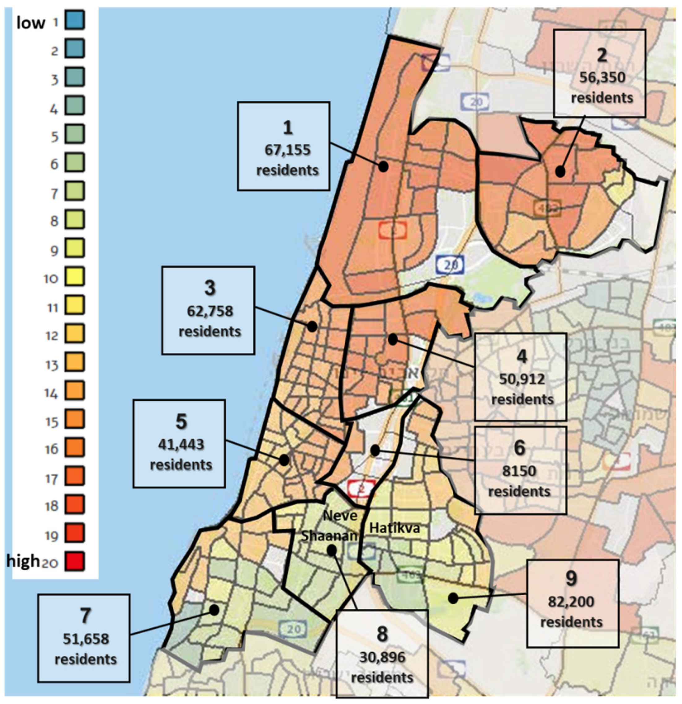
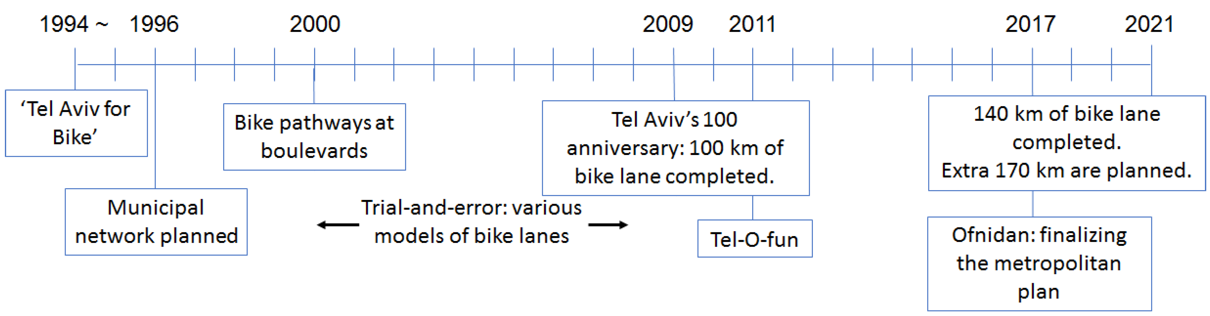
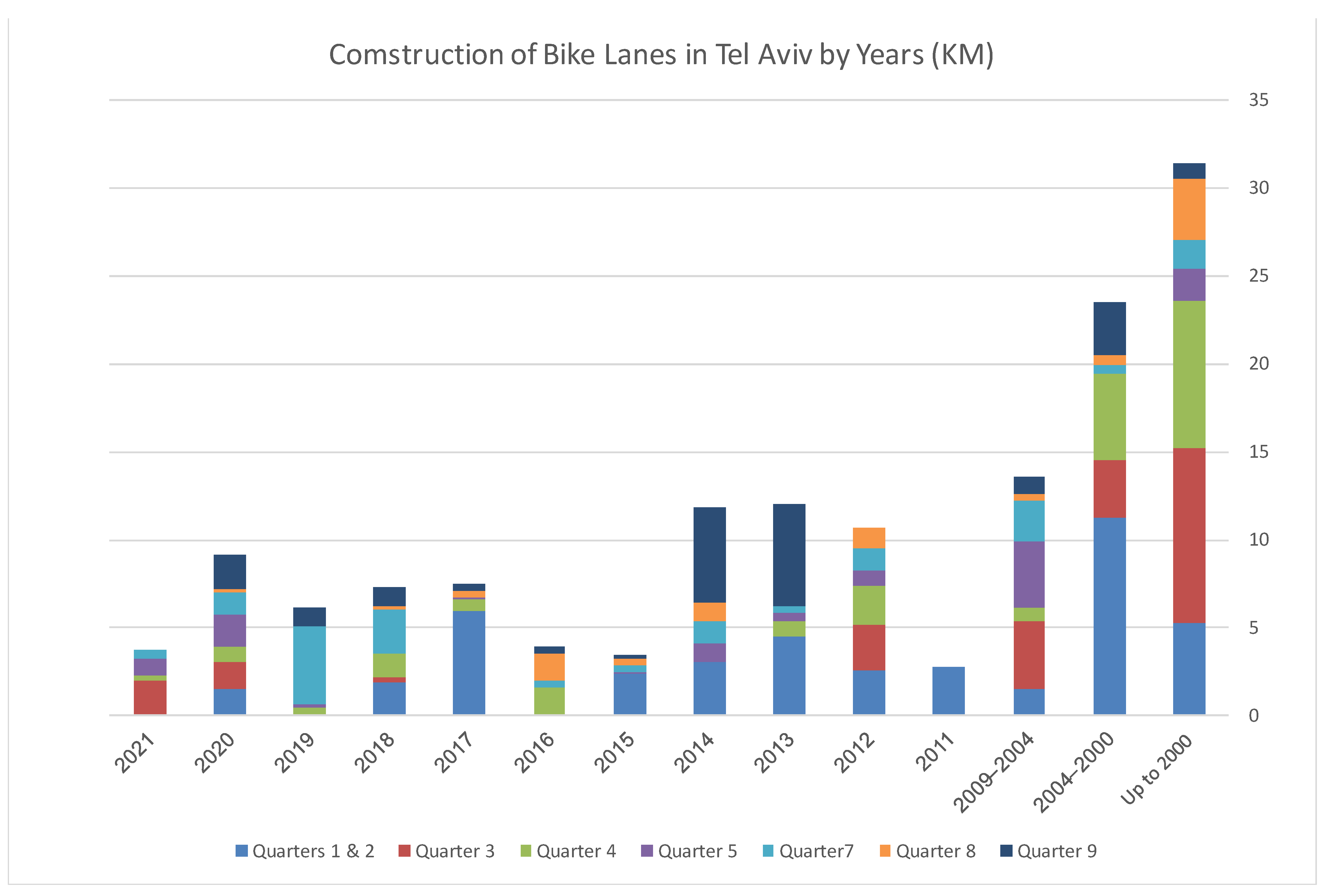
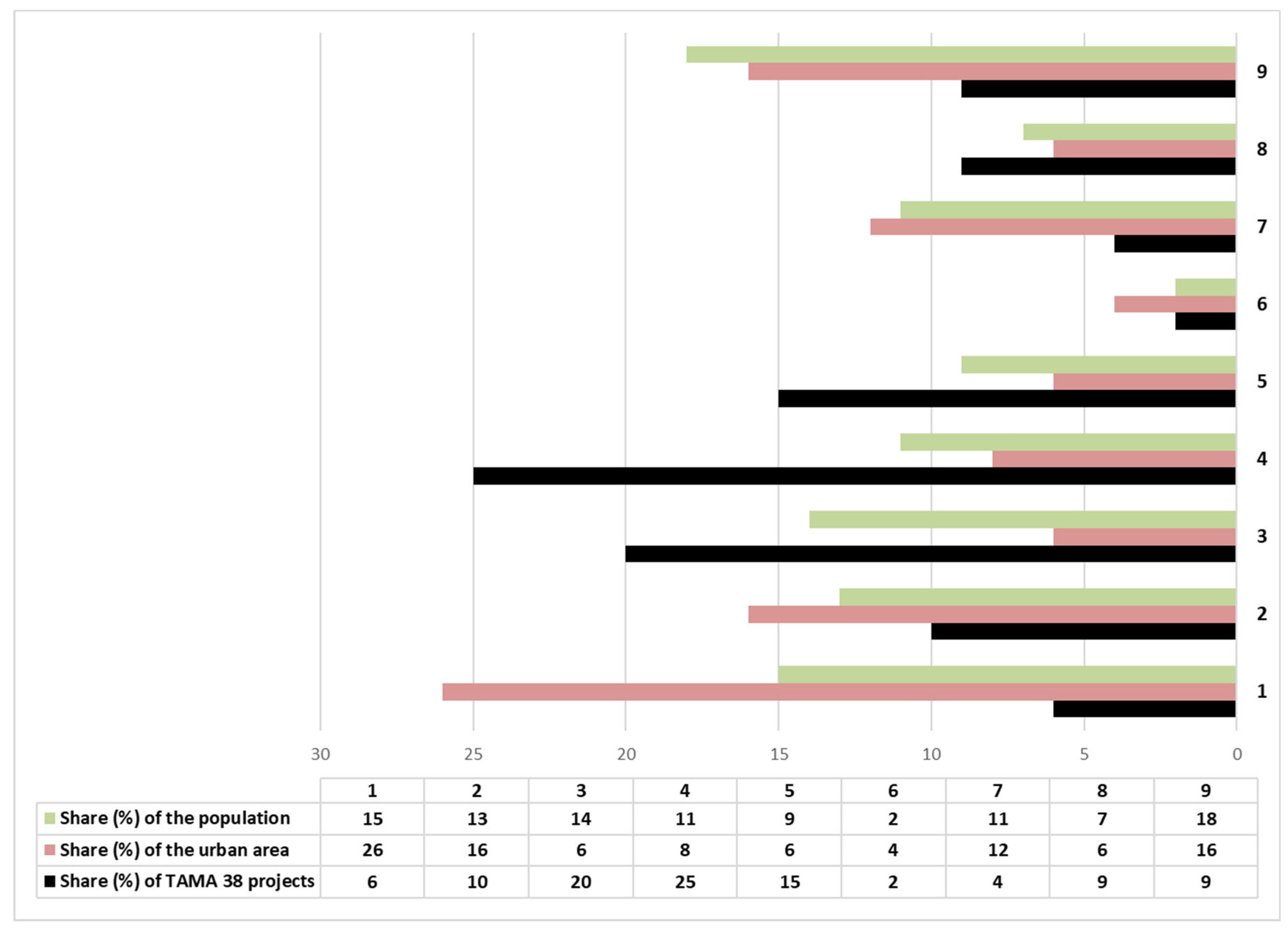
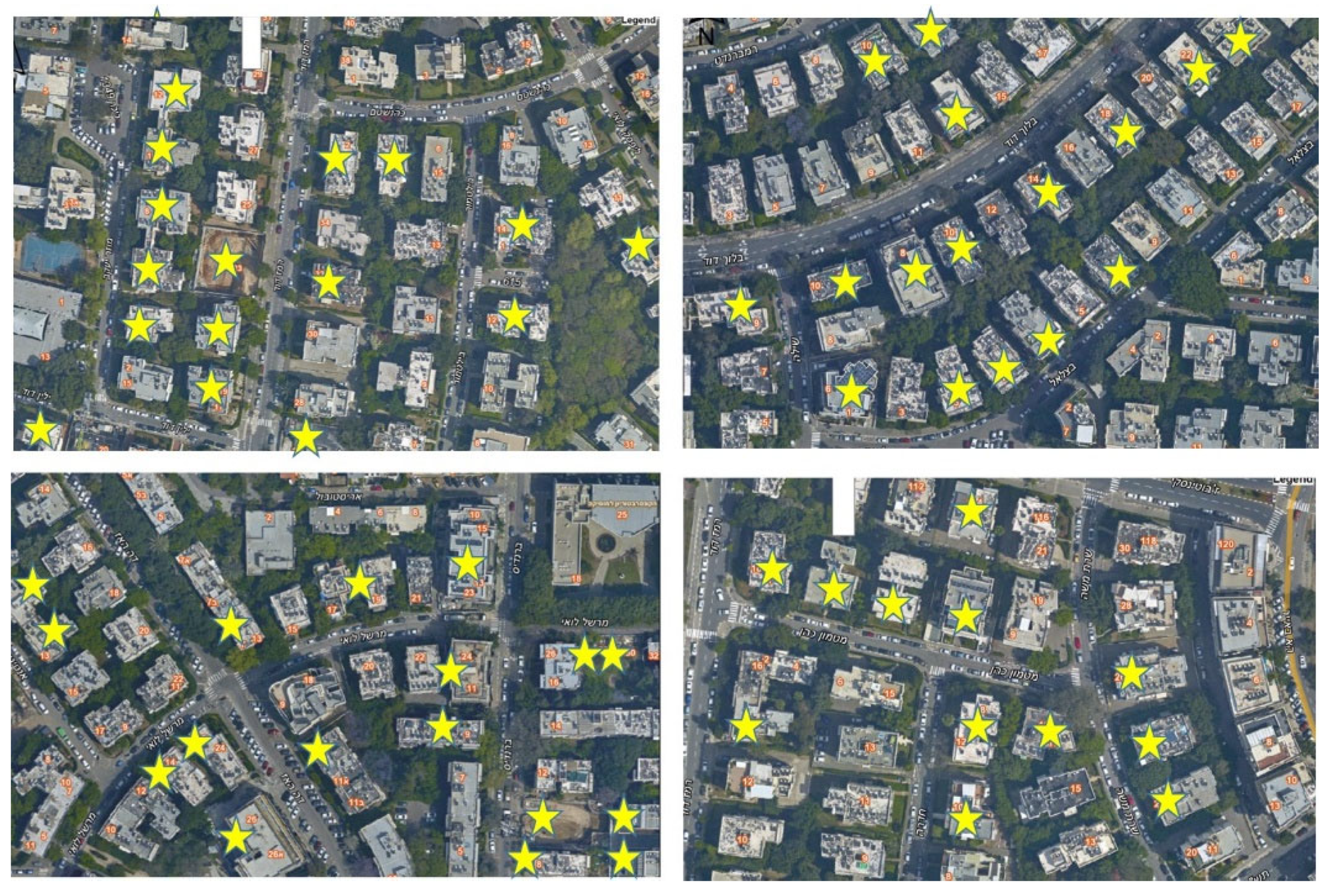
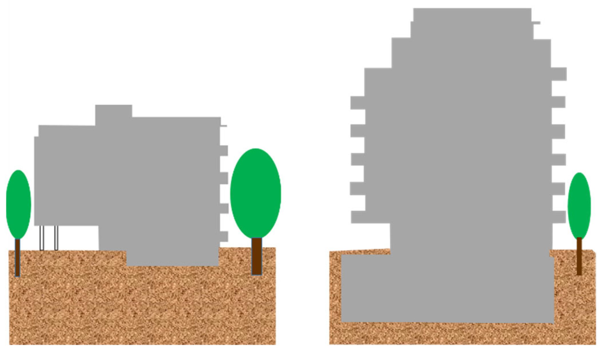
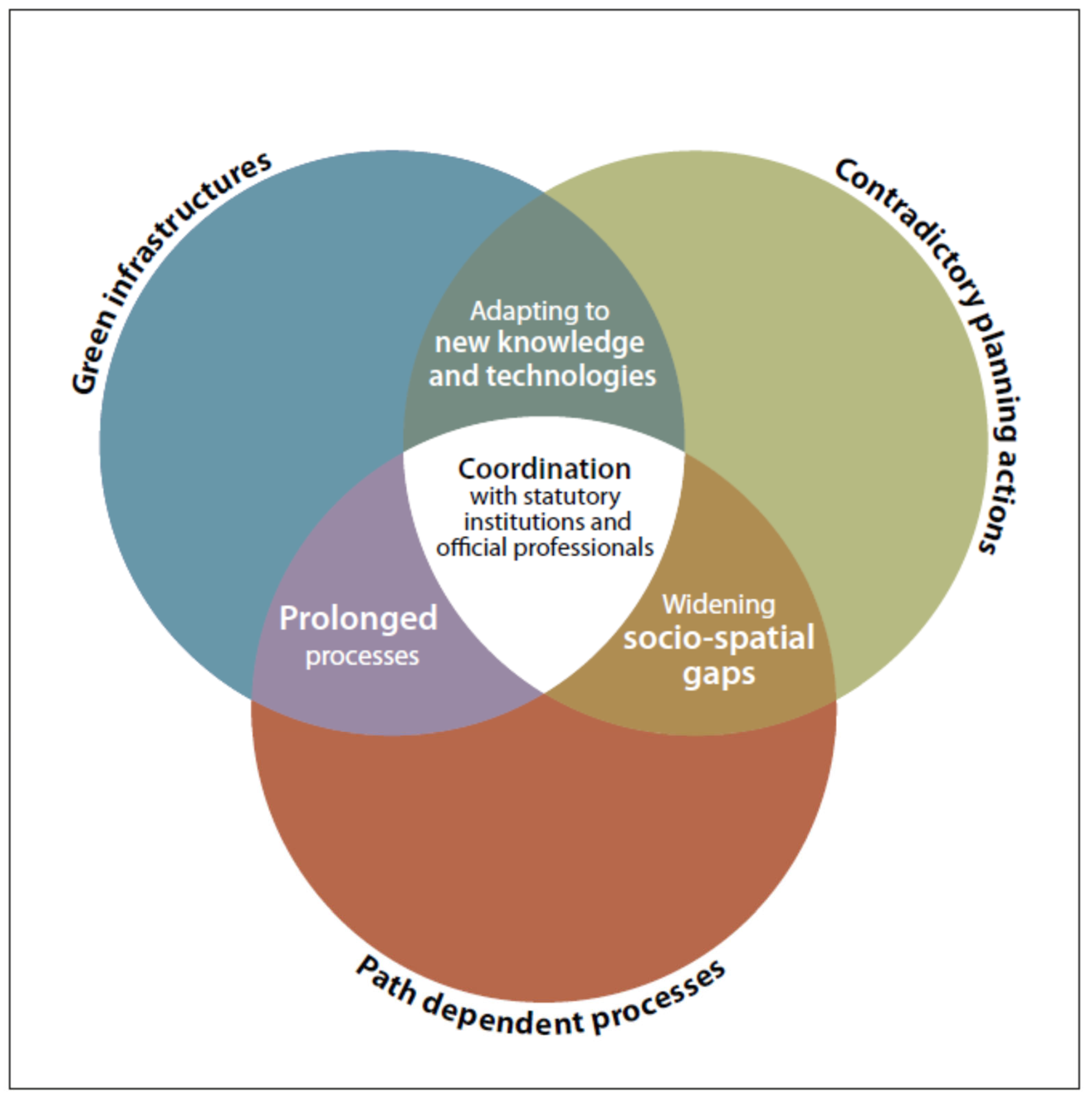
Table 1.
Green policies and rules articulated and adopted by the municipality of Tel Aviv-Jaffa.
| Year | Subject | Statutory Powers |
|---|---|---|
| 2012 | Sustainable “green” building | Obligatory. Based on Israeli regulation for sustainable building. |
| 2015 | Comprehensive urban plan (TA-5000) including environmental instructions | Obligatory instructions for new detailed plans, dealing with: -Preserving urban nature -Limited car parking -Drainage and flood prevention |
| 2016 | Spatial instructions for preserving, displacing, uprooting, and removing trees | Obligatory instructions |
| 2016 | Urban nature | Obligatory zoning defining natural sites for preservation. Non-obligatory policy regarding minimizing pest control and fighting invasive species. |
| 2017 | Subterranean development | Non-obligatory policy paper regarding subterranean development. |
| 2017 | Shade in public spaces | Obligatory and detailed instructions requiring shade in public spaces. |
| 2021 | Preparing for climate change | A detailed index and policy instruction paper regarding the following subjects: -Mitigating emissions and reducing energy consumption in transportation and buildings -Reducing urban heat islands -Managing urban water -Minimizing tree uprooting -Managing drainage and preventing floods |
Table 2.
Vehicles involved in road accidents at Tel Aviv-Jaffa, by type of vehicle. Along with the impressive decline in road accidents, note the emerging rate of “other” vehicles since 2010, and the share of bicycles, electric bikes and electric scooters (marked by gray background) in accidents.
Table 2.
Vehicles involved in road accidents at Tel Aviv-Jaffa, by type of vehicle. Along with the impressive decline in road accidents, note the emerging rate of “other” vehicles since 2010, and the share of bicycles, electric bikes and electric scooters (marked by gray background) in accidents.
| Year | Absolute Numbers | Percentage | ||||||
|---|---|---|---|---|---|---|---|---|
| Private Cars | Trucks, Buses, and Minibuses | Motorcycles | Bicycles | Electric Bicycles | Electric Scooters | Other | ||
| 1990 | 6172 | 59.5 | 14.0 | 14.4 | - | - | - | 12.0 |
| 1995 | 7085 | 51.0 | 18.7 | 18.6 | 3.1 | - | - | 8.6 |
| 1997 | 8433 | 54.6 | 17.3 | 19.6 | 2.3 | - | - | 6.1 |
| 2000 | 5742 | 57.1 | 15.1 | 19.1 | 2.0 | - | - | 6.7 |
| 2005 | 4378 | 56.8 | 14.5 | 18.6 | 2.1 | - | - | 8.0 |
| 2006 | 4391 | 56.8 | 14.2 | 19.4 | 2.0 | - | - | 7.6 |
| 2007 | 4327 | 55.2 | 14.2 | 21.1 | 1.9 | - | - | 7.7 |
| 2008 | 4952 | 54.3 | 13.1 | 23.2 | 2.8 | - | - | 6.7 |
| 2009 | 4155 | 54.1 | 11.2 | 25.3 | 2.7 | - | - | 6.6 |
| 2010 | 3404 | 52.8 | 11.4 | 24.7 | 2.7 | - | - | 8.3 |
| 2011 | 2996 | 52.2 | 11.2 | 22.9 | 2.7 | - | - | 11.0 |
| 2012 | 2362 | 54.4 | 10.8 | 20.3 | 3.2 | - | - | 11.3 |
| 2013 | 2531 | 52.0 | 11.3 | 19.8 | 4.0 | - | - | 12.9 |
| 2014 | 2231 | 52.5 | 9.9 | 19.1 | 3.9 | - | - | 14.5 |
| 2015 | 2720 | 50.7 | 9.0 | 21.5 | 3.0 | - | - | 15.8 |
| 2016 | 2360 | 51.3 | 8.3 | 20.8 | 3.4 | - | - | 16.1 |
| 2017 | 2646 | 47.4 | 8.3 | 24.0 | 3.4 | 5.4 | 0.5 | 10.9 |
| 2018 | 2095 | 49.5 | 9.2 | 20.7 | 2.1 | 4.7 | 1.7 | 12.1 |
| 2019 | 2131 | 47.6 | 10.6 | 21.4 | 2.6 | 5.1 | 3.3 | 9.5 |
Publisher’s Note: MDPI stays neutral with regard to jurisdictional claims in published maps and institutional affiliations. |
© 2021 by the authors. Licensee MDPI, Basel, Switzerland. This article is an open access article distributed under the terms and conditions of the Creative Commons Attribution (CC BY) license (https://creativecommons.org/licenses/by/4.0/).
Share and Cite
MDPI and ACS Style
Alfasi, N.; Margalit, T. Toward the Sustainable Metropolis: The Challenge of Planning Regulation. Sustainability 2021, 13, 8189. https://0-doi-org.brum.beds.ac.uk/10.3390/su13158189
AMA Style
Alfasi N, Margalit T. Toward the Sustainable Metropolis: The Challenge of Planning Regulation. Sustainability. 2021; 13(15):8189. https://0-doi-org.brum.beds.ac.uk/10.3390/su13158189
Chicago/Turabian StyleAlfasi, Nurit, and Talia Margalit. 2021. "Toward the Sustainable Metropolis: The Challenge of Planning Regulation" Sustainability 13, no. 15: 8189. https://0-doi-org.brum.beds.ac.uk/10.3390/su13158189
Note that from the first issue of 2016, this journal uses article numbers instead of page numbers. See further details here.