
Mapping Mangrove Opportunities with Open Access Data: A Case Study for Bangladesh

 ,
,
Abstract
:
1. Introduction
2. Theoretical Background
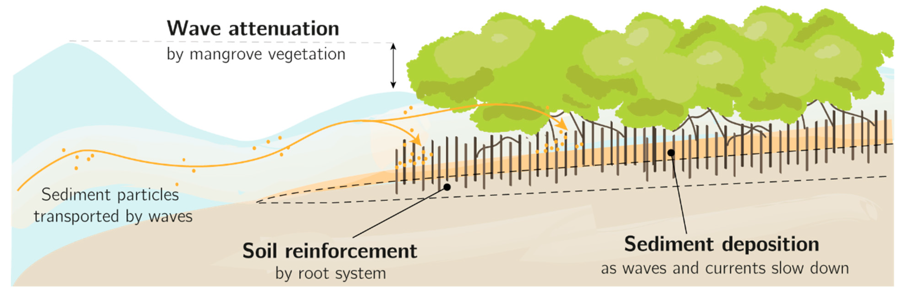
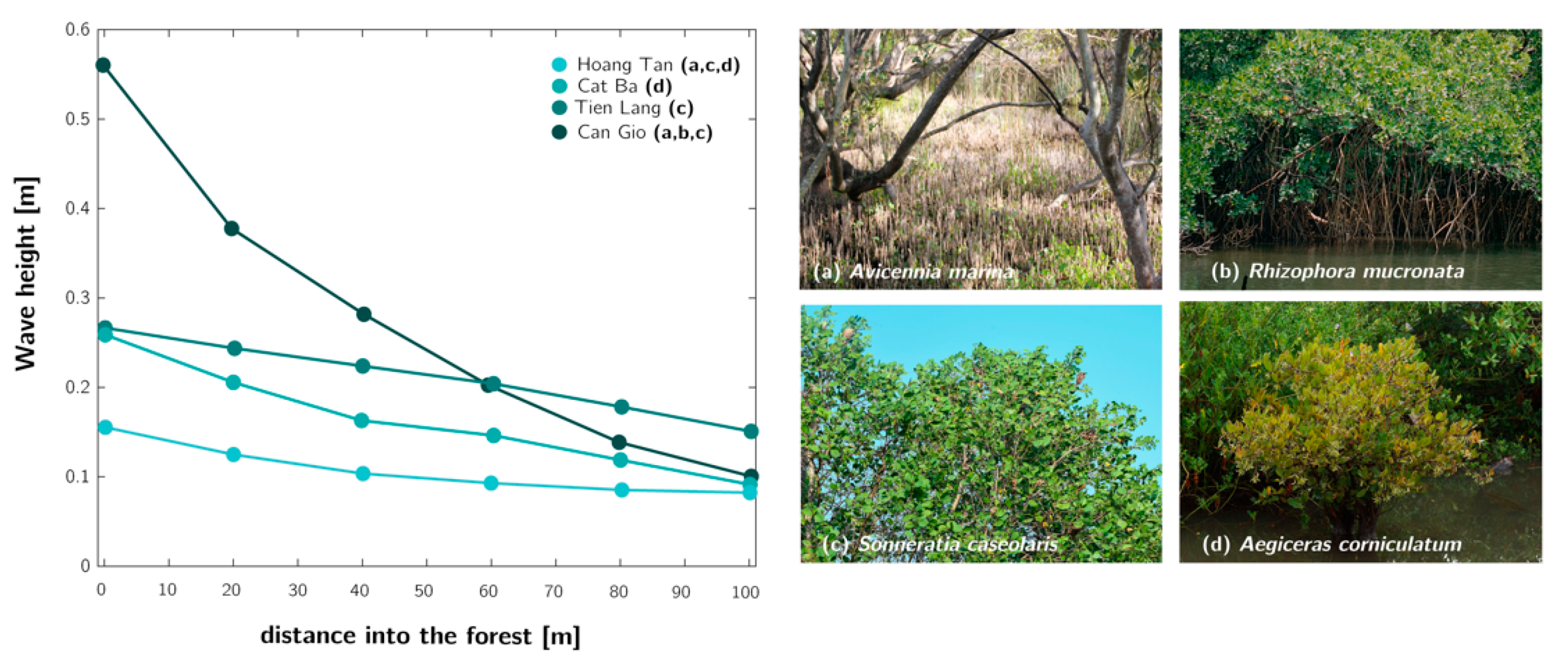
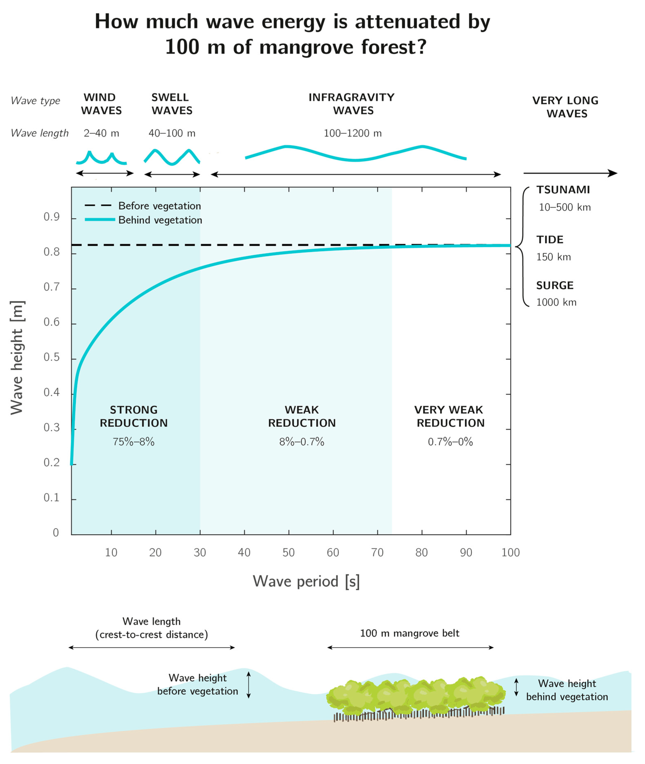
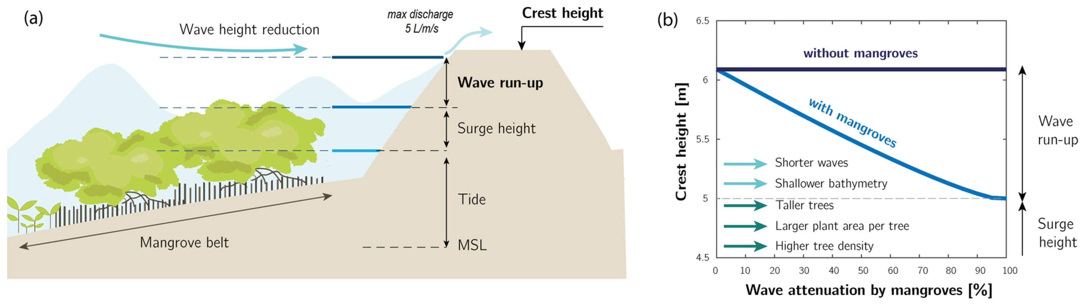
2.1. Coastal Protection by Mangroves in Bangladesh
2.2. Finding Suitable Locations for Mangroves Foreshores
3. Materials and Methods
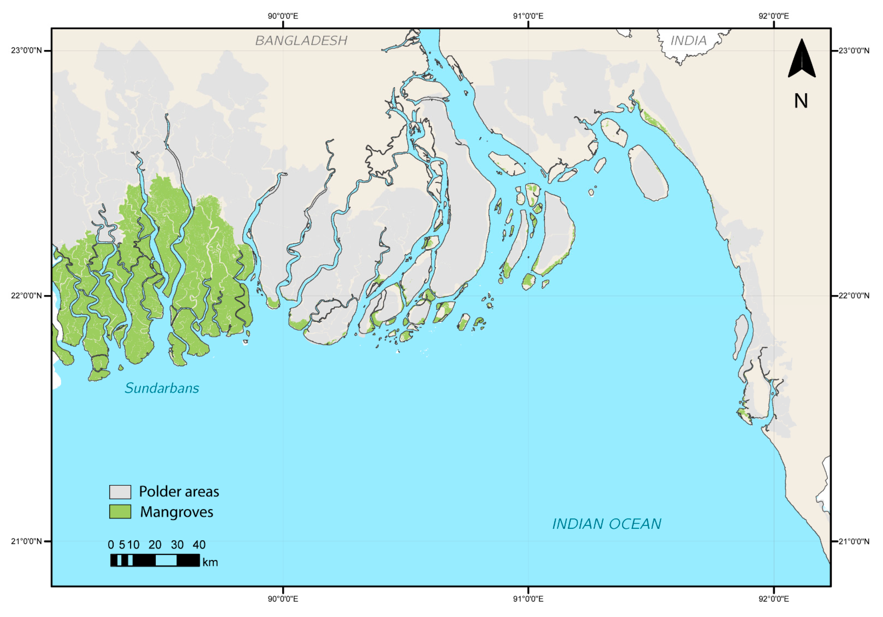
3.1. Description of the Study Area
3.2. Open Access Databases
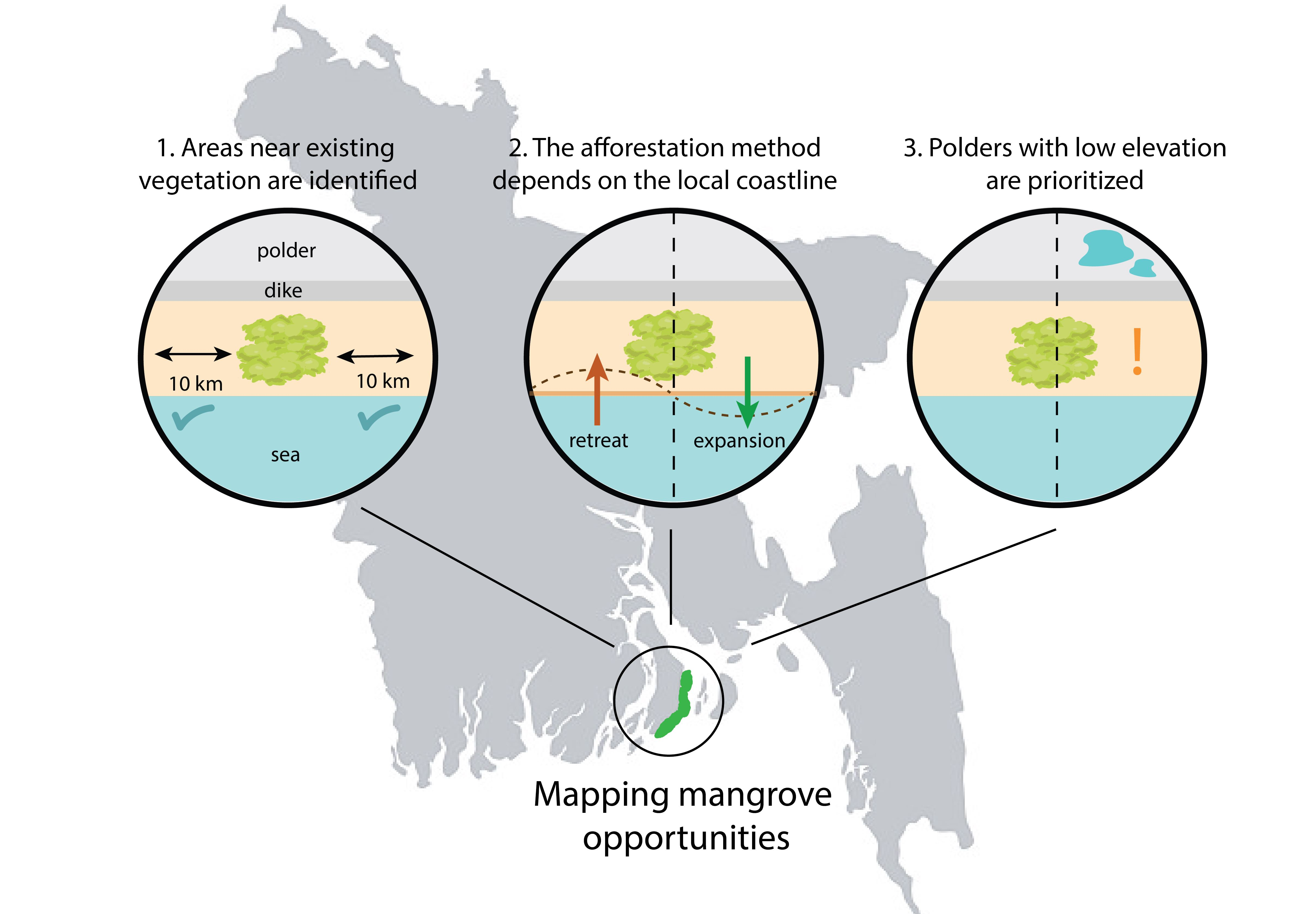
3.3. Screening Methodology
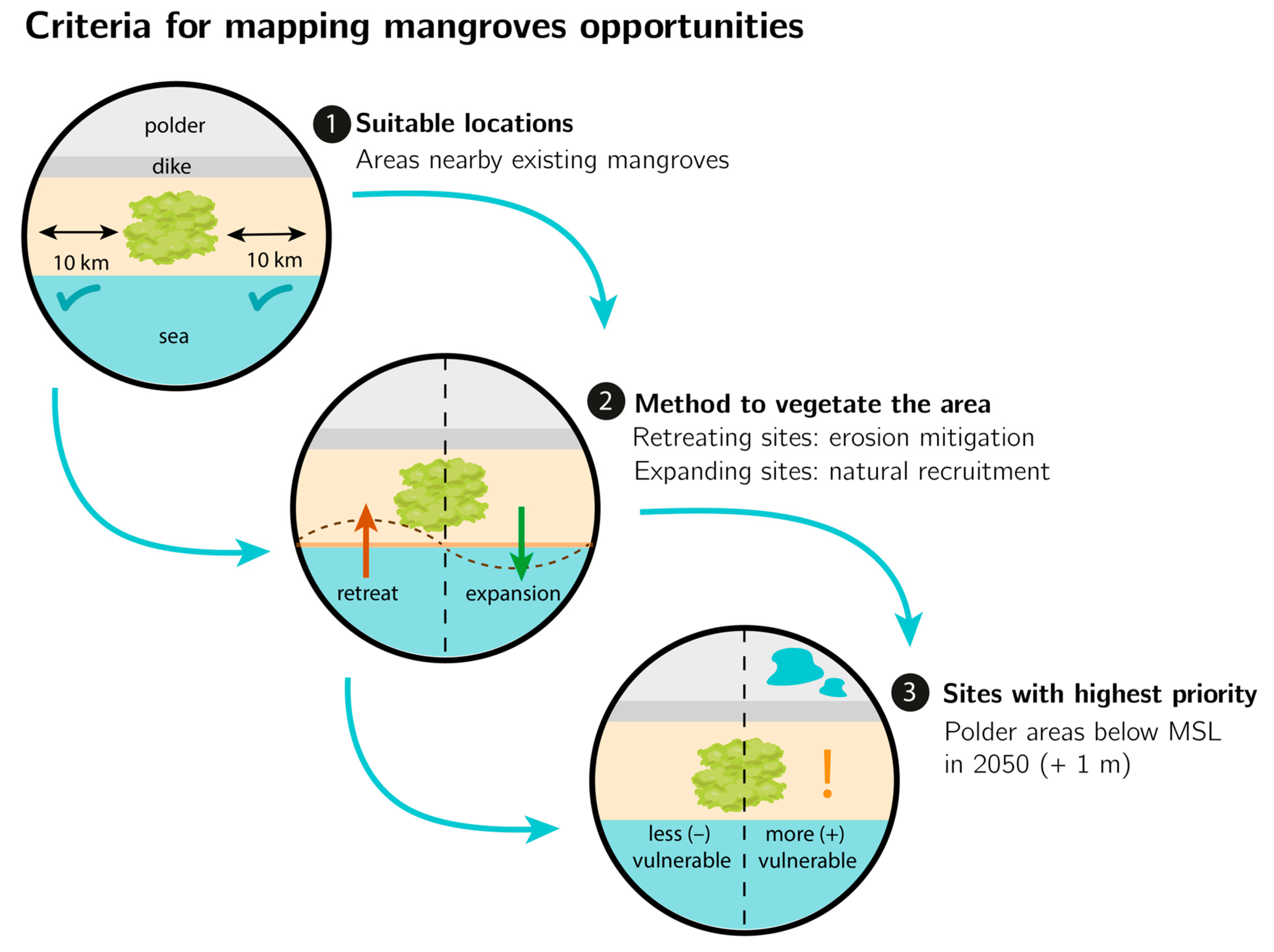
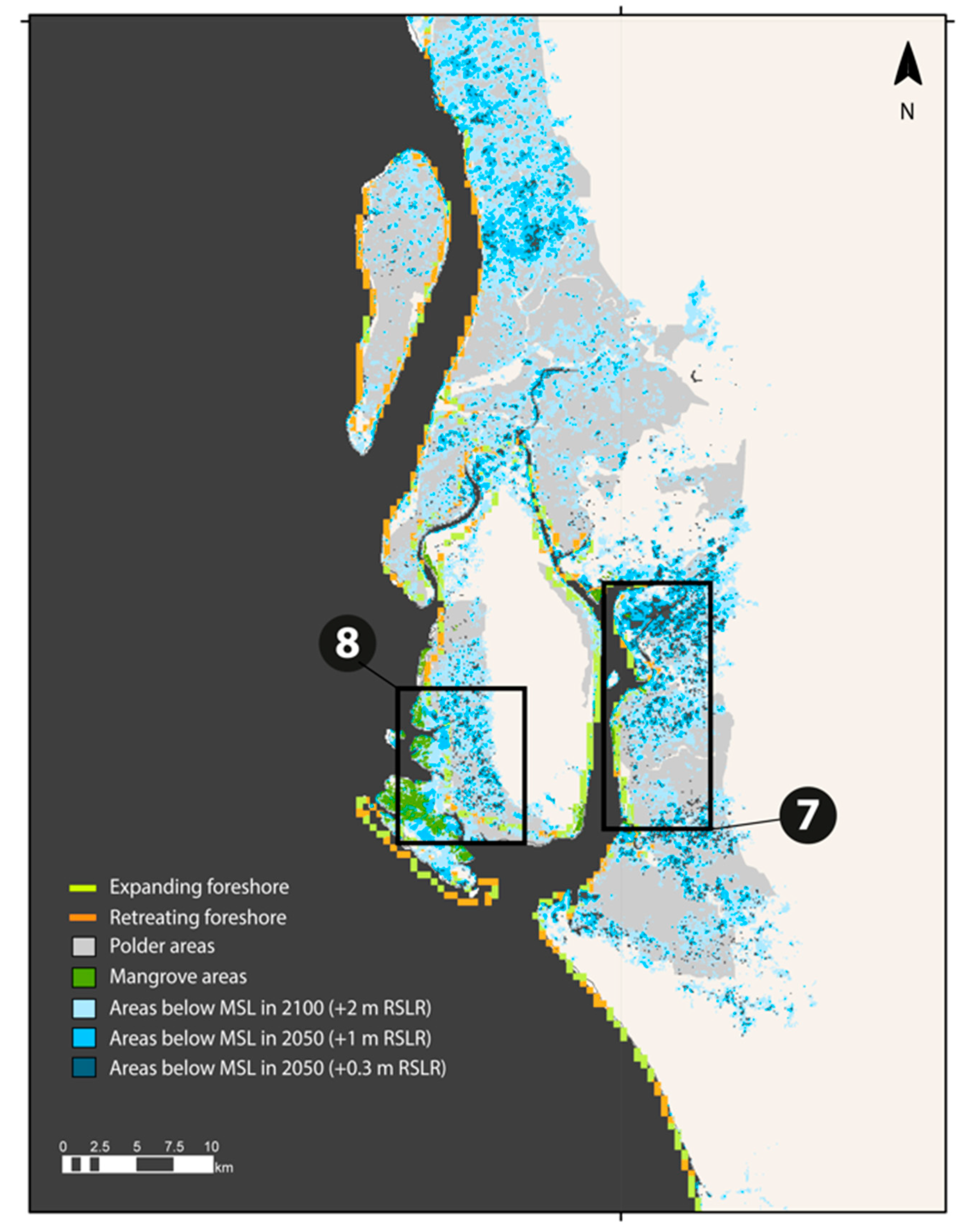
- Suitability of a site as potential habitat: we considered sites within 10 km of existing mangroves as potentially suitable for colonization. This limit was based on dispersal distances observed by Clarke [56] for Avicennia marina seedlings. In practice, the dispersal distances will vary between mangrove species, and will depend on the local hydrodynamic processes. However, this value provides a preliminary indication of the areas that could recruit naturally. The existing mangrove sites were obtained from the maps by the Global Forest Watch (Table 1).
- Method needed to implement vegetation: the techniques needed to vegetate a site were based on the rates of coastline change from the Aqua-monitor tool [52]. We assumed that natural colonization would happen at locations with expanding coastlines near existing mangroves, and if seedling availability was low, or natural processes were too slow compared to coastal protection targets, they could be complemented by planting efforts. At sites with retreating coastlines, erosion mitigation measures, such as bamboo structures or nourishments, would be needed.
- Prioritization criterion based on vulnerability: we evaluated the level of priority based on the flooding risk of landward areas using the ground elevation measurements from CoastalDEM® [51], and 3 scenarios of relative sea level rise (RSLR) from IPCC [55]: +0.3 m (expected value in 2050), +1 m (worst case scenario in 2050), and +2 m (worst case scenario in 2100). Since polders comprise inhabited areas and valuable assets, their protection was prioritized compared to non-polder areas. Moreover, polders are blocked from any sediment input by the tide, which means that, unlike unembanked areas, they have no mechanisms to accrete and keep up with rising sea levels. Polders that would be below MSL in the RSLR scenario of +1 m in 2050 were given the highest flooding risk, and we prioritized vegetated foreshores seawards of them.
4. Results
5. Discussion
6. Conclusions
Author Contributions
Funding
Institutional Review Board Statement
Informed Consent Statement
Data Availability Statement
Acknowledgments
Conflicts of Interest
References
- Eckstein, D.; Künzel, V.; Schäfer, L.; Winges, M. Global Climate Risk Index 2019; Germanwatch e.V: Bonn, Germany, 2020. [Google Scholar]
- Khan, R.S. Cyclone Hazard in Bangladesh; Community Development Library: Dhaka, Bangladesh; National States Geographic Information Council: Dhaka, Bangladesh, 1992; pp. 86–102. [Google Scholar]
- Jakobsen, F.; Zeaul Hoque, A.K.M.; Paudyal, G.N.; Bhuiyan, M.S. Evaluation of the short-term processes forcing the monsoon river floods in Bangladesh. Water Int. 2005, 30, 389–399. [Google Scholar] [CrossRef]
- Staveren, M.F.; Warner, J.F.; Khan, M.S.A. Bringing in the tides. From closing down to opening up delta polders via Tidal River management in the southwest delta of Bangladesh. Water Policy 2017, 19, 147–164. [Google Scholar] [CrossRef]
- Paul, B.K. Why relatively fewer people died? The case of Bangladesh’s Cyclone Sidr. Nat. Hazards 2009, 50, 289–304. [Google Scholar] [CrossRef]
- Nishat, A. Review of Present Activities and State of Art of the Coastal Areas of Bangladesh. Coastal Area Resource Development and Management Part II; Coastal Area Resource Development and Management Association (CARDMA): Dhaka, Bangladesh, 1988; pp. 23–35. [Google Scholar]
- Naz, F.; Buisson, M.C. Multiple actors, conflicting roles and perverse incentives: The case of poor operation and maintenance of coastal polders in Bangladesh. In Proceedings of the CPWF, GBDC, WLE Conference on Revitalizing the Ganges Coastal Zone: Turning Science into Policy and Practices, Dhaka, Bangladesh, 21–23 October 2015; pp. 147–161. [Google Scholar]
- Awal, M.A.; Islam, A.F.M. Water Logging in south-western coastal region of Bangladesh: Causes and consequences and people’s response. Asian J. Geogr. Res. 2020, 3, 9–28. [Google Scholar]
- Islam, A.S.; Bala, S.K.; Hussain, M.A.; Rahman, M.M. Performance of coastal structures during Cyclone Sidr. Nat. Hazards Rev. 2011, 12, 3. [Google Scholar] [CrossRef]
- World Bank. Project Appraisal Document of People's Republic of Bangladesh Coastal Embankment Improvement Project—Phase 1 (CEIP-1) (P128276); Report No. PAD432; World Bank: Washington, DC, USA, 2013. [Google Scholar]
- Mazda, Y.; Wolanski, E.; King, B. Drag force due to vegetation in mangrove swamps. Mangroves Salt Marshes 1997, 1, 193–199. [Google Scholar] [CrossRef]
- Bao, T. Effect of mangrove forest structures on wave attenuation in coastal Vietnam. Oceanologia 2011, 53, 807–818. [Google Scholar]
- Massel, S.R.; Furukawa, K.; Brinkman, R.M. Surface wave propagation in mangrove forests. Fluid Dyn. Res. 1999, 24, 219. [Google Scholar] [CrossRef]
- Horstman, E.M.; Dohmen-Janssen, C.M.; Narra, P.M.F.; van den Berg, N.J.F.; Siemerink, M.; Hulscher, S.J.M.H. Wave attenuation in mangroves: A quantitative approach to field observations. Coast. Eng. 2014, 94, 47–62. [Google Scholar] [CrossRef]
- Krauss, K.W.; Doyle, T.W.; Doyle, T.J.; Swarzenski, C.M.; From, A.S.; Day, R.H.; Conner, W.H. Water level observations in mangrove swamps during two hurricanes in Florida. Wetlands 2009, 29, 142–149. [Google Scholar] [CrossRef]
- Montgomery, J.M.; Bryan, K.R.; Mullarney, J.C.; Horstman, E.M. Attenuation of storm surges by coastal mangroves. Geophys. Res. Lett. 2020, 46, 2680–2689. [Google Scholar] [CrossRef] [Green Version]
- Karim, M.F.; Mimura, N. Impacts of climate change and sea-level rise on cyclonic storm surge floods in Bangladesh. Glob. Environ. Chang. 2009, 18, 490–500. [Google Scholar] [CrossRef]
- Zaman, S.; Mondal, M.S. Risk-based determination of polder height against storm surge Hazard in the south-west coastal area of Bangladesh. Prog. Disaster Sci. 2020, 8, 100131. [Google Scholar] [CrossRef]
- Vuik, V.; van Vuren, S.; Borsje, B.W.; van Wesenbeeck, B.K.; Jonkman, S.N. Assessing safety of nature-based flood defenses: Dealing with extremes and uncertainties. Coast. Eng. 2018, 18, 47–64. [Google Scholar] [CrossRef] [Green Version]
- Vuik, V.; Borsje, B.W.; Willemsen, P.W.J.M.; Jonkman, S.N. Salt marshes for flood risk reduction: Quantifying long-term effectiveness and life-cycle costs. Ocean. Coast. Manag. 2019, 171, 96–110. [Google Scholar] [CrossRef] [Green Version]
- Saenger, P.; Siddiqi, N.A. Land from the sea: The mangrove afforestation program of Bangladesh. Ocean. Coast. Manag. 1993, 20, 23–39. [Google Scholar] [CrossRef] [Green Version]
- Worthington, T.A.; Spalding, M.D. Mangrove restoration potential: A global map highlighting a critical opportunity. Apollo 2018. [Google Scholar] [CrossRef]
- Iftekhar, M.S.; Saenger, P. Vegetation dynamics in the Bangladesh Sundarbans mangroves: A review of forest inventories. Wetl. Ecol. Manag. 2008, 16, 291–312. [Google Scholar] [CrossRef]
- Nicholls, R.J.; Hoozemans, F.M.J.; Marchand, M. Increasing flood risk and wetland losses due to global sea-level rise: Regional and global analyses. Glob. Environ. Chang. 1999, 9, S69–S87. [Google Scholar] [CrossRef]
- Maza, M.; Lara, J.J.; Losada, I.J. Experimental analysis of wave attenuation and drag forces in a realistic fringe Rhizophora mangrove forest. Adv. Water Resour. 2019, 131, 1033376. [Google Scholar] [CrossRef]
- Trampanya, U. Mangroves and sediment Dynamics along the Coasts of Southern Thailand. Ph.D. Thesis, Wageningen University and Research, Wageningen, The Netherlands, 2006. [Google Scholar]
- Winterwerp, J.C.; Albers, T.; Anthony, E.J.; Friess, D.A.; Gijón Mancheño, A.; Moseley, K.; Muhari, A.; Naipal, S.; Noordermeer, J.; Oost, A.; et al. Managing erosion of mangrove-mud coasts with permeable dams—Lessons learned. Ecol. Eng. 2020, 158, 1060. [Google Scholar] [CrossRef]
- Méndez, F.J.; Losada, I.J. An empirical model to estimate the propagation of random breaking and nonbreaking waves over vegetation fields. Coast. Eng. 2004, 51, 103–118. [Google Scholar] [CrossRef]
- Suzuki, T. Wave Dissipation over Vegetation Fields. Ph.D. Thesis, Delft University of Technology, Delft, The Netherlands, 2011. [Google Scholar]
- Tanaka, N.; Sasaki, Y.; Mowjood, M.I.M.; Jinadasa, K.B.S.N.; Homchuen, S. Coastal vegetation structures and their functions in tsunami protection: Experience of the recent Indian Ocean tsunami. Landsc. Ecol. Eng. 2007, 3, 33–45. [Google Scholar] [CrossRef]
- Tanaka, N. Effectiveness and limitations of vegetation bioshield in coast for tsunami disaster mitigation. In The Tsunami Threat: Research and Technology; Intech: London, UK, 2011. [Google Scholar]
- Kathiresan, K.; Rajendran, N. Coastal mangrove forests mitigated tsunami. Estuar. Coast. Shelf Sci. 2005, 65, 601–606. [Google Scholar] [CrossRef]
- Montgomery, J.M.; Bryan, K.R.; Horstman, E.M.; Mullarney, J.C. Attenuation of tides and surges by mangroves: Contrasting case studies from New Zealand. Water 2018, 10, 1119. [Google Scholar] [CrossRef] [Green Version]
- Bangladesh University of Engineering and Technology; Bangladesh Institute of Development Studies. Multi-Purpose Cyclone Shelter Project; Summary Report; Bangladesh University of Engineering and Technology, Bangladesh Institute of Development Studies: Dhaka, Bangladesh, 1993. [Google Scholar]
- Alongi, D.M. Present state and future of the world’s mangrove forests. Environ. Conserv. 2002, 29, 331–349. [Google Scholar] [CrossRef] [Green Version]
- Lewis, R.R., III. Methods and criteria for successful mangrove forest restoration. In Coastal Wetlands: An Integrated Ecosystem Approach; Perillo, G., Wolanski, E., Cahoon, D., Hopkinson, C., Eds.; Elsevier: Amsterdam, The Netherlands, 2009; p. 787. ISBN 978-0-444-53103-2. [Google Scholar]
- Vovides, A.G.; Bashan, Y.; López-Portillo, J.; Guevara, R. Nitrogen fixation in preserved, reforested, naturally regenerated and impaired mangroves as an indicator of functional restoration in mangroves in an arid region of Mexico. Restor. Ecol. 2011, 19, 236–244. [Google Scholar] [CrossRef]
- Kairo, J.G.; Dahdouh-Guebas, F.; Bosire, J.; Koedam, N. Restoration and management of man- grove systems—A lesson for and from the East African region. S. Afr. J. Bot. 2001, 6, 383–389. [Google Scholar] [CrossRef] [Green Version]
- Snedaker, S.C. Mangrove species zonation. In Tasks for Vegetation Science: Contributions to the Ecology of Halophytes; Springer: New York, NY, USA, 1982; Volume 2, pp. 111–125. [Google Scholar]
- Ellison, A.M.; Mukherjee, B.B.; Karim, A. Testing patterns of zonation in mangroves: Scale dependence and environmental correlates in the Sundarbans of Bangladesh. J. Ecol. 2000, 88, 813–824. [Google Scholar] [CrossRef]
- Lopez-Portillo, J.L.; Lewis, R.R., III; Saenger, P.; Rovai, A.S. Mangrove forest restoration and rehabilitation. In Mangrove Ecosystems: A Global Biogeographic Perspective; Springer: Cham, Switzerland, 2017. [Google Scholar]
- Winterwerp, J.C.; Borst, W.; Vries, M. Pilot study on the erosion and rehabilitation of a mangrove-mud coast. J. Coast. Res. 2005, 21, 223–230. [Google Scholar] [CrossRef]
- Saintilan, N.; Khan, N.S.; Ashe, E.; Kelleway, J.J.; Rogers, K.; Woodroffe, C.D.; Horton, B.P. Thresholds of mangrove survival under rapid sea level rise. Science 2020, 368, 1118–1121. [Google Scholar] [CrossRef]
- Bolts, W. Carte du Bengale et de ses Dépendances; Universität Bern: Bern, Switzerland, 1775. [Google Scholar]
- Curtis, S.J. Working plan for the forests of the sundarbans division for the period from 1 April 1931 to 31 March 1951. In Description of the Compartments and Their Histories; Government of Bengal: Kolkata, India, 1933; Volume 3. [Google Scholar]
- Blasco, F. Outlines of ecology, botany and forestry of the mangals of the Indian subcontinent. In Wet Coastal Ecosystems, Ecosystems of the World; Chapman, V.J., Ed.; Elsevier: Amsterdam, The Netherlands, 1977; Volume 1, pp. 241–260. [Google Scholar]
- Iftekhar, M.S.; Islam, M.R. Degeneration of Bangladesh Sundarbans mangroves: A management issue. Int. Forest. Rev. 2004, 6, 123–135. [Google Scholar] [CrossRef]
- Schmitt, K.; Albers, T.; Pham, T.; Dinh, S. Site-specific and integrated adaptation to climate change in the coastal mangrove zone of Soc Trang Province, Viet Nam. J. Coast. Conserv. 2013, 17, 545–558. [Google Scholar] [CrossRef] [Green Version]
- Bagchi, K. The Ganges Delta; University of Calcutta: Calcutta, India, 1944. [Google Scholar]
- Dasgupta, S.; Huq, M.; Huq Khan, Z.; Zahid Ahmed, M.M.; Mukherjee, N.; Khan, M.F.; Pandey, K. Vulnerability of Bangladesh to Cyclones in a Changing Climate: Potential Damages and Adaptation Costs; Policy Research Working Paper 5280; The World Bank Development Research Group, Environment and Energy Team: Washington, DC, USA, 2010. [Google Scholar]
- Kulp, S.A.; Strauss, B.H. New elevation data triple estimates of global vulnerability to sea-level rise and coastal flooding. Nat. Commun. 2019, 10, 4844. [Google Scholar] [CrossRef] [PubMed] [Green Version]
- Luijendijk, A.; Hagenaars, G.; Ranasinghe, R.; Baart, F.; Donchyts, G.; Aaarninkof, S. The State of the World’s Beaches. Sci. Rep. 2018, 8, 6641. [Google Scholar] [CrossRef] [PubMed]
- Murray, N.J.; Phinn, S.R.; De Witt, M.; Ferrari, R.; Johnston, R.; Lyons, M.B.; Clinton, N.; Thau, D.; Fuller, R.A. Global distribution and trajectory of tidal flats. Nature 2019, 565, 222–225. [Google Scholar] [CrossRef] [PubMed]
- Bricheno, L.M.; Wolf, J.; Islam, S. Tidal intrusion within a mega delta: An unstructured grid modelling approach. Estuarine, Coast. Shelf Sci. 2016, 182, 12–26. [Google Scholar] [CrossRef] [Green Version]
- IPCC. Climate Change 2007: Impacts, Adaptation and Vulnerability: Summary for Policymakers. Working Group II Contribution to the Intergovernmental Panel on Climate Change Fourth Assessment Report; IPCC: Geneva, Switzerland, 2007. [Google Scholar]
- Clarke, P.J. Dispersal of grey mangrove (Avicennia marina) propagules in southeastern Australia. Aquat. Bot. 1993, 45, 195–204. [Google Scholar] [CrossRef]
- Van der Meer, J.W.; Allsop, N.W.H.; Bruce, T.; De Rouck, J.; Kortenhaus, A.; Pullen, T.; Schuttrumpf, H.; Troch, P.; Zanuttigh, B. Manual on Wave overtopping of Sea Defences and Related Structures. An Overtopping Manual Largely Based on European Research, but for Worldwide Application. EurOtop. 2018. Available online: http://www.overtopping-manual.com/eurotop/downloads/ (accessed on 1 May 2021).
- Quartel, S.; Kroon, A.; Augustinus, P.; Santen, P.; Tri, N.H. Wave attenuation in coastal mangroves in the Red River Delta, Vietnam. J. Asian Earth Sci. 2007, 29, 576–584. [Google Scholar] [CrossRef]
- McIvor, A.; Möller, I.; Spencer, T.; Spalding, M. Reduction of Wind and Swell Waves by Mangroves; Natural Coastal Protection Series Report 1; Wetlands International: Wageningen, The Netherlands; The Nature Conservancy: Arlington, VA, USA, 2012; p. 27. [Google Scholar]
- Barbier, E.B. Capitalizing on Nature: Ecosystems as Natural Assets; Cambridge University Press: Cambridge, UK, 2011. [Google Scholar]
- Balke, T.; Bouma, T.J.; Horstman, T.M.; Webb, E.L.; Erftemeijer, P.L.A.; Herman, P.J.M. Windows of opportunity: Thresholds to mangrove seedling establishment on tidal flats. MEPS 2011, 440, 1–9. [Google Scholar] [CrossRef] [Green Version]
- Cannon, D.; Kibler, K.; Donnelly, M.; McClenachan, G.; Walters, L.; Roddenberry, A.; Phagan, J. Hydrodynamic habitat thresholds for mangrove vegetation on the shorelines of a microtidal estuarine lagoon. Ecol. Eng. 2020, 158, 106070. [Google Scholar] [CrossRef]
- Best, Ü.S.N.; Van der Wegen, M.; Dijkstra, J.; Willemsen, P.W.J.M.; Borsje, B.W.; Roelvink, D.J.A. Do salt marshes survive sea level rise? Modelling wave action, morphodynamics and vegetation dynamics. Environ. Model. Softw. 2018, 109, 152–166. [Google Scholar] [CrossRef]
- Lewis, R.R.; Brown, B. Ecological Mangrove rehabilitation—A Field Manual for Practitioners; Version 3; Mangrove Action Project Indonesia: Jakarta, Indonesia; Blue Forests Project: Jakarta, Indonesia; Canadian International Development Agency: Ottawa, ON, Canada; OXFAM: Nairobi, Kenya, 2014; p. 275. [Google Scholar]
- Van Hespen, R.; Hu, Z.; Peng, Y.; Borsje, B.W.; Kleinhans, M.; Ysebaert, T.; Bouma, T.J. Analysis of coastal storm damage resistance in successional mangrove species. Limnol. Oceanogr. 2021, 1–16. [Google Scholar] [CrossRef]
- Whitten, A.J.; Damanik, S.J. Mass defoliation of mangroves in Sumatra, Indonesia. Biotropica 1986, 18, 176. [Google Scholar] [CrossRef]
- Chaturvedi, N. A new alternative host plant of teak defoliator Hyblaea puera (Hyblaeidae: Lepidoptera). J. Bombay Nat. Hist. Soc. 1995, 92, 431. [Google Scholar]
- Chaturvedi, N. Some observations on teak defoliator Hyblaea puera (Lepidoptera: Hyblaeidae) on secondary host plant Avicennia marina. In Proceedings of the National Seminar on Creeks, Estuaries, and Mangroves: Pollution and Conservation, Thane, India, 28–30 November 2002; Quadros, G., Ed.; Banddkar College of Science: Thane, India, 2002; p. 289. [Google Scholar]
- Xie, Y.; Bas, H.; Li, Y.; Shekhar, S. Discovering spatial mixture patterns of interest. In Proceedings of the 28th ACM SIGSPATIAL International Conference on Advances in Geographic Information Systems, Seattle, WA, USA, 3–6 November 2020; pp. 608–617. [Google Scholar]
- Xie, Y.; Shekhar, S.; Li, Y. Statistically-Robust Clustering Techniques for Mapping Spatial Hotspots: A. Survey. arXiv 2021, arXiv:2103.12019. [Google Scholar]
- Jonkman, S.N.; Kok, M.; Vrijling, J.K. Flood risk assessment in the Netherlands: A case study for Dike Ring South Holland. Risk Anal. 2008, 28. [Google Scholar] [CrossRef]


| Dataset Type | Description | Source |
|---|---|---|
| Digital elevation model | CoastalDEM® is a digital elevation model at 90 × 90 m resolution, with a maximum vertical accuracy of −0.29 m. | Kulp and Strauss [51] |
| Coastline change | The Aqua-monitor tool provides the rate of coastline change, and sediment composition (sandy or not sandy), since 2016, in transects every 15 m along the coastline. | Luijendijk [52] |
| Intertidal areas | Global Intertidal provides maps with tidal flat areas until 2016 | Murray [53] |
| Mangrove cover | Global Forest Watch provides the areas of mangrove coverage from 2001 to 2018 (https://www.globalforestwatch.org, accessed on the 1 May 2020) | Global Forest Watch |
| Rivers | Maps of rivers of Bangladesh (https://data.humdata.org/, accessed on the 1 May 2020). | LGED |
| Tidal range | Tidal range measurements | Bricheno [54] |
| Country boundaries and regions | Boundaries of the country and its regions (https://gadm.org, accessed on the 1 May of 2020) | GADM |
| Sea level rise | Global predictions of relative sea level rise | IPCC [55] |
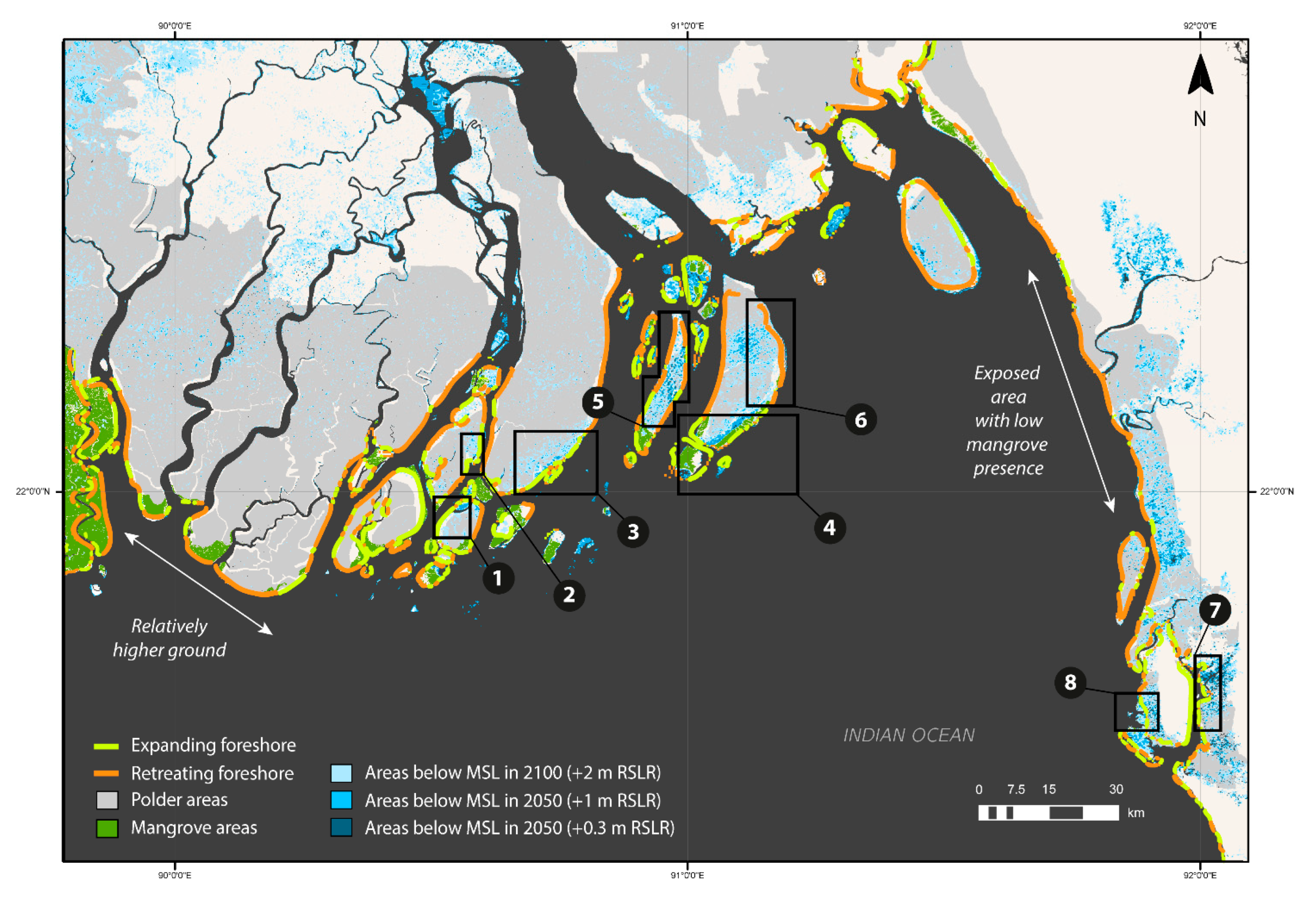
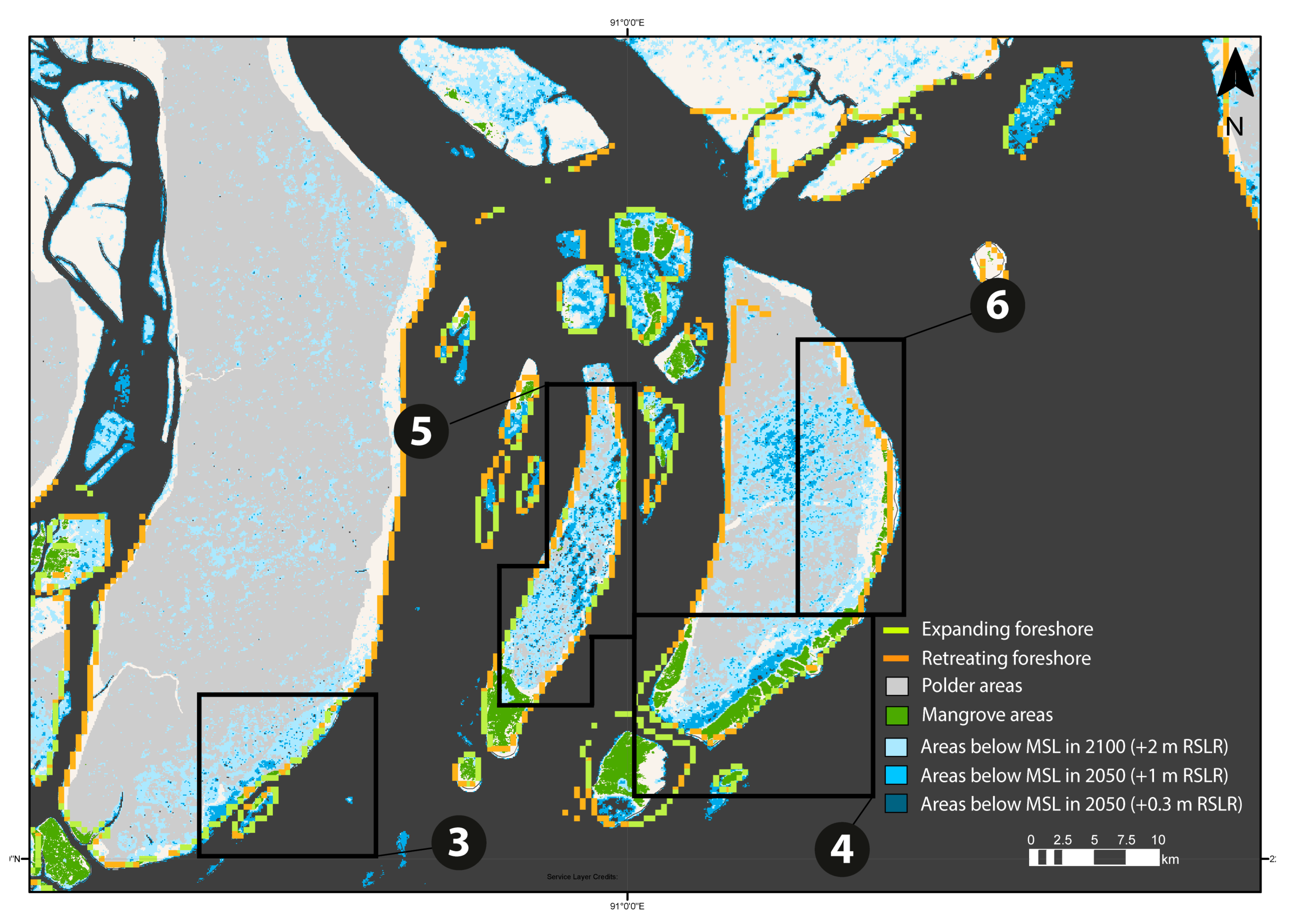
| ID | Location | Polder | Vegetation Implementation Technique |
|---|---|---|---|
| 1 | Galachipa | P55/3 | Natural recruitment/planting |
| 2 | Galachipa | P55/4 | Natural recruitment/planting |
| 3 | Bhola | P56/57 | Natural recruitment/planting |
| 4 | Hatiya South | P73/2 | Natural recruitment/planting |
| 5 | Manpura | P58/1–3 | Erosion mitigation/Natural recruitment/Planting |
| 6 | Hatiya North | P73/1 | Erosion mitigation/Natural recruitment/Planting |
| 7 | Khangona | P66/3 | Natural recruitment/planting |
| 8 | Boro Moheshkhali | P69 | Natural recruitment/planting |
Publisher’s Note: MDPI stays neutral with regard to jurisdictional claims in published maps and institutional affiliations. |
© 2021 by the authors. Licensee MDPI, Basel, Switzerland. This article is an open access article distributed under the terms and conditions of the Creative Commons Attribution (CC BY) license (https://creativecommons.org/licenses/by/4.0/).
Share and Cite
Gijón Mancheño, A.; Herman, P.M.J.; Jonkman, S.N.; Kazi, S.; Urrutia, I.; van Ledden, M. Mapping Mangrove Opportunities with Open Access Data: A Case Study for Bangladesh. Sustainability 2021, 13, 8212. https://0-doi-org.brum.beds.ac.uk/10.3390/su13158212
Gijón Mancheño A, Herman PMJ, Jonkman SN, Kazi S, Urrutia I, van Ledden M. Mapping Mangrove Opportunities with Open Access Data: A Case Study for Bangladesh. Sustainability. 2021; 13(15):8212. https://0-doi-org.brum.beds.ac.uk/10.3390/su13158212
Chicago/Turabian StyleGijón Mancheño, Alejandra, Peter M. J. Herman, Sebastiaan N. Jonkman, Swarna Kazi, Ignacio Urrutia, and Mathijs van Ledden. 2021. "Mapping Mangrove Opportunities with Open Access Data: A Case Study for Bangladesh" Sustainability 13, no. 15: 8212. https://0-doi-org.brum.beds.ac.uk/10.3390/su13158212