1. Introduction
More than half of the global population lives in urban areas [
1]. Urban open spaces provide the large urban population with places for their daily activities, such as recreation, socializing, and exercise. Outdoor activities not only improve the physical and mental health of urban residents [
2], but also increase the city’s vitality [
3]. In addition, longer time spent outside buildings leads to energy saving inside buildings due to reduced usage of indoor appliances such as air conditioners. As a result, it is necessary to attract citizens to urban open spaces by designing and building high-quality outdoor spaces [
4,
5].
However, space itself is a three-dimensional physical void surrounded by entities, with no inherent meaning [
6]. Only when it can accommodate certain human activities and has certain spiritual connotation can it become a meaningful place [
7]. In other words, space is a piece of uncut jade before being equipped with corresponding facilities and given specific functions. Its quality predetermines appropriate activities that can be carried out in the space. Outdoor space quality comprises many factors, such as microclimate, accessibility, openness, etc. Studies have shown that these factors have direct impacts on the usage level of outdoor spaces. For example, Loukaitou-Sideris and Sideris [
8] believe that the accessibility and facilities of sites are the main factor affecting children’s physical activity level. Kaplan et al. found that the openness of space is an important factor affecting users’ preferences. People generally like to carry out activities in a space with a high degree of openness [
9], since human activities in open places are easily noticed. For microclimate, many studies have found that the number of people at a site is directly related to thermal comfort. Sites with higher thermal comfort levels correspond with more people [
10]. Yung et al. [
11] conducted a study concerning the effect of thermal environment; they found that the elderly had a distinctive preference about shade in summer and winter. Therefore, the above factors including accessibility, openness, and microclimate are all important factors contributing to the quality of outdoor space.
It is feasible to model and analyze the above factors of outdoor space quality by computational tools to better aid design and planning. For example, space syntax can be used to quantitatively analyze the accessibility and openness of a site [
12], while computational fluid dynamics (CFD) can provide detailed modeling of the distributions of microclimatic parameters such as air temperature, humidity, wind, and thermal radiation [
13]. By using these computational tools, previous studies analyzed outdoor space quality from single perspectives. For example, Chatzidimitriou and Yannas [
14] assessed the effects of different strategies including geometry, material, soil humidity, vegetation, and water on the microclimate of an urban square and a courtyard in summer by CFD. By comparing the numerical result with wind tunnel experiment, Reiter [
15] showed that the urban wind can be simulated with a high degree of accuracy, and suggested that the tool can be useful for architects and town planners when designing the built environment. Tannous et al. [
16] applied space syntax to analyze the accessibility of public parks, promenades, and other green spaces in Doha, and believe that spatial syntax can be a valuable tool to objectively determine the most optimal location and appropriate size for urban green spaces. Othman et al. [
17] studied the spatial openness and visualization of urban streets by using spatial syntax and GIS tools. They revealed that street space with higher openness and better visibility has higher vitality. The above examples show that digital tools can provide valuable information for the design by offering assessment of the outdoor space quality from single aspects. However, whether a person chooses to use a space is based on his/her perceptions of multiple factors. Some studies have investigated the influence of multiple factors on urban outdoor space usage [
18,
19], but they did not provide a tool to visualize the integrated quality distribution. Currently, no studies integrate the influence of multiple factors. As a result, in order to increase urban vitality and sustainability, it is necessary to quantify the integrated outdoor space quality to provide more comprehensive support during the design, planning, and research of urban open spaces.
In this work, we developed a method to map integrated outdoor space quality and performed a case study in a neighborhood park in Shanghai. A formula to combine accessibility, openness, and microclimate into integrated outdoor space quality was developed based on survey data. The spatial distributions of the three factors of the studied park were generated and integrated into an outdoor space map. Based on the map, several design strategies were proposed to improve the park quality and vitality. This paper details our study.
2. Method
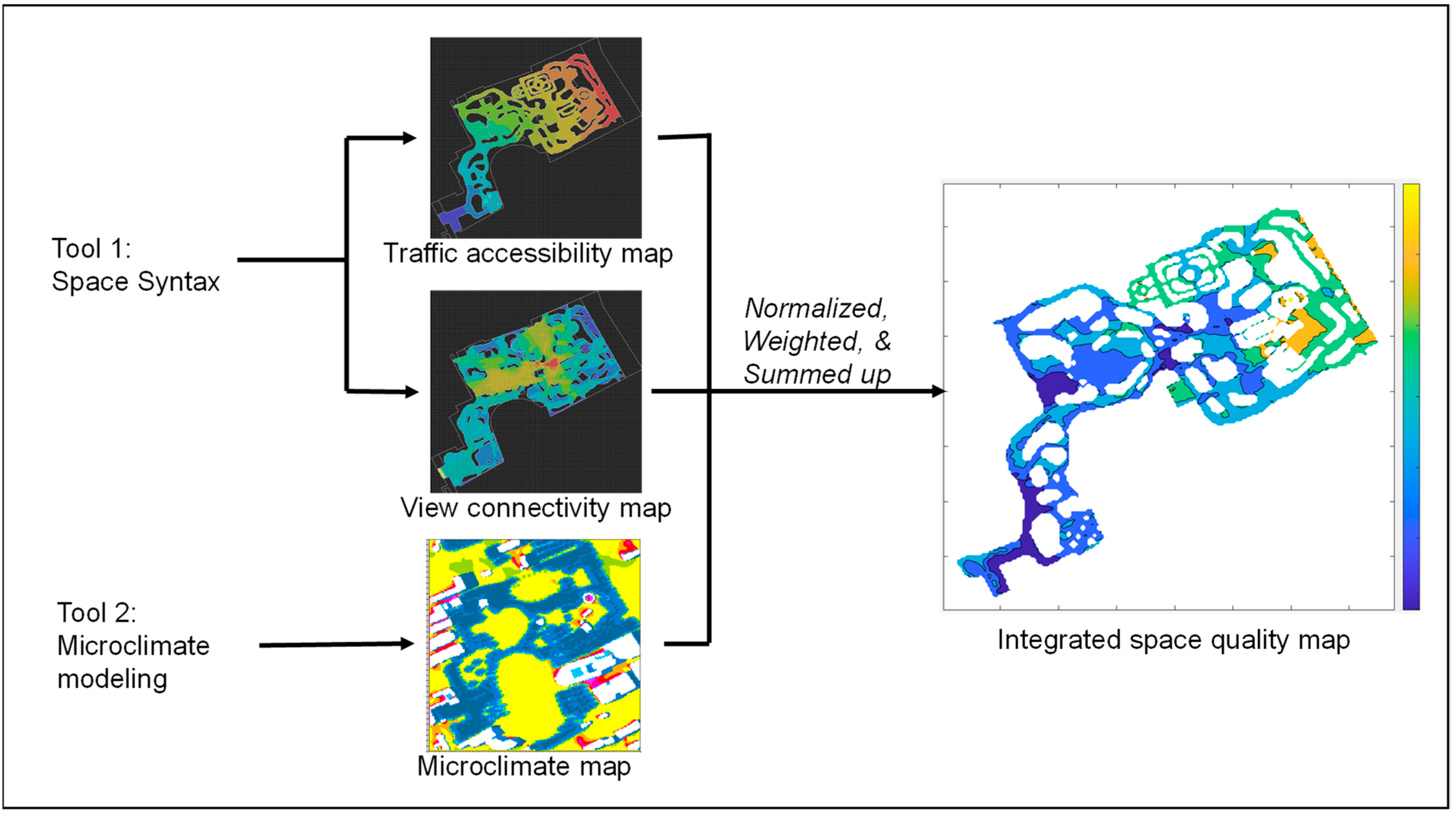
The outdoor space quality map integrates the traffic accessibility, space openness, and microclimate.
Figure 1 shows the generation method of the map. After creating the geometry model, space syntax was used to determine the traffic accessibility and openness, and microclimate modeling was employed to calculate the site microclimate. These analyses were conducted on a digitized grid on the pedestrian level. Each grid cell stored information on accessibility, openness, and microclimate after the calculation. The values of accessibility, openness, and microclimate were normalized, weighted, and summed up to obtain the integrated outdoor space quality index. The map was generated by visualizing the spatial distribution of outdoor space quality index. As a case study, we generated the outdoor space quality map for a neighborhood park in Shanghai. The subsequent contents of this section introduce the studied park; the calculations of its accessibility, openness, microclimate; and the integration of the three factors.
2.1. Studied Park
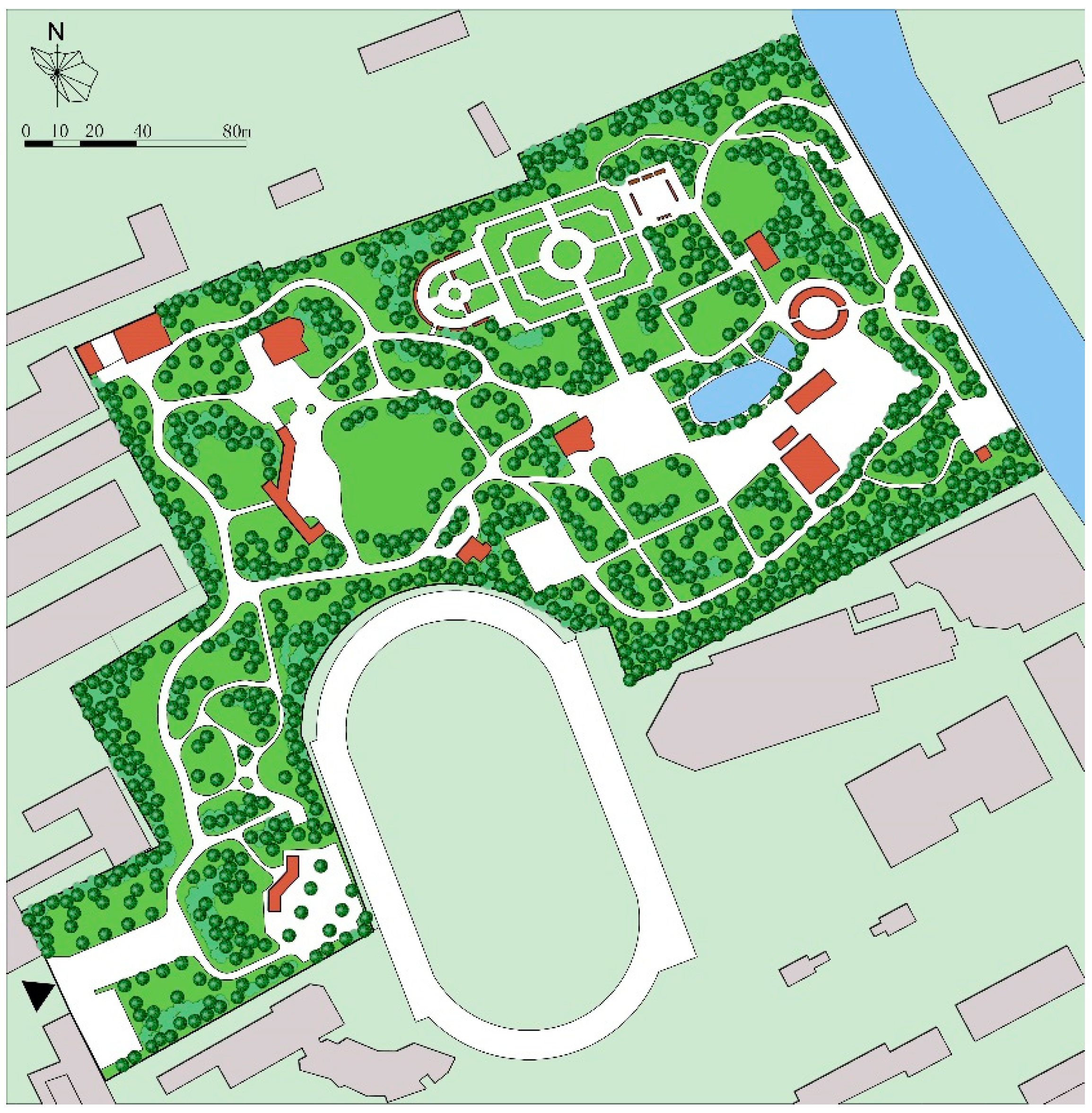
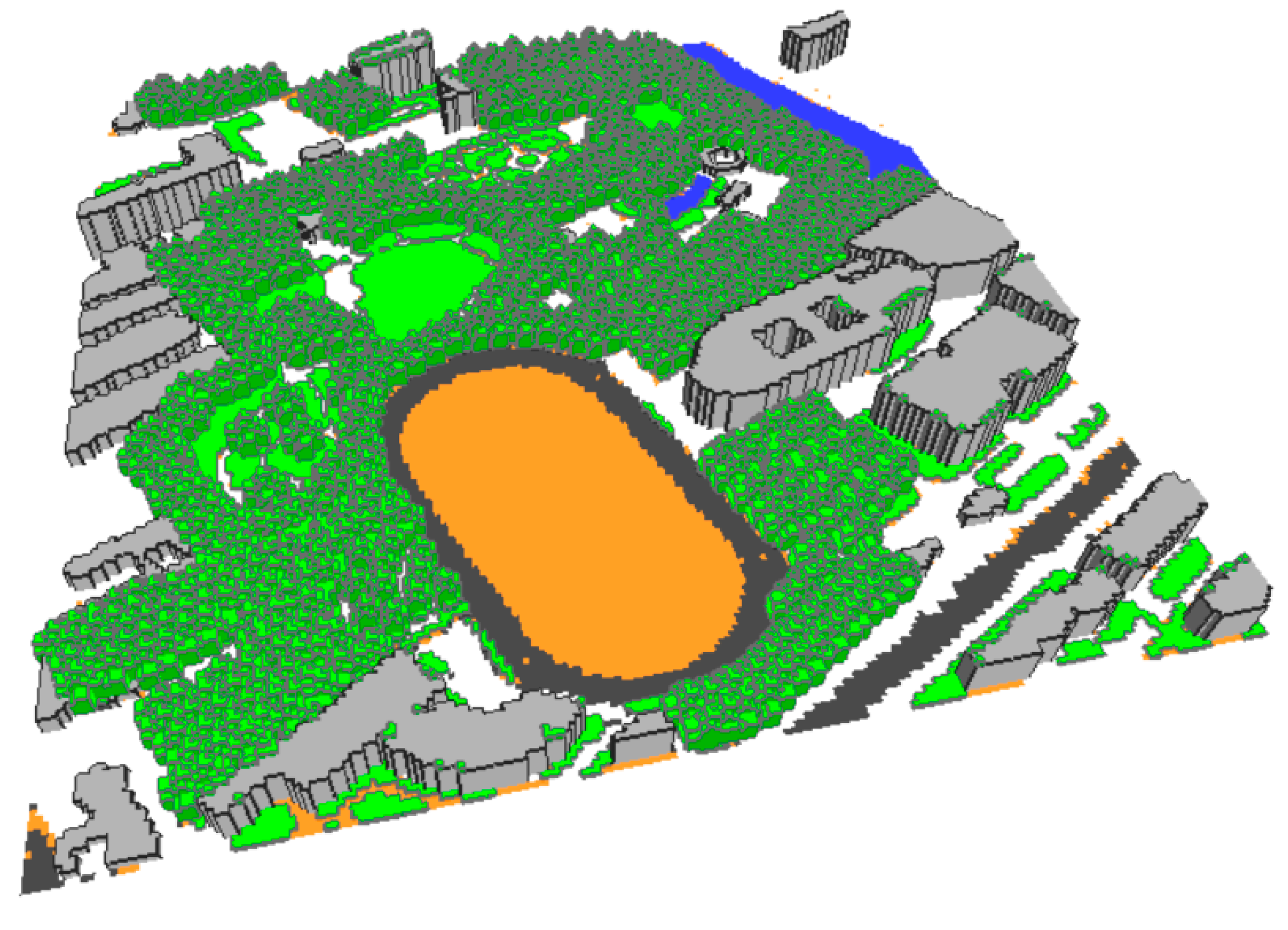
This study focuses on Minhang Park, located in the south of Shanghai, (Latitude: 31.22 N, Longitude: 121.47 E), China. According to the Koppen climate classification, Shanghai was categorized as Cfa (Humid subtropical climate), which is characterized by hot wet summer and cold winter. It was constructed and opened to the public in 1988. The area of the park is 6.06 hectares with a green space ratio of 84%, as shown in
Figure 2. Most visitors of this park are residents from nearby communities, and the elderly represent the major park users. Regular park visitors also include young children accompanied by their families. Teenagers and middle-aged people are not the main users. The types of activities in the park are mainly walking, sitting, chatting, exercising, children’s playing activities, etc.
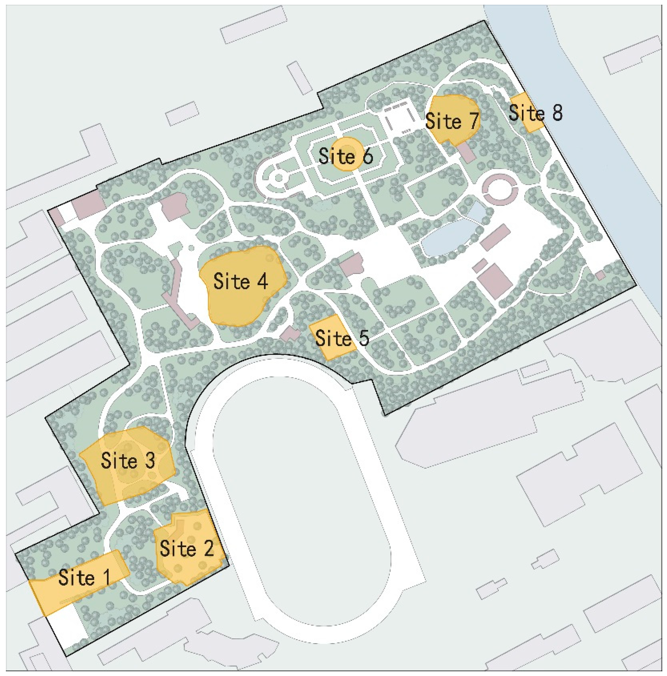
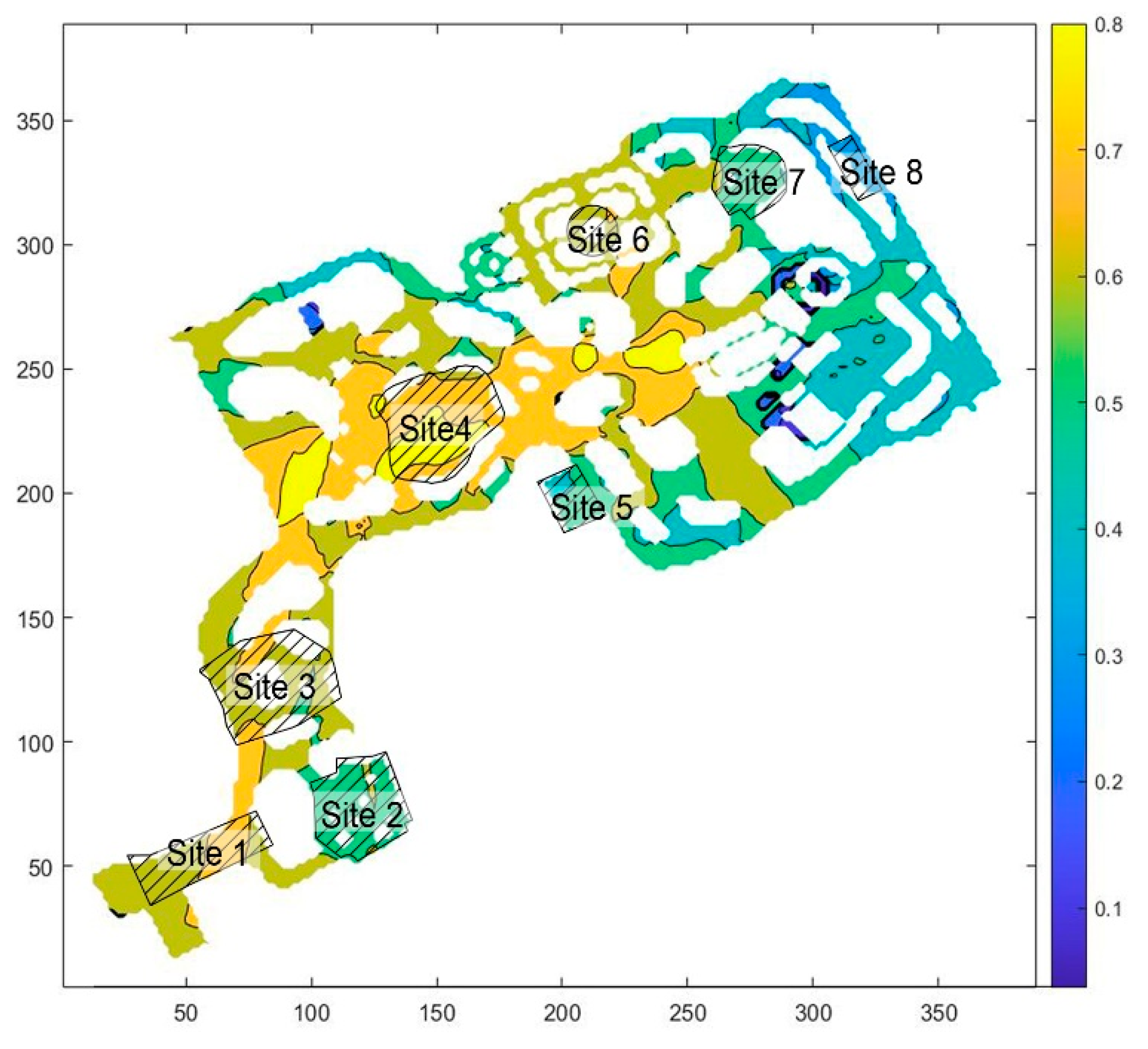
Eight sites were selected in Minhang Park to further compare and analyze spaces with different openness, accessibility, and microclimate conditions, as shown in
Figure 3 and
Table 1. Site 1 is a cement ground close to the only entrance of the park, and is mainly used as a traffic space. Site 2 is close to Site 1 and has many rest seats that can accommodate 72 people at the same time. Tall trees are planted in Site 2, with a high degree of enclosure. Site 3 is a traffic space. Site 4 is a large accessible lawn with some rest facilities. Site 5 is a rectangular space surrounded by trees on three sides. Site 6 is a typical Western-style garden, mainly composed of regular grassland and low shrubs, with high openness. Site 7 is a small accessible lawn surrounded by dense vegetation on three sides and is open from only one side. Site 8 is a small space of hard ground with six chairs, and is the farthest space from the park entrance. The space is narrow with a high degree of enclosure.
2.2. Generating Traffic Accessibility Map
In this study, space syntax was used to generate a traffic accessibility and spatial openness map. The concept of space syntax was developed by Hillier et al. [
20] at University College London using digital technology to quantitatively express the logical relationship between spaces, so as to quantitatively describe the structure of human activity space [
6]. Space syntax has been widely used in spatial analysis in the fields of architecture, urban planning, urban transportation, and landscape architecture [
8,
21,
22,
23]. It is mainly used to study the impact of spatial structure on human activities and social connections, such as the relationship between spatial accessibility, spatial network pattern characteristics, spatial structure, and human activities.
We used the spatial syntax analysis tool Depthmap software [
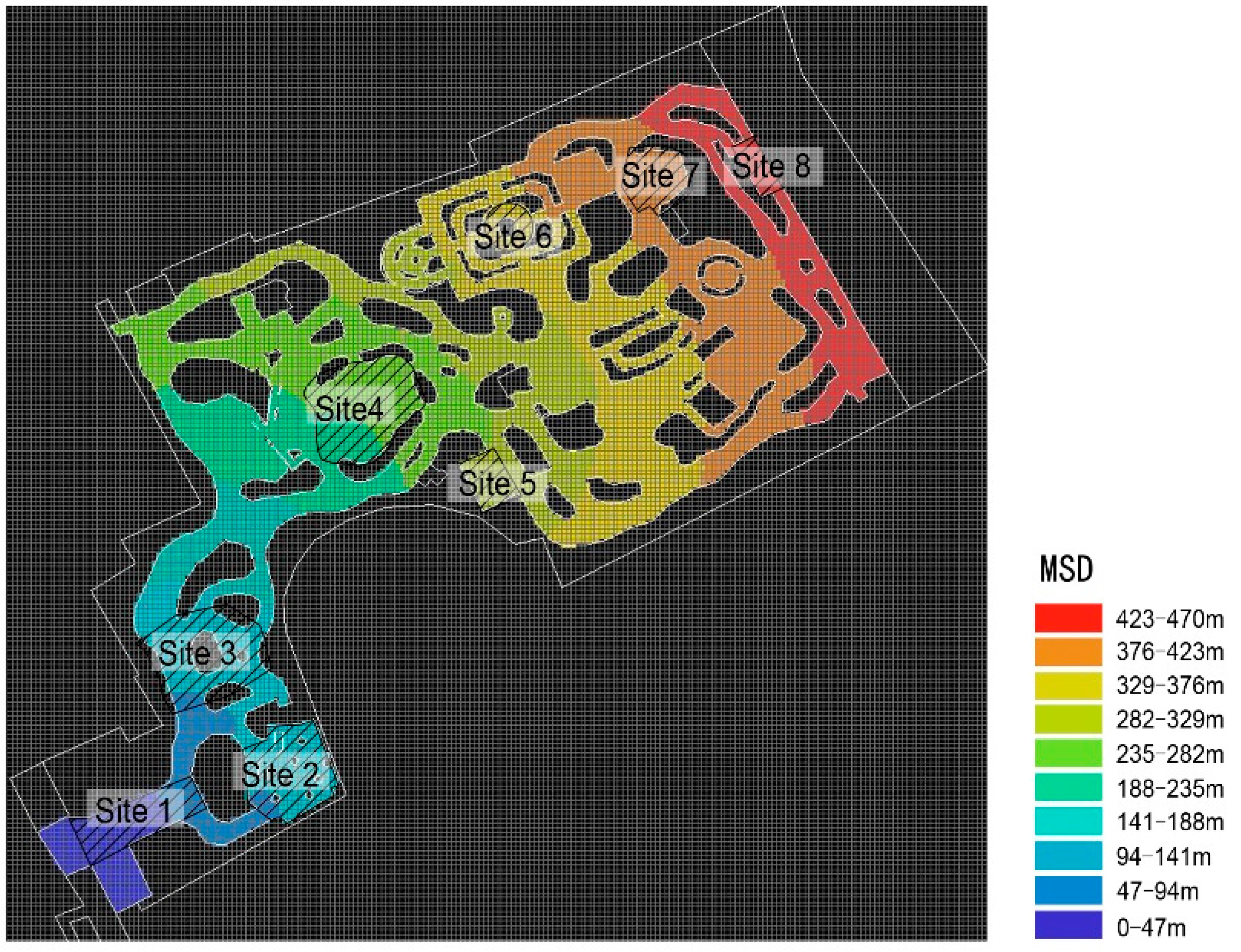
24] to establish a 2D model of Minhang Park (388 m × 388 m) with the size of each grid cell set to 2 m × 2 m (194 × 194 grid cells). Depthmap was also used to generate a traffic accessibility map, which is characterized by metric step depth (MSD). MSD refers to the shortest distance from the starting point to other grid cells. In this case, the starting point is the only entrance of Minhang Park. The shorter the metric distance, the better the traffic accessibility. Please refer to the accessibility map generated in
Figure 4.
2.3. Generating Openness Map
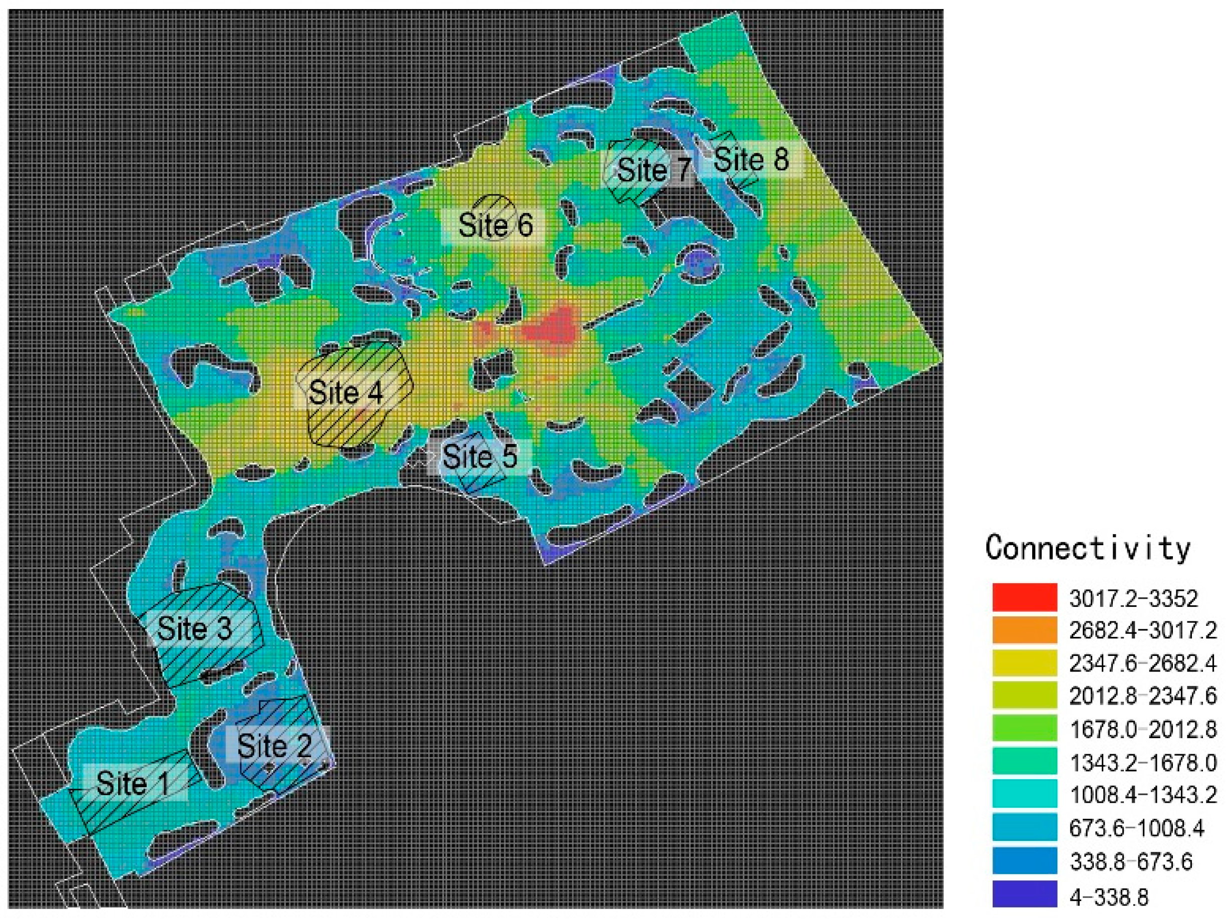
Openness is represented by the connectivity index, which refers to the number of grid cells directly connected with one space. From a cognitive perspective, connectivity represents the range of adjacent spaces that a person can see when standing in a space [
25]. A higher connectivity value denotes more open space with a larger visible range and visual permeability. The calculation of the connectivity
Ci for grid cell
i is as follows:
where
k represents the number of grid cells that can connect to grid cell
i by any straight line without obstacles in the middle. Please refer to the openness map generated in
Figure 5.
2.4. Generating Microclimate Map
Microclimate refers to the air temperature, humidity, thermal radiation, and wind speed on the site. These parameters are influenced by the layout and properties of vegetation, buildings, and pavement at the site, and thus are spatially heterogenous. These microclimatic parameters greatly influence human thermal comfort through heat transfer between the human body and the surroundings [
26,
27,
28,
29]. Microclimate is an important physical property of a space, since people tend to perform activities in spaces with a thermally comfortable microclimate. Please refer to the microclimate map generated in
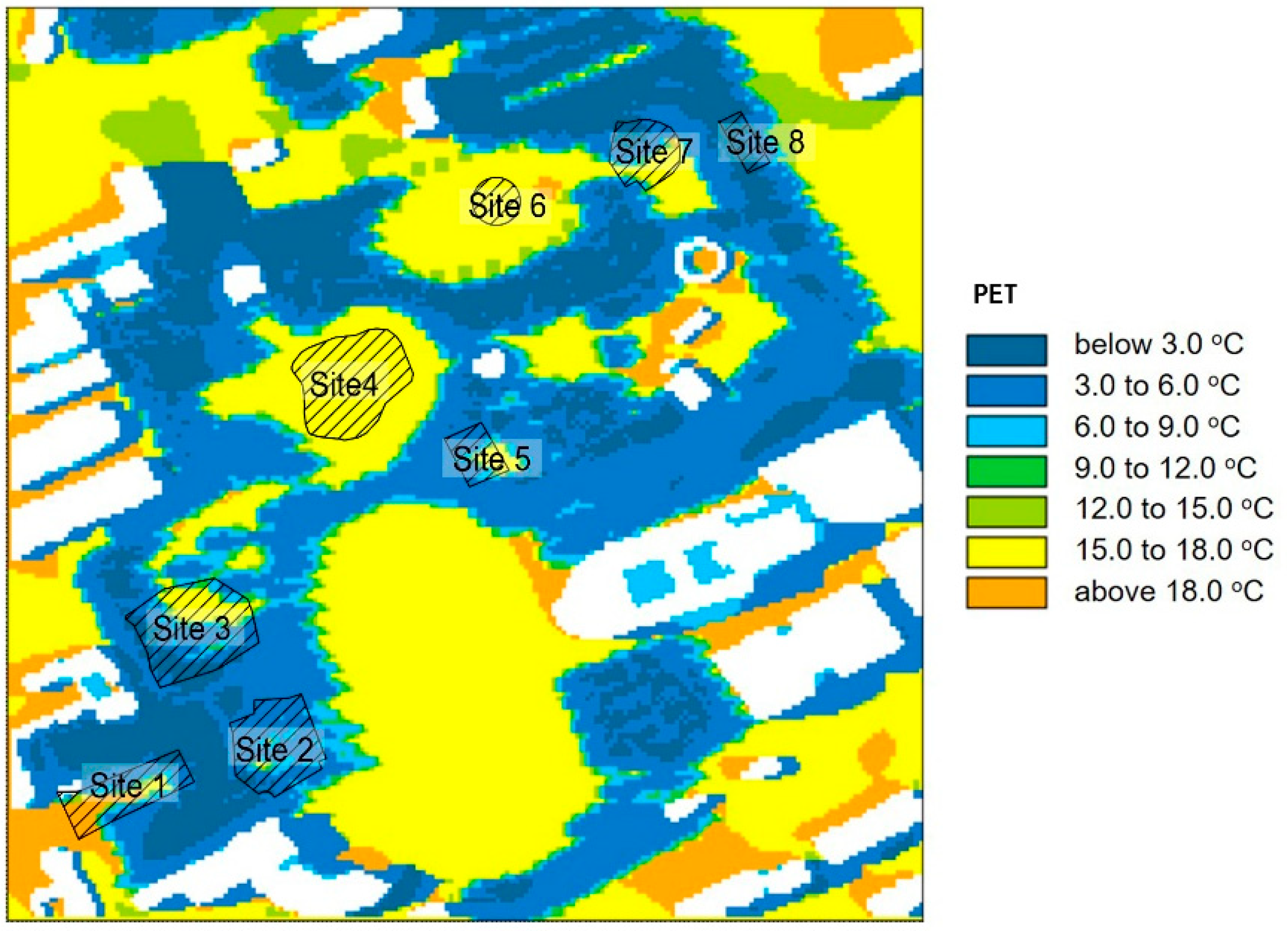
Figure 6.
We used the urban three-dimensional microclimate modeling tool ENVI-Met (version 4.4.5) to study the microclimate of Minhang Park. ENVI-Met estimates the influence of climate, building, vegetation, pavement, etc., on microclimate by numerically solving a set of flow and heat transfer equations. The validity of ENVI-Met has been demonstrated by several researchers [
30,
31,
32,
33] and, thus, is not the focus of the current study. The microclimate distribution obtained by ENVI-Met was further integrated into the space quality calculation.
Figure 7 shows the geometry of Minhang Park in ENVI-Met. To simplify the integration of outdoor space quality map, we used the same grid size for ENVI-Met and Depthmap at the pedestrian level, that is, 194 grid cells sized 2 m × 2 m for both x and y directions. Since ENVI-met is a 3D model, 25 grid cells with 2 m height were adopted in the z direction. Because the microclimate is modeled as three dimensional, the shape of grids in the z-direction is based on the actual building and vegetation configurations.
Since microclimate changes with the seasons, it is necessary to choose an appropriate time for the evaluation. We selected 3:00 p.m. on a typical sunny winter day as the time of assessment. The generally uncomfortable winters in Shanghai highlight the need for better microclimate. In addition, 3:00 p.m. was selected because it is a peak time for activities in neighborhood parks, according to a previous study [
3]. The input meteorological conditions for the calculation at 3:00 p.m. was air temperature of 3.4 °C, relative humidity of 40%, and wind 2.5 m/s with 10 m height from the southeast. Since the simulation started at 1:00 a.m., and 14 h had passed, it is reasonable to assume that the initial condition does not interfere with the result at 3:00 p.m.
For this work, we adopted a commonly used index in outdoor thermal comfort and heat stress studies, physiologically equivalent temperature (PET) [
34], as a comprehensive index to include the influences of air temperature, humidity, thermal radiation, and wind. PET is an equivalent temperature that is defined as the ambient temperature of a reference environment that will cause the same physiological response for a standard person as the actual environment would. In our study of a winter day in Shanghai at 3:00 p.m., PET was low, so a higher PET value indicates better microclimate and thermal comfort.
2.5. Generating Integrated Outdoor Space Quality Map
In this study, we calculated the outdoor space quality as the weighted average of normalized factors:
where
Q is the integrated space quality and
Qi and
wi are the normalized value (between 0 and 1) and weight of the
ith factor, respectively. The weights were determined according to the field surveys described in
Section 2.6. As expected, the weights should sum to one:
The three factors of accessibility, openness, and microclimate were considered in this study. As a result, the integrated outdoor space quality was calculated as:
Normalization of the accessibility, openness, and microclimate was carried out as follows:
where the subscripts
max and
min denote the maximum and minimum values within the site. Since greater MSD represents worse accessibility and microclimate conditions, we subtracted the normalizations by one. After a series of computations, the integrated outdoor space quality value
Q (between 0 and 1) was obtained for each grid cell on the pedestrian level for the entire site, with higher
Q values representing better outdoor space quality. The outdoor space quality map was then generated by visualizing the
Q value distribution on every grid cell.
2.6. Determining Weights Based on Field Surveys
Field surveys were conducted in Minhang Park on 26 December 2021, and 15 January 2022, to study the influence of accessibility, openness, and microclimate on occupancy. The number of occupants and microclimate parameters (air temperature, relative humidity, wind speed, and globe temperature) for the eight selected sites were obtained every 1.5 h at 8:00, 9:30, 11:00, 12:30, 14:00, 15:30, and 17:00. The number of occupants was directly counted; the air temperature, relative humidity, and globe temperature were recorded by a portable heat stress monitor (AZ8778); and wind speed was obtained by a hotwire anemometer (Testo 425).
In order to obtain the weights for each factor, we calculated and compared the standardized linear regression coefficients on the basis of regular coefficients obtained from linear regression. The linear regression can be expressed as follows:
where
Y is the dependent variable,
Xi is the independent variable (
i from 1 to
n),
βi is the coefficient corresponding to
Xi,
β0 is the constant coefficient, and
e is the random error term. The standardized regression coefficient
βi′ was obtained from the general regression coefficient
βi:
where
βi′ standardizes the
βi according to the ratio of the standard deviation of predictor
Xi (
SXi) over the standard deviation of the dependent variable
SY. The standardized coefficient
βi′ gives a rough indication of the relative importance of variable
Xi. A variable with larger
βi′ has a greater effect on the dependent variable. Standardized coefficients can then be used to calculate the contribution weights
wi by:
The weight wi for variable Xi is calculated by comparing the absolute values of the standardized coefficient of that variable βi′ over the sum of the absolute values of all standardized coefficients.
3. Results
Here, we describe the weight determination according to the filed survey data. The dataset includes the recorded occupant density, measured microclimate parameters, and calculated MSD and connectivity for the eight sites. Then, we present the generated maps of accessibility, openness, microclimate, and integrated outdoor space quality. Based on the maps, we propose a series of design strategies to improve the space quality.
3.1. Field Survey Results and Weight Determination
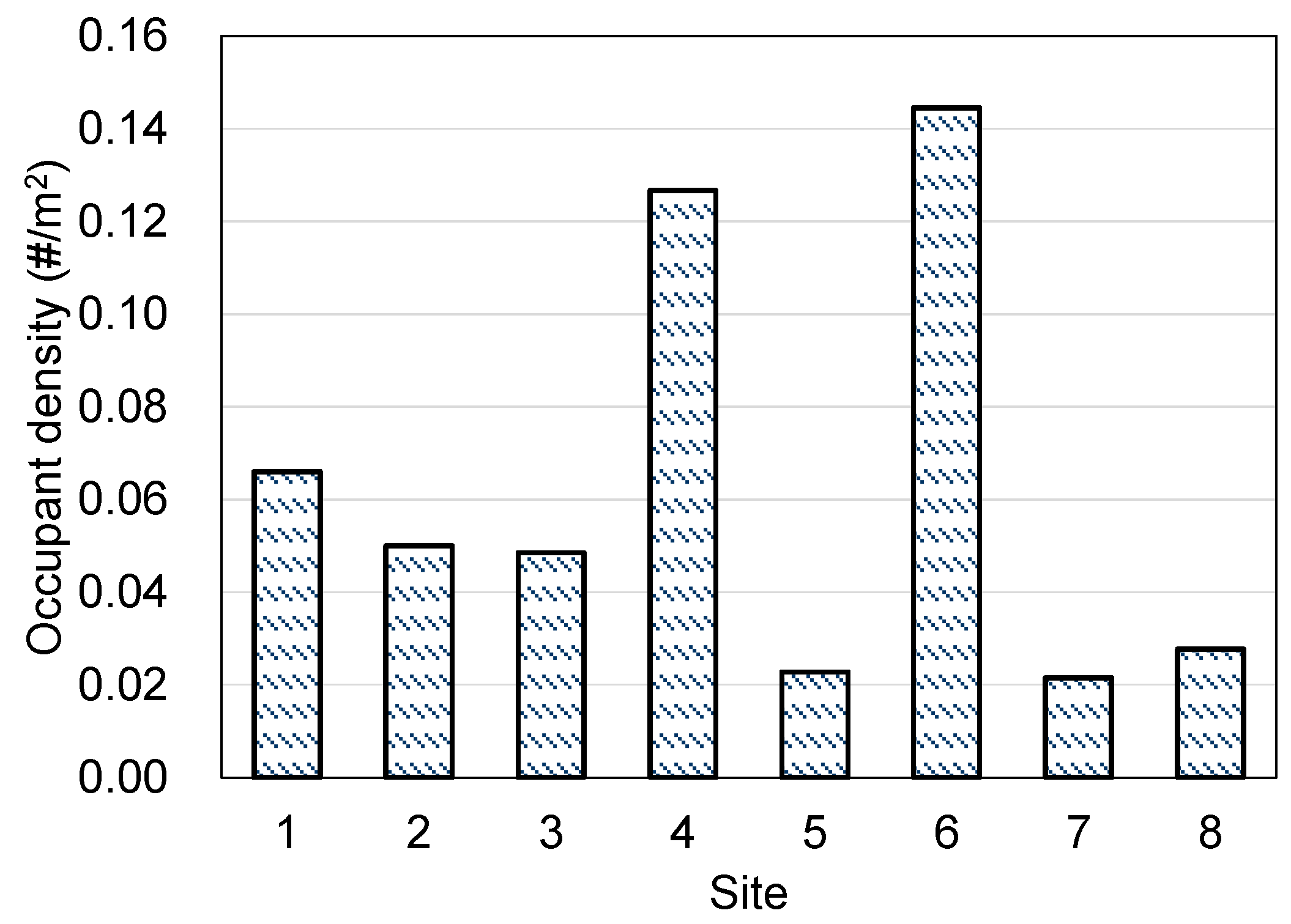
Occupant density is an indication of space vitality, since spaces with higher quality should attract more people. When calculating the occupant density at each site, the number of occupants obtained at various times during the two field surveys was summed to reduce uncertainty caused by daily life patterns.
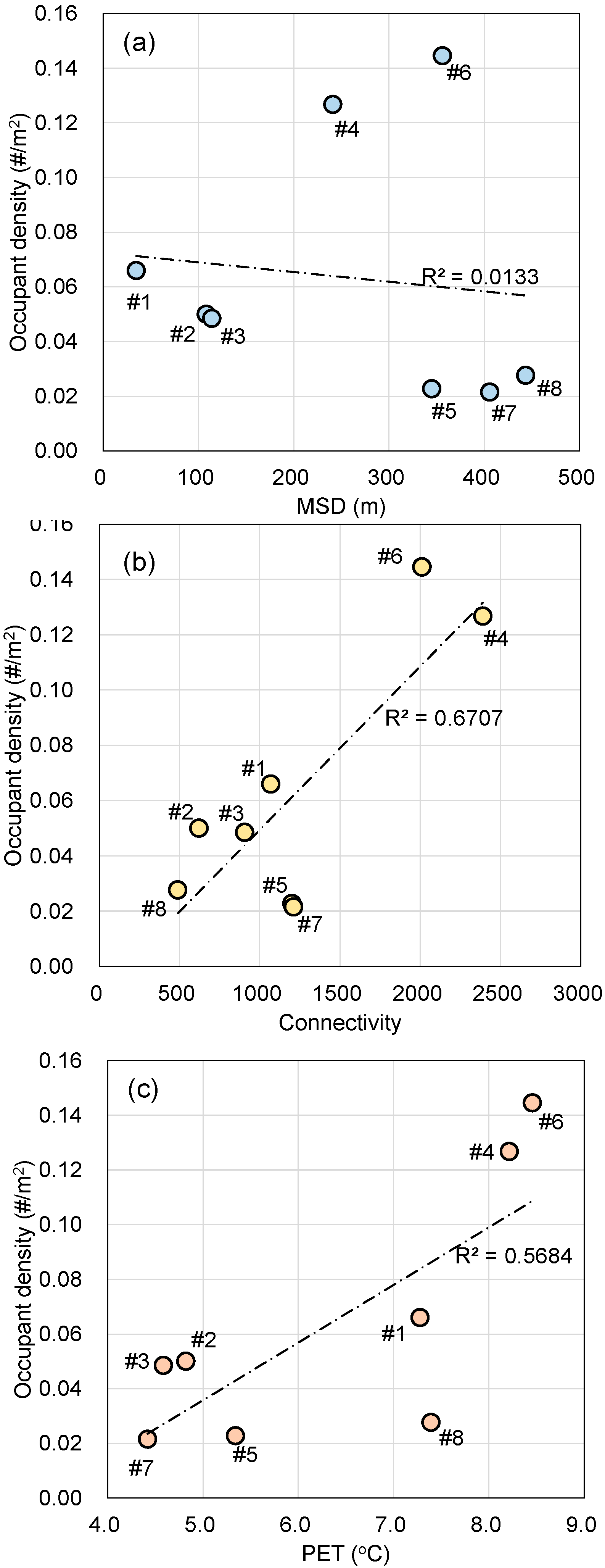
Figure 8 shows occupant density at various selected sites. Site 6 (a Western-style garden) and Site 4 (a large lawn) were denser than other sites. For Sites 1, 2, 3, 5, 7, and 8, occupant density decreased with increasing distance of the location from the entrance.
Figure 9 further shows the MSD, connectivity, and PET and their correlations with occupant density at each site. MSD and connectivity were obtained by using space syntax. PET was directly measured from the field surveys. At first glance, MSD correlated poorly with occupant density, but a closer look found that the occupant density of sites 4 and 6 generally decreased with the increase in MSD. Site 4 and Site 6 showed large deviations from the overall trend. The reason for the deviation is that these two sites have favorable connectivity and microclimate, as shown in
Figure 9b,c. The R
2 for the correlations of connectivity and PET with occupant density were 0.67 and 0.57, respectively, showing that sites with greater connectivity and PET had higher occupant density.
To obtain the relative weight of accessibility, openness, and microclimate on outdoor space quality, we conducted linear regression on the surveyed data. The occupant density was used as the dependent variable, and it was regressed by MSD, connectivity, and PET. The variance inflation factor (VIF) was used to examine the level of multicollinearity in the three-variable model. The VIFs were all less than 1.6, indicating an acceptable level of multicollinearity.
Table 2 summarizes the results of the linear regression. The adjusted R
2 for the regression was 0.75, which indicates that the three variables explained the variability of the occupant density reasonably well. The coefficients for the three variables were standardized, and corresponding weights were calculated. Based on these weights, the order of importance for influencing outdoor space quality (occupant density) is as follows: openness, microclimate, and accessibility. The relative weights of openness, microclimate, and accessibility were 45.5%, 34.8%, and 19.7%, respectively.
After the weights have been determined, the integrated outdoor space quality is calculated as:
3.2. Mapping Accessibility
Figure 4 demonstrates the accessibility of Minhang Park with metric distance (MSD) as the index. There is only one entrance in the southwest corner of the park, so the metric distance gradually increases from the entrance, and the accessibility becomes worse. Among the eight studied sites, the accessibility shows a general decreasing trend from Site 1 to Site 8. Site 1 is closest to the park entrance, and the average value of its MSD (i.e., the average distance from the park entrance to the site) is 34.8 m, whereas Site 8 is the farthest from the park entrance, with an average MSD value of 443.4 m. Traffic accessibility of space is an important feature of the quality of space. Space with better accessibility is easier for people to reach, thus attracting more occupants. Generally, being closer to the entrance of the park corresponds to better traffic accessibility and a greater number of occupants. In addition, traffic accessibility is more important for the elderly and people with poor mobility. For example, in Minhang Park, we observed a blind woman who went to Site 2 every day to practice Tai Chi, and she did not go any deeper into the park.
3.3. Mapping Openness
Figure 5 shows the spatial distribution of openness, as denoted by connectivity. Site 4 with a large lawn in the middle of the park has less shelter and wide visibility, so it has high openness. The average connectivity of activity Sites 6 and 7 is also high. Site 6 is a Western-style garden mainly composed of regular grassland and low shrubs, with adequate visual permeability. The central part of the park is at the intersections of several main traffic roads and few shelters are present; this space has the highest openness with a favorable view. However, it is only treated as a traffic space, so we did not select it as a target of study. The rest of the activity spaces are located at the corner of the park or surrounded by vegetation. With low openness, they were not easily noticed by visitors.
3.4. Mapping Microclimate
Figure 6 demonstrates the simulated PET distribution of Minhang Park at 3:00 p.m. on a typical winter day. Mainly dominated by shading, PET distribution shows two distinctive sets of values. The PET reached 15 °C under the sun in Sites 4 and 6 and was between 3 and 8 °C under shade for Sites 1, 2, 3, and 8. Using the PET thermal sensation category developed by Liu et al. [
35] for the hot summer and cold winter zone in China, the thermal sensation in sunny spaces was between “neutral” and “slightly cool”, while without sun, the thermal sensation was “cool”. The much lower PET and thermal sensation under the shaded sites compared to the sunny places signify the importance of accessing solar radiation on outdoor thermal comfort improvement in winter.
3.5. Mapping Integrated Outdoor Space Quality
Figure 10 demonstrates the integrated quality of outdoor spaces in Minhang Park. As can be seen, the quality of the space near the entrance of Minhang Park and in the middle of the park was high, while the quality of the spaces in the northeast of the park was generally low.
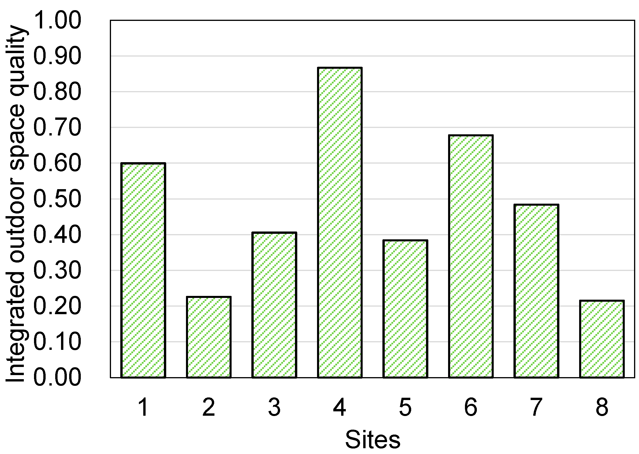
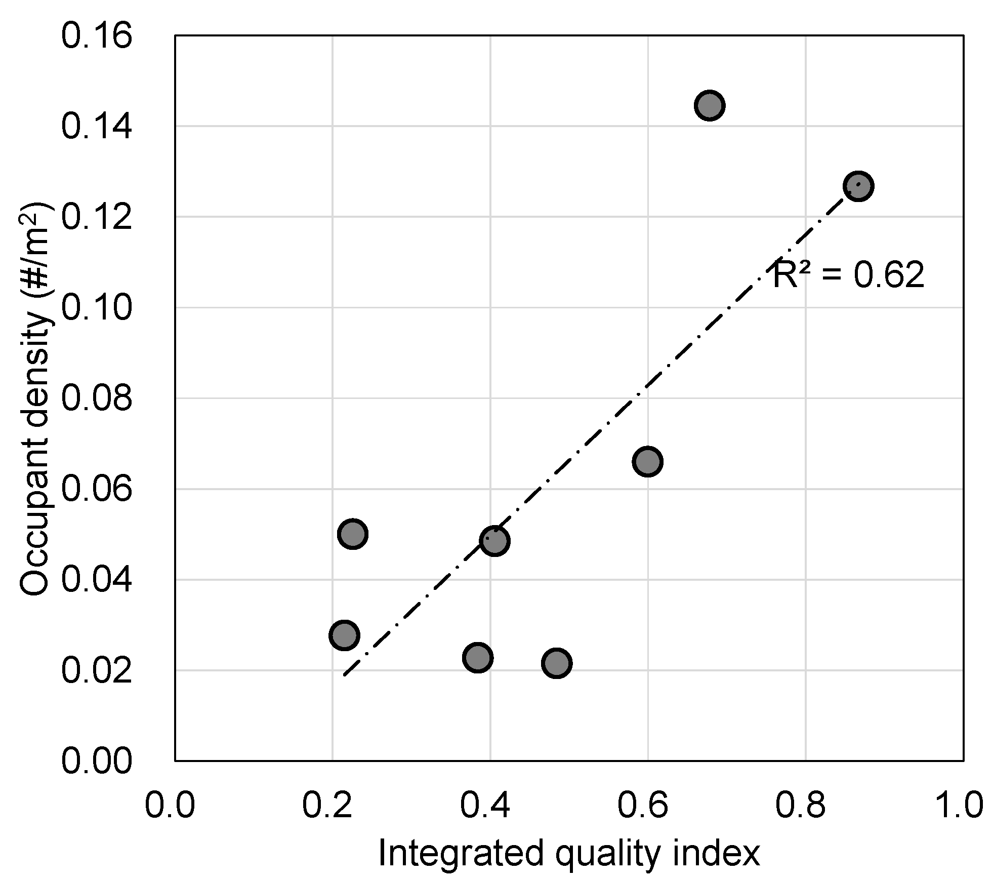
Figure 11 shows the value of the comprehensive quality index of the eight sites in Minhang Park. The comprehensive quality values of the eight sites are sorted from high to low as follows: Site 4 > Site 6 > Site 1 > Site 7 > Site 3 > Site 5 > Site 8 > Site 2. According to our initial observation of actual use of Minhang Park, Site 4 and Site 6 with high space quality also have many users. A positive correlation between the outdoor space quality and the space vitality (the number of active participants) in the park can be observed, as shown in
Figure 12.
4. Discussion
4.1. Design Strategies According to the Space Quality Maps
Through the mapping of outdoor space quality of the park, the characteristics of each space can be better understood. Mapping can provide a basis for proposing rational design strategies, including location selection, function definition, and resources allocation. According to the assumptions of this study, when designing outdoor spaces, all the factors including accessibility, openness, and microclimate should be considered. Designers can allocate various functions to spaces with different quality, and particular design strategies can be applied to improve the quality. Based on the mapping, our proposed design strategies to improve the quality of Minhang Park include the following:
- (1)
Sites can have different functions based on the result of quality mapping. For example, a space with suitable traffic accessibility is recommended as the activity site for the elderly and people with mobility difficulties. A space with weak traffic accessibility and low spatial openness can be used as a private activity space.
- (2)
Spaces with low space quality can be improved through targeted design strategies according to the weak aspects of quality evaluation. For example, in a space with poor microclimate conditions, the microclimate can be improved by adding shading facilities and vegetation in summer, and providing wind protection and solar exposure in winter. For a space with insufficient openness, the openness of the space can be improved through the adjustment of vegetation and shelters to meet the needs of different users.
- (3)
Some spaces have high quality, but are not effectively utilized. They can be transformed into active places through design. Some spaces are only treated as traffic spaces without any rest or activity facilities, and people rarely stay there. Such places should be effectively used by attributing function and adding facilities.
4.2. Limitations
For this study, we only selected a typical winter afternoon for the evaluation of the microclimate because microclimate modeling programs such as ENVI-met are usually computationally intensive. However, large climate differences exist in different seasons in Shanghai. The microclimate map would be completely different if summer was the target of analysis. If a method could be developed to accelerate the microclimate calculation, then annual analysis should be considered.
When analyzing the accessibility, we assumed that “closer is better”. However, there might be a threshold value for accessibility. Some studies recommended setting up resting points for the elderly every 100 m [
36]. In other words, accessibility is acceptable within a certain distance.
We did not include facilities as an outdoor space quality factor, because the facilities do not belong to the space itself. However, facilities are important to promote activities. For example, Minhang Park has a place with fitness equipment, and that place attracted many users, but we did not include it in the analysis.
4.3. Future Studies
In this work, we generated an outdoor space quality map for Minhang Park. An underlying assumption of this study is that sites with higher quality attract more occupants. This assumption corresponds with our field survey data. However, there are other factors, such as aesthetics, safety, facility, and pavement property etc., influencing people’s choice of places. For example, the reason for Sites 4 and 6 having a much higher quality than others may be due to the additional facilities in the two spaces. More empirical research should be conducted to investigate the comprehensive effect of other factors, and to test the assumption of the relationship between integrated space quality and vitality.
For the current study, we defined the outdoor space quality index as a weighted sum of normalized factors. A more reasonable definition may be proposed. For example, the effect of microclimate may be “multiplicative” rather than “additive”, since the microclimate may affect attendance in general. More research on the relationships between the factors and attendance is needed to reasonably define the outdoor space quality index.
5. Conclusions
The usage level of urban open space was largely determined by the outdoor space quality, which constitutes many factors. Increasing open space quality can promote urban vitality and sustainability. Here, we proposed a method to generate an integrated outdoor space quality map that includes the influences from accessibility, openness, and microclimate. The space syntax tool Depthmap was used to generate the accessibility and openness maps, and the microclimate modeling tool ENVI-Met was employed to estimate the spatial distributions of microclimate (denoted by PET index). The accessibility, openness, and microclimate on each grid cell were normalized, weighted, summed, and visualized to obtain the integrated outdoor space quality map. The weights of different factors were calculated via data obtained from field surveys of a neighborhood park in Shanghai, China. It is found that openness had the highest weight, followed by microclimate. Accessibility had the lowest weight among the three selected indicators.
The proposed method was used on a neighborhood park in Shanghai to generate an outdoor space quality map by integrating the accessibility, openness, and microclimate. Analyses were conducted on eight sub-sites on a typical winter day to compare the individual quality factors and integrated quality. Places with high openness often had better microclimate conditions in winter due to higher solar exposure, so their integrated quality were also high. Based on the space quality maps, we proposed design and renovation strategies to improve the space quality, such as utilizing traffic space with high quality and improving the microclimate conditions for spaces with favorable accessibility and openness.


