1. Introduction
Coastal groundwater systems represent both crucial water resources for growing population centers and complex hydrologic systems sensitive to changes in both land-use practices and climate. A number of authors have studied various aspects of coastal hydrogeology. Recent case studies have, for example, focused on a number of coastal systems including zones in Australia [
1], Belgium [
2], Denmark [
3], Italy [
4], South Africa [
5], South Korea [
6], Spain [
7], and the United States [
8,
9,
10]. Others have focused on the impact of changing land-use on the salt-water/freshwater interface [
11], the complexity of vegetation in coastal environments [
12], the impact of the 2004 tsunami [
13], and integrated management of coastal environments [
14]. A major focus of coastal studies has been the prediction, management and prevention of salt-water intrusion [
1,
15,
16].
Two significant conclusions derived from this literature revolve around the difficulty of predicting groundwater characteristics through mathematical models in coastal environments and the impact of hydraulic transients on the distribution of salt in the vicinity of the salt-water/freshwater contact. With respect to challenges in modeling, [
15] suggest that accurate prediction of salt-water intrusion is extremely difficult under the limitations of current modeling capabilities. Other authors [
17] extend these concerns to the difficulty of attempting inversion of models in the presence of density-dependent flow. One can conclude from arguments such as these that modeling must be combined with extensive monitoring and characterization to allow sustainable management of coastal aquifers.
The impact of hydraulic transients in coastal environments has also been studied by a number of authors ranging from early work by [
18] to recent work by such authors as [
19]. Conclusions from these studies suggest that mixing and penetration of both salt water and other contaminants will increase in the presence of tidal or other dynamic changes in groundwater hydraulics. Hence, study of the source and impact of transients in coastal groundwater systems is of interest.
The extensive literature on coastal environments has provided the technical foundation for ongoing studies of a coastal aquifer system in Benin, West Africa. This aquifer system, accessed via a series of wells known as the Godomey well field, represents the sole source of freshwater supplying the city of Cotonou, Benin. This well field is located approximately 5 kilometers north of the Atlantic Ocean, and borders a large lake on the eastern edge of the well field that contains saline water (at least during the dry period of the year). Critical management questions relative to the suitability of the Godomey well field include: (i) for what period of time can the aquifer be expected to provide water for this urban population, (ii) what sources of contamination represent the most severe threats to this groundwater resource, (iii) what hydrologic properties of the recharge zones and deep aquifer system need to be more thoroughly characterized to assist in modeling this groundwater system, and (iv) what hydrologic properties of the recharge zones are likely to be impacted by climate change, population migration, or changing land-use practices.
This paper provides an overview of recent efforts that begin to address these questions, as well as continuing efforts required to more fully characterize this critical aquifer system. As a result, this paper presents preliminary results that provide initial insight into the processes controlling sustainability of this water resource as well as the work required to more fully characterize and manage this complex groundwater resource. The work discussed represents a combination of results from two projects: collaboration between the Universite d’Abomey-Calavi (UAC, Benin) and Danish Water Engineering (DWE, Denmark) and collaboration between UAC and the University of Notre Dame (UND, USA). A number of students from both Benin and the United States have been involved in this effort [
20].
2. Coastal Benin and the Godomey Well Field
The geology of coastal Benin, the region of interest, has been previously described ([
21,
22,
23,
24,
25,
26], and a number of unpublished reports from the Benin government water agency). Summarized in
Figure 1, this zone consists of interbedded sand, silts, and clays forming a series of interconnected aquifers and confining layers. The shallow geology near the coast reflects a series of approximately parallel ancient beach environments separated by lowlands (now wetlands), all at elevation close to sea level. This shallow geology transitions with distance from the coast through increase in elevation and evolution into deeper sediments with better defined surface-soil layers.
Several of the deeper geologic units extend below the Bight of Benin (Atlantic Ocean) and are therefore potentially exposed to salt-water influx. In addition to the ocean, the system is bounded by Lake Nokoue, a large shallow lake (with a maximum depth during the rainy season of approximately 3 meters) which is connected to the ocean by a small, constructed canal and which varies in salinity from relatively low concentrations (less than 1,000 mg/L) during the rainy season to very high concentrations (greater than 10,000 mg/L) during the dry season [
27].
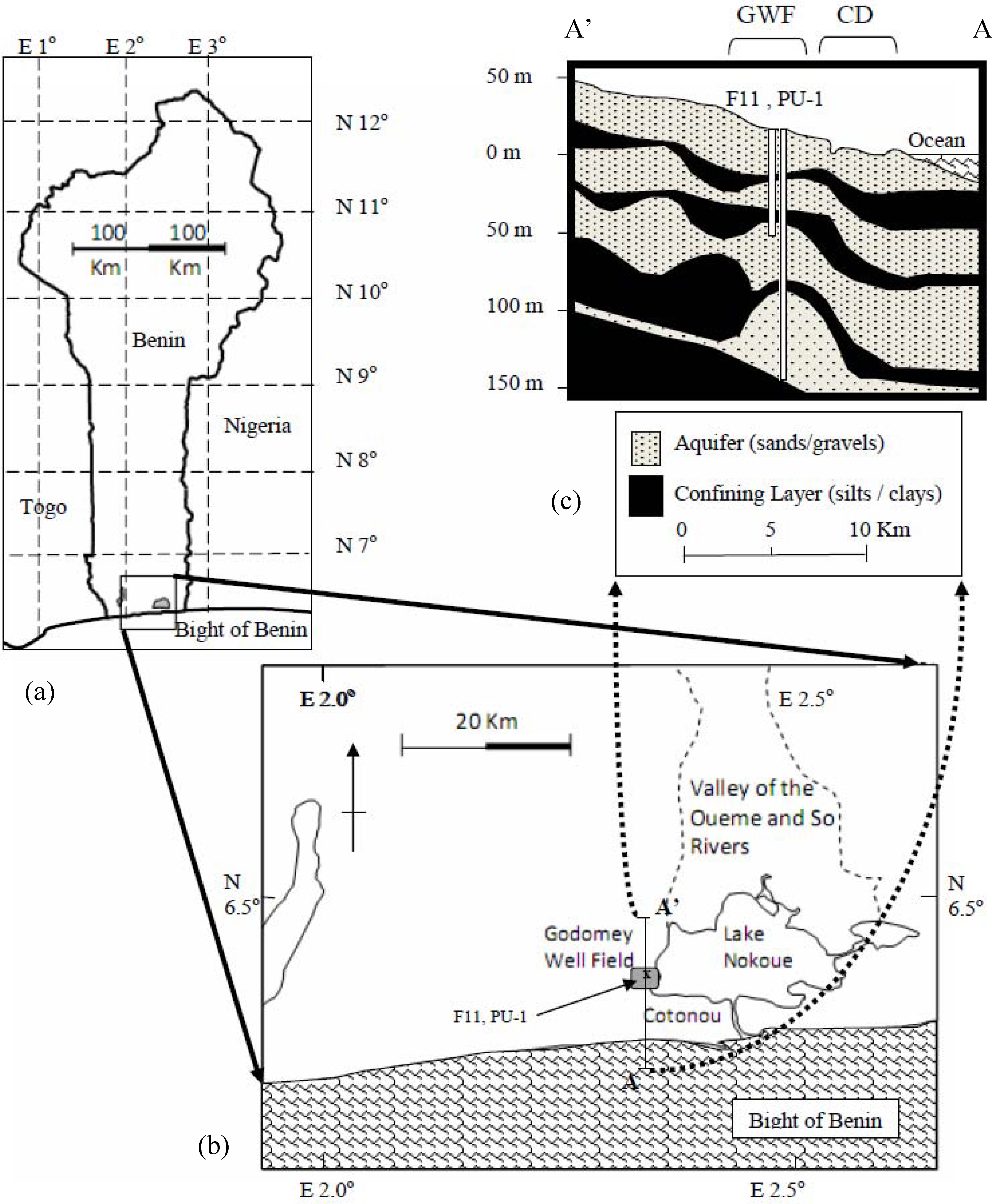
Figure 1.
Benin, West Africa (a), with an enlargement of the coastal region representing the focus of this study (b). All wells identified in this paper are within the region labeled as the “Godomey Well Field” on the coastal map and latitude/longitude is derived from satellite images derived from Google Earth (earth.google.com, accessed, 05/2010). A north-south cross section (c) is shown providing an approximation of the subsurface layering in this coastal region as well as the location of the Godomey Well Field (GWF), the location of well F11 and piezometer PU-1 (introduced below), and the coastal data zone (CD) where the resistivity and water quality data were collected (discussed below).
Land use in this region varies from major urban development (Cotonou) to small rural villages. Within Cotonou, substantial portions of the land-surface have been substantially manipulated leading to decreased local recharge and increased runoff. The result is a substantial degree of surface flooding during the rainy season along the southern portions of the urban region. Substantial portions of land outside of the urban area remain open wetlands; these open areas are interspersed with small villages where substantial infilling has occurred in support of creating land surface for construction of homes, salt production and agricultural activities. Many of these developed localities are subject to standing surface waters (fresh or saline) during the rainy seasons.
The portion of coastal Benin of interest for the present study underlies Cotonou, Benin, and the surrounding region. Cotonou is the largest population center in Benin (population estimated at 2 million). The water supply is based on groundwater withdrawal from the Godomey well field (
Figure 1, [
24,
28]), with more than 20 wells penetrating one or more of the confined and semi-confined aquifers (screen depths from 30 m to greater than 100 m below ground surface). Rate of pumping has been on the increase since approximately 1970; a rate of 1.7 × 10
6 m
3/yr in 1970 to more than 17 × 10
6 m
3/yr in 2006. The rate of increase over the period 1996–2006 has been nearly constant at 0.9 × 10
6 m
3/yr per year with new wells added to the system at increasing distances from Lake Nokoue.
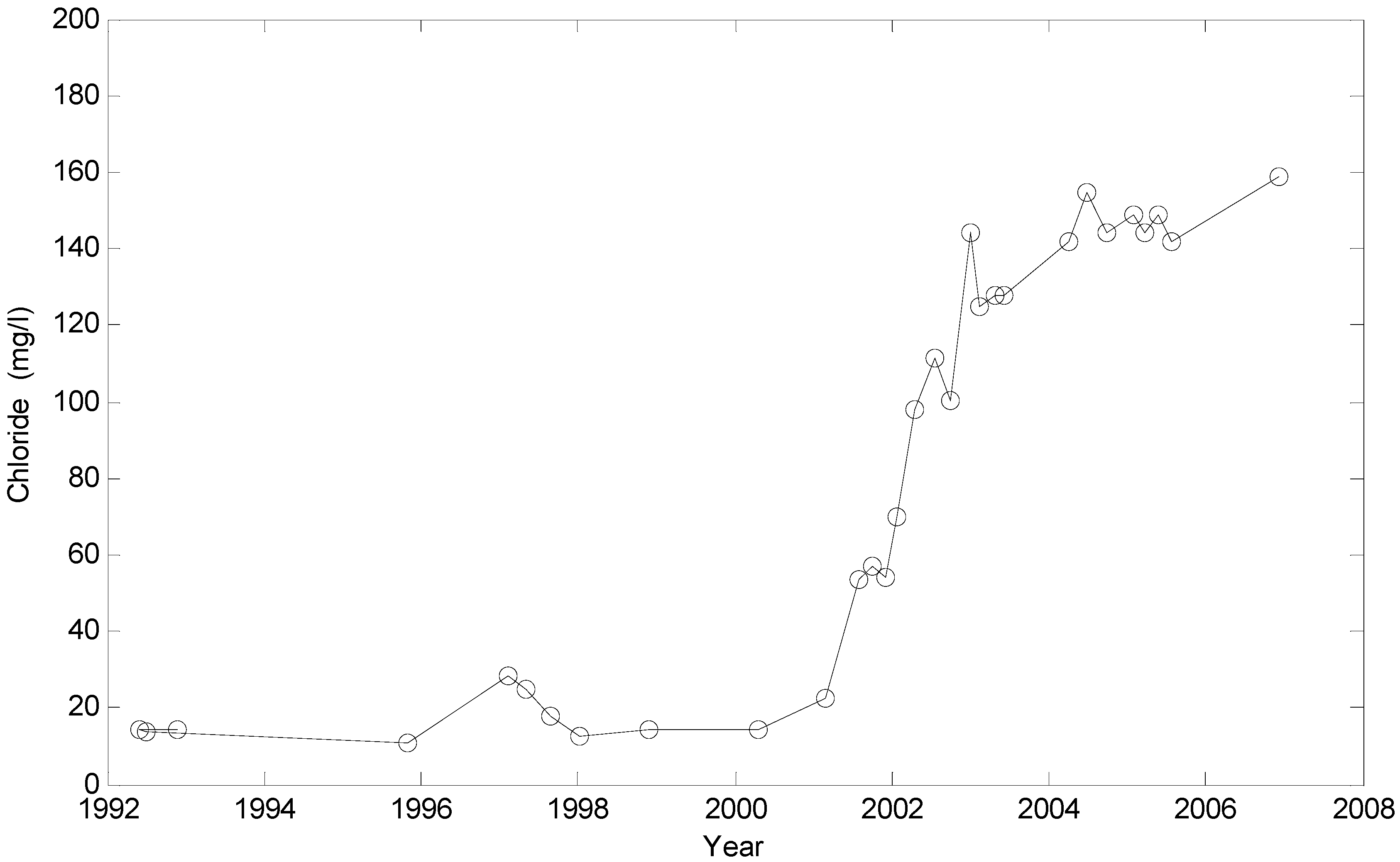
The increase in pumping from the Godomey well field has been accompanied by increased salinity in the wells. Initial indications of increased chloride were observed as early as 1991 in wells and piezometers close to Lake Nokoue on the eastern portion of the well field.
Figure 2, for example, shows the variation in chloride in well F11 (location shown in
Figure 1) as recorded by the water agency in Benin. Significantly, the wells showing increase in chloride are all close to the lake, indicating that the source of the salinity is likely from the lake rather than the ocean. There is currently no indication of increased salinity in the southern-most wells (those closest to the ocean), indicating that the ocean salt-water transition zone has not yet reached the well field. However, prior studies of salinity along the coastal zone show that initial migration of higher salinity waters may have already occurred inland of the coastline directly south of the well field [
25,
26].
These previous studies of the region bounding the Godomey well field raise questions of sustainability of this water source that are tied to questions of the quality of water recharging the well field, the complexity (heterogeneity) of the subsurface geology in the region of the southern coast and Lake Nokoue, and the water-quality characteristics of the lake during periods in which the lake is recharging the underlying aquifers. In the sections below, recent efforts in modeling and field characterization of these particular attributes are presented, along with preliminary results of these efforts. Observations derived from these individual efforts are then integrated to provide an overall picture of challenges and opportunities relative to the sustainability of the Godomey well field.
Figure 2.
Chloride variation in well F11, screened in the first confined aquifer, during the period 1992–2008 showing increase in chloride concentration in 2001–2004. For comparison, historical chloride concentrations in the three confined aquifers were generally less than 30 mg/L.
Figure 2.
Chloride variation in well F11, screened in the first confined aquifer, during the period 1992–2008 showing increase in chloride concentration in 2001–2004. For comparison, historical chloride concentrations in the three confined aquifers were generally less than 30 mg/L.
3. Numerical Modeling: Multiple Assessments
A number of sequential efforts have been focused on developing basic models of groundwater flow and transport in the aquifer system encompassing the Godomey well field. To date, these modeling efforts have provided insight into potential hydraulic and transport processes impacting the Godomey well field as well as guidance on where continuing efforts at field characterization may provide for improved prediction of future behavior of this aquifer system. Although useful in these regards, the models are not yet at a level whereby they provide reliable tools guiding specific management plans (other than in broad conclusions about global management strategies). Rather, combined with the ongoing field efforts, these modeling efforts help to identify where further study is necessary to achieve long-term, sustainable management of this water resource.
The Benin research team [
24] report on initial efforts to model flow (without transport) assuming steady-state conditions for both the monthly mean well production as measured during the period 1991–2000 and again for anticipated rate of production in the year 2011. The geologic cross section was simplified to four material types with material properties and spatial distribution of recharge estimated through calibration to historical data.
Results from this initial modeling study led to two significant predictions relative to flow towards the production wells. First, the model predicted that, even under increased production from the wells, a groundwater divide exists in the littoral (coastal) zone that separates the ocean from the well field. Hence, while the southern lagoon regions may contribute recharge to the well field, the model predicts the absence of salt-water intrusion directly from the ocean. Second, while the model based on the 1991–2000 mean rate of production predicted only low levels of recharge from the region bounding Lake Nokoue, the projected rate of production from the well field in 2011 led to prediction of substantial increase in recharge derived from the lake.
The UAC/UND partnership extended this flow model through refined discretization and detailed analysis of well logs leading to more complex distributions of hydraulic conductivity. This effort focused on a number of sensitivity studies including model sensitivity to boundary conditions, hydrologic conditions in the littoral zone, spatial distribution of recharge, and water level in Lake Nokoue. This effort was once again based on assumed steady flow conditions. Results from this unpublished work provided further support of the need to characterize recharge from the lake, particularly during periods of elevated water levels in the lake. Further, this sensitivity analysis demonstrated relatively high sensitivity to recharge and drainage conditions in the lagoon region along the coast, thus encouraging further field characterization efforts in these areas. Finally, this work indicated that as rate of production increases, the northwestern portion of the Cotonou urban region becomes active in terms of recharge contributing to the well field, thus suggesting increased potential for anthropogenic contaminants to impact future water quality (and therefore increased interest in characterizing groundwater fluxes in this region).
Finally, efforts by UAC/DWE (as described in detail in [
28]) substantially extended the original [
24] model through introduction of transients and density-dependent transport (using the U.S. Geological Survey computer modeling codes MODFLOW and SEAWAT for density effects: water.usgs.gov/nrp/gwsoftware/modflow.htm). This model has provided opportunities to study the hydraulic behavior of this aquifer system as well as provide initial insight into the potential for chemical transport from Lake Nokoue to the Godomey wells. Calibration of this model was based on hydraulic and chemical records from a number of wells and piezometers in the unconfined aquifer as well as within each of the confined aquifers. Further, this effort involved reanalysis of a number of historical pump tests in an effort to refine estimates of the permeabilities and storage parameters of the hydrologic formations. The model was calibrated against historical hydraulic and chemical data from a series of wells and piezometers. (Additional details of this modeling effort are beyond the scope of this manuscript and are contained in [
28]).
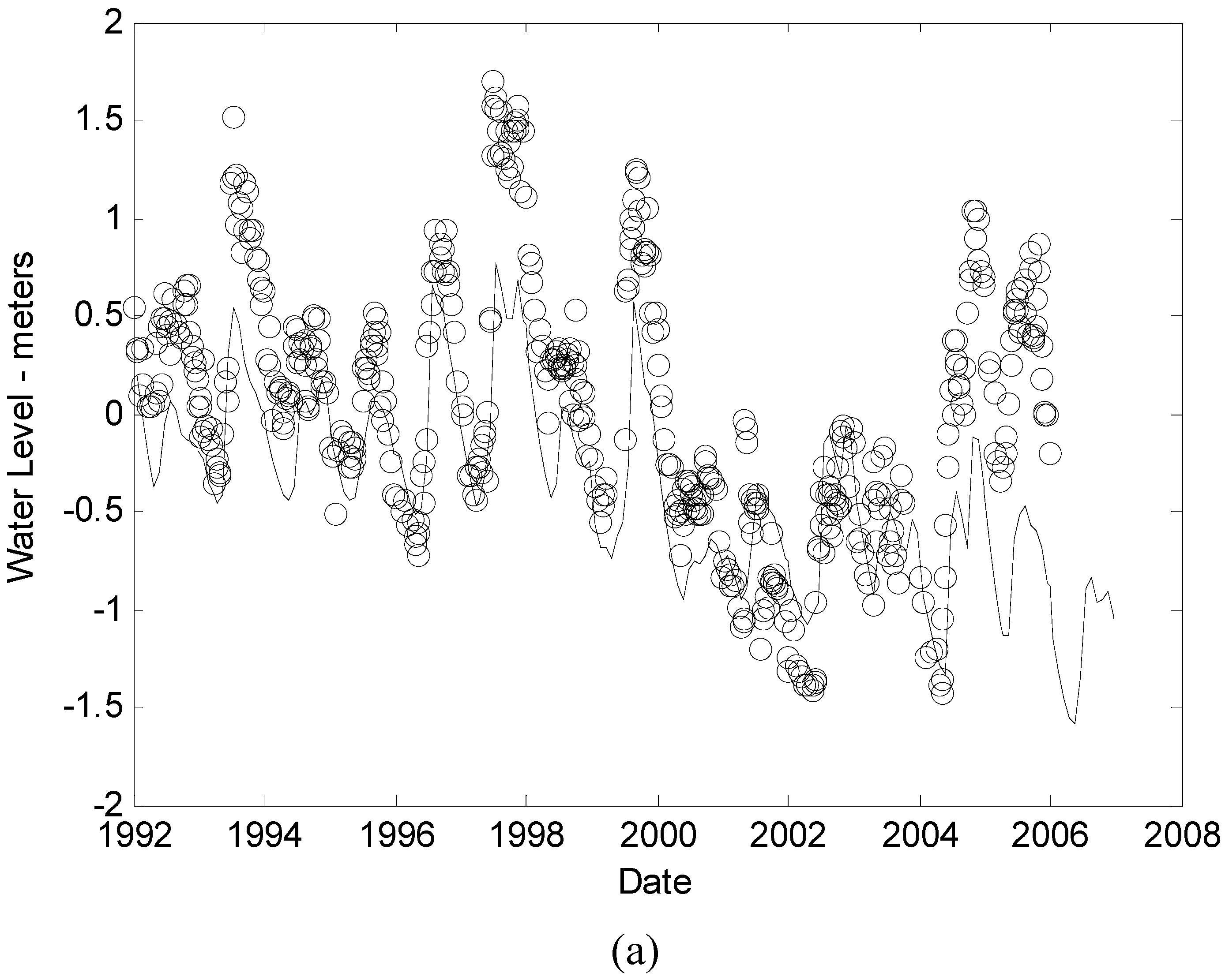
While the model has been able to reproduce the details of variation in hydraulic behavior at specific wells and piezometers (e.g.,
Figure 3a shows the comparison of observed and predicted variation in the screen at 65 meters within the piezometer nest, PU1), challenges remain in the modeling effort in terms of temporal/spatial distribution of hydraulic head (e.g.,
Figure 3b shows the predicted and observed differences in hydraulic head in the screens at 65 meters and 135 meters in the same piezometer, PU1). This model has also provided initial insight into the spatial distribution of chloride as derived from Lake Nokoue (e.g.,
Figure 3c for well F11), providing strong support of the argument that the lake is currently a significant source of salinity to the groundwater system, and that its contribution to the salinity of groundwater is likely to increase with increased production from the Godomey well field. These results provide initial confidence that, with improved field characterization, a transient density-dependent model can be developed for this region that is sufficient to assist in long-term management of the groundwater resource. At the same time, the results demonstrate that additional field characterization is required, particularly in the realm of hydraulic properties of the aquifers, recharge (quantity and quality from Lake Nokoue) and hydraulic/chemical behavior of the coastal wetlands.
The immediate benefit of these modeling studies is two-fold. The models provide initial insight into management strategies which might be followed over the coming 5–10 years to minimize the impact of salt-water intrusion on the overall water supply serving Cotonou. For example, both the UAC/UND and UAC/DWE studies indicate that terminating production from the initial wells showing the presence of increased salinity was likely not an optimal management strategy as terminating production from these wells is predicted to result in increased rate of migration of the salt-water front towards the remaining wells. Further, the UAC/DWE study has provided for recommendations as to locations for the placement and depth of new wells to help support the water demand of Cotonou and surrounding areas.
These studies have also provided insight into regions in southern Benin where greater hydrogeologic characterization may provide substantial improvement in the modeling capability. Specific characterization potential is suggested by all three modeling efforts in terms of the hydraulics of Lake Nokoue, quantification of the permeabilities of the primary aquifers, and hydraulic/chemical processes in the littoral zone. Field characterization efforts were based on insights derived from these modeling activities.
Figure 3.
Select modeling results: (a) Observed (circles)
versus predicted (line) water level in piezometer PU-1 (location shown in
Figure 1) for screen depth of 65 meters, (b) Observed (circles)
versus predicted (line) difference in water levels in piezometer nest PU-1 between the screen at 65 meters (below mean sea level) and the screen at 135 meters (below mean sea level), (c) Observed (circles)
versus predicted (line) salinity profiles for well F11. All data taken from [
28].
4. Hydraulic Characterization of Aquifers
As discussed in [
28], several historical pump tests are available for analysis of aquifer characteristics. While these tests have been assessed and incorporated into the most recent, density-dependent modeling effort, there are significant limitations related to the performance/analysis of these tests. Hence, new pump tests are being pursued to further characterize the aquifer parameters so as to improve the quality and reliability of the modeling efforts. For these tests, shut-in wells and/or piezometers are being used as observation wells to monitor response to changes in discharge from one or more of the Godomey well field production wells. Water levels, in this case, are being monitored at 5 second intervals using pressure transducers and data loggers.
While the performance and subsequent analysis of these tests continues, the tests performed to date have demonstrated several features, as well as challenges, of significance to the ongoing studies.
Figure 4 shows two water level records (both recorded in shut-in wells) covering periods of multiple days and located at locations where primary impact on water level should come from a single production well. The first plot is response in a planned pump test: the water level was monitored for a period of approximately 12 hours before the initiation of a period of approximately 2 hours of pumping followed by shut-in of the well. While this two-hour pump response (and recovery) can be fit quite well to the Theis solution, the limited period of pumping allowed by the water company minimized the opportunity to observe later time deviations from a Theis type response due to leakage, heterogeneity, or interference from other production wells. Pump tests such as these have the potential to provide reasonable local estimates of hydraulic parameters, but only limited ability to look for later-time behaviors.
The second plot in
Figure 4 illustrates the ability to record longer-term hydraulic response, but also a significant observation about production rates in this system. In this case, a pressure transducer was placed within a shut-in well with the goal that a local production well would be shut off for a period of three hours sometime during the period of record, thus providing a negative pump test (known reduction in pumping). Following the period of record, it was determined that—due to unforeseen circumstances—the water company had not had the opportunity to intentionally turn off production. It was therefore anticipated that there would be little signal recorded at the observation well (all wells in the region were thought to be running at constant rate of production throughout the period of the test). As shown in
Figure 4b, however, there were multiple transients in this record. Further exploration of the reasons for these transients led to the conclusion that periodic, but unplanned, loss or reduction in the energy grid resulted in unplanned variation in rate of discharge at the nearest production well. While the government water agency accounts for this variability through recording cumulative volume of pumpage, such variability is of concern from the standpoint of pressure/flow transients in the aquifers. Specifically, as noted by other authors [
18,
19], oscillatory flow can lead to mixing at salt-water/freshwater fronts, thereby increasing the rate of intrusion of salinity into the freshwater aquifers. While these results imply that additional study is warranted with respect to the influence of these unplanned/unmonitored transients, they also show the potential utility of recording water level transients at observation points even during periods for which no planned hydraulic testing is anticipated.
Figure 4.
Two well response records in response to changes in production in wells at the Godomey well field. (a) Response to planned pumping at a new production well, and (b) Responses to multiple, unplanned changes in production at a well (in this case, the primary response is to the cessation of pumping). Note that the vertical axis in these two figures is reversed (depth to water (a) and water level (b)).
5. Characterization of Shallow Groundwater in Coastal Benin
As identified through the modeling efforts, the coastal region of Benin is of substantial interest because of potential migration of salinity from the coastal region as well as the distribution of recharge, and thereby flow pathways, in the coastal region. Further, shallow groundwater along the coast is of importance to a number of small villages distributed throughout the coastal region. Hence, a number of field efforts have been directed towards better understanding of current water quality conditions along the coast.
In terms of water quality studies, two sets of field methods have been applied to characterizing water-quality in the shallow subsurface. First, a manual, direct-push method has been applied along coastal Benin (over 40 sites) to provide vertical profiles of water quality (surface, ~1 m, ~3 m, ~5 m, and ~7 m at select locations). Based on review of the literature regarding use of chemical signatures to characterize mixing of different groundwater sources [
29,
30,
31,
32,
33], these samples were analyzed for a number of chemical species, including Chloride, Sodium, Bromide, Nitrate, Phosphate, and Sulfate as well as Electrical Conductivity [
34]. Results from analysis of these data demonstrate three distinct aspects of the behavior of the shallow coastal aquifer system.
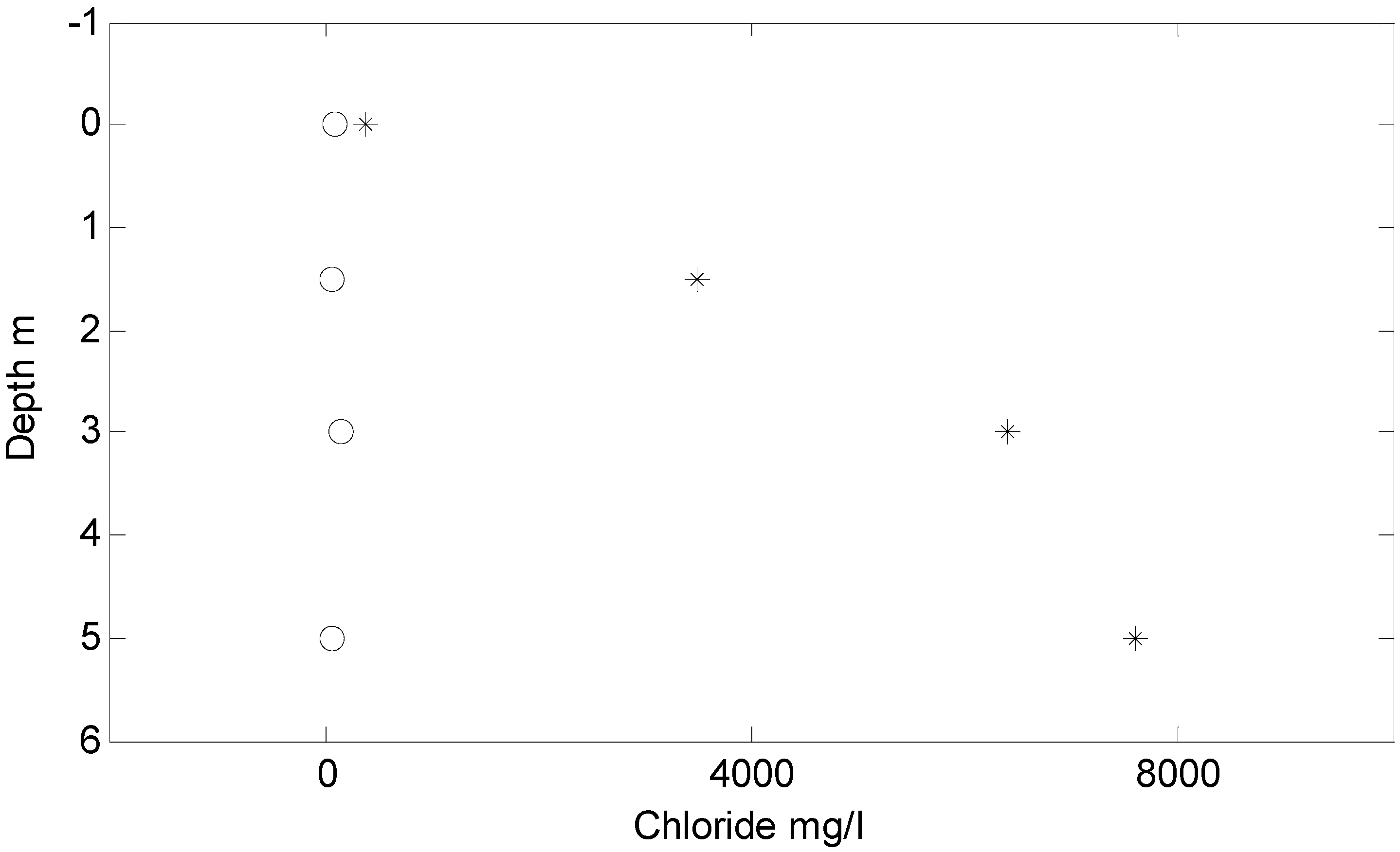
First, the data provide evidence of substantial spatial variability in the chemistry of the shallow groundwater.
Figure 5 shows chloride concentration
versus depth for two sample locations in very close proximity (less than 20 meter separation) and located within the same wetland area (although in different locations relative to the movement of surface water in the wetland). The difference in concentration is nearly an order of magnitude at all depths, suggesting substantial spatial variation in subsurface chemistry and groundwater fluxes.
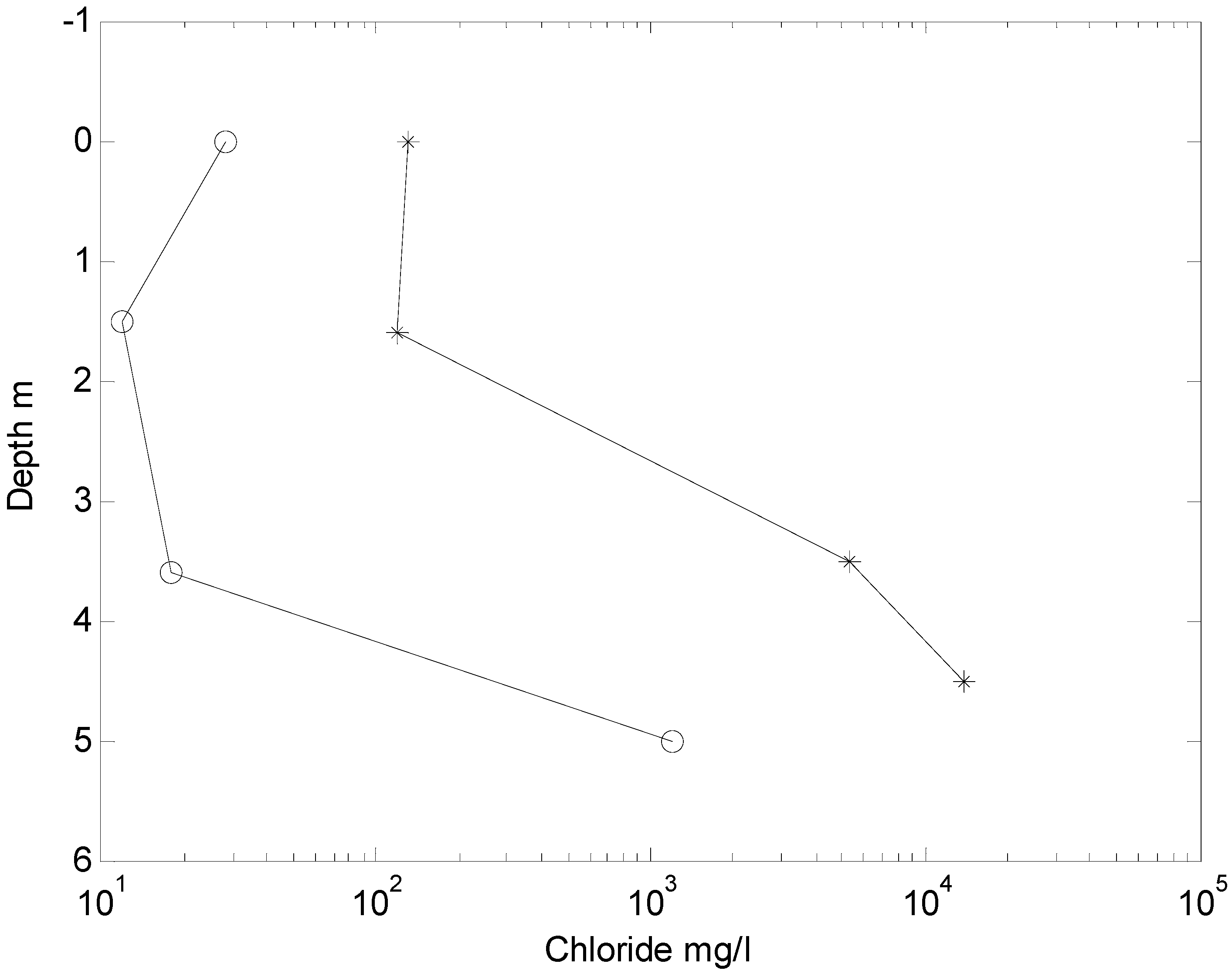
Second, as represented both in
Figure 5 and more clearly in
Figure 6, distinctly different chloride profiles in the lagoon region (in the case of
Figure 6, a horizontal distance of 1.5 km between samples) suggests differences in the hydraulic/chemical behavior at these locations, including the possibility of substantial spatial variation in recharge behavior. Strong recharge at one location (the circles in
Figure 6) is represented by low chloride concentrations at the surface and all sample depths whereas neutral or upflow at the other location (represented by the asterisks in
Figure 6) is indicated by low concentration in the surface water, but elevated concentrations in the subsurface.
Finally, as shown in
Figure 7, the chemical data (particularly those points for which the chloride concentration was above 4,000 mg/L) indicate high chloride concentration at 5 m depth along the coast, on the southern shore of Lake Nokoue, and inland in the area immediately south of the Godomey well field. Analysis of the distribution of chemical signatures near the Djonou River south of the well field is the focus of continuing field sampling in an effort to determine the northern-most extent of the saline water intrusion. These data are being combined with the modeling efforts in order to better understand the degree to which the intrusion of saline water inland is a result of natural
versus anthropogenic influences.
Figure 5.
Chloride concentration versus depth at two sample locations located within the same open body of water separated by approximately 20 meters.
Figure 5.
Chloride concentration versus depth at two sample locations located within the same open body of water separated by approximately 20 meters.
Figure 6.
Chloride versus depth for two sample locations (‘o’ representing four samples versus depth at the first site, ‘*’ representing four samples versus depth at a second site). Although in similar locations relative to the coast, these two locations show substantially different behavior in terms of the chloride distribution with depth implying substantial variation in terms of recharge/discharge characteristics within the coastal region.
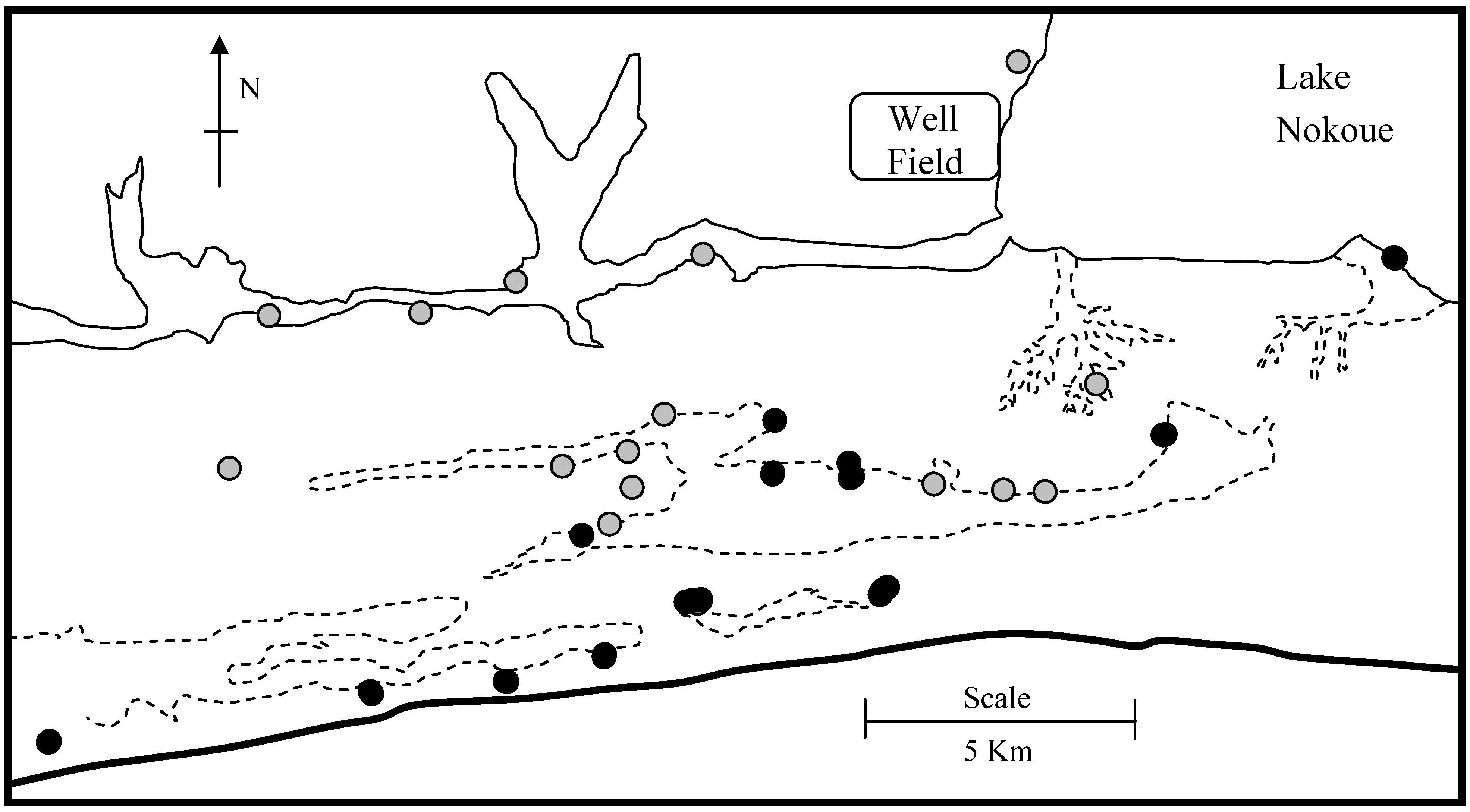
Figure 7.
Location map of shallow aquifer samples. Gray samples had chloride concentration <400 mg/L at 5 m depth. Black samples had chloride concentration >400 mg/L at 5 m depth.
Figure 7.
Location map of shallow aquifer samples. Gray samples had chloride concentration <400 mg/L at 5 m depth. Black samples had chloride concentration >400 mg/L at 5 m depth.
Variations in water quality and sediment type were also assessed through application of electrical resistivity imaging at a number of sites. A 24-electrode Wenner array was used to measure apparent resistivity values for a series of electrode separation distances. Through the use of an inverse modeling strategy [
35], the apparent resistivity data were used to produce a two-dimensional image of the subsurface resistivity distribution.
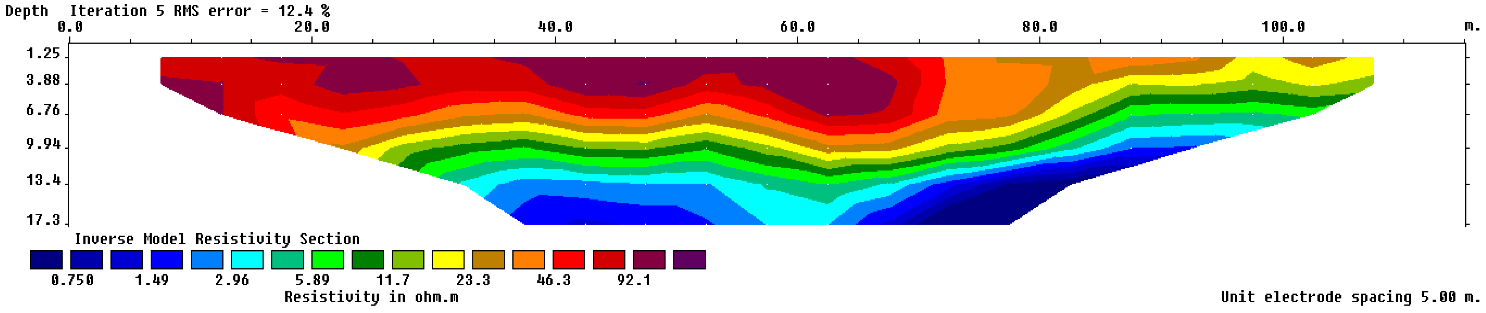
Figure 8 shows one of these subsurface profiles in which there is a distinct transition from high resistivity near the surface towards low resistivity at depth. Comparing these resistivities to those of common aquifer materials, these profiles are interpreted as indicators of spatial variations in water quality and/or sediment type. The transition to very low resistivity in
Figure 8, for example, suggests the presence of high salinity (low resistivity) water below approximately 9 meters.
Apparent resistivity values may also be interpreted through assessment using theoretical curves that assume horizontal layering of the subsurface sediments (homogeneous within each layer) [
36,
37].
Figure 9, for example, shows the fit between a two-layer model curve and observed resistivity as a function of electrode spacing at one of the coastal sites. In cases where the resistivity of the lower layer is consistent with that of saline groundwater (≤3.0 ohm-m), these fits provide an approximate depth to salt-water in the subsurface. Out of 26 sites where resistivity measurements were collected, 10 provided clear indication of a low resistivity layer with locations and depths as shown in
Figure 10. An additional 10 profiles indicated an absence of salt water (absence of low resistivity) through the depth of the interpretation (approximately 18 meters). These results show a spatial image of depth to salt-water that is relatively consistent with additional indications of salt-water intrusion in the region south and southeast of the Godomey well field, but also reflects a relatively complex system with local variation in the depth to the freshwater/saline interface.
Figure 8.
Dimensional distribution of estimated subsurface resistivities derived from a resistivity line centered at 6.37
oN, 2.33
oE. This example is chosen as an example of transition from high resistivity near the surface to low resistivity at depth. The location of this point relative to the coast is shown in
Figure 10 and the orientation was 100
o East of North.
Figure 9.
Fit between theoretical curve and apparent resistivities observed in the field. The fitting procedure allows estimation of the depth to the change in resistivity as well as the resistivities of the upper and lower layers. Resistivities in the range of 3.0 Ohm-meter or less are interpreted as indicating salt water in the sediments.
Figure 10.
Locations where electrical resistivity profiles provided clear delineation of either low resistivity layer (squares) or no evidence of salinity through 18 meters depth (gray circles). The values shown next to the squares are the estimated depth to the transition to salt water. The square that is circled is the location of the resistivity line with results shown in
Figure 8.
Beyond the water quality sampling, near surface (<1m depth) hydraulic conductivities have been measured at approximately 50 locations (the same locations as for the water quality sampling) using a modified falling-head permeameter. These data show an approximately 3 order of magnitude variation in the instrument response with a drop in magnitude generally tied to the depth and density of organic matter present at the surface. These data once again suggest substantial spatial variation in recharge/discharge.
6. The Potential Role of Lake Nokoue
Lake Nokoue plays a potentially important role in the quantity and quality of local recharge to the Godomey well field. Unfortunately, only limited prior studies are available regarding variation in water level or water quality in Lake Nokoue over the various time scales impacting this water body {ranging from tidal, to annual precipitation [
27], to longer-term variation related to climate}. Further, there are no previous efforts of which we are aware that provide evidence of groundwater exchange through the sediments underlying Lake Nokoue.
In an effort to gain understanding of the exchange of water between Lake Nokoue and the groundwater system, seven clusters of multi-level pizometers (
Figure 11) have been installed in the lake sediments at depths of 1 m, 2 m, and 3 m. These piezometers are distributed in the western third of the lake and from the inflow of the So River (to the north) to the southern coast. While these piezometers have been in place only since the summer of 2009, initial data indicate a dynamic lake in terms of both hydraulic gradient and water quality in the sediments. For example, the upper image in
Figure 12 shows the variation in water levels in the lake and at 2 meter depth in 6 of the 7 piezometer nests (piezometer nest 3 failed to produce water samples or reliable water levels for several of the sampling periods). Variation in the lake level demonstrates that the So River is more responsive than the lake in general and that the southwestern region of the lake apparently shows slightly different hydraulic behavior than the remainder of the lake.
Figure 11.
Distribution of nested piezometers in Lake Nokoue.
Figure 11.
Distribution of nested piezometers in Lake Nokoue.
Variation in the piezometer levels (
Figure 12b) once again shows greater response in the So River than the more southern sites. In addition, the piezometers appear to show greater magnitude response than the surface water (perhaps related to a peak in the lake elevation between sampling points) as well as a delay in the response relative to the lake level (again, suggesting that the peak level in the lake may have occurred between measurements at 40 and 80 days). Finally, there appears to be a gradient in subsurface response from north to south (piezometers 1 and 2 showing the largest responses and piezometers 6 and 7 showing the smallest responses).
Although quite preliminary, the water quality data show substantial spatial variation within the lake. For example,
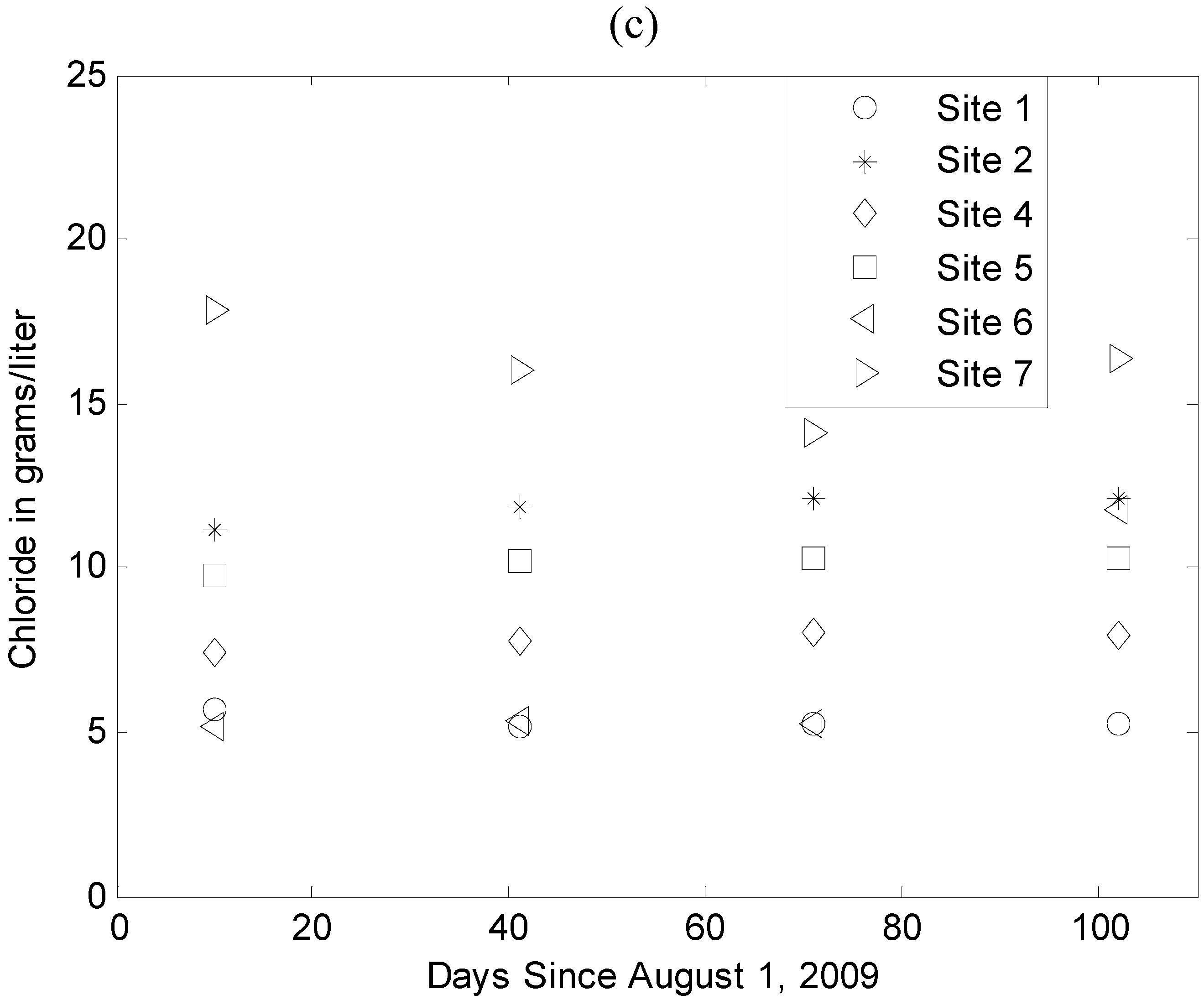
Figure 12c shows the variation in chloride concentration across the piezometers as a function of time. Unlike the tendency in the water levels, the distribution of the chloride concentration does not show (at this time) consistent variation in space. However, the concentrations during this period of the year are consistently above 6000 mg/L, suggesting that groundwater recharge derived from the lake during this period of the year will show elevated elemental concentrations.
Figure 12.
Variation in water level (positive means increase in water level) at six of the seven sampling locations on Lake Nokoue during the summer/fall 2009: (a) lake elevation and (b) water level in the piezometers at 2 m depth.
Figure 12c shows variation in chloride concentration (grams per liter) during summer/fall 2009 for the deepest piezometers at each site over the same sampling locations. Neither water level nor chloride concentration are reported for site 3 due to technical difficulties.
7. Integration of Efforts
As noted in the opening of this manuscript, the efforts reported on herein represent relatively early efforts in understanding and modeling this complex hydrogeologic system. While the results reported herein are therefore preliminary and, in many aspects, incomplete, the modeling and field efforts described above provide an integrated (albeit initial) picture of current conditions and potential future threats to this water resource.
First, the various modeling efforts presented are consistent in a number of observations. Of particular interest from a sustainability standpoint, these models are in agreement with the argument that the majority of the recharge supporting the Godomey well field under current conditions is derived from the region north of the well field. Given relatively light historical development in this region, it is anticipated that this portion of the recharge will remain a reliable inflow to the aquifer in terms of both quantity and quality. Certainly, changing land use in this region must be monitored to ensure that this source of water is not threatened by additional or competing well fields or contamination through adverse land uses. This domain has, however, been identified on multiple occasions [
28] as the direction in which the well field must expand to meet increasing future demand.
Second, the modeling efforts generally agree that, while Lake Nokoue may have been a minor source of groundwater recharge as recently as 10 years ago, increase in production of water from the Godomey well field either already has resulted in, or will result in, increased recharge from the western portion of the lake. This has multiple implications for future management and data requirements. Lake Nokoue varies in both water level and quality (e.g., [
27] plus the initial data derived from the nested piezometers). Significantly, the lake is expected to be at its lowest salt concentration at the same time that it is at its highest water level. Hence, one can anticipate a beneficial correlation between water quality and rate of recharge: substantial research needs to be focused on the lake, starting with the piezometers discussed herein, the fundamental data sets required to define this boundary of the groundwater model. Increased recharge will likely lead (as indicated by initial sensitivity studies) to a broader spatial impact of Lake Nokoue on the well field: the result of this impact is the potential loss of additional wells to influx of saline, or otherwise contaminated, waters. The fact that all piezometers in the lake are showing at least 5,000 mg/L chloride in the upper 2–3 meters reinforces the need to reconsider the role of the lake in net recharge to the groundwater system as the earliest of the models led to the conclusion that the lake was a net discharge surface-water body, a conclusion that is inconsistent at least with the initial data.
Third, the models were generally consistent in predicting that saline waters from the Bight of Benin were not yet a threat to the well field. However, these models are based on assumptions about the hydraulic and chemical characteristics of the shallow aquifer system along the coast. Studies of this aquifer system are warranted from three viewpoints: (i) the models are sensitive to the assumed boundary conditions along the lagoon region of southern Benin, hence errors in these assumptions may lead to substantially different conclusions regarding the threat of contaminant transport from this region, (ii) the field efforts (water quality and resistivity) provide indications, consistent with earlier studies, that there is a higher permeability region immediately south of the Djonou River and Godomey well field—these data suggest a degree of encroachment of saline waters at relatively shallow depths in this region—hence, further study of this critical region is warranted from the standpoint of documenting existing encroachment in an important recharge area, and (iii) the shallow aquifer represents a significant source of water for the small villages distributed in the lagoon region—hence, any increase in encroachment of saline water or reduction in fresh-water recharge related to land-use activities may jeopardize the water resources for these rural populations.
The coastal region is also of substantial interest from the standpoint of potential climate change. The field data demonstrate a very complex system with rapid variation from freshwater to saltwater in both the surface and subsurface environments. Further, the land-surface elevation is close to sea level throughout the lagoon region. Hence, changes in mean sea level, total precipitation, timing of precipitation, or evapotranspiration may have potentially major impacts on the freshwater/saltwater and wetland/dryland balances along the coastal region (including the southern portion of the urban center of Cotonou).
Fourth, the combination of the modeling and data analysis support the prior assumption that this is a complex hydrogeologic system which presents a number of challenges in terms of characterizing hydraulic response to pumping and the associated movement of salinity towards the production wells. As noted in the previous paragraphs, existing and new threats are apparent. Further, both the modeling and the water quality analyses performed to date indicate that an increasing portion of the recharge for the well field is being derived from the northwestern urban area comprising Cotonou and Calavi. Generally, land use in this area represents significant potential for groundwater contamination. Finally, the complexity of the subsurface hydraulics creates a difficult modeling environment when the spatial distribution of such parameters as permeability, effective porosity, and specific storage are poorly characterized. As a result, it is difficult at this time to provide confident advice on management strategies. For example, the closure of a group of production wells near the lake was a management decision focused on preventing the introduction of contaminated water into the public water supply. However, in the long term, ending production at these wells may result in more rapid migration of salinity and other contaminants to wells further from the lake. Better management decisions, in this case, may involve use of the older production wells to create hydraulic barriers protecting the remainder of the production wells. Suggesting adoption of such management strategies, however, requires confidence in both the hydrology of the well field and any impacts associated with disposal of the discharged water. These types of strategies need to be considered, but can only be evaluated to the point of application through substantially greater characterization, and more refined modeling, of the hydrology surrounding the current and future wells included in the public water supply.
8. Summary
Two research groups, each including collaboration with the Universite d’Abomey-Calavi, have focused substantial recent efforts on characterizing and modeling the behavior of the groundwater aquifer system providing freshwater to Cotonou, Benin, and surrounding areas. The sole source of potable water, sustainability of this aquifer system is critical to the continued economic development of this, the largest, city in Benin. Efforts that are being applied include multiple approaches to numerical modeling, hydraulic testing to improve parameter estimates, monitoring on Lake Nokoue to determine current conditions and likely changes in those conditions over time, and monitoring of hydraulics and salt-water encroachment in the coastal lagoon region. Results to date indicate that this is a very complex coastal, hydrogeologic system with potential contaminants being derived from Lake Nokoue, the ocean, and anthropogenic contaminants associated with the Cotonou/Calavi urban area. At present, neither the modeling nor the field characterization efforts have risen to the level that predictions can confidently be made relative to the impact of continuing population expansion (with the associated increase in rate of production from the well field) and/or changing climate. Of particular interest are increased knowledge of aquifer hydraulic parameters, hydrologic/chemical conditions in the coastal region, and the contribution (quantity and quality) of Lake Nokoue to subsurface recharge.
This field characterization and modeling efforts continue with the goal of providing science-based management strategies to both maximize the potential utility of this water resource for a growing population and minimize the probability of severe contamination events (from salt-water intrusion or anthropogenic contaminants) compromising portions of this water resource. Further, this work should help inform political and management decisions that will, by necessity, require consideration of factors well beyond the technical issues discussed herein.


