Initial Study on Triaxiality of Human Settlements—In the Case of 10 Districts (Counties) of Dalian

Abstract
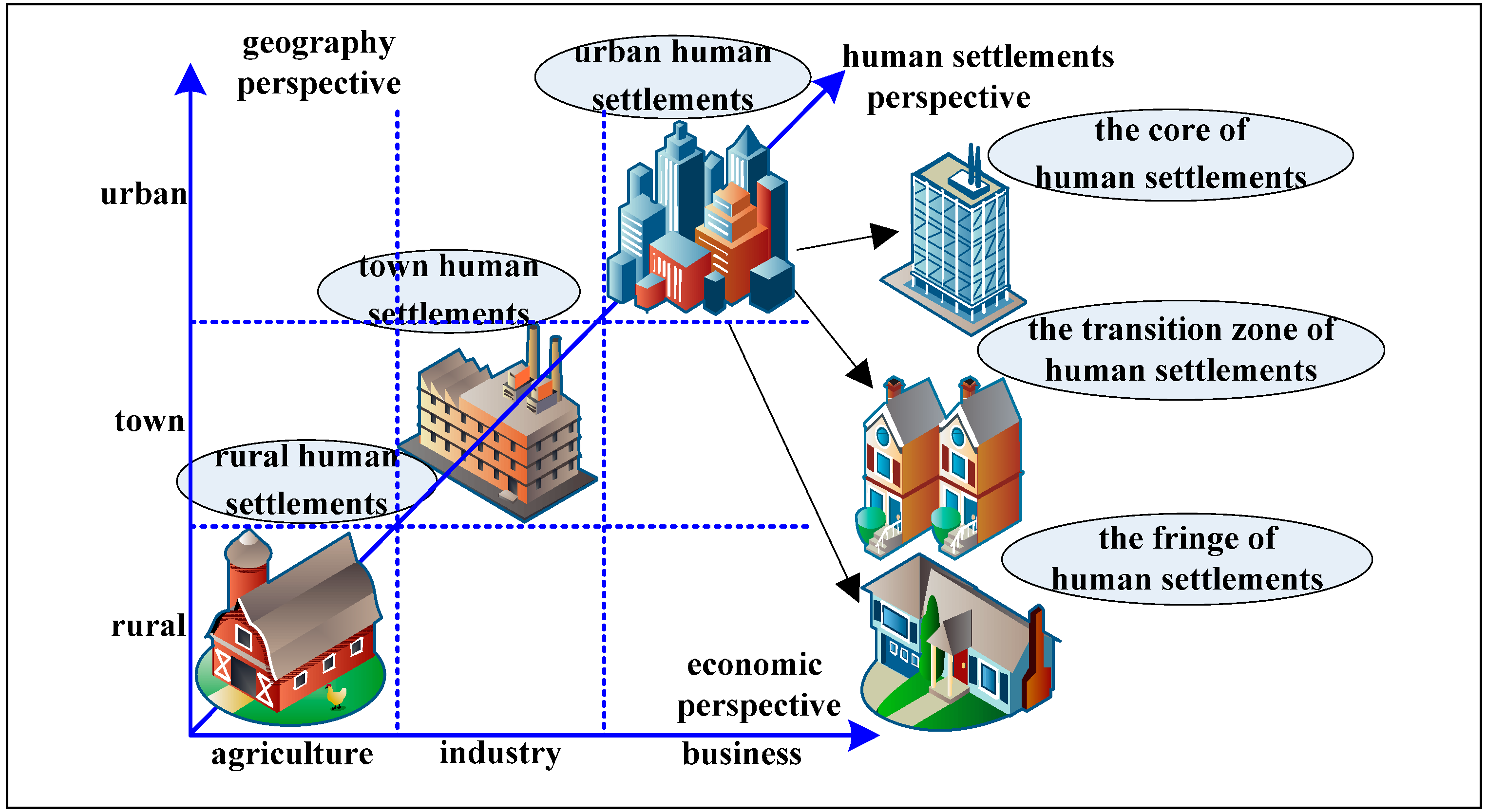
:1. Introduction

2. Date and Methods
 ; reverse indexes,
  in the case of zero, whereby we could not continue operation; and (2) Natural logarithm, in the case that the index value in the matrix is negative, whereby we could neither calculate the specific weight directly nor take the logarithm. There are two main methods to improve the entropy value method: the efficiency coefficient method and the standardized transformation method. For the use of the efficiency coefficient method, it is required to add subjective ingredients, which cannot reflect objective results; the evaluation results of the standardized transformation method are not only objective but also unique. In this paper, we adopted the standardized transformation method for use in data processing. The specific procedures are as follows:
- (1)
- Original matrix: X = {xij}m×n (0 ≤ i ≤m,0 ≤ j ≤n), xij represents the index value of No. j index of No. i city (district and county).
- (2)
- Standardized processing of data:
![Sustainability 06 07276 i003]() , where xj represents the average value of No. j index value, and σj represents the standard deviation of No. j index value.
, where xj represents the average value of No. j index value, and σj represents the standard deviation of No. j index value. - (3)
- Elimination of negative value:
![Sustainability 06 07276 i004]() , K represents the scope of translation of axes.
, K represents the scope of translation of axes. - (4)
- Calculation of the weight of No. i city (prefecture and county) of No. j index:
![Sustainability 06 07276 i005]() .
. - (5)
- Entropy value of index:
![Sustainability 06 07276 i006]() , k = 1/ln m, ej ∊[0,1].
, k = 1/ln m, ej ∊[0,1]. - (6)
- Differential coefficient: gj = 1 − ej.
- (7)
- Calculation of weight of No. j index.
![Sustainability 06 07276 i007]()
- (8)
- Calculation of degrees of livability of human settlements (Degrees of Livability):
![Sustainability 06 07276 i008]() .
.


| Comprehensive Index Layer | Single Index Layer |
|---|---|
| Natural system | mean temperature (°C); precipitation (mm); sunshine hours (t); average wind speed (m/s); average barometric pressure (HPa); windy days (day); extreme maximum temperature (°C); extreme minimum temperature (°C) ; frost-free season (day) |
| Population system | sex ratio (%); natural population growth rate (‰); aging rate (%); divorce rate (‰);The proportion of primary industry practitioners (%);The proportion of secondary and tertiary industry practitioners (%) |
| Social system | The registered urban unemployment rate (%);The proportion of the added value of primary industry (%);The proportion of the added value of secondary and tertiary industries (%);The per capita GDP (yuan);The proportion of science and technology spending (%); The proportion of education spending (%); The per capita total amount of social consumer goods (yuan); The average annual wage of staff and workers in urban (yuan) |
| Living system | The proportion of investment in real estate development (%); The proportion of investment in residential development (%); The population density of built-up area (People/km2) |
| Support system | Middle school teacher-student ratio; primary schoolteacher-student ratio; The number of hospitals (s); Ten thousand people have hospital beds (s); Ten thousand people with the doctor (s) |
| Environmental system | The mean of PM10 (mg/m3); The mean of SO2 (mg/m3); The mean of NO2 (mg/m3); The mean of natural dustfall (km2·30day); The frequency of acid rain (%); road traffic noise (dB); regional environmental noise (dB) |
3. Results and Discussion
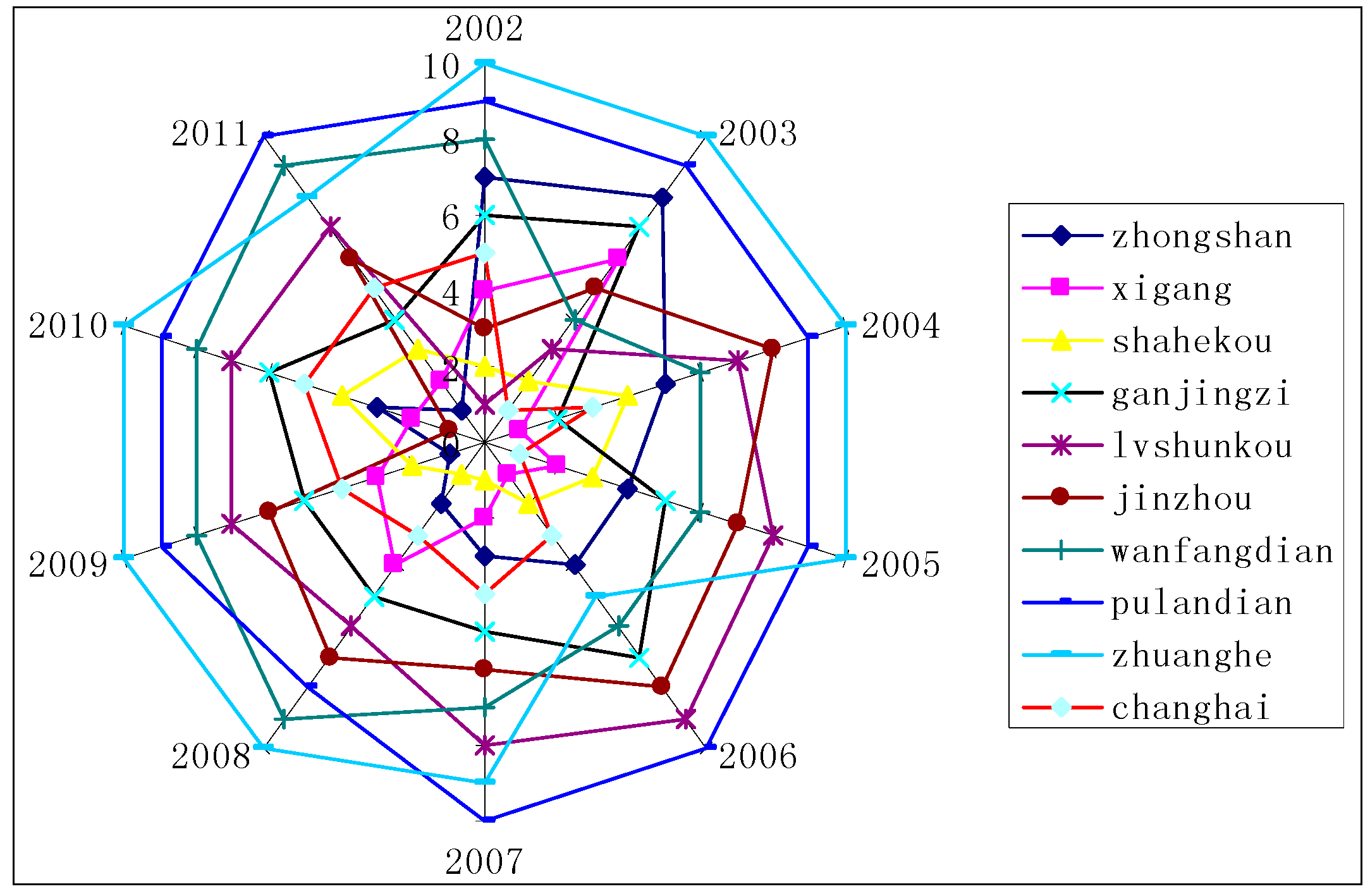
| Year | 2002 | 2003 | 2004 | 2005 | 2006 | 2007 | |||||||
| Regional | score | rank | score | rank | score | rank | score | rank | score | rank | score | rank | |
| Zhongshan | 3.81 | 7 | 3.39 | 8 | 3.86 | 5 | 4.79 | 4 | 4.01 | 4 | 4.57 | 3 | |
| Xigang | 4.32 | 4 | 3.66 | 6 | 5.41 | 1 | 5.29 | 2 | 4.80 | 1 | 4.58 | 2 | |
| Shahekou | 4.62 | 2 | 4.36 | 2 | 4.04 | 4 | 4.86 | 3 | 4.41 | 2 | 5.25 | 1 | |
| Ganjingzi | 4.11 | 6 | 3.50 | 7 | 4.51 | 2 | 3.80 | 5 | 3.07 | 7 | 3.47 | 5 | |
| Lvshunkou | 4.63 | 1 | 4.34 | 3 | 3.53 | 7 | 3.12 | 8 | 2.78 | 9 | 2.70 | 8 | |
| Jinzhou | 4.39 | 3 | 3.80 | 5 | 3.35 | 8 | 3.15 | 7 | 2.88 | 8 | 3.23 | 6 | |
| Wanfangdian | 3.65 | 8 | 3.83 | 4 | 3.68 | 6 | 3.20 | 6 | 3.08 | 6 | 2.79 | 7 | |
| Pulandian | 3.51 | 9 | 2.98 | 9 | 2.92 | 9 | 2.16 | 9 | 2.30 | 10 | 1.62 | 10 | |
| Zhuanghe | 3.34 | 10 | 2.62 | 10 | 2.64 | 10 | 2.58 | 10 | 3.40 | 5 | 2.04 | 9 | |
| Changhai | 4.13 | 5 | 4.76 | 1 | 4.34 | 3 | 5.33 | 1 | 4.37 | 3 | 4.20 | 4 | |
| Year | 2008 | 2009 | 2010 | 2011 | Complex | ||||||||
| Regional | score | rank | score | rank | score | rank | score | rank | score | rank | |||
| Zhongshan | 4.76 | 2 | 5.34 | 1 | 3.93 | 3 | 5.16 | 1 | 4.36 | 3 | |||
| Xigang | 4.12 | 4 | 4.63 | 3 | 4.04 | 2 | 4.92 | 2 | 4.58 | 2 | |||
| Shahekou | 4.88 | 1 | 4.95 | 2 | 3.74 | 4 | 4.75 | 3 | 4.59 | 1 | |||
| Ganjingzi | 3.53 | 5 | 4.09 | 5 | 3.07 | 6 | 4.15 | 4 | 3.73 | 5 | |||
| Lvshunkou | 3.19 | 6 | 3.08 | 7 | 2.86 | 7 | 3.16 | 7 | 3.34 | 7 | |||
| Jinzhou | 3.11 | 7 | 3.19 | 6 | 4.46 | 1 | 3.64 | 6 | 3.52 | 6 | |||
| Wanfangdian | 2.70 | 9 | 2.70 | 8 | 2.40 | 8 | 2.46 | 9 | 3.05 | 8 | |||
| Pulandian | 2.76 | 8 | 2.66 | 9 | 1.95 | 9 | 2.43 | 10 | 2.53 | 10 | |||
| Zhuanghe | 2.12 | 10 | 2.24 | 10 | 1.93 | 10 | 2.49 | 8 | 2.54 | 9 | |||
| Changhai | 4.20 | 3 | 4.49 | 4 | 3.66 | 5 | 3.90 | 5 | 4.34 | 4 | |||
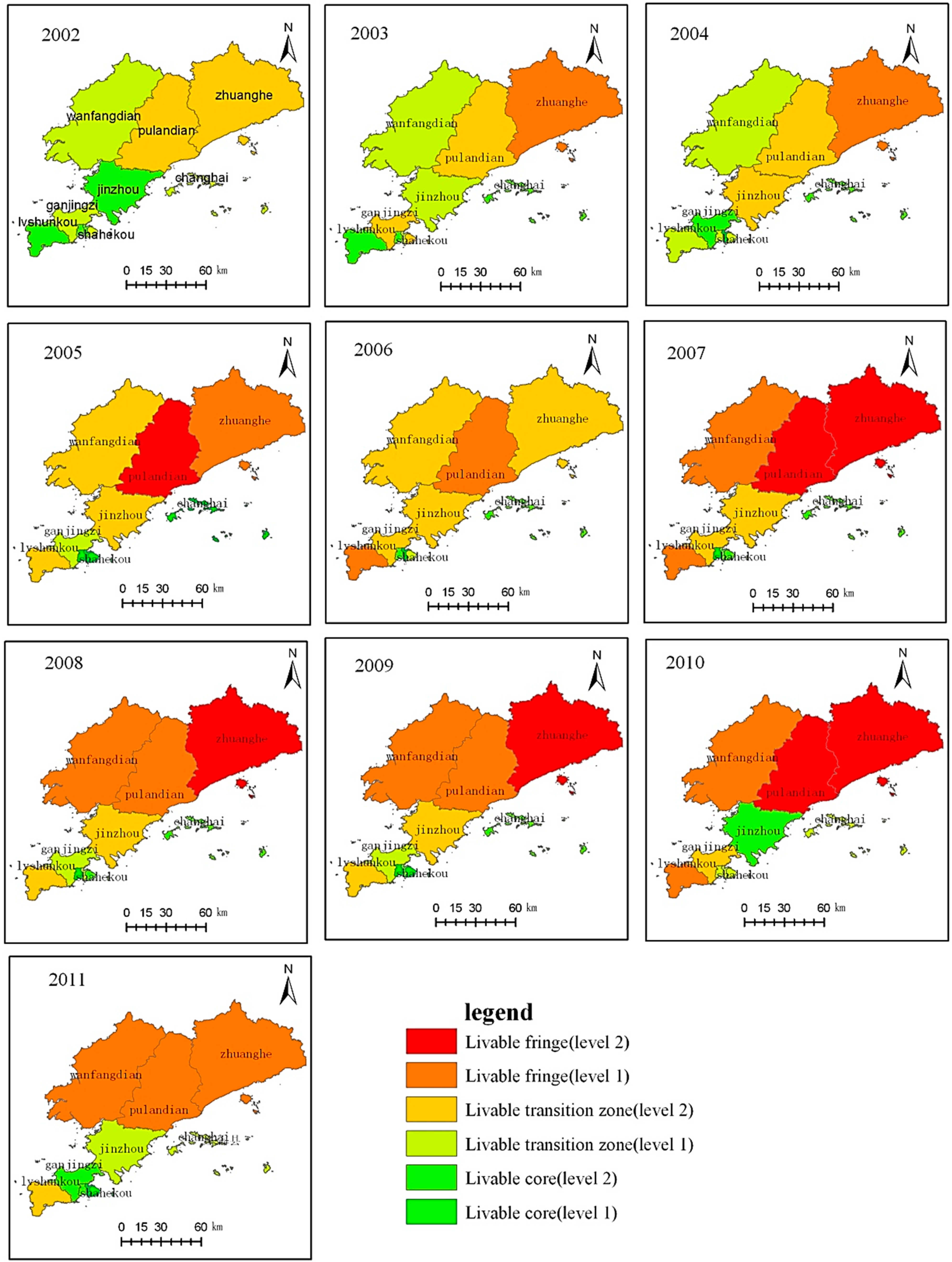
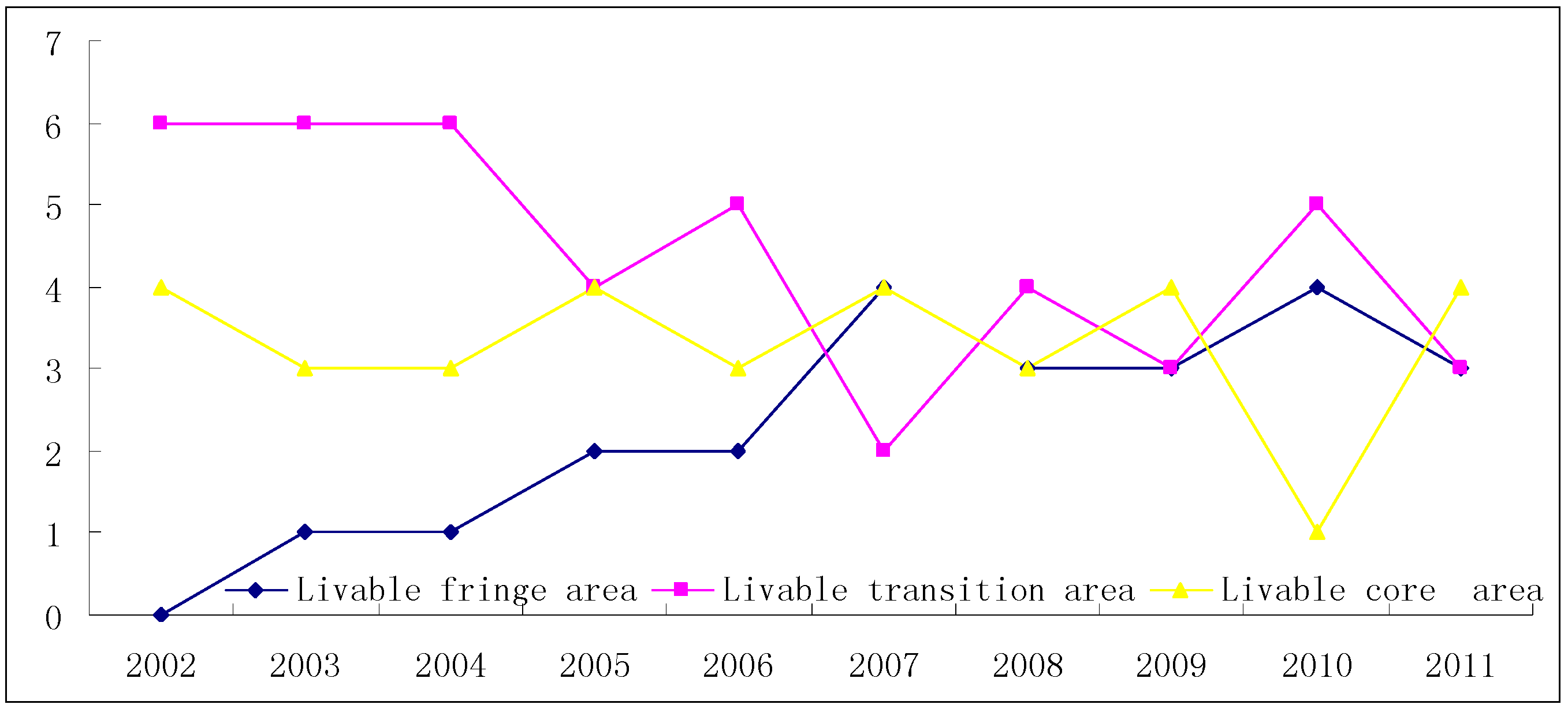
3.1. Triaxiality of Spatial Distribution of Human Settlements
| Unit | Livable Fringe Area | Livable Transition Area | Livable core area | |||
|---|---|---|---|---|---|---|
| Level | Level 2 | Level 1 | Level 2 | Level 1 | Level 2 | Level 1 |
| Standard | 1.17–2.25 | 2.25–2.88 | 2.88–3.52 | 3.52–4.15 | 4.15–4.78 | 4.78–5.41 |
| 2002 | 0 | 0 | 2 | 4 | 4 | 0 |
| 2003 | 0 | 1 | 3 | 3 | 3 | 0 |
| 2004 | 0 | 1 | 2 | 4 | 2 | 1 |
| 2005 | 1 | 1 | 3 | 1 | 0 | 4 |
| 2006 | 0 | 2 | 4 | 1 | 2 | 1 |
| 2007 | 2 | 2 | 2 | 0 | 3 | 1 |
| 2008 | 1 | 2 | 2 | 2 | 2 | 1 |
| 2009 | 1 | 2 | 2 | 1 | 2 | 2 |
| 2010 | 2 | 2 | 1 | 4 | 1 | 0 |
| 2011 | 0 | 3 | 1 | 2 | 2 | 2 |


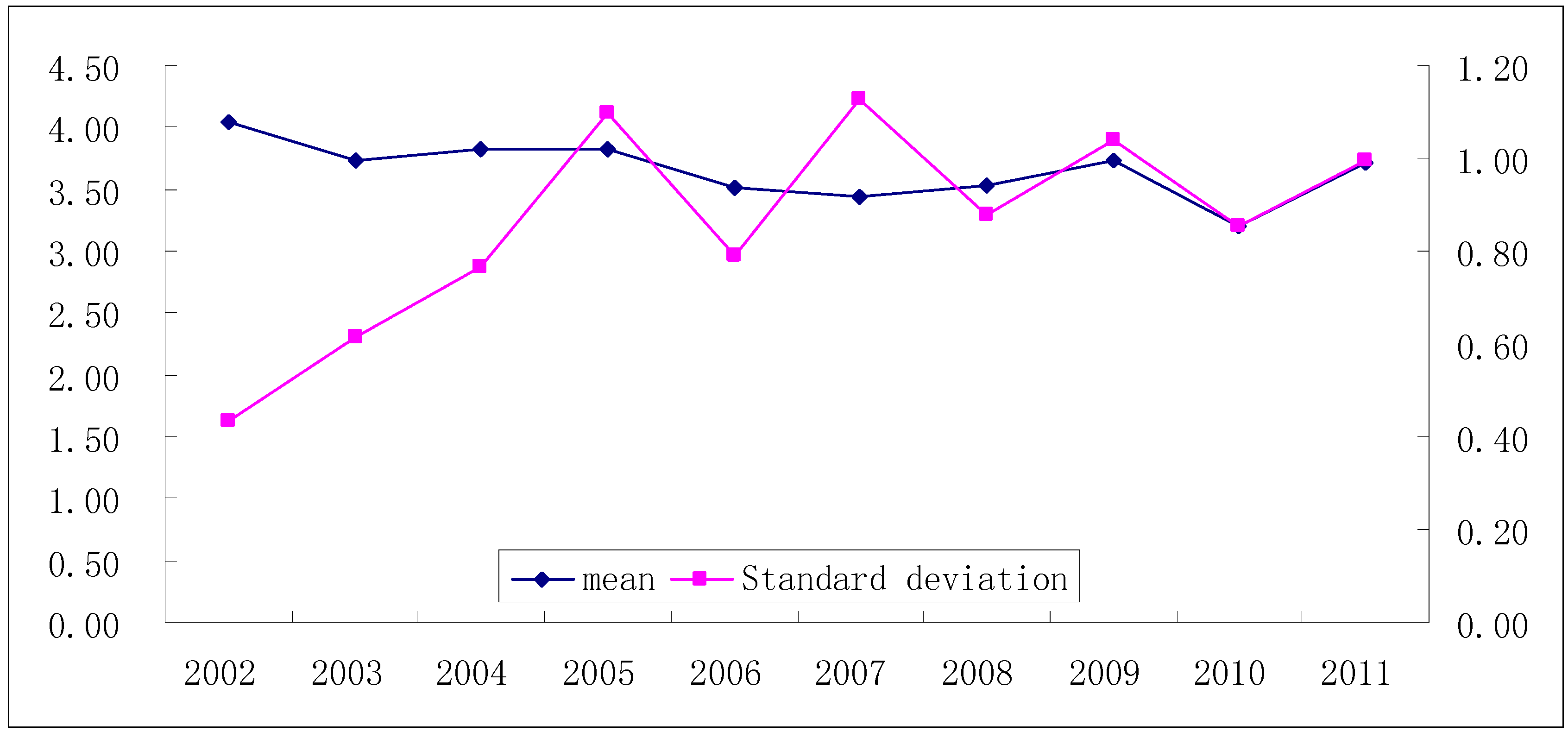
3.2. Triaxiality of Time Evolution of Human Settlements


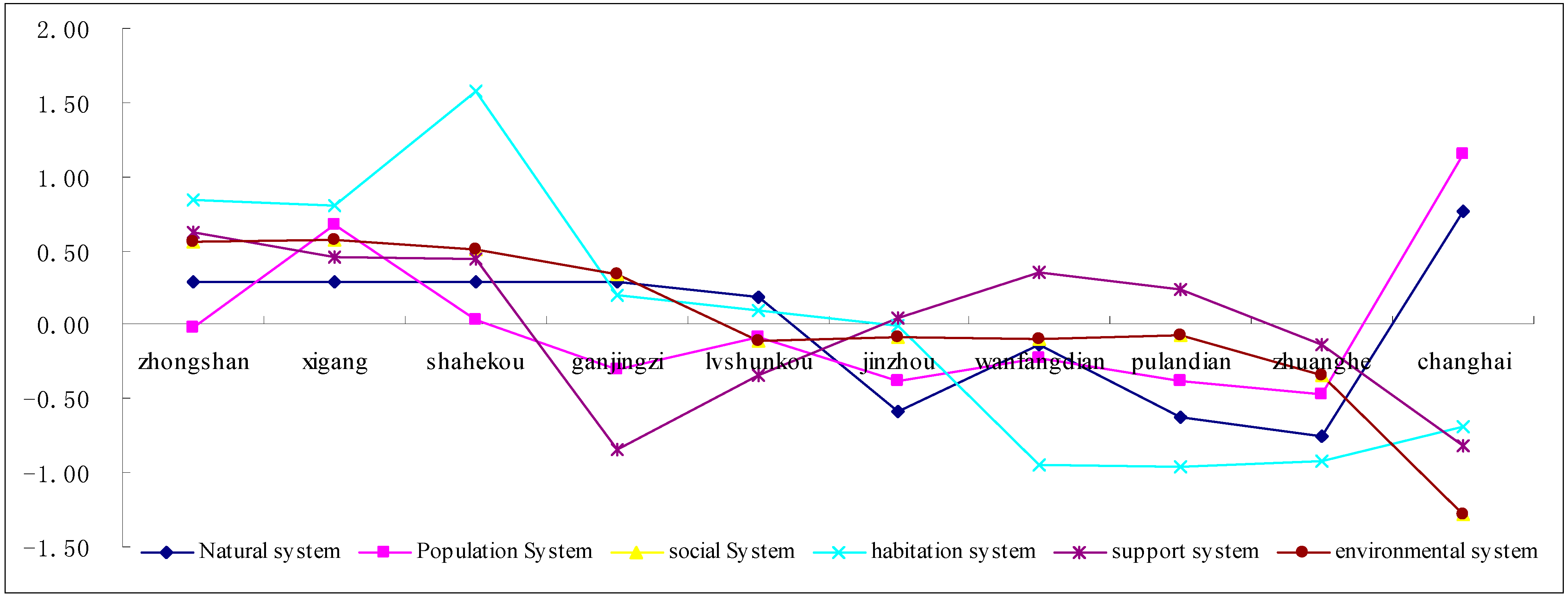
3.3. Triaxiality of System Attributes of Human Settlements

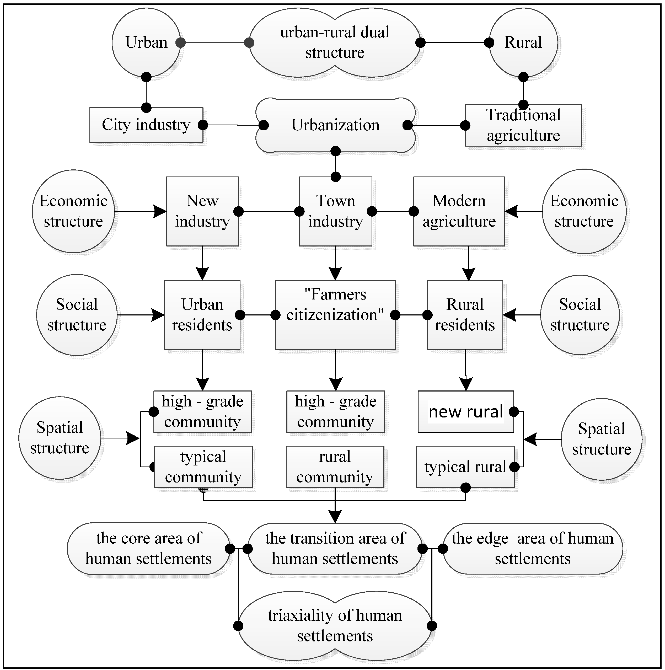
3.4. Formation Mechanism of Triaxiality of Human Settlements

4. Conclusions
Acknowledgments
Author Contributions
Conflicts of Interest
References
- Howard, E. Garden Cities of Tomorrow; The Commercial Press: Beijing, China, 2002; pp. 17–18. [Google Scholar]
- Geddes, P. Cities in Evolution: An Introduction to the Town Planning Movement and to the Study of Civics; China Architecture & Building Press: Beijing, China, 2012; pp. 91–119. [Google Scholar]
- Mumford, L. The City in History: Its Origins, Its Transformations and Its Prospects; China Architecture & Building Press: Beijing, China, 1989; pp. 356–378. [Google Scholar]
- Wu, L.Y. Introduction to Sciences of Human Settlements; China Architecture & Building Press: Beijing, China, 2001; pp. 7–19. [Google Scholar]
- Wu, L.Y. Introduction to Sciences of Human Settlements; China Architecture & Building Press: Beijing, China, 2001; pp. 97–112. [Google Scholar]
- Zhang, W.Z.; Chen, L.; Yang, Y.Z. Research progress on human settlement evolution. Prog. Geog. 2013, 32, 710–721. [Google Scholar]
- McGranahan, G.; Balk, D.; Anderson, B. The rising tide: Assessing the risks of climate change and human settlements in low elevation coastal zones. Environ. Urban. 2007, 19, 17–37. [Google Scholar] [CrossRef]
- Bornstein, L.; Lizarralde, G.; Gould, K.A.; Davidson, C. Framing responses to post-earthquake Haiti: How representations of disasters, reconstruction and human settlements shape resilience. Int. J. Disaster Resil. Built Environ. 2013, 4, 43–57. [Google Scholar] [CrossRef]
- Reed, W.J. On the Rank—Size Distribution for Human Settlements. J. Region. Sci. 2002, 42, 1–17. [Google Scholar] [CrossRef]
- Ouzounis, G.K.; Syrris, V.; Pesaresi, M. Multiscale quality assessment of Global Human Settlement Layer scenes against reference data using statistical learning. Pattern Recogn. Lett. 2013, 34, 1636–1647. [Google Scholar] [CrossRef]
- Magadza, C. Climate change impacts and human settlements in Africa: Prospects for adaptation. Environ. Monit. Assess. 2000, 61, 193–205. [Google Scholar] [CrossRef]
- Hamidi, S.; Ewing, R. A longitudinal study of changes in urban sprawl between 2000 and 2010 in the United States. Landsc. Urban Plan. 2014, 128, 72–82. [Google Scholar] [CrossRef]
- Ramos, W.R.; Medeiros, J.F.; Julião, G.R.; Ríos-Velásquez, C.M.; Marialva, E.F.; Desmouliére, S.J.; Pessoa, F.A.C. Anthropic effects on sand fly (Diptera: Psychodidae) abundance and diversity in an Amazonian rural settlement, Brazil. Acta Trop. 2014, 139, 44–52. [Google Scholar] [CrossRef]
- Massey, R.T. Exploring counter-conduct in upgraded informal settlements: The case of women residents in Makhaza and New Rest (Cape Town), South Africa. Habitat Inter. 2014, 44, 290–296. [Google Scholar] [CrossRef]
- Li, X.M.; Xia, C.G.; Zhang, Y.J. Chinese Human Settlement research with Geography Perspective in recent 10 Years. Urban Dev. Stud. 2014, 21, 6–13. [Google Scholar]
- Cong, Y.G.; Xia, B. Study on difference in satisfaction on level on Human Settlements by different social stratums in Guang Zhou. China City Plan. Rev. 2013, 37, 40–44. [Google Scholar]
- Li, X.M.; Jin, P.Y. Characteristics and Spatial-temporal Differences of Urban Human Settlement Environment in China. Acta Geogr. Sin. 2012, 32, 521–529. [Google Scholar]
- Li, X.M.; Zhang, J.L.; Yang, J.; Zhang, L. Analysis of the attraction field of urban human settlements: A case study of Dalian. Geogr. Res. 2012, 31, 1199–1208. [Google Scholar]
- Wang, K.P. Evaluation of urban human settlements livability—A case of comparison and analysis on China’s four municipalities. Econ. Geogr. 2010, 30, 1992–1997. [Google Scholar]
- Hao, H.M.; Ren, Z.Y. Evaluation of Nature Suitability for Human Settlement in Shanxi Province Based on Grid Data. Acta Geogr. Sin. 2009, 64, 498–506. [Google Scholar]
- Li, X.M.; Tian, S.Z.; Yang, J.; Zhang, F.; Kong, F.Q. The preliminary study of mismatch degree of urban human settlements: Taking 14 cities in Liaoning Province as cases. Geogr. Res. 2014, 33, 687–697. [Google Scholar]
- Li, X.M.; Tian, S.Z.; Zhang, F.; Yang, J.; Zhang, C.H. The evaluation of human settlements of urban special functional area scale: Taking 10 universities in Dalian as cases. Urban Probl. 2014, 2, 24–30. [Google Scholar]
- Wang, Y.; Zhao, W.M. Information Theory for Human Settlements Research and Its Info-spectrum Images System. Acta Geogr. Sin. 2012, 67, 253–265. [Google Scholar]
- Xiong, Y.; Zeng, G.M.; Dong, L.S. Quantitative Evaluation of the Uncertainties in the Coordinated Development of Urban Human Settlement Environment and Economy: Taking Changsha City as an Example. Acta Geogr. Sin. 2007, 62, 397–406. [Google Scholar]
- Huang, N.; Cui, S.H.; Liu, Q.M.; Wen, C.; Chen, X.M. Study on the Characteristics of Community Human Settlements in Peri-urban Area during Urbanization: A Case of Jimei District, Xiamen City. Prog. Geogr. 2012, 31, 750–760. [Google Scholar]
- Li, B.H.; Liu, P.L.; Dou, Y.D. Evolution characteristic and micro mechanism of rural human settlement in underdeveloped areas during the transition—A Case Study of Er-Cheng. Hum. Geogr. 2012, 27, 56–61. [Google Scholar]
- Qi, X.H.; Cheng, Y.; Chen, L.; Zhu, Y. The evolvement rules of human settlements system on metropolis fringe: A case study of Guangzhou. Geogr. Res. 2008, 27, 421–430. [Google Scholar]
- Yang, X.Z.; Wang, Q. Evaluation of rural human settlement quality difference and its driving factors in tourism area of southern Anhui Province. Acta Geogr. Sin. 2013, 68, 851–867. [Google Scholar]
- Li, B.H.; Liu, C.M.; Zeng, J.X. An evaluation on the satisfaction degree and optimization strategy of rural human settlements—A Case Study of Jiuheyuan Town in Shishou City. Hum. Geogr. 2009, 24, 28–32. [Google Scholar]
- Li, B.H.; Zeng, J.X.; Hu, J. Progress and Prospects on the Research of Rural Human Settlement Environment. Geogr. Geo-Inform. Sci. 2008, 24, 70–74. [Google Scholar]
- Li, B.H.; Zeng, J.X. Research on Rural Human Settlement Environment Based on the Changes of the Householders’ Spatial Behaviors. Geogr. Geo-Inform. Sci. 2009, 25, 84–88. [Google Scholar]
- Ma, J.J.; Zeng, J.X. Study on the longevity phenomena and human settlements in rural China: Taking Zhong xiang city as an example. Geogr. Res. 2008, 27, 421–430. [Google Scholar]
- Liu, P.L.; Liao, L.W.; Liu, C.L. Urban residential amenity index and its composition factors: The case of Changsha County in Hunan Province. Prog. Geogr. 2013, 32, 769–776. [Google Scholar]
- Wu, Q.; Cheng, J.P.; Zhong, S.Y.; Li, Y. Empirical research of urban human settlement environment elements based on the needs of different subjects: A case study of Xintang Town, Guangzhou. Geogr. Res. 2013, 32, 307–316. [Google Scholar]
- Xu, M.H.; Sheng, S.H.; Bai, X.H. China’s ternary social structure and the integrative development of countryside and city. Economist 2003, 6, 20–25. [Google Scholar]
- Liu, B.Y. The ternary is the philosophical foundation of the human settlements. Planners 1999, 15, 99–102. [Google Scholar]
- Chen, J.Y.; Hu, B.L. China’s ternary economic structure and the surplus labor migration of agriculture. Econ. Res. J. 1994, 4, 14–22. [Google Scholar]
- Li, K.Q. The discussion of Ternary structure of China’s economy. Soc. Sci. China 1991, 3, 65–82. [Google Scholar]
- Zhang, W.Z. Study on Intrinsic Meanings of the Livable City and the Evaluation System of Livable City. Urban Plan. Forum 2007, 3, 30–34. [Google Scholar]
- Gu, E.X.; Luo, Y.M. The science evaluation standard of Livable city. Beijing Plan. Rev. 2007, 1, 7–10. [Google Scholar]
- Lin, Z.M.; Xia, B. Analysis of sustainable development ability of the urban ecosystem in Guangzhou City in the perspective of entropy. Acta Geogr. Sin. 2013, 68, 45–57. [Google Scholar]
- Li, C.X.; Ma, Y.F.; Zhang, Y.; Wei, Y. Dynamic evolution mode of regional dominance indexes of Chinese in bound tourism flows during 1993 to 2008: An empirical research based on modified entropy technology. Geogr. Res. 2012, 31, 257–268. [Google Scholar]
© 2014 by the authors; licensee MDPI, Basel, Switzerland. This article is an open access article distributed under the terms and conditions of the Creative Commons Attribution license (http://creativecommons.org/licenses/by/4.0/).
Share and Cite
Tian, S.; Li, X.; Yang, J.; Zhang, C.; Zhang, Y. Initial Study on Triaxiality of Human Settlements—In the Case of 10 Districts (Counties) of Dalian. Sustainability 2014, 6, 7276-7291. https://0-doi-org.brum.beds.ac.uk/10.3390/su6107276
Tian S, Li X, Yang J, Zhang C, Zhang Y. Initial Study on Triaxiality of Human Settlements—In the Case of 10 Districts (Counties) of Dalian. Sustainability. 2014; 6(10):7276-7291. https://0-doi-org.brum.beds.ac.uk/10.3390/su6107276
Chicago/Turabian StyleTian, Shenzhen, Xueming Li, Jun Yang, Chunhua Zhang, and Yun Zhang. 2014. "Initial Study on Triaxiality of Human Settlements—In the Case of 10 Districts (Counties) of Dalian" Sustainability 6, no. 10: 7276-7291. https://0-doi-org.brum.beds.ac.uk/10.3390/su6107276