Article

Crowdsourced Geospatial Infrastructure for Coastal Management and Planning for Emerging Post COVID-19 Tourism Demand

by
Efthimios Bakogiannis
,
Chryssy Potsiou
,
Konstantinos Apostolopoulos
and
Charalampos Kyriakidis
*
School of Rural and Surveying Engineering, National Technical University of Athens, 15780 Athens, Greece
*
Author to whom correspondence should be addressed.
Submission received: 14 April 2021 / Revised: 3 June 2021 / Accepted: 7 June 2021 / Published: 12 June 2021

Abstract

:
In recent years, the use of crowdsourcing has positively transformed the way geographic information is collected, stored and analyzed. Many countries have promoted and funded research into the potential of using crowdsourcing in various fields of governance. This paper focuses on developing a methodology for fast, low-cost and reliable coastal management for touristic purposes in Greece. In particular, a group of a professional surveyor have developed the methodology and trained two volunteers to collect a variety of data points of interest about a public coastal zone, such as the area size of free and unused public space, rocky areas, parking spaces (organized or not), land use types, build up and green areas, municipal lighting, pedestrian crossing points, beach umbrellas, path routes, street furniture, etc. A pilot case study was compiled for a part of the Athenian Riviera to check the methodology. Derived conclusions point out that the developed methodology may be successfully used for managing the 16,000 km length of the coastal zone of Greece for touristic purposes. Considerations for further improvements to the methodology are given.

1. Introduction

The coastal zone is usually “home” to a large variety of human activities and facilities [1,2,3,4], such as housing, industry, passenger and freight transportation, as well as sports and coastal touristic activities. Despite the natural beauty, increased human activity and informal development usually has a significant impact on the coastal zone [5,6,7,8,9,10]. For example, the 2018 deadly fires in Attica, Greece, uncovered a significant risk, both for local residents and for tourists, and brought attention to the need for formalization and integrated planning and management of the coastal zone [3,5].
Although (a) a series of directives related to the protection of coastal space have been issued by the EU and the UN and (b) the “Special Framework for Spatial Planning and Regional Development about Coastal Space” have been ratified accordingly by the Greek government, several ad hoc interventions to facilitate increased market and social pressure are usually necessary. Settlements tend to extend in an informal and unplanned manner [11,12]. Such examples in the coastal zone of Greece are present across the country e.g., in Attica, Thessaly, Chalkidiki and on the island of Crete [13]. Unlike European and international trends for marine cadaster and seamless coastal and off-shore management, such geospatial infrastructure is not available in Greece [14]. Even if some spatial data exist, there are significant shortcomings. Planning procedures are complex and bureaucratic and surveying requirements are costly and time-consuming.
The severe economic crisis of the last 10 years, coupled by the pandemic recession, highlighted the need for fast planning for emerging tourist development, especially in the coastal zone. It is anticipated that right after the global lockdown, there will be an emerging increase of tourism, especially in destinations like Greece. The pressure for such preparations is great, as everything should be immediately ready to support increased tourism when travelling safely is possible, in the post-COVID-19 era. However, planning for emerging tourist development during the pandemic period has two major limitations: (a) a significant lack of funding resources and (b) the prolonged lockdown period and social distancing measures.
Therefore, a question arose: “how the needed geospatial infrastructure could be built (a) in a fast manner, (b) from a distance, (c) reliably and (d) at low cost, to enable efficient planning for coastal tourism”. This is the exact objective of this original research presented in this paper. As the current twin challenge of the pandemic, which followed 10 years of significant economic recession in Greece, is brand new, there is limited international literature about the use of crowdsourcing methodologies for tourism management [15] and the contribution of local residents and SMEs (small- and medium-sized enterprises) to planning for tourism commercialization [16], but these could not easily provide an efficient solution to this specific question.
Following this introductory section, an overview of the tourism trends in the region of Attica VGI is presented. In the next section of the literature review, new VGI and crowdsourcing technologies are investigated in terms of supporting a fit-for-purpose solution for updating geospatial data and for building the needed geospatial infrastructure for coastal management and planning for emerging tourism demands. Then, the proposed methodology is analyzed and tested. The geospatial data about the seashore are collected by a group of volunteers in a case study for a part of the Athenian Riviera. Having completed the data collection process, validation of the data was conducted by a professional and completion of the editing phase resulted in a final crowdsourced geospatial map of the area. An assessment of the strengths, weaknesses, and limitations of the proposed methodology are also presented. The conclusion section provides an overarching summary and suggests areas for further work, both in practice and in research.

2. Literature Review

2.1. Tourism Trends in the Region of Attica

Tourism in Greece is based on a “sun lust” tourism pattern, in which tourists choose the destination of their holidays, not in accordance with the particularity of the destination, which is an important motive [17], but rather based on relaxation and on the available vacation facilities. This model is widely applied on the Aegean and Ionian islands as well as to the mainland of Greece, though to a lesser degree, therefore much of the coastal zone of the mainland is still not organized to receive tourists for vacation purposes. However, over the past decade, concerns have arisen regarding the sustainability of such a tourism model [18] because, due to economic, social, ecological, and cultural consequences caused by the massive concentration of tourists [19,20], this resulted in a decline [21]. In addition, the choices of tourists tend to vary since they are interested in authenticity [22]. Thus, while Greek tourism is at a crucial turning point in the Butler cycle [23], new tourism models are sought in order to revitalize tourist movements. A typical example may be cycling tourism, which is promoted in Attica Peninsula.
Another reason that massive amounts of tourism are limited today is the COVID-19 pandemic, which has dramatically changed tourist preferences. The great majority of people prefer to visit destinations where they can be isolated; they prefer to rent small cottages and “Airbnb” rather than to be in large resorts or large-scale hotels on the islands in which there is a large accumulation of visitors and that are only accessible by overcrowded boats. Taking all the above into account, the coastal zone of Attica may attract individual visitors or families who come to Greece for vacations, as it is an easily-accessible destination, close to the Athens Metropolitan Area (AMA) and to the Athens International Airport.
As mentioned above, a large part of the coastal zone of Attica, so far, has not yet attracted much tourism as compared to the islands. Large parts of the coastal zone are not sufficiently organized. Therefore, we chose a part of the Athenian Riviera as a case study area to test our methodology.
Our aim was to develop a methodology using new low-cost technologies and participatory methods for collecting the needed geospatial data infrastructure from the office (no field measurements) that would support fast planning improvements, such as the upgrading of the existing underused assets (such as vacation houses, hotel infrastructure that operates only a few months per year), as well as the coastal zone of the mainland of Greece, by developing needed recreation activities in organized beaches to facilitate emerging tourism demands.

2.2. VGI and Crowdsourcing for Geospatial Information Collection
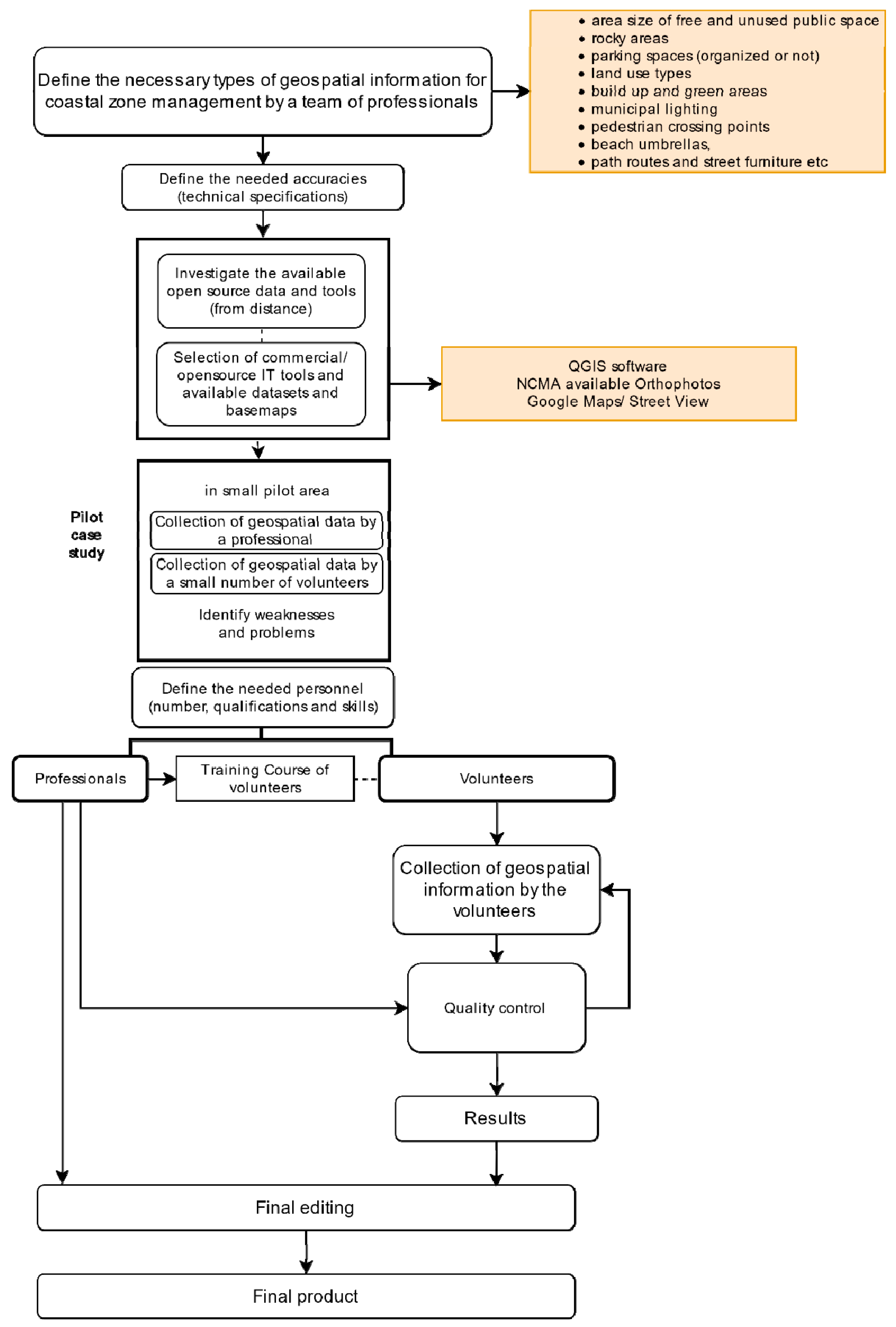
In recent years, the emergence of new technologies has resulted in a disruption of the way planners and surveyors work. Old-fashioned methods began to be challenged and new terminology came to the fore. Neogeography [24], VGI [25], and crowdsourcing [26] are some typical examples of new methods. Neogeography was first described by Eisnor during the 2000s [27,28]. As a concept, it describes the way in which local residents approach their cities [29]; including local residents as well as any volunteer who is engaged in the planning process [30] who were trained in geographic information collection [15]. In this way, local residents and committed volunteers contribute substantially to general project capabilities building by collecting geospatial information through digital platforms and using AI [31]. VGI was presented by Goodchild [25], who defined it as user-generated geospatial content produced to meet various human needs, such as administration, commercial and economical purposes, as well as social networking. According to Goodchild and Li [32], VGI consists of a version of crowdsourcing that, in most cases, has taken the form of georeferenced point- and line-based data, accompanied by a brief textual description, photos, or even videos [33]. According to Surowiecki [26], “under the right circumstances, groups are remarkably intelligent, and are often smarter than the smartest people in them”.
Crowdsourcing seems to be an effective practice for the collection of reliable geospatial information for various land administration and planning purposes [34,35,36,37,38,39,40,41], as well as tourism, heritage, and travel plans [42,43]. Several recent European Commission projects in this field were mainly based on crowdsourcing techniques, in which people are used as “sensors” [44]. Attracting and activating volunteers to participate in various projects by exploring people’s motivations is also a major critical issue for the success of these projects [45].
Such applications are gaining ground as they consist of low-cost solutions for monitoring parameters that are necessary in planning, environmental management land management, as well as fit-for-purpose solutions in land administration [30,38,46,47]. People may participate in them using mobile devices, like smartphones [35,47,48]. Data collection by a volunteer and a large group of smartphone users who are connected to the former is explained by the term “crowdsensing” [49,50,51]. As a result of the Aarhus Convention [52], crowdsensing has been applied in many cases where environmental data collection was needed. Leonardi et al. [53] underlined how this methodology was used to monitor air quality. Bakogiannis et al. [35,36] used this methodology to monitor noise levels, while Rutten et al. [54] studied water management in a similar way.
Supporting the concept of the “wisdom of a crowd”, Criscuolo et al. [55] underlined that local residents can make more reliable assessments than their scientific supervisors due to the fact that local residents are direct observers of the specific phenomena being studied. However, Fonte et al. [56] stressed the need for monitoring data collection processes at various stages to ensure the reliability of data. Validation was also necessary in the project of De Longueville et al. [57], who studied natural hazards with the support of lay people. Bakogiannis et al. [35], through a validation phase, requested the repetition of data collection in some less-centralized areas. Data reliability, the amount and type of data required, the number of engaged volunteers, and the time required to collect the information are critical issues for the planning of each project. Considering that VGI is significantly related to GIS [58], regardless of the way geospatial information is collected, which varies from case to case (e.g., fieldwork, distant data collection, e.g., Google maps, or mixed), questions also arise about the required skills of volunteers, e.g., the extent to which they are familiar with the use of such tools, and their commitment, e.g., how willing and determined they are to be engaged in a project. As shown from the above review, there is no concrete methodology that is similar to the one required, which will easily support a fit-for-purpose solution for updating geospatial data and for building the needed geospatial infrastructure that will allow fast, low-cost and reliable planning interventions to support emerging tourism demands.

3. Methodology

The objective of this paper is to develop a methodology for the remote collection of crowdsourced geospatial information for tourism planning of the coastal zone. To test the methodology, geospatial data about the seashore for a part of the Athenian Riviera were collected by a group of volunteers in a case study. Tourism planning is one of the topics examined at a national level (see [59]) due to the importance of such economic activities for the national GDP [60].
The core elements of this methodology are (a) the identification of the type of geodata that need to be collected, (b) the required geometric accuracies, (c) the identification of the appropriate tools and available open source data that may be used for these kinds of projects, (d) the needed personnel and the number of required volunteers, and (e) the qualifications and skills of the personnel and the volunteers that will be involved in the project, as well as (f) an estimation of the required man-hours.
The first step of this methodology requires an extended and thorough definition of the type of geospatial data that are important and are needed for the project. These data may vary according to the purpose in terms of the various fields of coastal management, such as risk and disaster management [61], human mobility management, real estate management, geoconservation, historical development [62], geoheritage management, and geotourism development [63], as well as planning for emerging tourism activities in new undeveloped areas, such as land use types, hotels, restaurants, bars, sports facilities, housing, schools, demographic data, etc. These datasets may include the following: (a) free and unused public spaces, (b) parking spaces (organized or not), boat storage spots, (c) constructions on the coastal zone (e.g., hotels, bars, restaurants, sport facilities, cinemas/theaters, supermarkets, malls, medical centers/pharmacies, gasoline stations), (d) green areas, rocky areas, (e) municipal lightning and street furniture, (f) pedestrian crossing points, underground crossing points, (g) beaches (organized or not) and facilities for people with special needs, (h) beach umbrellas, (i) access points, road networks, dead ends and path routes, (J) transportation, bus stops, ports, taxi stations (k) municipal authority building, police station, citizen service center, places of religion, (l) port authority, (m) rocky seafront, (n) residential areas, and (o) cultural heritage points of interest (Table 1).
The next step is the definition of the needed geometric accuracies regarding the above-mentioned geo-datasets. These accuracies should be harmonized with technical specifications at the national and EU level (Inspire legislation). As the concept of this research is to collect all data remotely, in the case of Greece, we relied on the accuracy of existing datasets, e.g., available open cadastral maps, high resolution orthophotomaps, etc., which were: (a) orthophotomaps RMSExy < 28 cm for urban areas, and RMSExy < 35 cm for rural areas, and (b) for cadastral maps in urban areas RMSx was ±0.5 m; RMSy was ±0.5 m; and RMSxy was ±0.71 m, while for rural areas the RMSx was ±1.0 m; RMSy was ±1.0 m; and RMSxy was ±1.41 m. This accuracy was sufficient for any task described above. For other countries that lack of such available basemaps, in urgent cases, basemaps from platforms like Google maps or OpenStreetMap, or even simple air photos, may be sufficient.
Having defined the needed geospatial data types and needed appropriate accuracies, the investigation and selection of appropriate IT tools, software, and data that can support and exploit this crowdsourced methodology was done, which were either commercial or open source, although the latter was more preferable. There is a wide variety of open source tools, such as QGIS, OpenStreetMap, and open datasets available online in Greece, such as road and rail networks, main locations of interest (airports, police stations, ports, town halls, etc.), hydrographic networks, coastal line, protected natural areas, Corine land cover, cultural heritage sites, municipal boundaries, demographic data, free Wi-Fi spots, forests, and lakes, which can be used for these kind of projects, positively impacting the work in terms of both their cost and flexibility.
The next important step of this framework was the implementation of a pilot case study with the above-selected geospatial data, defining accuracies and tools in order to identify weaknesses/limitations and problems of the procedure before initializing the project. This pilot case study was conducted by a professional and two volunteers so that various aspects could be investigated regarding the usability of tools, times, costs, achieved accuracies, and collected data.
The definition of the necessary personnel is also crucial for the sustainability of such projects. In order to define the suitable personnel for the needs of the project, two key aspects should be taken under consideration: (a) the number of individuals that should be involved (professionals and volunteers) and (b) their necessary qualifications and skills. The group of volunteers that will participate in the project need to be trained by professionals (surveyors and planners) in a properly designed e-training course. This course should train them on how to use the available IT tools and software, how to identify and digitize the geospatial data on the available basemaps, and how to avoid errors in the process. The professionals are entrusted with quality control and the necessary editing of the crowdsourced geospatial data to produce a final product that will meet all technical specifications. The various steps of the methodology are presented in Figure 1.

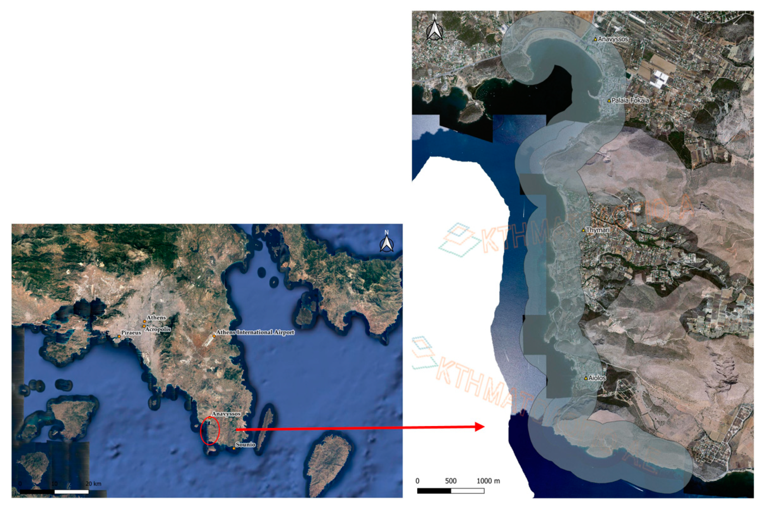
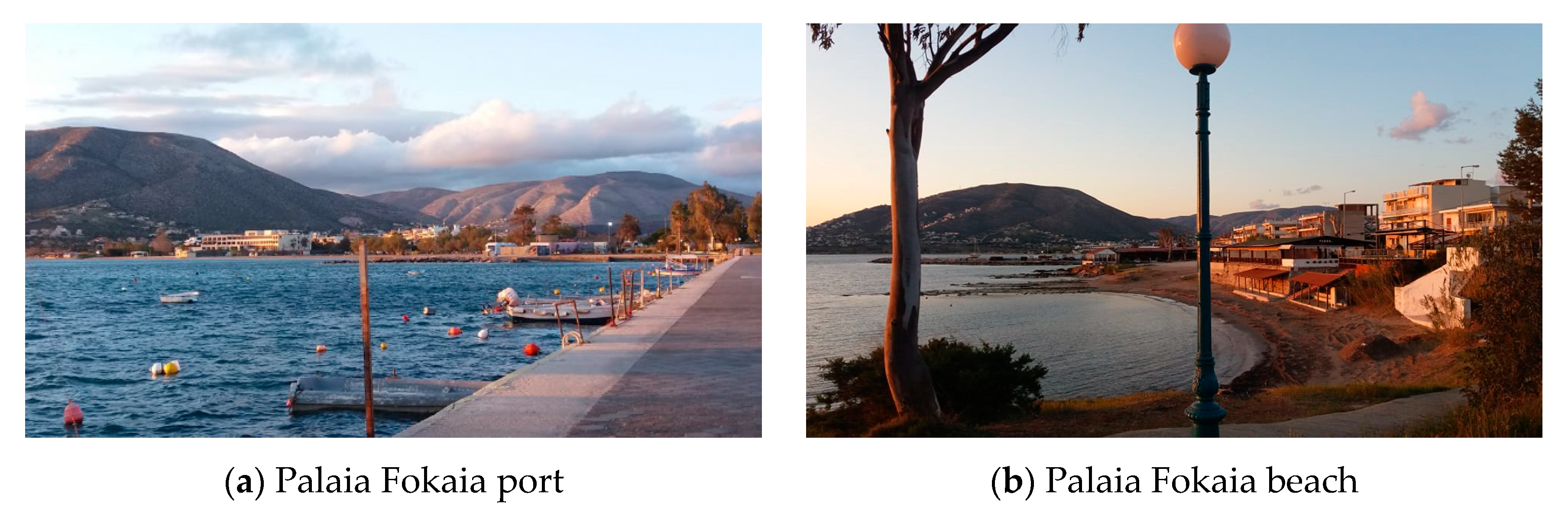
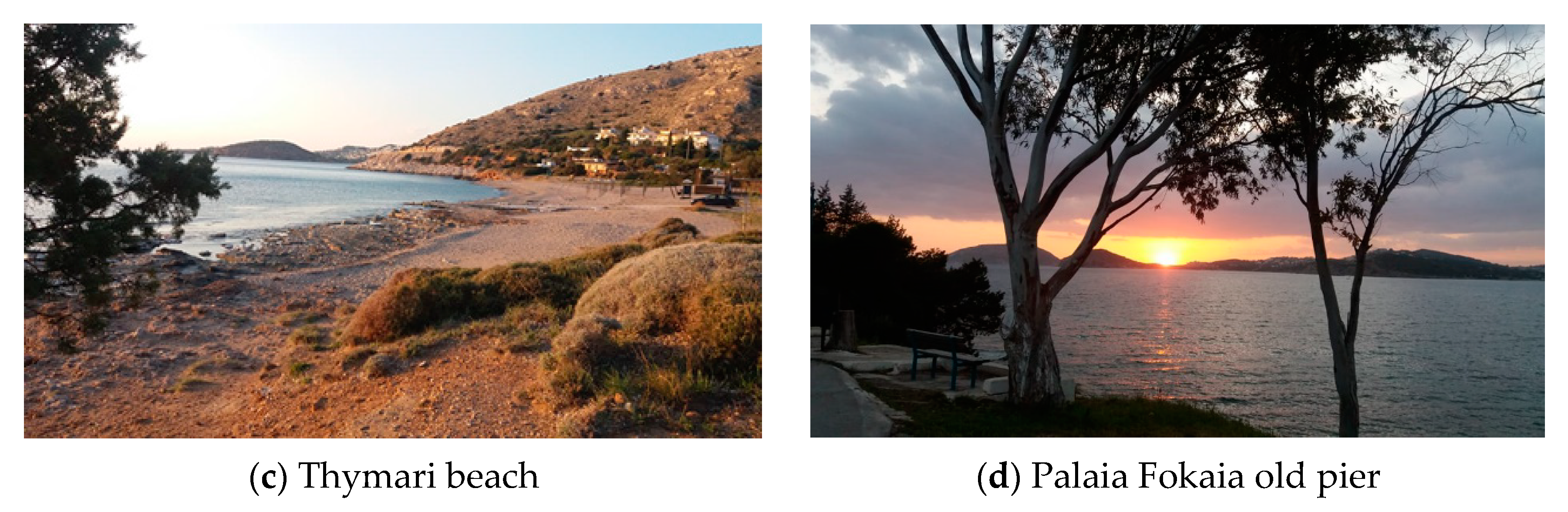
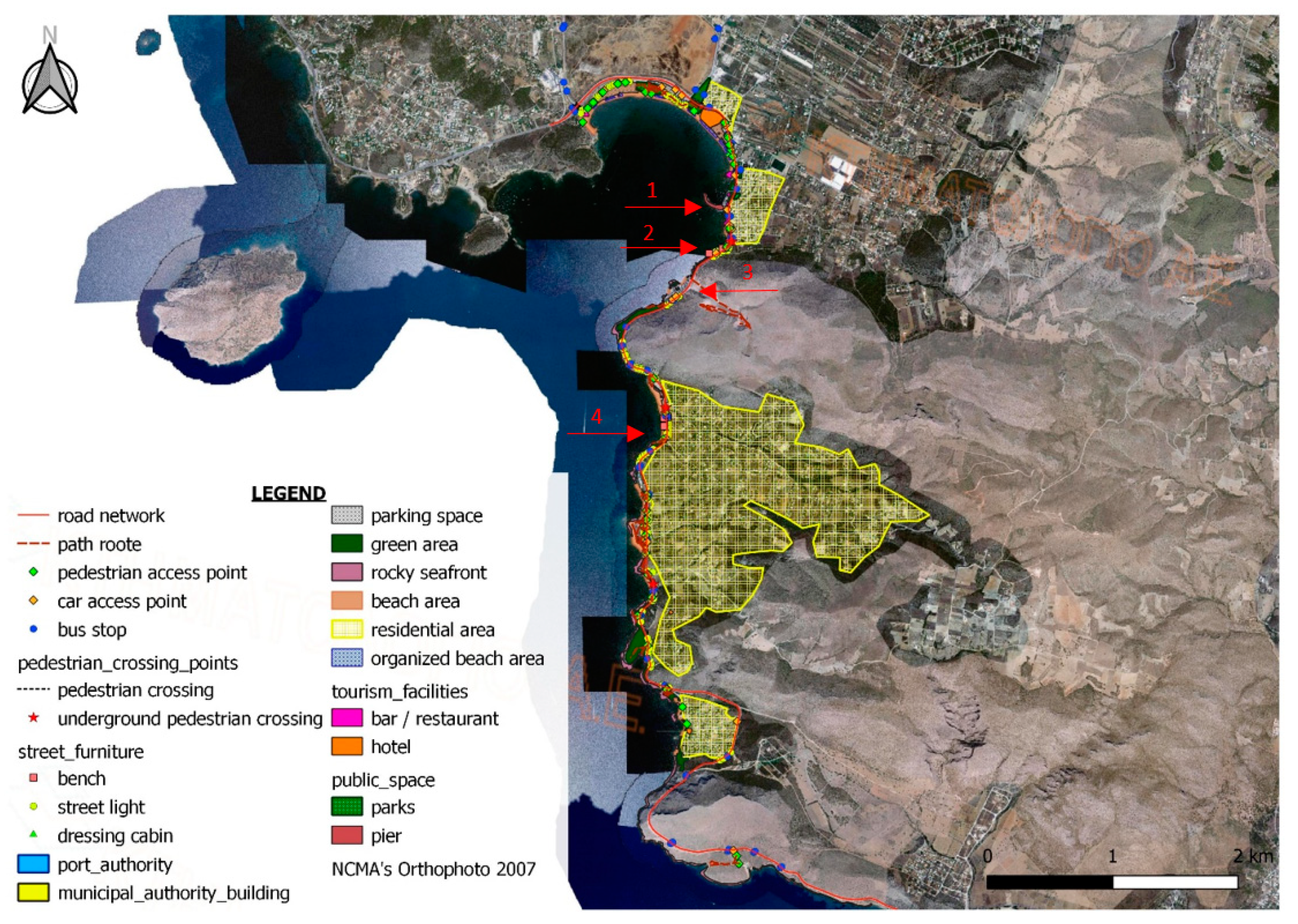
3.1. Defining the Study Area

The implementation of a pilot case study with the above-selected geospatial data, defined accuracies, and tools, allowed the identification of weaknesses in action and problems in the procedure regarding the usability of tools, times, costs, achieved accuracies and collected data before initializing the project at scale.
To test the methodology, a case study was conducted by the authors in a section of the western coastal zone of Attica, Greece, the so-called Athenian Riviera; this zone is currently under a focused upgrading project. This area lies in the southwestern part of the Attican peninsula and includes the Anavyssos, Palaia Fokaia and Thymari beaches, as shown in Figure 2. The main reason for choosing this specific part of the coast is its proximity to the AMA, and its accessibility to tourists who visit both the archaeological sites of ancient Athens and the temple in Cape Sounio. During the summer months, a large amount of daily travel between AMA and the study area takes place, as both tourists and Athenians like to visit these beaches. The study area extends for 11.7 km and the buffer width chosen for the study was approximately 400 m. The total surface of the study area was approximately 4.6 km2.

3.2. Data Collection by the Small Team of Volunteers

At this phase, two volunteers were invited to participate in the data collection workshop. The volunteers, following brief training by a professional, undertook the recording of geospatial data, as mentioned in Table 1. The information was collected using the Google Maps application, specifically the Street View tool. The reasons for not conducting the research with field work was the COVID-19 pandemic lockdown restrictions. The case study was conducted in April 2020. Figure 3 shows views of the case study area; the points where these photos were taken were marked on the final crowdsourced map (points 1, 2, 3 and 4 on the map) (see Figure 6).
Geospatial data are recorded on basemaps, NCMA orthophotos from 2007 that are georeferenced using QGIS software. The procedure of georeferencing was conducted based on the Greek Geodetic Reference System (GGRS87) and, since it was noted that deviations were within the allowed error limits, data were recorded in three shapefile categories (point, line and polygon).
Then, volunteers were informed and trained regarding the geospatial data collection process, as well as regarding its importance. The use of QGIS and Google Maps/Street View tool software was also a part of their training. Motivation for further commitment for voluntary participation was also given. Training duration was about an hour. Then, volunteers started to collect, on their laptops, the needed geospatial information on their own.
The data collection and mapping procedure was timed in order to calculate and compare the working man-hours required for the two volunteers to complete this task. The data collection process was completed within one day by the two volunteers.

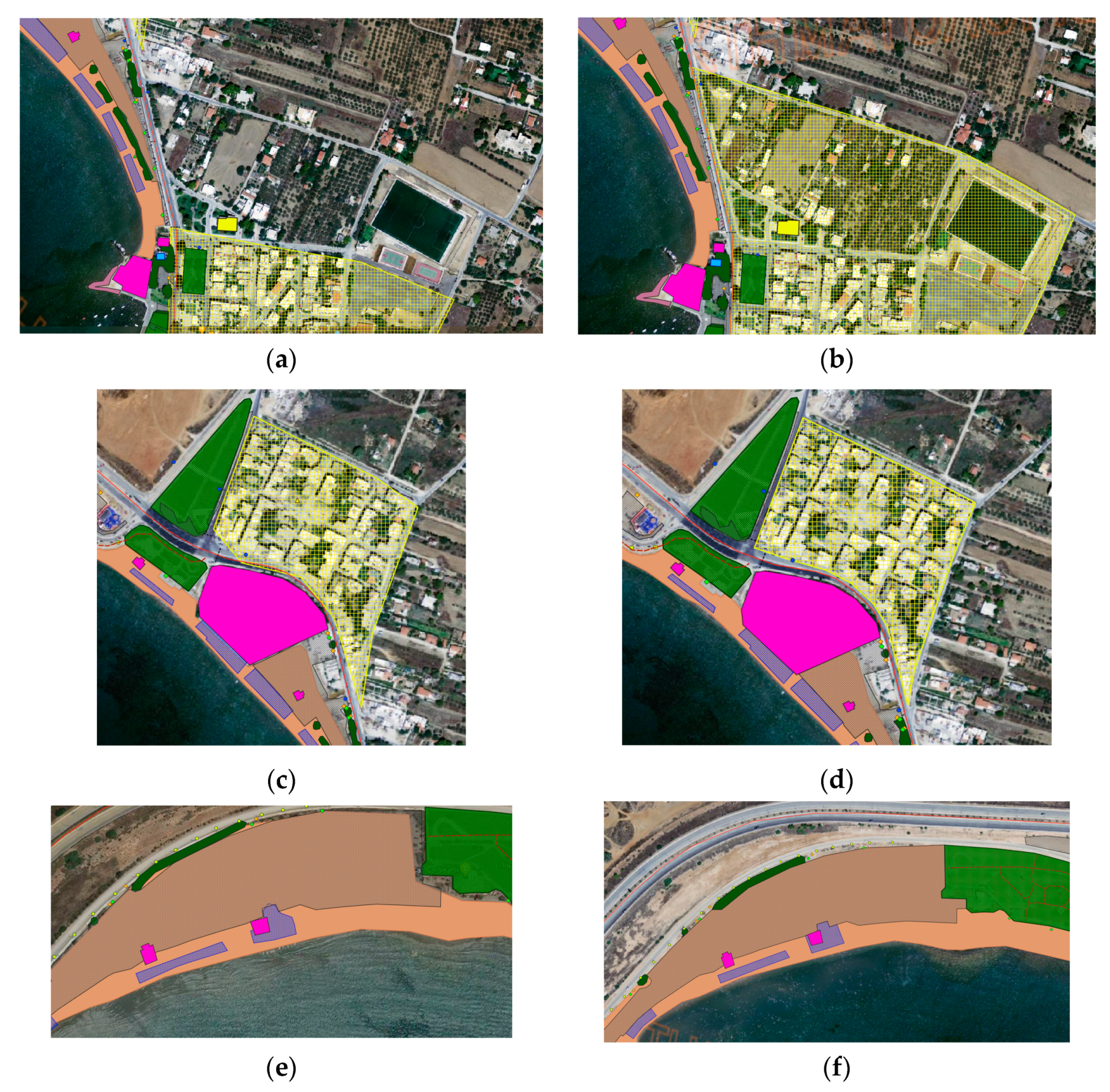
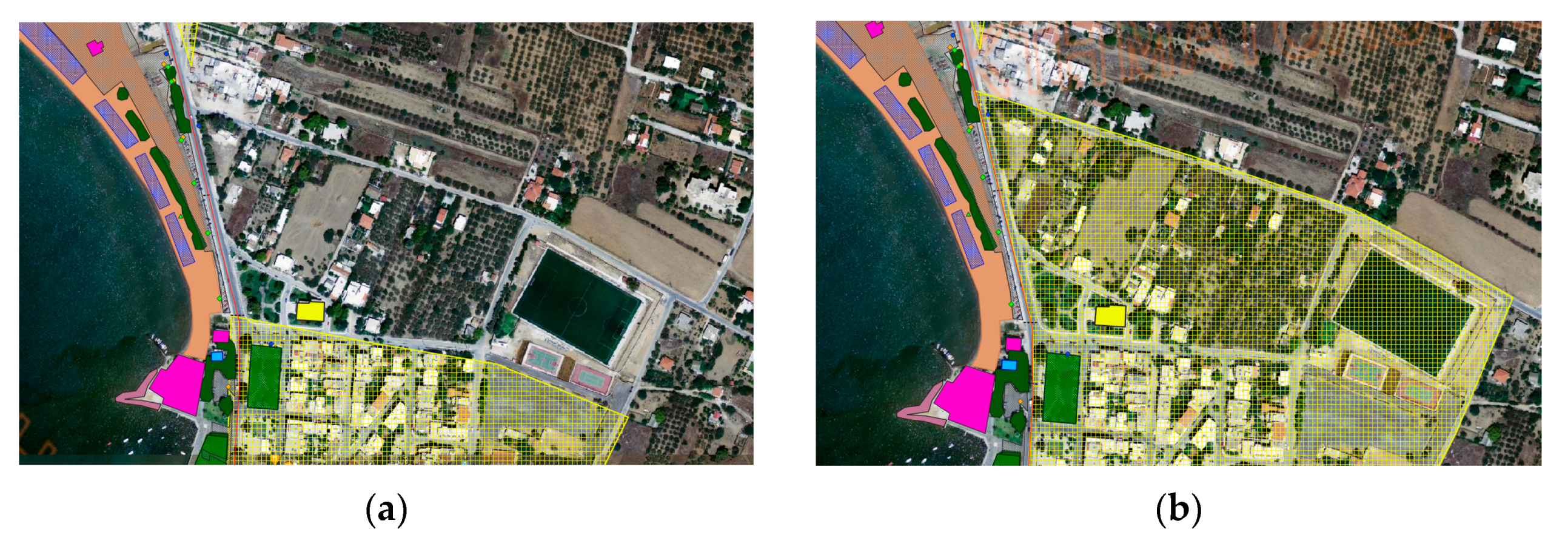
3.3. Quality Control and Editing by a Professional

Having completed the data collection process, validation of the data was conducted by the professional. The professional undertook the quality control and the final editing of geospatial data, were collected by the two volunteers, as mentioned in Figure 1. The professional was qualified for the job of monitoring the collection process remotely and for assisting the volunteers in cases when they needed help.
The editing process by the professional refers mainly to the completeness of the data and to the geometric accuracy of the shape and snapping points of the lines and the polygons digitized by the volunteers. For example, as shown in Figure 4, the volunteers correctly identified but roughly digitized the needed geospatial information; thus, the final geometric accuracy was weak, resulting in gaps between the different layers. This error was corrected and edited by the professional. Another error during the digitization process in the collection phase was the incorrect identification of the Anavissos city plan area (see Figure 5). The professional, knowing the exact boundaries of the city plan area, corrected it by digitizing the missing parts and by correcting the shape of the residential polygon on the basemap. The completion of the editing phase resulted in the final crowdsourced geospatial map of the area (Figure 6).
Man-hours were also recorded. These findings will be discussed in the assessment section.

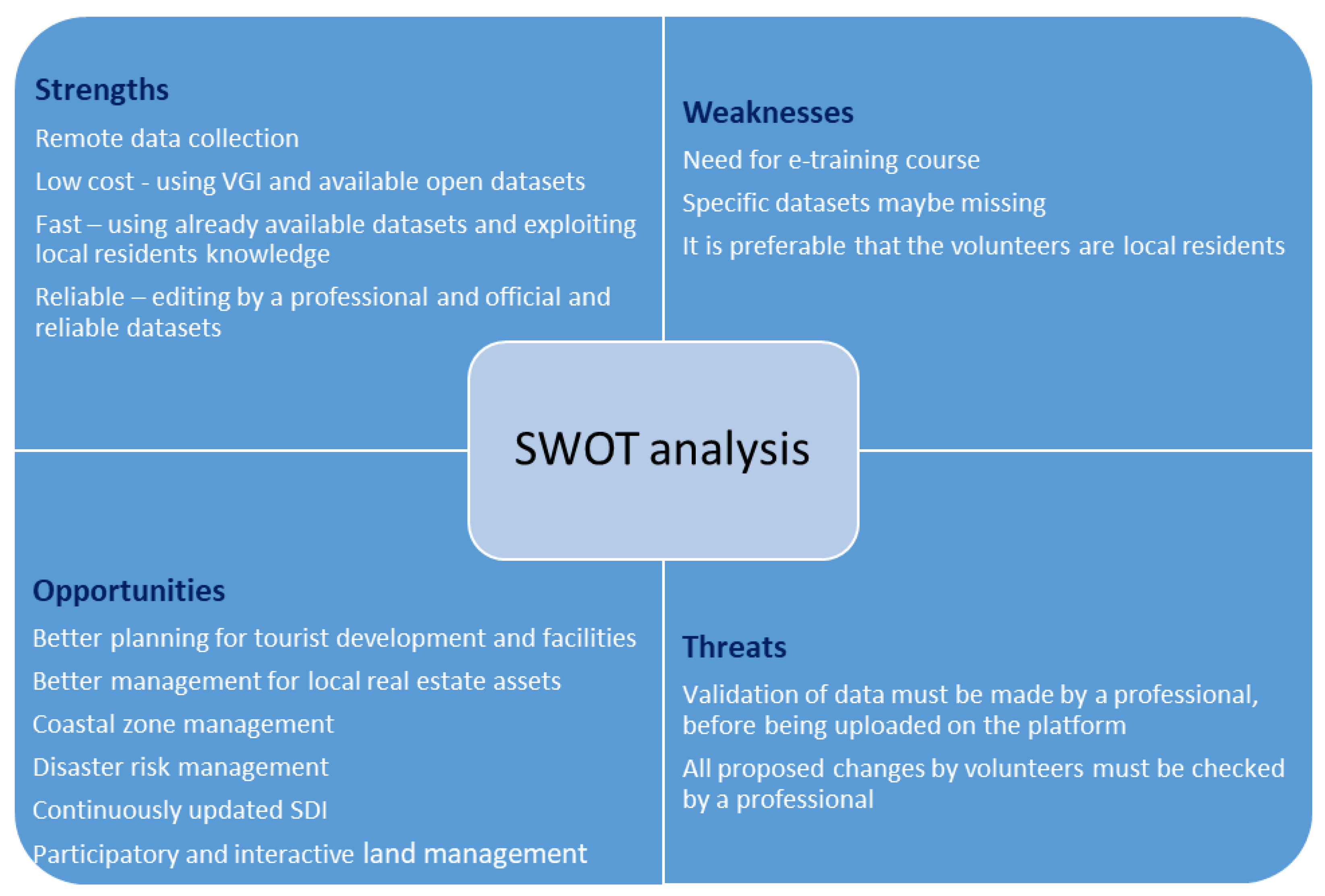
4. Assessment of Strengths and Weaknesses and the Limitations of the Proposed Methodology

At the end of the project, the participatory session was assessed by the volunteers through a questionnaire survey. The questionnaire included 24 open- and close-ended questions that were organized into three sections: (a) personal information, (b) familiarity with technology, and (c) crowdsourcing procedure. The findings helped in producing specific conclusions about the proposed methodology.
Strengths and weaknesses of the proposed methodology were identified at various stages of the research and are presented in a table of SWOT analysis (Figure 7).
Regarding completeness of information, data collection through the Google Maps and Street View apps does not allow the collection of fresh, up-to-date information to the highest degree, as would have been the case if field research had taken place. In areas where information may be hidden, it was recorded by estimation. However, this can always be improved if field visits can be made. Specifically, regarding the completeness of the collected point-data, a few deficiencies were observed. Despite the fact that information, such as street lights, street signs, bus stops, etc., can be easily identified in Google Street View, a few missing points were identified. This was corrected in the editing process.
Regarding the geometric accuracies, the collection of data was done both from various sources with varying accuracies, e.g., georeferenced orthophotos, Street View or Google Maps. The elements derived from Google Maps or Street View, such as the marking of the exact location of a bus stops and of beach cabins on the map scale, which were done approximately, are of less geometric accuracy than the accuracy of the data digitized directly on the orthophotomap. However, such mixed geometric accuracies do not cause a problem and are sufficient for the purpose of the project. Moreover, the required compilation times of such data may vary accordingly, but this does not have much impact on the total time required. In general, the achieved geometric accuracies were considered to be sufficient. Regarding the shape of the various boundary polygons, some problems were identified. The boundary polygons of some surfaces with complex shapes, as well as of areas where parts of the boundary polygon were hidden by a tree canopy, appeared differently on Google Street View and on the orthophoto used. Such details can only be corrected by on-site field controls.
Regarding the distinction of the various data types, a small degree of deviation was noted between the volunteers’ deliverables and the final edited map by the professional. Despite the provided e-course by the professional, the volunteers did not always perceive the various land use types and the geomorphology characteristics of the coastline as required. Volunteers failed to distinguish a park from an open space, for example. The definition of a “beach” was also problematic. This is a sign that the e-training course should be improved.
Regarding the general performance of volunteers, it seems that they had a kind of hierarchy in their minds of what was more important to be digitized according to their personal interests. Apart from what they recognized as worth recording, another criterion was related to their digitization competence, what they understand as “easy to digitize”. In their efforts to compete with each other, speed up, and deliver the best results, the volunteers started the digitization process by recording polygon-data. Next, they decided to record the point-data. They considered point-data to be the most difficult to record as it was not easy to find their exact location on the map. On the other hand, digitization of linear-data was perceived to be the easiest task, which required less time, thus they left it to be done at the end of the process.
Regarding the required time for data collection, the volunteers recorded 14 km2 in 7 working-hours, in total. If the above result was translated in terms of surface digitalized by each volunteer, it was noted that each volunteer recorded 1 km2 in 0.5 h. The professional completed the editing process of the total product in about 2 h (Table 2). This was considered to be a successful result.
Regarding costs, the contribution of volunteers reduced the required costs significantly and the proposed methodology successfully met the objectives of the research.
Regarding the motivation of volunteers, it was declared that their main motivation was their personal interest in contributing to the needs of their country; while they emphasized that, although they had participated in some voluntary activities in the past, neither of them had participated in mapping activities before. All participants considered the proposed methodology important for: (a) the protection of coastal zones; (b) the management and upgrading of real estate—especially informal constructions in this zone; (c) the monitoring of the intensity and the impact of accelerated tourist activity in the respective area; (d) the provision of an updated basemap for municipalities for better planning of future projects, especially under difficult conditions and emergency situations; (e) the provision of a tool for risk management in overcrowded coastal zones; and (f) supporting the seamless management of activities in coastal areas and the marine and off-shore environments. Volunteers expressed their interest in participating in similar projects in the future. They mentioned that the training course helped them in understanding the importance of such activities, which must be further promoted in Greece, so that more people would be engaged. Social media platforms can be useful for this purpose.
Volunteers rated the training course and cooperation with the trainer as good and very good, respectively. It is true that most of the weaknesses mentioned above may be reduced significantly if the e-training course is further improved, according to the findings.
Volunteers considered the use QGIS for data digitization to be easy. In fact, they were familiar with the use of platforms, such as Google Maps and OpenStreetMap (OSM).
In conclusion, the main strength of this method is the fact that it is based on open data sources and has easy-to-use tools and platforms so that the collection of necessary information can be achieved remotely successfully, reliably, affordably, and in a timely manner, even during difficult circumstances, such as a pandemic lockdown, and is much more quickly done than the traditional approach. In addition, if volunteers are interested in a longer engagement with the project, it may also provide a continuously updated tools for fit-for-purpose land administration, as well as for efficient disaster management.

5. Conclusions

The objective of this paper was to develop a methodology using new low-cost technologies and participatory methods for collecting needed geospatial data infrastructure from an office (no field measurements), which would support fast planning improvements, as well as the coastal zone management of the mainland of Greece, and plan for facilitating emerging tourism demands in the post-COVID-19 era.
The pilot study was for an area that was 11.7 km long; and for the task, seven man-hours were needed in total. For developing the needed geospatial data infrastructure for the whole Athenian Riviera, which is approximately 60 km long, it is estimated that 48 man-hours will be needed.
Most of the needed data can be derived from existing open databases for free. Volunteers can collect all needed data remotely, in a fast manner, reliably and at a low-cost.
The professional editing time is estimated to be approx. 11 manhours of office work. The editing included completion of missing data (polygon, linear, point-data) and correction of geometric accuracy of digitization of the various boundaries of shape files. The professional 11 man-hours for editing, the required man-hours for the decisions about the various types of datasets needed for the specific purposes of the project, and the various available sources that will be used and their technical preparations, such as georeferencing of the various datasets (about eight manhours), as well as the preparation of the e-course and the training of volunteers (about eight manhours) should be added.
Through the proposed methodology, the above findings confirmed our theoretical implication that VGI and crowdsourcing, when combined using professional validation of data, can contribute in building the needed geospatial infrastructure for coastal management and in planning for emerging tourism demands at a distance (remotely) in a fit-for-purpose manner, quickly, affordably, and reliably.
The major limitation of the method is the fact that no on-site checking of the collected data was accomplished due to the lockdown restrictions; however, this can be overcome if the volunteers are local residents.
In order to apply this methodology in practice, the authors are in the process of discussing the option of establishing a platform for this purpose and to plan a call for volunteers through social media with the responsible authorities. For the call, several initial thoughts are under consideration and should be further investigated, such as community participation and engagement. It is preferable that the volunteers be committed “local residents” who already know the area well and have an interest for continuously improving the management of “their land”, and can easily visit a site and collect missing data.
Alternatively or additionally, tourists may be invited to participate in such an on-going project during their free time. This could be the basis for an emerging model of participatory tourism. Working from home, tourists may interact in the planning of the area of their preference for vacation. This also allows future visitors to get to know the site well in advance by exploring places remotely and it increases a visitor’s interest in that place.
The evaluation of volunteers is an issue to be further investigated. Methods to attract, and evaluate more skilled and longer-committed volunteers, such as gamification, should be used.

Author Contributions

Conceptualization, E.B. and C.P.; methodology, E.B., C.P., K.A. and C.K.; software, K.A. and C.K.; validation, C.P, K.A. and C.K.; formal analysis, C.P, K.A. and C.K.; data curation, K.A.; writing—original draft preparation, C.P., C.K. and K.A.; writing—review and editing, E.B., C.P., K.A. and C.K.; visualization, K.A. and C.K.; supervision, E.B. and C.P.; project administration, C.P. All authors have read and agreed to the published version of the manuscript.

Funding

This research received no external funding.

Institutional Review Board Statement

Not applicable.

Informed Consent Statement

Not applicable.

Data Availability Statement

Not applicable.

Acknowledgments

The contribution of Konstantinos Apostolopoulos to this research is part of his PhD dissertation, which is supported by the Eugenides Foundation scholarship program.

Conflicts of Interest

The authors declare no conflict of interest.

References

  1. Lainas, I. Land-sea interactions and maritime spatial planning guidelines in the context of European Union. The case of Greece. Int. J. Real Estate Land Plan. 2018, 1, 365–376. [Google Scholar] [CrossRef]
  2. Papageorgiou, M. Coastal and marine tourism: A challenging factor in Marine Spatial Planning. Ocean Coast. Manag. 2016, 129, 44–48. [Google Scholar] [CrossRef]
  3. Iliadis, F.; Kyriakidis, C.; Sioutopoulou, A. Management of the coastal zone: An important issue of modern spatial planning. Studying the case of the region of East Macedonia and Thrace. In Proceedings of the 4th Environmental Conference of Macedonia, Thessaloniki, Greece, 14–17 March 2011. [Google Scholar]
  4. Tang, Z. Evaluating local coastal zone land use planning capacities in California. Ocean Coast. Manag. 2008, 51, 544–555. [Google Scholar] [CrossRef] [Green Version]
  5. Rempis, N.; Tsilimigkas, G.; Pavlogeorgatos, G. Coastal zones and marine spatial planning. The case of the Municipality of Ierapetra, Crete. In Proceedings of the 5th Pan-Hellenic Conference of Planning and Regional Development, Volos, Greece, 27–30 September 2018. [Google Scholar]
  6. Beriatos, E.; Papageorgiou, M. Spatial planning of maritime and coastal space: The case study of Greece in the Mediterranean Sea. In Spatial Planning-Urban Planning-Environment in the 21st Century: Greece-the Mediterranean Sea; Beriatos, E., Papageorgiou, M., Eds.; University of Thessaly Publications: Volos, Greece, 2010; pp. 189–204. [Google Scholar]
  7. Aggelidis, M.; Oikonomou, A. Land uses and effects on the coastal area of Greece. In Proceedings of the HELECO Conference, Athens, Greece, 3–6 February 2005. [Google Scholar]
  8. Potsiou, C.; Dimitriadi, K. Tools for legal integration and regeneration of informal development in Greece: A research study in the Municipality of Keratea. Surv. Land Inf. Sci. 2008, 68, 103–118. [Google Scholar]
  9. Potsiou, C. Informal urban development in Europe. In Experiences from Albania and Greece–Summary Version; FIG/UN HABITAT Publication: Greece, Athens, 2010; p. 121. ISBN 978-92-1-132266-8. [Google Scholar]
  10. Minetos, D.; Polyzos, S.; Sdrolias, L. Social and public responsibility and illegal urban land uses in Greece: An empirical investigation. In Proceedings of the Management of International Business and Economic Systems Conference (MIBES), Larsa, Greece, 4–5 November 2006. [Google Scholar]
  11. Loukogeorgaki, A.; Nikou, M.; Pantazopoulou, D.; Patelida, M. Planning of the coastal space in the era of climate change. In Proceedings of the ERSA-GR Conference, Patras, Greece, 25–26 June 2013. [Google Scholar]
  12. Potsiou, C. Formalizing the Informal: Challenges and Opportunities of Informal Settlements in South-East Europe; UNECE/FIG Publication: New Jork, NJ, USA; Geneva, Switzerland, 2015; p. 121. ISBN 978-87-92853-32-5. [Google Scholar]
  13. Bakogiannis, E.; Kyriakidis, C.; Siti, M.; Eleftheriou, V.; Siolas, A. Urban planning VS environment. Re conciliating the conflicts. In Proceedings of the 4th Pan-Hellenic Conference in Rural and Surveying Engineering, Thessaloniki, Greece, 26–28 September 2014. [Google Scholar]
  14. Barry, M.; Elema, I.; van der Molen, P. Ocean Governance in the Netherlands North Sea. New Professional Tasks. Marine Cadastres and Coastal Management. In Proceedings of the FIG Working Week, Paris, France, 13–17 April 2003. [Google Scholar]
  15. Beiqi, S.; Jinlin, Z.; Po-Ju, C. Exploring urban tourism crowding in Shanghai via crowdsourcing geospatial data. Curr. Issues Tour. 2017, 20, 1186–1209. [Google Scholar] [CrossRef]
  16. Lopes, J.M.; Oliveira, M.; Lopes, J.; Zaman, U. Networks, innovation and knowledge transfer in tourism industry: An empirical study of SMEs in Portugal. Soc. Sci. 2021, 10, 159. [Google Scholar] [CrossRef]
  17. Nunkoo, R.; Ramkissoon, H. Small island tourism: A residents’ perspective. Curr. Issues Tour. 2010, 13, 37–60. [Google Scholar] [CrossRef]
  18. Pavlogeorgatos, G.D.; Konstandoglou, M.E. Cultural tourism: The case of Greece. In Cultural Industries—Procedures, Services, Goods; Vernikos, N., Daskalopoulou, S., Badimaroudis, F., Boudaris, N., Papageorgiou, D., Eds.; Kritiki Publications: Athens, Greece, 2005; pp. 59–85. [Google Scholar]
  19. Andriotis, K. Alternative tourism and its various characteristics. TOPOS Rev. Spat. Dev. Environ. 2003, 20–21, 139–154. [Google Scholar]
  20. Theng, S.; Qiong, X.; Tatar, C. Mass tourism vs Alternative tourism? Challenges and new positioning. Études Caribéenne 2015, 31–32. Available online: https://journals.openedition.org/etudescaribeennes/7708 (accessed on 4 May 2021).
  21. Farmaki, A. An exploration of tourist motivation in rural settings: The case of Troodos, Cyprus. Tour. Manag. Perspect. 2012, 2, 72–78. [Google Scholar] [CrossRef]
  22. Valeri, M.; Fadlon, L. Sustainability in tourism: An originality and hospitality business in Italy. TOURISMOS 2016, 11, 1–18, ISSN 1790-8418. [Google Scholar]
  23. Butler, R.W. The concept of a tourist area cycle of evolution: Implication for management resources. Can. Geogr. 1980, 24, 5–12. [Google Scholar] [CrossRef]
  24. Turner, A. Introduction to Neogeography; O’Reilly Media, Inc.: Newton, MA, USA, 2006. [Google Scholar]
  25. Godchild, M. Citizens as sensors: The world of volunteered geography. GeoJournal 2007, 69, 211–221. [Google Scholar] [CrossRef] [Green Version]
  26. Surowiecki, J. The Wisdom of Crowds: Why the Many Are Smarter than the Few. 2004. Little Brown, NY; London; Toronto; Sydney; Auckland. Available online: https://sentry.rmu.edu/SentryHTML/pdf/lib_finn_DISC8710_wisdom_of_crowds.pdf (accessed on 11 March 2021).
  27. Hacklay, M.; Singleton, A.; Parker, C. Web mapping 2.0: The neogeography of the GeoWeb. Geogr. Compass 2008, 2, 2011–2039. [Google Scholar] [CrossRef]
  28. Stamatopoulou, C. 3D Digital Representation for Utilizing Tourist Routs in the Municipality of Lamia. Mastery Thesis, University of Thessaly, Volos, Greece, 2013. [Google Scholar]
  29. Flanagin, A.; Metzger, M. The credibility of volunteered geographic information. GeoJournal 2008, 72, 137–148. [Google Scholar] [CrossRef]
  30. Bakogiannis, E.; Siti, M.; Athanasopoulos, K.; Vassi, A.; Kyriakidis, C. Crowdsourcing and visual research methodologies to promote data collection for sustainable mobility planning. In Data Analytics: Paving the Way to Sustainable Urban Mobility. Proceedings of 4th Conference on Sustainable Urban Mobility (CSUM2018), Skiathos Island, Greece, 24–25 May 2018; Nathanail, E., Karakikes, D., Eds.; Springer: Cham, Switzerland, 2019; pp. 215–222. [Google Scholar]
  31. Füller, J.; Hutter, K.; Kröger, N. Crowdsourcing as a service—from pilot projects to sustainable innovation routines. Int. J. Proj. Manag. 2021, 39, 183–195. [Google Scholar] [CrossRef]
  32. Goodchild, M.F.; Li, L. Assuring the quality of Volunteered Geographic Information: The nature and motivation of procedures. Spat. Stat. 2012, 1, 110–120. [Google Scholar] [CrossRef]
  33. Coleman, D.; Geogriadou, Y.; Labonte, J. Volunteered Geographic Information: The nature and motivation of producers. Int. J. Spat. Data Infrastruct. Res. 2009, 4, 332–358. [Google Scholar]
  34. Sylaiou, S.; Basiouka, S.; Patias, P.; Stylianidis, E. Volunteered Geographic Information in archaeology. ISPRS Ann. Photogramm. Remote Sens. Spat. Inf. Sci. 2013, II-5/W1, 301–306. [Google Scholar] [CrossRef] [Green Version]
  35. Bakogiannis, E.; Kyriakidis, C.; Siti, M.; Iliadis, F.; Potsiou, C. Toward a methodology for noise mapping using VGI. In Proceedings of the FIG Commission 3 Annual Workshop and Annual Meeting, Volunteered Geographic Information, Lisbon, Portugal, 27–30 November 2017. [Google Scholar]
  36. Bakogiannis, E.; Kyriakidis, C.; Siti, M.; Kougioumtzidis, N.; Potsiou, C. The use of Volunteered Geographic Information (VGI) in noise mapping. In Proceedings of the GeoPreVi 2017, Bucharest, Romania, 14–15 September 2017. [Google Scholar]
  37. Mourafetis, G.; Apostolopoulos, K.; Potsiou, C.; Ioannidis, C. Enhancing cadastral surveys by facilitating the participation of owners. Surv. Rev. 2015, 47, 316–324. [Google Scholar] [CrossRef]
  38. Apostolopoulos, K.; Geli, M.; Petrelli, P.; Potsiou, C.; Ioannidis, C. A new model for cadastral surveying using crowdsourcing. Surv. Rev. 2018, 50, 122–133. [Google Scholar] [CrossRef]
  39. Cetl, V.; Ioannidis, C.; Dalyot, S.; Doytsher, Y.; Felus, Y.; Haklay, M.; Mueller, H.; Potsiou, C.; Rispoli, E.; Siriba, D. New Trends in Geospatial Information: The Land Surveyors Role in the Era of Crowdsourcing and VGI; International Federation of Surveyors (FIG): Copenhagen, Denmark, 2019; Article 73; ISSN 2311-8423. [Google Scholar]
  40. Potsiou, C.; Paunescu, C.; Ioannidis, C.; Apostolopoulos, K.; Nache, F. Reliable 2D Crowdsourced Cadastral Surveys: Case Studies from Greece and Romania. ISPRS Int. J. GeoInf. 2020, 9, 89. [Google Scholar] [CrossRef] [Green Version]
  41. Petrasova, A.; Hipp, J.A.; Mitasova, H. Visualization of pedestrian density dynamics using data extracted from public webcams. ISPRS Int. J. Geo-Inf. 2019, 8, 559. [Google Scholar] [CrossRef] [Green Version]
  42. Zhou, X.; Li, D. From stay to play—A travel planning tool based on crowdsourcing user-generated contents. Appl. Geogr. 2017, 78, 1–11. [Google Scholar] [CrossRef]
  43. Loren-Méndez, M.; Pinzón-Ayala, D.; Ruiz, R.; Alonso-Jiménez, R. Mapping HERITAGE: Geospatial online databases of historic roads. The case of the N-340 roadway corridor on the Spanish Mediterranean. ISPRS Int. J. GeoInf. 2018, 7, 134. [Google Scholar] [CrossRef] [Green Version]
  44. Pödör, A.; Révész, A.; Oscal, A.; Ladomerszki, Z. Testing some aspects of usability of crowdsourced smartphone generated noise maps. J. Geogr. Inf. Syst. 2015, 1, 354–358. [Google Scholar] [CrossRef]
  45. Apostolopoulos, K.; Potsiou, C. Consideration on how to introduce gamification tools to enhance citizen engagement in crowdsourced cadastral surveys. Surv. Rev. 2021, 1. [Google Scholar] [CrossRef]
  46. Basiouka, S.; Potsiou, C. 2012. VGI in cadastre: A Greek experiment to investigate the potential of crowdsourcing techniques in Cadastral Mapping. Surv. Rev. 2012, 44, 153–161. [Google Scholar] [CrossRef]
  47. Bennett, R.M.; Unger, E.-M.; Lemmen, C.; Dijkstra, P. Land administration maintenance: A review of the persistent problem and emerging fit-for-purpose solutions. Land 2021, 10, 509. [Google Scholar] [CrossRef]
  48. Ganti, R.; Ye, F.; Lei, H. Mobile crowdsensing: Current state and future challenges. IEEE Commun. Mag. 2011, 49, 32–39. [Google Scholar] [CrossRef]
  49. Xiao, Y.; Simoens, P.; Pillai, P.; Ha, K.; Satyanarayanan, M. Lowering the barriers to large-scale mobile crowdsensing. In Proceedings of the 14th Workshop on Mobile Computing Systems and Applications, Jekyll Island, GA, USA, 26–27 February 2013. [Google Scholar]
  50. Cardone, G.; Foschini, L.; Bellavista, P.; Corradi, A.; Borcea, C.; Talasila, M.; Curtmola, R. Fostering participation in smart cities: A geo-social crowdsensing platform. IEEE Commun. Mag. 2013, 51, 112–119. [Google Scholar] [CrossRef]
  51. Yang, D.; Xue, G.; Fang, X.; Tang, J. Incentive mechanisms for crowdsensing: Crowdsourcing with smartphones. IEEE/ACM Trans. on Netw. (TON). 2016, 24, 1732–1744. [Google Scholar] [CrossRef]
  52. UNECE. Convention on Access to Information, Public Participation in Decision-making and Access to Justice in Environmental Matters. 1998. Available online: https://www.unece.org/fileadmin/DAM/env/pp/documents/cep43e.pdf (accessed on 7 March 2021).
  53. Leonardi, C.I.; Cappelloto, A.; Caraviello, M.; Lepri, B.; Antonelli, F. SecondNose: An air quality mobile crowdsensing system. In NordiCHI 2014: Proceedings of the 8th Nordic Conference on Human-Computer Interaction: Fun, Fast, Foundational, Helsinki, Finland Duration: 26–30 Oct 2014; ACM: New York, NY, USA, 2014; pp. 1051–1054. [Google Scholar]
  54. Rutten, M.; Minkman, E.; van der Sanden, M. How to get and keep citizens involved in mobile crowd sensing for water management? A review of key success factors and motivational aspects. Willey Interdiscip. Rev. Water 2017, 4, e1218. [Google Scholar] [CrossRef] [Green Version]
  55. Criscuolo, L.; Carrara, P.; Bordogna, G.; Pepe, M.; Zucca, F.; Seppi, R.; Oggioni, A.; Rampini, A. Handling quality in crowdsourced geographic information. In European Handbook of Crowdsourced Geographic Information; Capineri, C., Hacklay, M., Eds.; Ubiquity Press Ltd: London, UK, 2016; pp. 57–74. ISBN 978-1-909188-79-2. [Google Scholar]
  56. Fonte, C.C.; Bastin, L.; Foody, G.; Kellenberger, T.; Mooney, P.; Olteany-Raimond, A.M.; See, L. VGI quality control. ISPRS Ann. Photogramm. Remote Sens. Spatial Inf. Sci. 2015, II-3/W5, 317–324. [Google Scholar] [CrossRef] [Green Version]
  57. De Longueville, B.; Ostlander, N.; Keskitalo, C. Addressing vagueness in Volunteered Geographic Information (VGI)—A case study. Int. J. Spat. Data Infrastruct. Res. 2010, 5, 1725–2463. [Google Scholar]
  58. Brovelli, M.A.; Minghini, M.; Zamboni, G. Public participation in GIS via mobile applications. Int. J. Photogramm. Remote Sens. 2016, 114, 306–315. [Google Scholar] [CrossRef]
  59. Act 4759/2020 for Modernizing the Spatial and Urban Planning Legislation and other Provisions (Government Gazette 245/A/9-12-2020). Available online: https://www.cpalaw.gr/en/insights/newsflashes/2021/01/modernization-spatial-urban-planning-legislation-l4759-2020/ (accessed on 11 March 2021).
  60. Bakogiannis, E.; Vlastos, T.; Athanasopoulos, K.; Christodoulopoulou, G.; Karolemeas, C.; Kyriakidis, C.; Noutsou, M.S.; Papagerasimou-Klironomou, T.; Siti, M.; Stroumpou, I.; et al. Development of a cycle-tourism strategy in Greece based on the preferences of potential cycle-tourists. Sustainability 2020, 12, 2415. [Google Scholar] [CrossRef] [Green Version]
  61. Griffith-Charles, C. Application of FFPLA to achieve economically beneficial outcomes post disaster in the Caribbean. Land 2021, 10, 475. [Google Scholar] [CrossRef]
  62. Oremusová, D.; Nemčíková, M.; Krogmann, A. Transformation of the landscape in the conditions of the Slovak Republic for tourism. Land 2021, 10, 464. [Google Scholar] [CrossRef]
  63. Tessema, G.A.; Poesen, J.; Verstraeten, G.; Van Rompaey, A.; van der Borg, J. The scenic beauty of geosites and its relation to their scientific value and geoscience knowledge of tourists: A case study from Southeastern Spain. Land 2021, 10, 460. [Google Scholar] [CrossRef]
Figure 1. Methodology framework for remote crowdsourced geospatial data collection for coastal management and planning for emerging tourism demand. Source: own elaboration.
Tourismhosp 02 00016 g001
Figure 2. Case study area—a part of the Athenian Riviera. Source: own elaboration.
Tourismhosp 02 00016 g002
Figure 3. Views of the case study area (1, 2, 3, 4 in clockwise order on the map—see Figure 6). Source: Chryssy Potsiou’s Personal Archive.
Tourismhosp 02 00016 g003aTourismhosp 02 00016 g003b
Figure 4. Differences between the initial crowdsourced map (a,c,e) and the final edited map by the professional (b,d,f). Source: own elaboration.
Tourismhosp 02 00016 g004
Figure 5. Differences between the initial crowdsourced map (a) and the final edited map by the professional (b). Source: own elaboration.
Tourismhosp 02 00016 g005
Figure 6. Final edited map of the collected geospatial information of the pilot case study area. Source: own elaboration.
Tourismhosp 02 00016 g006
Figure 7. SWOT analysis.
Tourismhosp 02 00016 g007
Table 1. Types of geospatial data to be collected.
Geospatial Data to Be Collected
Free and unused public spacesGreen areasBeaches (organized or not)
Parking spaces (organized or not)Municipal lightning and street furnitureBeach umbrellas
Constructions on the coastal zone (e.g., hotels, bars, restaurants)Pedestrian crossing pointsRoad network and path routes
Bus stopsMunicipal authority buildingPort authority
Rocky seafrontResidential areaFacilities for people with special needs
Table 2. Required man-hours for data collection and editing for the case study area.
Volunteers (2)
Collection of Data
Professional (1)
Editing
Time (hours)72
Area (km2)1414
Publisher’s Note: MDPI stays neutral with regard to jurisdictional claims in published maps and institutional affiliations.

