Article

Conflicts about Urban Green Spaces in Metropolitan Areas under Conditions of Climate Change: A Multidisciplinary Analysis of Stakeholders’ Perceptions of Planning Processes

1
HEiKA-Heidelberg Karlsruhe Research Partnership, Department of Geography, Heidelberg University, 69120 Heidelberg, Germany
2
HEiKA-Heidelberg Karlsruhe Research Partnership, Institute of Geography and Geoecology (IfGG), Karlsruhe Institute of Technology (KIT), 76131 Karlsruhe, Germany
3
HEiKA-Heidelberg Karlsruhe Research Partnership, Department of Political Science, Heidelberg University, 69115 Heidelberg, Germany
*
Author to whom correspondence should be addressed.
Submission received: 11 December 2018 / Revised: 22 January 2019 / Accepted: 23 January 2019 / Published: 25 January 2019

Abstract

:
Under conditions of climate change, land-use conflicts are a significant challenge for spatial planning, especially in densely populated metropolitan regions. By using a multi-methodological approach, this study aims to identify different stakeholders’ perceptions of these spaces in planning processes within urban areas in Germany. We use an ecosystem service analysis to evaluate the ecological potential of each selected study area and conducted a household survey to gauge how the local population and administration perceive them. The perceptions of these two groups of stakeholders regarding each area’s spatial qualities often differed from their actual ecological potential. We conducted interviews to identify possible conflicts between politicians and administration staff. While cooperation between politicians and the administration staff takes place and works well, the stakeholders involved often evaluate and perceive the cooperation processes in planning differently. Therefore, the authors argue that an integrative and methodologically multi-layered approach is useful for understanding complex perceptions in spatial planning.

1. Introduction

Climate change is playing an increasingly important role in spatial planning research. This is especially true for Germany, where 70% of the population live in cities [1,2,3,4,5,6]. Positive migration rates into cities mostly stem from better job opportunities and better functioning infrastructures. Changes in urban areas to living space and environmental conditions, therefore, affect a particularly large number of people. However, possible solutions that have been tested in these areas can bring about improvements for large sections of society [7].
Climate protection strategies (mitigation) and climate adaptation strategies (adaptation) are developed to counter climate change. Many climate protection and adaptation strategies have direct impacts on spatial structures and thus also on urban regions [8,9]. To tackle climatic challenges, planners focus on blue and green infrastructures, in addition to structural changes and new energy efficiency guidelines for buildings [10,11,12,13]. Green and open spaces, in particular, are climate-relevant areas subject to different urban usage interests. In urban areas, climate-friendly measures are countered by high rents and land prices, a lack of housing space, and limited space in general. Implementing measures for climate mitigation or adaptation in densely populated urban areas is, therefore, fraught with major problems and challenges and requires a reassessment of areas and their potential uses [1].
Research thus far has paid little attention to how different stakeholders perceive and assess green and open spaces. Citizens, politicians, planning administrations, and external service providers are all involved in planning and implementation processes, albeit to varying extents [3]. A deeper understanding of which perceptions these stakeholders hold, as well as the associated procedural conflicts between them, is crucial, but thus far lacking. The research questions guiding this study are: How do different stakeholders perceive and evaluate green and open spaces in metropolitan areas? What role does climate change play in conflicting planning processes?
In recent years, researchers have developed climate protection and adaptation strategies in order to tackle the impacts of climate change [14,15,16]. Spatial climate protection measures include, for example, supporting the reduction of CO2 emissions through a compact settlement structure. In contrast, spatial climate adaptation measures include, for example, supporting the creation of fresh air corridors and creating cooling effects in urbanized areas [6,17,18,19]. These examples show that negotiation processes must take into account a wide variety of interests (i.e., urban densification versus urban open space development). These diverging interests usually manifest themselves in local conflicts over the use of space.
Previous spatial research has shown the implementation of individual climate-relevant measures in cities [10,20,21,22,23]. Other studies have focused on the design of spatially effective instruments—such as development plans for climate change [24], the management of conflicts that have arisen due to competing user interests [25,26,27,28], and the climate effectiveness and cultural-social significance of multifunctional green spaces [29,30]—or looked at problems in the implementation of planning guidelines [31,32,33,34].
As a prerequisite for accepting climate protection measures, the literature also discussed whether as many stakeholders as possible should be involved in the planning process [35,36]. Different stakeholders, however, are likely to perceive area-related measures differently. They assess the costs and benefits of a measure against the background of their individual contexts, which can lead to conflicts that hamper the perception of stakeholders and coordination processes.
A multi-perspective approach to research is a suitable way of mapping how different actors in the planning process perceive and assess green and open spaces. This paper argues that researchers must focus on qualitative and quantitative methods discussing complex problems that arise from spatial planning conflicts between climate mitigation and climate adaptation measures. Therefore, this study employs a seldom-used, methodological approach that combines ecosystem service analysis with supplementary qualitative guideline-based interviews [37,38]. In addition, this paper analyses different important cleavages between stakeholders involved in urban planning processes. Through the application of a multi-methodological approach, this study contributes to research that calls for the inclusion of different knowledges about the ecological potential of urban green and open spaces in the process of planning [39].
The planning process involves different stakeholders and groups of actors who interact with each other: on the one hand, (1) citizens, as residents of the city, are directly affected by planning interventions. Through citizen participation processes, residents bring their individual interests into the planning process. When they concern planning specifications for spatial climate protection and adaptation, communication processes with citizens are given more weight. On the other hand, (2) politicians are legitimized by citizens through elections. While they do place demands on the planning administration, they are likewise the ones who make the final decision on spatial planning measures in municipal council meetings. In doing so, different interests and political issues are weighed against each other in the negotiation processes. The (3) planning administration must handle the demands of both citizens and politicians, in addition to dealing with various other problems, such as rising rents, lack of housing or climate impacts (e.g., urban heat islands and heavy rain events). The task of the municipal planning administration is therefore not only to mediate between citizens and politicians but also to make planning decisions that align with sustainable, socially acceptable urban development and to adhere to the supra-municipal planning principles in accordance with the counter-current principle in Germany [40].
Spatial planning and the local planning administration are dependent on assessments of different planning variants, such as climate effectiveness, environmental compatibility, and the spatial significance of new building blocks. Due to lack of time in municipal planning bodies and/or costly survey methods, assessments are often outsourced to (4) external offices and scientific experts. Conflicts in spatial management of climate change that arise from the implementation of protection and adaptation measures emphasize the importance of coordination and integration within spatial planning [1,2].
Another challenge in the spatial management of climate change is the integration of spatial planning into the multilevel planning system, in which control and coordination options at the municipal level must be coordinated with control and coordination options at a regional level (counter-current principle) [41]. The different levels do not only imply different control possibilities, due to different planning and political legitimation, but also different perceptions of problems. Different stakeholders at the regional and municipal levels can perceive and assess conflicts between climate protection and adaptation measures differently [42,43]. Furthermore, these perceptions and assessments can vary between a single region’s municipalities, population, political actors, and administration [44]. The understanding of horizontal and vertical interaction processes between different spatial entities is especially important in metropolitan regions as they are established to support regional cooperation for strengthening the regional development [45,46,47].
In this paper, we analyze the different stakeholders who participate in and help shape these planning and social processes in metropolitan areas. We focus on climate-ecological assessments and perceptions of green and open spaces in urban regions [10]. The concrete planning of these areas is hampered by various conflicts: (1) conflicts over land use in the implementation of ecologically-defined climate protection and climate adaptation goals; (2) conflicts in the perception of and need for green and open spaces in urban regions by different actors; (3) conflicts in the implementation of measures at local and regional levels. We will process empirically the above-mentioned conflicts in a pilot study using selected green and open spaces in the Rhein-Neckar metropolitan region in Germany. Our multidisciplinary project deals with the “Assessment and Perception of Green and Open Spaces in Urban Regions in the Context of Climate Mitigation and Adaptation (GREIF)” and investigates possibilities for coping with these challenges.
The paper is structured as follows: first, we present the study’s multi-methodological framework and the different methods used. Then, in Section 3, we provide empirical results and answer our research questions in a multi-methodological manner. The discussion summarizes the findings concerning the interlinkages between different research strands as well as the complex relations between various stakeholders and cleavages in climate-orientated planning processes.

2. Materials and Methods

The regional area under study is located in the Baden-Württemberg part of the metropolitan region Rhein-Neckar. We selected three municipalities that represent different types of cities in this metropolitan region: Mannheim, Heidelberg and Weinheim. Not only their different sizes (Mannheim with approx. 300,000 inhabitants; Heidelberg with approx. 150,000 inhabitants, Weinheim with approx. 40,000 inhabitants) but also their different urban characters (Mannheim: industrial metropolis, Heidelberg: service-orientated university city, Weinheim: medium-sized city) have different effects on planning processes. In addition to various problems and amenities, such as the existence of military conversion areas in Heidelberg and Mannheim, for example, demographic characteristics affect the perception of planning processes.
Following consultations with the administrative staff of each city, we selected suitable green and open spaces of different sizes in peripheral urban areas for which no concrete urban land-use planning had (fully) started (Figure 1). We conducted an ecosystem service analysis, a household survey and expert interviews with administrative staff and local politicians in all three cities.

2.1. Ecosystem Service Analysis

Ecosystem services secure and enrich human life [48]. In 2005, the Millennium Ecosystem Assessment assessed the global states of 25 key ecosystem services and classified them into four categories: (1) provisioning services, (2) regulatory services, (3) socio-cultural services, and (4) supporting services. The provisioning services describe goods such as food, medical or genetic resources, materials for clothing, and construction. Regulatory services include energy conversion, climate regulation, and mineralization of organic matter in soil. Socio-cultural services include, e.g., health maintenance, aesthetics, and potential services for recreational use. Supporting services include, e.g., soil formation and nutrition cycling, but are not included in this study [49].
Since landscapes consist of varying ecosystem structures that depend on natural conditions and anthropogenic use, their capacities to offer ecosystem services differ. By analyzing these capacities, it is possible to support planning decisions [50]. In this study, we analyze ecosystem services of urban green and open spaces on a local scale. These are evaluated using the maximum provision of an ecosystem service under given conditions. Since this study assumes that different ecosystems formed under natural or anthropogenic influence alter the supply of ecosystem services, this method is legitimate. The study employs a matrix methodology that highlights both the supply and demand sides of ecosystem services for the selected sites, thereby revealing similarities and differences between the ecological potentials of an area and the requirements and desires from stakeholders.
The study analyses provisioning, regulatory and socio-cultural services offered by the study sites. We selected the following six ecosystem services for analysis: provision of food and crops as well as renewable energy sources (provisioning services), potentials for climate regulation and provision of biodiversity (regulatory services), landscape aesthetics and potentials for recreational purposes (socio-cultural services). We carried out a small-scale analysis for the different forms of land use on the study sites, which were derived from remote sensing data. The study uses data from the Urban Atlas, which provide uniform land use and land cover information for urban regions at a resolution of 50 x 50 meters (0.25 ha) on a European level. The assessment of ecosystem services for the different land uses was based on preliminary studies and literature references. In addition, we collected field data on biodiversity and soil quality on site.
Our ecosystem service analysis is based on the concept established by Burkhard et al. [50], whereby the supply of ecosystem services is assessed in six categories ranging from 0 (=no relevant capacity) to 6 (=maximum relevant capacity). We adapted this approach by reducing it down to categories that range from 0 to 3. This was done due to the fact that it might be difficult for residents to differentiate between seven categories [51].
Each area (Mannheim, Heidelberg, Weinheim) consists of different land use types defined in Urban Atlas. Based on the reported values of Koschke et al. [52], we classified these land use types into categories ranging from 0 (=no relevant capacity) to 3 (=maximum relevant capacity). To represent each ecosystem service and area with just one value, we summed up the categories based on their area-share. Then we grouped these values into equidistant categories ranging from 0 to 3. This enabled us to compare supply and demand of each research area.
Due to changing land use forms, geographical population distributions and other socio-economic conditions, differing demands for ecosystem services from different stakeholders are likely. To determine the demand for ecosystem services, we used selected data from a household survey (see Section 2.2). The respondents were asked individually to assess the importance of ecosystem services on the sites according to the category scheme ranging from 0 (not important) to 3 (very important) (see Appendix A, Table A3). We calculated the mean value for each ecosystem service and re-categorized it according to the same scheme, i.e., from 0 to 3. In addition, we conducted qualitative interviews to gather information on planners’ assessments of the ecosystem services provided by each study area. This made it possible to compare supply and demand for each research area (see Section 2.3).
To determine supply of ecosystem services and the demands by potential user groups and local administration, we then compared both. These differences in supply and demand of ecosystem services can be represented with the matrix analysis [49]. Supply and demand of ecosystem services can be visualized in the form of a budget matrix where the X-axis represents the chosen ecosystem services and the Y-axis shows the existing land use forms of the area in question. Lastly, supply and demand matrices were subtracted to create a budget matrix. The budget matrix illustrates either the excess (supply exceeds demand) or the shortage (demand exceeds supply) of the analyzed ecosystem services [53].

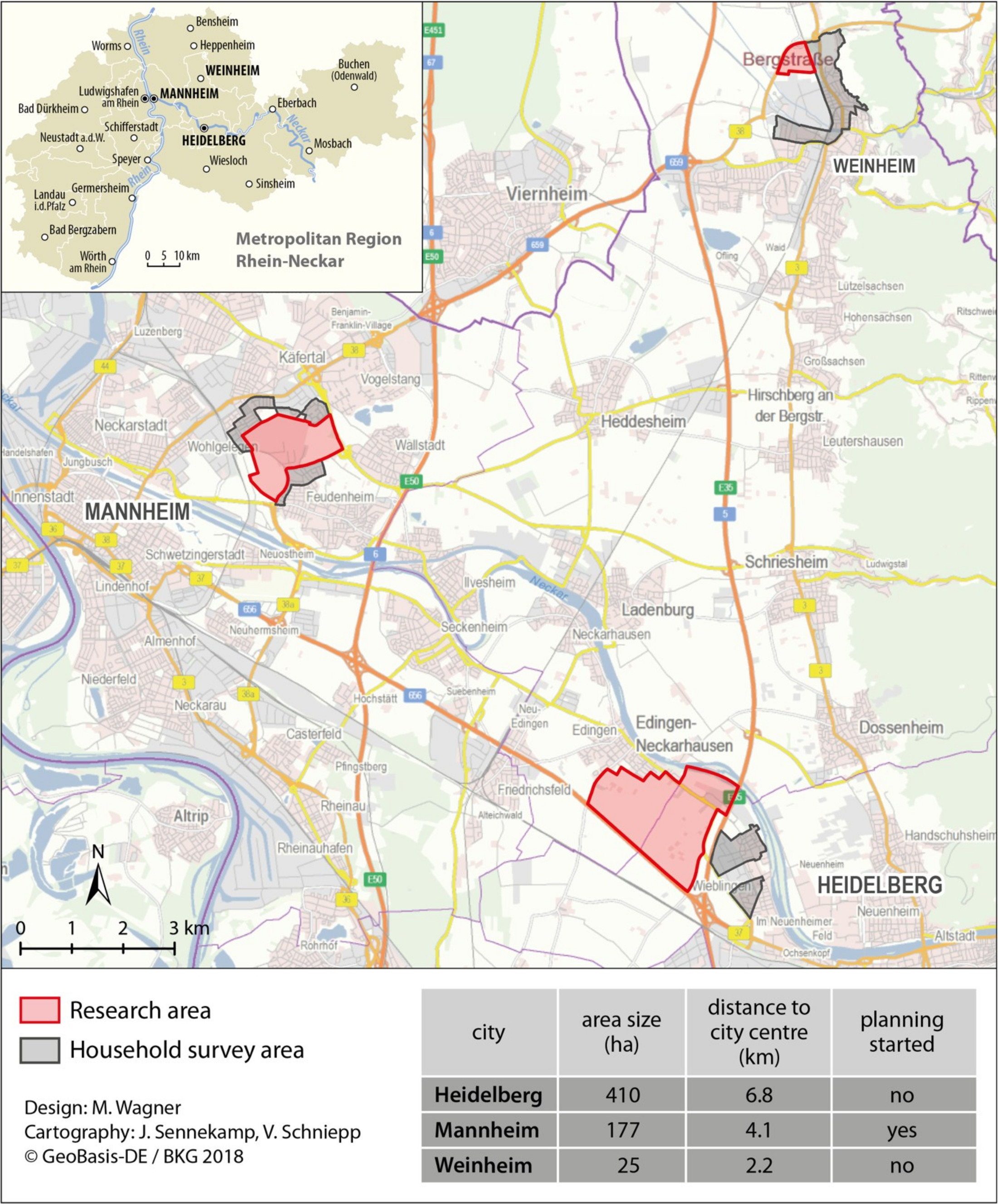
2.2. Household Survey

To explore how citizens used and perceived the study sites, we conducted a household survey in each of the selected cities. Residents directly neighboring the investigation areas were interviewed. To collect the characteristics, perceptions, opinions and behavioral patterns of a larger, selected group of people in a controlled manner, we used a semi-standardized questionnaire. The questionnaire targeted various issues, such as individual perceptions and evaluations of ecosystem services provided by the study sites, as well as actual uses of the areas [54]. Additionally, we surveyed subjective attitudes towards climate change and possible conditions for participating in planning processes (see Appendix A, Table A2). Asking for opinions on competencies and responsibilities in dealing with urban impacts of climate change was also considered worthwhile. Finally, the study collected data on the interviewees’ socio-demographic backgrounds. Each questionnaire was completed in about ten minutes.
We conducted the household survey over four days at the end of October and at the beginning of November 2017. Interviewers approached all households in residential areas directly adjacent to the three areas under scrutiny (see Figure 1). The survey areas had a size of about 1500 to 2000 households per city. A total of 391 questionnaires were suitable for analysis (Heidelberg: 128 sheets, Mannheim: 127 sheets, Weinheim: 136 sheets; return rate of nearly 7%). We coded the gathered information electronically and analyzed it using the SPSS 24 program (provided by IBM Corporation, Armonk, NY, USA).

2.3. Interviews

The study involved conducting semi-structured, qualitative interviews with 28 stakeholders (see Table 1 and in Appendix A, Table A1) in city councils, regional administrative departments, and municipal councils. This implies a qualitative research design based on three case studies in the metropolitan region of Heidelberg, Mannheim, and Weinheim. We interviewed the employees and department managers of different city and regional councils, as well as politicians from the local and regional levels. On the administrative side, we spoke to local and regional stakeholders: twelve of the interviewed stakeholders worked as employees for the city councils in Mannheim, Heidelberg, and Weinheim, two of the stakeholders were employed at the regional association and another two of the interviewees were regional climate managers of the administrative district of Rhein-Neckar and of the bordering district of Neckar-Odenwald.
On the political side, we interviewed eight local politicians from different parties, who were part of the municipal councils or members of the environmental councils (one of them was a member of the Deutsche Bundestag). Four of them came from regional cities adjacent to the case study region.
Using the contact information provided by the regional association and key representatives from the city councils, we ran a snowball sampling system to identify 28 stakeholders, who were subsequently interviewed. This sampling technique is often used to identify actors that are difficult to access for the researchers.
The interviews were conducted in German, the native language of the interviewees and interviewer, and translated into English for this paper. Each of the conducted interviews took between 30 minutes and one and a half hours. All the interviews (save one) were recorded and transcribed. We analyzed the transcripts through a process of coding and categorization of meanings by using the MAXQDA program package (provided by VERBI GmbH, Berlin, Germany). By analyzing the same interview separately and by comparing the coding afterwards, we overcame the problem of intercoder reliability. A code tree was jointly created, which enabled the structured analysis of the interviews. The topics covered included the difference between climate mitigation and adaptation, the perception of green spaces through the eyes of different stakeholders, the planning process in general, and conflicts of use and interest in the planning process.
The interviews started with a relatively open question (‘Could you please tell me about your organizational position in the city council/municipal council?’), then moved on to more specific questions (‘Which stakeholders are involved in the planning process?’) (see Appendix A, Table A4).

3. Results

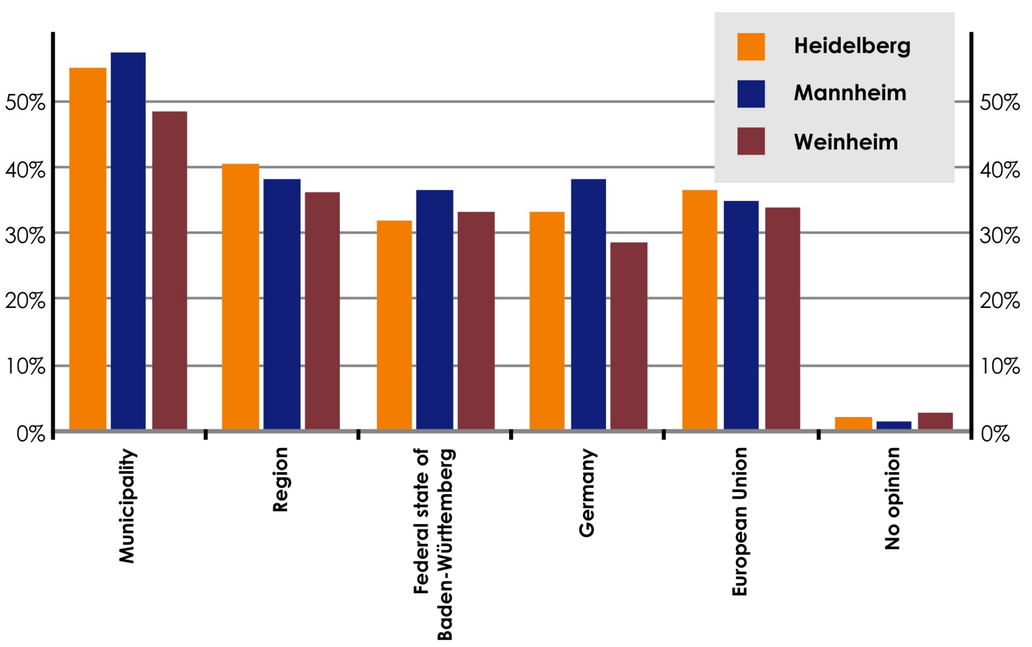
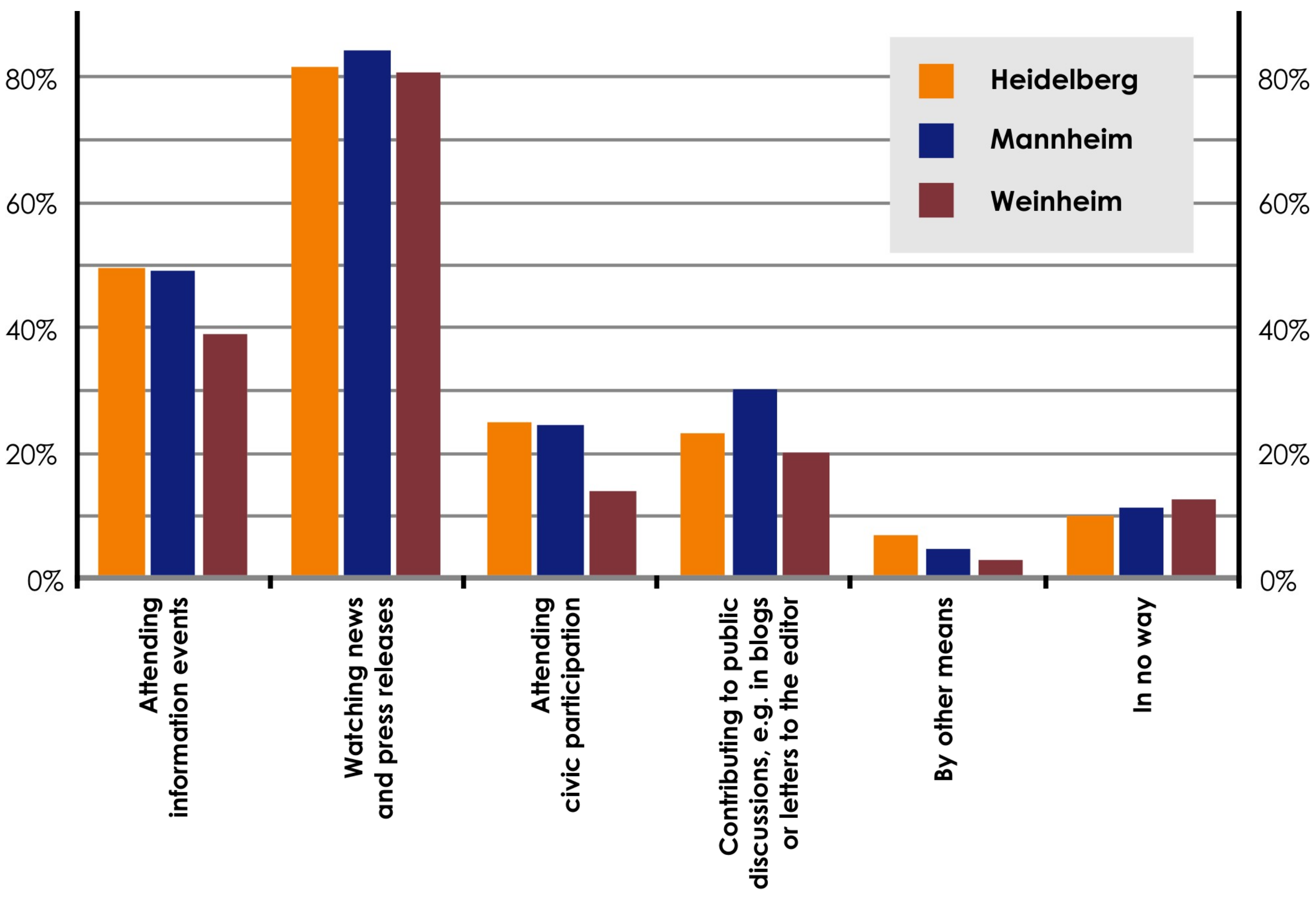
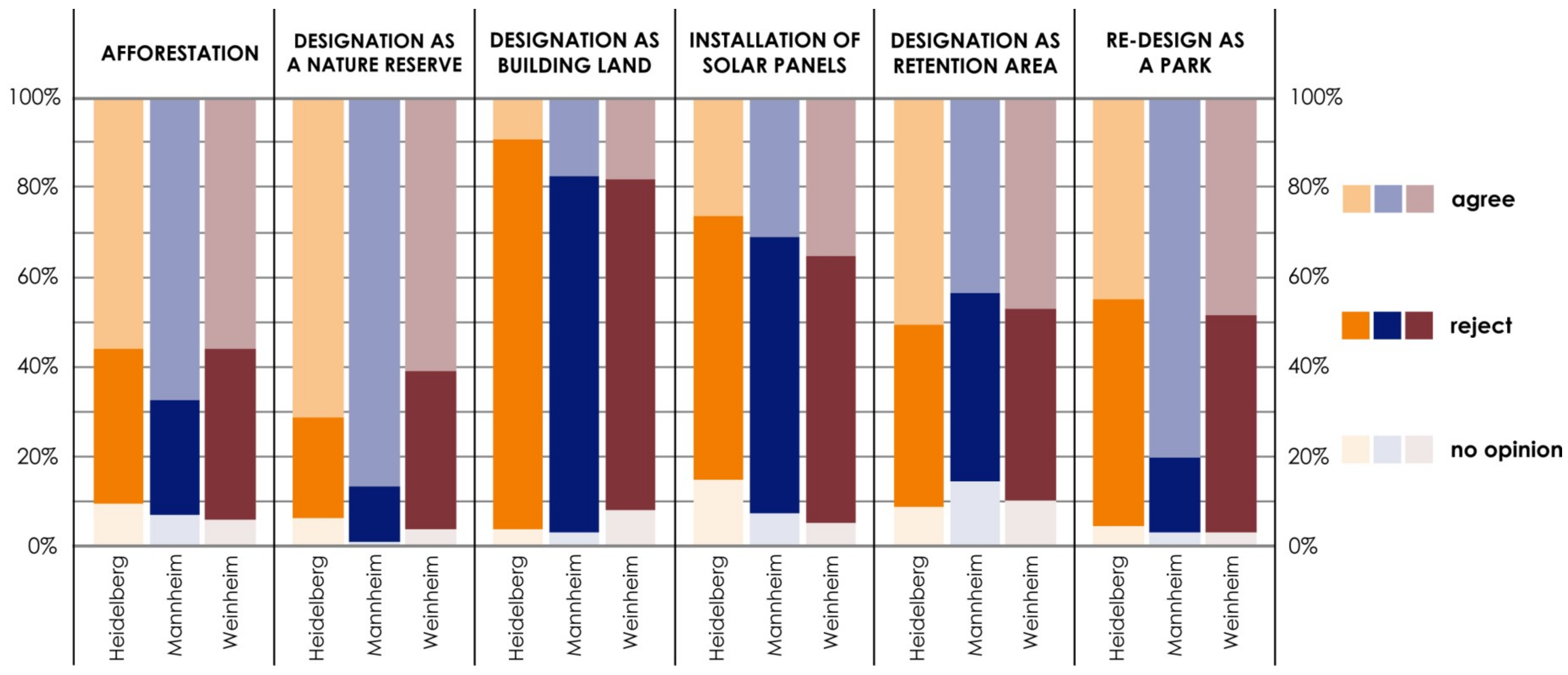
3.1. How Do Different Stakeholders Perceive and Evaluate Green and Open Spaces in Metropolitan Areas?

This section presents results that combine data from the ecosystem service analysis of the study sites, the household surveys conducted to evaluate the perception of these sites, and the interviews with stakeholders.

3.1.1. Supply of Ecosystem Services

The analysis of the ecosystem services provided by the study areas indicates a high potential for climate regulation (fresh air production and circulation) and renewable energy sources, as well as a high degree of landscape aesthetics (characterized by vast open and green spaces) (Table 2). Due to the area’s strong agricultural use, its biodiversity levels are low (no relevant provision of vascular plants). Higher figures for provisioning services in Heidelberg result from lower shares of discontinuous urban fabric, sports and leisure facilities, and roads on the study sites.

3.1.2. Demand for Ecosystem Services

Table 3 illustrates the demand matrix for the selected ecosystem services. Citizens in all three cities requested the ecosystem service ‘biodiversity’ the most, followed by ’climate regulation’, ’aesthetics’, ’food and crops’, and ’recreation’. ’Renewable energy sources’, however, scored a lower demand. Evidently, citizens value ecosystem services that affect their daily lives more highly. In contrast, the planners demand different ecosystem priorities. In Mannheim, the most important services provided by the study sites were socio-cultural services followed by ’climate regulation’. Here, it is important to note that planning processes for this area had already started, including public participation processes and press coverage concerning its possible designation as a local recreation area. This may explain the planners’ preference. In Weinheim, the demand for the area’s ecosystem services is lower. This may be because the area is quite small and is accompanied by adjacent roads, railways and an industrial area site (see Figure 1).

3.1.3. Budgeting Supply and Demand of Ecosystem Services

Table 4 shows the clear difference between the services which each area offers and the citizens’ and interviewed planners’ demands for services. Where the demand of ecosystem services exceeds the supply, values of the budget matrix are negative, as is the case, e.g., for ’biodiversity’. Where the supply exceeds the demand, values of the budget matrix are positive, as can be seen, e.g., for the ecosystem service ’climate regulation’.
The budget matrix shows that ecosystem services have a direct effect on citizens’ lives; corresponding high demand values cause negative values in the budget matrix. Recreational space is in high demand. The ecosystem service ’biodiversity’ shows a significant difference between supply and demand. The preservation of natural surroundings is important for citizens’ well-being, but it cannot be provided by the study site. In contrast, the service ’renewable energy sources’ is provided with high relevant capacities but is not as relevant to citizens.

3.2. What Role Does Climate Change Play in Conflicting Planning Processes?

We now present the empirical results of the household survey and the expert interviews in administration and politics. Concerning the research question of how various stakeholders perceive and evaluate urban green spaces in polycentric urban regions, the results substantiate the empirical results derived from the ecosystem service analysis. The analysis revealed areas of conflict in administration and politics mentioned across all cities, thereby revealing how the perceptions of different stakeholders diverge and where the main lines of conflict lie.
(1)
Cooperation in the Multi-Level System
In Germany, the idea behind having a multi-level system of planning is that it facilitates cooperation between regional planning and municipalities. As the respective levels cover different legally-binding legislative competences, continuous cooperation and coordination between national and supranational decision-makers, and especially between local and regional ones, is essential.
The results of the household survey show how citizens’ perceptions of who ought to assume full responsibility for delivering climate action measures vary. Primarily, citizens believe that the municipal level should bear the main responsibility for deciding on and implementing climate protection measures. However, citizens also see climate protection as an overarching task: the region, the state of Baden-Württemberg, the national level and the European Union are likewise perceived as actors with a certain responsibility. From these results, we can infer that citizens view the local level as a particularly important scale, since the measures in the area of climate protection and adaptation are mostly implemented on the municipal level (Figure 2). However, the regional level, which assumes important roles in planning procedures, particularly in metropolitan regions, is considered less important by the citizens.
(2)
Cooperation between Different Specialist Areas/Stakeholders
Furthermore, cooperation between the individual departments in the planning administration of the cities, as well as between the planning administrations within a region and the individual stakeholders, varies. The multi-level planning system, which is established in Germany, also enables cooperation between regional planning and municipalities, which should complement each other in a counter-current principle [40]. Studies have highlighted the importance of interpersonal relationships in coordination processes [55,56,57,58]. In our study, too, administrations revealed that coordination processes are often based on personal networks:
“There are always people you can do something with. These are your partners. And then you still have to take that political hurdle.” (City Council MA #4)
Regular exchanges or network events can sustain dialogue between municipalities. However, this does not automatically guarantee successful cooperation. For instance, even neighboring municipalities, which have a track record of lively exchange and cooperation in some areas, may not do so in others. A city council representative noted the lack of cooperation in the field of climate adaptation:
“For example, I don’t have any contact with Heidelberg, so there is less cooperation in the field of climate change measures.” (City Council MA #1)
Another aspect which can hamper the planning and negotiation process is the self-interest of the municipalities: “This ‘Kirchturmdenken’ (backyard politics, literally ‘church tower mindset’) of municipalities is quite terrible” (City Council HD #2). This means that municipalities often only think about themselves and do not always share their knowledge with other cities. Politicians evaluate cooperation between planning administrations and politicians as positive; both actor groups as working effectively together. The same is true for how politicians perceive the administration’s work:
“What I’m witnessing is quite good. I never heard our group complain that it was not going well or anything. On the contrary.” (HD #1)
Thus, not only the evaluation and perception of green and open spaces differ from stakeholder to stakeholder but also the assessment of mutual trust. This different assessment of the situation leads to uncertainty, particularly in the planning process, which can have a negative impact on the efficiency and targeting of planning decisions.
To stimulate exchange and cooperation between the stakeholders—i.e., citizens, politicians and administrative staff—districts organize advisory council meetings where they target the formation of political opinion at the individual city’s district level. Such formal meetings have been held regularly in Mannheim since 2014. They are open to the public, and residents are invited to engage directly with each other and different stakeholders. Such district advisory council meetings bring representatives of political parties and of the planning administration together to receive direct feedback from the population.
(3)
Citizen Participation
Cooperation with citizens usually takes place in the form of consultations. Such citizen participation processes are seen by planning administration staff as both helpful and problematic instruments in the planning process. On the one hand, the timely involvement and dissemination of information to citizens is felt to be necessary for preventing possible conflicts. It enables citizens to participate directly in the early phases of the projects, which ensures that their opinions and needs receive serious consideration throughout the various planning phases. On the other hand, administration staff and politicians increasingly criticize the fact that such participatory processes do not (want to) tackle the issues at hand but processes divert from the issue at hand to provide answers for questions which were not asked. Moreover, these meetings take place during the day and usually reach only a certain group of people:
“It’s a bit unfortunate that the same people keep coming over and over again. These are mostly the people who are a bit older, who have time for something like that.” (City Council MA #4)
“I think it is extremely important to involve citizens in such discussions. The whole thing naturally comes up against a limit when citizen participation becomes a policy of prevention.” (HD #1)
Here it must be noted that most citizens do not partake directly in citizen participation procedures, nor express themselves publicly through contributions to discussions. They prefer, for example, to write letters to the editor, as confirmed by the household survey (Figure 3). The focus is much more on attending pure information events or following news in the press. In addition, a certain connection exists between age and length of residency in the cities. Their willingness to participate or provide information coincides with the results of the household survey. In particular, older people, as well as those who have lived in the area for longer, are more likely to get involved in participation processes.
(4)
Insistence on Particular Interests
Administration staff perceive another area of conflict in the planning process to be the citizens’ insistence on particular interests. As inhabitants of the city and partly direct residents and neighbors of the planning projects, all citizens incorporate individual interests into their visions for the planning process. In particular, citizens in the immediate vicinity of the planning project often express reservations and oppose the planning. While citizens generally do not support proposed plans, they do not tolerate them in their immediate neighborhood (NIMBY effect—“Not in my backyard”).
On the other hand, the results of the household survey show that a distinction needs to be made regarding the seriousness of each intervention (Figure 4). Across all three cities, measures that contribute to the conservation or near-natural restructuring of the areas, such as afforestation measures or the designation as a nature reserve, are more likely to be welcomed by the local population. The majority rejects interventions that fundamentally change the appearance and, thus, also the original function of the green space. These include, for example, the designation as building land and the construction of a large photovoltaic system.
(5)
Lack of Trust in the Administration Processes
Another important area of conflict between the various stakeholders in the planning process is the lack of trust in the planning administration. Both politicians and citizens question planning proposals. In essence, they question the administration’s competence to deliver professional expertise. This explains why administrations often (have to) rely on external expert opinions. For instance, to ensure they adhere to legal requirements, such as the integration of environmental aspects into planning processes, administrations often develop planning proposals in conjunction with external stakeholders, such as consultants. They present these proposals at citizen participation events or in municipal council meetings to give them credibility:
“Nevertheless, you always have a negative sign when you come from the administration. […] In other words, we always have to put experts on the side. I take a professor in my arms and say: Here, now come on, let’s do this together or stand up front and tell me what it’s like. […] They don’t believe me, for whatever reason, I have to get a professor by my side.” (City Council MA #4)
In addition to the actors directly involved in the planning process—i.e., citizens, politicians and the planning administration—external knowledge in the form of expert offices are included in the process. In some cases, individual citizen groups or parties commission independent expert opinions, doubting the “external knowledge”. This lack of trust, which citizens and politicians place on planners, also causes resentment and sometimes even resignation in the administration. In addition to providing expertise themselves, administrative staff must commission and evaluate such reports, too:
“When a task is to be solved, it is said: ‘We have to hire an office anyway.’ Then we say: ‘We can do everything ourselves or at least as part of it. We also have people sitting here who are trained.’ But the fact is that the political obstacle is still there.” (City Council MA #4)
The household survey mirrors this aspect. In all three cities, the residents hardly perceived administration and planning staff as suitable actors able to deliver appropriate climate protection measures—though they did attribute competences towards the scientific community, politicians as well as citizens themselves. When it comes to the implementation of local climate measures, the picture is more differentiated: citizens attribute a relatively high degree of capability to the city administration in Heidelberg. In contrast, in Weinheim there is less trust placed in the planning administration (just under 40%). From the point of view of the households surveyed, the responsibility for dealing with such issues lies in the field of politics. Therefore, the aim here must be to strengthen confidence in one’s own planning administration, both from the point of view of politicians and from the perspective of citizens, so that planning processes in the future can be accelerated. This is also true for climate protection interests.

4. Discussion and Conclusion

This paper argues that a multi-level perspective and multi-methodological research approach is helpful for elucidating how different actors in the planning process perceive and evaluate green and open spaces. The combination of different methods was crucial for analyzing the perceptions of various stakeholders, since it allowed us to highlight their different perspectives. Here, the contribution starts with a multidisciplinary, methodological approach. The results show that discussing a complex problem like spatial planning conflicts in the context of climate mitigation and climate protection requires a holistic approach. Moreover, such an approach can show where diverging perceptions and cleavages between stakeholders involved in urban planning processes lie. Therefore, methods like the ecosystem service analysis should be supplemented with qualitative guideline-based interviews so that further conclusions can be drawn regarding the perceptions of different stakeholders.

4.1. Methods

In this paper, we argue that the combining of different instruments and methods is essential for researchers who wish to analyze complex perception processes as well as conflicts between various stakeholders. We applied the method of ecosystem services to the individual study sites in order to evaluate the ecological potential of the respective areas. Overall, the ecosystem service analysis is a flexible method for assessing the environmental potential of specific areas. Moreover, this enables us to sample a variety of ecosystem services that are relevant to the respective project context—such as provisioning, as well as regulatory and socio-cultural services. Furthermore, ecosystem service analysis can quantify not only an area’s environmental potential but also the demand for services and thereby measure the strength of potential conflicts concerning, e.g., open and green spaces. The results of an ecosystem service analysis can help to adapt land-use planning to existing natural conditions and prevailing ecological potentials.
However, other important interests might exist, which cannot be collected through an ecosystem service analysis. To grasp a problem holistically, qualitative methods, such as guideline-interviews, must also be employed. In contrast to the ecosystem service analysis, interviews cannot provide a heuristic evaluation in terms of quantitative evidence but reveal other important lines of conflict by facilitating the analysis of individual in-depth interviews and narrative elements.
Since the present study is, to a large extent, qualitative empirical social research, the results cannot be reproduced in the same way. Although this is a methodological limitation, it did not affect this study, whose aim was to provide results on a case study and to discuss the concept of perception in the context of spatial planning. Furthermore, only qualitative methods could analyze concrete motives for planning processes.

4.2. Content

Concerning the first research question (How do different stakeholders perceive and evaluate green and open spaces in metropolitan areas?), the analysis clarified potential valuation and land use conflicts. Discrepancies were typically found between the study sites’ actual provision of ecosystem services and the respective demands of residents and, to a lesser extent, of the planning administration. Interestingly, citizens are particularly concerned with those ecosystem services that directly affect them as users of the sites—even if the site does not provide them (e.g., leisure and recreational values, high level of biodiversity). From the citizens’ point of view, politicians have, above all, a duty to adopt climate protection measures. Although citizens consider the planning administration to be less responsible and less competent in this regard, they nonetheless deem them capable of implementing these measures, which politicians have adopted in previous city councils. The willingness of citizens to participate in planning processes seems to depend on their immediate concerns. From the administration’s perspective as to why conflicts with citizens arise, resistance is often most voiced by residents living nearby the areas in question, which can be explained by NIMBY effects. Furthermore, administrations deem the inclusion of citizens in participation processes to be expedient in principle but, thus far, lacking. The relationship between the city’s planning administration and its citizens is characterized by their shared perception of the citizens’ lack of trust and lack of confidence in planning authorities. However, broadly speaking, politicians view the cooperation with planning administration generally very positively. Civic participation in the early stages of the planning process is seen as costly but important and transparent instrument, especially for those who will be directly affected.
Adopting a multi-faceted methodological approach also revealed conflicts between the different stakeholder groups. Concerning research question two (What role does climate change play in conflicting planning processes?), we identified five conflict lines: (1) cooperation in the multi-level system, (2) cooperation between different specialist areas/stakeholders, (3) citizen participation (4) insistence on particular interests, and (5) lack of trust in the administration processes. Scale-related lines of conflict between and within different stakeholder groups (politics, planning administration, and citizenship) were less pronounced than expected. Differences in content between, for example, different planning departments and the local policy area were more decisive.
So far, there is little literature on perceptions of ecological potential in planning processes [37,38,59,60]. The stakeholders involved in planning processes—i.e., citizens, administration, politicians and external service providers—are rarely considered together. Instead, the focus is usually on citizens and administration. In Germany in particular, citizen participation has also experienced an upswing in research in recent years. In this context, research should bring perception processes in spatial planning into greater focus.

4.3. Practice

As part of the research project, the authors presented the results in a round table format with planners and politicians from the three cities in question, i.e., Heidelberg, Weinheim, and Mannheim, as well as with regional stakeholders. The presentation of the empirical results and the various methodologies employed triggered lively debates. Appreciation was also shown for the holistic presentation of the problem that it gave to participants. We consider the connection of the natural-scientific and socio-scientific perspectives especially useful, for it had not yet been applied to the areas in question. To underpin the results of this pilot study, further research should investigate the practical application of these methods for other areas.

Author Contributions

Conceptualization: M.W. and C.M.; methodology: M.W., C.M., N.S., and N.K.; Validation: M.W., C.M., N.S., and N.K.; formal analysis: N.K.; Investigation: M.W., N.S., and N.K.; writing—original draft preparation: M.W. and C.M.; writing—review and editing: M.W., C.M., N.S., N.K., and A.G.; visualization: M.W. and C.M.; Supervision: A.G. and C.M.; project administration: A.G. and C.M.; funding acquisition: A.G. and C.M.

Funding

This research was funded by HEiKA-Heidelberg Karlsruhe Research Partnership, Heidelberg University, Karlsruhe Institute of Technology (KIT); Germany.

Conflicts of Interest

The authors declare no conflict of interest.

Appendix A

Table A1. Interview partners.
NumberIntervieweesPublic EntitiesProfession/ FunctionSexInterview Period
City Councils
1City Council MA #1City Council MannheimEmployee of the climate headquarterfemale73 min
2City Council MA #2City Council MannheimProject group conversion—city and regional plannermale73 min
3City Council MA #3City Council MannheimDepartment manager of zoningmale72 min
4City Council MA #4City Council MannheimProject group conversion—city plannermale66 min
5City Council WH #1City Council WeinheimDepartment manager of city development, zoning and spatial developmentmale75 min
6City Council WH #2City Council WeinheimEmployee of the department for environment and green spacesmale53 Min
7City Council WH #3City Council WeinheimDepartment manager of zoning and climate protectionfemale46 min
8City Council HD #1City Council HeidelbergDepartment manager and employee of technical environmental protection and water managementmale*male83 min
9City Council HD #2City Council HeidelbergCity planertown and country planermale*
male
66 min
10City Council HD #3 City Council HeidelbergEmployee of the department city development and statistical analysis, coordination office civil participationmale54 min
11City Council HD #4City Council HeidelbergDepartment manager and employee of economic developmentmale*female51 min
12City Council HD #5City Council HeidelbergEmployee of the department city development and statistical analysis, geographermale48 min
13Regional Association #1Regional Association Rhein-NeckarRegional plannermale88 min
14Regional Association #2Regional Association Rhein-NeckarHead of climate change and regional development, head of regional development and spatial monitoringmale*male56 min
15Administrative district #1Administrative district Neckar-OdenwaldManager of climate protectionmale69 min
16Administrative district #2Administrative District Rhein-NeckarManager of climate protectionfemale*female24 min
Politicians
1MA #1The Green PartyCity Councilor, Municipal Councilfemale55 min
2MA #2The LeftCity Councilor, Environment and Technology Committeemale54 min
3HD #1Christian Democratic PartyDistrict Vice-Chairmanmale51 min
4HD #2Social Democratic PartyHeidelberg Fraction Vice Chair, Planning and Environment Committeefemale48 min
5HD #3The LeftCity Councilormale34 min
6HD #4The Green PartyCity Councilor, Municipal Councilfemalenot recorded
7WH #1The Green Party/Alternative ListMayor male52 min
8MoB #1The Green PartyMember of the Bundestagfemale23 min
9Worms #1Christian Democratic PartyMajor, climate mitigation manager, employee of the environmental service directoratemale*femalemale62 min
10Walldorf #1Christian Democratic PartyMajorfemale52 min
11Leimen #1Free Democratic PartyMajorfemale45 min
12Speyer #1Christian Democratic PartyMajormale76 min
Own illustration. * The interview was conducted with several interviewees from the same department or area of responsibility.
Table A2. Household survey questionnaire (translated). Household Survey concerning green and open spaces in urban housing areas (excerpt). 3. Now I would like to hear your very personal assessment of possible uses of this area. Please indicate whether the aspect mentioned is very important, rather important, rather unimportant, or unimportant for you. How important is it to you that….
(One Cross per Line)Very ImportantRather ImportantRather UnimportantUnimportantDon’t Know
this area supplies agricultural products?
this area is used for the cultivation of plants for energy products (e.g., maize, rape)?
this area provides habitat for various plant and animal species?
plants and water bodies on this area contribute to cooling the environment?
this area offers a beautiful view?
you can relax on this area or you can do sports here?
Table A3. ESD questionnaire (translated, excerpt). In the following questions we would like to ask you for your opinion regarding the importance of certain services and functions that the green area/open space with its surroundings offers or can offer. Are the services and functions from your perspective as a planner very important, rather important, rather unimportant, or unimportant? If you are unable or unwilling to provide any information on an aspect, please tick the “no information” box.
Supply as Performance and Function of the AreaVery ImportantRather ImportantRather UnimportantUnimportantDon’t Know
How important is it from your perspective that agricultural products (cereals, vegetables) can be grown on this land?
How important is it from your perspective that this flat land is used for the cultivation of plants for energy production (e.g., maize, rape)?
Regulation as Performance and Function of the AreaVery ImportantRather ImportantRather UnimportantUnimportantDon’t Know
Plants have a cooling effect on the environment: How important is it from your perspective that this area contributes to cooling the environment in summer?
From your perspective, how important is it that there is a high level of biodiversity on this flat land?
Recreation as Performance and Function of the AreaVery ImportantRather ImportantRather UnimportantUnimportantDon’t Know
How important do you consider the scenic aesthetics/beauty of this area to the residents?
How important is it from your perspective that this area can be used for recreational purposes by residents?
Table A4. Interviewer guidelines (translated, excerpt).
1Overview of task field of a person
2Perception of the area of investigation
3Relevance of the aspect climate protection/climate change of open spaces for politics
4Conflicts between climate protection and climate adaptation in general
5Planning process in general and conflict management
6Communication and perception processes

References

  1. Bundesinstitut für Bau-, Stadt- und Raumforschung (BBSR). Raumordnungsbericht 2011. 2012. Available online: https://www.bbsr.bund.de/BBSR/DE/Veroeffentlichungen/Sonderveroeffentlichungen/2012/rob-2011.html?nn=412542 (accessed on 9 December 2018).
  2. Birkmann, J.; Vollmer, B.; Schanze, J. (Eds.) Raumentwicklung im Klimawandel. Herausforderungen für die räumliche Planung; Forschungsberichte der ARL 2. Akademie für Raumforschung und Landesplanung: Hannover, Germany, 2013. [Google Scholar]
  3. Baasch, S.; Bauriedl, S.; Hafner, S.; Weidlich, S. Klimaanpassung auf regionaler Ebene: Herausforderungen einer regionalen Klimawandel-Goverance. Raumforschung und Raumordnung 2013, 70, 191–201. [Google Scholar] [CrossRef]
  4. Radtke, L.T. Klimawandel in der Landschaftsrahmenplanung. Eine repräsentative Untersuchung zur Berücksichtigung von Klimawandel, Klimaschutz und Klimaanpassung durch Landschaftsrahmenpläne im zeitlichen Verlauf; Bachelorarbeit im Studiengang Landschaftsplanung und Landschaftsarchitektur, Technische Universität Berlin: Berlin, Germany, 2015. [Google Scholar]
  5. Süßbauer, E. Klimawandel als widerspenstiges Problem. Eine soziologische Analyse von Anpassungsstrategien in der Stadtplanung, 1st ed.; Springer VS: Wiesbaden, Germany, 2016. [Google Scholar]
  6. Greiving, S. Klimawandelgerechte Stadtentwicklung. Ursachen und Folgen des Klimawandels durch urbane Konzepte begegnen; ein Projekt des Forschungsprogramms “Experimenteller Wohnungs- und Städtebau (ExWoSt)” des Bundesministeriums für Verkehr, Bau und Stadtentwicklung (BMVBS), betreut vom Bundesinstitut für Bau-, Stadt- und Raumforschung (BBSR) im Bundesamt für Bauwesen und Raumordnung (BBR); Bundesinstitut für Bau-, Stadt- und Raumforschung (BBSR) im Bundesamt für Bauwesen und Raumordnung (BBR), Forschungen/Bundesministerium für Verkehr, Bau und Stadtentwicklung, 149: Bonn, Germany, 2011. [Google Scholar]
  7. OECD. Climate Change Risks and Adaptation; Linking Policy and Economics: Paris, France, 2015. [Google Scholar]
  8. Bundesministerium für Verkehr, Bau und Stadtentwicklung (BMVBS). Heute Zukunft gestalten. Raumentwicklungsstrategien zum Klimawandel. Berlin. 2013. Available online: https://www.bbsr.bund.de/BBSR/DE/Veroeffentlichungen/ministerien/BMVBS/Sonderveroeffentlichungen/2013/Heute_Zukunft_gestalten.html?nn=413102 (accessed on 9 December 2018).
  9. Heinelt, H.; Lamping, W. Wissen und Entscheiden. Lokale Strategien gegen den Klimawandel in Frankfurt am Main, München und Stuttgart, 1st ed.; Campus-Verlag: Frankfurt am Main, Germany; New York, NY, USA, 2015. [Google Scholar]
  10. Rößler, S. Klimawandelgerechte Stadtentwicklung durch grüne Infrastruktur. Raumforschung und Raumordnung 2015, 73, 123–132. [Google Scholar] [CrossRef]
  11. Hertlein-Rieder, V. Grüne Infrastruktur. Zeitgenössische deutsche Landschaftsarchitektur (contemporary German landscape architecture); Birkhäuser: Basel, Switzerland, 2015. [Google Scholar]
  12. Schäfer, I. Grüne Infrastruktur in den Städten Nordrhein-Westfalens. Standort 2016, 40, 98–103. [Google Scholar] [CrossRef]
  13. Menke, P. Grüne Infrastruktur. Standort 2016, 40, 117–122. [Google Scholar] [CrossRef]
  14. Regionaler Planungsverband Oberes Elbtal/Osterzgebirge. Das Projekt KLIMAfit in der Planungsregion Oberes Elbtal/Osterzgebirge. Leitfaden für die Formulierung von regionalen Umsetzungsstrategien zum Umgang mit dem Klimawandel. Radebeul/Dresden. 2011. Available online: http://klimamoro.de/fileadmin/Dateien/Ver%C3%B6ffentlichungen/Publikatione_aus_den_Modellregionen/Oberes_Elbtal_Leitfaden.pdf (accessed on 9 December 2018).
  15. Regionalverband Nordschwarzwald. Leitfaden zur Berücksichtigung klimatischer Ausgleichsfunktionen in der räumlichen Planung am Beispiel der Regionen Mittlerer Oberrhein und Nordschwarzwald. Pforzheim/Karlsruhe/Baden-Baden. 2011. Available online: http://www.klimamoro.de/fileadmin/Dateien/Ver%C3%B6ffentlichungen/Publikatione_aus_den_Modellregionen/Mittlerer_Oberrhein_Norschwarzwald_Leitfaden.pdf (accessed on 10 December 2018).
  16. Umweltbundesamt. Klimaschutz in der räumlichen Planung: Gestaltungsmöglichkeiten der Raumordnung und Bauleitplanung. Förderkennzeichen 2013. FKZ 3709 16 136. [Google Scholar]
  17. Buchholz, F.; Frommer, B.; Böhm, H.R. Anpassung an den Klimawandel–regional umsetzen!: Ansätze zur Climate Adaption Governance unter der Lupe, 1st ed.; Oekom-Verlag: München, Germany, 2011. [Google Scholar]
  18. Hutter von Knorring, S.; Illigmann, K. Klimaschutz in der Landeshauptstadt München. Informationen zur Raumentwicklung 2012, 5/6, 235–242. [Google Scholar]
  19. Nachbarschaftsverband Karlsruhe: ExWoSt-Modellvorhaben Innenentwicklung versus Klimakomfort. Karlsuhe. 2013. Available online: https://www.klimastadtraum.de/SharedDocs/Downloads/Veroeffentlichungen/Modellprojekte/ExWoSt/Karlsruhe%20informeller%20Bericht.pdf?__blob=publicationFile&v=2 (accessed on 8 December 2018).
  20. Rößler, S. Freiräume in schrumpfenden Städten. Chancen und Grenzen der Freiraumplanung im Stadtumbau; IÖR-Schriften 50; Rhombos-Verlag: Berlin, Germany, 2010. [Google Scholar]
  21. Rößler, S.; Smaniotto Costa, C.; Mathey, J. Grünflächenentwicklung als Beitrag zum ökologischen Umbau von Städten in Europa. In Ökologischer Umbau in Städten und Regionen; Wiechmann, Th., Wirth, P., Eds.; Leibniz-Institut für Ökologische Raumentwicklung: Dresden, Germany, IÖR-Schriften 46, Bd. 46, 2005; pp. 39–63. [Google Scholar]
  22. Swanwick, C.; Dunnet, N.; Woolley, H. Nature, Role and Value of Green Space in Towns and Cities: An Overview. Built Environ. 2003, 29, 94–106. [Google Scholar] [CrossRef]
  23. Lopes, M.N.; Camanho, A.S. Public Green Space Use and Consequences on Urban Vitality: An Assessment of European Cities. Soc. Indic. Res. 2013, 113, 751–767. [Google Scholar] [CrossRef]
  24. Diepes, C. Klimaschutz und Klimaanpassung in der verbindlichen Bauleitplanung. Eine vergleichende Analyse ausgewählter Städte. Dissertation Thesis, Verlag Dorothea Rohn, Lemgo, Germany, 2018. [Google Scholar]
  25. Zérah, M.-H. Conflict between green space preservation and housing needs: The case of the Sanjay Gandhi National Park in Mumbai. Cities 2007, 24, 122–132. [Google Scholar] [CrossRef]
  26. Germann-Chiara, C.; Seeland, K. Are urban green spaces optimally distributed to act as places for social integration= Results of a geographical information system (GIS) approach for urban forestry research. For. Policy Econ. 2004, 6, 3–13. [Google Scholar] [CrossRef]
  27. Dale, A.; Newman, L.L. Sustainable development for some: Green urban development and affordability. Local Environ. 2009, 14, 669–681. [Google Scholar] [CrossRef]
  28. Godschalk, D.R. Land Use Planning Challenges: Coping with Conflicts in Visions of Sustainable Development and Livable Communities. J. Am. Plan. Assoc. 2004, 70, 5–13. [Google Scholar] [CrossRef]
  29. Demuzere, M.; Orru, K.; Heidrich, O.; Olzabal, E.; Geneletti, D.; Orru, H.; Bhave, A.G.; Mittal, N.; Feliu, E.; Faehnle, M. Mitigating and adapting to climate change: Multi-functional and multi-scale assessment of green urban infrastructure. J. Environ. Manag. 2014, 146, 107–115. [Google Scholar] [CrossRef] [PubMed]
  30. Meerow, S.; Newell, J.P. Spatial planning for multifunctional green infrastructure: Growing resilience in Detroit. Landsc. Urban Plan. 2017, 159, 62–75. [Google Scholar] [CrossRef]
  31. Matthews, T.; Lo, A.Y.; Byrne, J.A. Reconceptualizing green infrastructure for climate change adaptation. Barriers to adoption and drivers for uptake by spatial planners. Landsc. Urban Plan. 2015, 138, 155–163. [Google Scholar] [CrossRef]
  32. Haarstad, H. Constructing the sustainable city: Examining the role of sustainability in the “smart city” discourse. J. Environ. Policy Plan. 2017, 19, 423–437. [Google Scholar] [CrossRef]
  33. Futcher, J.; Mills, G.; Emmanuel, R.; Korolija, I. Creating sustainable cities one building at a time: Towards an integrated urban design framework. Cities 2017, 66, 63–71. [Google Scholar] [CrossRef]
  34. Nardi, B. Proceedings of the 2017 Workshop on Computing Within Limits; ACM: New York, NY USA, 2017. [Google Scholar]
  35. Yeh, E.T. How can experience of local residents be “knowledge”? Challenges in interdisciplinary climate change research. Area 2016, 48, 43–40. [Google Scholar] [CrossRef]
  36. Derkzen, M.L.; van Teeffelen, A.J.A.; Verburg, P.H. Green infrastructure for urban climate adaptation: How do residents’ views on climate impacts and green infrastructure shape adaptation preferences? Landsc. Urban Plan. 2017, 157, 106–130. [Google Scholar] [CrossRef] [Green Version]
  37. Van Haaren, Ch.; Albert, Ch. Integrating ecosystem services and environmental planning: Limitations and synergies. Int. J. Biodivers. Sci. Ecosyst. Serv. Manag. 2011, 7, 150–167. [Google Scholar] [CrossRef]
  38. Lautenbach, S.; Schetke, S. Landnutzungsmodellierung und ökologische Dienstleistungen. In Handbuch der Geodäsie; Freeden, W., Rummel, R., Eds.; Springer Nature Switzerland: Cham, Switzerland, 2016; Bd. 6. [Google Scholar]
  39. Castree, N.; Adams, W.M.; Barry, J.; Brockington, D.; Büscher, B.; Corbera, E.; Demeritt, D.; Duffy, R.; Felt, U.; Neves, K.; et al. Changing the Intellectual Natural Ecosystem; Island Press: Washington, DC, USA, 2014. [Google Scholar]
  40. Pahl-Weber, E.; Henckel, D. (Eds.) Studies in Spatial Development: Vol. 7. The Planning System and Planning Terms in Germany: A glossary; Akademie für Raumforschung und Landesplanung: Hannover, Germany, 2008. [Google Scholar]
  41. Frommer, B. Handlungs- und Steuerungsfähigkeit von Städten und Regionen im Klimawandel. Raumforschung und Raumordnung 2009, 67, 128–141. [Google Scholar] [CrossRef]
  42. Barbey, K. Metropolregion im Klimawandel. Räumliche Strategien Klimaschutz und Klimaanpassung. Zur Entwicklung gesamträumlicher Konzepte am Beispiel der Metropolregion Rhein-Neckar. Dissertation Thesis, KIT, Karlsruhe, Germany, 2012. [Google Scholar]
  43. Bundesministerium für Verkehr, Bau und Stadtentwicklung (BMVBS). Wie kann Regionalplanung zur Anpassung an den Klimawandel beitragen? Ergebnisbericht des Modellvorhabend der Raumordnung „Raumentwicklungsstrategie zum Klimawandel“ (KlimaMORO); Bundesministerium für Verkehr, Bau und Stadtentwicklung (BMVBS): Berlin, Germany, 2013. [Google Scholar]
  44. Kemper, T. Akteursorientierte Vulnerabilitätsanalysen. Bewusstseinsbildung und Akzeptanz für die Anpassung an die Folgen des Klimawandels auf regionaler Ebene durch Akteursbeteiligung. Dissertation Thesis, TU Darmstadt, Darmstadt, Germany, 2016. [Google Scholar]
  45. Growe, A. Metropolregionen. In Handwörterbuch der Stadt- und Raumentwicklung; Akademie für Raumforschung und Landesplanung (ARL), Ed.; Akademie für Raumforschung und Landesplanung: Hannover, Germany, 2017. [Google Scholar]
  46. Harrison, J.; Growe, A. From places to flows? Planning for the new “regional world” in Germany. Eur. Urban Reg. Stud. 2014, 21, 21–41. [Google Scholar] [CrossRef]
  47. Harrison, J.; Growe, A. When regions collide: In what sense a new “regional problem”? Environ. Plan. A 2014, 46, 2332–2352. [Google Scholar] [CrossRef]
  48. Daily, G.C. (Ed.) Nature’s Services: Societal Dependence on Natural Ecosystems; Island Press: Washington, DC, USA, 1997. [Google Scholar]
  49. Grunewald, K.; Bastian, O. (Eds.) Ökosystemdienstleistungen; Springer: Berlin/Heidelberg, Germany, 2012. [Google Scholar]
  50. Burkhard, B.; Kroll, F.; Müller, F. Landscapes Capacities to Provide Ecosystem Services? A Concept for Land-Cover Based Assessments. Landsc. Online 2009, 15, 1–22. [Google Scholar] [CrossRef]
  51. Weijters, B.; Cabooter, F.; Schillewaert, N. The effect of rating scale format on response styles: The number of response categories and response category labels. Int. J. Res. Mark. 2010, 27, 236–247. [Google Scholar] [CrossRef]
  52. Koschke, L.; Fürst, Ch.; Frank, S.; Makeschin, F. A multi-criteria approach for an integrated-cover-based assessment of ecosystem services provision to support landscape planning. Ecol. Indic. 2012, 21, 54–66. [Google Scholar] [CrossRef]
  53. Kiese, N.; Mager, Ch. Urban Green and Open Spaces under Pressure: The Potential of Ecosystem Services Supply and Demand Analysis for Mediating Planning Processes in the Context of Climate Change. In Proceedings of the Real Corp 2018, Vienna, Austria, 4–6 April 2018; Schrenk, M., Popovich, V.V., Zeile, P., Elisei, P., Beyer, C., Navratil, G., Eds.; pp. 699–704. [Google Scholar]
  54. Gunnarsson, B.; Knez, I.; Hedblom, M.; Sang, Â.O. Effects of biodiversity and environment-related attitude on perception of urban green space. Urban Ecosyst. 2017, 20, 37–49. [Google Scholar] [CrossRef]
  55. Kernaghan, J.A.; Cooke, R.A. Teamwork in Planning Innovative Projects: Improving Group Performance by Rational and Interpersonal Interventions in Group Process. IEEE Trans. Eng. Manag. 1990, 37, 109–116. [Google Scholar] [CrossRef]
  56. Allmendinger, P.; Tewdwr-Jones, M. The Communicative Turn in Urban Planning: Unravelling Paradigmatic, Imperialistic and Moralistic Dimensions. Space Policy 2002, 6, 5–24. [Google Scholar] [CrossRef]
  57. Innes, J.E. Planning Through Consensus Building. A New View of the Comprehensive Planning Ideal. J. Am. Plan. Assoc. 1996, 62, 460–472. [Google Scholar] [CrossRef]
  58. McEvoy, S.; van de Ven, F.H.M.; Blind, M.W.; Slinger, J.H. Planning support tools and their effects in participatory urban adaptation workshops. J. Environ. Manag. 2018, 207, 319–333. [Google Scholar] [CrossRef] [PubMed]
  59. Albert, Ch.; Hauck, J.; Buhr, N.; van Haaren, Ch. What ecosystem services information do users want? Investigating interests and requirements among landscape and regional planners in Germany. Landsc. Ecol. 2014, 29, 1301–1313. [Google Scholar] [CrossRef]
  60. Brunet, L.; Tuomisaari, J.; Lavorel, S.; Crouzat, E.; Bierry, A.; Peltola, T.; Arpin, I. Actionable knowledge for land use planning: Making ecosystem services operational. Land Use Policy 2018, 72, 27–34. [Google Scholar] [CrossRef]
Figure 1. Research areas in the metropolitan region Rhein-Neckar. Own illustration.
Urbansci 03 00015 g001
Figure 2. In your opinion, who should decide and implement climate protection measures in the area of planning and administration? Own illustration, based on household surveys, Heidelberg (n = 128), Mannheim (n = 127), and Weinheim (n = 136).
Urbansci 03 00015 g002
Figure 3. If you were to learn of specific plans for this area, in what form could you imagine accompanying the planning process? Own illustration, based on household surveys, Heidelberg (n = 128), Mannheim (n = 127), and Weinheim (n = 136).
Urbansci 03 00015 g003
Figure 4. Intervention measures for climate change: Assuming that the administration is planning the following concrete measures on this area, would you personally agree to or reject these measures? Own illustration, based on household surveys, Heidelberg (n = 128), Mannheim (n = 127), Weinheim (n = 136).
Urbansci 03 00015 g004
Table 1. Interview partners.
NumberHeidelbergMannheimWeinheimRegion
Administration5434
Politics5214
Own illustration.
Table 2. Supply matrix for selected ecosystem services for the three study sites. Capacity to provide ecosystem services: 0 = no relevant capacity, 1 = relevant capacity, 2 = high relevant capacity, 3= maximum relevant capacity.
HeidelbergMannheimWeinheim
Provisioning services
Food and crops211
Renewable energy sources211
Regulatory services
Climate regulation333
Biodiversity000
Socio-cultural services
Aesthetics222
Recreation111
Own illustration, based on researchers’ site analysis.
Table 3. Demand matrix for selected ecosystem services for the three study sites by stakeholders. Scale of significance of ecosystem services: 0 = no importance, 1 = rather unimportant, 2 = quite important, 3= very important, n.a. = data not applicable.
HeidelbergMannheimWeinheim
CitizensPlannersCitizensPlannersCitizensPlanners
Provisioning services
Food and crops2n.a.1121
Renewable energy sources1n.a.1111
Regulatory services
Climate regulation2n.a.2321
Biodiversity3n.a.3232
Socio-cultural services
Aesthetics2n.a.2321
Recreation2n.a.2321
Own illustration, based on household surveys (n = 391) and interviews (n = 6).
Table 4. Budget matrix for selected ecosystem services for the three study sites. Positive figures denote ecosystem service supply exceeds demand by stakeholders, negative figures denote ecosystem service demand by stakeholders exceeds supply.
HeidelbergMannheimWeinheim
CitizensPlannersCitizensPlannersCitizensPlanners
Provisioning services
Food and crops0n.a.00–10
Renewable energy sources1n.a.0000
Regulatory services
Climate regulation1n.a.1012
Biodiversity–3n.a.–3–2–3–2
Socio-cultural services
Aesthetics0n.a.0–101
Recreation–1n.a.–1–2–10
Own illustration, based on researchers’ site analysis, household surveys (n = 391) and interviews (n = 6).

