1. Introduction
The city of Lima is the capital of the Republic of Peru, Latin American emerging economy. Its history traces back to pre-Hispanic times, but it was its official foundation in 1535 by the Spanish colonizers that transformed it into the principal political, economic, and cultural center of the country. Today, with 10.3 million inhabitants [
1], Lima has become the country’s first megacity and houses one-third of the country’s population. Such growth relies greatly on the population explosion throughout the 20th century, with migration waves primarily from internal rural areas, but also transnational ones, which have shaped the history of Lima and engendered fast urban formal and informal expansion processes, and clashes between historically extremely differentiated social strata amongst its citizens with diverse ethnic backgrounds. The metropolitan area is formed by two autonomous urban agglomerations, which are the Province of Lima and the Constitutional Province of Callao. The first is divided into four inter-district areas: Central Lima, as the traditional city center with the largest portions of middle and upper-class neighborhoods, jobs and services, and the periphery, as the result of the consolidation of the non-formal settlements that today form Northern, Eastern, and Southern Limas. These peripheral inter-district areas house more than two-thirds of the population of the metropolitan area, and eleven of their districts report densities above 100 people per hectare [
1,
2,
3].
This paper will analyze two neighborhoods located in the inter-district area of Northern Lima—El Ermitaño and Pampa de Cueva—as case studies that represent an essential part of the history of the expansion of Lima through non-formal settlements during the 1960s. They represent a relevant case study because of the complexity of their urbanization process, their grade of self-organization and community organization within the consolidation process, the presence of pre-Hispanic heritage, their location in vulnerable areas on hillsides and in the fringe with natural protected landscape areas and their potential for locally gestured economic developments.
In order to present this analysis, this research is structured to answer the following four questions: (1) What has been studied about informal settlements and specifically in Peru? (2) What is the context of the neighborhoods of El Ermitaño and Pampa de Cueva as part of the district of Independencia? (3) What are the current conditions of El Ermitaño and Pampa de Cueva, and what kind of challenges need to be addressed? (4) What strategies for neighborhood upgrading can be applied to both neighborhoods?
In order to answer these questions, the paper will first provide a very brief literature review on the urban phenomenon of self-built neighborhoods and their relation to spatial justice, with a special focus on the Peruvian settlements, which are defined as barriadas. After this, a brief historical snapshot of how these two neighborhoods were created will follow to provide historical background and link the research to an overview of the district of Independencia within the context of Northern Lima as a new centrality for the city. This will lead to an analysis of the case study in terms of form and mobility, heritage and environmental challenges, governance, and social integration. This analysis is the result of a workshop carried out in Lima in 2018 (in a collaboration between the faculties of architecture of the Pontifical Catholic University of Peru (PUCP) in Lima and the Frankfurt University of Applied Sciences) to gain first-hand experiences of the current situation of Pampa de Cueva and El Ermitaño, meet municipal authorities, experts in the field and local leaders, and learn from bottom-up initiatives occurring in the surroundings.
With a diagnostic of these neighborhoods, the final section will develop a proposal for neighborhood upgrading, capacity building, and a vision for this area. This proposal follows the guidelines set up by noteworthy regional cases of self-built settlements upgrading in Latin America, such as in Medellín and Rio de Janeiro. Moreover, the former municipal program Barrio Mío serves as an important local methodological referent for integral urban projects in vulnerable areas that engage the community throughout the entire process.
With the diagnostic of the case study and further proposal, this paper aims to provide a methodology with defined stages that can be applied in other neighborhoods with similar characteristics. Furthermore, this research represents an opportunity to discuss regional issues within the context of informal settlements with potential for local economic development.
2. What Has Been Studied about Informal Settlements and Specifically in Peru?
2.1. Informal Settlements as a Global South Phenomenon
According to UN-Habitat [
4], informal settlements are highly dense neighborhoods with low-standard housing that are characterized by the sense of ‘squalor’ (which also refers to the external perspective towards these housing areas). Informal settlements represent a phenomena proper from Global South cities with 94% of the world’s slum dwellers [
4], and although these vary from city to city, they share the following characteristics: Inadequate or lack of access to water, sanitation and basic services and urban infrastructure, poor structural housing quality, overcrowding, and insecure residential status and tenure [
4]. This paper will focus on the type of settlements that were self-built by squatters and are under an ongoing process of developing and consolidation.
This type of informal settlement increased the population during the 1960s in most fast-growing urban areas in the world [
4,
5]. These are primarily located in the peripheries of the cities, in the fringe between urban and rural land. However, these limits are under ongoing evolution as urban peripheral areas are constantly expanding and densifying, while consequently creating new peripheries. This peripheral condition is due to the high cost of the land within the traditional, central urban areas. In contrast, the low-value periphery offered an unlimited amount of parcels and the opportunity for the urbanization by family organizations. This expansion occurs regardless of the physical and administrative characteristics of the peripheral land [
6].
Because of their informal settling without any previous formal planning, the provision of urban infrastructure is neglected at the moment of the building of the dwellings. Moreover, the lack of planning and the peripheral condition of these neighborhoods also affect the preservation of the surrounding environment, resulting in a notorious impact on the ecology of these areas [
7]. As these settlements are constantly creating new dense peripheries farther and farther from the city center [
8], they result in an unequal socio-economic distribution of the population in the city. While these peripheral, low-income, non-formal settlements house low-skilled workers who live on the daily profit, the traditional center still concentrates the employment offer [
8,
9]. Accordingly, this creates mobility problems for peripheral citizens who need to travel long distances to get to their job centers, despite the fact that these informal neighborhoods do not count with the adequate urban infrastructure to support mass-transit systems to transport their dwellers, and therefore, informal transit and paratransit transport systems of reduced passenger capacity fulfill this deficiency [
9].
Informal settlements can also be approached from a spatial justice perspective, which is understood as the aim of achieving social and economic justice for people affected by uneven structures due to unequal geography effects in urban areas [
5,
10]. Henri Lefebvre introduced this concept with his ‘Right to the city’ [
11], in which he discusses the political sphere of space and in relation to marginalization and regionalization, especially in relation to the exclusion of migrant communities in Paris [
12]. David Harvey [
13] also addresses the connection between social justice and space as spatial and political processes play a key role in transforming urban areas. Edward Soja [
5] adds the geographical aspect to spatial injustice, as exogenous geographies of power are top-down produced to create geographies of injustice, as marginalized citizens are disconnected from urban resources and opportunities. This unequal condition of exclusion is not accidental, but politically shaped in order to achieve spatial justice, Soja suggests that these citizens need to have equal access to public services and welfare, but also be able to take part in progressive and participatory actions, such as open urban processes [
5].
2.2. Definition of Barriadas
In Peru, the first informal settlements follow the definition of UN-Habitat [
4] of slums of hope. These are related to the lack of adequate housing that has accompanied the development of Lima during the 20th century, especially since the decade of the 1940s due to the earthquake that terribly affected the city and pushed the first migrations from the countryside to the city [
14]. According to Ludeña Urquizo [
15], the concept of
barriada officially appeared in the National Census by the School of Social Service in 1949, when the National Office of Planning and Urbanism (ONPU) released a document that specifically mentioned the
barriadas surrounding Lima. During the 1950s, the anthropologist José Matos Mar carried out the first studies about
barriadas, while the architect Adolfo Córdova studied the housing problem in Peru and its relationship with these settlements [
16].
In 1956, during the government of Manuel Prado, the National Commission for the Agrarian and Housing Reform (CRAV) was created to attend the housing problem [
14]. In 1957, the National Office of
Barriadas was created, while the Organic Law of Marginal Neighborhoods N°13517 of 1961 officially recognized them [
15]. This law was important because it changed the negative connotation of these neighborhoods and made Peru the first country to officially recognize their legal existence and the state as the institution in charge of addressing the problem of access to land in such peripheral areas [
14,
17]. However, a negative connotation remained within this definition [
15]. During the 1960s, the anthropologist William Mangin from Syracuse University and the British architect John Turner continued the research on
barriadas from an international perspective. Mangin viewed in these settlements a new market economy in the way people responded to the legal challenges of consolidating a neighborhood, while Turner saw a social and economic opportunity in which houses were self-built according to the needs of their occupants [
16].
During the military government of General Velasco, the National Organism of Development of
Pueblos Jóvenes was created in 1968, and the term
barriada was replaced by
pueblo joven (young village) as an attempt to erase the negative connotation of these neighborhoods [
4,
15].This institution aimed to legitimize these areas socially and politically. During President Fernando Belaúnde’s second government in the 1980s, the name was replaced again by
human settlement, a denomination that is still used today [
15]. Despite these attempts to change the pejorative connotation of
barriada, the only support provided by the state was to legitimate the existing settlements in response to the neighborhood associations’ demands. However, accurate housing policy for the popular sectors was never achieved [
18].
According to current Peruvian studies,
barriadas have been identified to appear in three main periods (
Figure 1 [
19]). First (1940–1954), the first settlers dependent on Lima’s industrial areas and settled on the surrounding non-urbanized zones of that time and the hillsides that directly surrounded the city center. Migrants did not constitute the most representative group of these settlers. Second (1954–late 1980s), during the population boom, which increased the city’s population from one to five million inhabitants [
19], newcomers settled largely beyond the urbanized area of that time, towards northerly, southerly, and easterly directions. In this period, the state allowed these urbanizations since those took place in low-value, mostly state-owned areas, and provided settlers did not occupy valuable land for real estate. Finally (since the end of the 1980s), further newcomers have been arriving in the marginal lands around the previous
barriada occupations. This period shows a decreased amount of urbanizations happening due to the lack of available land, and the low conditions of such. The occupation was located on lands far beyond the urbanized area of Lima or on marginal lands around the now consolidated
barriadas from the previous period [
2,
19].
The consolidation process of
barriadas is opposed to the traditional urbanization processes in which middle- and upper-class families get access to residential neighborhoods through monetary investment (
Figure 2 [
15]). In the case of
barriadas, the construction of houses precedes the provision of urban facilities, as it begins with the occupation of land by an organized settlers’ association. The provision of public services and urban infrastructures such as water and energy, roads, and public spaces occurs after the construction of the houses [
19].
The development of the houses is progressive and simultaneous with the evolution of the neighborhood, and both processes feed one another. This symbiosis has resulted in human-scale neighborhoods with different housing typologies (house-workshop, house-
corral, house-store, house-kindergarten, etc.), which in turn creates streets with high social interaction [
20]. The efforts and organizational capacity of neighbors and family associations were essential for the consolidation of these non-formal urban territories, as they assumed construction costs and made demands to the state [
19].
In his early
barriada studies, Turner [
21] already identified the three basic needs, which finally define the selection of a site for settling: Location, security, and modernity. Location defines essentially the proximity to infrastructures and the possibility to move and connect. The level of connectivity to the rest of the city through a transit network has been fundamental from the beginning of the
barriadas. Currently, minibusses cover the demand for metropolitan trips,
combis for trips within the district, and motorized three-wheelers or
mototaxis for local displacements [
20]. The creation of commerce and businesses and the densification of the houses by the descendants of the first generation of migrants contributed to the consolidation of the
barriadas. Although the action of the state was not as strong as it could have been, the provision of technical aid was a determinant for their consolidation [
19]. Nevertheless, the provision of property titles as the main housing policy from the state resulted in the proliferation of single-family houses as the predominant housing typology. This has hindered the shift to collective housing in very dense, horizontal neighborhoods [
20].
The main current task is the high cost that the urban improvements demand, especially when these settlements are under ongoing expansion. Because the main priority was the building of dwellings, which was followed by access to public services, the development of articulated public spaces and green areas was relegated to a final stage and now represents a challenge due to technical difficulties and the location of the settlements in arid lands [
19]. Moreover, as the urban infrastructure (schools, hospitals, and other facilities) was not built at the same time as the housing, there is a current lack of articulation between the micro-scale housing neighborhoods and the macro-scale urban infrastructure [
20].
3. What Is the Context of the Neighborhoods of El Ermitaño and Pampa de Cueva as Part of the District of Independencia?
3.1. 1960: Creation and Founding of the Case Study Neighborhoods
Unlike traditional urbanization processes, there is a difference between the creation of the studied neighborhoods and their official founding. While the first refers to the date of occupation of the land, the latter refers to the promulgation of the law that officially recognized the district of Independencia. As will be explained, the level of organization of the families was essential to achieve the creation of the neighborhoods and the future of the district.
On the night of 17 November, 1960, in an organized manner, more than 1800 families occupied the area which is today known as Pampa de Cueva neighborhood. This action was led by delegates from other districts of Lima. The owner of this land, Mrs. Adela Iglesias de Nicolini, requested their eviction with an attack by the National Police on the settlers, resulting in the death of children. The people were forced to retreat to Kilómetro 4 (now Túpac Amaru Avenue), where they stayed for thirty-seven days [
22,
23]. Later, the leaders discovered that Adela Iglesias de Nicolini was not the true owner of the land, but the community of Jicamarca, which was willing to reach an agreement with the settlers. On 23 December of that year, an extendible lease was signed for ten years for an amount equivalent to 61,659 USD at that time. A deposit of 7474 USD was then paid, with a commitment to pay a monthly amount of 2616 USD until the total sum was completely paid back. Thanks to this contract, the families could return to Pampa de Cueva on the morning of the same day [
22,
24,
25].
On 28 March, 1962, 600 families created El Ermitaño Pro Housing Association. On 7 June of the same year at 01:00, a group of 200 families occupied what today is known as El Ermitaño neighborhood on the land that was owned by the state but used by the Nicolini family. The leaders of the association chose that date because the presidential elections would take place on 10 June of that year and draw the attention of the National Police, thus lowering their chances of being repressed. However, at 09:00 of the next day, the police arrived to evict the settlers and take back control of the Pampa [
22,
25]. Although the settlers, including women, resisted, they were eventually evicted violently, and several people were injured. In this struggle, the solidarity of the Association of Villagers of Pampa de Cueva mediated with the police to stop the repression and initiate a dialogue between El Ermitaño Association and the authorities [
23,
24].
3.2. The District of Independencia in Northern Lima
The district of Independencia was created through land occupation in the area of Pampa de Cueva and later by the occupation of El Ermitaño and the neighborhood of Tahuantinsuyo. In 1963, the leaders of these three associations came together to initiate the procedures for the creation of the district and to have their own authorities and resources to respond to the needs of the population, which amounted to 81,000 inhabitants when the district was created [
22]. The history of this district is interwoven with the struggles of constant solidarity work performed by thousands of families who came together in search of a fundamental right: a decent home in the capital. Under social pressure, President Fernando Belaúnde finally decreed Law Nº14965 on 19 March, 1964, which sealed the official creation of the district. The Organic Law of Marginal Neighborhoods N°13517 of 1961 was also an important precedent for the formalization of
barriadas and contributed to the official recognition of the district through this new law. After the official founding, the population increased to more than 250,000 inhabitants [
22].
Today, Independencia is one of the eight districts that form the inter-district area of Northern Lima (
Figure 3) and extends over an area of 145,600 hectares, of which 63,400 hectares are urbanized. It borders on the north with the district of Comas, on the east with the district of San Juan de Lurigancho. On the south, it has a border with the districts of Rímac and San Martín de Porres, and on the west with the district of Los Olivos [
26]. In 2007, the population was 207,647 inhabitants, which grew to 223,085 inhabitants by 2015. In 2018, it was estimated that around 227,000 inhabitants live in the district, which is among the twenty most populated districts in Lima [
1] and the fourth-highest district in density, with 227 people per hectare [
1,
3]. Because of very dense settlements, there are no legal expansion areas available for urbanization within the district. However, there are new dwellings appearing on the risky areas, also known as critical hillside sectors. The district is divided into six zones: Tupac Amaru, Tahuantinsuyo, Independencia (the official name of Pampa de Cueva), El Ermitaño, La Unificada, and the Industrial Zone.
Independencia connects to Central Lima through metropolitan scale roads: Panamericana Norte Freeway (national road), Túpac Amaru Ave., Carlos Izaguirre Ave., and Tomás Valle Ave. The Bus Rapid Transit (BRT) system, known as Metropolitano, which connects Southern Lima with Northern Lima throughout the districts of Central Lima, runs along Túpac Amaru Ave. with five stations located within the district. The road network reveals a strong car-oriented approach, with eight grade-separated interchanges (or bypasses) between Panamericana Norte Freeway and six avenues and between Túpac Amaru Ave., and two other avenues. In addition, there is a tunnel of 1.8 km that connects Independencia with San Juan de Lurigancho (Eastern Lima). In contrast to these very large pieces of road infrastructure, local streets do not have proper basic infrastructure, especially in the recently urbanized sloped areas.
Until the 1980s, Independencia held one of the most important industrial parks in the city, located in the Industrial Zone, but the great economic recession of that decade marked the end of the policy of import substitution industrialization, which caused the closure of large industries, and left large industrial lots without use [
27]. After decades of negligence, private developments occupied some of the empty plots and turned them into large commercial centers. It was the first time that mega-scale malls were located outside the traditional, central areas of Lima. The operation of these large retail centers had an enormous impact, since they symbolized, for the first time, a recognition of the urban periphery as an attractive economic point of investment and a sort of success of an emerging Lima [
28,
29]. Today, this area has become a metropolitan commercial node [
27], and represents one of the four metropolitan economic agglomerations within Northern Lima [
30,
31].
4. What Are the Current Conditions of El Ermitaño and Pampa de Cueva and What Kind of Challenges Need to Be Addressed?
Independencia offers the neighborhoods of El Ermitaño and Pampa de Cueva as two relevant case studies that played a key role in the expansion of Lima during the 1960s. Both were the first congregations of settlers in Independencia, and they have become the two densest neighborhoods of the district. In 2016, Pampa de Cueva had a population of 37,545 inhabitants over an area of 75.6 hectares, (497 people per hectare), while El Ermitaño had a population of 37,212 inhabitants over an area of 88.0 hectares (423 people per hectare) [
26]. By way of contrast, the metropolitan area of Hong Kong, one of the densest in the world, had in 2006 an urban density of 336 people per hectare [
32]. Today, El Ermitaño and Pampa de Cueva have problems related to the illegal appropriation of the very steep surrounding hillsides. On the other hand, the continuously growing metropolitan character of the commercial developments within the district represents a potential for improved urban and social development of the neighborhoods in the future.
El Ermitaño and Pampa de Cueva border the former Industrial Zone in the east (
Figure 4 [
33]), which presents a more consolidated urban fabric where two mega-scale retail centers, Mega Plaza Shopping Center and Mall Plaza Norte, attract citizens from different areas of Northern Lima. The latter also integrates the Bus Terminal of Fiori, which receives people from the northern cities of Peru. Additionally, the campus of the technical institution called the National Training Service in Industrial Work (SENATI), along with other educational institutions, hosts many students. The Industrial Zone is also the seat of the Judiciary Branch of Northern Lima, which reaffirms its relevance as an important node. Moreover, there are two residential clusters on this side hosting many houses that are surrounded by some green spaces and are well connected to infrastructure networks. The BRT line serves these three large generators of travel demand with four different stops along the Túpac Amaru Ave. and allows people in this area of Lima to shorten their travel distances to Central Lima. Nevertheless, the reserved lane also acts as a physical border between El Ermitaño and Pampa de Cueva and the Industrial Zone, and connections are only possible through the intersections where the BRT stations are located.
As shown in
Figure 4 [
33], the two neighborhoods host many different zones within their fabric. The first settlements of both neighborhoods are located within the grid plan. The lateral settlements, which are located between the grid plan and the preserved lands, adopted a more organic settlement pattern to adapt to the high sloped lands as represented in the figure. The lateral settlements are followed by the protected land. This zone is divided into two areas: protected landscape, which is “untouchable”, and protected parks, which are lands that can be planted with certain types of trees to help contain landslides.
Another essential characteristic of El Ermitaño and Pampa de Cueva is their location in sloped areas (
Figure 5). Between the BRT line and the fringe of the urban area, there can be a difference of 180 m in elevation. The topography also separates both neighborhoods (
Figure 6) and clearly shapes the limits of their urban area. However, the ongoing urban expansion over the hillsides may result in the two neighborhoods connecting on top of the hill.
Within the urban fabric of El Ermitaño and Pampa de Cueva, two periods of urbanization can be identified. The first occupations settled over a grid plan (
Figure 7), as mentioned before, where different accessible streets are occupied by houses supplied by a water and electricity network and with mixed-use ground floors that create commercial strips. This original grid presents diverse facilities, such as the Municipality of Independencia and the market of El Ermitaño, which has been operating for fifty years and ranks as the most important wholesales market in Northern Lima [
34]. The Merchants’ Cooperative recently organized an architectural contest to renovate its facilities and maintain its status against the competition of mega-scale malls and supermarkets. With the densification of both neighborhoods, the settlements have expanded beyond the grid towards the hillsides. In contrast to the original streets, the expansion areas occupy steeper slopes. Houses are closer to one another and only separated by public stairs that reach the highest, recently occupied areas. These streets have less stable structures, lack green areas, and do not have mixed-use ground floors (
Figure 8).
Regardless of their location, citizens from these areas use motorized three-wheelers or
mototaxis (
Figure 9) to travel. These paratransit, demand-based services with a capacity of up to three passengers are preferred because, unlike other public transport modes, these can transport citizens throughout the steep and uneven topography of the neighborhoods for a very low fare (1.00 PEN or 0.30 USD per trip). Dwellers, especially women, use them for local displacements to pick up children from school and grocery shopping. For this reason, these flexible, contract carriage services gather outside markets and commercial streets to haul passengers back to their homes. At the same time, these vehicles play the role of informal feeders to the BRT system and informal bus services that operate across the metropolitan area, as
mototaxi operators transport passengers from the stations or bus stops to their households on high slopes. Users, however, need to pay an extra fare per transport mode used.
Following this overview of the two neighborhoods, this paper now identifies a series of urgent challenges that need to be addressed.
4.1. Heritage Challenges: Pampa de Cueva Huaca and the History of the Neighborhoods
The heritage and even the history of El Ermitaño and Pampa de Cueva have been neglected throughout their evolution. When the settlers arrived, they named the new neighborhood after the Pampa de Cueva Huaca, an agricultural-archaeological construction located within the site that was built around 1200 B.C. as part of a civic-religious temple complex [
23,
35]. It was discovered that in 1962, when the first occupations of the site took place, residents began extracting stones from the pre-Hispanic construction to build their own homes. This issue continued into the 1970s and, by then, settlers had taken possession of the site where the huaca was originally placed. By then, it was almost completely dismantled. In 1995, a team of archaeologists from the National University Mayor de San Marcos took the first necessary protection measures to preserve what is left from the ceremonial center. It is located behind the High School Alberto Hurtado Abadía, also known as El Morro. The facility remains as the only proper entrance to the former complex [
36].
Despite the protection measures taken in 1995, the huaca still serves as the base for two electrical towers that are part of the power supply grid for Northern Lima. Aiming to bring about power outages (and more terror), the terrorist group Shining Path (SL) in the 1990s dynamited the transmission towers, and, consequently, the pre-Hispanic heritage. For that reason, the memory of the locals does less link to the huaca’s past, but to the thread on the electrical towers and, therefore, all its inhabited surroundings thirty years ago [
23].
The history of the formation of the two neighborhoods has also been reduced to the origins of certain streets to honor key dates and milestones of the first land occupations. Street names such as 17 de Noviembre, Kilómetro 4, Niños Mártires, 37 Días, 23 de Diciembre are traces of the memory of the foundation of the settlement: 17 November (17 de Noviembre) of 1960 is the original date of the initial occupation by 1800 families, Kilometer 4 (Kilómetro 4) relates to when the Nicolini family claimed the ownership of the land and forced the settlers to retreat to Kilometer 4 (today Túpac Amaru Ave.). There, the settlers remained for 37 Days (37 Días) fighting for the land, where several children died in a clash with the police and are today known as the Martyr Children (Niños Mártires). Finally, 23 December (23 de Diciembre) is the date when the settlers could return to their land after the agreement for a renewable ten-year lease [
23]. Unfortunately, there is no strong linkage between the current occupants of the area and such historical events, indeed, some of the more recent settlers living there are unaware of those events.
El Ermitaño and Pampa de Cueva inherit valuable determining factors of bottom-up city development which are not yet integrated into the official urban discourse. As part of the urban memory of the neighborhoods, those original homes built from scratch, single-family dwellings with small courtyards that were built on the dunes beyond the old limits of the city, are a specific heritage of the area [
23]. The ongoing heritage challenge is to preserve the origin of these settlements not only for the district but also in the context of the contemporary history of the expansion of Lima by migrants from the countryside. At the same time, these unwritten potentials and capacities for civic organization and community building should be considered for possible future densification of the original city fabric.
4.2. Urbanization Challenges: Occupation of the Hillsides
When the first occupations occurred, groups of community leaders with a common aim to improve their life conditions took possession of the land to make it their own and to create a home for their families [
25]. Contrariwise, following the trend of other peripheral areas of Lima, recent settlers locate on the scarce remaining rocky, free land, at the higher, steeper areas of the valley with difficult access conditions. Such locations lack places to promote a sense of community or significant common spaces, as well as basic services for the new residents. Land trafficker “mafias” are a major issue in these land occupation processes. This ongoing form of urbanization is taking over entire hillsides on slopes that are fundamentally unsuitable for human occupation (
Figure 10 [
37]).
Public administration does not intervene nor assist like in previous times. The action of the public sector consists only in legalizing lot plans of the occupied land to formalize recently arrived settlers and allow them to access to services. Once they have property titles, these settlers can demand the construction of retaining walls and connection to water and sewerage systems, civil works that demand a high cost because of the remote location of these new households on inaccessible land. However, these actions, along with promises of property titles, constitute populist actions that facilitate access to the high lands and foster further informal development [
38]. Furthermore, these areas end up in the hands of land traffickers. With the help of corrupt public and private actors, and through extortion and violence, these mafias have been illegally urbanizing the high lands to make a profit by reselling them afterward to new settlers. As can be seen in
Figure 11, the steeper areas are occupied with houses of two colors (blue and green), which represent different mafia groups. Thus, such forms of urbanization are, at their core, hostile and illegal activities from their initial conception [
39] and represent a serious challenge to the future of such neighborhoods and others like them.
The location of these new settlements makes it difficult and tremendously expensive to provide them with services. In most cases, the distance of these places to the distribution networks of service companies implies the installation of many kilometers of secondary networks in difficult conditions. Additionally, due to gravity, the use of expensive pumping equipment is required for the higher settlements. According to the public company SEDAPAL, water service provider for Lima and Callao, the costs of pipe installation and connection can be three or more times higher than in flatter land [
40]. Consequently, citizens from the steepest areas access water from cistern trucks and store it in plastic tanks outside their homes. Water from these tanks is not drinkable as it does not comply with the standards for tap water. The storage in plastic tanks does not make this situation better. Residents must carry out the purification process by boiling water to make it drinkable [
41,
42].
Furthermore, because of the difficult access to these areas, residents of the highest settlements do not have access to water at their front doors but need to transport it for more than one block to their households, which involves extra effort and time investment [
42,
43]. Consequently, the price can be up to ten times more than the average cost for water in middle and upper-class neighborhoods [
3]. Residents, therefore, must spend less money on other basic expenses to save more for water.
In other cases, water is supplied by Autonomous Water Supply Systems (AWSS), with water also being delivered by tankers. These AWSS are formed by a reservoir, secondary networks, pools and, possibly, pumping equipment. The management of these systems is autonomous. Residents administer these systems, which operate as communal enterprises within an agreed management model and with active community participation. Their construction is accompanied by health education, as well as training in administration, operation, and maintenance [
41].
4.3. Safety Challenges: Urbanization in Risk Areas
Apart from the economic costs of the civil works and utility provision for these new settlements, the land itself comes with high risks due to its natural features. Lima is located within the belt of fire, which makes it very vulnerable to seismic activity. These risks present a special threat to urbanization in hilly areas [
38]. The first occupants settled at 66 m above sea level, taking the opportunity to settle on flatter land. In contrast, the recent occupations can occur as high as 250 m above sea level or sometimes even higher [
37] on steep slopes that exceed 20°. Self-built houses with poor-quality materials and constructed without technical assistance destabilize the soil of such slopes [
38]. The high concentration of building activity magnifies the vulnerability of these new settlers and threatens the development located on flatter land down the hill. These lower settlements are thus also vulnerable to landslides and falling rocks that can become detached during a high-intensity seismic movement. Moreover, during very intense El Niño periods, these houses are also vulnerable to unusually high rainfall and the risk of mud and landslides (
Figure 12).
4.4. Environmental Challenges: Occupation of the Lomas
The poor provision of basic services also means very limited waste collection or in many cases none at all, which leads to many consequences not only to the environment but also to the health and well-being of the population. The residents have to go all the way down to the flatter streets to bring their waste. For that reason, streets filled with trash are a common scenario. Besides it, many people burn their garbage in their own yard, without any regulation or control. This unfortunate situation leads to visual, air, and soil pollution, in addition to the bad smell and spread of diseases, especially for the children that like to play outside and, in many cases, barefoot.
Urbanization of the hillsides also represents an environmental challenge in the two neighborhoods because of the destruction of natural habitat, pollution, and the introduction of invasive species. This is especially important because these hillsides contain a unique ecosystem in the region, known as the
lomas (
Figure 13). Between June and October, the evaporation of cold ocean water moves inland via wind and is captured by the soil of the Andean foothills (between 200 and 1000 m above sea level). The humidity in the area (from 80 to 100 percent) transforms into a clear wet fog known as
garúa, which in turn creates greenery in the desert landscape and attracts insects, birds, and flying mammals [
44,
45].
Two of the nineteen
lomas in Lima cover part of the hillsides of Independencia: Payet and Amancaes, with the latter being part of the Regional Conservation Area Lomas of Lima [
3]. This ecosystem contributes aesthetic, spiritual, and landscape features, and represents a significant potential for the development of cultural services and recreational activities such as trekking and cycling, as well as for education and research purposes [
45]. The
lomas from El Ermitaño are located on the hillside named
La Bella Durmiente (
The sleeping beauty) because of its similarity to the shape of a woman lying in a rest position. This area is marked as protected by the land use plan of the district. However, the real scenario is not favorable for this ecosystem as it is, in fact, vulnerable to ongoing human pressures [
46].
The
lomas are extremely beneficial for the neighborhoods, especially considering that the green area per person is extremely scarce. The unplanned urban sprawl fills the greater part of the available land without leaving free space for public gathering and use [
23]. In 2014, the green area of El Ermitaño was 2.29 ha, which represented only 0.6 square meters per person. In Pampa de Cueva, the green area was even less (0.53 ha) or 0.1 square meters per person [
26]. Both numbers are dramatically below the average stipulated by the World Health Organization (WHO) of nine square meters per person. Despite these alarming figures, only a few residents have any intention of helping to rescue this ecosystem [
23], at least partly due to the high pressure for urbanization over this valuable land.
The positive initiatives for the preservation of the
lomas come recently from the municipality, pushed and supported by a minority within the civil society. Between 2015 and 2018, as part of the Green Belt for My District Program, the Office of Environmental Management from the Municipality of Independencia [
47] planned the afforestation of the surrounding hillsides of the district. The NGO Center for Studies and Prevention of Disasters (PREDES) identified eleven potential afforestation areas within the district, among which the hillsides of El Ermitaño and Pampa de Cueva were included. The program was divided into two stages. The first consisted of the afforestation of the hillsides, while the second aimed for the development of eco-tourist parks for environmental entrepreneurship. Moreover, the program contemplated potential sources for the watering of the trees, including partnerships with the University of Engineering (UNI) and the Municipal Toll Management Company of Lima (EMAPE) to access to their water treatment plants [
47].
In August of 2019, the Municipality also organized the cleaning of the
lomas of La Bella Durmiente with the collaboration of the neighbors of the district [
48], showing that civil society initiatives to protect this landscape have grown and gained a voice. In the same year, the Committee for the Management of the Lomas of La Bella Durmiente also organized a visit to the
lomas during their greenest season to show the potential of this area. The visit included the participation of neighbors, members from the municipality, and the former Congresswoman Marisa Glave [
49].
These actions not only aim to beautify the district with the green landscape but also to provide shade during summertime, stop the wind flow during winter, and reduce noise pollution. The afforestation also helps stabilize the soil and prevent landslides, reducing disaster risks during El Niño seasons and earthquakes, as well as a measure to stop further new settlements [
47].
4.5. Social Challenges: Identity and Integration
Independencia is mainly populated by medium-low and low-income families, which together account for 67.2% of the population [
50]. Families normally have four to five members, and 30% of these are headed by women [
46]. Almost half of the district’s population ranges between ten and twenty-nine years old [
50]. At the same time, the illiteracy rate reaches 6% of the population [
50], a figure that surpasses the national average of 5.8% [
51]. In El Ermitaño, the illiteracy rate even reaches 22% [
50].
Although these neighborhoods were originally founded by migrants (75% of the original occupants), the current number of migrants has decreased to 50%. The other half is formed by the third and fourth generation of settlers who moved up in the economy and formed the new urban middle class [
23]. While the first generation of migrants maintained their traditions to shape their settlements, they are the ones who struggled the most in finding its place in the dynamics of the city, receiving rejection by the traditional citizens because of their native ascendancy [
28]. Their direct descendants or second generation of migrants struggled to find a balance between their migratory background and the desire to become citizens of Lima [
23,
28]. They contributed to the vertical growth of the original houses by building their homes on top of their parents and creating much denser neighborhoods [
20]. The following generations are fully integrated with the city but may face the same struggles with their own identity, with ties to their families’ homeland and with the place where they were born. Today, they make up the largest part of the population in Lima [
28].
It is very common that family members move out pursuing a better quality of life outside the self-built settlements. At the same time, newcomers arrive in El Ermitaño and Pampa de Cueva as tenants or drawn by plots offered by land traffickers. This scenario creates an environment of tension and mistrust, weakening the sense of community. This is worsened by the current crime rate and the mark left by years of Shining Path (SL) terrorism during the dictatorship of Alberto Fujimori [
23].
This situation is worsened by the lack of public spaces for integration. Although the mega-scale malls symbolized the success of the periphery as an offer for private investment, these have become the only large public spaces available for these areas of urban expansion [
29]. At the same time, Lima is experiencing a proliferation of gated communities as residential enclaves that gate public streets, violating the rights of free access to public spaces and freedom of movement. This phenomenon did not stop after the years of the terror of SL and MRTA, but incremented in recent years and is present in several neighborhoods of Lima regardless of their socio-economic status [
29,
52,
53]. If the continuous conflict between locals and newcomers does not come to a solution, gated communities are possible to appear in the future, creating more segregation between the original settlers and the newcomers from the upper parts of the hillsides. This follows a trend defined by Soja [
5] as ‘security-obsessed urbanism’ and opposes the achievement of social justice and citizen participation by excluding outsiders and controlling public spaces and urban resources [
12].
Once the community rebuilds a sense of belonging to the place, as the original settlers did, their commitment to the neighborhood, its importance, and the need for preservation would likely be strengthened. In this sense, it is of importance to transmit the before mentioned unwritten history of community building to the newcomers and young generations in the neighborhoods and activate the memory of it. Citizens confirm this importance, their lack of knowledge of the living conditions of others, as for example, those dwellers living in extreme poverty on the fringes of the hills, as well as the necessity of a reinforcement of local non-governmental leadership and affirm the potential of placemaking in this respect [
24]. It is our view that the population can be brought together to understand its responsibilities towards the place where they belong and at the same time to contribute to a more sustainable urban development. This is not to ignore the problems in this regard, such as those stemming from the high density of these neighborhoods, their lack of open spaces for dialogue, and the need for greater social integration.
From this perspective, we now set out a vision of how these neighborhoods could progress and develop into much better human environments.
5. What Strategies for Neighborhood Upgrading Can Be Applied to Both Neighborhoods?
Pampa de Cueva and El Ermitaño represent a case study of self-built settlements that have consolidated due to the effort of their neighbors who organized under principles of working together as a community. However, in recent years, these neighborhoods, led by land trafficker mafias and pirate developers, have evolved into what Sheila Foster [
54] refers to as the “tragedy of the informal settlements”. Within the urban commons framework, this is defined in the sense that the limits to occupy land and transform it into urban area do not exist: settlers attract new settlers, expanding the peripheries and eliminating the availability of land. Moreover, the high costs of formalizing and providing infrastructure and services to these areas are not assumed by the land traffickers but by the State, action that occurs several decades after the settlements are created. In addition, as Foster and Iaione [
55] reveal, the lack of adequate land use regulations has resulted in the degradation of other areas of common use, such as the
lomas as a landscape heritage for the city.
With this context, Foster [
54] presents three possible scenarios to address the tragedy of these settlements translated in the housing deficit in developing cities. The first consists in providing property rights to formalize the settlements and facilitate access to the formal housing market and types of finance. Nonetheless, the location of the houses on vulnerable areas makes them less valuable in the housing market. The second scenario is the market solution through development of affordable and legal social housing. However, access is not granted to the low and extreme-low income citizens who are in greatest need, especially because their economies are informal and cannot access credit from banks, which causes them to continue self-building their homes in
barriadas through illegal means provided by land traffickers and speculators.
The third scenario proposed by Foster uses collective action that exists in these neighborhoods within a legal, formal framework to provide infrastructure in harmony with the codes of the community itself. This approach is compatible with the legalization of households but in addition provides support and investment in public infrastructure and communal facilities that can later be left in charge of the community through partnerships with government institutions [
54].
After the previous analysis of the two neighborhoods, this paper aims to present a neighborhood-upgrading proposal following a suitable methodology for self-built settlements that follows the third scenario proposed by Foster. The two underlying premises for the vision are (1) that it should be derived through multiple actors, such as experienced professionals, community leaders, and local citizens, who must work together to produce a realistic future vision that could improve the neighborhood’s physical, social and economic characteristics, and (2) that the resulting proposal method should be flexible and easily applied in other neighborhoods that share similar characteristics.
5.1. Latin American Referents in Self-Built Neighborhoods Upgrading
Latin America has experienced rapid population growth during the 20th century through the development of self-built neighborhoods around the periphery of traditional urban centers. This has contributed to the region having the biggest percentage of the urban population, with 75% of citizens living in cities or metropolitan areas [
8]. While public authorities initially tried to eradicate these self-built settlements through failed relocation initiatives, the ongoing expansion of these areas and a policy change from the Inter-American Development Bank (IDB) set a new path with the creation of upgrading programs for non-formal settlements [
17].
In Medellín, Colombia, non-formal neighborhoods (commonly known as
comunas), have gone through processes of urban and social upgrading based on bottom-up approaches and policy implementation. Such processes develop under the term social urbanism and combine urban physical transformation and social programs based on community participation. Under this framework, between 2004 and 2007, Integral Urban Projects (PUI) were implemented in low-income neighborhoods such as Noriental, Moravia, and Comuna 13, and constituted a strategic role within the development of the whole city [
56].
The Noriental PUI was the pilot project and included methods of participation in which local organizations had the responsibility to control the neighborhood and the city’s administrative decisions. This led to a more transparent governance model with greater efficiency, empowerment, and improved knowledge, which fought corruption and false political promises. Furthermore, processes of diagnosis developed to identify community organizations and leaders. Planning processes took place to improve streets, construct parks and squares, connect neighborhoods, improve and construct community facilities, and upgrade housing and natural environment conditions. Design processes happened through workshops. Community members were part of the physical implementation of the project, which provided a significant amount of jobs. Furthermore, an after-construction phase was consolidated to enhance the sense of ownership and ensure commitment to take good care of the implemented projects in the long-term [
56].
Similar approaches are also found in Brazil. Due to limited access to land for urbanization, combined with economic and social inequalities, the country has a huge number of segregated urban communities afflicted by inadequate housing and land irregularities. The investment in methodological and operational social participation in slum-upgrading projects has been gradually introduced since the 1990s and strongly promoted by the Inter-American Development Bank (IDB) and the World Bank [
57]. Favela–Bairro was a program for the urbanization of popular settlements in Rio de Janeiro. It was developed in the mid-1990s and worked for fourteen years in 140 favelas as an operational and financial partnership between Rio de Janeiro’s municipal government, the Federal University of Rio’s School of Architecture and Urbanism (FAU-UFRJ), the Brazilian Institute of Architects (IAB-RJ) and the Inter-American Development Bank (IDB) [
58]. Community participation in the decision-making of infrastructure projects was a very important guideline and aim of the program. The proposed interventions were discussed with the local population from the start. Workshops were conducted to structure the participation process. The approvals happened through assemblies with local representatives, which were previously recruited to mobilize the population and as mediators and supporters in situations of conflict. Moreover, the community, guided by the architects’ projects, monitored the execution of the projects [
57].
Both these referents in Colombia and Brazil are relevant for this paper because they contributed to change the conventional vision of non-formal settlements within the city and their integration with projects at an urban level. They represent the evolution of previous upgrading programs and policies in the respective cities, and especially in the key, the decentralized role of municipal administration regarding investment system and public works [
17] and are referred to in forthcoming discussions.
Further relevance of these referents relies on the capacity of the government, together with the urban actors of each neighborhood, to encourage placemaking. Placemaking can be understood as the construction of urban places, which may be discursive and political, but also small-scale, social, spatial, and cultural [
59]. Place, therefore, can refer to reiterative social interactive activities, which belong to each locality, or neighborhood, and tend to happen on a pedestrian scale [
60]. Main and Sandoval [
61] talk about the importance of “translocal placemaking”, which refers to newcomers and their chances to keep and promote their identity. In this sense, urban upgrade programs and policies which encourage social processes in the local scale have shown to have positive outcomes in the context of Pampa de Cueva and El Ermitaño.
5.2. Barrio Mío as a Methodology Referent
Citizen participation in Peru has been part of public policy since the end of the 1960s during the military government of General Velasco and the National System for the Support of Social Mobilization [
62] Nevertheless, there was a significant void in urban policy between the end of the 1980s and the end of the 1990s. This occurred due to the internal conflict between the state and the terrorist organizations Shining Path (SL) and Movimiento Revolucionario Tupac Amaru (MRTA) [
17], and the free-market policies in favor of private investment and re-centralization of the central government during the dictatorship of Alberto Fujimori [
16].
In recent years and with the PUIs from Medellín and Favela–Bairro from Río de Janeiro as main referents [
17], the Barrio Mío (My Neighborhood) program was implemented during the management of Mayor of Lima Susana Villarán between 2012 and 2014. It aimed to coordinate the urban regeneration policies of the non-formal neighborhoods settled on the most vulnerable areas of the hillsides of Lima, covering geographical, structural, and social poverty. The program worked with multi-disciplinary teams through the engagement of the affected population and Integral Urban Projects (PUIs). These projects articulated the intervention areas to geographical limits of the hillsides instead of political divisions but also engaged the planning instruments with public and private investment initiatives [
63]. Nine PUIs were developed in different vulnerable areas of Lima [
63], but the program was discontinued during the third period of Mayor Castañeda Lossio in 2014.
The program was divided into two main phases. The first corresponded to the Disaster Relief in Hillsides (PMRL), which aimed to achieve relatively immediate results in high-risk areas. With this stage, the main goal was to make amends for the distrust of the communities towards the authorities and the government in general [
63]. One of the main goals of the program was to achieve community participation following the ladder proposed by Sherry Arnstein [
64]. The debates with the citizens were polarized between symbolic participation to let their voices be heard but without implying that they would have a deep impact in decision-making and associative participation, which really implied participation in decision making processes and a change in existing power relations [
62]. The second phase consisted of the Integral Urban Projects (PUIs) that comprised substantial medium and long-term reconfigurations of the urban system. The integrity of the PUI stage relied on the relationship between the problematic aspects and the application of five key strategies: Connectivity, centrality, habitability, borders, and risk [
63]. The PUI followed six established stages:
Stage 0: Recognition of the land and establishment of actors for the intervention and the participatory process;
Stage 1: Data collection and diagnosis;
Stage 2: Preliminary urban proposal with the contribution of the inhabitants (through workshops and meetings);
Stage 3: Budgeting to develop the projects based on the requirements of the population and establishment of the final plans;
Stage 4: Validation by the population of the budgeting and final urban proposal; and
Stage 5: Establishment of a monitoring system that accompanies the execution of the projects [
63].
The urban proposal was continuously developed in each stage until stage 4, in which the final proposal consolidates. The importance of these stages was the organization of each step with a strong participatory process from the formulation to the execution of the projects, which strengthened social processes and cohesion [
63].
5.3. Stages of Action
The proposed conceptual framework for the upgrading of El Ermitaño and Pampa de Cueva aims to break with the traditional model where the government is in charge of the decision making. Instead, it rather complies with what Foster and Iaione [
55] refer to as “urban collaborative governance” to include the local leaders of the neighborhoods and citizens as part of the decision-making processes and following co-designing principles. As well, with the methodology of Barrio Mío as a reference, the proposed conceptual framework includes seven consecutive stages that complement one another to achieve a methodological process.
5.3.1. Stage 1: Determining the Current Situation and Vision for the Neighborhoods
In this stage, risk areas, main actors, and socio-economic studies of the population living in the area, along with a real-use plan, are defined. The results should be discussed with the local community in public workshops to receive feedback and approval. The local community is the strongest stakeholder in identifying the neighborhood’s strongest resources, vital needs, and applicable solutions. At the same time, this allows engagement with the community from the earliest stages of the project and gain the trust of the rest of the stakeholders. To achieve this, it is important to identify key local leaders that can act as links and communicators to the rest of the community. This stage should also aim to achieve a common vision for the neighborhoods, approved by the community. During this stage, partnership opportunities with public and private stakeholders shall be evaluated for investment options and assistance in the development of the project. These could be NGOs and civil society organizations, academia, and external development and aid agencies.
It is also important to achieve in this stage a commitment from the authorities to ensure the success of the project and that it will last until its finalization. It will be essential to be aware of municipal election periods to ensure that the project will pass from one administration to the next one, as well as engage different ministries, especially the Ministry of Housing, Construction and Sanitation (MVCS), Ministry of Environment (MINAM), Ministry of Development and Social Inclusion (MIDIS), Ministry of Women and Vulnerable Populations (MIMP), Ministry of Economy and Finance (MEF), Ministry of Transport and Communication (MTC), among others. The inclusion of the Metropolitan Institute of Planning (IMP) can also bring benefits to the achievement of the project.
5.3.2. Stage 2: Mapping the Vulnerable Areas
After editing the initial risk map with the local community, a professional team should carry out an analysis to identify the current situation of the land and locate the most vulnerable structures in the area. Moreover, a priority plan should be produced based on a professional structural integrity survey of buildings and include several phases of re-location and the total number of houses that should be removed because of the high risk. Houses in a critical structural situation and those on the steepest areas should be re-located first, followed by the less structurally damaged buildings. Locals who live in vulnerable areas must not be evicted from their houses without a re-location plan, which needs to be approved by the community. As most of the houses located within the risk areas are difficult to access and have minimal infrastructure, it is expected that the settlers will likely accept the relocation to better alternative settlements. Joint preparative gatherings lead by local leaders, and technical experts are important in order to create awareness of the vulnerability of the risk areas, to avoid discontent from the settlers that will be re-located and to activate networks of solidarity. The following stages will also focus on achieving this challenge.
5.3.3. Stage 3: Defining the Protected Land
The identification of the vulnerable areas within the neighborhoods must be accompanied by the definition of limits to the urbanized area. In the case of El Ermitaño and Pampa de Cueva, the limits can be established by the project entitled Sustainable Eco-tourist Park of Pampa de Cueva from the Urban Development Plan of the Municipality of Independencia [
46]. This linear park can work as a boundary between the urbanized area and the protected landscape zone, which is in danger because of rapid human occupation. Moreover, La Bella Durmiente has been registered as a tourist resource for the district in the Ministry of Foreign Trade and Tourism (MINCETUR). Both actions highlight the potential to preserve the hillsides and determine the boundaries of the urbanizations.
The clear definition of the eco-tourist park and the protected area is an essential aspect of the proposal because it is a strategy to stop the urbanization of the hillsides, but as the Green Belt for My District program shows, the afforestation also contributes to stabilize the soil and prevent landslides. Following the strategies, a green belt of trees that are suitable for this dry weather such as Molle and other local flora along the boundary between the linear park and the protected area can contribute to the definition of both areas. While the first can be used as a recreational area for the neighborhood, with paths and meeting places, the latter must remain as a protected zone to maintain the full integrity of the landscape.
This type of intervention was already carried out in other neighborhoods of Independencia through the Disaster Risk Reduction in Vulnerable Areas of Independencia program from the NGO PREDES and financed by the Latin America and Caribbean (LAC) Regional Office (OFDA) from the United States Agency of International Development (USAID). With this program support, the Municipality created the Eco-tourist Forest Park Boca de Sapo by planting 3500 native plants to control landslides, prevent new occupations in risky areas and mitigate environmental impacts. The project was developed in cooperation with the Boards of the informal human settlements El Volante II and El Volante III located on the slopes. To avoid possible occupation, the 171.5 hectares of the park were registered as state property [
65,
66]. This program represents a referent for this stage and achieves the definition of the boundaries of the neighborhoods. It will also be crucial to identify sources for watering the plants, which could be the same as the ones selected by the Green Belt for My District program.
The mapping of both areas will also reveal which houses are built over a vulnerable landscape and need to be relocated. As these are in the steepest parts of the hills, land traffickers urbanized most of these houses to make a future profit. For this reason, it is important to engage the community to develop an understanding of the value of these areas. Workshops for ecological education can take place, especially with children and youth, to create a consciousness of the importance of
lomas and their landscape potential. This will develop a generation that is more aware of the impact of human activity overprotected, valuable landscape, and they will act as watchers to protect this area. Moreover, the Green Belt for My District program established partnerships with groups that could volunteer for the afforestation activities and reduce implementation costs. These groups included a Technical Team for the Afforestation of the Slopes and volunteer brigades from members of the Army, universities and educational institutions within the district, who also provided technical assistance [
47]. This stage could also be benefited from these partnerships.
5.3.4. Stage 4: Linking the Neighborhoods
After the identification of the vulnerable areas and the boundaries of the neighborhoods, it will be necessary to establish the relocation area. This must be achieved with the assistance of the community and the residents must approve the selected area. As a suggestion, the former industrial lots of the Industrial Zone, which are identified in
Figure 4 [
33], represent a potential place to (re)urbanize. As this comparatively large area has the lowest density in the district, its re-urbanization will also be beneficial for revitalization and social mobilization.
As the number of houses to relocate will be determined at earlier stages, a public architectural contest can be undertaken for the re-urbanization of the Industrial Zone with a housing program. As key stakeholders, the Municipality of Independencia can control the basis for the contest, while architecture schools from Lima can call for proposals from their students. The selected project must comply with the vision set by the community, members of which should be considered for the contest jury.
As well, it will be important to carry out soil pollution surveys to guarantee that the Industrial Zone is suitable for housing. The re-urbanization of the Industrial Zone will also provide economic opportunities for the locals who are skilled in construction and help generate public acceptance of the project. It is, of course, important to note that relocating people is not an easy task. Another strategy to generate acceptance is ensuring that the Industrial Zone will remain connected to El Ermitaño and Pampa de Cueva.
To achieve this, locals need to see physical changes occurring before the relocation. First, it will be necessary to connect the two areas that are separated by the BRT line. Second, it will be necessary to connect important nodes within the neighborhoods with one another in accordance with the population’s opinion. Apart from the malls in the Industrial Zone, the market of El Ermitaño, schools and local commercial streets represent potentials to create a circuit of activities. The future renovation of the market of El Ermitaño will signify a potential node to revitalize this area and create new surrounding activities. Third, important structures like the huaca should be given more attention and care by keeping the site as a preserved area.
In addition, new pedestrian paths shall be introduced between the two zones to merge the urban fabric on both sides of the Túpac Amaru Ave. These paths can be designed with traffic calming solutions to reinforce their walkability and accompanied with mobility solutions, such as the integration of mototaxis as a feeder to the BRT line to transport neighbors from the stations to the high lands, as well as the localization of organized stops and passenger waiting facilities near markets, schools and other important nodes for local displacements. In the future, these vehicles can shift from gasoline-fed to electric tricycles to achieve more sustainable mobility with the support of development agencies.
5.3.5. Stage 5: Strengthening the Links
With the connection of the two main zones through the paths, the flow of pedestrians should be strengthened. Those paths should provide solid proof to people who are likely to be relocated that they will remain connected with their old neighborhood. Moreover, those paths are likely to attract a daily flow of visitors to the malls and SENATI and bring it to El Ermitaño and Pampa de Cueva. This will also favor residents from the first original houses who work in commercial-related activities. The opportunity of improving the local economy will also be a way to help minimize disputes among the original settlers, who are not relocated and could feel resentful.
To strengthen these pedestrian paths, different small interventions need to be implemented along their alignments. These could be small green zones and corner gathering areas to make them more interactive. In this step, it is important to link the community with small interventions to guarantee their protection and maintenance. Therefore, local leaders should make sure that people who live along the paths help to take care of them. The huaca should be restored to conserve the pre-Hispanic history of Independencia. On the other hand, the school sitting next to it should be relocated because the high voltage towers could represent a potential threat to the users’ health. It can be relocated to the Industrial zone since currently, it does not have a school facility. Additionally, the current structure can be used as a small memorial or museum to recover the importance of this center. As a heritage of the modern history of the district, the proposed paths will also go through the milestone streets referred to earlier. This should help to empower and give them the recognition they deserve in respect to the original settlers, and among their descendants and the newcomers.
Figure 14 maps the first four stages of the upgrading proposal.
5.3.6. Stage 6: Filling the Voids, Creating an Organic Border
As defined in Stage 2, the vulnerable areas will go through a professional analysis, which will allow separating the beginning of the steep areas according to its land capacity. The report from the engineers will categorize the houses that must be relocated, the ones that can safely remain, and the areas that can only withstand light-structured constructions. This empty land after the relocations represents a potential area for new occupants to take over and repeat the previous dynamics of illegal land appropriation. Hence, these areas should be rapidly filled with new functions to prevent this.
Since one of the major goals of the vision is to improve the economy of the neighborhoods by generating more local economic opportunities, a suitable strategy may be to occupy part of the emptied lands with light-structured active commercial spots, such as open markets. These can act as a belt filling all the needed gaps surrounding the first settlement grid, the dark green paths represented in
Figure 15 will act as major connecting roads within each neighborhood and the surrounding areas. However, this path will not necessarily be continuous, as not all the houses will be relocated, as previously mentioned. New parks, markets, restaurants, workshops, and other specific needs will be located along the paths to keep them activated. The current BRT stops will keep their function and, at the same time, act as crossing points that connect the right and the left zones of the area.
Due to the commercial character of the neighborhoods, locating open markets in the vacated lands should have a positive impact on the neighborhoods. Locals can rent those spaces from the local municipality and use them to sell products to residents of the area and to other people attracted by the pedestrian paths. Such new small markets have the potential to activate the upper area of the settlements and yield economic benefits. The markets could include diverse activities, such as food and other products and services that are compatible with the area. The most important constraint would be that all the products and services should be self-made or self-provided. This prerequisite is essential because it is hard to deliver products to these areas from the flatter areas.
The vision should also aim to engage locals with recycling. Workshops could be set up within the active commercial belt to teach people principles of recycling and their economic benefits. It also does not demand a complex or heavy structure and would help to change the mindset of the population towards waste management, which, as previously exposed, is an important environmental challenge. Once again, children and youth would be likely target groups to achieve this goal. Moreover, such workshops can be places for locals to learn new skills. As they will be participants during the creation of the vision for the neighborhoods, part of their duties at that point could set the types of markets they could work on, and the types of workshops they might offer. People who have skills in a specific field can receive an income to teach those who want to learn such skills and subsequently benefit from them. Through such capacity-building workshops, the already enabled people will have the opportunity to become enablers and contribute to their community. These activities also have the potential to become key means of engaging the population, as they will receive training in activities that will provide them with better job opportunities.
As for the areas that cannot have any construction due to its land risk, a possibility is to activate this belt through community gardens. The more the community is involved in the planning and implementation processes, the more they put daily effort into maintaining their tasks. Planning a second active green belt, which consists merely in community gardens is a safe way of ensuring that this area is taken care of by the community themselves. They see the benefits of this belt daily within their own gardens. Between June and October, the lomas are covered by fog, which makes the land green with woody and herbaceous plants. Therefore, part of the land that is not in the protected area can be used for harvesting by locals with skills in farming. The top of the hillside areas can be used as places to catch water from the fog. Fog catchers can be used from June to October to collect water to feed the community gardens and the newly planted areas of the linear park.
5.3.7. Stage 7: Follow-Up
Once the first six stages are implemented, it is important to follow-up the project through a committee selected in the previous stages, which includes members of the community. Strengths and weaknesses will be reported from the outcomes to help evaluate what needs to be corrected and re-implemented. This stage will also be important to evaluate the role of the stakeholders and the influence of public policy and involved authorities (the municipality, the ministries, and the Metropolitan Institute of Planning (IMP)). This will contribute to creating a planning and implementation scheme that could be adapted to other neighborhoods with similar characteristics.
To sum up the process, as a preparatory step, the community should be involved as much as possible in the planning process. This should be achieved by assigning community workshops to plot the types of outdoor markets that can be developed, the types of workshops that could be provided, and the identities of the people who could work in the workshop places and the construction areas. The workshops should develop a vision for these neighborhoods that is approved by the community themselves.
As seen in
Figure 16, the first implementation step is to evict empty and unstable dwellings based on an engineering structural study. As mentioned before, people who live in unstable structures will have a priority for relocation. This would provide empty lands that can be subsequently activated with different functions. Second, the new empty areas will be divided into three zones separated by natural green belts. A strip of trees will divide the three zones that will be activated based on their location. The first zone, which is closest to the old dwellings will work with community workshops and open markets, this zone can be defined clearly after a structural study that aims to highlight the areas that cannot hold any structure due to earthquake risks. Once the earthquake risk areas are defined, this will start the middle zone, which will host community gardens that can be shared by the residents based on a specific agreement. This area will not hold any heavy structures. The upper zone will be filled with planted trees to contain the erosion as much as possible. This will create permeable layers on the upper borders to consolidate the boundaries of El Ermitaño and Pampa de Cueva.
6. Conclusions and Recommendations
Informal settlements are highly dense neighborhoods with low-standard housing located in the periphery of urban areas in many Global South cities and share the same characteristics as initial inadequate access to water and basic services, as well as insecure residential status and tenure. Moreover, these areas are under ongoing growth, creating new urban peripheries located every time farther from the traditional city centers and regardless of the physical characteristics of the occupied territory. These features link to problems of lack of services and provision of urban infrastructure, as well as a threat to the preservation of the surrounding environment. Moreover, because of the concentration of employment in the traditional wealthy urban areas, peripheral citizens are obliged to travel long distances to access job opportunities without adequate mass-transit systems. This can lead to questioning the condition of the spatial injustice of these neighborhoods and whether their citizens are granted the right to the city. These concepts were introduced by Lefebvre, Harvey and Soja, being the latter one who suggested that these citizens need to have equal access to public services and welfare, to overcome their condition of spatial injustice, but also through the access to participative open urban processes.
Lima is a representative case study of a city that expanded through the consolidation of its non-formal settlements. Like other Latin American cities, these neighborhoods were created by migrants from the countryside in search of better opportunities for themselves and their families. These developed due to the hard work of family organizations, without any initial actions from the state. In this way, unlike traditional urbanization processes, barriada urbanism starts in reverse order with the occupation of the land, the self-construction of houses, and the later provision of public facilities and urban infrastructure. These areas have evolved into the three inter-district areas that form the periphery of Metropolitan Lima: Northern, Eastern, and Southern Limas. As proof of their consolidation, new economic centralities have appeared in these areas with the creation of mega-scale retail centers and new commercial areas over former industrial lots.
This economic transformation has occurred mainly in Northern Lima, where these new economic centralities have the potential to have an influence on the metropolitan scale. One of these areas is found in the district of Independencia, which was created after the communities of El Ermitaño and Pampa de Cueva settled on this land during the 1960s. Both these self-built neighborhoods played a key role during the period in which barriadas settled beyond the limits of the urbanized areas of that time, with nothing but the efforts of the community, achieving official recognition, technical aid in the building process, and access to water. This is why they are examples of the organizational power of migrant communities, despite the fact that their history is often not well understood or appreciated.
Although the original settlements have consolidated throughout the years, their requests for better conditions and formalization have remained urgent, especially as they are still under ongoing growth. These neighborhoods suffer from continuous and persistent illegal urbanization processes through powerful land traffickers and the descendants of the settlers, providing evidence of today’s unsolved housing deficit within Metropolitan Lima. Further challenges in these neighborhoods related to social, environmental, economic, governmental, and other urban problems were specifically identified, carefully analyzed, and addressed from different perspectives in this paper.
This research also aimed to present a vision for El Ermitaño and Pampa de Cueva considering the community as the most valuable asset for their upgrading. Both neighborhoods comply with a key factor that was essential for their consolidation and is pointed out by Foster [
54]: the strong self-organization ability to create livable environments in the periphery and build their own neighborhoods. These communities complied with the principles explained by Elinor Ostrom [
67] to define their own rules and identify their local leaders in the absence of formal and state planning instruments [
54].
The stages-plan of the former Barrio Mío program aimed to engage the community in the process of improving their own self-built settlements in vulnerable areas. Medellín’s PUIs and Rio de Janeiro’s Favela–Bairro successfully achieved the same objective. This program’s methodology was adapted in this paper to develop a vision for a more sustainable approach from the governmental level. However, the role of public policy and political goodwill and commitment will also be vital to achieve successful implementation of the project. After the analysis and the proposal for the consolidated barriadas in El Ermitaño and Pampa de Cueva, the following ideas can be considered fundamental factors to be taken into account when pursuing the transformation of such informal urban fabrics into more sustainable forms.
First, residents in each neighborhood should be involved as much as possible in the planning process. The more the plan has feedback from locals, the more applicable and acceptable it will be. People from the neighborhoods are the most knowledgeable about the main problems they have and the ones with the main potential to solve them.
Second, only houses that are in neglected structural conditions should either be relocated or renovated. If there is any potential relocation plan, then people living in those high-risk houses can be relocated to new residential areas, ideally whilst maintaining or developing strong and attractive connections to their original locations. Once this is achieved, the resulting vacant land can be used for creating public spaces and other activities and facilities that the community needs. However, if there is no relocation opportunity, then the current houses should be restructured as best as possible to keep them safe.
Third, most of the self-built neighborhoods focused on providing housing units as the primary need when they were first established. Because of this, they mainly lack public spaces and connections between their urban facilities. Therefore, it is important to focus on creating better public spaces, economically active functions and new local economic developments, such as building markets and active workshops to achieve greater capacity building and self-empowerment. This can be achieved by determining the main economic, knowledge-based, and skills-based strengths the community already has, which can be further developed to boost their income.
This paper aimed at this seven-stage methodology to be potentially used for neighborhood upgrading in settlements that share the same characteristics with El Ermitaño and Pampa de Cueva while including the community during the design process as the main asset of the neighborhoods. This gives impulse to community-driven developments (CDDs) [
68] as mechanisms for poverty reduction on a local level which cannot be covered by the resources of the State alone. This simultaneously allows several CDD programs with different communities in partnership with community-based organizations and local governmental identities, NGOs or private entities. Finally, it is expected that the knowledge discussed in this research can contribute to study regional urbanization from the perspective of informal settlements in the fringe of urban areas. Empowering and strengthening local economies beyond the traditional urban centers is a way towards achieving more democratic, spatially just and polycentric cities.

 ,
, 
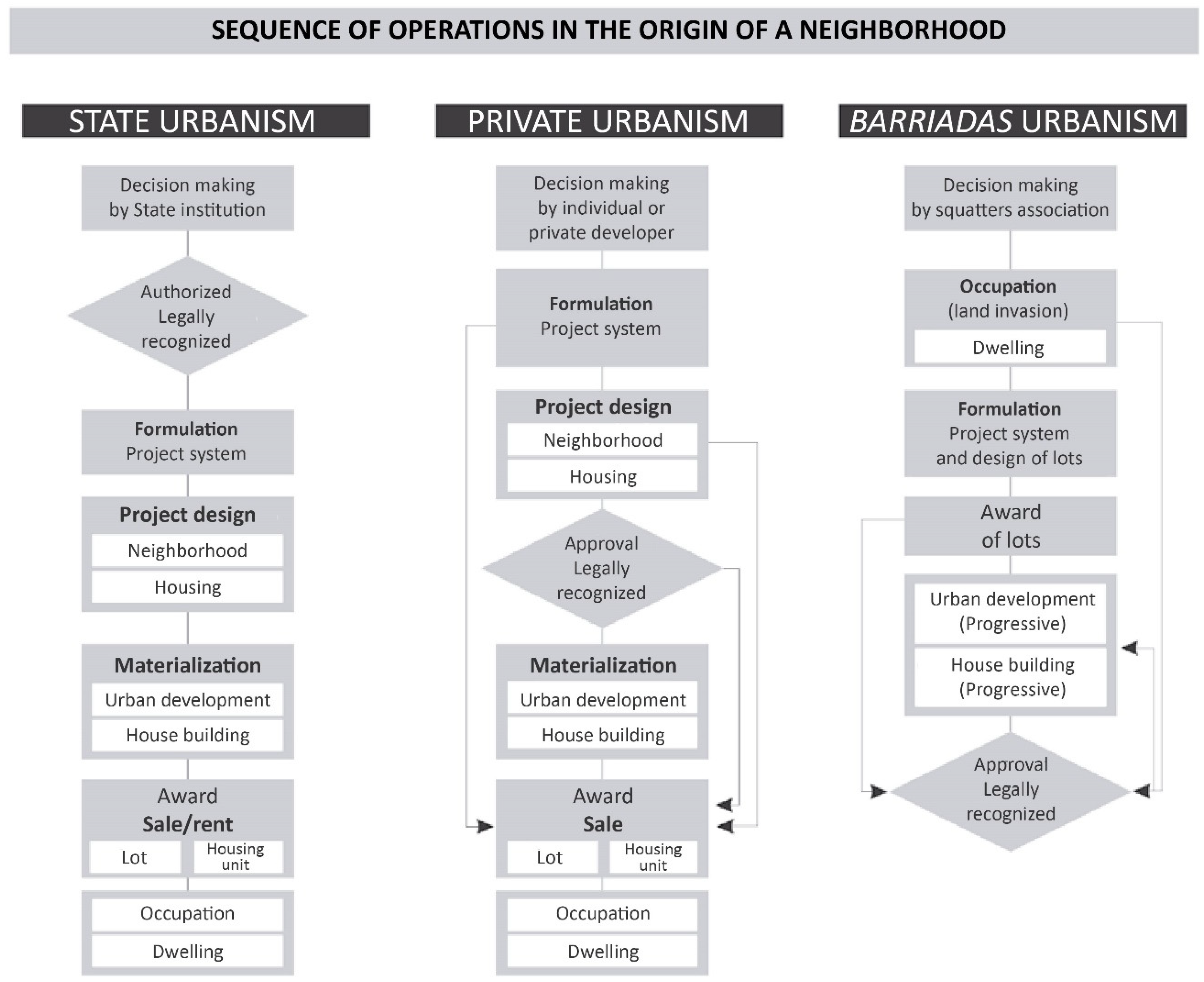
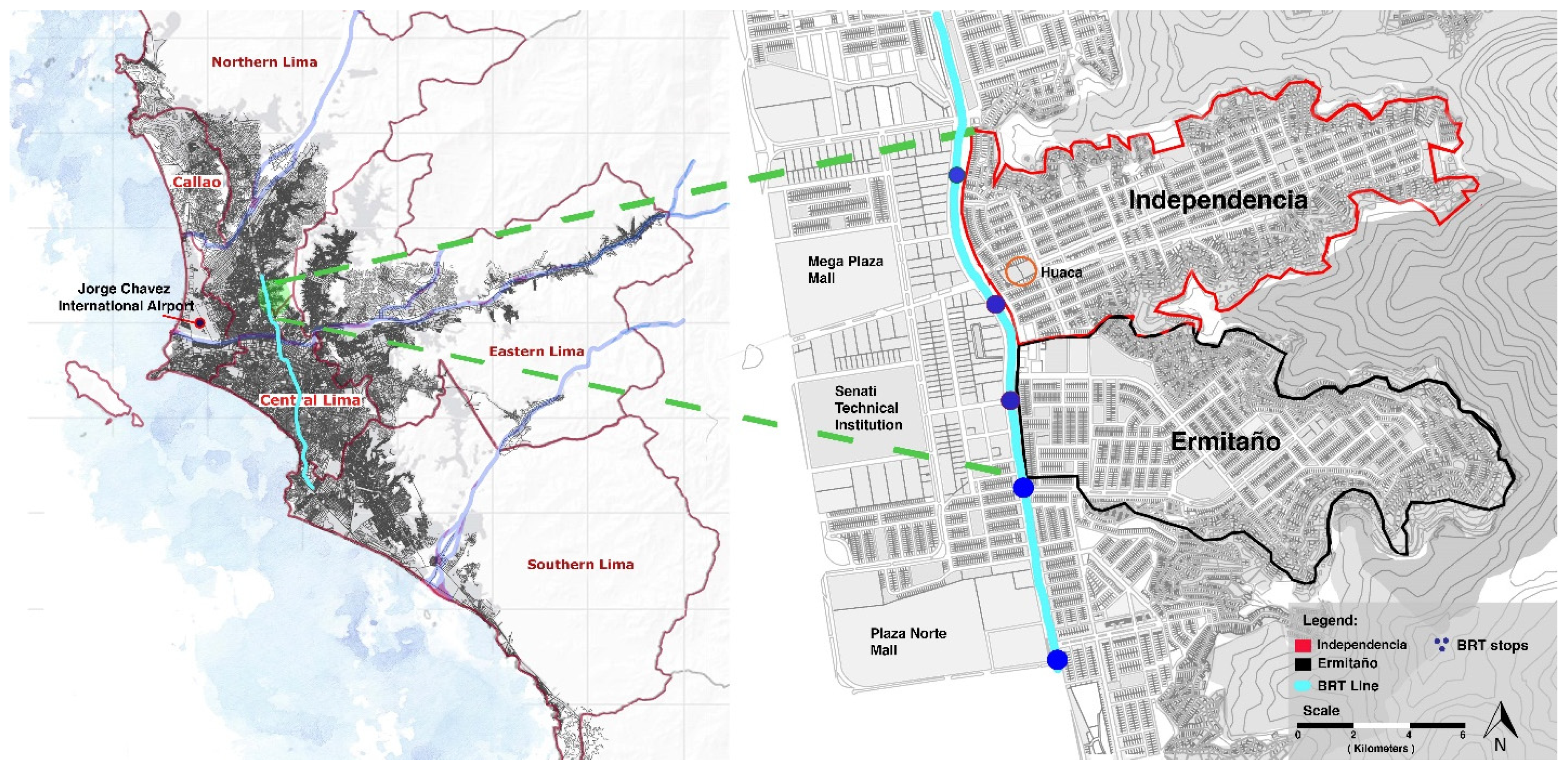
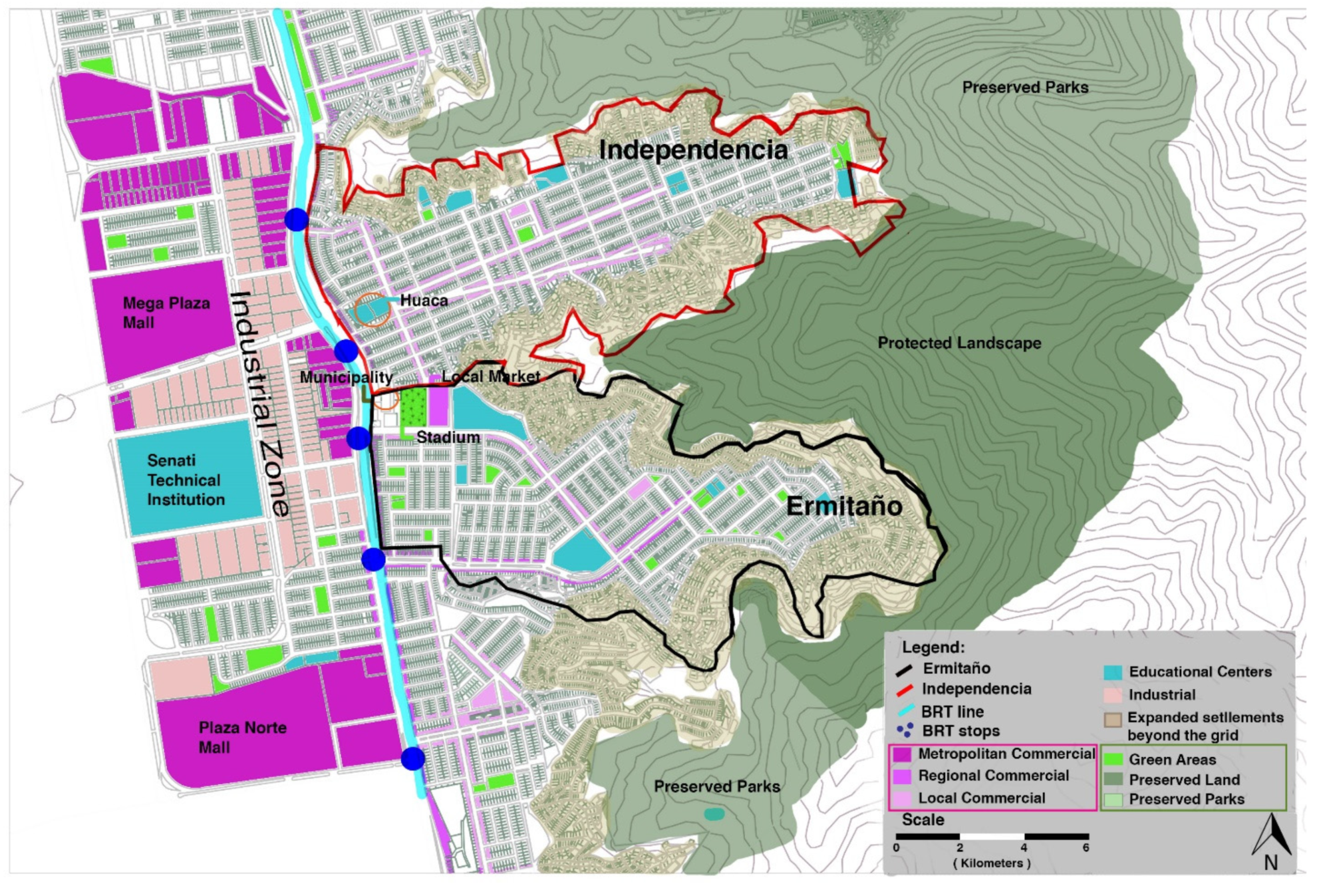
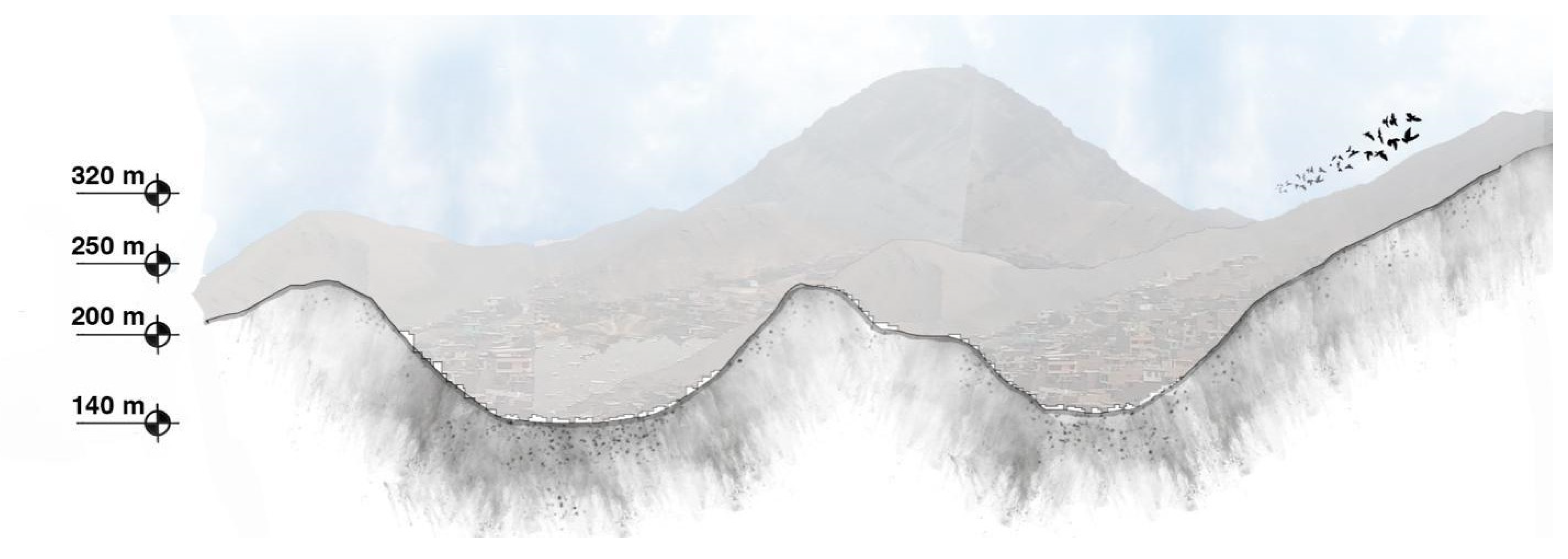
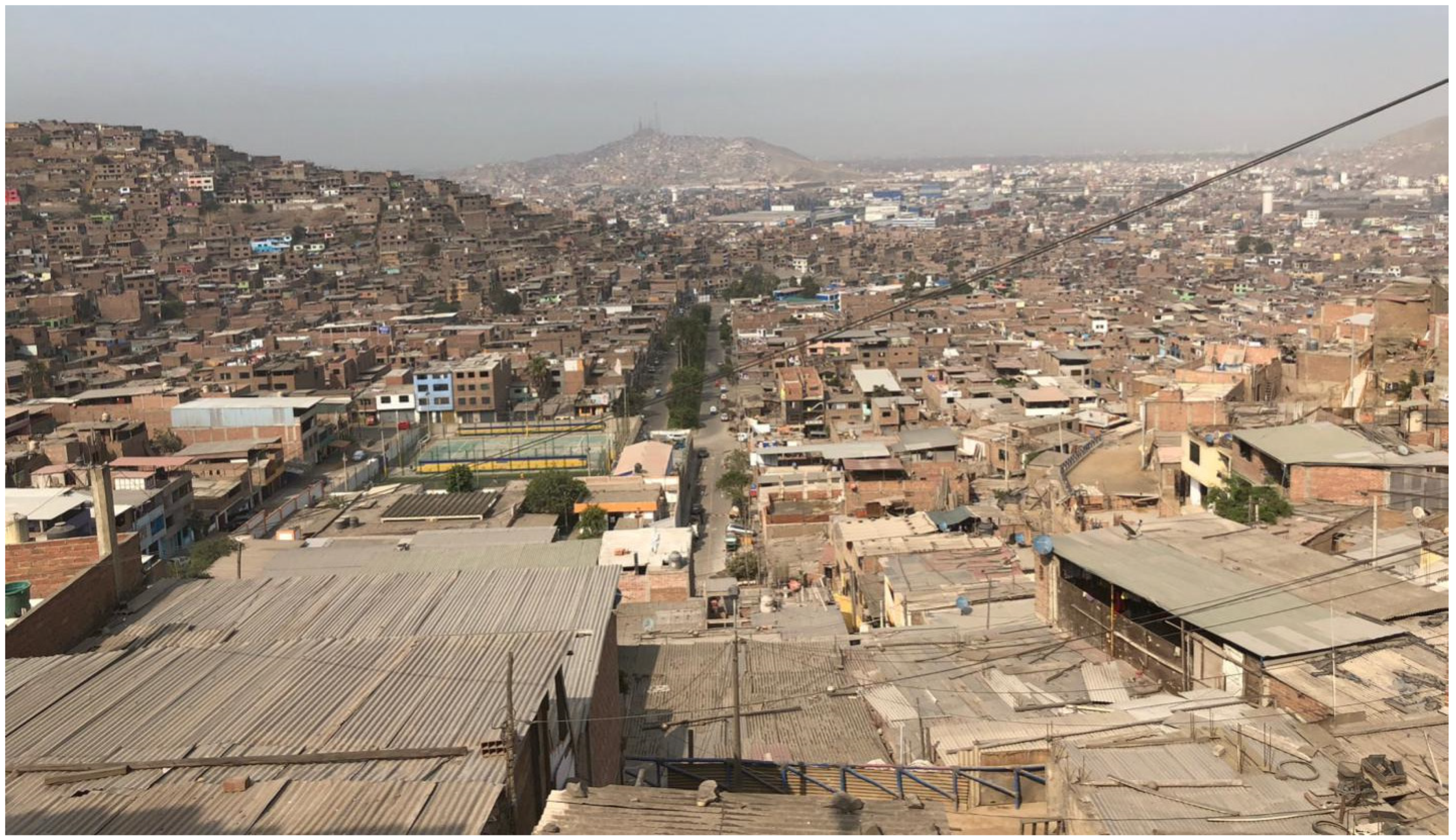
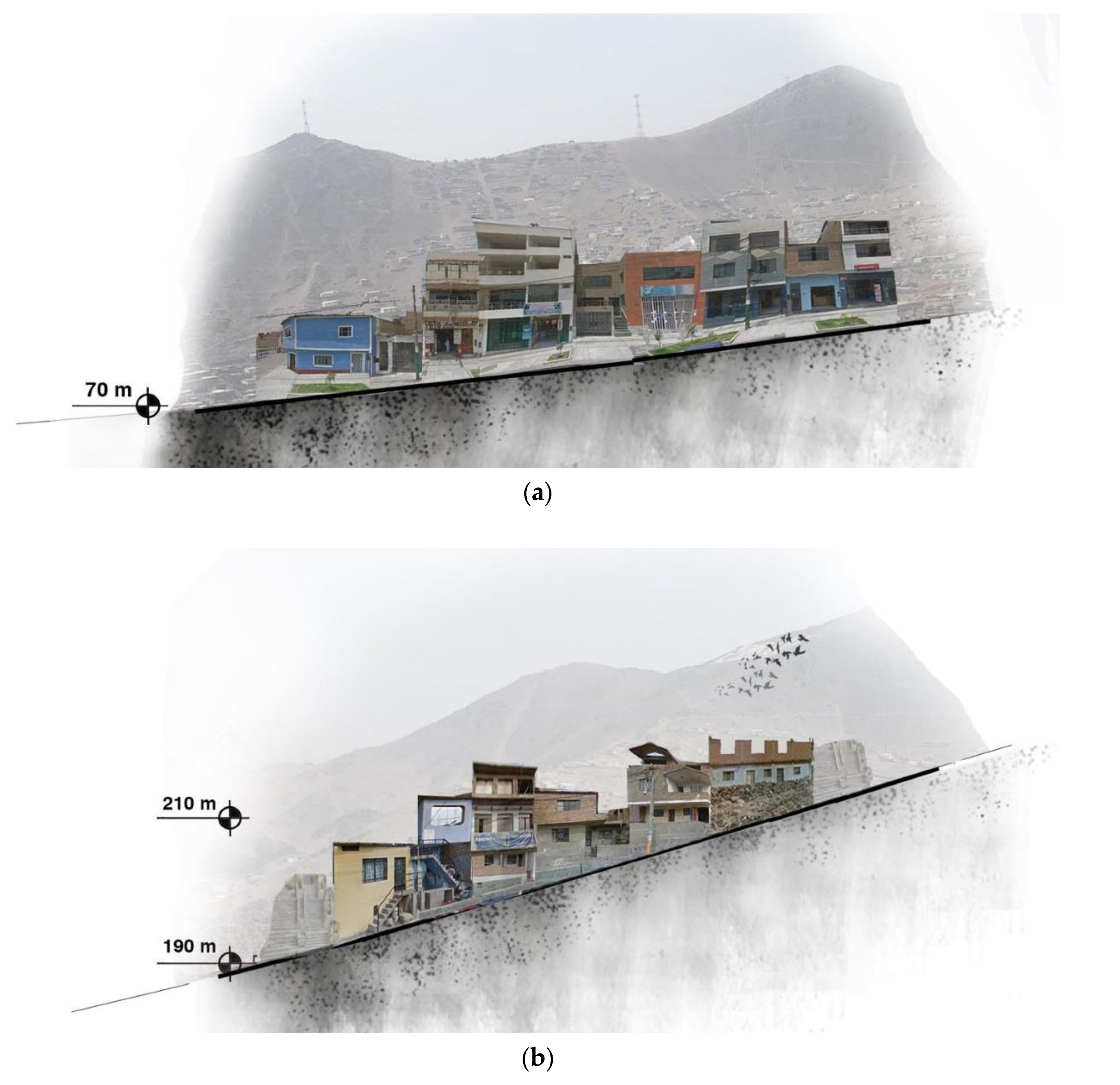
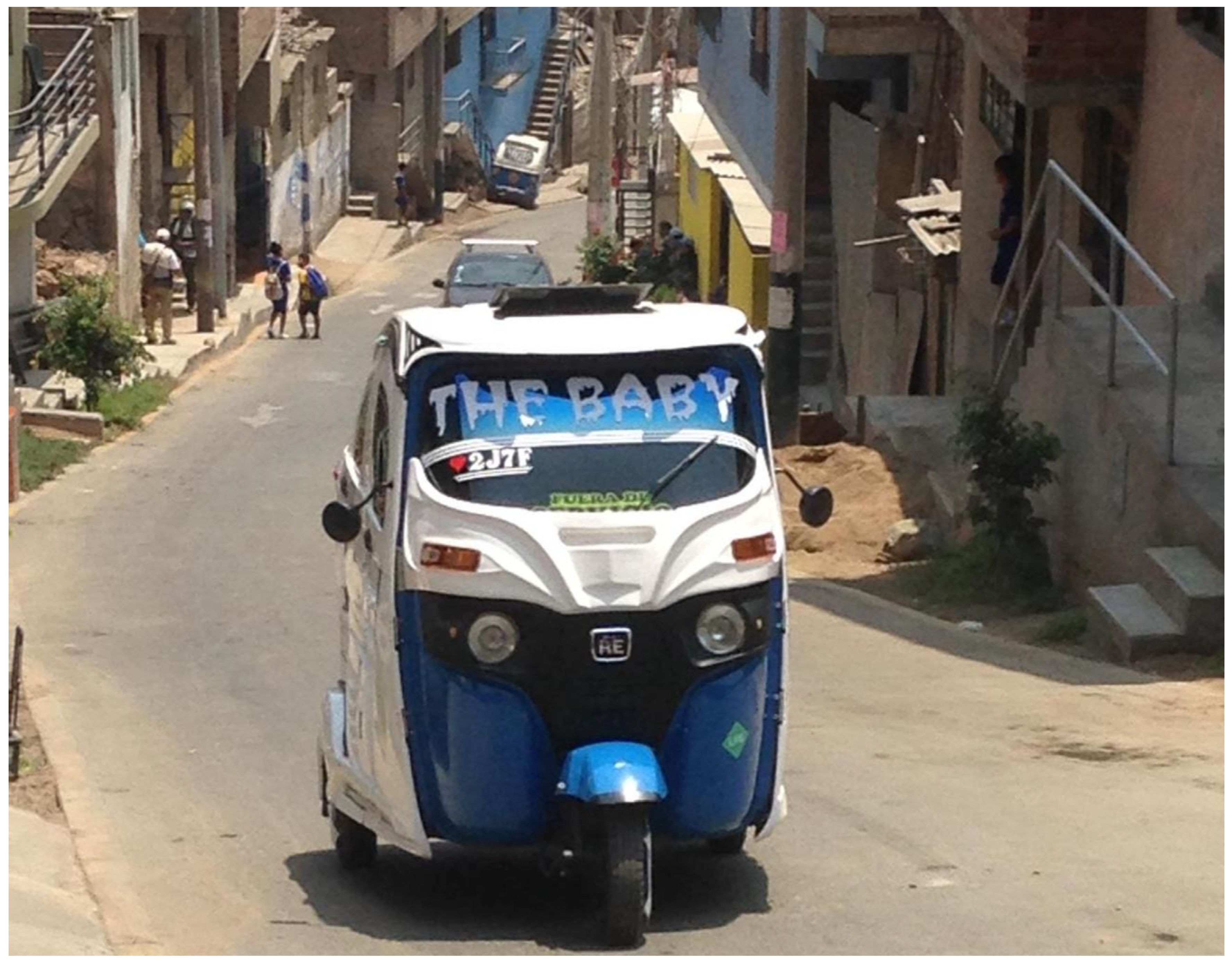
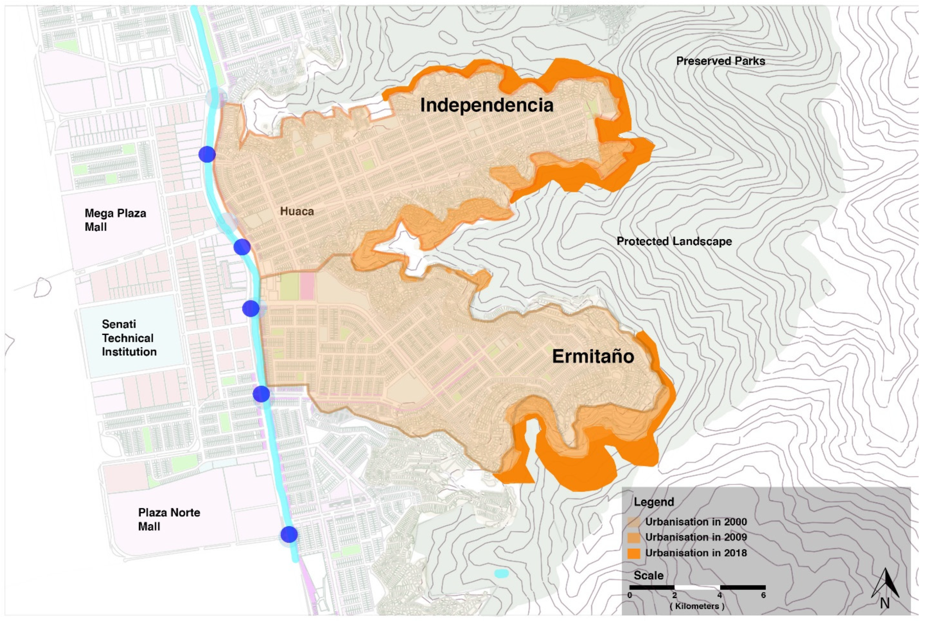
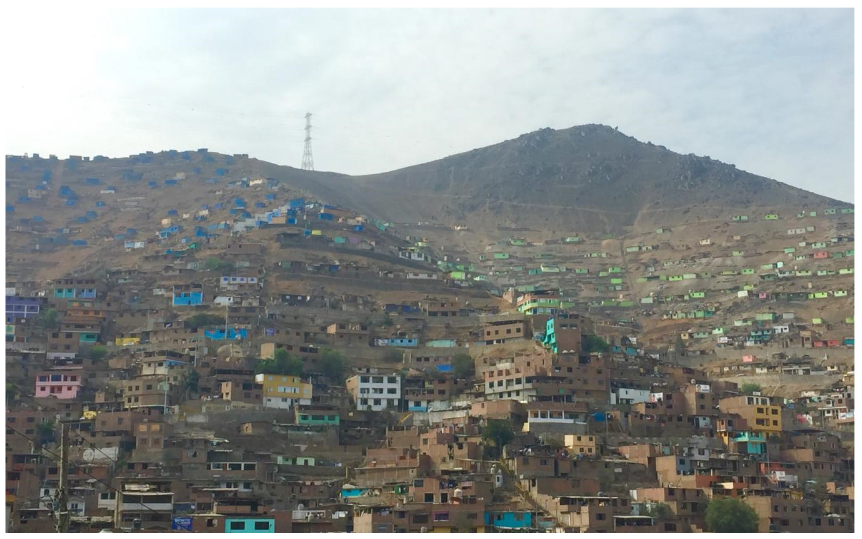
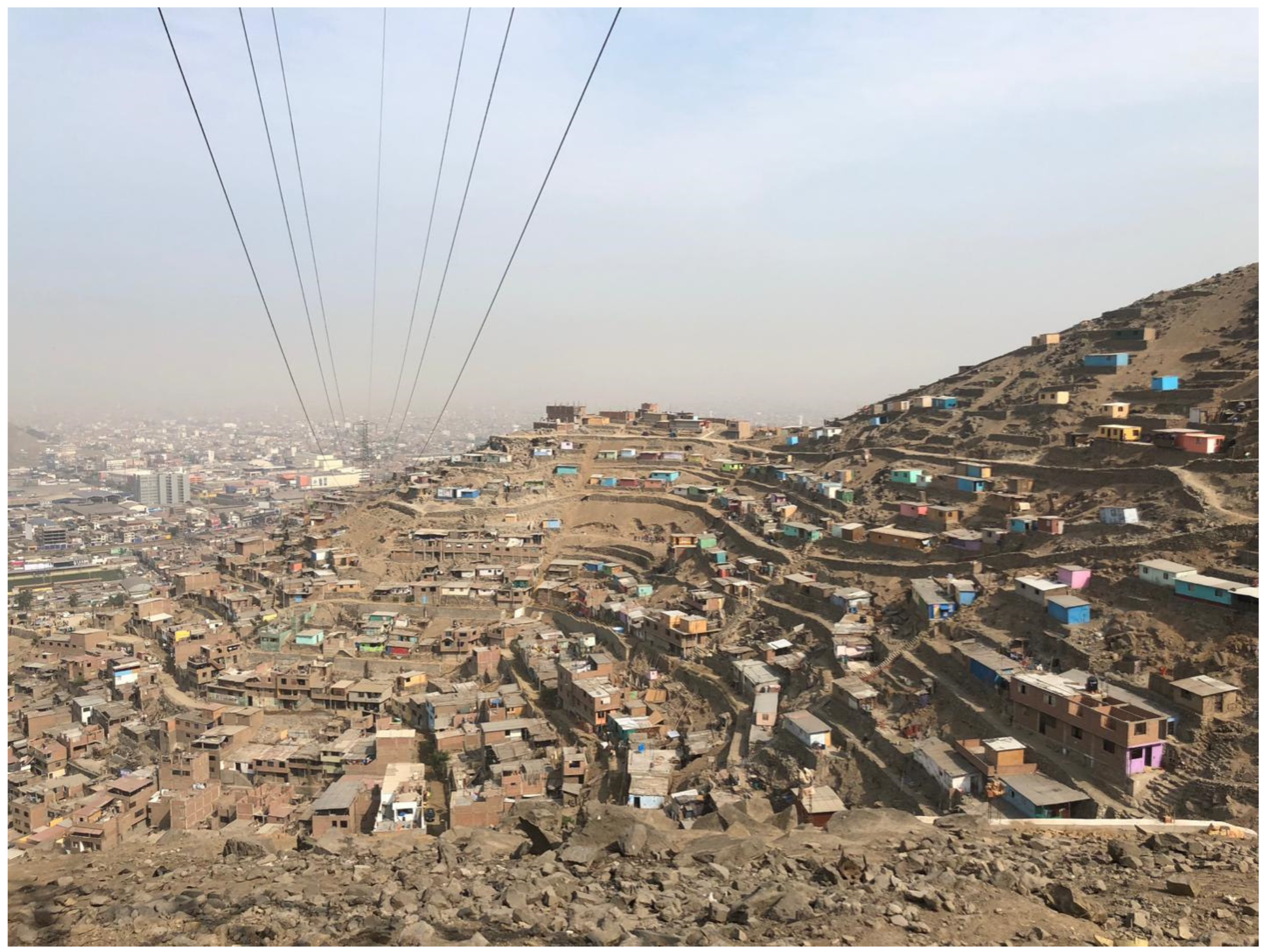
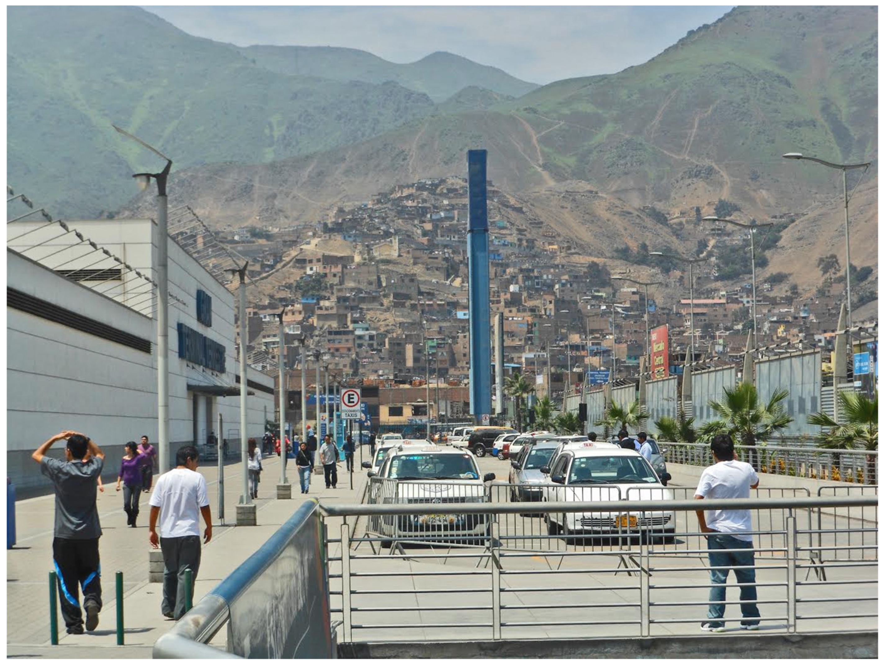
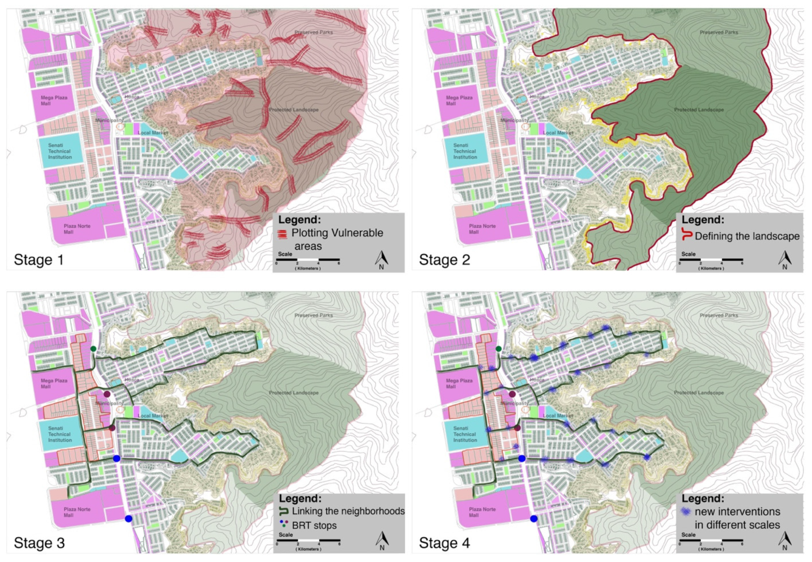
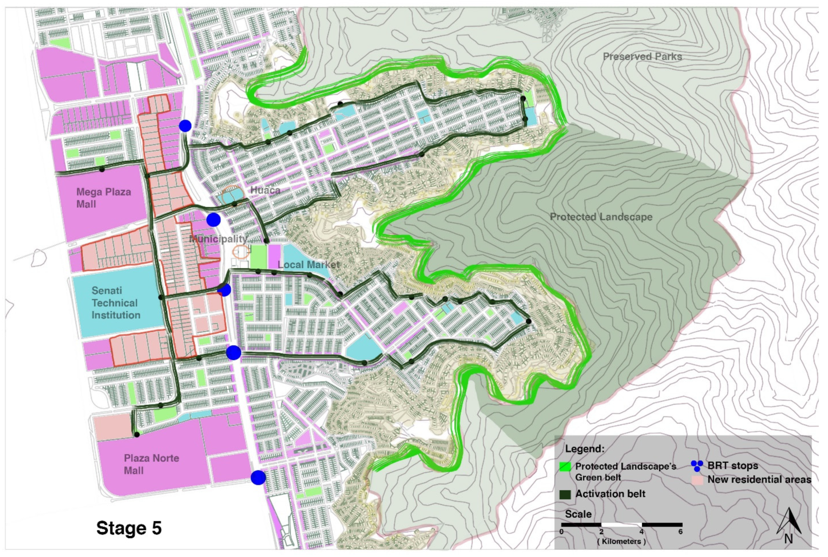


