Current Practice and Recommendations for Modelling Global Change Impacts on Water Resource in the Himalayas


1
Cranfield Water Science Institute, Cranfield University, Cranfield MK43 0AL, UK
2
National Institute of Hydrology Roorkee, Roorkee 247667, India
*
Author to whom correspondence should be addressed.
Water 2019, 11(6), 1303; https://0-doi-org.brum.beds.ac.uk/10.3390/w11061303
Submission received: 3 June 2019
/
Revised: 19 June 2019
/
Accepted: 21 June 2019
/
Published: 24 June 2019
(This article belongs to the Section Hydrology)
Abstract
:Global change is expected to have a strong impact in the Himalayan region. The climatic and orographic conditions result in unique modelling challenges and requirements. This paper critically appraises recent hydrological modelling applications in Himalayan river basins, focusing on their utility to analyse the impacts of future climate and socio-economic changes on water resource availability in the region. Results show that the latter are only represented by land use change. Distributed, process-based hydrological models coupled with temperature-index melt models are predominant. The choice of spatial discretisation is critical for model performance due to the strong influence of elevation on meteorological variables and snow/ice accumulation and melt. However, the sparsity and limited reliability of point weather data, and the biases and low resolution of gridded datasets, hinder the representation of the meteorological complexity. These data limitations often limit the selection of models and the quality of the outputs by forcing the exclusion of processes that are significant to the local hydrology. The absence of observations for water stores and fluxes other than river flows prevents multi-variable calibration and increases the risk of equifinality. The uncertainties arising from these limitations are amplified in climate change analyses and, thus, systematic assessment of uncertainty propagation is required. Based on these insights, transferable recommendations are made on directions for future data collection and model applications that may enhance realism within models and advance the ability of global change impact assessments to inform adaptation planning in this globally important region.
1. Introduction
The Himalayas are the source of many major rivers of South Asia [1,2]. They act both as orographic barriers, influencing monsoonal precipitation [3,4], and as natural water reservoirs that store the largest volumes of ice and snow outside of the polar regions [5,6]. Water resources generated in the region provide water supplies for almost 750 million people [2], for irrigated agriculture [7] and for hydropower [8,9]. The transboundary character of these large rivers makes them also relevant to the fragile political stability between co-riparian countries due to distrust and power asymmetry [10,11,12,13], especially as some discourses elevate water management to the national security level (i.e., securitisation of water; [13,14]).
High elevations, rugged terrain and interactions between orography and atmospheric circulation systems strongly influence the variation in temperature, rainfall/snow amounts, and hydrological processes over multiple spatial scales [15]. The barrier effect to south-north circulation causes windward precipitation accumulation and a leeward shadow effect. This combines with the negative temperature gradient with elevation to generate different climatic zones transversely to the Himalayas with a humid sub-tropical temperate climate in the south and cold arid climate in the north [16,17]. The relative importance of rainfall, snow- and ice-melt to the amount and seasonality of river flows also changes significantly along the Himalayas range influenced by the different dominance of climate features. Mean annual precipitation is quite uniform (1500 to 2000 mm/year west to east); however, monsoon summer rainfall is stronger in the eastern Himalayas (representing around 80% of the total annual precipitation) weakening towards the west, while the influence of winter Westerlies mostly affects high elevations of west and east Himalaya syntaxes causing larger snow accumulation [4,18]. As a result, meltwater plays a more important role in the hydrological regime in the western than central and eastern Himalayas [2], representing around 50% of total annual runoff vs. 20% and 35%, respectively [4]. The climatic variability along the Himalayas also results in two distinct types of glacier response [19]. In the east, maximum glacier ice accumulation and ablation takes place simultaneously during summer; in the west, accumulation occurs mostly in winter and ablation is limited to summer months [18,20].
Climate change is already tangible in the Himalayas [6]. Observations have shown temperature increases above the global average in much of the region in recent decades [21,22]. This effect is intensified with altitude, especially during winter in the western and central Himalayas [23,24] mostly due to snow-albedo and cloud-radiation feedbacks and is expected to continue in the future under all emission scenarios [25]. The Intergovernmental Panel on Climate Change (IPCC) Fifth Assessment Report regional projections indicate an expected increase in annual average surface temperature up to 3.1–6.0 °C for South Asia and 3.9–8.4 °C for the Tibetan Plateau by the end of the 21st century [26]. Historical and future trends in precipitation are more uncertain and variable across the Himalayas depending on the climate model, season and sub-region [27]. Generally, observations in western Himalayas suggest increasing annual precipitation over the last century, but not on the central and eastern Himalayas [21]. Future projections indicate an increase in annual and monsoon precipitation [21,27]. Long term projections point to increased annual precipitation over South Asia and the Tibetan Plateau with seasonal variations during the monsoon ranging from 1% and 4% up to 23% and 18%, respectively, with precipitation increasing by up to −1–21% and 4–28% in winter considering the uncertainty across Representative Concentration Pathway (RCP) scenarios and Coupled Model Intercomparison Project-5 (CMIP5) models (25 to 75 percentiles of the ensemble) [26].
Such changes in climate will impact future hydrology in Himalayan catchments, modifying flow extremes and seasonal discharge patterns due to changes in rainfall amounts and seasonality, as well as snow and glacier accumulation and melt [28]. Although changes in hydro-climatic extremes are still subject to considerable uncertainty and limited research has been conducted [21,29], a few regional studies predict increased flood risk caused by rising monsoon intensity—combined with possible snowfall reduction [20,30]—and accelerated glacier melt at least until the mid-21st century [21,31,32]. Floods caused by glacial lake outbursts (GLOF) are linked to glacier retreat and are, thereby, considered an increasing threat in the Himalayas [19,33,34] which is subject to considerable research in relation to the risk and mechanisms of occurrence, propagation and potential impacts [35].
At the same time, population growth and economic progress [36] will continue to drive land use; technological, behavioural and infrastructural changes; and increase water demand for, and competition between, people, food and energy production, and the environment [37]. The combined effect of these future socio-economic and climate changes, hereinafter called global change, may lead to reduced water security [38,39] resulting from imbalances between increased human water requirements and water resources availability, which is mostly dependent on average and low flows. Future severity, persistence and occurrence of low flows is highly uncertain with some studies pointing to increased frequency by the end of the century due to diminished snowmelt and glacier storage [21] while others report otherwise [31]. Thus, a robust spatio-temporal assessment of impacts on water resources generated in the Himalayas is necessary to improve water security through informed adaptation planning [40,41], which is of strategic importance for the regional economy and the livelihoods and well-being of downstream inhabitants [42,43].
Untangling the effects of climate and socio-economic components of global change is of paramount importance since the responsibilities over their drivers and mitigation, as well as the types of measures required to tackle them are deeply different [44]. In fact, many studies point to global change impacts being largely driven by socio-economic changes in many regions in the world [45,46,47]. Hydrological models are a vital tool to support this analysis as they translate the understanding of future climate and land use changes into impacts on river discharge, water availability and water demands in time and space. However, the climatic and orographic conditions of the Himalayan region pose important modelling and data challenges. The observational data to adequately characterise spatial variability of hydrological inputs and variables are scarce due to inaccessibility and high spatial variability [48,49]. Moreover, data quality can be an issue across the Himalayas [50,51,52,53] due to a lack of systematic raw data checks and discontinuous maintenance which result in data gaps, inhomogeneity of data and other data anomalies such as consistent biases [44]. Securitisation of water also hampers data accessibility as certain types of data such as river flows in some locations, glacier data, water management and consumption are restricted, generating (geo-political) uncertainty [14]. These issues lead to potentially high uncertainty in model outputs which is aggravated in studies of global change impacts where the inherent uncertainty in future changes in climate [54,55] and socio-economic (e.g., land use and water abstractions/diversions) [56,57] factors are amplified through a cascade of uncertainties [58,59]. For example, the selection of meteorological inputs for calibration conditions the model parameterisation and influences modelled climate change impacts [49,60,61]. Moreover, forcing models with conditions that are outside of the input ranges used in calibration increases uncertainty [62].
Previous reviews have addressed individual modelling aspects in mountainous areas that provide valuable insight for sound analyses of global change impacts on water resources in the Himalayas. Most of them compared the modelling approaches for snow and ice melt [63,64,65], sometimes focusing on the comparison of specific hydrological models [66,67,68] or in certain regions such as North-West China [68] or Central Europe [69]. Chen et al. [70] reviewed the status of hydrological modelling in glacierised catchments of central Asia to identify future challenges and directions focusing primarily on glacier melt modules, and Bales et al. [71] focused on the detailed modelling of energy fluxes in the mountains of western United States and the required improvements in data monitoring. Other studies looked into the impacts of climate change on hydrology in mountainous catchments and highlighted the adverse effects on snow and glaciers and on natural water regulation [72,73] as well as the need to make the results more meaningful and reliable for their use on water management [74]. Nepal and Shrestha [21] analysed the outcomes of modelling studies on climate change impacts in Himalayan catchments and identified varying impacts along the Himalayan range due to the combination of accelerated melt of snow and glaciers with increased precipitation; however, they did not assess the modelling approaches. To the best knowledge of the authors, there has not yet been any comprehensive review focused on Himalayan catchments which covers the whole hydrological modelling chain and discusses the influence of the modelling choices on the capacity to reliably simulate hydrological behaviour under global change conditions outside those of the calibration period. This paper focuses on the Indus, Ganges and Brahmaputra Himalayan river basins (see Figure 1) to: (i) review past water resource modelling studies in Himalayan river basins and to catalogue their modelling approaches, data sources, calibration, treatment of uncertainty and global change analyses performed; (ii) identify and discuss methodological, model and data limitations that constrain our ability to fully understand the hydrological impacts of future global change in the region; and (iii) make recommendations and identify research gaps for global change hydrological studies in the Himalayas.
2. Review Process
We reviewed hydrological modelling studies in the Himalayan region published in peer-reviewed journals between 2010 and 2017. The Scopus and Web of Science bibliographic databases were used to identify potential papers using a number of independent searches with combinations of the keywords ‘hydrolog* model*’, ‘catchment model*’, ‘runoff model*’, ‘Himalay*’, ‘Indus’, ‘Ganges’, ‘Brahmaputra’ and ‘climate change’ within the title, keywords or abstract. Relevant cited references within these papers were also examined. After screening for titles, abstracts and journals, a total of 68 studies were identified as relevant for further analysis.
For the selected studies, we documented the specific location, area and main physiographic features, as well as the final purpose for the use of hydrological models. Furthermore, we classified the studies according to the mathematical representation of hydrological processes and their spatial and temporal discretisation, following common classifications used in hydrology [76]. Finally, we catalogued the types of input data used, the calibration and validation techniques and variables, and the treatment of uncertainty. The information collected from each of the reviewed studies can be found in the supplementary material (see Table S1).
3. Overview of Reviewed Studies
The catchments studied are located throughout the Himalayan chain (Figure 2), with a higher density in the Indus and Ganges River basins than in the Brahmaputra. The Langtang (Ganges) and Beas (Indus) catchments are the most studied with eight and seven published studies, respectively. The range of catchment sizes is very wide (i.e., from 38 km2 to 1,005,786 km2), although the largest number of studies covers areas between 5000 km2 and 100,000 km2 (Figure 2).
Land cover types change from predominantly glaciers, grassland and bare soil in the higher elevations, to forest at medium elevations, and agricultural land in the lower parts [77,78,79,80]. However, the relative importance of each land cover varies from catchment to catchment. Studies in larger catchments report a wide variety of land cover, while for smaller (typically headwater) catchments, glaciers represent the largest land cover fraction [81,82,83,84,85] (Figure 2). The anthropic impacts are also different. From the few studies that report on them, the Indus river is generally the most affected by infrastructure such as dams [42,86,87], canals [88] and hydropower generation structures and diversions [80]. However, none of the studies model the influence of such infrastructures on the spatio-temporal availability of water resources across the catchment or at least do not report them. The reasons for this omission may be limitations of the selected hydrological models that do not represent their effects on river flows and data secrecy around water management and consumption that prevents incorporation of these components.
Many studies directly address climate change as their primary objective through the simulation of impacts on water resources [2,29,31,81,89,90,91,92]. In contrast, land use change as a component of global change and driver of future water availability and irrigation demand received minor attention [78,86]. The recognised limitations in modelling approaches and in the current understanding of hydrological processes in the Himalayas leads to a significant number of studies aiming at improving the simulation of current hydrological processes (i.e., model performance) [15,82,83,93,94,95,96] or focusing on understanding the relevance of each flow component in the hydrological regime (i.e., basin behaviour) [4,80,97,98,99] as a basis for future application to global change impact assessment. There are no clear spatial differences across the Himalayas in regard to the topics addressed, with perhaps the exception of climate change analyses in the Ganges, which are slightly more abundant among the reviewed literature. Table 1 shows the number of studies that address one or two of the abovementioned aspects as the main or secondary purpose (in rows and columns, respectively).
4. Processes Representation
4.1. Model Type
A wide range of hydrological model types have been applied in the studied catchments (see Table S1 in the supplementary material) that differ in process representation (process-based, conceptual and empirical), spatial resolution (distributed, semi-distributed and lumped) and temporal discretisation (sub-daily to monthly). The choices made on this regard are important for the ability to apply the model to changed environmental conditions and for the appropriate spatial and temporal representation of the current and future hydrological processes of interest. A detailed representation of the soil water balance is determining the estimation of changes in total runoff production through the interactions between future changes in temperature and precipitation. When modelling partially glacierised catchments, it is especially important to integrate snow and ice melt in the general hydrological models given that the significant contribution of meltwater to infiltration can occur under seasonal snowpacks [100,101] and glaciers [85], which is linked to other hydrological processes such as evapotranspiration and groundwater recharge. The conceptualization of the studied system to identify the most important processes is a critical point in the model construction and should inform the selection of the mathematical model. However, apart from stressing the importance of snow and glacier processes, other hydrological processes (e.g., infiltration vs. saturation excess overland flow, shallow vs. deep flow systems, front vs. block recharge mechanisms) or the level of water management impacts on river flows do not seem to guide model choices in the reviewed literature. Among the reviewed studies, process-based and conceptual models are the most commonly applied types (Figure 3), with SWAT (conceptual) [102], TOPKAPI (process-based) [103], and HBV (conceptual) [104] being recurrently used. The empirical models SRM [105] and SNOWMOD [106] are also used in a significant number of studies, especially in snowmelt-dominated catchments of the Indus and Ganges basins. Half of the process-based hydrological models identified are applied in catchments located in the Indus river basin and one-third in the Ganges.
Many studies apply process-based models with a gridded distribution (Figure 3). The sizes of the grid cells vary from 90 m [85,107,108] to around 50 km (i.e., 0.5 deg; [98]), with a median of 900 m for the 28 distributed models. There is significant correlation between catchment and grid sizes with some exceptions in which large catchments are modelled at very fine resolutions, i.e., 265,598 km2 at 107.52 m grid [109]. Some studies that use larger grid cells introduce sub-grid variability of land cover, glacier and hydrological processes [32,51,99]. The review revealed a significant number of applications of empirical models applied in a semi-distributed way using elevation bands [50,95,97,110,111]. Interestingly, many conceptual model applications combine the use of elevation bands with other spatial discretisation, mostly sub-basins [78,112,113,114] but also grids [115], thereby aiming to capture the influence of the extremely steep terrain together with the spatial variability of landscape features. The width of the elevation bands ranges greatly among studies, from 100 m [92] to 2000 m [116], mostly related with the size of the studied catchment and the complexity of the snow and glacier sub-models used.
Regardless of the detail in the representation of hydrological processes, the performance of a broad range of models in reproducing observed river discharges, volumes and seasonality in the reviewed studies appears good to high, based on the recommended ranges for Nash-Sutcliffe efficiency by Moriasi et al. [117]. This could suggest that the use of complex process-based models is unnecessary in the Himalayan region. For example, the conceptual HBV model [99,118] outperformed the process-based VIC model [119] when applied in a 1-km grid in the upper Beas catchment in the Western Himalayas; the empirical SRM and conceptual GR4J models [50] had similar levels of performance to the process-based model J2000 [52] when applied to the Dudh Koshi catchment in Nepal. However, good baseline model performance does not necessarily mean that a model will produce appropriate hydrological behaviour when applied outside of the historical hydro-meteorological conditions against which it has been calibrated [49,120]. In fact, a very dissimilar response to climate change is found in the Dudh Koshi catchment with increases in river discharge of 4.7 to 45.6% by SRM and 0.37 to 18.61% by GR4J models for the same range of scenario-neutral changes in precipitation and temperature [50]. In that regard, parsimonious models have limitations to representing the catchment response beyond calibration and validation conditions [121]. Models whose parameters hold stronger physical meaning (i.e., process-based and complex conceptual models) are believed to have better predictive capabilities as their parameters can be more reliably considered constant under divergent forcing conditions [122], such as climate change, although they are more prone to equifinality problems.
4.2. Snow and Ice Hydrology
The temporal and spatial behaviour of snow and ice are controlled by many factors, with air temperature, solar radiation, surface albedo, wind velocity, humidity, and heat transfer from incident precipitation controlling the melting and refreezing of the snow and ice packs [65,66]. These processes along with infiltration of meltwater determine the magnitude and timing of meltwater contribution to stream flows. The reviewed studies demonstrate that these processes are defining factors for the hydrology in Himalayan catchments. However, the level of detail in their representation in models is not consistent across literature.
Possibly due to the fact that air temperature data are available and persistent across large areas [65], the most common approach to representing snow and ice melt in the reviewed literature are simple temperature-index models (Figure 3) that describe meltwater production as a linear function of air temperature at a rate defined by a constant-degree day factor that translates temperatures above a melting threshold to the melt snow water equivalent [42,48,87,88,91,99,114,119,123]. Detailed energy balance models are the least common [79,94,107,115,124,125,126] despite their more detailed process representation, most likely due to their much greater data requirements. Accounting for solar radiation is relevant in high elevation mountains in low latitudes since it can trigger melting even if temperatures are below the freezing threshold [4,125], contributing a significant fraction of total runoff in winter. It can have a strong impact on the spatial variability of melt processes in rough terrains in which topography (aspect, shading and slope) conditions the exposure of snow and ice sheets to solar radiation [84,118]. Similarly, the common debris layers over Himalayan glaciers have been demonstrated to significantly affect their melting properties [52,124]; their effect can be represented by specific albedo values. These advances in understanding show the importance of solar radiation in snow/ice melt processes and suggest that distributed energy balance models should be used in preference to simpler temperature-index models to estimate melt contributions to runoff [98]. However, the fine spatial resolution of solar radiation data needed to represent these processes [127] can be compromised by the sparse data available at high elevations in the Himalayas. This situation has triggered the adaptation of the temperature-index models to incorporate other relevant processes for the snow/ice pack energy budget and make them less reliant solely on temperature. Enhanced temperature-index models add the radiation term to the melting equation and consider the snow/ice albedo. They can offer a good compromise by having the advantage of being sensitive to the effect of topography on solar radiation while having fewer parameters requiring calibration. They can also easily represent snow ageing by taking variable albedo values as a function of time [124] or temperature [82,98,115,118,128] with different decay functions. These and energy balance models can directly consider the influence of debris on glaciers by reducing ice albedo [83,94,107] and even the effect of thick debris layers on delayed melting [82,108]. Dust cover on snow also increases albedo [129] and thereby accelerates snowmelt processes as reported in some of the reviewed studies [82,130]. Whilst the recent evolution of debris and dust cover can be mapped using remote-sensing products (despite difficulties due to confusion with bare ground), spatial distribution of thickness and future changes in covered areas due to rock falls, weathering from steep surrounding slopes and wind transport are much more challenging to consider [82], and are sometimes simplified to presence/absence segregation based on slope thresholds in valley glaciers of the Himalayas [52]. Studies that use simple temperature-index models try to introduce debris effects by using a specific empirical degree-day factor for debris-covered areas [79,92,108,131]. Moreover, several studies introduce variations into the temperature index-based model that accounts for the melting induced by rain falling on snow or ice [95,110,132], aspect corrections to degree-day factors [85,108], and seasonal degree-day factors [78,92,132,133,134] which indirectly represent the variation in melt characteristics between dry highly reflective fresh snow and wet lower reflective seasonally-aged snow.
A crucial aspect to ensure a correct balance between the diverse hydrological flow components is accounting for the evolution of snowpack and glacier volumes as they determine the available water that can potentially contribute to runoff. Snow accumulation also influences glacial ablation since it shields glaciers from solar radiation and prevents ice melting [135]. Unsurprisingly, snowmelt is considered in almost all of the reviewed studies but the snowpack itself is not modelled in 27% of them. In these studies, the variation in the snow-covered area over time, i.e., snow depletion curve, is an input to the model. Snow depletion curves are derived from satellite data products and, thereby, avoid modelling the evolution of the snowpack [48,95,136]. This approach is frequently applied to feed temperature-index models and their enhanced version in the empirical SRM and SNOWMOD [137] hydrological models [4,48,60,95,97,110,132,133,136,138], but it has also been used with the conceptual model HBV [80] and the process-based model HEC-HMS [88]. While this approach compensates for data scarcity in remote areas, it results in snowmelt being unconstrained by the depth of snow. When applied in climate change studies, future snow depletion curves are projected based on temperature [50,89,139,140,141], but disregard the influence of precipitation–temperature relationships on snowpack formation which has obvious limitations to represent snowmelt water availability under future climate change conditions [120]. The contribution of ice melt from glaciers to total runoff was accounted for in 59% of the applications but less than 18% modelled the mass balance of glaciers [2,51,79,85,92,94,115,130,142,143]. The remaining studies represent glaciers through a fixed ice mask derived from remote-sensing products, effectively considering them as infinite sources of melt water [61]. Two studies covering relatively small-sized catchments below 3000 m above the sea level [90,144] do not consider snow nor ice in any way. There seems to be no relationship between the melt model type and the snow/ice variables considered, but notably all energy balance models consider at least the snowpack evolution.
There are other processes that affect the snow/ice mass balance that, whilst relevant to the long term stability of local hydrology, are more difficult to introduce into models due to the lack of data and the limited underpinning knowledge. Meltwater refreezing is an important process to represent the water-holding capacity of the snow and ice packs, as part of their storage effect [145]. It can be incorporated into energy balance models by considering the changes in internal energy in the snowpack or the glacier [94,125], but requires simplification in temperature-index models and their enhanced version through a refreezing coefficient [29,31,32,82]. Avalanches result from large snow accumulations on steep terrain and are important for glacier nourishment and the redistribution of snow cover to lower elevations [52,85]. They are empirically modelled in few reviewed studies through the introduction of a maximum snow water equivalent and a slope threshold [15,81,82,84,85,92,93,128,146]. Similarly, glacier dynamics, understood as the movement of ice sheets from higher elevations (mass gain) to lower elevations (ablation), plays a key role in the mass balance of glaciers and defines their resulting shrinkage/advancing behaviour. However, the very few studies that model it assume that basal sliding is the main movement process which occurs when a certain equilibrium shear stress is exceeded, but exclude internal creep or deformation (Weertman’s equation; [147]) to calculate the daily glacier speed [85,108]; or assume that basal shear stress is constant and use Oerlemans ice velocity equation [148] to route ice flow once every year whilst calibrating basal sliding and internal deformation parameters [84,92]. Other processes such as compaction that define the relationship between snow depth and water equivalent [128], and sublimation [115] are very rarely considered as they are poorly understood and model outputs are difficult to evaluate. The majority of these detailed snow and ice processes are aggregated in a temperature index or enhanced-temperature index melt models combined with process-based hydrological models with gridded spatial distribution.
In parallel to hydrological processes modelling, if the application purpose is analysing climate change impacts, snow/ice models should have predictive capabilities and be sensitive to changing future conditions, which supports the use of energy balance, or at least enhanced temperature-index models, and incorporate the relevant processes for snow/ice mass balance ensuring that calibrated parameters are suitable for the projection of climate change impacts. This is especially important in the western Himalayas and the Karakoram where a larger meltwater contribution is identified. Studies report annual average fractions of total runoff of 16–75% for snowmelt and 10–48% for ice melt in the Indus basin, 3–85% for snowmelt and 14–62% for ice melt in the Ganges basin, and 10–41% for snowmelt and 3–25% for ice melt in the Brahmaputra basin. The range of values is mainly due to the variety of sizes and elevations of the studied catchments with higher relative meltwater contributions associated to small high elevation catchments, while reduced meltwater fractions are found in larger catchments having a greater proportion of low elevation areas where monsoon runoff has more relative importance [98]. Therefore, the level of accuracy required to model snow and glacier processes should be informed by the size and elevation of the catchment. Notably, 50% of the studies which apply process-based melt models (i.e., energy balance models) are located in the Indus river basin.
In addition to general snow melt-accumulation processes, reproducing variations in the snow elevation line and glacier extent, which have already been observed in some areas [28,149,150], is of concern with regard to global change studies. In such cases, the quality of meteorological data can be a limiting factor in complex topography regions as errors in meteorological variables at high elevations lead to erroneous snow and ice storages that will potentially lead to errors in simulated melt runoff [118,151]. Hegdahl et al. [118] compared the temperatura index, enhanced-temperature index and energy balance methods coupled with a conceptual hydrological model at 1-km resolution concluding that model performance was more sensitive to the precipitation input, i.e., interpolation method, than to the melt model complexity. Therefore, adequate representation of meteorological variables at local scale should be considered a priority in future studies in the Himalayas. Models with spatial setups capable of properly capturing the evolution of the ablation-melt equilibrium are also required. Siderius et al. [98] simulated snow accumulation and melt with both land surface LPJmL [152] and JULES [153], and hydrological models SWAT and VIC [154] of differing spatial and temporal resolutions and snow/ice melt modules (temperature index vs. energy balance), and concluded that the representation of elevation had a greater effect on the amount and timing of snow accumulation and melt than the model formulation, with elevation bands better able to capture the vertical heterogeneity of the terrain and the meteorological variables than grids. Whilst elevation bands capture vertical variations, they fail to represent horizontal changes that affect other hydrological processes suggesting that the combination of grids (or sub-basins) with elevation bands may offer improved spatial representation.
As mentioned before, the daily time step is generally used across the reviewed studies. However, intra-day variations can lead to snow melt and refreezing that cannot be captured by models that use time steps equal or longer than the day. In those cases, the use of daily active temperature (i.e., accumulated hourly positive temperature) instead of daily average temperature seems to improve modelling outputs [155].
5. Model Setup
As important as the selection of the model type are the decisions made at the different stages of the model construction which can affect model performance and behaviour [49,120]. These include decisions regarding the meteorological and landscape data used and the range and quality of measurements for calibration of the output variables of the model. The inaccuracies introduced in the results due to each of the involved elements (i.e., model, data and parameter) and their interaction should also be assessed to delimit the applicability and reliability of the results.
5.1. Input Data
5.1.1. Meteorological Data
In Himalayan catchments, all meteorological variables are affected by the high elevations and the irregular extreme topography. The challenge of this spatio-temporal complexity for hydrological modelling is compounded by the inevitably limited coverage of rain gauge and weather station networks which are unable to well-characterise the steep temperature and precipitation gradients [70,151,156], leading to significant uncertainty in precipitation, evapotranspiration and melting. Thus, when point data from meteorological stations are used (which are often located at relatively low elevations), spatial prediction is necessary to provide an adequate representation of the variables across the catchment. More than half of the studies (63%) use point observational data only, especially in the Indus and Ganges basins (Figure 4a). Simple methods such as the inverse distance [52,79,131,142,143] and Thiessen polygons [84,90,112,157], combined with lapse rates for temperature and precipitation taken from literature or derived from the existing point data, are the most frequently used to estimate values at unmeasured locations. Kriging [118] and angular distance weight [94] methods have also been applied. Many studies introduce seasonal variability to the temperature lapse rates [15,48,52,80,81,138,141] and to the vertical [141] and 3-D [15,81,82] precipitation gradients. Where temporal interpolation was considered necessary, spline interpolation has been used [115,142].
To compensate for sparse observational networks, some studies have either used a combination of point and gridded data for different variables (Figure 4a), time periods and sub-basins [88,94,95,118,141], or used gridded meteorological data of varying spatial resolution (i.e., from 5 km to 2.5 deg). In spite of the significant advance that gridded meteorological data products bring to the modelling of catchments with sparse meteorological stations, their spatial resolution is often still coarse or has shown deficiencies that limit their usefulness for hydrological modelling in steep terrain regions [118,151]. Furthermore, the lack of surface observations necessary to validate and bias-correct these products undermines the intended improvements in the modelling capabilities and restricts the quality and detail of results. Precipitation is particularly complex to characterise in the Himalayas due to its high horizontal and vertical variability, and the fact that it can fall as rain or snow depending on the season. Not all observational stations are equipped to measure snowfall, thereby winter precipitation above the seasonal snowline is frequently underestimated [126]. The most commonly used gridded precipitation datasets to replace surface rain gauged data in the Himalayas are the remotely-sensed product Tropical Rainfall Measuring Mission (TRMM) [49,88,141] and the algorithm-based interpolated product Asian Precipitation-Highly Resolved Observational Data Integration Towards Evaluation of Water Resources (APHRODITE) [60,95,114,142]. When compared with point data, APHRODITE shows poor reliability at high elevations [60,94,95,126], as does TRMM [80,126,134] despite some of its products having higher resolution. Contrasting one data source against the other in the Beas river basin, Remesan and Holman [49] found that the differences in time and space between them were significant and increased with elevation. Nevertheless, they provided very similar model performance after calibration, with TRMM yielding slightly higher values for Nash-Sutcliffe efficiency than APHRODITE. This clearly highlights the role that calibration can play in compensating errors in the input data. Two studies that compared the use of point observations and gridded data products for precipitation, HBV using TRMM [80] and SRM using APHRODITE [60], found that hydrological models which used relatively dense precipitation ground data outperformed those using gridded products. This may be due to the capacity of station observations to better capture short lifetime events such as convective monsoonal rainstorms that occur at a valley scale [15]. However, this is only possible in small well monitored catchments as, in general, the number of stations available is not significantly correlated with the catchment size (Figure 4b). The recognised limitations of TRMM and APHRODITE in the Himalayas has led to some studies modifying or adjusting them to improve their performance [53]. Wulf et al. [80] corrected TRMM using snow cover, air temperature data and precipitation ground data, and Lutz et al. [29] corrected APHRODITE using the glacier mass balance of major glacier systems as per Immerzeel et al. [151].
In relation to temperature, Panday et al. [60] compared simulated discharge results for different data sources (point data with static lapse rates, point data with seasonal lapse rates and MODIS data) and concluded that point data with seasonal lapse rate produces better results for small catchments (<1000 km2) but that MODIS is the best data source for catchments larger than 10,000 km2. This suggests that efforts should be directed to increase both the density of weather observation stations [146] and their integration with remote-sensing and re-analyses datasets to generate more accurate distributed data. Other gridded products found in the reviewed studies for precipitation and other meteorological variables include data re-analyses products (e.g., ERA, MERRA, GLDAS and CFSR) [107,118] and regional climate models [77,115,126,158] (see Table S2 in the supplementary material for the full list).
From the review process, it is possible to identify the distinct status of research across the Himalayas. Despite the fact that the density of meteorological stations is similar across the region, studies in the Brahmaputra tend to use gridded data in contrast to the Indus and Ganges. This could be related to the reliability of the data, its accessibility and/or maintenance. Ad hoc sampling campaigns are only reported by studies located in the Upper Ganges [15,81,82,84,133] and Indus rivers [92,95,159]. Altogether, this may explain the larger number of studies applying process-based hydrological models and energy balance melt models in the Indus and Ganges than in the Brahmaputra River.
5.1.2. Landscape Data
Many spatial characteristics of a catchment or river basin influence the hydrological behaviour, including soil types, land uses/land cover, hydrogeology and topography. As with meteorological data, the resolution of such data should ideally be at least equal to the spatial discretisation of the model. However, spatial and attribute soil data are commonly only available in low resolution global datasets such as the Harmonized World Soil database [49,98,125], the SOTER database [52,79,114,160], and the FAO/UNESCO Soil Map of the World [78,98]. Moreover, most of the available datasets do not provide the hydrological parameters of the soil, which forces the modellers to use literature values or to calibrate them without local references. Hence, it would be highly beneficial for national and higher resolution information (e.g., National Bureau of Soil Survey and Land Use Planning-India for soil data) to be made publicly available.
Similarly, the land use/land cover inputs generally used are global products derived from satellites such as Landsat [94,113,161], MODIS [107] and IRS-P6 [110,118] that, despite their acceptable spatial resolution, are only available for recent years. Furthermore, the differential illumination caused by the rugged relief can cause imperfect land cover classifications; in fact, some studies explicitly describe the topographic corrections made to obtain a normalised reflectance [78,139]. Specifically for snow cover, MODIS satellite products are the most used [89,94,97,141], sometimes combined with finer resolution Landsat products of fractional snow cover [80,95,128,138]. Landsat products (7, 8, EMT+) are also frequently used to determine glacier extent [94,107,108] including debris coverage [81,84,95]. Glacier inventories like the Randolph Glacier Inventory [80,118,124,142,143], the China Glacier Inventory [115] and the ICIMOD Glacier Inventory [134,162] are also used to define glacier areas, but only provide a static image of the glacier extent.
5.2. Calibration
In the absence of field measurements to parameterise process-based models, and for conceptual and empirical models whose parameters do not have full physical meaning, it is necessary to tune selected input values through a calibration process. This can be done manually as a trial-and-error exercise [113,126,160,162,163] or using optimisation algorithms such as SCEUA [94,118], Rosenbrock [48], Markov Chain Monte Carlo data assimilation approach [60,79] or ensemble Kalman filter [128]. The objective function for calibration can be compounded with different performance criteria which drive the calibration differently [117,164]. Among the reviewed papers, forty-four use the Nash-Sutcliffe coefficient [83,118,126,159], which many combine with the percent or volume bias error [49,143,163]. Twenty-three studies consider three or more performance indicators [29,52,88,93,114,157,160]. However, none of the studies use specific performance criteria for peak and low flows which would make them more robust under global change conditions in which more frequent extreme flows are expected [29,31].
Given the aggregate consequences of the spatio-temporal complexity of hydrological processes within Himalayan river basins, the uncertainty in modelling inputs, the widespread application of distributed or semi-distributed conceptual and process-based models, and the intent within climate change impact assessment to go outside the observed hydro-meteorological conditions, it is important to have confidence that a given model is producing acceptable simulated outputs for hydrologically acceptable reasons within all aspects of the water budget (e.g., evapotranspiration, surface runoff, groundwater, snow and ice melt). Judging model outputs based on expert knowledge can help to ensure that the model appropriately reproduces hydrological signatures [165] of the historical period and provides a good basis for future hydrological projections. If the calibration process is insufficiently constrained by observations, many combinations of parameters values are able to represent the observed hydrological behaviour of the basin with similar goodness of fit [61,77]. The equifinality of parameter sets [166] constitutes a source of uncertainty by itself and threatens the predictive capacity of the models for global change studies. For example, Remesan and Holman [49] and Remesan et al. [120] demonstrated how the compensation effect of hydrological model parameterization for input data and modelling assumptions uncertainty is ‘hidden’ during calibration, but subsequently affects the magnitude of future simulated climate change impacts when moving outside of the observed range of conditions. To constrain the calibration and avoid compensation of errors, limiting parameters ranges in line with similar studies [166] or based on expert knowledge [44,167] is good practice. Spatial multivariable calibration is, however, the most recommended approach to address equifinality by using gauged river discharges at several points, along with actual evapotranspiration or snow cover. However, over 67% of the studies only evaluate the performance of the model against river discharge without considering any other hydrological variables. Other studies have combined discharge with snow cover [93,128,134,163], glacier volume [51,95,158] or base flow [110,136]. Eight models have calibrated against three or more variables including glacier mass balance [29,31,83] and movement [84,85], groundwater levels [113], or actual evapotranspiration [81,82].
Only three studies in the Ganges [15,81,82] and three in the Indus [84,92,159] collected part of their data from field campaigns to define parameter values (e.g., snow albedo, debris thickness and snow density) or for calibration (e.g., ice melt and velocity). The fact that field campaigns are rare amongst the reviewed literature and that they cover very small, high elevation areas emphasises the difficulties of data acquisition in the area, physically and due to geo-political sensitivities. However, a limited number of field campaigns could provide very useful data regarding snow/ice data and seasonal parameters if they were strategically designed. For instance, focused sampling campaigns above and below the equilibrium line altitude [82] or in locations identified as having higher uncertainty with the use of models [146] are efficient strategies that have proved to be very beneficial for the modelling outcomes. In the absence of direct measurements, most of these studies derive observed data from remote sensing products. For example, the spatial extent of snow and glaciers provided by optical and radar instruments is useful to check the agreement between simulated and observed presence/absence of snow and ice; radar observations are also useful to determine glacier velocity fields that can be applied to estimate ice thickness [168]. Nonetheless, information on snow depth is needed in order to check that the balance of snow accumulation and melt is correctly represented in the model [128]. For this purpose, further research to assess the potential of products such as dry/wet snow maps [169] is required.
In Himalayan catchments, the initialisation of snow and ice stores is especially important for providing realistic model conditions and long-term model behaviour. Ideally, direct field measurements should be used [84,92], but this option is limited by the lack of data availability in space and time. The possible bias introduced by subjective initial conditions can be reduced by using a warm-up period, which in the reviewed studies ranges from 1 year or less [15,81,114,131] to 6 [86,96] or 10 years [93]. While warm-up periods of a few years are sufficient for most hydrological storages, they may be too short in the case of glaciers as their response time is in the order of decades in the Himalayas [18].
The length of the calibration period is also relevant to ensure that the model captures the historical variability of the hydrological processes, which influences model performance [70]. More than half of the reviewed models are calibrated using 5 years or less data [50,89,90,111,113,128,133], whilst 23% use more than 10 years for calibration [77,87,115,160]. Unsurprisingly, the studies that require satellite snow cover data fall into the former group, as these products are only available from 2000 to present.
6. Global Change Analysis
The climate change impact analyses on water resources adopt a wide variety of approaches defined by the scenarios, climate models and time horizons selected. A few reviewed studies address climate change using a scenario neutral approach as the way of implementing future changes in meteorological variables into the hydrological models [42,49,50,89,111,128]. Nevertheless, the majority of the studies apply scenarios defined in the Special Report on Emissions Scenarios released in 2000 [78,91,140,141] or the newer Representative Concentration Pathways from 2014 [81,87,143,158,160]. Almost all of them consider two or three emissions scenarios to account for future climate uncertainty related to emissions. It is also usual to use more than one Global Climate Model [108,124,159,160], with some studies applying between 10 and 20 models [78,81,130,143]. Projections of those models are downscaled with statistical techniques in most cases [84,85,90,91,112], followed by delta methods [2,139,143,163], with a few studies using one [131], two [87,113,158] or three [124] Regional Climate Models.
Typically, the baseline scenario considered ranges from 10 to30 years. In some studies, it covers less than 10 years [2,50,89,128,163], which can limit its representativeness for comparison with future scenarios. In general, most analyses cover medium- and long-term climate change projections through the application of independent time slices [113,130,139], while less studies conduct long-term continuous simulations [92,112,158]. In the former case, it is difficult to initialise permanent high-elevation snow packs and glaciers due to the poor knowledge about their evolution and their drivers (unlike for seasonal low elevation snow packs where a warm-up period of a few years is sufficient). To avoid long-term continuous modelling, it is possible to use a warm-up period for initialisation of each time slice (e.g., 2 years in Refs. [78,130]) but, as for the baseline, periods of a few decades are recommended which implies computational requirements similar to continuous modelling. Alternatively, some authors consider different future scenarios for glaciers [2,124,134], which account for a plausible range of futures but do not limit the uncertainty in future glacier dynamics and contributions to hydrological behaviour.
The review has shown that multiple studies have assessed the direct impacts of climate change on the water resources of Himalayan catchments through the hydrological consequences of changing temperature and precipitation. However, few studies have considered other impacts such as on water quality or the impacts of global change acting through, for example, land use change [78,86], as shown in Table 1. None of the reviewed studies include other associated consequences of socio-economic change on water abstraction, reservoir storage capacity, hydropower and irrigation demand, which may be more important determinants of future water security than climate change [47,170]. This omission may limit the usefulness of modelling outcomes as it obscures correlations between drivers and impacts. For instance, the impact of human water consumption change triggered by non-climate factors (such as population increase, improvements in standards of living) may be misattributed to temperature increase if models do not account for a relevant socio-economic component of global change [44]. There is still therefore a need for ongoing research to understand the integrated consequences of future changes in climate and socio-economics on the water availability, water quality, extreme events, hydropower generation, etc. in the region and the associated uncertainties [81,140,143,146]. Such an understanding is vital to underpin the development of robust water management adaptation strategies in the Himalayan region that align with delivering co-benefits for future irrigation, hydropower, flood protection, and water supply infrastructure developmental projects [171].
7. Treatment of Uncertainty
Given the combination of sparse climatological observations, the low spatial resolution of gridded weather datasets, the common use of global soil datasets, and the frequent application of distributed or semi-distributed conceptual and process-based models, considerable uncertainty is likely in the simulated historical hydrological outputs. Moreover, consideration of climate change adds a further cascade of uncertainty related to future emission scenarios, climate models, and downscaling methods [59,70]. Despite this, 25% of the studies perform no uncertainty assessment. Amongst the studies that introduce uncertainty in some way, most of them analyse one (44%) or two (38%) sources of uncertainty. Figure 5 shows in a chord diagram the number of studies that account for diverse types of uncertainty along the modelling chain, including parametric, input data (historical and future), and structural uncertainty. The ribbons connect the uncertainty sources that are simultaneously considered in the reviewed studies, and their thickness and colour indicate the number of studies. For example, the dark-blue ribbon linking values 19 to 28 of the ‘Soil’ arch (i.e., uncertainty of soil parameters) with values 30 to 39 of the ‘Snow’ arch indicates that there are nine studies which simultaneously assess soil and snow parameters uncertainty. The turquoise ribbon between values 19–24 and 24–29 of the ‘Emissions scenarios’ arch means that there are five studies that only account for uncertainty in future greenhouse gas emissions.
Given the relevance of melt processes in the studied catchments, parametric uncertainty of snow/ice melt processes is explored in many studies [15,48,82,83] in combination with other parameters related to soil and vegetation [79,130,142] or with other uncertainty sources such as the meteorological inputs [60,80], and global climate models [113,128] among others (Figure 5). Uncertainty of future emission scenarios is often analysed, either on its own [85,89,90,112,115,140,157] or combined with global circulation models [42,81,84,92,124,141,143,159,160] (Figure 5). When more than two sources of uncertainty are considered, they mostly refer to soil and snow parameters, combined with climate change uncertainty [52,113,130,146], hydrological model uncertainty [77,78] or spatial distribution of meteorological variables [60,80]. The least-regarded uncertainty source refers to structural aspects with few studies analysing the variability introduced by different hydrological [50,77,98] or evapotranspiration models [49], although the focus again is on snow/ice melt processes [78,118,119,126]. The main technique used to analyse uncertainty in the reviewed literature is the deterministic sensitivity analysis [48,49,91,111,114,126], but Monte Carlo simulations [42,52,60,77,79,128], and Latin Hypercube sampling [113] have also been applied.
8. Research Gaps and Recommendations
It is acknowledged that many of the above-discussed aspects are, to some degree, shared with hydrological modelling in other mountainous regions of the world (e.g., Alps, Andes, Rocky Mountains and Pyrenees). Review studies in those regions highlight the lack of continuous ground observations at high elevations which cover all relevant variables [173,174]; varying quality of data [69,70,173,174,175]; accurate spatio-temporal temperature lapse rates [69,175]; accounting for debris thickness effects [175] and gravitational and wind-driven snow redistribution [69,174] as key factors of glacier and snowpack processes; whilst improved understanding of sub-surface processes related to melt water [173], and enhanced regional climate projections [70,174] remain challenges for future research. However, the remoteness of many parts of the Himalayas, indisputably the highest mountain range in the world [176], further complicates ground data collection and measurement networks maintenance, resulting in increased data scarcity and unreliability with respect to other regions. The particular geo-political situation of the region, which can prevent ‘sensitive’ hydro-meteorological data from being shared or even collected due to conflicts related to water resources sharing in the Indus, Ganges and Brahmaputra transboundary basins [177,178,179,180], may hinder the identification of the main drivers of hydrological change and, thereby, the design and implementation of adequate adaptation measures. Moreover, the convergence of regional atmospheric circulation systems and complex topographic features in the region magnifies the challenge of representing reliable climate forcing data, especially precipitation, which is likely the major limitation hindering the advance of hydrological modelling in the region.
In light of the main points discussed, and based on individual studies which provide examples of good practice upon which to build, we offer our suggestions for how the different scientific communities should move forward with supporting improvements in the hydrological simulation of climate change impacts in the Himalayan region to inform adaptation planning:
- High-resolution meteorological and snow/ice data are needed to adequately capture variations in high-elevation snow/ice accumulation and low elevation melting that occur simultaneously during the Indian monsoon season, and that will potentially be affected by climate change. Given that the size, remoteness, low population density, and extreme topographical variation of the Himalayan region prevent the establishment of widespread dense ground-based observations, efforts should be directed to strategically design, implement and maintain cost-efficient high elevation monitoring networks in test catchments that enable the validation and improvement of distributed data for meteorological (i.e., remote sensing products, re-analyses and regional climate models) and snow/ice variables (i.e., remote sensing images to derive glacier movement, debris thickness, etc.). While data quality is improved, proposals for the correction of current meteorological products can be found in the literature [4,29,80] as well as novel methods to infer snow/ice mass balance-related processes [168,169]. Where gauged flows are not available, the option to use remotely-sensed river discharges should be explored [181,182].
- To overcome data sharing sensitivities resulting from the existing geo-political situation and move towards desecuritisation of water resources, initiatives such as the Indus Basin Knowledge Platform (http://www.indusbasin.org) and transboundary research projects should be promoted by independent international institutions. Bottom-up strategies, targeted for example at stakeholders and civil society organisations [13], in which scientific collaboration informs and encourages transnational political cooperation, have proved useful in other transboundary basins such as the Danube [180,183], although differences in the underlying political regimes would require such strategies to be tailored to the region. Recent initiatives for the Himalayan region such as a joint monitoring and an assessment programme which promotes transboundary collaborations and highlights the importance of research outcomes to inform action (HIMAP; [184]), are especially promising.
- A combination of grids or sub-basins with elevation bands should be used to incorporate high-resolution data into models allowing the representation of high spatial variability of hydrological inputs and processes in Himalayan catchments, mostly caused by extreme topography. The size of the elevation bands is especially important to analyse climate change impacts as they determine the sensitivity of snow/ice elevation line variations to changes in meteorological inputs, while horizontal resolution is more relevant to the representation of spatial variability in different runoff components and the socio-economic aspects of global change.
- Projected changes in meteorological variables in the Himalayas are highly uncertain and represent conditions which are often very different to historical observations. To ensure that future projections in available water resources are realistic, a shift away from empirical models towards process-based models, or at least conceptual models that represent soil water balance and the resulting diverse flow components in detail, and do not assume continuation of relationships between existing process behaviours and meteorological variables, is needed. However, model selection should always be subject to the identification of the main hydrological processes in the studied system through an initial conceptualization. The abovementioned high-resolution data must satisfy the requirements of these types of models. This will also unlock the potential to improve assessments of global change impacts in the Himalayas by exploring the application of modelling advances to the region.
- For similar reasons, energy balance models are recommended to ensure a robust simulation of future climate change impacts on melt runoff. Enhanced temperature-index melt models are a good alternative to include the key effect of solar radiation in the absence of the high-elevation data characteristic of the Himalayas. Simplified models which do not constrain melt runoff by simulating snowpack and glacier mass balance should be avoided. Due to their relevance in the snowpack and glacier balance in the region, melt models should (where possible) incorporate modelling advances to represent the effects of seasonal behaviour of parameters such as temperature lapse rate which can be estimated with ground [185] or satellite data [186]; snow ageing which can be analysed with remote sensing data [169]; debris thickness effects on albedo through a melting lag factor [82]; meltwater refreezing through additional coefficients [82,187] and using active daily temperature [155]; avalanches by defining a maximum snow water equivalent and a slope threshold [84,128]; and glacier dynamics by adopting basal sliding as the main movement mechanism [84,85].
- High uncertainty in hydro-meteorological observations in the Himalayas is likely to lead to significant equifinality of parameters and, therefore, to multiple behavioural models. Sensitivity of modelling choices in relation to input data, parametrisation and model structure should be characterised to understand the importance of baseline uncertainty with respect to future scenario uncertainty, in order to provide robust findings that inform impact assessment and adaptation planning.
- In line with point 1, input data uncertainty can be addressed with improvements in observational networks (i.e., spatial coverage including high elevations, diversification of monitored variables, and data transmission) to support advances in the spatial detail within gridded meteorological products, such as high-resolution numerical weather models, regional climate models, and fusion of ground meteorological data and remotely-sensed products.
- Parameter uncertainty can be reduced by making use of the diverse available data sources of multiple hydrological stores (e.g., snow water equivalent [128]; glacier depth [31]; soil moisture) and fluxes (e.g., actual evapotranspiration [81]) and their spatial distribution in the model calibration and validation. Furthermore, improved understanding of the relevance of the different flow components in total runoff through capitalization of expert knowledge [165] and more detailed studies (e.g., stable isotope tracing [136,188]) would be beneficial.
- Uncertainty in the future evolution of global change:
- Can be reduced by improving the representation of future Himalayan climate with advances in the downscaling of global climate models and the bias-correction of regional climate models.
- Can be accounted for by considering a wide range of emissions scenarios and socio-economic changes, including land use, water demand and water management [47].
- Can be constrained by initialising permanent snowpacks and glaciers which have long lag times by performing continuous simulations, or with long warm-up periods, to generate realistic future contributions of melt to river discharge.
To some extent, the advances and challenges identified for modelling global change impacts on water resource in the Himalayas can also be of use to improve flood modelling studies. However, it is important to consider that water resource assessments require continuous hydrological models with a time step that does not usually go under 1 day and relatively simple flow routing, while hydrodynamic models for flood studies tend to be event-based and require higher temporal resolution and flow routing detail. This has implications on the importance of certain data inputs, e.g., initial conditions of hydrological storages, land hydraulic properties and sub-daily gauged flow time series, and therefore on the whole model setup.
9. Conclusions
The present review of relevant hydrological modelling studies across the Himalayas, takes into account the diverse climatic conditions in the region and the relative importance of hydrological processes at different spatial scales. Current practice indicates that distributed process-based hydrological models coupled with temperature-index melt models are predominant in simulating the direct impacts of climate change. Science has evolved in relation to snow and glacier modelling, but such advances are not systematically carried over in new studies with the subsequent risk of over-looking relevant processes for high-elevation hydrology. Limitations in input data (particularly related to their availability, reliability and spatial resolution) lead to significant uncertainty in the ability of models to confidently project climate change impacts on water resources and hydrological behaviour over medium and long timescales in the region.
The consideration of relevant snow and ice mass balance processes, integration of local data for the evaluation/correction of global data and multi-variable calibration, the consideration of meteorological inputs sensitive to topography, as well as quantification of uncertainty are fundamental to provide a sound basis for decision making in relation to global change adaptation. The suggested improvements in modelling practice will provide a more robust understanding of the future changes in river discharges and seasonality arising from the complex snow and glacier evolution. This will support a more reliable development of adaptation strategies to balance competing needs of water users in these regionally-vital river basins, reducing the likelihood of over or under-adaptation.
Supplementary Materials
The following are available online at https://0-www-mdpi-com.brum.beds.ac.uk/2073-4441/11/6/1303/s1, Table S1: Reviewed papers database containing all the compiled information: referencing data, studied river basin(s), country, large Himalayan river basin, total, forest and glacier area, elevation range, anthropic impacts, meteorological data discretisation, number of meteorological stations, gridded data source, calibration variables, number of flow gauges, number of sampling campaigns, hydrological model name and type, hydrological components, modelling time step and spatial discretisation, snow/ice melt model, details of snow/ice melt model, representation of variance of snow/ice cover with time, initial values, calibrated parameters, calibration technique, uncertainty components assessed, model performance, period of analysis, percentage of runoff from snow/ice, problem analysed, detail of climate change analysis, downscaling method, conclusions, and research gaps, Table S2: List of gridded meteorological data used, type of product, variable(s) provided, resolution and number of studies that use them.
Author Contributions
Conceptualization, A.M. and I.P.H.; Data Curation, A.M.; Writing-Original Draft Preparation, A.M.; Writing-Review & Editing, I.P.H. and S.K.J.
Funding
This research was funded by UK Natural Environment Research Council, grant number NE/N015541/1 and the Ministry of Earth Science of the Government of India.
Acknowledgments
We acknowledge the UK Natural Environment Research Council and the Ministry of Earth Science of the Government of India for supporting this research.
Conflicts of Interest
The authors declare no conflict of interest. The funders had no role in the design of the study; in the collection, analyses, or interpretation of data; in the writing of the manuscript, or in the decision to publish the results.
References
- Viviroli, D.; Dürr, H.H.; Messerli, B.; Meybeck, M.; Weingartner, R. Mountains of the world, water towers for humanity: Typology, mapping, and global significance. Water Resour. Res. 2007, 43, 1–13. [Google Scholar] [CrossRef]
- Immerzeel, W.W.; van Beek, L.P.H.; Bierkens, M.F.P. Climate change will affect the Asian water towers. Science 2010, 328, 1382–1385. [Google Scholar] [CrossRef] [PubMed]
- Zhisheng, A.; Kutzbach, J.E.; Prell, W.L.; Porter, S.C. Evolution of Asian monsoons and phased uplift of the Himalaya—Tibetan plateau since Late Miocene times. Nature 2001, 411, 62. [Google Scholar] [CrossRef] [PubMed]
- Bookhagen, B.; Burbank, D.W. Toward a complete Himalayan hydrological budget: Spatiotemporal distribution of snowmelt and rainfall and their impact on river discharge. J. Geophys. Res. Earth Surf. 2010, 115, F03019. [Google Scholar] [CrossRef]
- Sharma, E.; Molden, D.; Wester, P.; Shrestha, R.M. The Hindu Kush Himalayan monitoring and assessment programme: Action to sustain a global asset. Mt. Res. Dev. 2016, 36, 236–239. [Google Scholar] [CrossRef]
- You, Q.L.; Ren, G.Y.; Zhang, Y.Q.; Ren, Y.Y.; Sun, X.B.; Zhan, Y.J.; Shrestha, A.B.; Krishnan, R. An overview of studies of observed climate change in the Hindu Kush Himalayan (HKH) region. Adv. Clim. Chang. Res. 2017, 8, 141–147. [Google Scholar] [CrossRef]
- Wester, P.; Mishra, A.; Mukherji, A.; Shrestha, A.B. (Eds.) The Hindu Kush Himalaya Assessment; Springer: Berlin/Heidelberg, Germany, 2019; ISBN 9783319922874. [Google Scholar]
- Alley, K.D.; Hile, R.; Mitra, C. Visualizing hydropower across the himalayas: Mapping in a time of Regulatory Decline. Himal. J. Assoc. Nepal Himal. Stud. 2014, 34, 52–66. [Google Scholar]
- Kumar, D.; Katoch, S.S. Harnessing ‘water tower’ into ‘power tower’: A small hydropower development study from an Indian prefecture in western Himalayas. Renew. Sustain. Energy Rev. 2014, 39, 87–101. [Google Scholar] [CrossRef]
- Jamir, O. Understanding India-Pakistan water politics since the signing of the Indus Water Treaty. Water Policy 2016, 18, 1070–1087. [Google Scholar] [CrossRef]
- Jiang, H.; Qiang, M.; Lin, P.; Wen, Q.; Xia, B.; An, N. Framing the brahmaputra river hydropower development: Different concerns in riparian and international media reporting. Water Policy 2017, 19, 496–512. [Google Scholar] [CrossRef]
- Biswas, A.K. Cooperation or conflict in transboundary water management: Case study of South Asia. Hydrol. Sci. J. 2011, 56, 662–670. [Google Scholar] [CrossRef]
- Hill, D.P. Where hawks dwell on water and bankers build power poles: Transboundary waters, environmental security and the frontiers of Neo-liberalism. Strateg. Anal. 2015, 39, 729–743. [Google Scholar] [CrossRef]
- Wine, M.L. Under non-stationarity securitization contributes to uncertainty and tragedy of the commons. J. Hydrol. 2019, 568, 716–721. [Google Scholar] [CrossRef]
- Immerzeel, W.W.; Petersen, L.; Ragettli, S.; Pellicciotti, F. The importance of observed gradients of air temperature and precipitation for modeling runoff from a glacierized watershed in the Nepalese Himalayas. Water Resour. Res. 2014, 50, 2212–2226. [Google Scholar] [CrossRef] [Green Version]
- Bookhagen, B.; Burbank, D.W. Topography, relief, and TRMM-derived rainfall variations along the Himalaya. Geophys. Res. Lett. 2006, 33, L08405. [Google Scholar]
- Sidhu, G.S.; Surya, J.N. Soils of North-Western Himalayan eco-system and their land use, constraints, productivity potentials and future strategies. Agropedology 2014, 24, 1–19. [Google Scholar]
- Armstrong, R.L. The glaciers of the Hindu Kush-Himalayan region: A summary of the science regarding glacier melt/retreat in the Himalayan, Hindu Kush, Karakoram, Pamir, and Tien Shan mountian ranges; ICIMOD: Kathmandu, Nepal, 2010. [Google Scholar]
- Bajracharya, S.R.; Maharjan, S.B.; Shrestha, F.; Guo, W.; Liu, S.; Immerzeel, W.; Shrestha, B. The glaciers of the Hindu Kush Himalayas: Current status and observed changes from the 1980s to 2010. Int. J. Water Resour. Dev. 2015, 31, 161–173. [Google Scholar] [CrossRef]
- Wiltshire, A.J. Climate change implications for the glaciers of the Hindu Kush, Karakoram and Himalayan region. Cryosphere 2014, 8, 941–958. [Google Scholar] [CrossRef] [Green Version]
- Nepal, S.; Shrestha, A.B. Impact of climate change on the hydrological regime of the Indus, Ganges and Brahmaputra river basins: A review of the literature. Int. J. Water Resour. Dev. 2015, 0627, 1–18. [Google Scholar] [CrossRef]
- Smadja, J.; Aubriot, O.; Puschiasis, O.; Duplant, T.; Grimaldi, J.; Hugonnet, M.; Buchheit, P. Climate change and water resources in the himalayas. J. Alp. Res. 2015, 103, 1–23. [Google Scholar] [CrossRef]
- Pepin, N.; Bradley, R.S.; Diaz, H.F.; Baraer, M.; Caceres, E.B.; Forsythe, N.; Fowler, H.; Greenwood, G.; Hashmi, M.Z.; Liu, X.D.; et al. Elevation-dependent warming in mountain regions of the world. Nat. Clim. Chang. 2015, 5, 424–430. [Google Scholar] [Green Version]
- Rangwala, I.; Miller, J.R. Climate change in mountains: A review of elevation-dependent warming and its possible causes. Clim. Chang. 2012, 114, 527–547. [Google Scholar] [CrossRef]
- Dimri, A.P.; Kumar, D.; Choudhary, A.; Maharana, P. Future changes over the Himalayas: Mean temperature. Glob. Planet. Chang. 2018, 162, 235–251. [Google Scholar] [CrossRef]
- Christensen, J.H.; Krishna Kumar, K.; Aldrian, E.; An, S.-I.; Cavalcanti, I.F.A.; de Castro, M.; Dong, W.; Goswami, P.; Hall, A.; Kanyanga, J.K.; et al. Climate phenomena and their relevance for future regional climate change. In Climate Change 2013: The Physical Science Basis. Contribution of Working Group I to the Fifth Assessment Report of the Intergovernmental Panel on Climate Change; Stocker, T.F., Qin, D., Plattner, G.-K., Tignor, M., Allen, S.K., Boschung, J., Nauels, A., Xia, Y., Bex, V., Midgley, P.M., Eds.; Cambridge University Press: Cambridge, UK, 2013; pp. 1217–1308. ISBN 978-1-107-66182-0. [Google Scholar]
- Palazzi, E.; von Hardenberg, J.; Terzago, S.; Provenzale, A. Precipitation in the Karakoram-Himalaya: A CMIP5 view. Clim. Dyn. 2015, 45, 21–45. [Google Scholar] [CrossRef]
- Bolch, T.; Kulkarni, A.; Kaab, A.; Huggel, C.; Paul, F.; Cogley, J.G.; Frey, H.; Kargel, J.S.; Fujita, K.; Scheel, M.; et al. The state and fate of himalayan glaciers. Science 2012, 336, 310–314. [Google Scholar] [CrossRef] [PubMed]
- Lutz, A.F.; Immerzeel, W.W.; Kraaijenbrink, P.D.A.; Shrestha, A.B.; Bierkens, M.F.P.; Bolch, T. Climate change impacts on the upper indus hydrology: Sources, shifts and extremes. PLoS ONE 2016, 11, e0165630. [Google Scholar] [CrossRef] [PubMed]
- Negi, H.S.; Kanda, N.; Shekhar, M.S.; Ganju, A. Recent wintertime climatic variability over the North West Himalayan cryosphere. Curr. Sci. 2018, 114, 760–770. [Google Scholar] [CrossRef]
- Wijngaard, R.R.; Lutz, A.F.; Nepal, S.; Khanal, S.; Pradhananga, S.; Shrestha, A.B.; Immerzeel, W.W. Future changes in hydro-climatic extremes in the upper indus, ganges, and brahmaputra river basins. PLoS ONE 2017, 12, e0190224. [Google Scholar] [CrossRef]
- Lutz, A.F.; Immerzeel, W.W.; Shrestha, A.B.; Bierkens, M.F.P. Consistent increase in high Asia’s runoff due to increasing glacier melt and precipitation. Nat. Clim. Chang. 2014, 4, 587–592. [Google Scholar] [CrossRef]
- Jain, S.K.; Mir, R.A. Glacier and glacial lake classification for change detection studies using satellite data: A case study from Baspa basin, western Himalaya. Geocarto Int. 2019, 34, 391–414. [Google Scholar] [CrossRef]
- Mir, R.A.; Jain, S.K.; Lohani, A.K.; Saraf, A.K. Glacier recession and glacial lake outburst flood studies in Zanskar basin, western Himalaya. J. Hydrol. 2018, 564, 376–396. [Google Scholar] [CrossRef]
- Worni, R.; Huggel, C.; Clague, J.J.; Schaub, Y.; Stoffel, M. Coupling glacial lake impact, dam breach, and flood processes: A modeling perspective. Geomorphology 2014, 224, 161–176. [Google Scholar] [CrossRef]
- United Nations—Deparment of Economic and Social Affairs—Population Division. World Population Prospects: The 2015 Revision, Key Findings and Advance Tables; Working Paper No. ESA/P/WP.241; United Nations: New, York, NY, USA, 2015. [Google Scholar]
- Rasul, G.; Sharma, B. The nexus approach to water–energy–food security: An option for adaptation to climate change. Clim. Policy 2016, 16, 682–702. [Google Scholar] [CrossRef]
- Bakker, K. Water security: Research challenges and opportunities. Science 2012, 337, 914–915. [Google Scholar] [CrossRef] [PubMed]
- Srinivasan, V.; Konar, M.; Sivapalan, M. A dynamic framework for water security. Water Secur. 2017, 1, 12–20. [Google Scholar] [CrossRef]
- Holman, I.P.; Trawick, P. Developing adaptive capacity within groundwater abstraction management systems. J. Environ. Manag. 2011, 92, 1542–1549. [Google Scholar] [CrossRef] [PubMed] [Green Version]
- Koutroulis, A.G.; Papadimitriou, L.V.; Grillakis, M.G.; Tsanis, I.K.; Wyser, K.; Betts, R.A. Freshwater vulnerability under high end climate change. A pan-European assessment. Sci. Total Environ. 2018, 613–614, 271–286. [Google Scholar] [CrossRef] [PubMed]
- Soundharajan, B.S.; Adeloye, A.J.; Remesan, R. Evaluating the variability in surface water reservoir planning characteristics during climate change impacts assessment. J. Hydrol. 2016, 538, 625–639. [Google Scholar] [CrossRef] [Green Version]
- Kumar, R.; Rao, P.; Areendran, G. Himalayan Glaciers Retreat and Implications for Sectoral Climate Adaptation; Springer: Berlin/Heidelberg, Germany, 2015; ISBN 9783642386701. [Google Scholar]
- Wine, M.L.; Davison, J.H. Untangling global change impacts on hydrological processes: Resisting climatization. Hydrol. Process. 2019. [Google Scholar] [CrossRef]
- Hanasaki, N.; Fujimori, S.; Yamamoto, T.; Yoshikawa, S.; Masaki, Y.; Hijioka, Y.; Kainuma, M.; Kanamori, Y.; Masui, T.; Takahashi, K.; et al. A global water scarcity assessment under shared socio-economic Pathways—Part 1: Water use. Hydrol. Earth Syst. Sci. 2013, 17, 2375–2391. [Google Scholar] [CrossRef]
- Arnell, N.W.; Lloyd-Hughes, B. The global-scale impacts of climate change on water resources and flooding under new climate and socio-economic scenarios. Clim. Chang. 2014, 122, 127–140. [Google Scholar] [CrossRef]
- Momblanch, A.; Papadimitriou, L.; Jain, S.K.; Kulkarni, A.; Ojha, C.S.P.; Adeloye, A.J.; Holman, I.P. Untangling the water-food-energy-environment nexus for global change adaptation in a complex Himalayan water resource system. Sci. Total Environ. 2019, 655, 35–47. [Google Scholar] [CrossRef] [PubMed]
- Jain, S.K.; Goswami, A.; Saraf, A.K. Snowmelt runoff modelling in a Himalayan basin with the aid of satellite data. Int. J. Remote Sens. 2010, 31, 6603–6618. [Google Scholar] [CrossRef]
- Remesan, R.; Holman, I.P. Effect of baseline meteorological data selection on hydrological modelling of climate change scenarios. J. Hydrol. 2015, 528, 631–642. [Google Scholar] [CrossRef] [Green Version]
- Pokhrel, B.K.; Chevallier, P.; Andréassian, V.; Tahir, A.A.; Arnaud, Y.; Neppel, L.; Bajracharya, O.R.; Budhathoki, K.P. Comparison of two snowmelt modelling approaches in the Dudh Koshi basin (eastern Himalayas, Nepal). Hydrol. Sci. J. 2014, 59, 1507–1518. [Google Scholar] [CrossRef]
- Li, H.; Beldring, S.; Xu, C.-Y.; Huss, M.; Melvold, K.; Jain, S.K. Integrating a glacier retreat model into a hydrological model—Case studies of three glacierised catchments in Norway and Himalayan region. J. Hydrol. 2015, 527, 656–667. [Google Scholar] [CrossRef]
- Nepal, S.; Krause, P.; Flügel, W.A.; Fink, M.; Fischer, C. Understanding the hydrological system dynamics of a glaciated alpine catchment in the Himalayan region using the J2000 hydrological model. Hydrol. Process. 2014, 28, 1329–1344. [Google Scholar] [CrossRef]
- Khan, A.J.; Koch, M. Correction and informed regionalization of precipitation data in a high mountainous region (Upper Indus Basin) and its effect on SWAT-modelled discharge. Water 2018, 10, 1557. [Google Scholar] [CrossRef]
- Beven, K. I believe in climate change but how precautionary do we need to be in planning for the future? Hydrol. Process. 2011, 25, 1517–1520. [Google Scholar] [CrossRef]
- Koutsoyiannis, D.; Efstratiadis, A.; Mamassis, N.; Christofides, A. On the credibility of climate predictions. Hydrol. Sci. J. 2008, 53, 671–684. [Google Scholar] [CrossRef]
- Riahi, K.; van Vuuren, D.P.; Kriegler, E.; Edmonds, J.; O’Neill, B.C.; Fujimori, S.; Bauer, N.; Calvin, K.; Dellink, R.; Fricko, O.; et al. The shared socioeconomic pathways and their energy, land use, and greenhouse gas emissions implications: An overview. Glob. Environ. Chang. 2017, 42, 153–168. [Google Scholar] [CrossRef]
- Kebede, A.S.; Nicholls, R.J.; Allan, A.; Arto, I.; Cazcarro, I.; Fernandes, J.A.; Hill, C.T.; Hutton, C.W.; Kay, S.; Lázár, A.N.; et al. Applying the global RCP–SSP–SPA scenario framework at sub-national scale: A multi-scale and participatory scenario approach. Sci. Total Environ. 2018, 635, 659–672. [Google Scholar] [CrossRef] [PubMed]
- Wilby, R.L.; Dessai, S. Robust adaptation to climate change. Weather 2010, 65, 180–185. [Google Scholar] [CrossRef] [Green Version]
- Clark, M.P.; Wilby, R.L.; Gutmann, E.D.; Vano, J.A.; Gangopadhyay, S.; Wood, A.W.; Fowler, H.J.; Prudhomme, C.; Arnold, J.R.; Brekke, L.D. Characterizing uncertainty of the hydrologic impacts of climate change. Curr. Clim. Chang. Rep. 2016, 2, 55–64. [Google Scholar] [CrossRef]
- Panday, P.K.; Williams, C.A.; Frey, K.E.; Brown, M.E. Application and evaluation of a snowmelt runoff model in the Tamor River basin, Eastern Himalaya using a Markov Chain Monte Carlo (MCMC) data assimilation approach. Hydrol. Process. 2014, 28, 5337–5353. [Google Scholar] [CrossRef]
- Pohl, E.; Knoche, M.; Gloaguen, R.; Andermann, C.; Krause, P. Sensitivity analysis and implications for surface processes from a hydrological modelling approach in the Gunt catchment, high Pamir Mountains. Earth Surf. Dyn. 2015, 3, 333–362. [Google Scholar] [CrossRef] [Green Version]
- Beven, K.J. Rainfall-Runoff Modelling: The Primer; John Wiley & Sons: Hoboken, NJ, USA, 2012; ISBN 9781119951001. [Google Scholar]
- Hock, R. Temperature index melt modelling in mountain areas. J. Hydrol. 2003, 282, 104–115. [Google Scholar] [CrossRef]
- Hock, R. Glacier melt: A review of processes and their modelling. Prog. Phys. Geogr. 2005, 29, 362–391. [Google Scholar] [CrossRef]
- La Frenierre, J.; Mark, B.G.; Frenierre, J.L.; Mark, B.G. A review of methods for estimating the contribution of glacial meltwater to total watershed discharge. Prog. Phys. Geogr. 2013, 38, 173–200. [Google Scholar] [CrossRef]
- Ferguson, R.I. Snowmelt runoff models. Prog. Phydical Geogr. 1999, 23, 205–227. [Google Scholar] [CrossRef]
- Verdhen, A.; Chahar, B.R.; Sharma, O.P. Snowmelt modelling approaches in watershed models: Computation and comparison of efficiencies under varying climatic conditions. Water Resour. Manag. 2014, 28, 3439–3453. [Google Scholar] [CrossRef]
- Abudu, S.; Cui, C.-L.; Saydi, M.; King, J.P. Application of snowmelt runoff model (SRM) in mountainous watersheds: A review. Water Sci. Eng. 2012, 5, 123–136. [Google Scholar]
- Holko, L.; Gorbachova, L.; Kostka, Z. Snow hydrology in central Europe. Geogr. Compass 2011, 5, 200–218. [Google Scholar] [CrossRef]
- Chen, Y.; Li, W.; Fang, G.; Li, Z. Hydrological modeling in glacierized catchments of central Asia—Status and challenges. Hydrol. Earth Syst. Sci 2017, 21, 669–684. [Google Scholar] [CrossRef]
- Bales, R.C.; Molotch, N.P.; Painter, T.H.; Dettinger, M.D.; Rice, R.; Dozier, J. Mountain hydrology of the western United States. Water Resour. Res. 2006, 42. [Google Scholar] [CrossRef]
- Beniston, M.; Stoffel, M. Assessing the impacts of climatic change on mountain water resources. Sci. Total Environ. 2014, 493, 1129–1137. [Google Scholar] [CrossRef]
- Beniston, M. Climatic change in mountain regions: A review of possible impacts. Clim. Chang. 2003, 59, 5–31. [Google Scholar] [CrossRef]
- Viviroli, D.; Archer, D.R.; Buytaert, W.; Fowler, H.J.; Greenwood, G.B.; Hamlet, A.F.; Huang, Y.; Koboltschnig, G.; Litaor, M.I.; López-Moreno, J.I.; et al. Climate change and mountain water resources: Overview and recommendations for research, management and policy. Hydrol. Earth Syst. Sci. 2011, 15, 471–504. [Google Scholar] [CrossRef]
- Jarvis, A.H.I.; Reuter, A.; Nelson Guevara, E. Hole-filled SRTM for the globe Version 4, available from the CGIAR-CSI SRTM 90 m Database. 2008. Available online: http://srtm.csi.cgiar.org (accessed on 14 April 2018).
- Davie, T. Fundamentals of Hydrology, 2nd ed.; Routledge: Abingdon-on-Thames, UK, 2008; Volume 298, ISBN 0203933664. [Google Scholar]
- Futter, M.N.; Whitehead, P.G.; Sarkar, S.; Rodda, H.; Crossman, J. Rainfall runoff modelling of the upper ganga and brahmaputra basins using PERSiST. Environ. Sci. Process. Impacts 2015, 17, 1070–1081. [Google Scholar] [CrossRef]
- Neupane, R.P.; White, J.D.; Alexander, S.E. Projected hydrologic changes in monsoon-dominated himalaya Mountain basins with changing climate and deforestation. J. Hydrol. 2015, 525, 216–230. [Google Scholar] [CrossRef]
- Nepal, S.; Flugle, W.-A.; Krause, P.; Fink, M.; Fischer, C. Assessment of spatial transferability of process-based hydrological model parameters in two neighboring catchments in the himalayan region. Hydrol. Process. 2017, 2812–2826. [Google Scholar] [CrossRef]
- Wulf, H.; Bookhagen, B.; Scherler, D. Differentiating between rain, snow, and glacier contributions to river discharge in the western Himalaya using remote-sensing data and distributed hydrological modeling. Adv. Water Resour. 2016, 88, 152–169. [Google Scholar] [CrossRef] [Green Version]
- Ragettli, S.; Immerzeel, W.W.; Pellicciotti, F. Contrasting climate change impact on the hydrology of the Andes and the Himalayas. Proc. Natl. Acad. Sci. USA 2016, 113, 9222–9227. [Google Scholar] [CrossRef] [PubMed]
- Ragettli, S.; Pellicciotti, F.; Immerzeel, W.W.; Miles, E.S.; Petersen, L.; Heynen, M.; Shea, J.M.; Stumm, D.; Joshi, S.; Shrestha, A. Unraveling the hydrology of a Himalayan catchment through integration of high resolution in situ data and remote sensing with an advanced simulation model. Adv. Water Resour. 2015, 78, 94–111. [Google Scholar] [CrossRef]
- Konz, M.; Finger, D.; Bürgi, C.; Normand, S.; Immerzeel, W.W.; Merz, J.; Giriraj, A.; Burlando, P. Calibration of a distributed hydrological model for simulations of remote glacierized Himalayan catchments using MODIS snow cover data. In Proceedings of the Global Change: Facing Risks and Threats to Water Resources, Fez, Morocco, 25–29 October 2010; pp. 465–473. [Google Scholar]
- Soncini, A.; Bocchiola, D.; Confortola, G.; Minora, U.; Vuillermoz, E.; Salerno, F.; Viviano, G.; Shrestha, D.; Senese, A.; Smiraglia, C.; et al. Future hydrological regimes and glacier cover in the Everest region: The case study of the upper Dudh Koshi basin. Sci. Total Environ. 2016, 565, 1084–1101. [Google Scholar] [CrossRef] [PubMed] [Green Version]
- Immerzeel, W.W.; Pellicciotti, F.; Bierkens, M.F.P. Rising river flows throughout the twenty-first century in two Himalayan glacierized watersheds. Nat. Geosci. 2013, 6, 742–745. [Google Scholar] [CrossRef]
- Ahmad, Z.; Ashraf, A.; Zaheer, M.; Bashir, H. Hydrological response to environnment change in himalayan watersheds: Assessment from integrated modelling approach. J. Mt. Sci. 2015, 12, 972–982. [Google Scholar] [CrossRef]
- Ali, S.; Dan, L.; Fu, C.B.; Khan, F. Twenty first century climatic and hydrological changes over upper indus basin of himalayan region of pakistan. Environ. Res. Lett. 2015, 10, 1–20. [Google Scholar] [CrossRef]
- Azmat, M.; Laio, F.; Poggi, D. Estimation of water resources availability and mini-hydro productivity in high-altitude scarcely-gauged watershed. Water Resour. Manag. 2015, 29, 5037–5054. [Google Scholar] [CrossRef]
- Jain, S.K.; Goswami, A.; Saraf, A.K. Assessment of snowmelt runoff using remote sensing and effect of climate change on runoff. Water Resour. Manag. 2010, 24, 1763–1777. [Google Scholar] [CrossRef]
- Babel, M.S.; Bhusal, S.P.; Wahid, S.M.; Agarwal, A. Climate change and water resources in the bagmati river basin, Nepal. Theor. Appl. Climatol. 2014, 115, 639–654. [Google Scholar] [CrossRef]
- Bharati, L.; Gurung, P.; Jayakody, P.; Smakhtin, V.; Bhattarai, U. The projected impact of climate change on water availability and development in the Koshi. Mt. Res. Dev. 2014, 34, 118–130. [Google Scholar] [CrossRef]
- Soncini, A.; Bocchiola, D.; Confortola, G.; Bianchi, A.; Rosso, R.; Mayer, C.; Lambrecht, A.; Palazzi, E.; Smiraglia, C.; Diolaiuti, G. Future hydrological regimes in the upper indus basin: A case study from a high-altitude glacierized catchment. J. Hydrometeorol. 2015, 16, 306–326. [Google Scholar] [CrossRef]
- Pellicciotti, F.; Buergi, C.; Immerzeel, W.W.; Konz, M.; Shrestha, A.B. Challenges and uncertainties in hydrological modeling of remote Hindu Kush—Karakoram—Himalayan (HKH) basins: Suggestions for calibration strategies. Mt. Res. Dev. 2012, 32, 39–50. [Google Scholar] [CrossRef]
- Shrestha, M.; Koike, T.; Hirabayashi, Y.; Xue, Y.; Wang, L.; Rasul, G.; Ahmad, B. Integrated simulation of snow and glacier melt in water and energy balance-based, distributed hydrological modeling framework at Hunza River Basin of Pakistan Karakoram region. J. Geophys. Res. Atmos. 2015, 120, 4889–4919. [Google Scholar] [CrossRef] [Green Version]
- Kumar, R.; Singh, S.; Kumar, R.; Singh, A.; Bhardwaj, A.; Sam, L.; Randhawa, S.S.; Gupta, A. Development of a glacio-hydrological model for discharge and mass balance reconstruction. Water Resour. Manag. 2016, 30, 3475–3492. [Google Scholar] [CrossRef]
- Nepal, S.; Chen, J.; Penton, D.J.; Neumann, L.E.; Zheng, H.; Wahid, S. Spatial GR4J conceptualization of the Tamor glaciated alpine catchment in Eastern Nepal: Evaluation of GR4JSG against streamflow and MODIS snow extent. Hydrol. Process. 2017, 31, 51–68. [Google Scholar] [CrossRef]
- Sharma, V.; Mishra, V.D.; Joshi, P.K. Snow cover variation and streamflow simulation in a snow-fed river basin of the Northwest Himalaya. J. Mt. Sci. 2012, 9, 853–868. [Google Scholar] [CrossRef]
- Siderius, C.; Biemans, H.; Wiltshire, A.; Rao, S.; Franssen, W.H.P.; Kumar, P.; Gosain, A.K.; van Vliet, M.T.H.; Collins, D.N. Snowmelt contributions to discharge of the Ganges. Sci. Total Environ. 2013, 468–469, S93–S101. [Google Scholar] [CrossRef]
- Li, H.; Beldring, S.; Xu, C.-Y.; Jain, S. Modelling runoff and its components in Himalayan basins. In Proceedings of the Hydrology in a Changing World: Environmental and Human Dimensions, Montpellier, France, 7 October 2014; IAHS Publications: Oxfordshire, UK, 2014; pp. 158–164. [Google Scholar]
- Lundberg, A.; Ala-Aho, P.; Eklo, O.; Klöve, B.; Kværner, J.; Stumpp, C. Snow and frost: Implications for spatiotemporal infiltration patterns—A review. Hydrol. Process. 2016, 30, 1230–1250. [Google Scholar] [CrossRef]
- Meeks, J.; Moeck, C.; Brunner, P.; Hunkeler, D. Infiltration under snow cover: Modeling approaches and predictive uncertainty. J. Hydrol. 2017, 546, 16–27. [Google Scholar] [CrossRef] [Green Version]
- Arnold, J.G.; Srinivasan, R.; Muttiah, R.S.; Williams, J.R. Large area hydrologic modeling and assessment. Part I: Model development. J. Am. Water Resour. Assoc. 1998, 34, 73–89. [Google Scholar] [CrossRef]
- Liu, Z.; Todini, E. Towards a Comprehensive Physically-Based Rainfall-Runoff Model. Hydrol. Earth Syst. Sci. 2002, 6, 859–881. [Google Scholar] [CrossRef]
- Bergström, S. The HBV model. In Computer Models of Watershed Hydrology; Singh, V.P., Ed.; Water Resources Publications, LLC: Highlands Ranch, CO, USA, 1995. [Google Scholar]
- Martinec, J. snowmelt -runoff model for stream flow forecasts. Nord. Hydrol. 1975, 6, 145–154. [Google Scholar] [CrossRef]
- Singh, P.; Jain, S.K. Snow and glacier melt in the satluj river at bhakra dam in the western Himalayan region. Hydrol. Sci. J. 2002, 47, 93–106. [Google Scholar] [CrossRef]
- Brown, M.E.; Racoviteanu, A.E.; Tarboton, D.G.; Gupta, A. Sen; Nigro, J.; Policelli, F.; Habib, S.; Tokay, M.; Shrestha, M.S.; Bajracharya, S.; et al. An integrated modeling system for estimating glacier and snow melt driven streamflow from remote sensing and earth system data products in the Himalayas. J. Hydrol. 2014, 519, 1859–1869. [Google Scholar] [CrossRef] [Green Version]
- Immerzeel, W.W.; van Beek, L.P.H.; Konz, M.; Shrestha, A.B.; Bierkens, M.F.P. Hydrological response to climate change in a glacierized catchment in the Himalayas. Clim. Chang. 2012, 110, 721–736. [Google Scholar] [CrossRef]
- Mukhopadhyay, B.; Khan, A. A reevaluation of the snowmelt and glacial melt in river flows within Upper Indus Basin and its significance in a changing climate. J. Hydrol. 2015, 527, 119–132. [Google Scholar] [CrossRef]
- Senzeba, K.T.; Bhadra, A.; Bandyopadhyay, A. Snowmelt runoff modelling in data scarce Nuranang catchment of eastern Himalayan region. Remote Sens. Appl. Soc. Environ. 2015, 1, 20–35. [Google Scholar] [CrossRef]
- Adnan, M.; Nabi, G.; Saleem Poomee, M.; Ashraf, A. Snowmelt runoff prediction under changing climate in the Himalayan cryosphere: A case of Gilgit River Basin. Geosci. Front. 2017, 8, 941–949. [Google Scholar] [CrossRef] [Green Version]
- Mahmood, R.; Jia, S. Assessment of impacts of climate change on the water resources of the transboundary jhelum river basin of Pakistan and India. Water 2016, 8, 246. [Google Scholar] [CrossRef]
- Narula, K.K.; Gosain, A.K. Modeling hydrology, groundwater recharge and non-point nitrate loadings in the Himalayan Upper Yamuna basin. Sci. Total Environ. 2013, 468–469, S102–S116. [Google Scholar] [CrossRef] [PubMed]
- Hasan, M.A.; Pradhanang, S.M. Estimation of flow regime for a spatially varied Himalayan watershed using improved multi-site calibration of the Soil and Water Assessment Tool (SWAT) model. Environ. Earth Sci. 2017, 76, 787. [Google Scholar] [CrossRef]
- Prasch, M.; Mauser, W.; Weber, M. Quantifying present and future glacier melt-water contribution to runoff in a central Himalayan river basin. Cryosphere 2013, 7, 889–904. [Google Scholar] [CrossRef] [Green Version]
- Panday, P.K.; Thibeault, J.; Frey, K.E. Changing temperature and precipitation extremes in the Hindu Kush-Himalayan region: An analysis of CMIP3 and CMIP5 simulations and projections. Int. J. Climatol. 2015, 35, 3058–3077. [Google Scholar] [CrossRef]
- Moriasi, D.N.; Arnold, J.G.; Van Liew, M.W.; Bingner, R.L.; Harmel, R.D.; Veith, T.L.; Arnold, J.G.; Van Liew, C.W.; Moriasi, D.N. Model evaluation guidelines for systematic quantification of accuracy in watershed simulations. Trans. Am. Soc. Agric. Biol. Eng. 2007, 50, 885–900. [Google Scholar]
- Hegdahl, T.J.; Tallaksen, L.M.; Engeland, K.; Burkhart, J.F.; Xu, C.-Y. Discharge sensitivity to snowmelt parameterization: A case study for Upper Beas basin in Himachal Pradesh, India. Hydrol. Res. 2016, 47, 683–700. [Google Scholar] [CrossRef]
- Naha, S.; Thakur, P.K.; Aggarwal, S.P. Hydrological modelling and data assimilation of satellite snow cover area using a land surface model, VIC. In Proceedings of the ISPRS—International Archives of the Photogrammetry, Remote Sensing and Spatial Information Sciences, Prague, Czech, 12–19 July 2016; Volume XLI-B8, pp. 353–360. [Google Scholar]
- Remesan, R.; Begam, S.; Holman, I.P. Effect of baseline snowpack assumptions in the HySIM model in predicting future hydrological behaviour of a Himalayan catchment. Hydrol. Res. 2018, 50, 691–708. [Google Scholar] [CrossRef]
- Kuczera, G.; Mroczkowski, M. Assessment of hydrologic parameter uncertainty and the worth of multiresponse data. Water Resour. Res. 1998, 34, 1481–1489. [Google Scholar] [CrossRef]
- Ludwig, R.; May, I.; Turcotte, R.; Vescovi, L.; Braun, M.; Cyr, J.-F.; Fortin, L.-G.; Chaumont, D.; Biner, S.; Chartier, I.; et al. The role of hydrological model complexity and uncertainty in climate change impact assessment. Adv. Geosci. 2009, 21, 63–71. [Google Scholar] [CrossRef] [Green Version]
- Peh, K.S.-H.; Thapa, I.; Basnyat, M.; Balmford, A.; Bhattarai, G.P.; Bradbury, R.B.; Brown, C.; Butchart, S.H.M.; Dhakal, M.; Gurung, H.; et al. Synergies between biodiversity conservation and ecosystem service provision: Lessons on integrated ecosystem service valuation from a Himalayan protected area, Nepal. Ecosyst. Serv. 2016, 22, 359–369. [Google Scholar] [CrossRef] [Green Version]
- ul Hasson, S. Future water availability from hindukush-karakoram-himalaya upper indus basin under conflicting climate change scenarios. Climate 2016, 4, 40. [Google Scholar] [CrossRef]
- Mukhopadhyay, B. Detection of dual effects of degradation of perennial snow and ice covers on the hydrologic regime of a Himalayan river basin by stream water availability modeling. J. Hydrol. 2012, 412–413, 14–33. [Google Scholar] [CrossRef]
- Li, L.; Gochis, D.J.; Sobolowski, S.; Mesquita, M.D.S. Evaluating the present annual water budget of a Himalayan headwater river basin using a high-resolution atmosphere-hydrology model. J. Geophys. Res. 2017, 122, 4786–4807. [Google Scholar] [CrossRef]
- Surfleet, C.G.; Tullos, D.; Chang, H.; Jung, I.-W. Selection of hydrologic modeling approaches for climate change assessment: A comparison of model scale and structures. J. Hydrol. 2012, 464–465, 233–248. [Google Scholar] [CrossRef]
- Stigter, E.E.; Wanders, N.; Saloranta, T.M.; Shea, J.M.; Bierkens, M.F.P.; Immerzeel, W.W. Assimilation of snow cover and snow depth into a snow model to estimate snow water equivalent and snowmelt runoff in a Himalayan catchment. Cryosphere 2017, 11, 1647–1664. [Google Scholar] [CrossRef] [Green Version]
- Gautam, R.; Hsu, N.C.; Lau, W.K.-M.; Yasunari, T.J. Satellite observations of desert dust-induced Himalayan snow darkening. Geophys. Res. Lett. 2013, 40, 988–993. [Google Scholar] [CrossRef] [Green Version]
- Neupane, R.P.; Yao, J.; White, J.D. Estimating the effects of climate change on the intensification of monsoonal-driven stream discharge in a Himalayan watershed. Hydrol. Process. 2014, 28, 6236–6250. [Google Scholar] [CrossRef]
- Nepal, S. Impacts of climate change on the hydrological regime of the Koshi river basin in the Himalayan region. J. Hydro-Environ. Res. 2016, 10, 76–89. [Google Scholar] [CrossRef] [Green Version]
- Haritashya, U.K. Effectiveness of four water-bearing zones of the glacierized basin in meltwater runoff modelling. In Remote Sensing and Hydrology; IAHS Publications: Oxfordshire, UK, 2012; p. 2012. [Google Scholar]
- Arora, M.; Kumar, R.; Kumar, N.; Malhotra, J. Hydrological modeling and streamflow characterization of Gangotri Glacier. In Geostatistical and Geospatial Approaches for the Characterization of Natural Resources in the Environment; Raju, N.J., Ed.; Springer: Berlin/Heidelberg, Germany, 2016; pp. 909–915. ISBN 978-3-319-18662-7. [Google Scholar]
- Bocchiola, D.; Diolaiuti, G.; Soncini, A.; Mihalcea, C.; D’Agata, C.; Mayer, C.; Lambrecht, A.; Rosso, R.; Smiraglia, C. Prediction of future hydrological regimes in poorly gauged high altitude basins: The case study of the upper Indus, Pakistan. Hydrol. Earth Syst. Sci. 2011, 15, 2059–2075. [Google Scholar] [CrossRef]
- Thayyen, R.J.; Gergan, J.T.; Dobhal, D.P. Role of glaciers and snow cover on headwater river hydrology in monsoon regime—Micro-scale study of Din Gad catchment, Garhwal Himalaya, India. Curr. Sci. 2007, 92, 376–382. [Google Scholar]
- Ahluwalia, R.S.; Rai, S.P.; Jain, S.K.; Kumar, B.; Dobhal, D.P. Assessment of snowmelt runoff modelling and isotope analysis: A case study from the wester Himalaya, India. Ann. Glaciol. 2013, 54, 299–304. [Google Scholar] [CrossRef]
- Singh, P.; Jain, S.K. Modelling of streamflow and its components for a large Himalayan basin with predominant snowmelt yields. Hydrol. Sci. J. 2003, 48, 257–276. [Google Scholar] [CrossRef]
- Dahri, Z.H.; Ahmad, B.; Leach, J.H.; Ahmad, S. Satellite-based snowcover distribution and associated snowmelt runoff modeling in Swat River Basin of Pakistan. Proc. Pak. Acad. Sci. 2011, 48, 19–32. [Google Scholar]
- Sharma, V.; Mishra, V.D.; Joshi, P.K. Implications of climate change on streamflow of a snow-fed river system of the Northwest Himalaya. J. Mt. Sci. 2013, 10, 574–587. [Google Scholar] [CrossRef] [Green Version]
- Senzeba, K.T.; Rajkumari, S.; Bhadra, A.; Bandyopadhyay, A. Response of streamflow to projected climate change scenarios in an eastern Himalayan catchment of India. J. Earth Syst. Sci. 2016, 125, 443–457. [Google Scholar] [CrossRef] [Green Version]
- Khadka, D.; Babel, M.S.; Shrestha, S.; Tripathi, N.K. Climate change impact on glacier and snow melt and runoff in Tamakoshi basin in the Hindu Kush Himalayan (HKH) region. J. Hydrol. 2014, 511, 49–60. [Google Scholar] [CrossRef]
- Zhang, L.; Su, F.; Yang, D.; Hao, Z.; Tong, K. Discharge regime and simulation for the upstream of major rivers over Tibetan Plateau. J. Geophys. Res. Atmos. 2013, 118, 8500–8518. [Google Scholar] [CrossRef]
- Su, F.; Zhang, L.; Ou, T.; Chen, D.; Yao, T.; Tong, K.; Qi, Y. Hydrological response to future climate changes for the major upstream river basins in the Tibetan Plateau. Glob. Planet. Chang. 2016, 136, 82–95. [Google Scholar] [CrossRef]
- Ahmad, R.A.R.; Tower, G.; Plummer, J.; Aripin, N. Transparency and clarity of water accounting reporting. J. Asia-Pac. Cent. Environ. Account. 2010, 16, 1–4. [Google Scholar]
- Singh, P.; Singh, V.P. Snow and Glacier Hydrology; Klower Academic Publishers: Aarhus, Denmark, 2001; ISBN 0-7923-6767-7. [Google Scholar]
- Ragettli, S.; Pellicciotti, F.; Bordoy, R.; Immerzeel, W.W. Sources of uncertainty in modeling the glaciohydrological response of a Karakoram watershed to climate change. Water Resour. Res. 2013, 49, 6048–6066. [Google Scholar] [CrossRef]
- Weertman, J. On the Sliding of Glaciers. J. Glaciol. 1957, 3, 33–38. [Google Scholar] [CrossRef] [Green Version]
- Oerlemans, J.J. Glaciers and Climate Change; CRC Press: Lisse, The Netherlands, 2001; ISBN 9026518137. [Google Scholar]
- Kulkarni, A.V.; Bahuguna, I.M.; Rathore, B.P.; Singh, S.K.; Randhawa, S.S.; Sood, R.K.; Dhar, S. Glacial retreat in Himalayas using Indian remote sensing satellite data. Curr. Sci. 2007, 92, 69–74. [Google Scholar]
- Chaujar, R.K. Climate change and its impact on the Himalayan glaciers—A case study on the Chorabari glacier, Garhwal Himalaya, India. Curr. Sci. 2009, 96, 703–708. [Google Scholar]
- Immerzeel, W.W.; Wanders, N.; Lutz, A.F.; Shea, J.M.; Bierkens, M.F.P. Reconciling high-altitude precipitation in the upper Indus basin with glacier mass balances and runoff. Hydrol. Earth Syst. Sci. 2015, 19, 4673–4687. [Google Scholar] [CrossRef] [Green Version]
- Gerten, D.; Schaphoff, S.; Haberlandt, U.; Lucht, W.; Sitch, S. Terrestrial vegetation and water balance—Hydrological evaluation of a dynamic global vegetation model. J. Hydrol. 2004, 286, 249–270. [Google Scholar] [CrossRef]
- Best, M.J.; Pryor, M.; Clark, D.B.; Rooney, G.G.; Essery, R.L.H.; Ménard, C.B.; Edwards, J.M.; Hendry, M.A.; Porson, A.; Gedney, N.; et al. The Joint UK Land Environment Simulator (JULES), model description-Part 1: Energy and water fluxes. Geosci. Model Dev. 2011, 4, 677–699. [Google Scholar] [CrossRef]
- Liang, X.; Lettenmaier, D.P.; Wood, E.F.; Burges, S.J. A simple hydrologically based model of land surface water and energy fluxes for general circulation models. J. Geophys. Res. 1994, 99, 415–429. [Google Scholar] [CrossRef]
- Yang, T.; Wang, X.; Yu, Z.; Krysanova, V.; Chen, X.; Schwartz, F.W.; Sudicky, E.A. Climate change and probabilistic scenario of streamflow extremes in an alpine region. J. Geophys. Res. Atmos. 2014, 119, 8535–8551. [Google Scholar] [CrossRef]
- Legates, D.R.; Willmott, C.J. Mean seasonal and spatial variability in gauge-corrected, global precipitation. Int. J. Climatol. 1990, 10, 111–127. [Google Scholar] [CrossRef]
- Mahmood, R.; Jia, S.; Babel, M.S. Potential impacts of climate change on water resources in British columbia communities. Water 2016, 8, 23. [Google Scholar] [CrossRef]
- Li, H.; Xu, C.Y.; Beldring, S.; Tallaksen, L.M.; Jain, S.K. Water Resources under climate change in Himalayan Basins. Water Resour. Manag. 2015, 30, 843–859. [Google Scholar] [CrossRef]
- Soncini, A.; Bocchiola, D.; Confortola, G.; Nana, E.; Bianchi, A.; Rosso, R.; Diolaiuti, G.; Smiraglia, C.; von Hardenberg, J. Hydrology of the Upper Indus Basin under potential climate change scenarios. In Engineering Geology for Society and Territory; Lollino, G., Manconi, A., Clague, J., Shan, W., Chiarle, M., Eds.; Springer International Publishing: New, York, NY, USA, 2015; Volume 1, pp. 43–49. ISBN 9783319093000. [Google Scholar]
- Palazzoli, I.; Maskey, S.; Uhlenbrook, S.; Nana, E.; Bocchiola, D. Impact of prospective climate change on water resources and crop yields in the Indrawati basin, Nepal. Agric. Syst. 2015, 133, 143–157. [Google Scholar] [CrossRef]
- Ahmadi, A.; Karamouz, M.; Moridi, A.; Han, D. Integrated planning of land use and water allocation on a watershed scale considering social and water quality issues. J. Water Resour. Plan. Manag. 2012, 138, 671–681. [Google Scholar] [CrossRef]
- Konz, M.; Uhlenbrook, S.; Braun, L.N.; Shrestha, A.; Demuth, S. Implementation of a process-based catchment model in a poorly gauged, highly glacierized Himalayan headwater. Hydrol. Earth Syst. Sci. 2007, 11, 1323–1339. [Google Scholar] [CrossRef] [Green Version]
- Manandhar, S.; Pandey, V.P.; Ishidaira, H.; Kazama, F. Perturbation study of climate change impacts in a snow-fed river basin. Hydrol. Process. 2013, 27, 3461–3474. [Google Scholar] [CrossRef]
- Willems, P.; Mora, D.; Vansteenkiste, T.; Taye, M.T.; Van Steenbergen, N. Parsimonious rainfall-runoff model construction supported by time series processing and validation of hydrological extremes—Part 2: Intercomparison of models and calibration approaches. J. Hydrol. 2014, 510, 591–609. [Google Scholar] [CrossRef]
- Hrachowitz, M.; Fovet, O.; Ruiz, L.; Euser, T.; Gharari, S.; Nijzink, R.; Freer, J.; Savenije, H.H.G.; Gascuel-Odoux, C. Process consistency in models: The importance of system signatures, expert knowledge, and process complexity. Water Resour. Res. 2014, 50, 7445–7469. [Google Scholar] [CrossRef] [Green Version]
- Beven, K.; Freer, J. Equifinality, data assimilation, and uncertainty estimation in mechanistic modelling of complex environmental systems using the GLUE methodology. J. Hydrol. 2001, 249, 11–29. [Google Scholar] [CrossRef]
- Gharari, S.; Hrachowitz, M.; Fenicia, F.; Gao, H.; Savenije, H.H.G. Using expert knowledge to increase realism in environmental system models can dramatically reduce the need for calibration. Hydrol. Earth Syst. Sci 2015, 18, 4839–4859. [Google Scholar] [CrossRef]
- Gantayat, P.; Kulkarni, A.V.; Srinivasan, J. Estimation of ice thickness using surface velocities and slope: Case study at Gangotri Glacier, India. J. Glaciol. 2014, 60, 277–282. [Google Scholar] [CrossRef]
- Snapir, B.; Momblanch, A.; Jain, S.K.; Waine, T.W.; Holman, I.P. A method for monthly mapping of wet and dry snow using Sentinel-1 and MODIS: Application to a Himalayan river basin. Int. J. Appl. Earth Obs. Geoinf. 2019, 74, 222–230. [Google Scholar] [CrossRef]
- Wijngaard, R.R.; Biemans, H.; Friedrich Lutz, A.; Bhakta Shrestha, A.; Wester, P.; Willem Immerzeel, W. Climate change vs. socio-economic development: Understanding the future South Asian water gap. Hydrol. Earth Syst. Sci. 2018, 22, 6297–6321. [Google Scholar] [CrossRef]
- Azhoni, A.; Holman, I.; Jude, S. Adapting water management to climate change: Institutional involvement, inter-institutional networks and barriers in India. Glob. Environ. Chang. 2017, 44, 144–157. [Google Scholar] [CrossRef]
- Connors, J.; Krzywinski, M.; Schein, J.; Gascoyne, R.; Horsman, D.; Jones, S.J.; Marra, M.A. Circos: An information aesthetic for comparative genomics. Genome Res. 2009, 19, 1639–1645. [Google Scholar] [Green Version]
- Fayad, A.; Gascoin, S.; Faour, G.; López-Moreno, J.I.; Drapeau, L.; Le Page, M.; Escadafal, R. Snow hydrology in Mediterranean mountain regions: A review. J. Hydrol. 2017, 551, 374–396. [Google Scholar] [CrossRef]
- Pellicciotti, F.; Ragettli, S.; Carenzo, M.; McPhee, J. Changes of glaciers in the Andes of Chile and priorities for future work. Sci. Total Environ. 2014, 493, 1197–1210. [Google Scholar] [CrossRef] [PubMed]
- Pellicciotti, F.; Carenzo, M.; Bordoy, R.; Stoffel, M. Changes in glaciers in the Swiss Alps and impact on basin hydrology: Current state of the art and future research. Sci. Total Environ. 2014, 493, 1152–1170. [Google Scholar] [CrossRef]
- Bisht, R.C. International Encyclopaedia Of Himalayas (5 Vols. Set); Mittal Publications: New Delhi, India, 2008; ISBN 8183242650. [Google Scholar]
- Prasai, S.; Surie, M.D. Water and climate data in the ganges basin: Assessing access to information regimes and implications for cooperation on transboundary rivers. Water Altern. 2015, 8, 20–35. [Google Scholar]
- Elalem, S.; Pal, I. Mapping the vulnerability hotspots over Hindu-Kush Himalaya region to flooding disasters. Weather Clim. Extrem. 2015, 8, 46–58. [Google Scholar] [CrossRef] [Green Version]
- Barua, A.; Vij, S.; Zulfiqur Rahman, M. Powering or sharing water in the Brahmaputra River basin. Int. J. Water Resour. Dev. 2018, 34, 829–843. [Google Scholar] [CrossRef]
- Cherfas, J.; Langan, S.; Leb, C.; Newton, J.; Nicol, A.; Shrestha, A. Third indus basin knowledge forum (IBKF) ‘managing systems under stress: Science for solutions in the Indus Basin. In Proceedings of the International Institute for Applied Systems Analysis, Laxenburg, Austria, 31 May–2 June 2018. [Google Scholar]
- Bjerklie, D.M.; Birkett, C.M.; Jones, J.W.; Carabajal, C.; Rover, J.A.; Fulton, J.W.; Garambois, P.-A. Satellite remote sensing estimation of river discharge: Application to the Yukon River Alaska. J. Hydrol. 2018, 561, 1000–1018. [Google Scholar] [CrossRef] [Green Version]
- Gleason, C.J.; Smith, L.C. Toward global mapping of river discharge using satellite images and at-many-stations hydraulic geometry. Proc. Natl. Acad. Sci. USA 2014, 111, 4788–4791. [Google Scholar] [CrossRef] [PubMed] [Green Version]
- Ambrus, M. Legitimacy Narratives in Polycentric Water Law and Governance. Int. Organ. Law Rev. 2014, 11, 83–113. [Google Scholar] [CrossRef]
- Molden, D.; Sharma, E.; Shrestha, A.B.; Chettri, N.; Pradhan, N.S.; Kotru, R. Advancing regional and transboundary cooperation in the conflict-prone Hindu Kush–himalaya. Mt. Res. Dev. 2017, 37, 502–508. [Google Scholar] [CrossRef]
- Thayyen, R.J.; Dimri, A.P. Slope Environmental Lapse Rate (SELR) of temperature in the monsoon regime of the western himalaya. Front. Environ. Sci. 2018, 6, 42. [Google Scholar] [CrossRef]
- Jain, S.K.; Goswami, A.; Saraf, A.K. Determination of land surface temperature and its lapse rate in the Satluj River basin using NOAA data. Int. J. Remote Sens. 2008, 29, 3091–3103. [Google Scholar] [CrossRef]
- Ali, A.F.; de Xiao, C.; Zhang, X.P.; Adnan, M.; Iqbal, M.; Khan, G. Projection of future streamflow of the Hunza River Basin, Karakoram Range (Pakistan) using HBV hydrological model. J. Mt. Sci. 2018, 15, 2218–2235. [Google Scholar] [CrossRef]
- Maurya, A.S.; Rai, S.P.; Joshi, N.; Dutt, K.S.; Rai, N. Snowmelt runoff and groundwater discharge in Himalayan rivers: A case study of the Satluj River, NW India. Environ. Earth Sci. 2018, 77, 694. [Google Scholar] [CrossRef]
Figure 1.
Overview of the Himalayan region: (a) Topography (Digital Elevation Model from the Shuttle Radar Topography Mission; [75]) and national borders (Bjorn Sandvik; thematicmapping.org); (b) major Himalayan rivers (GeoNode open source platform; geo.thethirdpole.net), and basins and catchments shaded according to the number of reviewed studies (the WaterBase project by United Nations University; waterbase.org).

Figure 2.
Number of studies in each major Himalayan river basin by catchment area class (total column height), including the average glaciated area percentage (label and bottom fraction of the columns; NR indicates ‘Not Reported’ in at least one study).
Figure 2.
Number of studies in each major Himalayan river basin by catchment area class (total column height), including the average glaciated area percentage (label and bottom fraction of the columns; NR indicates ‘Not Reported’ in at least one study).

Figure 3.
Summary of modelling approaches classified according to: hydrological model type (markers’ shape), snow and ice model type (markers’ colour), and vertical and horizontal spatial resolution. HRU indicates ‘Hydrologic Response Unit’, NA ‘Not Applicable’ and NR ‘Not Reported’. For interpretation of colour references, the reader is referred to the web version of this article.

Figure 4.
The type of meteorological data used (a) and the relationship between catchment area and number of meteorological stations used (b) in the major Himalayan basins.
Figure 4.
The type of meteorological data used (a) and the relationship between catchment area and number of meteorological stations used (b) in the major Himalayan basins.

Figure 5.
Number of reviewed studies analysing each type of modelling uncertainty. Some studies analyse more than two sources of uncertainty, thus the total number of studies across the sources of shown in the diagram differs from the number of reviewed studies. The term “Spatial distribution” refers to meteorological variables: point versus gridded data. Chord diagram built with CIRCOS [172].


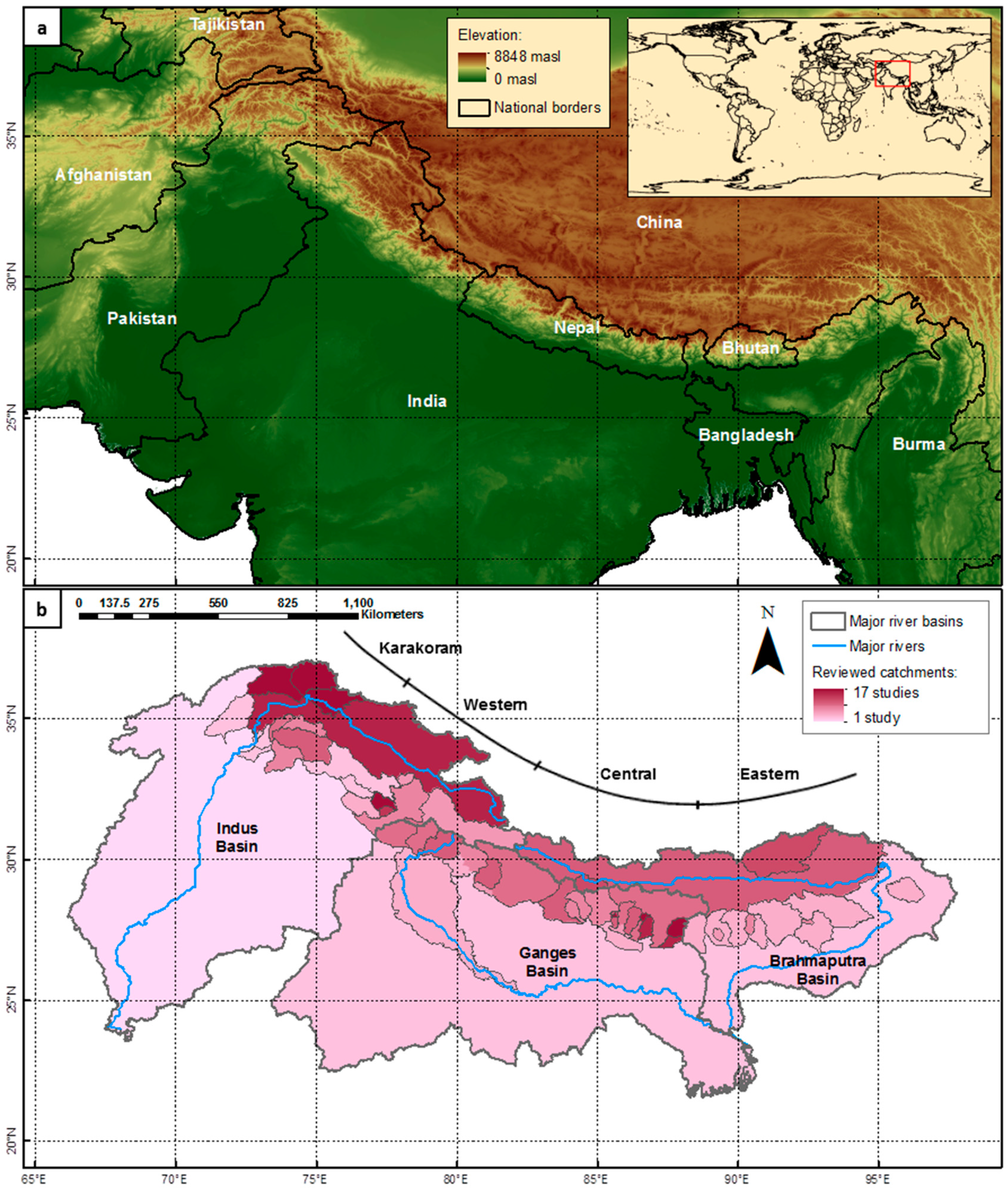
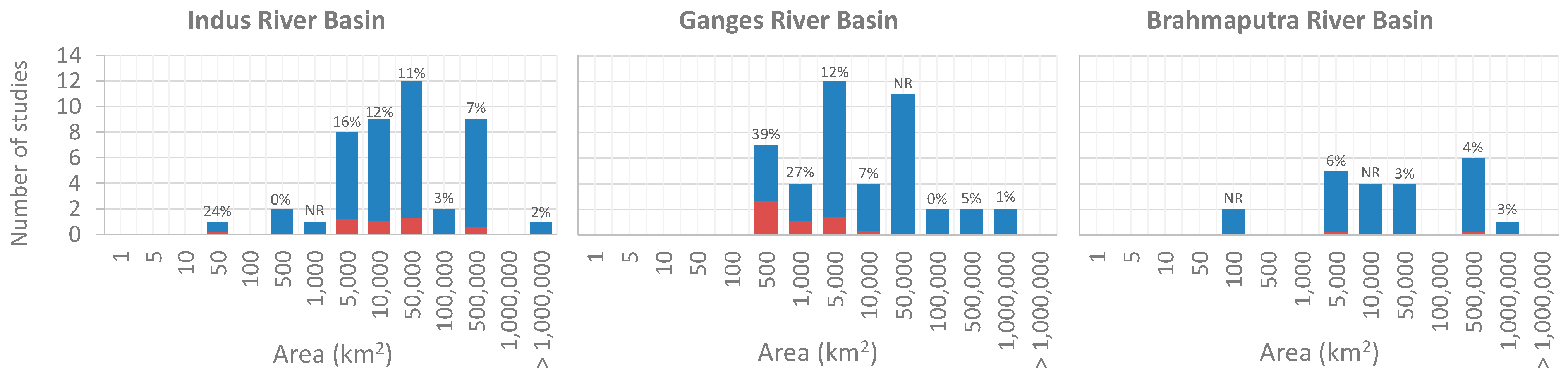
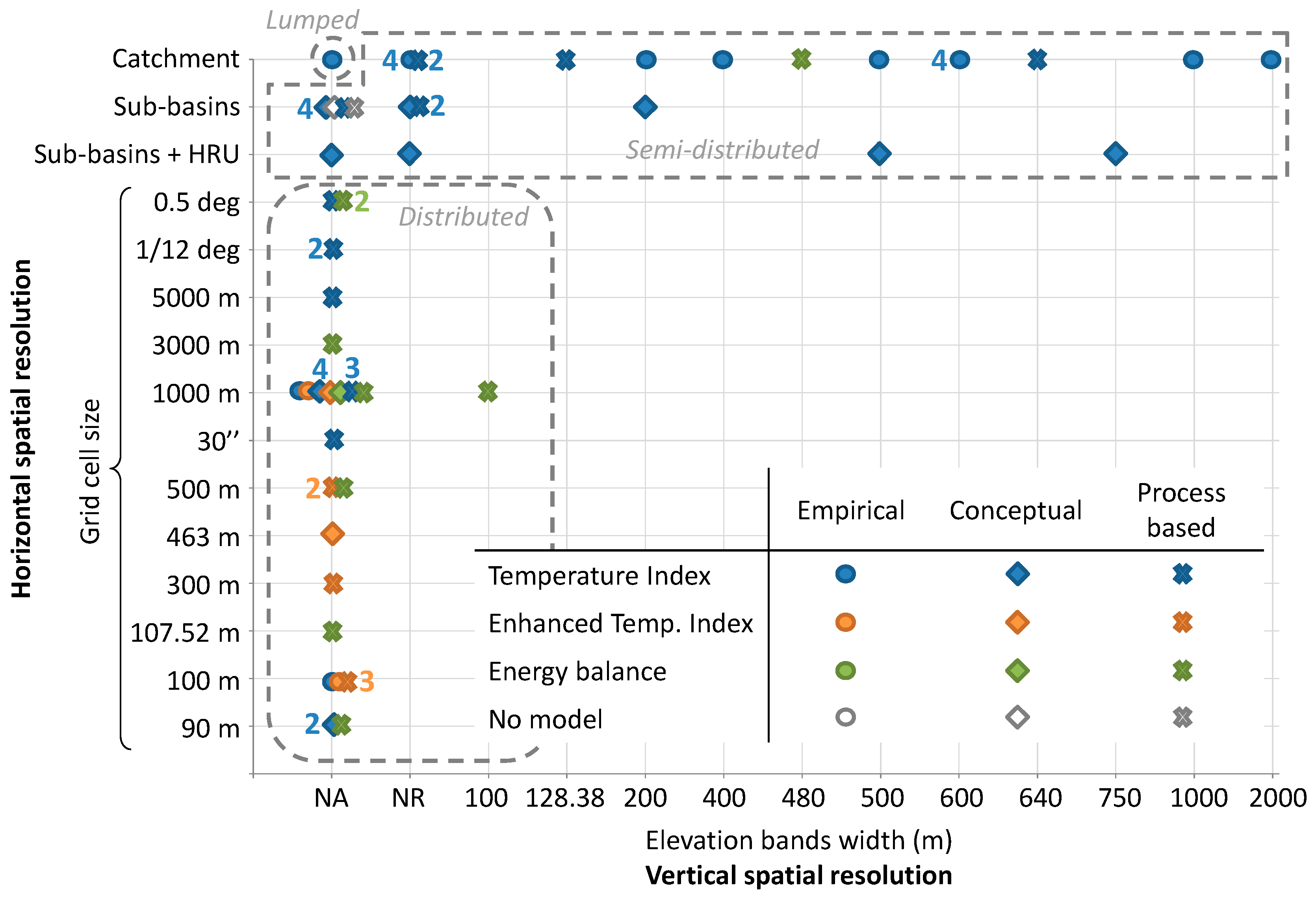
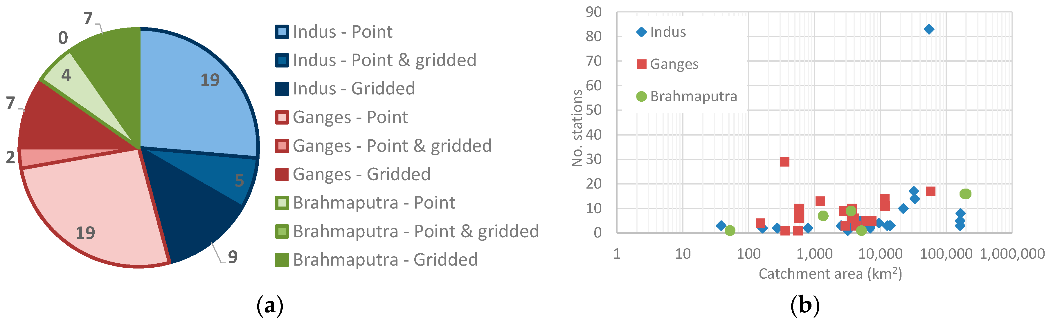
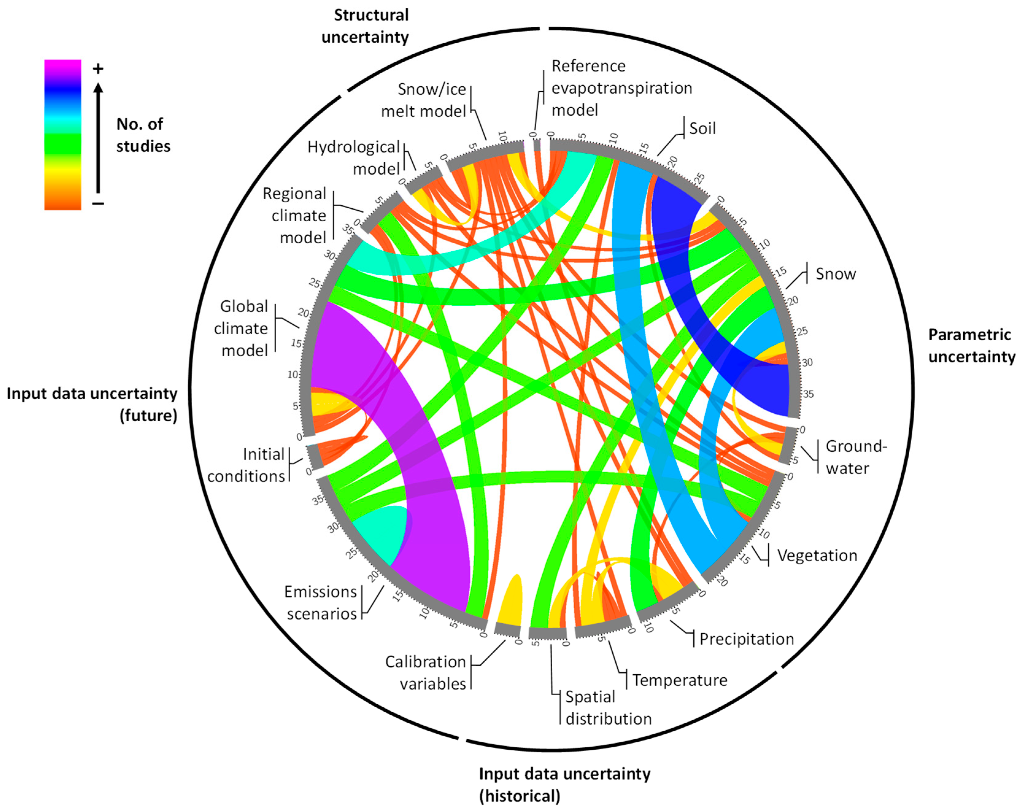
Table 1.
Primary (rows) and secondary (columns) purpose for the application of hydrological models in Himalayan catchments and number of reviewed studies that address each of them.
Table 1.
Primary (rows) and secondary (columns) purpose for the application of hydrological models in Himalayan catchments and number of reviewed studies that address each of them.
| Modelling Purpose | Climate Change Impacts | Understanding Basin Behaviour | Assessing Model Performance | Land-Use Change Impacts |
|---|---|---|---|---|
| Climate Change Impacts | 23 | 0 | 0 | 1 |
| Understanding Basin Behaviour | 5 | 15 | 0 | 0 |
| Assessing Model Performance | 4 | 6 | 10 | 0 |
| Land-Use Change Impacts | 0 | 0 | 0 | 1 |
| Water Quality Impacts | 1 | 0 | 0 | 0 |
© 2019 by the authors. Licensee MDPI, Basel, Switzerland. This article is an open access article distributed under the terms and conditions of the Creative Commons Attribution (CC BY) license (http://creativecommons.org/licenses/by/4.0/).
Share and Cite
MDPI and ACS Style
Momblanch, A.; Holman, I.P.; Jain, S.K. Current Practice and Recommendations for Modelling Global Change Impacts on Water Resource in the Himalayas. Water 2019, 11, 1303. https://0-doi-org.brum.beds.ac.uk/10.3390/w11061303
AMA Style
Momblanch A, Holman IP, Jain SK. Current Practice and Recommendations for Modelling Global Change Impacts on Water Resource in the Himalayas. Water. 2019; 11(6):1303. https://0-doi-org.brum.beds.ac.uk/10.3390/w11061303
Chicago/Turabian StyleMomblanch, Andrea, Ian P. Holman, and Sanjay K. Jain. 2019. "Current Practice and Recommendations for Modelling Global Change Impacts on Water Resource in the Himalayas" Water 11, no. 6: 1303. https://0-doi-org.brum.beds.ac.uk/10.3390/w11061303
Note that from the first issue of 2016, this journal uses article numbers instead of page numbers. See further details here.