Hazards, Vulnerability, and Risk Analysis on Wave Overtopping and Coastal Flooding in Low-Lying Coastal Areas: The Case of Costa da Caparica, Portugal

 ,
, 
 and
and 
Abstract
:1. Introduction
- Sea level rise: coastal flooding, coastal overtopping, submergence of low-lying coastal areas, erosion, salinization of coastal aquifers, rise in groundwater level causing problems in drainage systems, loss of wetlands;
- Storms (increased frequency and intensity): sea level rise, storm surges, overtopping, astronomical tides, coastal flooding, salinization of coastal aquifers, groundwater level rise causing problems in drainage systems, loss of wetlands, infrastructures, buildings, and coastal defenses destruction;
- Winds: rising water phenomena, high currents, coastal defenses destruction;
- Waves: coastal erosion, coastal overtopping and coastal flooding;
- Ocean surface temperature: changes in water stratification and water movement, thermal expansion of the oceans, increasing defrost, death of corals, ecosystems changes;
- Change in the chemical composition of the water: ocean acidification, PH reduction, CO2 increase, desalination, deoxygenation.

| Methodology | Definition |
|---|---|
| Coastal Vulnerability Index (CVI) | Classifies the study area according to variables that substantiate the problem under study using GIS [13,31,32,33,34,35,36,37]. |
| Social Vulnerability Index (SoVI) | It classifies the social vulnerability of a study area and uses a multicriteria analysis model with social and economic variables to assess the vulnerability. Although, in reality, the different social factors display different degrees of social importance, in this model, all the variables exhibit the same degree of importance [13,38]. |
| Overall Place Vulnerability Index (PVI) | It results from the sum between the coastal vulnerability index and the social vulnerability index. This index identifies the areas at coastal risk, integrating the physical factors of the study area with the socioeconomic indicators of the community [39]. Although the physical, social, and economical factors contribute to coastal risk at different degrees of importance, they display the same contribution to the global index calculation. This index is an indicator of the static risk of physical and socioeconomic conditions in a given location, since it allows for scenarios. Mitigation factors, such as the defense structures present at the site, are not considered. Ecological factors are not considered as well. |
| Simple Multi-Attribute Rating Technique | This index is based on the identification of relevant factors or criteria of the problem to be identified (danger, risk, vulnerability), and their weighting (carried out by specialists) in relation to their importance for the problem to be assessed and the respective classification in the study area [40]. |
| Classification of vulnerability, exposure, and risk of sea action | Weighted Analytic Hierarchy Process methodology (AHP) for the classification of vulnerability, exposure, and risk of sea action, with the aim of delimiting risk areas. It does not take into account several important variables for the study of coastal risk, such as: historical data on overtopping and flooding; existing species and ecosystems on the coast; existing cultural heritage; wave period and frequency of sea actions [13,41]. |
| Development of an Information Technology Tool for the management of European southern lagoons under the influence of river-basin runoff—Decision Support System (DITTY-DSS model) | Risk analysis model which uses a Decision Support System (DSS) approach and a weighted multicriteria analysis (AHP). The DSS system is represented by mathematical and analytical models and the multicriteria analysis is applied to evaluate and classify alternatives based on the values of indicators and interaction with the decision-maker [42]. |
| Community Vulnerability Assessment Tool Methodology | Methodology for analyzing the risks and vulnerabilities of communities using GIS. It analyzes infrastructure, environmental vulnerability, social vulnerability, economic vulnerability, as well as mitigation opportunities. The hazard identification process uses objective and qualitative variables to classify the total hazard, not evaluating the probabilities or frequencies of the problematic events [43]. |
| Vulnerability to disaster mapping method in densely populated coastal communities | It is a decision support model that assesses the risk of climate change at the regional level. The model is based on a multicriteria analysis (AHP) and uses GIS to identify the hazard, exposure, susceptibility, risk and damage assessment from climatic scenarios and the physical, environmental, and socioeconomic characteristics of the study area. High resolution numerical models are used to analyze the risk [44]. |
| Coastal Zone Simulation Mode (COSMO) | It is a GIS model used to support decision-making and it allows for the assessment of potential management strategies under different long-term scenarios, including climate change, local economic development, or the development of other uses. This model has interactive tools that allow coastal managers to assess the impacts of development projects and environmental and coastal protection measures. It makes it possible to relate climate change to its adaptation in coastal areas and to identify the advantages and disadvantages of each strategy [45,46]. |
| Decision Support System for Coastal Climate Change (DESYCO) | DESYCO is a GIS model and it works as a decision support system that assesses the risk of climate change at the regional level and defines the context for planning strategic adaptation measures on the coast. This model is based on a weighted multicriteria analysis of decision, whose aim is identifying the danger, exposure, susceptibility, risk and damage assessment from climatic scenarios and the physical, environmental, and socioeconomic characteristics of the study area. Risk analysis uses data from climate simulations and simulations of physical processes performed by high resolution numerical models for the study area. The simulations can be related to different scenarios of greenhouse gas emissions and aerosols. For hazard scenarios, data from time series of climatic variables and extreme events are required. The vulnerability analysis analyzes four main categories of factors: susceptibility, value, mitigation and forcing. This model integrates multidisciplinary and heterogeneous information from environmental and socioeconomic scenarios in a multicriteria analysis structure based on the judgment of experts and key actors. It has already been applied to different European projects, which proves its flexibility [47]. |
| Dynamic and Interactive Vulnerability Assessment (DIVA) | The DIVA method was developed to facilitate the integration of multidisciplinary knowledge from specialists to create vulnerability calculation tools. This tool consists of three major components: a coastal database; an integrated model of modules with natural and social knowledge of coastal subsystems; a graphical user interface for selecting data and scenarios, running model simulations, and analyzing results. This model predicts the impacts of sea level rise scenarios on natural and human systems, as well as the effects of the human response to these impacts through adaptation measures. It is a robust tool for assessing vulnerability on a global, national, or regional scale. It does not, however, consider ecologically based adaptation measures [48,49,50,51]. |
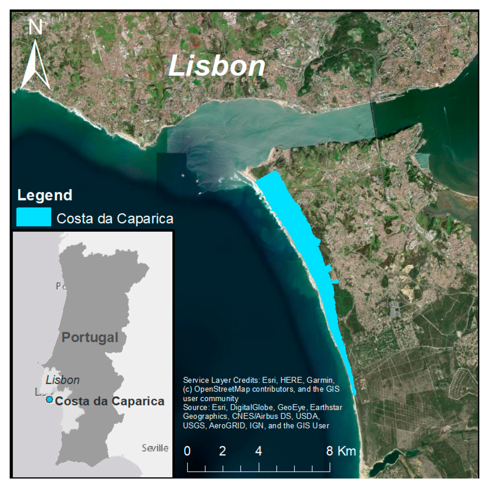
2. Study Site
3. Methods
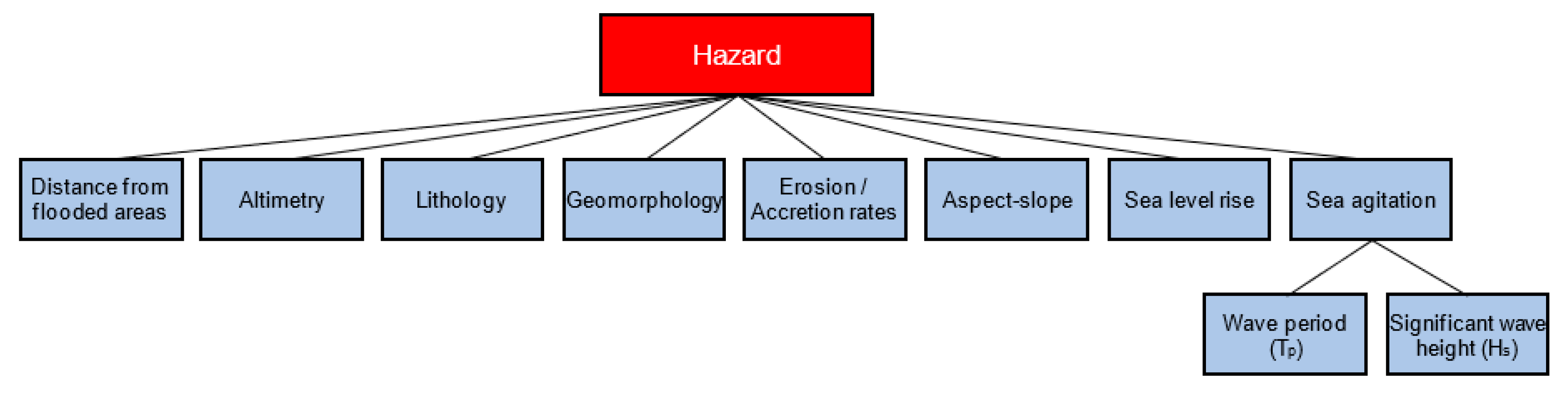
3.1. Hazard Factors
3.1.1. Distance from Flooded Areas
3.1.2. Altimetry
3.1.3. Lithology
3.1.4. Geomorphology
3.1.5. Erosion/Accretion Rates
3.1.6. Slope and Slope Exposure
3.1.7. Sea Level Rise (SLR)
3.1.8. Sea Agitation
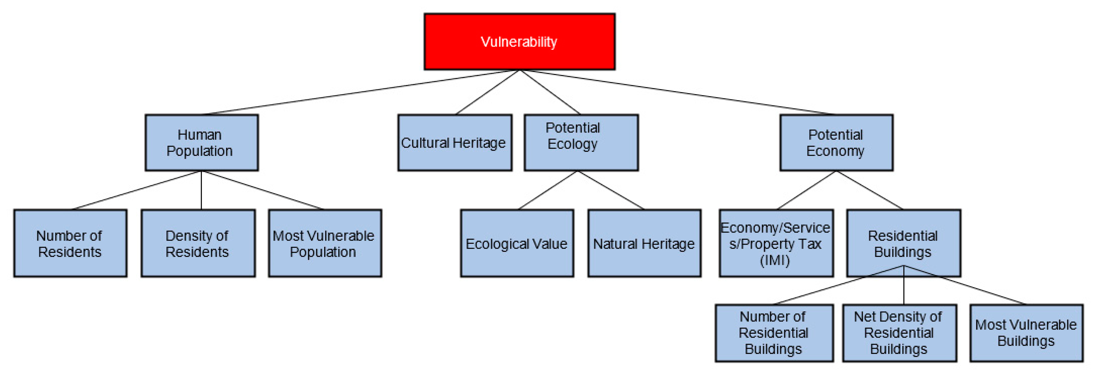
3.2. Vulnerability Factors
3.2.1. Human Population
- Number of residents (INE defines “residents” as the people who live at their usual residence for a continuous period of at least 12 months prior to the observation moment): the estimated number of residents in the statistical subsection located in the study area;
- Net density of residents: the ratio between the number of residents in the statistical subsection located in the study area and the residential area of the respective subsection. It should be noted that the area considered in this calculation is not the total area of the subsection, but only the residential area of the respective subsection.
- Most vulnerable population: the ratio of the population residing in the statistical subsection under the age of 10 years and over 64 years, with the total number of residents of the respective sub-section.
3.2.2. Potential Economy
- Number of residential buildings: the number of classic buildings (INE defines “classic buildings” as a building whose structure and materials used in its construction are non-precarious and expected to last at least 10 years) in the subsection located in the study area;
- Net density of residential buildings: the ratio between the number of residential buildings present in the statistical subsection and the residential area of the respective subsection. The area used in this calculation is not the total area of the subsection, but only the residential area;
- Vulnerable buildings: the ratio between the number of residential buildings with less than 2 floors (inclusive) in the subsection and the total number of residential buildings in the respective subsection.
3.2.3. Potential Ecology
3.2.4. Cultural Heritage
3.3. Weighting of the Hazard and Vulnerability Factors
3.4. Attaining Hazard, Vulnerabiltiy, and Risk Indexes
- Construction of a digital georeferenced database in the study area with the criteria and sub-criteria defined in Section 3.1. and Section 3.2. of the present work, with a view to spatial analysis in a GIS environment. The criteria mapped in the study area in vector form;
- Conversion of vector data to raster data, so that they can be analyzed matrix-wise and so that mathematical operations between them are possible. When converting these data, we transfer the classification information of the criteria from the vector file to the raster file. As a result of this step, there is a georeferenced raster file for each hazard and vulnerability factor, where each pixel refers to a classification between 1 and 5, according to the classification mentioned in Section 3.1 and Section 3.2;
- Obtaining the hazard and vulnerability index. The values (between 1 and 5) referring to each factor are crossed with the respective weighting, using the Raster Calculator™ tool, which, through spatial matrix analysis, adds the weighted value of each factor equation (Equations (1) and (2)), resulting in an index. This means these equations are applied to each pixel of the georeferenced raster image, resulting in a value between 1 and 5 for each pixel. This method of obtaining hazard and vulnerability indexes, using the weighted sum, was recommended by Gornitz et al. [33] and used by Yin et al. [68].where,
- distance from flooded areas: The value (between 1 and 5) of the pixel under analysis of the georeferenced raster file was classified, according to this criterion, present in the study area;
- altimetry: The value (between 1 and 5) of the pixel under analysis of the georeferenced raster file was classified, according to this criterion, present in the study area;
- lithology: The value (between 1 and 5) of the pixel under analysis of the georeferenced raster file was classified, according to this criterion, present in the study area;
- geomorphology: The value (between 1 and 5) of the pixel under analysis of the georeferenced raster file was classified, according to this criterion, present in the study area;
- erosion/accretion rates: The value (between 1 and 5) of the pixel under analysis of the georeferenced raster file was classified, according to this criterion, present in the study area;
- slope and slope exposure: The value (between 1 and 5) of the pixel under analysis of the georeferenced raster file was classified, according to this criterion, present in the study area;
- SLR: The value (between 1 and 5) of the pixel under analysis of the georeferenced raster file was classified, according to this criterion, present in the study area;
- sea agitation: The value (between 1 and 5) of the pixel under analysis of the georeferenced raster file was classified, according to this criterion, present in the study area;
- W: weighting factor attributed to the criterion for the pixel under analysis;
- P: hazard classification of the criterion for the pixel under analysis.
where,- res.: The value (between 1 and 5) of the pixel under analysis of the georeferenced raster file was classified, according to the sub-criterion Number of Residents, present in the study area;
- res./area: The value (between 1 and 5) of the pixel under analysis of the georeferenced raster file was classified, according to the sub-criterion Density of Residents, present in the study area;
- vuln.pop.: The value (between 1 and 5) of the pixel under analysis of the georeferenced raster file was classified, according to the sub-criterion Vulnerable Population, in the study area;
- economy/services/IMI: The value (between 1 and 5) of the pixel under analysis of the georeferenced raster file was classified, according to the sub-criterion Economy/Services/IMI, present in the study area;
- build.: The value (between 1 and 5) of the pixel under analysis of the georeferenced raster file was classified, according to the sub-criterion Residential Buildings, present in the study area;
- build./area: The value (between 1 and 5) of the pixel under analysis of the georeferenced raster file was classified, according to the sub-criterion Net Density of Residential Buildings, present in the study area;
- vuln.build.: The value (between 1 and 5) of the pixel under analysis of the georeferenced raster file was classified, according to the sub-criterion Density of Vulnerable Buildings, present in the study area;
- eco.value: The value (between 1 and 5) of the pixel under analysis of the georeferenced raster file was classified, according to the sub-criterion Ecological value, present in the study area;
- nat.heritage: The value (between 1 and 5) of the pixel under analysis of the georeferenced raster file was classified, according to the sub-criterion Natural Heritage, present in the study area;
- cult.heritage: The value (between 1 and 5) of the pixel under analysis of the georeferenced raster file was classified, according to the sub-criterion Cultural Heritage, present in the study area;
- W: weighting factor attributed to the criterion for the pixel under analysis;
- V: vulnerability classification of the criterion for the pixel under analysis.
- Obtaining the risk index through the weighted sum between the hazard index and the vulnerability index. A weighting of 80% was attributed to the hazard, whereas a 20% weighting was attributed to vulnerability, since in the peer-to-peer classification it was considered that the hazard would have an intermediate value between the “strongly important” and the “most important” when compared to vulnerability. Hence, the risk index map results from the weighted sum of vulnerability and danger, obtained with the aid of the Raster CalculatorTM of ArcGis. Table 15 shows the classification matrix for the risk of overtopping and coastal flooding in the study area (Costa da Caparica) resulting from the weighted sum between the hazard index and the vulnerability index (Equation (3)). The colors were added to facilitate the identification of the different levels for each index, as they will be represented in the resulting indexes.where R: risk for the pixel under analysis; W: weighting factor attributed to the criterion; P—hazard classification of the criterion for the pixel under analysis; V: vulnerability classification of the criterion for the pixel under analysis.
4. Results
4.1. Weighting of the Hazard and Vulnerability Factors
4.2. Hazard Factors
4.2.1. Distance from Flooded Areas
4.2.2. Altimetry
4.2.3. Lithology
4.2.4. Geomorphology
4.2.5. Erosion/Accretion Rates
4.2.6. Slope and Slope Exposure
4.2.7. Sea Level Rise (SLR) Increase
4.2.8. Sea Agitation
4.3. Vulnerability Factors
4.3.1. Human Population
Number of Residents
Density of Residents
Most Vulnerable Population
4.3.2. Potential Economy
Economy/Services/IMI
Residential Buildings
Number of Residential Buildings
Net Density of Residential Buildings
Most Vulnerable Residential Buildings
4.3.3. Potential Ecology
Natural Heritage
Ecological Value
4.3.4. Cultural Heritage
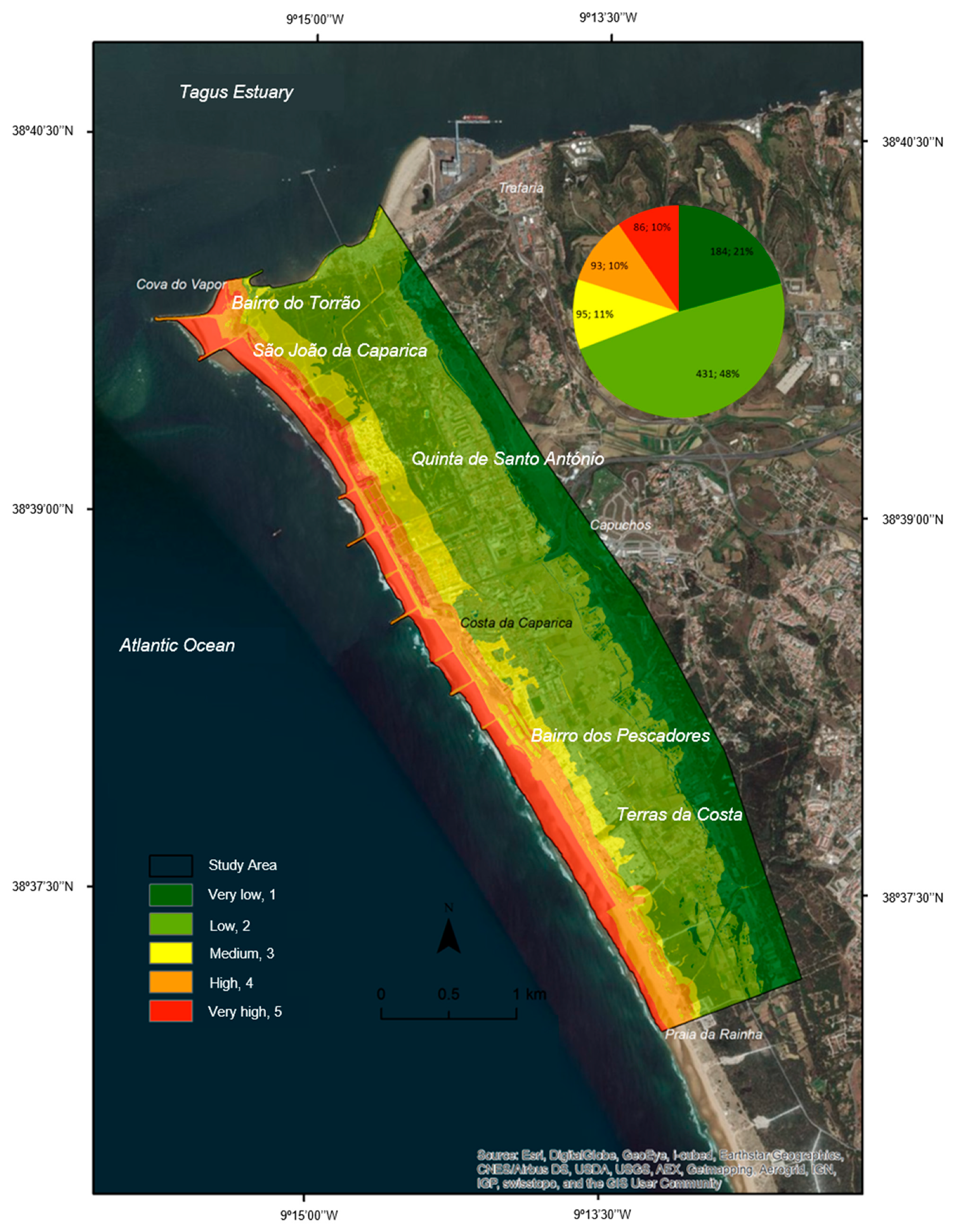
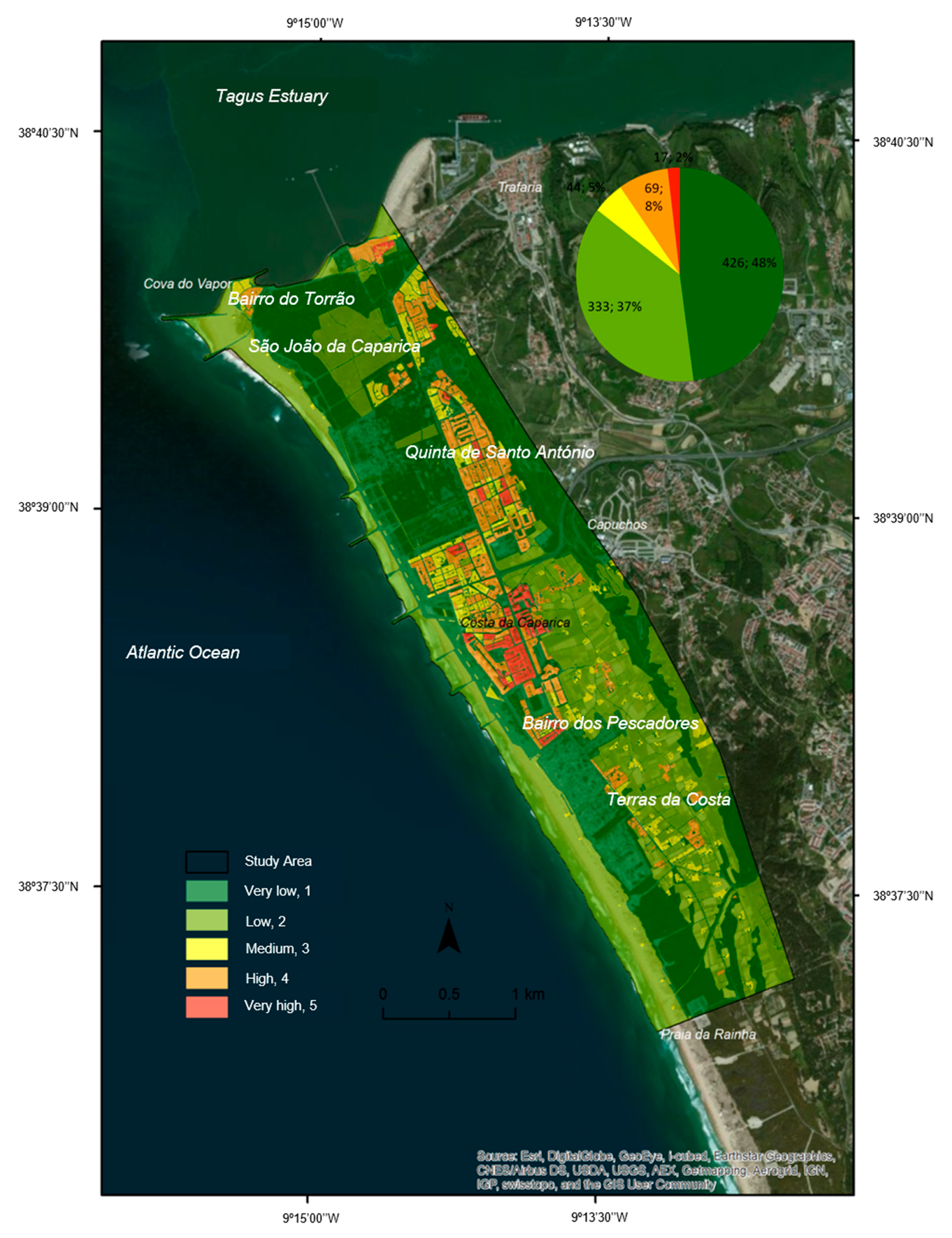
4.4. Global Hazard Index to Overtopping and Coastal Flooding
4.5. Global Vulnerability Index to Overtopping and Coastal Flooding
4.6. Global Risk Index to Overopping and Coastal Flooding
5. Discussion
6. Conclusions
Author Contributions
Funding
Institutional Review Board Statement
Informed Consent Statement
Acknowledgments
Conflicts of Interest
References
- Duarte, C.M.; Ferreira, J.C.; Fortes, J. Risk modelling in urban coastal areas to support adaptation to climate change and extreme weather events: Early warning, emergency planning and risk management system. J. Coast. Res. 2020, SI95. [Google Scholar] [CrossRef]
- Hunter, J. Estimating sea-level extremes under conditions of uncertain sea-level rise. Clim. Chang. 2010, 99, 331–350. [Google Scholar] [CrossRef]
- Reay, D.; Sabine, C.; Smith, P.; Hymus, G. Intergovernmental Panel on Climate Change; Fourth Assessment Report; Inter-Gov- Ernmental Panel on Climate Change: Geneva, Switzerland; Cambridge University Press: Cambridge, UK, 2007; ISBN 9291691224. Available online: www.ipcc.ch (accessed on 5 September 2020).
- United Nations and Canada. United Nations Framework Convention on Climate Change; United Nations, General Assembly: New York, NY, USA, 1992. [Google Scholar]
- NASA/GISS Long-Term Warming Trend Continued in 2017: NASA, NOA. Available online: https://climate.nasa.gov/news/2671/long-term-warming-trend-continued-in-2017-nasa-noaa/ (accessed on 5 September 2020).
- Howard, T.; Pardaens, A.K.; Bamber, J.L.; Ridley, J.; SPada, G.L.; Hurkmans, R.T.W.; Lowe, J.A.; Vaughan, D. Sources of 21st century regional sea-level rise along the coast of northwest Europe. Ocean Sci. 2014, 10, 473–483. [Google Scholar] [CrossRef] [Green Version]
- Wong, P.P.; Losada, I.J.; Gattuso, J.P.; Hinkel, J.; Khattabi, A.; McInnes, K.L.; Saito, Y.; Sallenger, A. Coastal Systems and Low-Lying Areas. In Climate Change 2014: Impacts, Adaptation, and Vulnerability. Part A: Global and Sectoral Aspects. Contrivution of Working Group II to the Fifth Assessment Report of the Intergovernmental Panel on Climate Change; Field, C.B., Barros, V.R., Dokken, D.J., Mach, K.J., Mastrandrea, M.D., Bilir, T.E., Chatterjee, M., Ebi, K.L., Estrada, Y.O., Genova, R.C., et al., Eds.; Cambridge University Press: Cambridge, UK; New York, NY, USA, 2014; pp. 361–409. ISBN 9781107415379. [Google Scholar]
- Santos, F.D.; Miranda, P. Alterações Climáticas em Portugal. Cenários, Impactos e Medidas de Adaptação. Projeto SIAM II, 1st ed.; Gradiva Publicações, Lda.: Lisbon, Portugal, 2006; ISBN 989-616-081-3. [Google Scholar]
- Dias, J.A.; Ferreira, Ó.; Pereira, A.R. Estudo Sintético de Diagnóstico da Geomorfologia e da Dinâmica Sedimentar dos Troços Costeiros Entre Espinho e Nazaré; ESAMIN—Estudos de Ambiente e Informática, Lda.: Lisbon, Portugal, 1994. [Google Scholar]
- Ribeiro, J.L. Cadernos Técnicos PROCIV: Riscos Costeiros—Estratégias de prevenção, mitigação e protecção, no âmbito do planeamento de emergência e do ordenamento do território; Autoridade Nacional de Proteção Civil, Ed.; ANPC: Carnaxide, Portugal, 2010; pp. 1–156. [Google Scholar]
- Ferreira, J. Coastal zone vulnerability and risk evaluation: A tool for decision-making (an example in the Caparica Littoral-Portugal). J. Coast. Res. 2004, 39, 1590–1593. [Google Scholar]
- Raposeiro, P.D.; Reis, M.T.; Fortes, C.J.; Ferreira, J.C. Methodology for estimating run-up and flooding at the costal zone using the GUIOMAR system: Application to Vale do Lobo beach. In Proceedings of the Conference: CoastGIS 2009, Oeiras, Portugal, 13 November 2009; Volume 2. [Google Scholar]
- Ferreira, J.C.R. Ordenamento Ambiental de Frentes Urbanas Litorais em Áreas Baixas de Elevado Risco e Vulnerabilidade ao Galgamento Costeiro. 2016. Available online: http://hdl.handle.net/10362/19883 (accessed on 5 September 2020).
- Turner, R.K.; Burgess, D.; Hadley, D.; Coombes, E.; Jackson, N. A cost-benefit appraisal of coastal managed realignment policy. Glob. Environ. Chang. 2007, 17, 397–407. [Google Scholar] [CrossRef]
- Cooper, J.A.G.; McKenna, J. Social justice in coastal erosion management: The temporal and spatial dimensions. Geoforum 2008, 39, 294–306. [Google Scholar] [CrossRef]
- Dias, J.A. Evolução da Zona Costeira Portuguesa: Forçamentos Antrópicos e Naturais. Encontros Científicos Turismo Gestão Fiscalidade 2005, 1, 7–27. [Google Scholar]
- Dias, J.A. A Evolução Actual do Litoral Português. Geonovas 1990, 11, 15–29. [Google Scholar]
- Yuhi, M. Impact of Anthropogenic Modifications of a River Basin on Neighboring Coasts: Case Study. J. Waterw. Port Coast. Ocean Eng. 2008, 134, 336–344. [Google Scholar] [CrossRef]
- Newell, R.C.; Seiderer, L.J.; Hitchcock, D.R. The impact of dredging works in coastal waters: A review of the sensitivity to disturbance and subsequent recovery of biological resources on the sea bed. Oceanogr. Mar. Biol. 1998, 36, 127–178. [Google Scholar]
- Cardona, F.M.S. Avaliação do Risco de Erosão, Galgamento e Inundação Costeira em Áreas Artificiais de Portugal Continental: Estratégias de Adaptação Face a Diferentes Cenários de Risco (Relocalização, Acomodação e Proteção); Faculdade de Ciências e Tecnologia, Universidade Nova de Lisboa: Caparica, Portugal, 2015; p. 206. [Google Scholar]
- French, P.W. Coastal Defences: Processes, Problems and Solutions, 1st ed.; Routledge: Abingdon, UK, 2001. [Google Scholar]
- Bernatchez, P.; Fraser, C. Evolution of coastal defence structures and consequences for beach width trends, Québec, Canada. J. Coast. Res. 2012, 28, 1550–1566. [Google Scholar] [CrossRef]
- Martinho, M.F.M.A. Avaliação e Gestão de Riscos em Áreas Litorais. Contributo para o Desenvolvimento de um Sistema de Previsão e Alerta de Inundação em Zonas Costeiras; Faculdade de Ciências e Tecnologia, Universidade Nova de Lisboa: Caparica, Portugal, 2014; p. 131. [Google Scholar]
- Matos, M.D.F.A.D.; Fortes, C.J.E.M.; Amaro, V.E.; Scudelari, A.C. Análise Comparativa da Agitação Obtida com o Modelo Numérico (SWAN) na Modelagem de Ondas do Litoral Setentrional do Rio Grande do Norte, Brasil e Dados de Campo. Rev. Gestão Costeira Integr. 2013, 13, 283–299. [Google Scholar] [CrossRef]
- Raposeiro, P.D.; Ferreira, J.C. Evaluation of Coastal Flood Risk Areas and Adaptation Strategie for a Sustainable Planning. J. Coast. Res. 2011, SI 64, 1896–1900. [Google Scholar]
- Neves, P.; Poseiro, P.; Fortes, C.J.; Reis, M.T.; Capitão, R.; Antunes do Carmo, J.S.; Raposeiro, P.; Ferreira, J.C. O Projeto Hidralerta—Sistema de Previsão e Alerta de Inundações Costeiras e Portuárias. In Proceedings of the 8ªs Jornadas Portuguesas de Engenharia Costeira e Portuária, Lisboa, Portugal, 10–11 October 2013. [Google Scholar]
- Poseiro, P.; Fortes, C.; Reis, M.; Santos, J.; Reis, R. Aplicações Do Sistema De Previsão E Alerta Do Risco De Galgamentos Em Zonas Costeiras E Portuárias: Costa Da Caparica E Praia Da Vitória. Rev. Eng. E Tecnol. 2014, 7, 77–91. [Google Scholar]
- Fortes, C.J.E.M.; Reis, M.T.; Poseiro, P.; Santos, J.A.; Pinheiro, L.; Craveiro, J.; Rodrigues, A.; Sabino, A.; Silva, S.F.; Ferreira, J.C.; et al. HIDRALERTA Project: A Flood Forecast and Alert System in Coastal and Port Areas. In Proceedings of the IWA—World Water Congress & Exhibition, Lisbon, Portugal, 21–26 September 2014. [Google Scholar] [CrossRef]
- Poseiro, P.; Capitão, R.; Fortes, C.; Silva, S.; Ferreira, J.C. Relatório do Levantamento de Perfis Morfológicos do Sistema Praia-duna da Costa da Caparica, entre Cova do Vapor e Ribeira Foz do Rego 29 e 30 de abril de 2014; Laboratório Nacional de Engenharia Civil: Lisbon, Portugal, 2014; p. 78. [Google Scholar]
- Poseiro, P.; Reis, R.; Ferreira, J.C.; Fortes, C.; Capitão, R. Sistema de Previsão e Alerta de Inundações em Zonas Costeiras e Portuárias ptdc/aac-amb/120702/2010—Relatório do Levantamento de Perfis Morfológicos do Sistema Praia-duna da Costa da Caparica, entre Cova do Vapor e Ribeira Foz do Rego; Laboratório Nacional de Engenharia Civil: Lisbon, Portugal, 2014; p. 37. [Google Scholar]
- Denner, K.; Phillips, M.R.; Jenkins, R.E.; Thomas, T. A coastal vulnerability and environmental risk assessment of Loughor Estuary, South Wales. Ocean Coast. Manag. 2015, 116, 478–490. [Google Scholar] [CrossRef]
- Gornitz, V. Global coastal hazards from future sea level rise. Palaeogeogr. Palaeoclim. Palaeoecol. 1991, 89, 379–398. [Google Scholar] [CrossRef]
- Gornitz, V.M.; White, T.W. A coastal hazards data base for the U.S. east coast. Environ. Sci. Div. 1992, 174. [Google Scholar] [CrossRef] [Green Version]
- Kantamaneni, K. Counting the cost of coastal vulnerability. Ocean Coast. Manag. 2016, 132, 155–169. [Google Scholar] [CrossRef]
- Shaw, J.; Taylor, R.B.; Forbes, D.L.; Solomon, S.; Ruz, M.H. Sensitivity of the Coasts of Canada to Sea-Level Rise; Natural Resources Canada: Ottawa, QC, Canada, 1998; ISBN 0-660-17569-X.
- Thieler, E.R.; Hammar-Klose, E.S. National Assessment of Coastal Vulnerability to Sea-Level Rise: Preliminary Results for the U.S. Atlantic Coast U.S. Geological Survey Open-File Report 99–593. Available online: https://pubs.usgs.gov/of/1999/of99-593/ (accessed on 5 September 2020).
- Silva, S.F.; Martinho, M.; Capitão, R.; Reis, T.; Fortes, C.J.; Ferreira, J.C. An index-based method for coastal-flood risk assessment in low-lying areas (Costa de Caparica, Portugal). Ocean Coast. Manag. 2017, 144, 90–104. [Google Scholar] [CrossRef]
- Cutter, S.L.; Boruff, B.J.; Shirley, W.L. Social vulnerability to environmental hazards. Soc. Sci. Q. 2003, 84, 242–261. [Google Scholar] [CrossRef]
- Boruff, B.J.; Emrich, C.; Cutter, S.L. Erosion hazard vulnerability of US coastal counties. J. Coast. Res. 2005, 21, 932–942. [Google Scholar] [CrossRef] [Green Version]
- Gardiner, P.C.; Edwards, W. Public values: Multiattribute-utility measurement for social decision making. In Human Judgment and Decision Process, Academic Press Series in Cognition and Perception; Kaplan, M.F., Schwartz, S., Eds.; Academic Press: New York, NY, USA, 1975; pp. 1–37. [Google Scholar]
- Coelho, C.D.B. Riscos de Exposição de Frentes Urbanas para Diferentes Intervenções de Defesa Costeira; Universidade de Aveiro: Aveiro, Portugal, 2005. [Google Scholar]
- Marcomini, A.; Suter, G.W.; Critto, A. Decision Support. Systems for Risk-Based Management of Contaminated Sites; Marcomini, A., Critto, A., Sutter, G.W., II, Eds.; Springer: Berlin, Germany, 2009; ISBN 978-0-387-09721-3. [Google Scholar]
- Flax, L.K.; Jackson, R.W.; Stein, D.N. Community Vulnerability Assessment Tool Methodology. Nat. Hazards Rev. 2002, 3, 163–176. [Google Scholar] [CrossRef]
- Sherly, M.A.; Karmakar, S.; Parthasarathy, D.; Chan, T.; Rau, C. Disaster Vulnerability Mapping for a Densely Populated Coastal Urban Area: An Application to Mumbai, India. Ann. Assoc. Am. Geogr. 2015, 105, 1198–1220. [Google Scholar] [CrossRef]
- Taal, M. The cosmo-line: Interactive tools for ICZM. In Concepts, Tools and Measures—Climate of Coastal Cooperation; Misdorp, R., Ed.; Coastal and Marine Union: Leiden, The Netherlands, 2011; pp. 142–143. ISBN 978-90-75502-09-1. [Google Scholar]
- UNFCC. Decision Support Models: COSMO (Coastal Zone Simulation Model); UNFCC: Rio de Janeiro, Brazil, 2014. [Google Scholar]
- Torresan, S.; Critto, A.; Rizzi, J.; Zabeo, A.; Furlan, E.; Marcomini, A. DESYCO: A decision support system for the regional risk assessment of climate change impacts in coastal zones. Ocean Coast. Manag. 2016, 120, 49–63. [Google Scholar] [CrossRef]
- Hinkel, J. DIVA: An iterative method for building modular integrated models. Adv. Geosci. 2005, 4, 45–50. [Google Scholar] [CrossRef] [Green Version]
- Hinkel, J.; Klein, R.J.T. DINAS-COAST: Developing a Method and a Tool for Dynamic and Interactive Vulnerability Assessment. Land-Ocean Interact. Coast. Zone 2003, 27, 1–8. [Google Scholar]
- Hinkel, J.; Klein, R.J.T. Integrating Knowledge for Assessing Coastal Vulnerability to Climate Change. In Managing Coastal Vulnerability: An Integral Approach; McFadden, L., Nicholls, R.J., Penning-Rowsell, E.C., Eds.; Emerald Group Publishing, Ltd.: Bingley, UK, 2008; pp. 1–20. [Google Scholar]
- Hinkel, J.; Nicholls, R.J.; Vafeidis, A.T.; Tol, R.S.J.; Avagianou, T. Assessing risk of and adaptation to sea-level rise in the European Union: An application of DIVA. Mitig. Adapt. Strateg. Glob. Chang. 2010, 15, 703–719. [Google Scholar] [CrossRef] [Green Version]
- Zêzere, J.L. Movimentos de Vertente e Perigosidade Geomorfológica na Região a Norte de Lisboa; Faculdade de Letras da Universidade de Lisboa: Lisbon, Portugal, 1997. [Google Scholar]
- Bankoff, G. Vulnerability as a Measure of Change in Society. Int. J. Mass Emerg. Disasters 2003, 21, 5–30. [Google Scholar]
- Birkmann, J. Risk and vulnerability indicators at different scales: Applicability, usefulness and policy implications. Environ. Hazards 2007, 7, 20–31. [Google Scholar] [CrossRef]
- Shepard, C.C.; Agostini, V.N.; Gilmer, B.; Allen, T.; Stone, J.; Brooks, W.; Beck, M.W. Assessing future risk: Quantifying the effects of sea level rise on storm surge risk for the southern shores of Long Island, New York. Nat. Hazards 2012, 60, 727–745. [Google Scholar] [CrossRef]
- UN/ISDR. Living with Risk: A Global Review of Disaster Reduction Initiatives, 1st ed.; United Nations: Geneve, Switzerland, 2004; ISBN 92-1-101050-0. [Google Scholar]
- UN/ISDR. 2009 UNISDR Terminology on Disaster Risk Reduction; International Strategy for Disaster Reduction: Geneve, Switzerland, 2009. [Google Scholar]
- Julião, R.; Nery, F.; Ribeiro, J.; Branco, M.; Zêzere, J. Guia Metodológico Para a Produção de Cartografia Municipal de Risco e Para a Criação de Sistemas de Informação Geográfica (SIG) de Base Municipal; Autoridade Nacional de Proteção Civil, Ed.; ANPC: Carnaxidade, Portugal, 2009; ISBN 978-989-96121-4-3. [Google Scholar]
- UNDP. Reducing Disaster Risk: A Challenge for Development-a Global Report; United Nations Development Programme—Bureau for Crisis Prevention and Recovery: New York, NY, USA, 2004; ISBN 9211261600. [Google Scholar]
- Ni, H.; Chen, A.; Chen, N. Some extensions on risk matrix approach. Saf. Sci. 2010, 48, 1269–1278. [Google Scholar] [CrossRef]
- Carter, D.A.; Hirst, I.L.; Maddison, T.E.; Porter, S.R. Appropriate risk assessment methods for major accident establishments. Process. Saf. Environ. Prot. Trans. Inst. Chem. Eng. Part. B 2003, 81, 12–18. [Google Scholar] [CrossRef]
- WMO. Comprehensive Risk Assessment for Natural Hazards; World Meteorological Organization—Hydrology and Water Resources Department: Geneva, Switzterland, 2006. [Google Scholar]
- Santos, C.J.; Andriolo, U.; Ferreira, J.C. Shoreline response to a sandy nourishment in a wave-dominated coast using video monitoring. Water 2020, 12, 1632. [Google Scholar] [CrossRef]
- Saaty, T.L. How to make a decision: The analytic hierarchy process. Eur. J. Oper. Res. 1990, 48, 9–26. [Google Scholar] [CrossRef]
- Stockdon, H.F.; Holman, R.A.; Howd, P.A.; Sallenger, A.H. Empirical parameterization of setup, swash, and runup. Coast. Eng. 2006, 53, 573–588. [Google Scholar] [CrossRef]
- Mani Murali, R.; Ankita, M.; Amrita, S.; Vethamony, P. Coastal vulnerability assessment of Puducherry coast, India, using the analytical hierarchical process. Nat. Hazards Earth Syst. Sci. 2013, 13, 3291–3311. [Google Scholar] [CrossRef] [Green Version]
- Mihoubi, M.K.; Belkessa, R.; Latreche, M.A. Study of the Vulnerability of Coastal Areas of the Algerian Basin with the GIS. Int. J. Environ. Sci. Dev. 2014, 5, 522–526. [Google Scholar] [CrossRef] [Green Version]
- Yin, J.; Yin, Z.; Wang, J.; Xu, S. National assessment of coastal vulnerability to sea-level rise for the Chinese coast. J. Coast. Conserv. 2012, 16, 123–133. [Google Scholar] [CrossRef]
- Bruno, M.F.; Saponieri, A.; Molfetta, M.G.; Damiani, L. The DPSIR approach for coastal risk assessment under climate change at regional scale: The case of apulian coast (Italy). J. Mar. Sci. Eng. 2020, 8, 531. [Google Scholar] [CrossRef]
- Cardona, F.S.; Ferreira, J.C.; Lopes, A.M. Cost and Benefit Analysis of Climate Change Adaptation Strategies in Coastal Areas at Risk. J. Coast. Res. 2020, 95, 764–768. [Google Scholar] [CrossRef]


| Hazard Classes | |||||
|---|---|---|---|---|---|
| Hazard Factor | Very Low 1 | Low 2 | Medium 3 | High 4 | Very High 5 |
| Distance from flooded areas in the last 35 years (m) | >300 | 100–300 | 50–100 | <50 | Flooded areas in the last 35 years |
| Hazard Classes | |||||
|---|---|---|---|---|---|
| Hazard Factor | Very Low 1 | Low 2 | Medium 3 | High 4 | Very High 5 |
| Altimetry | >10 | 7–10 | 5–7 | 3–5 | <3 |
| Hazard Classes | |||||
|---|---|---|---|---|---|
| Hazard Factor | Very Low 1 | Low 2 | Medium 3 | High 4 | Very High 5 |
| Lithology | Clays and landfill (coastal defense infrastructure) | Conglomerates with clay intercalations | Limestone, sand, sandstones, and marly limestones | Screes, feldspathic sand, incoherent or compact, sandy conglomerate | Beach sand, dunes sand, and alluvial soil |
| Hazard Classes | |||||
|---|---|---|---|---|---|
| Hazard Factor | Very Low 1 | Low 2 | Medium 3 | High 4 | Very High 5 |
| Geomorphology | Cliff and coastal defenses | Slope deposits (cliff base) | Coastal plan and interior dunes | Drainage ditches | Beaches, waterline and frontal dunes |
| Hazard Classes | |||||
|---|---|---|---|---|---|
| Hazard Factor | Very Low 1 | Low 2 | Medium 3 | High 4 | Very High 5 |
| Topographic elevation in relation to the hydrographic zero | >+2 | +2 to +1 | +1 to −1 | −1 to −2 | <−2 |
| Accretion | Equilibrium | Erosion | |||
| Hazard Factors | Slope (%) | |||||
|---|---|---|---|---|---|---|
| <2 | 2–5 | 5–10 | 10–15 | >15 | ||
| Slope exposure | Northwest | Moderate 3 | Moderate 3 | Low 2 | Low 2 | Very low 1 |
| West | ||||||
| Southwest | ||||||
| Northeast | Moderate 3 | Moderate 3 | High 4 | High 4 | Very high 5 | |
| East | ||||||
| Southeast | ||||||
| North | Low 2 | Moderate 3 | Moderate 3 | High 4 | Very high 5 | |
| South | ||||||
| Hazard Classes | |||||
|---|---|---|---|---|---|
| Hazard Factor | Very Low 1 | Low 2 | Medium 3 | High 4 | Very High 5 |
| SLR Increase (mm/year) | <1.8 | 1.8–2.5 | 2.5–2.95 | 2.95–3.16 | >3.16 |
| Hazard Classes | |||||
|---|---|---|---|---|---|
| Hazard Factor | Very Low 1 | Low 2 | Medium 3 | High 4 | Very High 5 |
| Significant wave height (m) | <2.7 | 2.7–3.0 | 3.0–3.3 | 3.3–3.6 | >3.6 |
| Hazard Classes | |||||
|---|---|---|---|---|---|
| Hazard Factor | Very Low 1 | Low 2 | Medium 3 | High 4 | Very High 5 |
| Wave period (s) | <14.1 | 14.1–14.3 | 14.3–14.6 | 14.6–15.0 | >15.0 |
| Vulnerability Classes | |||||
|---|---|---|---|---|---|
| Vulnerability Factor | Very Low 1 | Low 2 | Moderate 3 | High 4 | Very High 5 |
| Local Economy | Areas with no economic activities | Warehouses Fuel deposits Bus/Truck termination station Train station Road network and paths Hotel construction area Urban park | Coastal defense structures Banks Social center Sports areas Campsites Parking spaces/lots | Golf course Gas stations Shopping center Residentials Electrical transformation stations Train pathways Inatel Complex Market | Shelters and fishing spaces Greenhouse Surf Hotels Ditch water pumping station Beach supports |
| Services | Areas with no services | Post office | Parish council Military area | Health center Schools Nursing homes | Republican National Guard (GNR) Fire departments |
| Municipal Property Tax (IMI) | Non-residential areas | IMI = 1.6 IMI = 1.55 IMI = 1.4 Coastal barracks | IMI = 1.85 | IMI = 2 | n/a |
| Vulnerability Classes | |||||
|---|---|---|---|---|---|
| Vulnerability Factor | Very Low 1 | Low 2 | Moderate 3 | High 4 | Very High 5 |
| Natural heritage | Areas with no natural heritage | n/a | Protected landscapes National Ecological Reserve (REN) Water domain Natura 2000 | Riverside ecosystems (drainage ditches, waterlines) | Beach and dune ecosystems |
| Vulnerability Classes | |||||
|---|---|---|---|---|---|
| Vulnerability Factor | Very Low 1 | Low 2 | Moderate 3 | High 4 | Very High 5 |
| Ecological value | Habitats with no ecological value | Shrubby vegetation or areas occupied by habitats in poor phytosanitary conditions (green areas in general, natural herbaceous vegetation, invasive species, golf course, Inatel, urban park, artificial dunes on the urban front) | Areas with shrubby vegetation and areas with low ecological value (acacial, dense scrub, artificial dunes) | Areas with high ecological value (maritime pine forest, river, drainage ditch) | Very high ecological value (beaches and dunes, pine forest and Juniperus spp.) |
| Vulnerability Classes | |||||
|---|---|---|---|---|---|
| Vulnerability Factor | Very Low 1 | Low 2 | Moderate 3 | High 4 | Very High 5 |
| Cultural heritage | Absent | Coastal sheds | Chapel Graveyards Statues/Monuments New church Beaches | Agricultural lands Railways | Old church Fishing shelters |
| Vulnerability Index | Risk Index | ||||||
|---|---|---|---|---|---|---|---|
| Very Low 1 | Low 2 | Moderate 3 | High 4 | Very High 5 | Very High V | ||
| Hazard Index | Very low 1 | I | I | I | II | II | High IV |
| Low 2 | II | II | II | II | III | Moderate III | |
| Moderate 3 | III | III | III | III | III | Low II | |
| High 4 | III | IV | IV | IV | IV | Very low I | |
| Very high 5 | IV | IV | V | V | V | ||
| Experts | Institution |
|---|---|
| A | Portuguese Environment Agency |
| B | University of Aveiro, Civil Engineering Department |
| C | University of Lisbon, Faculty of Sciences |
| D | NOVA University Lisbon, NOVA School of Science and Technology |
| E | University of Porto, Faculty of Engineering |
| F | University of Azores, Biology Department |
| G | University of Lisbon, Geography and Territorial Planning Institute |
| H | National Laboratory of Civil Engineering |
| I | Portuguese Environment Agency, ARH Tejo |
| J | University of Algarve, Faculty of Sciences and Technology |
| L | University of Lisbon, Instituto Superior Técnico |
| M | National Laboratory of Civil Engineering |
| Hazard Factors | Arithmetic Mean | Geometric Mean | Geometric Mean (Interpolated) |
|---|---|---|---|
| Distance from flooded areas in the last 35 years | 0.18 | 0.17 | 0.19 |
| Altimetry | 0.19 | 0.17 | 0.20 |
| Lithology | 0.05 | 0.05 | 0.05 |
| Geomorphology | 0.07 | 0.07 | 0.08 |
| Erosion/Accretion rates | 0.16 | 0.13 | 0.15 |
| Slope and Slope Exposure | 0.12 | 0.09 | 0.10 |
| SLR increase | 0.08 | 0.07 | 0.07 |
| Sea agitation | 0.15 | 0.13 | 0.15 |
| Total | 1.00 | 0.88 | 1.00 |
| Vulnerability Factors | Vulnerability Sub-Factors | Arithmetic Mean | Geometric Mean | Geometric Mean (Interpolated) |
|---|---|---|---|---|
| Human population | Number of residents | 0.17 | 0.13 | 0.16 |
| Density of residents | 0.17 | 0.12 | 0.15 | |
| Most vulnerable population | 0.15 | 0.14 | 0.16 | |
| Potential Economy | Economy/Services/Property Tax (IMI) | 0.10 | 0.09 | 0.11 |
| Number of residential buildings | 0.03 | 0.03 | 0.03 | |
| Net Density of residential buildings | 0.04 | 0.03 | 0.03 | |
| Most vulnerable buildings | 0.04 | 0.03 | 0.04 | |
| Potential Ecology | Natural heritage | 0.09 | 0.07 | 0.09 |
| Ecological value | 0.09 | 0.08 | 0.09 | |
| Cultural heritage | 0.12 | 0.11 | 0.13 | |
| Total | 1.00 | 0.82 | 1.00 | |
| Hazard Factor | Very Low 1 | Low 2 | Medium 3 | High 4 | Very High 5 | |||||
|---|---|---|---|---|---|---|---|---|---|---|
| Area (ha) | % | Area (ha) | % | Area (ha) | % | Area (ha) | % | Area (ha) | % | |
| Distance from flooded areas (m) | 562 | 63 | 134 | 15 | 35 | 4 | 38 | 4 | 121 | 14 |
| Hazard Factor | Very Low 1 | Low 2 | Medium 3 | High 4 | Very High 5 | |||||
|---|---|---|---|---|---|---|---|---|---|---|
| Area (ha) | % | Area (ha) | % | Area (ha) | % | Area (ha) | % | Area (ha) | % | |
| Altimetry | 168 | 19 | 81 | 9 | 97 | 11 | 214 | 24 | 329 | 37 |
| Hazard Factor | Very Low 1 | Low 2 | Medium 3 | High 4 | Very High 5 | |||||
|---|---|---|---|---|---|---|---|---|---|---|
| Area (ha) | % | Area (ha) | % | Area (ha) | % | Area (ha) | % | Area (ha) | % | |
| Lithology | 21 | 2 | 17 | 2 | 61 | 7 | 35 | 4 | 756 | 85 |
| Hazard Factor | Very Low 1 | Low 2 | Medium 3 | High 4 | Very High 5 | |||||
|---|---|---|---|---|---|---|---|---|---|---|
| Area (ha) | % | Area (ha) | % | Area (ha) | % | Area (ha) | % | Area (ha) | % | |
| Geomorphology | 124 | 14 | 21 | 2 | 626 | 71 | 1 | 0 | 117 | 13 |
| Hazard Factor | Very Low 1 | Low 2 | Medium 3 | High 4 | Very High 5 | |||||
|---|---|---|---|---|---|---|---|---|---|---|
| Area (ha) | % | Area (ha) | % | Area (ha) | % | Area (ha) | % | Area (ha) | % | |
| Erosion/Accretion rates | 695 | 78 | n/a | n/a | 44 | 5 | 99 | 11 | 50 | 6 |
| Hazard Factor | Very Low 1 | Low 2 | Medium 3 | High 4 | Very High 5 | |||||
|---|---|---|---|---|---|---|---|---|---|---|
| Area (ha) | % | Area (ha) | % | Area (ha) | % | Area (ha) | % | Area (ha) | % | |
| Slope and slope exposure | 62 | 7 | 163 | 18 | 558 | 63 | 46 | 5 | 60 | 7 |
| Hazard Factor | Very Low 1 | Low 2 | Medium 3 | High 4 | Very High 5 | |||||
|---|---|---|---|---|---|---|---|---|---|---|
| Area (ha) | % | Area (ha) | % | Area (ha) | % | Area (ha) | % | Area (ha) | % | |
| Significant wave height | 695 | 78 | 85 | 10 | 59 | 7 | 38 | 4 | 14 | 1 |
| Vulnerability Sub-Factor | Very Low 1 | Low 2 | Medium 3 | High 4 | Very High 5 | |||||
|---|---|---|---|---|---|---|---|---|---|---|
| Area (ha) | % | Area (ha) | % | Area (ha) | % | Area (ha) | % | Area (ha) | % | |
| Number of residents | 759 | 85 | 34 | 4 | 33 | 4 | 33 | 4 | 31 | 3 |
| Vulnerability Sub-Factor | Very Low 1 | Low 2 | Medium 3 | High 4 | Very High 5 | |||||
|---|---|---|---|---|---|---|---|---|---|---|
| Area (ha) | % | Area (ha) | % | Area (ha) | % | Area (ha) | % | Area (ha) | % | |
| Most vulnerable population | 759 | 85 | 32 | 4 | 34 | 4 | 29 | 3 | 35 | 4 |
| Vulnerability Sub-Factor | Very Low 1 | Low 2 | Medium 3 | High 4 | Very High 5 | |||||
|---|---|---|---|---|---|---|---|---|---|---|
| Area (ha) | % | Area (ha) | % | Area (ha) | % | Area (ha) | % | Area (ha) | % | |
| Economy/Services/IMI | 386 | 43 | 130 | 15 | 119 | 13 | 102 | 12 | 153 | 17 |
| Vulnerability Sub-Factor | Very Low 1 | Low 2 | Medium 3 | High 4 | Very High 5 | |||||
|---|---|---|---|---|---|---|---|---|---|---|
| Area (ha) | % | Area (ha) | % | Area (ha) | % | Area (ha) | % | Area (ha) | % | |
| Number of residential buildings | 759 | 85 | 41 | 5 | 36 | 4 | 27 | 3 | 27 | 3 |
| Vulnerability Sub-Factor | Very Low 1 | Low 2 | Medium 3 | High 4 | Very High 5 | |||||
|---|---|---|---|---|---|---|---|---|---|---|
| Area (ha) | % | Area (ha) | % | Area (ha) | % | Area (ha) | % | Area (ha) | % | |
| Most vulnerable residential buildings | 775 | 87 | 16 | 2 | 20 | 2 | 26 | 3 | 53 | 6 |
| Vulnerability Sub-Factor | Very Low 1 | Low 2 | Medium 3 | High 4 | Very High 5 | |||||
|---|---|---|---|---|---|---|---|---|---|---|
| Area (ha) | % | Area (ha) | % | Area (ha) | % | Area (ha) | % | Area (ha) | % | |
| Natural Heritage | 237 | 27 | n/a | n/a | 533 | 60 | 2 | 0 | 117 | 13 |
| Vulnerability Sub-Factor | Very Low 1 | Low 2 | Medium 3 | High 4 | Very High 5 | |||||
|---|---|---|---|---|---|---|---|---|---|---|
| Area (ha) | % | Area (ha) | % | Area (ha) | % | Area (ha) | % | Area (ha) | % | |
| Ecological Value | 489 | 55 | 160 | 18 | 39 | 4 | 16 | 2 | 186 | 21 |
| Vulnerability Factor | Very Low 1 | Low 2 | Medium 3 | High 4 | Very High 5 | |||||
|---|---|---|---|---|---|---|---|---|---|---|
| Area (ha) | % | Area (ha) | % | Area (ha) | % | Area (ha) | % | Area (ha) | % | |
| Cultural Heritage | 649.3 | 73 | 0.2 | 0 | 93.3 | 11 | 146.6 | 16 | 0.6 | 0 |
Publisher’s Note: MDPI stays neutral with regard to jurisdictional claims in published maps and institutional affiliations. |
© 2021 by the authors. Licensee MDPI, Basel, Switzerland. This article is an open access article distributed under the terms and conditions of the Creative Commons Attribution (CC BY) license (http://creativecommons.org/licenses/by/4.0/).
Share and Cite
Ferreira, J.C.; Cardona, F.S.; Jóia Santos, C.; Tenedório, J.A. Hazards, Vulnerability, and Risk Analysis on Wave Overtopping and Coastal Flooding in Low-Lying Coastal Areas: The Case of Costa da Caparica, Portugal. Water 2021, 13, 237. https://0-doi-org.brum.beds.ac.uk/10.3390/w13020237
Ferreira JC, Cardona FS, Jóia Santos C, Tenedório JA. Hazards, Vulnerability, and Risk Analysis on Wave Overtopping and Coastal Flooding in Low-Lying Coastal Areas: The Case of Costa da Caparica, Portugal. Water. 2021; 13(2):237. https://0-doi-org.brum.beds.ac.uk/10.3390/w13020237
Chicago/Turabian StyleFerreira, José Carlos, Fábio Santos Cardona, Catarina Jóia Santos, and José António Tenedório. 2021. "Hazards, Vulnerability, and Risk Analysis on Wave Overtopping and Coastal Flooding in Low-Lying Coastal Areas: The Case of Costa da Caparica, Portugal" Water 13, no. 2: 237. https://0-doi-org.brum.beds.ac.uk/10.3390/w13020237